Embed Size (px)
Citation preview
by
Irwan Bahar, Ismet Effendi, Eka T. Putrantoand Djadjang Sukarna
Geological Research and Development Centre, Bandung
Directorate General of Geology and Mineral Resources
Ministry of Mines and Energy
Republic of Indonesia
EARTHQUAKE MONITORING IN INDONESIA
Published by
Islamic Educational, Scientific and Cultural Organization (ISESCO)
Avenue Attine, Hay Ryad, B.P. 2275
Rabat, Morocco
Telephone : (+212-7) 77 24 33/Fax : (+212-7) 77 74 59
Photocomposition and Typesetting :
ISESCO
Legal number : 1701/97
ISBN 9981 - 26 - 128 -9
Printing : Imprimerie Dedico
Salé- Kingdom of Morocco
The views expressed in this publication are not necessarily of
the Islamic Educational, Scientific and Cultural Organization (ISESCO)
ii

FOREWORD
Earthquake is a natural disaster which confronts many countries. Earthquake studiesare conducted in different parts of the world, especially in countries which experiencefrequent earthquakes.
Indonesia appears to be one of the most seismically active zones of the earth. Aboutten percent of the world earthquake events have occurred in this region and up to tendamaging earthquake events have been occurring annually in Indonesia causing loss oflife and damage to property associated with structural failures of buildings, generation oftsunami, landslides, soil liquefaction and related ground failure.
One of the Science Programmes of the Islamic Educational, Scientific and CulturalOrganization (ISESCO) deals with the preparation of studies directed towards preventionor mitigation of the effects of natural disasters. Accordingly, ISESCO invited theGeological Research and Development Centre (GRDC), Bandung, Republic of Indonesiato prepare a study on earthquake monitoring in Indonesia. Dr. Irwan Bahar, Director,GRDC and his colleagues have prepared the present study which describes, inter alia, theearthquake monitoring programme and the earthquake vulnerable areas in Indonesia.
We are grateful to the Geological Research and Development Centre, Bandung forpreparing this study for ISESCO.
It is hoped that the present study will stimulate interest in the field of earthquakemonitoring and contribute to the improvement of research in this field for the mitigation ofthe effects of earthquakes in various countries.
May Allah bless our efforts and protect us all from the calamities.
October 1997 Dr. Abdulaziz Othman AltwaijriDirector General,
ISESCO
v
Contents
I. Introduction ...........................................................................................................................
II. Geodynamics of Indonesian Region ...................................................................................
1. Tectonics of Indonesian Archipelago ...........................................................................
2. Geodynamic Problems in Indonesian Region ..............................................................
III. Active Faults of Indonesian Region ..................................................................................
1. The Great Sumateran Fault Zone .................................................................................
2. Lembang Fault, Java .....................................................................................................
3. Cimandiri Fault, Java ...................................................................................................
4. Citanduy Valley Fault and Banyumas Fault .................................................................
5. Palu-Koro Fault Zone ...................................................................................................
6. Matano Fault Zone .......................................................................................................
7. The Central Structural Valley of Timor .......................................................................
8. Reverse Fault at Dobo, Aru Island Group ...................................................................
9. Irian Jaya Fault Zone ...................................................................................................
10. The Sorong Fault Zone ...............................................................................................
11. The Yapen Fault Zone ................................................................................................
12. The Ransiki Fault Zone ..............................................................................................
13. Other Active Faults in Irian Jaya ................................................................................
IV. Seismicity ............................................................................................................................
1. Earthquake Distribution ...............................................................................................
2.Seismic Source Zones in Indonesia ..............................................................................
3. Destructive Earthquakes during 1821-1983 .................................................................
4. Destructive Earthquakes during 1984-1995 .................................................................
V. Earthquake Monitoring Programme in Indonesia ...........................................................
1. Institutions Related to Disaster Management in Indonesia ..........................................
2. National Seismic Monitoring Network ......................................................................
3. Seismotectonic Research ..............................................................................................
VI. Earthquake Hazard Vulnerable Areas in Indonesia ......................................................
VII. Mitigation Effort ...............................................................................................................
VIII. Epilogue ............................................................................................................................
References ..................................................................................................................................
1
3
3
5
7
7
10
10
11
11
12
12
12
14
14
14
16
16
17
17
20
28
53
55
55
57
65
89
93
95
97
Page
vii
1
I. INTRODUCTION
Indonesia is geographically located on longitude of 94°14' - 141° E and latitudeof 06°08' N - 11°15' S. It is an archipelago consisting of more than 17,000 islands,among them are five big islands: Sumatera, Java, Kalimantan, Sulawesi, and IrianJaya. The total land area is about 1,920,000 square kilometers and roughly one thirdof the total region is the ocean with 81,000 km long shoreline.
Approximately 60 percent of the land is covered by forest and about 40% ismountainous region; comprising a mountain range from the western coast ofSumatera passing through Java, Bali, curving north to Sulawesi island and continuingto the Philippines. Another mountainous belt lies in the central part of the Irian Jayaregion. The climate is tropical with temperatures varying from 18° to 35° C. Snow isonly found in some high mountains in Irian Jaya. Rainfall exceeds 7,000 millimeterper annum.
Sustainable development in Indonesia depends not only on economic growthbut also on minimizing the effects of various catastrophes that may affect the country.Damaging earthquakes are a common occurrence in Indonesia, and availabletechnologies need to be applied to minimize the effects of these catastrophes.
A number of measures are available to mitigate the effects of earthquakes.Among these are earthquake monitoring, disaster preparedness, land use planning,planning and relief, tsunami warning and building earthquake resistant structures.
Earthquake studies in Indonesia are mainly conducted in the densly populatedregions and in the rapidly developing regions where the development of settlementand infrastructures is underway. The findings of different institutions are compiled toprepare earthquake microzonations of different areas. The objective is to providerelevant information and expertise to the government for earthquake disasterpreparedness and mitigation.
The work presented here is an overview of the earthquake monitoring inIndonesia.
3
II. GEODYNAMICS OF INDONESIAN REGION
1. TECTONICS OF INDONESIAN ARCHIPELAGO
Indonesia is tectonically located in the area of interaction of three megaplates: theEurasian plate in the northern, Pacific plate in the eastern and Indo-Australian plate inthe southern part (Figure 1).
In the Indonesia region, the pattern of plate boundaries ranges from the simple toexceedingly complex, and many concepts are suggested by their analysis (Hamilton,1979). Fossil plate boundary systems can be identified, with widely varying level ofconfidence, from the geological record. Many of the tectonic elements are still separatedby small ocean basins and so can be kept distinct from one another.
Nowhere in the world today three megaplates are in active motions andconverging in a relatively small portion of the earth crust like in Indonesia.
The relative movements of these three plates define distinct subduction-collisionsystem in Indonesia: the oblique subduction in Sumatera, frontal subduction in Java andthe tripple junction in eastern Indonesia. The transition between the oblique and thefrontal subduction system defines the opening around the Sunda Strait. The collision ofthe three major plates, which in turn created smaller plates, is responsible for thecomplex geological development of eastern Indonesia.
The Pacific plate which moves westernward with an average velocity of 6 cm perannum, the Indo-Australian plate that moves northernward at 4 cm per year, collide withEurasian plate. The combination of the three plates interaction produces a complextectonic and structural geology in the region, which in the eastern part of Indonesia isknown to be more complex than in the western part, besides those also producing activevolcanic belt which lies sub-parallel with main structural framework. This volcanic belt,extending from northern tip of Sumatera, Java, Nusatenggara, Maluku, North Sulawesi,covers a distance of about 7,000 kilometers.
The most important of structural geology are the active transcurrent faults inIndonesia. These are the Great Sumatera Fault which extends about 1,700 kilometersalong the axis of Sumatera island, Palu-Koro Fault in Central Sulawesi and SorongFault which extends from Irian Jaya to Banggai-Sula islands in the east offshoreSulawesi island for about 2,000 kilometers length.
Even though the existence of the large transcurrent faults is already known, theparameters that relate to the earthquake monitoring and assessment are not yetsufficiently known. Improvement of technique, method and equipment facilities areurgently needed. A preliminary active fault measurement and study has already beendone in Sumatera and Sulawesi. Meanwhile in Java the active structural geologyappears to be a thrust fault system and some strike slip fault system.

4
5
2. GEODYNAMIC PROBLEMS IN INDONESIAN REGION
Due to its outstanding geodynamic location, Indonesia has been the object ofvarious geological and geophysical investigations relating to geodynamical phenomenaalong the plate boundaries and other intraplate features.
a. The geodynamics of the triple junction system
This is obvious in eastern Indonesia (the focal area of the triple junction system)where large -scale transcurrent fault associated with collision of some microplates,appears to be dominating (e.g. Sorong Fault Zone, Tarera-Aiduna Fault Zone, PaterNoster Fault Zone, Matano Fault Zone, Palu-Koro Fault Zone). Complication occurs inthe central Sulawesi area where one can observe several features like the greattranslation movement of the Matano and Palu-Koro Fault Zones, the neogenemagmatism in the western arc, the opening of Makasar Strait, the "stable" Kalimantanas part of the southeast Asian Continent, the subduction of the Celebes Sea. The nature(geometry, vertical and horizontal movements, timing and rate of movement, etc.) ofthese fault zones have to be clearly defined and, therefore, should be thoroughly studied(Figure 1).
b. The geodynamics of oblique subduction system
The obliquity of the subduction resulted in the opening of the Andaman oceanicbasin. The Andaman opening implies motion of about 450 km, while the opening in theSunda Strait is only of 50 km. This suggests that the deformation is scattered all alongthe Sumatera margin. The seismically active fault segment around Tarutung - Pantiarea, the relatively low microseismicity along the other part of Sumatera Fault segmentscompared to those off the Sumatera mainland, and the extensional tectonics around theSunda Strait, are some of the problems which need further investigation (Figure 2).
c. Eustatic and isostatic movement
Recent crustal motions due to plate interaction, in some way, have created eustaticand isostatic movements in various lithospheric segments. The Indonesian region,which is built up by the relatively stable Sunda and Sahul continental masses and theintervening orogenic belt, must have shown quite a range of eustatic and isostaticmovements. A precise kinematic pattern of the region for quantifying the presentmotions along the major active faults, uplifts, sea level changes, as well as to evaluatetheir consequences on the security and the evaluation of the marine and terrestrialenvironment is, therefore, needed.

6
7
III. ACTIVE FAULTS OF THE INDONESIAN REGION
1. THE GREAT SUMATERAN FAULT ZONE
The great Sumateran dextral fault zone (synonyms: Semangko of Semangka FaultZone) extends for the entire length of Sumatera. The dextral character of the fault zoneis indicated by river and valley offsets and by the offset of granitic intrusion. Since theLate Miocene the dextral displacement has covered approximately 25 km. SomeJurassic outcrops suggest that the total displacement may have reached a distance of 180km (Tjia et al., 1977).
The Sumatera fault zone consists of fifthteen fault segments (Figure 2). Themajority of the segments are arranged dextrally en enchelon. It is found that the widerdepressions, where normal faulting occurred, are located at their echelon junction.Kenematic considerations suggest that such junctions are subject to tension an accountof dextral slip along the main fault.
The fifteen fault segments are as follows :
a. Semangko Bay and the Semangko fault segment. The southernmost part of theSumatera fault zone begins with Teluk (Bay) Semangko which is a wedge-shapeddepression narrowing northwestward from about 40 km to less than 20 km over adistance of 75 km. The bay's western scarp consists of step faults and is parallelto Sumatera's long axis. Microearthquake study in and around Semangko Bay(Kertapati, 1984) suggested that the seismic activity indicated a right-lateralslip-fault. The northernmost part of the Semangko fault segment stopped at theLiwa and Lake Ranau depressions. Damage by the Liwa earthquake of 1932 wasconcentrated in a narrow zone parallel to the long axis of Sumatera. Relativedisplacements of houses occurred in the NW-SE direction.
b. Mekakau fault segment and Tanjungsakti graben. This fault segment is arrangeddextrally en echelon with respect to the former segment. The Tanjungsakti basinforms the northwest end of the segment. N-S and E-W topographic lineamentsform parts of the boundaries of the basin.
c. Keruh-Musi fault segment and Curup depression. The Keruh-Musi faultsegment is arranged sinistrally en echelon. The western fault scarp is welldefined; its eastern scarp decreases from 100 m to less than 500 m towards thenorthwest. The Curup basin forms the north end of the segment. This basin isabout 18 km wide.
d. Ketaun-Seblat-Dikit fault segment and Muaraamen basin. The Keruh-Musi andKetaun-Seblat-Dikit fault segments are disposed dextrally en echelon. TheKetaun-Seblat-Dikit segment consists of generally parallel west and east walls andhorsts. The basin lies between the slight, dextrally en echelon array of the Ketaunand Seblat valleys. It has been reported that the Tes earthquakes in 1952 resultedin relative lateral displacement of houses, respectively towards southwest for
8
those on the west side and towards southeast for those on the east side. Relativelateral displacements in the villages of Turunlalang and Tes amounted to 0.5metres; similar amounts of lateral displacement occurred at Kotadonok andTalangratu villages. Fissure eruptions along this fault segment produced thePlio-Pleistocene ignimbrite sheets that cover areas near Keban (Van Bemmelen,l949).
e. Siulak fault segment and Kerinci graben. This segment is disposed dextrally enechelon with respect to the former fault segment. The Siulak segment mainlyconsists of the 60 km long wedge-shaped graben in which the Siulak River flows.An E-W volcanic lineament that includes Gunungtujuh also occurs between theSiulak and Batang Saliti fault segments. Right- lateral displacement thataccompanied an earthquake was recorded in the Kerinci Valley (earthquakeoccurred in l909).
f. Batang Saliti or Batanghari fault segment and the Danau di Atas and Danau diBawah depressions. Between the Batang Saliti dan Solok-Singkarak faultsegments are found the Danau di Atas and Danau di Bawah depressions. Posavecet al. (l973) suspect that the lineament represents an intrusive body below thevolcanoes.
g. Solok - Singkarak fault segment. The Solok - Singkarak fault segment liesdextrally en echelon to the north of the Batang Saliti segment. The Solok -singkarak fault segment is of predominantly basinal character. Several east-westfaults have also been detected; other faults are diagonal to the trend of the mainfault zone. Kastowo (l973) indicates two other N-S striking normal faults a fewkilometres to the west of Lake Singkarak. Best documented is the fault ruptureassociated with the l943 earthquake, which was described to us. Untung et al.,l984) with remarkable recall by long-term residents in l3 selected localities alonga 50 km-long segment of the fault near the town of Solok, between Danau (Lake)Singkarak and Danau di Atas. Since rupture clearly extended into DanauSingkarak on the northwest, and continued into an area of steep terrain andlandsliding southeast of Danau di Atas, we estimate the total rupture length wasat least 60 km. Ground cracking parallel to the fault was also described by localresidents at least as far south as Surian. Local residents estimated strike-slipdisplacements in l943 of up to 5 m, but the largest horizontal displacement mightbe 2 to 3 m, as represented by an offset road near Saloyo.
h. Sianok and Masang fault segments. To the north the Solok-Singkarak faultsegment is followed dextrally en echelon by the Sianok segment. The Sianoksegment is a comparatively narrow graben-like structure. This segment is joinedby another narrow structure, the Masang segment, that strikes north-south. Bothnarrow fault segments join without an intervening depression or volcanic range, ashas been the case in all previous junctions. Tight- lateral displacement thataccompanied an earthquake was recorded in Padangpanjang (earthquake of l926,reported by Visser & Akkersdijk, l927).
i. Sumpur fault segment and Bangkuang Terpanggang depression. Verstappen(l973) shows that at the approximate latitude of Lubuksikaping the Sumatera faultzone may consist of two major strands. One strand is called here the Sumpur fault
9
and includes the town of Lubuk Sikaping, while the second parallel strand passedabout l0 km farther to the west. The Sumpur graben joins the Masang faultsegment without any appreciable en echelon arrangement. Towards the north, theSumpur segment is diposed dextrally en echelon with respect to the Asik segment.The junction between the segments consists of more than 40 km long, 9 km wide,Bangkuang Terpanggang basin. Normal faulting with a minimum throw of 450 mis indicated by the west scarp. The east scarp is lower (l25 m above the floor ofthe basin) and has generally sinistral river off-sets amounting to between 70 and200 m. Right lateral displacement that accompanied an earthquake was recordedin Lubuksikaping (earthquake in l977).
j. Asik fault segment and Barumun plain, Batang Gadis fault segment andPanyabungan depression. The Asik fault segment forms part of the eastern faultstrand and is located dextrally en echelon with respect to the Sumpur segment.The western fault strand is formed by the upper Batang Gadis valley that, towardsthe north, is joined through the 35 km long and 8 km wide Panyabungandepression with the Angkola south segment. The scarps are l50 m (west) and 50 m(east) high. River valley off-sets are all sinistral, between 240 and 300 m on thewest wall, and l60-200 m along the east wall.
k. Ulu Aer fault segment and Lubukraya-Sibualbuali volcanic range;Angkola-south and Angkola-north fault segments and the Siabu depression. Theeastern fault strand continues as the Ulu Aer fault segment that is disposeddextrally en echelon to the Asik segment. The Ulu Aer segment cuts throughaccidented terrain and is confined to an extremely narrow strip. Dextral riveroffsets along this stretch are the rule. The 35° trending Lubukraya-Sibualbualivolcanic range forms a l5 km long positive lineament at the north end of thesegment. Along the westen fault strand, the Angkola- south fault segment liesdextrally en echelon in the continuation of the Batang Gadis segment. Farthernorthwards, the Angkola- north fault segment also lies dextrally en echelon withrespect to the Angkola-south segment. The two Angkola segments are joinedstructure, by the l7 km long 5.5 km wide Siabu depression which has north-southstriking margins in addition to those striking parallel to the axis of Sumatera. TheAngkola-north segment ends in the north against the earlier mentionedLubukraya-Sibualbuali volcanic range.
l. Batang Toru fault segment and Tarutung depression. The Batang Toru faultsegment lies sinistrally en echelon and dextrally en echelon to the north segments.The southern Batang Toru valley is narrow and well defined. The north end of thefault segment is formed by the Tarutung basin. Right-lateral displacement thataccompanied earthquakes was recorded in the Tapanuli area (earthquake of l7May, l982) and attained l.8 m to l.9 m in distance, and the Pahajae/Tarutung area(earthquakes of ll October, l94l; 25 July, l965, and 27 August, l984). Verstappen(l973) sees recent normal faulting in the straight alluvial/lacustrine terrace edgenear Tarutung. North-south lineaments are again distinguishable along parts ofthe basinal boundaries.
m. Lae Renum fault segment and Kutacane depression. The Lae Renum faultsegment continues as a presumably dextrally en echelon strand to the north of theBatang Toru segment. Northwest of the Tarutung valley, lineaments in the so-called
10
'Sumatera Trend' can be followed up to Dolok Sigotigoti. Beyond this hill,consistent dextral valley displacements of the order of 500 metres or less are shownby the upper tributaries of the Air Doras. With a few gaps of 5 kilometres or more,compatible valley lineaments connect with the extremely well-defined, narrow LaeRenun valley. The Batang Ahirta valley is one of the more distinct lineaments.Dextral river offsets are also evident along the east side of the narrow basin.
n. Wai Ni Gumpang fault segment. This fault segment lies dextrally en echelon inthe continuation of the former segment. It begins as a narrow bundle of paralleldrainage lines. Verstappen (l973) reports that solfataras occur along the roadbetween Kutacane and Blangkajeren. Blangkajeren lies in a basin, 9 km wide, withparallel fault scarps as flanks.
o. Krueng Aceh fault segment and Banda Aceh depression. The Krueng Aceh faultsegment begins near Pantelima and assumes the usual Sumatera trend. The segmentlies dextrally en echelon with respect to the Wai Ni Gampang segment. Theapparent l0 km offset is probably due to left slip along the Peusangan fault.
The Sumatera fault zone ends in the triangular alluvial plain of Banda Aceh(formerly known as Kutaraja); the base of the triangle faces north. A few of the importantearthquakes are; in the Aceh area (l964) where there was displacement of 0.5 m; in theTapanuli area in l982, l983 and in l984. The general dextral slip charater of the Sumaterafault zone is compatible with a regional compression that acts within the sector N 002 -008 E (Tjia and Posavec, l972).
2. LEMBANG FAULT, JAVA
A 22 km long, northwards-facing scarp that strikes parallel to the long axis of Javaand which outcrops amidst young volcanic deposits about l0 km north of Bandung hasbeen designated as the Lembang fault. Twelve rivers and valleys that cross the fault fromnorth to south indicate left-lateral displacements that range between 75 and 250 m, with anaverage displacement of l40 m.
Anthropological data show that faulting must have occurred between 3000 and 6000years ago (Van Bemmelen, l949). The left-lateral slip component of the Lembang fault iscompatible with a SSW - NNE regional compression.
3. CIMANDIRI FAULT, JAVA
Many destructive earthquakes have had their epicentres within a northeast strikingzone that is located in the Cimandiri River valley with a normal fault zone that strikesENE along the Cimandiri Valley. The downthrown block is to the south. The place thefault zone occupies is near the boundary between an area of tilting and warping (to thesouth and east) and a large area of folding (to the north and west).
Other faults have been mapped in the area. The Bency normal fault strikes ESE withthe down-thrown side to the south due to the Sukabumi earthquake, l982 (Kertapati andKoesoemadinata, l982). Surface rupture following the main shock was also mapped byKertapati and Koesoemadinata (1982). They found mostly strike-slip faulting strikingperpendicular to the Cimandiri Valley.
11
4. CITANDUY VALLEY FAULT AND BANYUMAS FAULTThe Citanduy valley lies between two different morphotectonic complexes; the
valley is actually a weak zone in a geological struture of a tectonic result. Sukamto andSimandjuntak (l983) have described the Citanduy valley as a fault zone. Near Banjarsari,in the Citanduy River, Pliocene strata have been slightly affected by the fault. Manydestructive earthquakes have had epicentres within a northwest striking zone that islocated between West and Central Java. Between l96l and August l97l, two shallowearthquakes originated in the fault zone. The analyses of the focal mechanism ofmicroearthquakes in the Citanduy valley shows a reverse fault with a component of ahorizontal faulting (Kertapati et al., l983). From gravity data of Java (density ofmeasurement amounts to one station in every six square kilometres), the structureindicated by the Banyumas depression, or Citanduy valley, has been interpreted asrepresenting normal faulting down-throwing to the east. A few of the important activefaults in Java are: Bogotsari fault, Kemulan fault, Solo fault, Lawu and Cemorosewu fault.Numerous earthquake epicentres are located within these fault zones. A few of theimportant earthquakes are: in the Wonosobo area (l924), in the Semarang area (l865, l872,l959, l966, l968), in the Lawu volcano area (Des l979, l98l). In the Lasem area (l890,l958, l959 and l966) a microearthquake study of the Lasem fault shows reverse faulting.
5. PALU-KORO FAULT ZONE, SULAWESIThe Palu-Koro fault zone was formerly known as the Fossa Sarasina graben. It
strikes south-southeast and stretches from Palu Bay towards SSE for 300 km on land,while it has a 400 km long submarine extension in the Gulf of Bone (Tjia and Zakaria,l974). Figure 3 shows fault system of Sulawesi Island.
The Palu Bay and Palu valley are bordered by step-fault topography, part of whichconsists of truncated alluvial fans, triangular to trapezoidal facetted scarps. Farther towardthe SSE the fault is indicated by straight narrow valleys that are interrupted by smallbasins. Within this narrow portion are found abundant indictions of faulting: fissuredrock, mylonite and striated fault planes (Brouwer, l947).
The Palu depression which includes Palu Bay and the Palu valley displays grabencharacteristics and step-faults have thrown reading 60 m or more. Along the narrowersouthern part of the segment, sinistral stream offsets in the range of l00 to 600 m arecommon features. Occasionally right-lateral displacements occur and have beeninterpreted as representing lag faults. Katili (l969) also noted consistent left-lateral streamoffsets along the tributaries of the Koro River.
A kinematic analysis of fault motions of the Palu-Koro fault shows that the fracturesystem corresponded to horizontal regional compression that acted in an ESE - WNWdirection.
Earthquake epicentres from within the fault zone prove the active nature of the faultzone. Three of the better known earthquakes occurred at Gimpu (l905) and at Kantewu(l934). McCaffrey et al. (l983) proposed that two microearthquakes were located inwest-central Sulawesi where association with an active tectonic feature is unclear and thatthree occurred along the Palu fault - North Sulawesi trench system.
The lack of events recorded at Palu suggests that the Palu fault generates very littleroutine activity. Several large (M > 7.0) earthquakes have been centred on the Palu fault in thepast 80 years, however, indicating its long-term importance in the tectonics of Sulawesi.

12
6. MATANO FAULT ZONE, SULAWESI
The Matano fault zone is a l70 km-long topographic lineament that extends betweenLosoni Bay and a point close to Lake Poso in Central Sulawesi. The fault zone strikesWNW, with five sinistrally en echelon segments along the fault zone. Lake Matanooccupies a l5 km-long graben that is located at the junction of two en echelon segments.Lateral offsets of lighologic contacts are distinctly shown by the distribution of crystallinemetamorphic rocks, Mesozoic sediments and ultrabasic rocks. Parallel to the fault zone,offsets amount to l9 or 20 km in the sinistral sense. Younger lateral shifts are representedby multiple sinistral stream displacements in the range of 200 to 600 m. The Matano faultzone may be the western end of a huge left-lateral shift. Within the Matano fault zone arelocated three shallow earthquake epicentres that occurred between l96l and August l97l.
Another of the important active faults in Sulawesi is the Gorontalo fault, as proposedearlier by Katili (l978). McCaffrey et al. (l983) reported that stations at Gorontalo andLuwuk show a broad range of S-P times, from 5 to 30 s. The scarcity of S-P times lessthan l05 at the Gorontalo station suggests that the Gorontalo fault is not a very activefeature. Based on data from the Meteorology and Geophysics Agency, Jakarta, it is certainthat within the Gorontalo Fault are located shallow earthquake epicentres.
The Sadang Fault: McCaffrey et al. (l983) reported that the Makale station recordedmany local earthquakes with S-P intervals ranging from 5 to 7 s. All of these eventsoccurred within about 50 km north of Makale. The region of intense activity north ofMakale lies about halfway between the Palu and Sadang faults and is not easilyinterpreted. We have data which show that within the Sadang fault are located shallowearthquake epicentres.
7. THE CENTRAL STRUCTURAL VALLEY OF TIMOR
The so-called "central graben" of Timor extends for almost three quarters of itslength along the axis of the island. The central valley reaches width of l5 km and itsmorphology agrees with its original designation. However, one central strand of the faultzone that is exposed where the Noil (River) Mina begins, at the confluence of NoilBesiam and Noil Leke, displays features of lateral displacement. The left-lateral slip alongthe Mina fault reflects the result of horizontal compression acting within the sector Nl55°-245°E. On July l975, an earthquake of Magnitude 6.l and of 30 to 50 km focal depthcaused damage to man-made structures and activated or developed new mud cones. Itsepicentres was located on the island. Three or four shallow earthquake epicentres aredepicted on Hamilton's map (l974).
8. REVERSE FAULT AT DOBO, ARU ISLAND GROUP
The Aru Islands are situated at the western edge of the Sahul platform. A terracesurface cut in reef limestone near the town of Dobo had been faulted along a planestriking N 355° E and dipping 80 degrees towards the east. Reverse faulting is indicatedby the displacement and markings on the fault plane. A 2-metre wide mylonite zone ofthe same material occurs on the downthrown side. The entire fault plane is located withinthe intertidal zone, but the fault markings in the calcareous rock look fresh, suggesting thefaulting to have taken place within the last 50 years (Tjia, l973).

13
14
9. IRIAN JAYA FAULT ZONE
The Irian fault zone comprises (a) the Matano fault belt in central Sulawesi, (b)the Sorong fault zone that consists of a submarine lineament in the Sula Islands andeastward until it appears on land in Salawati and then continues through Sorong and thenorthern Bird's Head toward Manokwari, (c) the north-northwest trending Ransiki faultzone, (d) the Japan fault zone across Cendrawasih Bay and the Waropen area as a rowof mud volcanoes, (e) the Apauwar and Nimboran fault zones, to which probably alsobelongs the Tolateri-Gauttier fault zone that is parallel to the north coast and is locatedsome kilometres farther to the south, and (f) distinct lineaments along theBewani-Torricelli-Prince Alexander ranges in Australian New Guinea as far east asWewak. Figure 4 shows fault system of Irian Jaya region.
10. THE SORONG FAULT ZONE
In the Bird's Head of West Irian the Sorong fault zone represents a distinctboundary between eugeosynclinal rocks to the north and miogeosynclinal rocks to thesouth. Within the fault zone mixtures of both rock groups are present. In the westernand in the eastern Bird's Head the Sorong fault zone averages 4 to l0 km and sometimesexceeds l0 km in width and comprises both gigantic blocks and slabs of modestdimensions that form a tectonic breccia with confused internal structure, relativelyunderformed blocks lying embedded in a cataclastic to mylonitic groundmass. A graniteoutcrop near Sorong constitutes one tectonic unit of l0 km length. In the northeasternBird's Head a series of parallel, east-west striking faults and a l0 km wide zone ofultramatic rock seem to define the fault zone.
Vertical and very considerable lateral displacements have occurred in the Sorongfracture zone. Both fault movements persisted at least until the Plio-Pleistocene; nearManokwari, Plio-Pleistocene Befoor strata have been slightly affected by the fault. Theleft-lateral slip, as envisaged by Visser and Hermes (l962), involves some 350 km sinceMiocene time.
The earthquake map covering the period l96l to August l97l (Hamilton, l974)records more than a score of epicentres of shallow earthquakes along the Irian fault inIrian Jaya. On l6 March l983, an earthquake of 30 to 60 km focal depth generatedseveral sets of subparallel fracture zones following the Sorong fault zone.
11. THE YAPEN FAULT ZONE, IRIAN JAYA
Lineament in western Cendrawasih Bay comprises a submarine ridge, the straightnorth coast of Yapen Island, and a belt of mud volcanoes in the Waropen region (Visserand Hermes, l962). Yapen Island seems to represent a fractured fault block tilting to thesouth.
The Yapen fault zone consists of two main faults, the Jobi and the Randawayfaults. The WNW - ESE trend, north of the Jobi, is composed of tectonic breccias or achaotic sheared jumble of volcanics, intrusive and ultramatic rocks. The easternextension of the fault is shown by a recent fault and mud volcanoes to the MemberamoRiver, and it runs into a zone of thrust faulting and diapiric intrusion further east.
A few of the important earthquakes in the vicinity of Waropen are: l94l, l9l6, l957and in the Yapen one of l979.

15
16
12. THE RANSIKI FAULT ZONE
The Ransiki fault zone strikes 330°-335° and has been mapped along a distance of43 km. Four major shear zones, aplite dikes, and fault-bounded gabbro-diorite bodiescharacterize the fault zone that has a total width of about l.5 kilometres. However, theRansiki fault zone appears to have offset dextrally for a distance of 70 km two segmentsof the Irian fault belt, that is, the Sorong fault and the Yapen fault zones. On 29 June,l96l, an earthquake of magnitude 3 or 4, had its epicentre in the Ransiki valley, and theearthquake probably represented movement along the Ransiki fault zone.
13. OTHER ACTIVE FAULTS IN IRIAN JAYA
The Yakati-Yamur fault zone (Visser and Hermes, l962) occurs at the neck of theBird's Head and runs almost north-south. The fault extends from the Yakati valley toYamur Lake. Two shallow earthquake epicentres are located in this fault zone.
The Tarera-Aiduna fault zone trends east-west and separates predominantlypre-Tertiary sediments in the north from Tertiary deposits in the south. Immediately tothe south of the fault left-lateral motion is implied by the disposition of WNW-strikingfold axes in Tertiary sediments. Hamilton's map (l974) shows a close relation betweenthe fault zone and about ten shallow earthquake epicentres.
17
IV. SEISMICITY
Indonesia appears to be one of the very active seismicity regions in the world.Almost 10% of world earthquake events occurred in the region and up to ten damagingearthquake events have occurred here annually causing property damages and life lossassociated with building structural failures, the generation of tsunami, landslides, soilliquefaction and related ground failure.
The seismic source of the Indonesian region is spread out from the west of theNorthern tip of Sumatera, Java, Bali, Nusatenggara, Maluku up to Irian Jaya region, subparallel with main tectonic setting that controls structural geology in the region.
Damaging big earthquakes usually relate to the movement of an active fault andare located on land, with a shallow focus and a large magnitude. The buildings andfacilities damaged are sometimes not only just the result of the ground motion but alsocaused by bad quality buildings that fail even with an earthquake of small magnitude.
1. EARTHQUAKE DISTRIBUTION
Based on the depth of epicenter (Figure 5), distributions of earthquake can bedescribed as follows:
a. Shallow depth earthquake (0-85 km)
Sumatera
Java
Nusa Tenggara
Sulawesi
Maluku
Irian Jaya
Sumatera The epicenters disseminated at the southeasternpart of the island, in north Sumatera; shallow depth quakesfound at the Tarutung and Toba regions, some qukaes alsofound at the south of the island.
The shallow depth earthquake dominantly found at the west ofthe island and in its southern offshore.
The epicenter is disseminated generally in the southern part ofthe isles and also at Sumba and Timor, some evidences areobserved in the northern coast of Nusatenggara.
The seismic activities are situated in the northern and in thecentral part of the isle, some are found in the southwestern partof the island.
The seismic activity is situated at the Halmahera and Bandaregion.
In this region the shallow seismic activity can be obseved inthe northern and in the eastern part of the region.

18

19
20
b. Intermediate depth earthquake (85-300 km)
c. Deep focus earthquake (> 300 km)
2. SEISMIC SOURCE ZONES IN INDONESIA
An attempt has been made to construct seismic source zones in Indonesia basedprimarily on seismicity. Distribution of earthquake epicentres has been throughlydiscussed by Ritsema (1954). Seismotectonic data have also been taken into account.The seismicity data alone may be insufficient for a rigorous and detailed analysis, andso the seismic source zones based on these data are liable to future modification.
a. An Outline of the Seismic Source Zones
(1) Divided into areas according to the maximum magnitude of the earthquakes,based on a compilation by Becca Carter Holdings, such as typical maximum.Furthermore the b-Value is based on the formula log N = a - bM.
(2) Divided into areas of deformation, based on the compilation of Becca CarterHoldings.
(3) Divided into areas according to maximum acceleration for a return period of20 years, published by Becca Carter Holdings.
(4) Plate tectonics system in Indonesia.
Sumatera
Java
Nusa Tenggara
Maluku
Irian Jaya
Sumatera
Java
Eastern Indone-sia
The deep focus seismicity is found in the eastern part of theisland.
Generally the seismicities are distributed in the offshore ofJava sea.
The seismic activity is found in the north of Timor and BandaSea region.
Seismic activties are disseminated at the north and western partof the region, and more to the south Sumatera up to SundaStrait.
The epicenters are distributed in the west and central part of theisle.
Seismic activity is found at Sumba and Sumbawa regions.
The seismic activities are distributed at the Banda andHalmahera regions. In Sulawesi intermediate focus seismicityfound in the northern part of the island.
Intermediate focal depth seismics found in the central part ofthe island.
21
(5) Distribution of shallow earthquake epicentres of magnitude above 6.0 for theperiod 1897-1995.
(6) Expression of earthquakes frequency square during a certain time inverval.
Indonesia can best be regarded as the place of interaction of three crustal plates,namely: (a) Indonesian-Australian plate, (b) Eurasian plate, (c) Pacific plate.
Most of earthquakes in Indonesia can be assigned to one of three vigorousasymmetrical systems that mark the contacts between the Eurasian,Indonesian-Australian and Pacific plates (Figure 1).
The first, the most significant of these systems, is the Sunda-Arc, which expressesthe subduction of the Indonesian plate beneath the Sunda shelf, a stable southernprolongation of the Eurasian plate. This plate is bounded to the east by the second mainsystem, the Philippines arc, a similar expression of the subduction of the Pacific plate.
The third system forms an active margin of the Australian continent and continuesthe line of the Sunda Arc to the east. This third system marks the subduction of thePacific plate beneath the Indonesian one.
The three systems meet in the North Maluku region which in consequence is anarea of high seismicity. So the northernmost region of Indonesia (Maluku Sea andsurroundings) is probably one of the world's most vigorous areas of seismic activity.The intermediate earthquake activity in this area is very pronounced, skirting Minahasaand extending to the north via the Maluku Sea to the Philippines.
Earthquakes associated with the trenches of the island arc area, according toIsacks and Molnar (1971), are closely related to the underthrusting of the sea blockbeneath the landward block.
On land, shallow earthquakes occur along fault zones and folded zones. It couldfurther be deduced that the remarkable shape of North Sulawesi and Halmahera and, inaddition, the loop shape of the Banda arc are due to the combined results of thenorthward drift of the Indonesian-Australian plate (Australian continent) and thewestward drift of the Pacific plate. It is a well known fact that earthquake epicentresmay be associated with deep submarine troughs, which run parallel to the coast of thecontinent wherever the coast is lined by mountains.
Island arcs and active continental margins are typical of such subdudction zones.These are also characterized by deep-focus earthquakes. Many earthquakes, includingthe great ones for which the magnitude exceeds 7 or 8, occur in association with such asubduction of the oceanic plate. The down-going plate seems to reach a depth of 645km. Many deep-focus earthquakes are located within the dipping plate.
Epicentres are sometimes distributed along a nearly straight line in highly seismicareas. Such lineations seem to lie closely correlated with active faults. Small stable unitsexist within the complex of active systems in East-Indonesia.
The Sunda arc is composed of the Sumatera segment, Java segment and Timorsegment. The Sumatera segment is characterized by the presence of an outer island arcand the absence of deep quakes east of it. Java displays typical features, such as theoccurrence of deep foci north of the island.

22
The interdeep area between the volcanic arc and the non-volcanic arc is generallysubjected to a state of compression. The crust comes to a rupture probably between thecontinental and oceanic plates, when the compression exceeds a certain limit. The mainquake is generally associated with a tsunami, causing serious loss to life and propertyin coastal villages. Numerous earthquakes occur in the interdeep area, just at the platewhere, opposing a long deep ocean trough, there are great mountain ranges at a longdistance back from the shore.
On land, shallow earthquakes occur along fault zones and folded zones, e.g.folded areas in Sunda arc, Irian Jaya and Sulawesi. Further fault zones can bementioned as follows: Great Barisan fault, extending from Aceh to Lampung, runsparallel to the west coast of Sumatera; many small faultings in the other islands of theSunda arc; Palu fault in Central Sulawesi and Gorontalo fault in the Minahasa; theSorong fault runs along the north coast of Irian Jaya; further, the submarine faultingsfrom Gulf of Tomini running to the Philippines via the Maluku Sea.
The Sorong fault in northern Irian Jaya is associated with the westward motion ofthe Pacific plate and marks the subduction of the Pacific plate beneath the Indonesianone. Back to the south is the folded area which runs from east to west approximately inbetween the north and south coast of the island. The seismic activity diminishesgradually southward.
Except for the small northern part, South Sulawesi has minor seismic activity. Thesubduction below Minahasa and the faulting in and around Minahasa and, further, thePalu fault in Central Sulawesi are responsible for the active seismicity of North andCentral Sulawesi. This activity runs northward along the Sangihe ridge.
Kalimantan has been spared the experience of major earthquakes. However, thisarea has not been seismically inactive.
Indonesian region is divided into 6 seismic source zones (Figure 6) :
a. Source Zone 1
This zone comprises the northern part of Irian Jaya and the northern portion ofMaluku, except the island of Halmahera. This zone forms an area of frequent earthdeformation during the last 20,000 years and has experienced numerous shallowearthquakes.
The maximum magnitude in this area is of the order of 8.5 and its b-Value is 1.09.The earthquakes are concentrated west of the island of Halmahera and their frequency is20.1 events per square degree for the period 1976-1983; the frequency of theearthquakes in the area surrounding Jayapura is 16.0 events per square degree, while inSarmi and its surroundings it is 12.0 per square degree. The expected maximumacceleration in this zone is more than 0.69 g or, as intensity, more than X MMI.
b. Source Zone 2
This zone comprises (1) the coastal region of west Sumatera and south Javaincluding the interdeep area; (2) the islands in the Timor segment (Nusatenggara Timur)and (3) Maluku, Minahasa and surroudnings and Fak-fak and surroudings.

23
24
1. The Coastal Region of west Sumatera and south Java. This areas include asmall part of the west coast of Sumatera and the islands west of it, a small partof southern West Java and parts of the south of Central Java Sea and West JavaSea.
2. Nusatenggara Timur includes Sumba, the southern part of Timor and the smallislands in the surrounding area.
3. Maluku includes Yamdena, Ceram, Buru, the eastern part of Sula, Obi,Halmahera, the southern part of Minahasa (North Sulawesi) and the islands inthe Gulf of Tomini and finally Fak-fak in Irian Jaya and the areas east of it,extending from east to west. The seismicity of the zone can be summarized asbelow, based on the frequency of the events from the trenches up to the coast.
In the interdeep area numerous earthquakes have occurred from the trenches up tothe coast. The frequency of the events in some places in the interdeep area is describedbelow :
a. In the sea areas south of Bengkulu as many as 10.4 events per square degreeduring 1976-1983.
b. Off the south coast of Bantam as many as 6.4 events per square degree.
c. In the surroundings of Siberut as many as 4.9 events per square degree.
d. In the sea areas north of Yogyakarta as many as 4.7 events per square degree.
e. In areas southwest of Banda Aceh as many as 4.5 events per square degree.
The entire seismic source Zone 2 is located in an area of frequent earthdeformation during the last 20,000 years. The maximum acceleration, as from the areasouth of Aceh to the west as far as the area south of Sukabumi to the east in seismicsource Zone 2, does not exceed 0.69 g or, as intensity, IX MMI, while its expectedmaximum magnitude is 8.5. In the areas south of Preangan and south of Central Javathe maximum acceleration does not exceed 0.33 g or, as intensity, IX MMI, while itsexpected maximum magnitude is of the order of 8.0.
In the Timor segment and Maluku areas the highest frequency (values of N) of feltearthquakes is found in Jamdena Island and surroundings, as many as 55.0 events persquare degree during 1976-1983. Further, the frequency of the area west of this islandand that east of Wetar is as high as 33.0 events per square degree. The frequency in thelesser Sunda Islands, comprising Bali, Lombok, Sumbawa, Sumba and Flores, is as highas 8.2 events per square degree, while in Timor and surroundings it is 2.0 events persquare degree only. All the islands mentioned above are located in an area of frequentearth deformation during the last 20,000 years.
The expected maximum magnitude is of the order of 8.0 for Nusatenggara Baratwhile Java and Nusatenggara Timur have experienced earthquakes of 8.5 maximummagnitude. The expected maximum acceleration in Nusatenggara Timur does notexceed 0.69 g or, as intensity, X MMI.
Maluku, comprising Ceram and the surrounding sea area and also the westernportion of Halmahera, is located in an area of frequent earth deformation during the last20,000 years. The expected maximum magnitude in Central Maluku is of the order of8.0. The highest b-Value is found in Central Maluku, and for areas in the Gulf ofTomini it is 0.90 while for Nusatenggara Timur it is 0.98.
25
The maximum acceleration in Central Maluku (Zone 2) does not exceed g or, asintensity, X MMI. This figure can be used in Irian Jaya as from Fak-fak, Nabire andfurther eastward. The frequency of the felt earthquakes in Fak-fak, Nabire and furthereastward cannot be compared with that in zone 1. Nonetheless this region is located inan area of frequent earth deformation during the last 20,000 years.
The Java trench running to the south of Zone 2 from west to east bends as fromthe south of Jamdena Island northward and comes to an end just at a point north ofCeram. Due to the subduction of the Indonesian-Australian plate beneath the Eurasianone, the earthquakes originate more deeply further to the north.
Earthquakes at a depth of 100 km are, therefore, observed along the west coast ofSumatera and the south coast of Java, while along the north coast of Java a depth of 300km is observed and further in the Java Sea a depth of more than 300 km is detected.
Most of the damage in Sumatera, Java and Nusatenggara was caused by localshallow earthquakes and not by earthquakes originating along the trenches or in theinterdeep over. More significant are the N-S trending fractures in Nusatenggara Timur,as there the Indonesian plate (Oceanic plate) seems to be heavier than that east of it, e.g.the Australian plate. It is thought that the Indonesian plate is descending more rapidlythan the Australian plate.
c. Source Zone 3
This zone consists of the western coastal region of Sumatera, the southern part ofJava, Bali, Lombok, Sumbawa, the northern portion of Flores; from the Banda Sea up tothe west coast of Central Sulawesi, the major portion of Minahasa (North Sulawesi) andthe eastern part of the Sulawesi Sea area. The above mentioned area is located in aregion of frequent deformation during the last 20,000 years, except for the Maluku areaand Central Sulawesi, the area east of Poso and the Sulawesi Sea area.
The expected maximum acceleration in zone 3 does not exceed 0.33 g or, asintensity, IX MMI and that in the southern part of Central Sulawesi does not exceed0.25 g or, as intensity, VII MMI.
The maximum acceleration in the sea area south of Ceram does not exceed g andis similar to that in zone 2. The expected maximum magnitude in Sumatera is of theorder of 8.5, while the b-Value in that area is 0.95 ; Java has a maximum magnitude of8.0 and b-Value of 1.09; Nusatenggara and Maluku have a maximum magnitude of 8.5and b-Value of 1.14; Central Sulawesi has a maximum magnitude of 7.5.
In the east Sulawesi Sea more earthquakes have been experienced than in the westSulawesi Sea, as the east Sulawesi Sea is closer to the area of deformation, beinglocated west of Halmahera where numerous erathquakes have been detected. The eastboundaries of earth deformation and that of zone 3 in Sumatera coincide and it is thesame for the boundaries north of zone 3 for Java and Nusatenggara, comprising theislands east of zone 4.
26
As the Zone 3 is not located in an area of earth deformation during the last 20,000years, the seismic activity in Sumatera, Java and Nusatenggara seems relatively higherthan in Zone 4.
The frequency in zone 3 is similar to that in Zone 2, except in Lampung whichhas a frequency of 1.5 events per square degree during 1976-1983. Zone 3 is also foundin Irian Jaya extending along the folded zones including Jayawijaya, which is situatedin an area of earth deformation. The expected maximum magnitude is of the order of8.5. The frequency for the area around Mt. Mandala is 16.0 events per square degreefor the period 1976-1983. The frequency of shallow earthquakes in zone 3 is relativelylower than in zone 2. The maximum acceleration in zone 3 of Irian Jaya does notexceed 0.33 g or, as intensity, IX MMI.
d. Source Zone 4
This zone comprises the middle of Sumatera from N to S, the northern portion ofJava, including the southern part of the Java Sea area, the Flores Sea as far as the southof Sulawesi, a small portion of the Banda Sea, South Sulawesi, the Makassar Strait, theeastern coastal region of Kalimantan and the northern part of the Sulawesi Sea.
Zone 4 is also found in southern Irian Jaya forming a narrow belt that is boundedto the north by folding (Jayawijaya Mountain). The expected maximum acceleration inzone 4 is less than 0.25 g or, as intensity, VIII MMI. In general Zone 4 is locatedoutside an area of earth deformation during the last 2,000 years except for SouthSulawesi and the northern part of the Makasar Strait.
The frequency in zone 4 is similar to that in zone 3 except in Lampung and northBantam which have a frequency as high as 1.5 events per square degree for the period1976-1983. The frequency in the area north of East Java and Nusa Tenggara Baratreaches 2.9 events per square degree.
e. Source Zone 5
This zone comprises the eastern coastal region of Sumatera including the sea areaeast of it, a part of the Java Sea extending from west to east and central Kalimantanextending from south to north.Zone 5 is also found in a sea area east of SE Sulawesi andSW Irian Jaya, extending from east to west just to the north of Merauke.
The expected maximum acceleration in zone 5 does not exeed 0.20 g or, asintensity, VII MMI. The expected maximum magnitude in zone has occurred inSumatera, namely magnitude 8.5, in the Java Sea magnitude 8.0, while in centralKalimantan, S. Sulawesi and SE Sulawesi it is magnitude 7.5; further, in the sea areaeast of SE Sulawesi it is magnitude 5.5 and in Irian Jaya 8.5.
Zone 5 is situated outside an area of earth deformation during the last 20,000years and in this area earthquakes have occurred sparsely.
27
f. Source Zone 6
This zone is more or less stable, although this area has always experienced smallevents sparsely. Zone 6 comprises the sea area east of Sumatera China Sea) or theSunda sheft, west Kalimantan and the Sahul sheft (Arafuru Sea) including thesouthernmost portion of Irian Jaya. This zone is located outside an area of earthdeformation during the last years and has never experienced shallow earthquakes ofmagnitude greater than 6.0 during 1897-1984.
This means that this area has never suffered significant damage caused byearthquakes. The expected maximum acceleration in zone 6 does not exceed 0.13 g or,in intensity, VI MMI.
The seismic source areas are summarized below.
1. Highly active areas. Shocks of magnitude 8 are known. Shocks of magnitude 7or more are frequent. e.g. Philippines trench, Halmahera arc, northern coastalregion of Irian Jaya.
2. Active areas. Shocks of magnitude 8 could occur. Shocks of magnitude 7 ormore are frequent. e.g. Interdeep area off the west coast of Sumatera and off thesouth coast of Java; further, the small Sunda Islands east of Java, Timorsegment, East Banda Sea, Buru and Ceram arc, folded zones of Irian Jaya andthe Minahasa Peninsula.
3. Folded and fractured zones. Shocks of magnitude 7 and less are frequent, e.g.west coast regions of Sumatera, southern coastal regions of Java, the lesserSunda Islands east of Java, Buru, northern part of central Sulawesi and centralIrian Jaya.
4. Folded zones with or without fracture zones. Shocks of magnitude 7 or lesshave occured. e.g. Sumatera, northern part of Java, eastern and northernKalimantan, Sula, South Sulawesi and central Irian Jaya.
5. Areas where infrequent small earthquakes have been reported. Eastern coastalregion of Sumatera, Central Kalimantan, western Banda Sea, southern marginof the Sunda Shelf, southern part of Irian Jaya.
6. Stable areas with no record of earthquakes. Southernmost region of Irian Jaya,Arafura Sea (Sahul shelf) Sunda sheft except Kalimantan.
The earthquake source zones in Indonesia are bounded by latitudes 10°N to 15°Sand longitudes 90°E to 145°E. These 6 seismic source zones range from Zone 1 whichis the most seismicallly active up to Zone 6 which can be described as a stable one. Theabove-mentioned zones include also a part of Malaysia and Brunei Darussalam, plus aportion of the Philippines and Papua New Guinea.
The boundaries of the above-mentioned zones are nearly similar to those of theseismic zones for building construction. However, in the light of the results revealed byrecent seismic and tectonic data, some modification is necessary.
Modification has been taking place in the interdeep area south of Java, in the seaarea west of Sumba, in the sea area south of Ceram, in the northern part of SouthSulawesi and in the northernmost part of Sulawesi.
The damaging earthquakes for the period 1921-1995 show that no disasters(damage by earthquakes) have occurred in Zone 5 and Zone 6 but only in Zones 1 to 4.

28
3. DESTRUCTIVE EARTHQUAKES DURING 1821-1983
a. Zone 1
Origin Time 1845Feb 08
Origin Time 1855 Jul 14
Origin Time 1858 Feb 27
Origin Time 1858 Jun 04
Origin Time 1858 Dec 13
Origin Time 1859 Oct 08
Origin Time 1864 May 23
Origin Time 1867 Nov 03
Origin Time 1914 May 26
Origin Time 1919 Nov 21
Origin Time 1921 Oct 10
Event
Menado : North Sulawesi - A strongearthquake was felt in north Sulawesi andcaused the collapse of brick buildings andhouses at Menado, Tikala, Tomohon,Tonsarongsong, Tondano and Tanawanko.
Ternate : Maluku - A strong earthquakeoccurred. Severe damage to buildings; onehouse collapse and 34 people were killed.
Ternate: Maluku - A rather hard shock was feltand caused damage to walls.
Ternate : Maluku - Rather strong earthquakewas felt, causing damage to some buildings andhouses.
Tondano : North Sulawesi - A moderateearthquake caused sheds to fall. On Ternate,Tidore, Halmahera, Saingihe, Talaud andBanggai islands a tsunami was observed.
Halmahera Island : Maluku - At Halmahera agreat number of cottages tumbled down.
Arfak : Irian Jaya - The destructive earthquakecaused houses on Mount Arfak to be set ablazeand some houses were buried. 250 peoplekilled.
Ternate : Maluku - A moderate shock causedfissures in the walls of numerous houses.
Japen Island : Irian Jaya - All brick buildingscollapsed on Japen Island. Ansus and Pom wereaffected by a tsunami. A few people lost theirlives.
North Irian Jaya : Some damages were causedby a strong quake in the eastern part of north IrianJaya. A few houses collapsed. Earth fissuresdeveloped in the ground and walls were disturbed.
Sentani : Irian Jaya - A major earthquake wasfelt as far as Dobo, but was destructive aroundLake Sentani in southeast Irian Jaya.Ground-slides, boulders and a large mass oflimestone dammed up a branch of the rivertemporarily in the village of Doormantop.
Felt
MMI VIII-IX
MMI VIII-IX
MMI VI
MMI VI
MMI VII
MMI VI
MMI VI-VII
MMI VI
MMI IX
MMI VIII
MMI VII
I max
29
MMI VII
MMI VIII-IX
MMI VI-VII
MMI V
MMI IV
Tondano : North Sulawesi - The strongearthquake was felt as far north as Mindanao.The major destruction took place at Kakas,south of Lake Tondano; 592 houses collapsed,115 people sustained injuries and the death ofsix people was reported. Damage was also doneat Langowan, Poso, Tondano, Waluyama,Rembohan, Koya and Lekupang.
Ternate in north Maluku suffered minordamage. On the coast between Amurang andTompoan vertical gaping cracks developed inthe beach sands and the seaside of the crackssagged.
Sangir : North Sulawesi - The quake seemedto be followed by numerous aftershocks.Destructive in the Sangir-Talaud Islands.Approximately 127 houses collapsed. Cracksin walls at Lerung.
Sentani : Irian Jaya - The quake was felt inmost places in northern Irian Jaya and rockedJayapura and Sentani. In Jayapura cracksdeveloped in walls of brick buildings and tenwooden buildings on pillars floating on watercollapsed completely.
In Sentani, 40 km away from Jayapura, achurch was cracked and at 10 km further inlandabout 14 wooden houses on pillars toppled.
In Genyem, about 40 km away from Sentani,earth-slumps and fissures which erupted and thesand were observed. A sound was heard likegun fire. This area is sparsely inhabited and thesketehy information is due to difficultcommunications.
Siau Island : North Sulawesi - The quake wasfollowed by an aftershock on March 02. Aroaring sound was heard, indicating that thequake was shallow.
On March 13, 1974 occurred a shallow earthquakeagain off the west coast of Siau Island. The shockcaused people to panic; and due to the continuousstrong shocks and the loose formation of the soilin that area, it caused ground- slides, groundcracks and damage to buildings.
Jayapura : The shock felt by many peoplebut no damage was reported. According tothe newspaper report the earthquake causeda landslide and ground cracks in thehinterland of Irian Jaya.
Origin Time 1932May 14 Epicentre0.5o N-126.0o E
Origin Time 1936Apr 01 Epicentre3.6o N-126.7o E
Origin Time 1971Jan 10, 07h 14m 3.7sUTC Epicentre 02.1o
S - 140.1 o EMagnitude: 7.3Depth: normal
Origin Time 1974 Feb 27, 00h 21m 57.7s UTC Epicentre 2.7oN-125o EMagnitude: 5.2Depth: normal
Origin Time 1976Jun 25 19h 18m29.0s UTC Epicentre3.2o S -142.8o EMagnitude 6.8

30
Origin Time 1979Jul 23 05h 52m53.0s UTC Epicentre2.5 o S-140.4o EMagnitude: 5.7Depth: normal
Origin Time 1979Sept 12 05h 17m52.4s UTC;Epicentre 1.8o S Magnitude:6.4Depth: 50 km
Origin Time 1980Feb 22 03h 51m46.0s UTC Epicentre1.5o N- 124.65o EMagnitude: 5.5Depth: normal
Origin Time 1983Oct 22 21h 48m44.4s UTC Epicentre4.0o N-126.6o EMagnitude: 4.9Depth: 118 km
Sentani, Jayapura : Irian Jaya - The shocksdamage to buildings and houses in Sentani.
Japen-Serui: Irian Jaya - This earthquake killed2 people and injured 5 people slightly in Japenand Jobi villages. Many houses, buildings,school buildings and clinics collapsed or wereseriously damaged. The villages that experienceddamage are Ansus, Papuma, Serui, Ariepie,Aromarea, Sarawandori, Serui Laut, Kabuaena,Borai, Menawi, Kointunai, Dawai, Randawayaand Warironi. All the above- mentioned arelocated in the Japen District.
Manado : North Sulawesi - In Manado cracksdeveloped in some buildings and houses. Noone reported killed or injured.
Sangihe-Talaud : North Sulawesi - In theSangihe-Talaud Islands cracks developed in thewalls of buildings. No loss of life was reported.
MMI VII
MMI VIII
MMI VI
MMI
31
b. Zone 2
Origin Time 1830Mar 28; 01h 00m00s UTC
Origin Time 1830 Nov 01
Origin Time 1837 Jan 21
Origin Time 1841 Dec 16
Origin Time 1843 Jan 05
Origin Time 1858 Nov 09
Origin Time 1871 Aug 18
Origin Time 1876 May 28
Origin Time 1896 Apr 18
Origin Time 1898 Jan 17
Origin Time 1902 Jun 27
Origin Time 1903 Feb 27
Origin Time 1908 Mar 24
Event
Ambon : Maluku - Earthquake occurred andcaused damage to buildings.
Ambon : Maluku - A large earthquake occurredand caused some buildings to collapse; 60 peopleinjured; landslides in the hilly areas were observed.
Maluku : Earthquake felt at Saparua, Harukuand on Nusalaut Island ; caused damage tobuildings and houses.
Ambon : A moderate earthquake occurred atAmbon. The earthquake was accompanied by atsunami at Galaga Bay and Buru Island. Thetsunami caused damage to some boats.
Gunung Sitoli and Baras: Nias Island - Astrong earthquake struck Gunung Sitoli andBaras. The shocks were followed by a tsunami,causing damage to some boats. Ground-slumpwas observed too.
Ambon : Some buildings suffered damage byan earthquake.
Bengkulu : Sumatera - The quakes causedsome houses to tumble down in Bengkulu andTebingtinggi.
Kajeli : Ceram - A few houses suffered damageand a mosque tumbled down at Kajeli-CeramIsland - Maluku.
Timor Island : The quake was also felt at AlorIsland; 250 people killed and most of thesettlement damaged.
Ambon : Maluku - Many houses weredestroyed by this quake.
Lais : Bengkulu - Fall of plaster and cracksdeveloped in walls.
Banten : West Java - This quake felt over Banten;small cracks developed in walls.
Atapupu : Timor Island - The quake stronglyfelt at Atapupu in Northeast Timor. Cracksdeveloped in the wall of a fortress; a part of thewall fell. Damage to buildings also occurred inthe Chinese blocks. Cracks developed in thebeach sands about 25 m long.
Felt
MMI VII-VI
MMI VII-IX
MMI VII-VIII
MMI VII-VIII
MMI VII-VIII
MMI VI
MMI VI-VII
MMI VII
MMI VII-VIII
MMI VII
MMI VI
MMI VI
MMI VII
I max
32
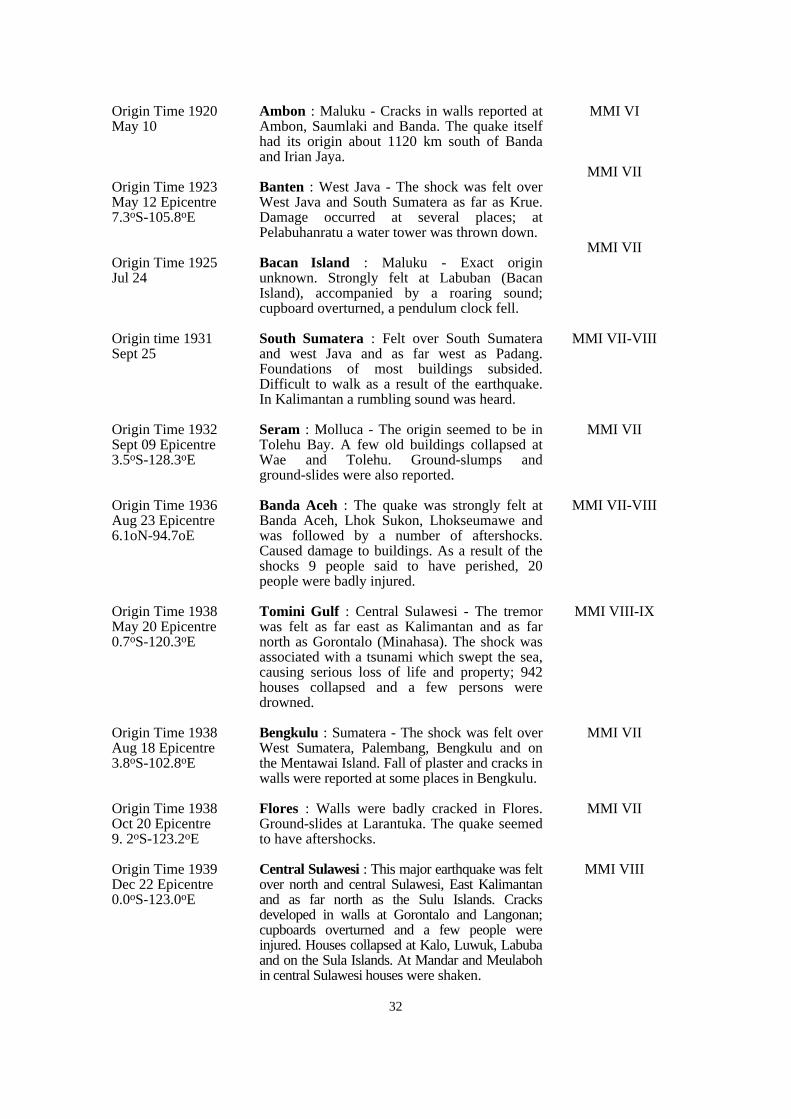
Ambon : Maluku - Cracks in walls reported atAmbon, Saumlaki and Banda. The quake itselfhad its origin about 1120 km south of Bandaand Irian Jaya.
Banten : West Java - The shock was felt overWest Java and South Sumatera as far as Krue.Damage occurred at several places; atPelabuhanratu a water tower was thrown down.
Bacan Island : Maluku - Exact originunknown. Strongly felt at Labuban (BacanIsland), accompanied by a roaring sound;cupboard overturned, a pendulum clock fell.
South Sumatera : Felt over South Sumateraand west Java and as far west as Padang.Foundations of most buildings subsided.Difficult to walk as a result of the earthquake.In Kalimantan a rumbling sound was heard.
Seram : Molluca - The origin seemed to be inTolehu Bay. A few old buildings collapsed atWae and Tolehu. Ground-slumps andground-slides were also reported.
Banda Aceh : The quake was strongly felt atBanda Aceh, Lhok Sukon, Lhokseumawe andwas followed by a number of aftershocks.Caused damage to buildings. As a result of theshocks 9 people said to have perished, 20people were badly injured.
Tomini Gulf : Central Sulawesi - The tremorwas felt as far east as Kalimantan and as farnorth as Gorontalo (Minahasa). The shock wasassociated with a tsunami which swept the sea,causing serious loss of life and property; 942houses collapsed and a few persons weredrowned.
Bengkulu : Sumatera - The shock was felt overWest Sumatera, Palembang, Bengkulu and onthe Mentawai Island. Fall of plaster and cracks inwalls were reported at some places in Bengkulu.
Flores : Walls were badly cracked in Flores.Ground-slides at Larantuka. The quake seemedto have aftershocks.
Central Sulawesi : This major earthquake was feltover north and central Sulawesi, East Kalimantanand as far north as the Sulu Islands. Cracksdeveloped in walls at Gorontalo and Langonan;cupboards overturned and a few people wereinjured. Houses collapsed at Kalo, Luwuk, Labubaand on the Sula Islands. At Mandar and Meulabohin central Sulawesi houses were shaken.
MMI VI
MMI VII
MMI VII
MMI VII-VIII
MMI VII
MMI VII-VIII
MMI VIII-IX
MMI VII
MMI VII
MMI VIII
Origin Time 1920 May 10
Origin Time 1923May 12 Epicentre7.3oS-105.8oE
Origin Time 1925 Jul 24
Origin time 1931 Sept 25
Origin Time 1932 Sept 09 Epicentre3.5oS-128.3oE
Origin Time 1936 Aug 23 Epicentre6.1oN-94.7oE
Origin Time 1938 May 20 Epicentre0.7oS-120.3oE
Origin Time 1938 Aug 18 Epicentre3.8oS-102.8oE
Origin Time 1938Oct 20 Epicentre9. 2oS-123.2oE
Origin Time 1939Dec 22 Epicentre0.0oS-123.0oE
33
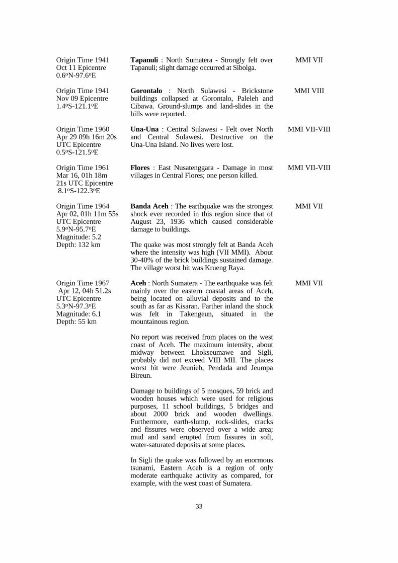
Tapanuli : North Sumatera - Strongly felt overTapanuli; slight damage occurred at Sibolga.
Gorontalo : North Sulawesi - Brickstonebuildings collapsed at Gorontalo, Paleleh andCibawa. Ground-slumps and land-slides in thehills were reported.
Una-Una : Central Sulawesi - Felt over Northand Central Sulawesi. Destructive on theUna-Una Island. No lives were lost.
Flores : East Nusatenggara - Damage in mostvillages in Central Flores; one person killed.
Banda Aceh : The earthquake was the strongestshock ever recorded in this region since that ofAugust 23, 1936 which caused considerabledamage to buildings.
The quake was most strongly felt at Banda Acehwhere the intensity was high (VII MMI). About30-40% of the brick buildings sustained damage.The village worst hit was Krueng Raya.
Aceh : North Sumatera - The earthquake was feltmainly over the eastern coastal areas of Aceh,being located on alluvial deposits and to thesouth as far as Kisaran. Farther inland the shockwas felt in Takengeun, situated in themountainous region.
No report was received from places on the westcoast of Aceh. The maximum intensity, aboutmidway between Lhokseumawe and Sigli,probably did not exceed VIII MII. The placesworst hit were Jeunieb, Pendada and JeumpaBireun.
Damage to buildings of 5 mosques, 59 brick andwooden houses which were used for religiouspurposes, 11 school buildings, 5 bridges andabout 2000 brick and wooden dwellings.Furthermore, earth-slump, rock-slides, cracksand fissures were observed over a wide area;mud and sand erupted from fissures in soft,water-saturated deposits at some places.
In Sigli the quake was followed by an enormoustsunami, Eastern Aceh is a region of onlymoderate earthquake activity as compared, forexample, with the west coast of Sumatera.
MMI VII
MMI VIII
MMI VII-VIII
MMI VII-VIII
MMI VII
MMI VII
Origin Time 1941 Oct 11 Epicentre 0.6oN-97.6oE
Origin Time 1941 Nov 09 Epicentre1.4oS-121.1oE
Origin Time 1960 Apr 29 09h 16m 20sUTC Epicentre 0.5oS-121.5oE
Origin Time 1961 Mar 16, 01h 18m 21s UTC Epicentre 8.1oS-122.3oE
Origin Time 1964 Apr 02, 01h 11m 55sUTC Epicentre5.9oN-95.7oE Magnitude: 5.2 Depth: 132 km
Origin Time 1967 Apr 12, 04h 51.2s UTC Epicentre 5.3oN-97.3oE Magnitude: 6.1 Depth: 55 km
34
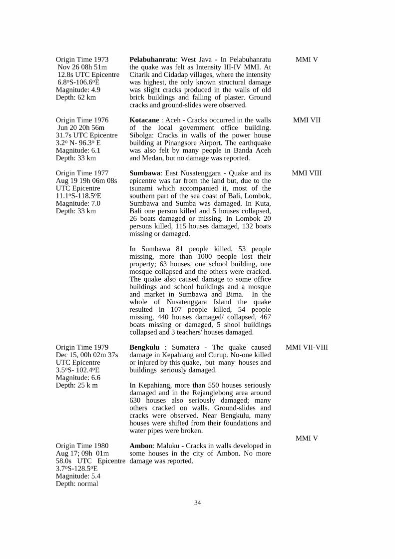
Pelabuhanratu: West Java - In Pelabuhanratuthe quake was felt as Intensity III-IV MMI. AtCitarik and Cidadap villages, where the intensitywas highest, the only known structural damagewas slight cracks produced in the walls of oldbrick buildings and falling of plaster. Groundcracks and ground-slides were observed.
Kotacane : Aceh - Cracks occurred in the wallsof the local government office building.Sibolga: Cracks in walls of the power housebuilding at Pinangsore Airport. The earthquakewas also felt by many people in Banda Acehand Medan, but no damage was reported.
Sumbawa: East Nusatenggara - Quake and itsepicentre was far from the land but, due to thetsunami which accompanied it, most of thesouthern part of the sea coast of Bali, Lombok,Sumbawa and Sumba was damaged. In Kuta,Bali one person killed and 5 houses collapsed,26 boats damaged or missing. In Lombok 20persons killed, 115 houses damaged, 132 boatsmissing or damaged.
In Sumbawa 81 people killed, 53 peoplemissing, more than 1000 people lost theirproperty; 63 houses, one school building, onemosque collapsed and the others were cracked.The quake also caused damage to some officebuildings and school buildings and a mosqueand market in Sumbawa and Bima. In thewhole of Nusatenggara Island the quakeresulted in 107 people killed, 54 peoplemissing, 440 houses damaged/ collapsed, 467boats missing or damaged, 5 shool buildingscollapsed and 3 teachers' houses damaged.
Bengkulu : Sumatera - The quake causeddamage in Kepahiang and Curup. No-one killedor injured by this quake, but many houses andbuildings seriously damaged.
In Kepahiang, more than 550 houses seriouslydamaged and in the Rejanglebong area around630 houses also seriously damaged; manyothers cracked on walls. Ground-slides andcracks were observed. Near Bengkulu, manyhouses were shifted from their foundations andwater pipes were broken.
Ambon: Maluku - Cracks in walls developed insome houses in the city of Ambon. No moredamage was reported.
MMI V
MMI VII
MMI VIII
MMI VII-VIII
MMI V
Origin Time 1973 Nov 26 08h 51m 12.8s UTC Epicentre 6.8oS-106.6oE Magnitude: 4.9 Depth: 62 km
Origin Time 1976 Jun 20 20h 56m 31.7s UTC Epicentre 3.2o N- 96.3o E Magnitude: 6.1 Depth: 33 km
Origin Time 1977 Aug 19 19h 06m 08sUTC Epicentre 11.1oS-118.5oE Magnitude: 7.0 Depth: 33 km
Origin Time 1979 Dec 15, 00h 02m 37s UTC Epicentre 3.5oS- 102.4oE Magnitude: 6.6 Depth: 25 k m
Origin Time 1980 Aug 17; 09h 01m58.0s UTC Epicentre3.7oS-128.5oE Magnitude: 5.4 Depth: normal
35
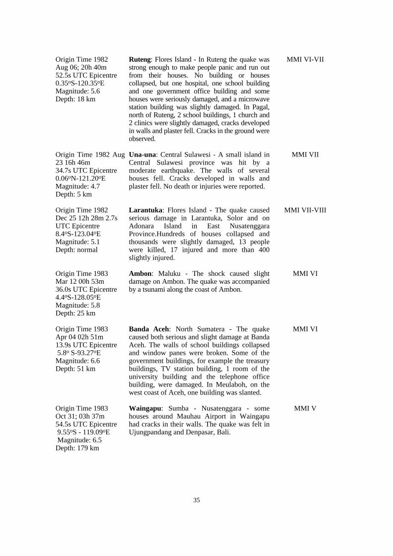
Ruteng: Flores Island - In Ruteng the quake wasstrong enough to make people panic and run outfrom their houses. No building or housescollapsed, but one hospital, one school buildingand one government office building and somehouses were seriously damaged, and a microwavestation building was slightly damaged. In Pagal,north of Ruteng, 2 school buildings, 1 church and2 clinics were slightly damaged, cracks developedin walls and plaster fell. Cracks in the ground wereobserved.
Una-una: Central Sulawesi - A small island inCentral Sulawesi province was hit by amoderate earthquake. The walls of severalhouses fell. Cracks developed in walls andplaster fell. No death or injuries were reported.
Larantuka: Flores Island - The quake causedserious damage in Larantuka, Solor and onAdonara Island in East NusatenggaraProvince.Hundreds of houses collapsed andthousands were slightly damaged, 13 peoplewere killed, 17 injured and more than 400slightly injured.
Ambon: Maluku - The shock caused slightdamage on Ambon. The quake was accompaniedby a tsunami along the coast of Ambon.
Banda Aceh: North Sumatera - The quakecaused both serious and slight damage at BandaAceh. The walls of school buildings collapsedand window panes were broken. Some of thegovernment buildings, for example the treasurybuildings, TV station building, 1 room of theuniversity building and the telephone officebuilding, were damaged. In Meulaboh, on thewest coast of Aceh, one building was slanted.
Waingapu: Sumba - Nusatenggara - somehouses around Mauhau Airport in Waingapuhad cracks in their walls. The quake was felt inUjungpandang and Denpasar, Bali.
MMI VI-VII
MMI VII
MMI VII-VIII
MMI VI
MMI VI
MMI V
Origin Time 1982 Aug 06; 20h 40m 52.5s UTC Epicentre0.35oS-120.35oE Magnitude: 5.6 Depth: 18 km
Origin Time 1982 Aug23 16h 46m 34.7s UTC Epicentre0.06oN-121.20oE Magnitude: 4.7 Depth: 5 km
Origin Time 1982 Dec 25 12h 28m 2.7sUTC Epicentre8.4oS-123.04oE Magnitude: 5.1 Depth: normal
Origin Time 1983 Mar 12 00h 53m 36.0s UTC Epicentre4.4oS-128.05oE Magnitude: 5.8 Depth: 25 km
Origin Time 1983 Apr 04 02h 51m 13.9s UTC Epicentre 5.8o S-93.27oE Magnitude: 6.6 Depth: 51 km
Origin Time 1983 Oct 31; 03h 37m 54.5s UTC Epicentre 9.55oS - 119.09oE Magnitude: 6.5 Depth: 179 km
36
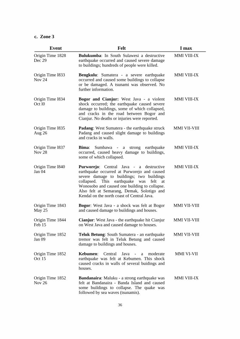
c. Zone 3
Bulukumba: In South Sulawesi a destructiveearthquake occurred and caused severe damageto buildings; hundreds of people were killed.
Bengkulu: Sumatera - a severe earthquakeoccurred and caused some buildings to collapseor be damaged. A tsunami was observed. Nofurther information.
Bogor and Cianjur: West Java - a violentshock occurred; the earthquake caused severedamage to buildings, some of which collapsed,and cracks in the road between Bogor andCianjur. No deaths or injuries were reported.
Padang: West Sumatera - the earthquake struckPadang and caused slight damage to buildingsand cracks in walls.
Bima: Sumbawa - a strong earthquakeoccurred, caused heavy damage to buildings,some of which collapsed.
Purworejo: Central Java - a destructiveearthquake occurred at Purworejo and causedsevere damage to buildings; two buildingscollapsed. This earthquake was felt atWonosobo and caused one building to collapse.Also felt at Semarang, Demak, Solotigo andKendal on the north coast of Central Java.
Bogor: West Java - a shock was felt at Bogorand caused damage to buildings and houses.
Cianjur: West Java - the earthquake hit Cianjuron West Java and caused damage to houses.
Teluk Betung: South Sumatera - an earthquaketremor was felt in Teluk Betung and causeddamage to buildings and houses.
Kebumen: Central Java - a moderateearthquake was felt at Kebumen. This shockcaused cracks in walls of several buidings andhouses.
Bandanaira: Maluku - a strong earthquake wasfelt at Bandanaira - Banda Island and causedsome buildings to collapse. The quake wasfollowed by sea waves (tsunamis).
MMI VIII-IX
MMI VIII-IX
MMI VIII-IX
MMI VII-VIII
MMI VIII-IX
MMI VIII-IX
MMI VII-VIII
MMI VII-VIII
MMI VII-VIII
MMI VI-VII
MMI VIII-IX
Origin Time 1828 Dec 29
Origin Time l833 Nov 24
Origin Time l834 Oct l0
Origin Time l835 Aug 26
Origin Time l837 Nov 28
Origin Time l840 Jan 04
Origin Time 1843 May 25
Origin Time 1844 Feb 15
Origin Time 1852 Jan 09
Origin Time 1852 Oct 15
Origin Time 1852 Nov 26
Event Felt I max
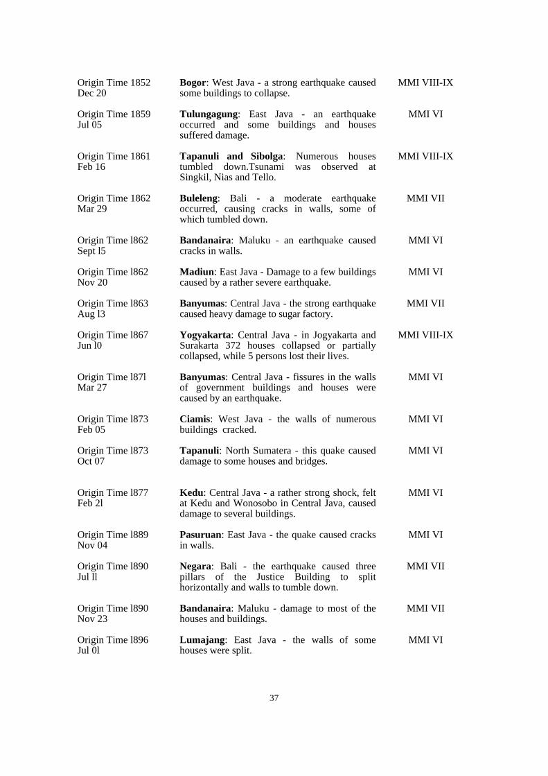
37
Bogor: West Java - a strong earthquake causedsome buildings to collapse.
Tulungagung: East Java - an earthquakeoccurred and some buildings and housessuffered damage.
Tapanuli and Sibolga: Numerous housestumbled down.Tsunami was observed atSingkil, Nias and Tello.
Buleleng: Bali - a moderate earthquakeoccurred, causing cracks in walls, some ofwhich tumbled down.
Bandanaira: Maluku - an earthquake causedcracks in walls.
Madiun: East Java - Damage to a few buildingscaused by a rather severe earthquake.
Banyumas: Central Java - the strong earthquakecaused heavy damage to sugar factory.
Yogyakarta: Central Java - in Jogyakarta andSurakarta 372 houses collapsed or partiallycollapsed, while 5 persons lost their lives.
Banyumas: Central Java - fissures in the wallsof government buildings and houses werecaused by an earthquake.
Ciamis: West Java - the walls of numerousbuildings cracked.
Tapanuli: North Sumatera - this quake causeddamage to some houses and bridges.
Kedu: Central Java - a rather strong shock, feltat Kedu and Wonosobo in Central Java, causeddamage to several buildings.
Pasuruan: East Java - the quake caused cracksin walls.
Negara: Bali - the earthquake caused threepillars of the Justice Building to splithorizontally and walls to tumble down.
Bandanaira: Maluku - damage to most of thehouses and buildings.
Lumajang: East Java - the walls of somehouses were split.
MMI VIII-IX
MMI VI
MMI VIII-IX
MMI VII
MMI VI
MMI VI
MMI VII
MMI VIII-IX
MMI VI
MMI VI
MMI VI
MMI VI
MMI VI
MMI VII
MMI VII
MMI VI
Origin Time 1852 Dec 20
Origin Time 1859Jul 05
Origin Time 1861 Feb 16
Origin Time 1862 Mar 29
Origin Time l862 Sept l5
Origin Time l862 Nov 20
Origin Time l863 Aug l3
Origin Time l867 Jun l0
Origin Time l87l Mar 27
Origin Time l873 Feb 05
Origin Time l873 Oct 07
Origin Time l877 Feb 2l
Origin Time l889 Nov 04
Origin Time l890 Jul ll
Origin Time l890 Nov 23
Origin Time l896Jul 0l
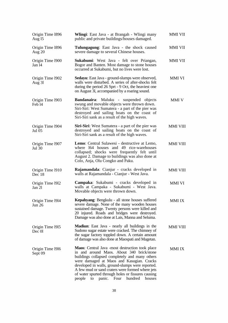
38
MMI VII
MMI VII
MMI VII
MMI VI
MMI V
MMI VIII
MMI VIII
MMI VIII
MMI VI
MMI IX
MMI VIII
MMI IX
Origin Time l896Aug l5
Origin Time l896 Aug 20
Origin Time l900 Jan l4
Origin Time l902 Aug 3l
Origin Time l903 Feb l4
Origin Time l904 Jul 05
Origin Time l907 Jul 30
Origin Time l910Dec 18
Origin Time l9l2Jan 2l
Origin Time l9l4 Jun 26
Origin Time l9l5 Dec 0l
Origin Time l9l6 Sept 09
Wlingi: East Java - at Brangah - Wlingi manypublic and private buildings/houses damaged.
Tulungagung: East Java - the shock causedsevere damage to several Chinese houses.
Sukabumi: West Java - felt over Priangan,Bogor and Banten. Most damage to stone housesoccurred at Sukabumi, but no lives were lost.
Sedayu: East Java - ground-slumps were observed,walls were disturbed. A series of after-shocks feltduring the period 26 Sprt - 9 Oct, the heaviest oneon August 3l, accompanied by a roaring sound.
Bandanaira: Maluku - suspended objectsswung and movable objects were thrown down.Siri-Siri: West Sumatera - a part of the pier wasdestroyed and sailing boats on the coast ofSiri-Siri sank as a result of the high waves.
Siri-Siri: West Sumatera - a part of the pier wasdestroyed and sailing boats on the coast ofSiri-Siri sank as a result of the high waves.
Lemo: Central Sulawesi - destructive at Lemo,where l64 houses and 49 rice-warehousescollapsed; shocks were frequently felt untilAugust 2. Damage to buildings was also done atColo, Anja, Olu Congko and Paku.
Rajamandala: Cianjur - cracks developed inwalls at Rajamandala - Cianjur - West Java.
Campaka: Sukabumi - cracks developed inwalls at Campaka - Sukabumi - West Java.Movable objects were thrown down.
Kepahyang: Bengkulu - all stone houses sufferedsevere damage. None of the many wooden housessustained damage. Twenty persons were killed and20 injured. Roads and bridges were destroyed.Damage was also done at Lais, Manna and Seluma.
Madiun: East Java - nearly all buildings in theSudono sugar estate were cracked. The chimney ofthe sugar factory toppled down. A certain amountof damage was also done at Maospati and Magetan.
Maos: Central Java -most destruction took placein and around Maos. About 340 brick/stonebuildings collapsed completely and many otherswere damaged at Maos and Kasugian. Cracksdeveloped in walls, ground-slumps were reported.A few mud or sand craters were formed where jetsof water spurted through holes or fissures causingpeople to panic. Four hundred houses
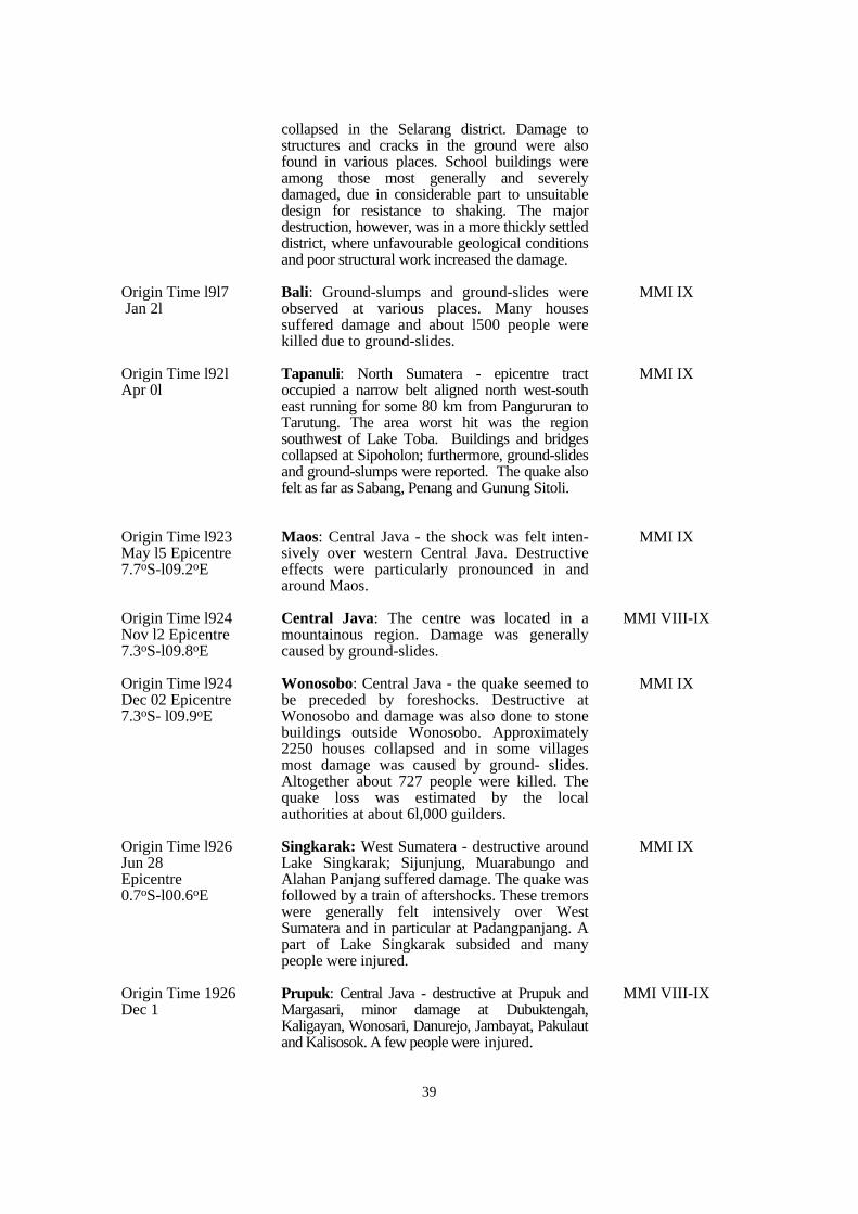
39
collapsed in the Selarang district. Damage tostructures and cracks in the ground were alsofound in various places. School buildings wereamong those most generally and severelydamaged, due in considerable part to unsuitabledesign for resistance to shaking. The majordestruction, however, was in a more thickly settleddistrict, where unfavourable geological conditionsand poor structural work increased the damage.
Bali: Ground-slumps and ground-slides wereobserved at various places. Many housessuffered damage and about l500 people werekilled due to ground-slides.
Tapanuli: North Sumatera - epicentre tractoccupied a narrow belt aligned north west-southeast running for some 80 km from Pangururan toTarutung. The area worst hit was the regionsouthwest of Lake Toba. Buildings and bridgescollapsed at Sipoholon; furthermore, ground-slidesand ground-slumps were reported. The quake alsofelt as far as Sabang, Penang and Gunung Sitoli.
Maos: Central Java - the shock was felt inten-sively over western Central Java. Destructiveeffects were particularly pronounced in andaround Maos.
Central Java: The centre was located in amountainous region. Damage was generallycaused by ground-slides.
Wonosobo: Central Java - the quake seemed tobe preceded by foreshocks. Destructive atWonosobo and damage was also done to stonebuildings outside Wonosobo. Approximately2250 houses collapsed and in some villagesmost damage was caused by ground- slides.Altogether about 727 people were killed. Thequake loss was estimated by the localauthorities at about 6l,000 guilders.
Singkarak: West Sumatera - destructive aroundLake Singkarak; Sijunjung, Muarabungo andAlahan Panjang suffered damage. The quake wasfollowed by a train of aftershocks. These tremorswere generally felt intensively over WestSumatera and in particular at Padangpanjang. Apart of Lake Singkarak subsided and manypeople were injured.
Prupuk: Central Java - destructive at Prupuk andMargasari, minor damage at Dubuktengah,Kaligayan, Wonosari, Danurejo, Jambayat, Pakulautand Kalisosok. A few people were injured.
MMI IX
MMI IX
MMI IX
MMI VIII-IX
MMI IX
MMI IX
MMI VIII-IX
Origin Time l9l7 Jan 2l
Origin Time l92l Apr 0l
Origin Time l923 May l5 Epicentre7.7oS-l09.2oE
Origin Time l924 Nov l2 Epicentre7.3oS-l09.8oE
Origin Time l924 Dec 02 Epicentre7.3oS- l09.9oE
Origin Time l926Jun 28 Epicentre 0.7oS-l00.6oE
Origin Time 1926 Dec 1
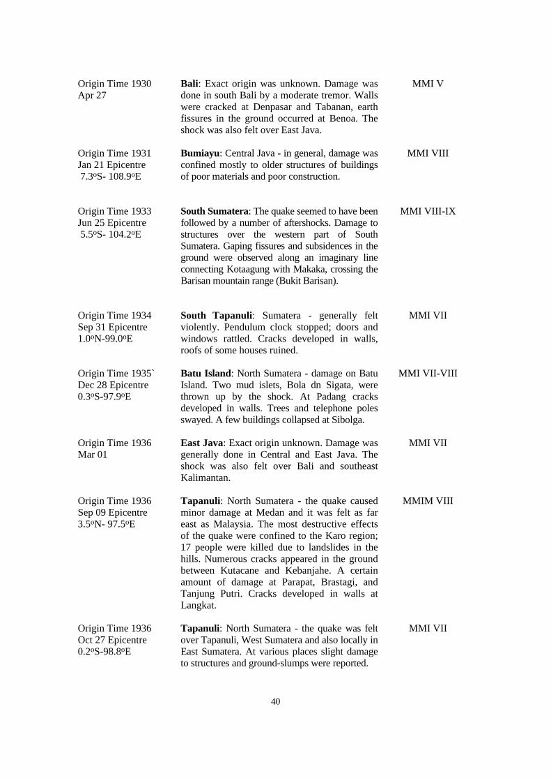
40
Bali: Exact origin was unknown. Damage wasdone in south Bali by a moderate tremor. Wallswere cracked at Denpasar and Tabanan, earthfissures in the ground occurred at Benoa. Theshock was also felt over East Java.
Bumiayu: Central Java - in general, damage wasconfined mostly to older structures of buildingsof poor materials and poor construction.
South Sumatera: The quake seemed to have beenfollowed by a number of aftershocks. Damage tostructures over the western part of SouthSumatera. Gaping fissures and subsidences in theground were observed along an imaginary lineconnecting Kotaagung with Makaka, crossing theBarisan mountain range (Bukit Barisan).
South Tapanuli: Sumatera - generally feltviolently. Pendulum clock stopped; doors andwindows rattled. Cracks developed in walls,roofs of some houses ruined.
Batu Island: North Sumatera - damage on BatuIsland. Two mud islets, Bola dn Sigata, werethrown up by the shock. At Padang cracksdeveloped in walls. Trees and telephone polesswayed. A few buildings collapsed at Sibolga.
East Java: Exact origin unknown. Damage wasgenerally done in Central and East Java. Theshock was also felt over Bali and southeastKalimantan.
Tapanuli: North Sumatera - the quake causedminor damage at Medan and it was felt as fareast as Malaysia. The most destructive effectsof the quake were confined to the Karo region;17 people were killed due to landslides in thehills. Numerous cracks appeared in the groundbetween Kutacane and Kebanjahe. A certainamount of damage at Parapat, Brastagi, andTanjung Putri. Cracks developed in walls atLangkat.
Tapanuli: North Sumatera - the quake was feltover Tapanuli, West Sumatera and also locally inEast Sumatera. At various places slight damageto structures and ground-slumps were reported.
MMI V
MMI VIII
MMI VIII-IX
MMI VII
MMI VII-VIII
MMI VII
MMIM VIII
MMI VII
Origin Time 1930 Apr 27
Origin Time 1931 Jan 21 Epicentre 7.3oS- 108.9oE
Origin Time 1933 Jun 25 Epicentre 5.5oS- 104.2oE
Origin Time 1934 Sep 31 Epicentre1.0oN-99.0oE
Origin Time 1935`Dec 28 Epicentre 0.3oS-97.9oE
Origin Time 1936 Mar 01
Origin Time 1936 Sep 09 Epicentre3.5oN- 97.5oE
Origin Time 1936 Oct 27 Epicentre0.2oS-98.8oE
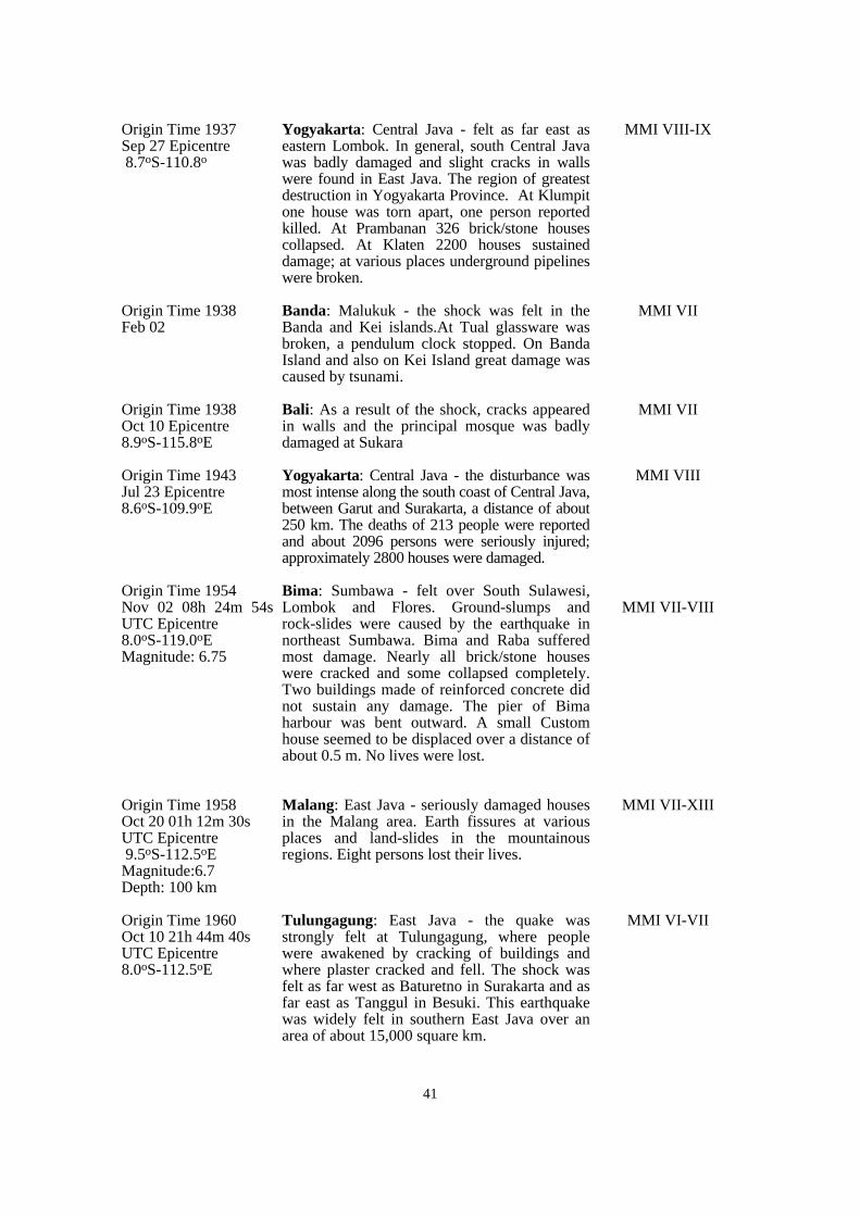
41
Yogyakarta: Central Java - felt as far east aseastern Lombok. In general, south Central Javawas badly damaged and slight cracks in wallswere found in East Java. The region of greatestdestruction in Yogyakarta Province. At Klumpitone house was torn apart, one person reportedkilled. At Prambanan 326 brick/stone housescollapsed. At Klaten 2200 houses sustaineddamage; at various places underground pipelineswere broken.
Banda: Malukuk - the shock was felt in theBanda and Kei islands.At Tual glassware wasbroken, a pendulum clock stopped. On BandaIsland and also on Kei Island great damage wascaused by tsunami.
Bali: As a result of the shock, cracks appearedin walls and the principal mosque was badlydamaged at Sukara
Yogyakarta: Central Java - the disturbance wasmost intense along the south coast of Central Java,between Garut and Surakarta, a distance of about250 km. The deaths of 213 people were reportedand about 2096 persons were seriously injured;approximately 2800 houses were damaged.
Bima: Sumbawa - felt over South Sulawesi,Lombok and Flores. Ground-slumps androck-slides were caused by the earthquake innortheast Sumbawa. Bima and Raba sufferedmost damage. Nearly all brick/stone houseswere cracked and some collapsed completely.Two buildings made of reinforced concrete didnot sustain any damage. The pier of Bimaharbour was bent outward. A small Customhouse seemed to be displaced over a distance ofabout 0.5 m. No lives were lost.
Malang: East Java - seriously damaged housesin the Malang area. Earth fissures at variousplaces and land-slides in the mountainousregions. Eight persons lost their lives.
Tulungagung: East Java - the quake wasstrongly felt at Tulungagung, where peoplewere awakened by cracking of buildings andwhere plaster cracked and fell. The shock wasfelt as far west as Baturetno in Surakarta and asfar east as Tanggul in Besuki. This earthquakewas widely felt in southern East Java over anarea of about 15,000 square km.
MMI VIII-IX
MMI VII
MMI VII
MMI VIII
MMI VII-VIII
MMI VII-XIII
MMI VI-VII
Origin Time 1937 Sep 27 Epicentre 8.7oS-110.8o
Origin Time 1938 Feb 02
Origin Time 1938 Oct 10 Epicentre8.9oS-115.8oE
Origin Time 1943 Jul 23 Epicentre 8.6oS-109.9oE
Origin Time 1954 Nov 02 08h 24m 54sUTC Epicentre 8.0oS-119.0oE Magnitude: 6.75
Origin Time 1958 Oct 20 01h 12m 30sUTC Epicentre 9.5oS-112.5oE Magnitude:6.7 Depth: 100 km
Origin Time 1960 Oct 10 21h 44m 40sUTC Epicentre 8.0oS-112.5oE
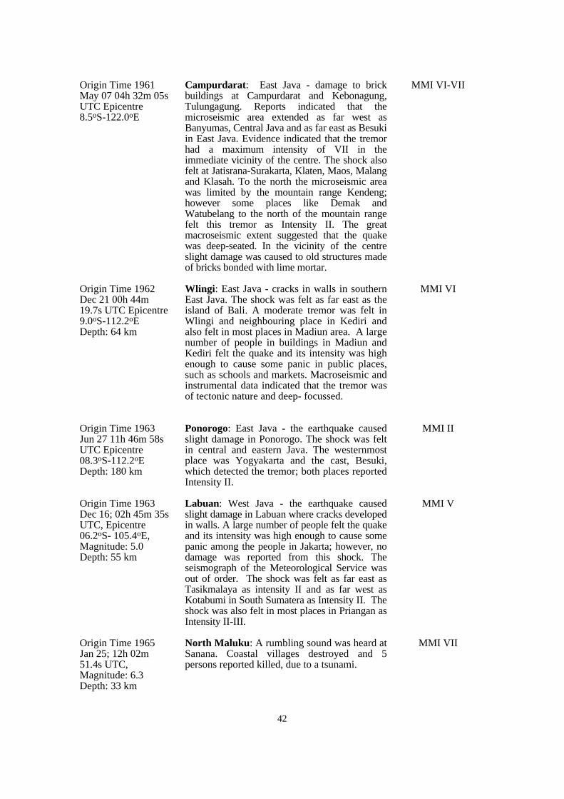
42
Campurdarat: East Java - damage to brickbuildings at Campurdarat and Kebonagung,Tulungagung. Reports indicated that themicroseismic area extended as far west asBanyumas, Central Java and as far east as Besukiin East Java. Evidence indicated that the tremorhad a maximum intensity of VII in theimmediate vicinity of the centre. The shock alsofelt at Jatisrana-Surakarta, Klaten, Maos, Malangand Klasah. To the north the microseismic areawas limited by the mountain range Kendeng;however some places like Demak andWatubelang to the north of the mountain rangefelt this tremor as Intensity II. The greatmacroseismic extent suggested that the quakewas deep-seated. In the vicinity of the centreslight damage was caused to old structures madeof bricks bonded with lime mortar.
Wlingi: East Java - cracks in walls in southernEast Java. The shock was felt as far east as theisland of Bali. A moderate tremor was felt inWlingi and neighbouring place in Kediri andalso felt in most places in Madiun area. A largenumber of people in buildings in Madiun andKediri felt the quake and its intensity was highenough to cause some panic in public places,such as schools and markets. Macroseismic andinstrumental data indicated that the tremor wasof tectonic nature and deep- focussed.
Ponorogo: East Java - the earthquake causedslight damage in Ponorogo. The shock was feltin central and eastern Java. The westernmostplace was Yogyakarta and the cast, Besuki,which detected the tremor; both places reportedIntensity II.
Labuan: West Java - the earthquake causedslight damage in Labuan where cracks developedin walls. A large number of people felt the quakeand its intensity was high enough to cause somepanic among the people in Jakarta; however, nodamage was reported from this shock. Theseismograph of the Meteorological Service wasout of order. The shock was felt as far east asTasikmalaya as intensity II and as far west asKotabumi in South Sumatera as Intensity II. Theshock was also felt in most places in Priangan asIntensity II-III.
North Maluku: A rumbling sound was heard atSanana. Coastal villages destroyed and 5persons reported killed, due to a tsunami.
MMI VI-VII
MMI VI
MMI II
MMI V
MMI VII
Origin Time 1961May 07 04h 32m 05sUTC Epicentre 8.5oS-122.0oE
Origin Time 1962 Dec 21 00h 44m 19.7s UTC Epicentre9.0oS-112.2oE Depth: 64 km
Origin Time 1963 Jun 27 11h 46m 58sUTC Epicentre08.3oS-112.2oE Depth: 180 km
Origin Time 1963 Dec 16; 02h 45m 35sUTC, Epicentre06.2oS- 105.4oE, Magnitude: 5.0 Depth: 55 km
Origin Time 1965 Jan 25; 12h 02m 51.4s UTC, Magnitude: 6.3 Depth: 33 km
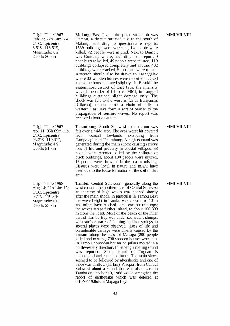
43
Malang: East Java - the place worst hit wasDampit, a district situated just to the south ofMalang; according to questionnaire reports,1539 buildings were wrecked, 14 people werekilled, 72 people were injured. Next to Dampitwas Gondang where, according to a report, 9people were kolled, 49 people were injured, 119buildings collapsed completely and another 402buildings were cracked, 5 mosques were ruined.Attention should also be drawn to Trenggalekwhere 33 wooden houses were reported crackedand some houses moved slightly. In Besuki, theeasternmost district of East Java, the intensitywas of the order of III to VI MMI; in Tanggulbuildings sustained slight damage only. Theshock was felt to the west as far as Banyumas(Cilacap); to the north a chain of hills inwestern East Java form a sort of barrier to thepropagation of seismic waves. No report wasreceived about a tsunami.
Tinambung: South Sulawesi - the tremor wasfelt over a wide area. The area worst hit coveredfrom coastal lowlands extending fromCampalagian to Tinambung. A high tsunami wasgenerated during the main shock causing seriousloss of life and property in coastal villages; 58people were reported killed by the collapse ofbrick buildings, about 100 people were injured,13 people were drowned in the sea or missing.Fissures were local in nature and might havebeen due to the loose formation of the soil in thatarea.
Tambu: Central Sulawesi - generally along thewest coast of the northern part of Central Sulawesian increase of high waves was noticed shortlyafter the main shock, in particular in Tambu Bay;the wave height in Tambu was about 8 to 10 mand might have reached some coconut-tree tops;the waves swept further inland, to about 100-300m from the coast. Most of the beach of the innerpart of Tambu Bay was under sea water; slumps,with surface trace of faulting and hot springs inseveral places were observed Loss of life andconsiderable damage were chiefly caused by thetsunami along the coast of Mapaga (200 peoplekilled and missing, 790 wooden houses wrecked).In Tambu 7 wooden houses on pillars moved in anorthwesterly direction. In Sabang a roaring soundwas reported. Small island of Tuguan isuninhabited and remained intact. The main shockseemed to be followed by aftershocks and one ofthose was shallow (11 km). A report from CentralSulawesi about a sound that was also heard inTambu on October 19, 1968 would strengthen thereport of earthquake which was deteced at0.1oN-119.8oE in Mapaga Bay.
MMI VII-VIII
MMI VII-VIII
MMI VII-VIII
Origin Time 1967 Feb 19; 22h 14m 55sUTC, Epicentre 8.5oS- 113.5oE, Magnitude: 6.2 Depth: 80 km
Origin Time 1967 Apr 11; 05h 09m 11sUTC, Epicentre03.7oS- 119.3oE, Magnitude: 4.9 Depth: 51 km
Origin Time 1968 Aug 14; 22h 14m 15sUTC, Epicentre 0.7oN- 119.8oE, Magnitude: 6.0 Depth: 23 km
44
Majene: South Sulawesi - this quake killed 64people, 97 others were injured and about 1287manmade structures were wrecked includingmosques which competely collapsed due topoor construction. The place worst hit wasMajene. Eighty percent of the brick buildingssustained serious damage; some of themcompletely collapsed. The pier of the harbourwas cracked in several places possibly due to asubsidence of the submarine surface just outsidethe harbour; gaping cracks, about 50 m long,caused three brick buildings serious damage;the centre market completely collapsedresulting in several deaths and severe propertydamage. Campalagian and Wonomulyo, locatedon alluvium and respectively about 30 km and50 km east of Majene, also sustained structuraldamage. General wooden houses were able toresist the shaking and much of the damage therewas caused by the collapse of unreinforcedconcrete walls. A tsunami generated by thequake struck the coastal villages north ofMajene. The wave height reached about 4 m atParasanga and Pilili. The construction in thevillages was principally wood frame and, due totheir location at the end of a bay, the woodenhouses were swept away by the tsunami. Inthese coastal places banana trees were almosttotally destroyed. Damage to the mosque wasprobably due to the fact that the old structureswere made of brick without reinforcing ironrods. Several bridges were damaged in thisnarrow lowland plain. Between Somba andParasanga great blocks of Neogene marls andtuffs tumbled down and in some places the roadwas buried by these blocks. Also from the edgeof the raised coral reefs greater and smallerparts were loosened and tumbled down onto thebeach. Fissures were also oberved at severalplaces. People interviewed said a roaring soundwas heard coming from the sea. The shock wasfelt as far south as Ujungpandang.
Sukabumi: West Java - a relatively strongearthquake was felt in southern West Java. Inthe Bogor area suspended objects swung as aresult of the shocks; in Campaka, where theintensity was highest, the only known structuraldamage was cracks produced in the walls ofsome badly constructed buildings. The shockwas also slightly felt in Jakarta. In the southBogor area an aftershock seemed to be felt onehour later. In Sukabumi a poorly-constructedbrick building was reported collapsed as a resultof this earthquake.
MMI VIII
MMI V
Origin Time 1969 Feb 23, 00h 36m 55.6s UTC, Epicentre 02.1oS- 118.5oE, Magnitude:6.1 Depth: 13 km
Origin Time 1969 Nov 02; 18h 53m 6.6s UTC, Epicentre6.5oS- 107.1oE Magnitude: 5.4 Depth: 57 km
45
Sibolga: North Sumatera - damage to brickbuildings developed in Pasaman, Natal,Pinangsore, Sibolga and Pasir Ulu estate.Fissures were observed in Sibolga and hotsprings developed in Tarutung. The shock wasgenerally felt in various places in the eastern partof north Sumatera and as far east as Singapore.No loss of life was reported from thisearthquake.
Mamuju: South Sulawesi - the quake rocked theMamuju area in the northwestern part of southSulawesi. Only slight damage to brick buildingsresulted from the tremor. The quake waspreceded by a roaring sound similar to that of abomb. The shock was felt as far south as Majene.
Southern Blitar - Trenggalek area experiencedan earthquake at 04h 36m L.T. in the morning.Gandusari reported a fairly strong shock asIntensity V-VI MMI. The tremor caused cracksin the walls of brick buildings and a greatnumber of people were awakened from sleep.The shock was felt as far as the Yogyakarta -Surakarta border and this far- extended felt areastrengthened the view that the shock was deeperthan normal.
Sumedang: West Java - at 21h 47m L.T. onDecember 19th, 1972 the Sumedang areaexperienced a tremor of moderate strength whichwas slightly shallower than normal, as indicatedby the small area affected. The quake causedslight damage to old brick buildings and panicamong the people. In Cibunar, Rancakaleng andPasaribu villages the intensity was IV MMI. InSindang village the same quake was felt as VMMI; ground-slides and ground fissures wereobserved.
Banten: West Java - this quake caused peopleto awaken. In Leuwiliang, southern Banten, onestone building collapsed and cracks developedin the walls of some houses. The shock was feltas far as Lampung and Pringsewu in South Su-matera and also in Jakarta by some people.
Banda Island: Maluku - heavy damage atBandanaira, 81 houses seriously damaged, 4houses moderately damaged and 2 houses slightlydamaged. The earthquake was followed by atsunami.
MMI V-VI
MMI IV
MMI V-VI
MMI V
MMI VI
MMI VII
Origin Time 1971 Feb 04; 15h 33m 22sGMT Epicentre 0.6oN-98.8oE Magnitude: 6.3 Depth: normal
Origin Time 1972Sept 06; 08h 00m 25.3s UTC Epicentre.5oS- 119.1oE Magnitude: 5.8 Depth: 36 km
Origin Time 1972Nov 04; 21h 36m54.0s Epicentre 8.4°VS-112.2°VE East Java: Magnitude: 6.0 Depth: 126 km
Origin Time 1972 Dec 19; 14h 47m 00.0s UTC, Epicentre 06.9oS-107.8oE Magnitude: 4.5 Depth: very shallow
Origin Time 1974 Nov 09; 19h 10m 55.2s UTC Epicentre6.5oS- 105.3oE Magnitude: 6.1 Depth: 51 km
Origin Time 1975 Jan 15; 09h 42m 24sUTC Epicentre 5.0oS- 130.0oE Magnitude: 5.9 Depth: Normal
46
Sanana : Sulu Island - the shock felt by manypeople in Sanana - Sulu Island at 01.30 UTC for8 seconds and at 02.24 UTC for 1.5 seconds.Cracks in walls and plaster falling. Theearthquake was followed by a tsunami. Theheight of sea water was about 1.20 m; it reachedthe road in Sanana, and caused people to panic.No persons killed.
Kupang: Timor Island - the walls of many housesfell, cracks in walls, plaster fell. No damage tobuildings or houses of good construction. Theearthquake was followed by a sound like thunderfrom the ground.
Purwokerto: Almost everyone was awakenedfrom sleep due to the earthquake and the soundsfrom the buildings/houses. The shock was alsofelt at Ajibarang Kedungbanteng, Tegal,Brebes, Pekalongan, Magelang and Semarang.No damage reported.
Bime, Eipomek, Nalca and Okbad in IrianJaya: Severe damage occurred in Langda,Ambon, Japil, Oksibil. Due to the lack of transportand communications no complete report available.
Sepirit and Busungbiru: 90% brick buildingsand houses collapsed. In Tabanan and Jembranamore than 75% buildings and houses severelydamaged, 559 people killed, 850 people seriouslyinjured and more than 3200 injured.
Nalca: Bime - 62 people killed. At Landa, 46people killed. The wooden houses of nativepeople which were built on the slope, collapsedand were buried by a landslide, but the woodenhouses which were built on the flat groundsuffered no damage.
Bangli: Bali - this relatively strong quake wasfelt in Bangli and surroundings. In Kayubihivillage cracks were produced in the walls of onesemi-permanent school building; a monumentand temple collapsed. About 90% of housesdamaged. In Banjar Antugan Jehem village morethan 80% of buildings and houses cracked.Ground-slides and cracks in the ground wereobserved in the Melangit River, about 500 meastward of Kayubihi and Antugan. No killed orinjured reported.
MMI VI
MMI VII
MMI IV
MMI VIII
MMI VIII
MMI VIII
MMI VI
Origin Time 1975 Mar 05; 00h 22m 23sUTC Epicentre 02.4oS-126.1oE Magnitude: 6.5 Depth: normal
Origin Time 1975 Jul 30; 09h 17m 11.6s UTC Epicentre9.9oS-123.9oE Magnitude: 6.1 Depth: 30-50 km
Origin Time 1976 Feb 14; 20h 31m 49sUTC Epicentre7.2oS- 109.3oE Magnitude: 6.1 Depth: 30-50 km
Origin Time 1976 Jun 25; 19h 18m 55.5s UTC Epicentre4.6oS-139.8oE Magnitude: 7.0 Depth: 33 km
Origin Time 1976 Jul 14, 07h 13m 22sUTC Epicentre 8.2oS- 114.9oE Magnitude: 6.2 Depth: normal
Origin Time 1976 Oct 29; 02h 51m 01sUTC Epicentre 4.7oS- 140.2oE Magnitude: 6.0 Depth: 30-50 km
Origin Time 1977 Jan 26; 13h 11m 29.5s UTC Epicentre8.25oS- 115.3oE Magnitude: 5.0 Depth: normal
47
Pasaman: West Sumatera - in Sinurut thequake caused serious damage to 737 houses,one market, 7 school buildings, 8 mosques alsodamaged. Almost all wooden houses in thatarea were slanted and shifted from theirfoundations. Cracks in the ground 5-75 cm widewere observed. The quake was felt at Padangand Padangpanjang with intensity of III MMI.No killed or injured reported.
Marapi: West Sumatera - the quake causedcracks in some houses in Pinangsore - Sibolga.The shock also felt in Padang, Padangpanjang,Bukittinggi, Batusangkar and caused people topanic. Two days after, at midnight on April 30,the Marapi disaster occurred, because materialssuch as stones and soil crashed down from thetop and slopes of the mountain. The materialsfrom Marapi washed away everything andresulted in 64 people killed, 9 people missing,193 houses collapsed, 42 bridges damaged, 138dam and irrigation schemes destroyed, 34 cattlekilled. The disaster might have been caused notonly by the quake but also by the heavy rain inMarapi and the surrounding district.
Lombok: Nusatenggara - in Tanjung many housesand buildings collapsed, especially the poorlydesigned structures and old houses/buildings.Some people killed and injured. Other affectedareas were Buyan, Gangga, Kediri, Cakranegara,Narmada, where many buildings and houses werealso seriously damaged and some even collapsed.Two mosques in Narmada and Cakranegarasuffered moderate damage, cracks developed intheir walls. The tower of the mosque in Kediricracked. In Ampenan and Mataram the quakecaused only slight damage to houses/buildings.In fact the damage to houses/buildings was dueto old or poor construction.
Karangasem: Bali - the quake caused moderatedamage to buildings and houses in Karangasem,Ampenan, and Mataram on Lombok Island,eastward of Bali.
Tasikmalaya: West Java - in Tasikmalaya andsurroundings the quake caused 163 houses andbuildings to collapse; 1430 houses were seriouslydamaged; one meeting hall and 24 schoolbuildings were damaged, 3 mosques collapsedand 29 were seriously damaged; 159 news-standswere severely damaged.
MMI VIII
MMI V
MMI VIII-IX
MMI VI
MMI VII
Origin Time 1977 Mar 08; 23h 17m 29sUTC Epicentre 0.4oN-99.7oE Magnitude: 6.0 Depth: normal
Origin Time 1979 Apr 28; 03h 29m 55.5s UTC Epicentre0.7oS-99.5oE Magnitude: 5.7 Depth: normal
Origin Time 1979 May 30, 09h 38m 53s UTC Epicentre8.21oS- 115.95oEMagnitude: 6.1 Depth: 25 km
Origin Time 1979 Oct 20, 01h 41m 09sUTC Epicentre 8.25oS-116.0oE Magnitude: 5.8 Depth: normal
Origin Time 1979 Nov 02, 15h 53m2.6s UTC Epicentre8.6oS-107.8oE Magnitude: 6.4 Depth: 64 km
48
In Garut most old and poorly constructed stonehouses collapsed; many permanent houses hadcracks in walls; 10 people killed, 12 seriouslyinjured. Cracks in the ground in an east-westdirection were observed. The quake wasaccompanied by a roaring sound from under theground. Abnormal sea tides were observed 2days before the quake occurred in Pameungpeuk.
Karangasem: Bali - in Karangasem thisearthquake killed 5 persons, seriously injured 34and slightly injured 250. Some houses collapsed,some were seriously damaged, many slightlydamaged. In Abang, 17 people killed, 9seriously injured, 300 slightly injured. Somehouses collapsed, others seriously or slightlydamaged. In Culik, many houses collapsed. InKubu, one person killed, 2 persons seriouslyinjured and 18 slightly injured. Most buildingsseriously or slightly damaged, but no buildingcollapsed. In Bebandem, one person killed, 2seriously injured and 4 slightly injured. Buildingsand houses seriously or slightly damaged. Cracksin the road and land were observed along 0.5 km.
Tasikmalaya: West Java - in Singaparna manyhouses had cracks in walls but in Tasikmalayaitself only some houses were cracked. In Garutand surroundings the poorly constructed houseshad cracks in walls, also in the district ofSukawening, Pasanggrahan, Jamberea,Cari-ngin, many cracks developed in walls. Inthe Singajaya district 10 elementary schoolbuildings slanted. The quake also caused cracksin houses in Cilacap, Central Java. The shockswere felt in Bandung at Intensity III.
Karanganyar: Central Java - the quake shookKarang-anyar and surroundings and causedslight damage to some houses.
Yogyakarta: Central Java - the shock was feltin Yogyakarta and caused small crakcs in thewalls of the Ambarukmo Hotel. No otherbuildings or houses damaged.
Sukabumi: West Java - the quake was felt insome places in the Sukabumi and Bogor areas.The shock caused serious or slight damage tomany houses and buildings and 4 people wereinjured. No loss of life.
MMI VII
MMI VI-VIII
MMI V-VI
MMI VI
MMI VII
MMI VII
Origin Time 1979 Dec 17, 19h 58m 26sUTC Epicentre 8.4oS- 115.8oE Magnitude: 5.0 Depth: 28 km
Origin Time 1980 Apr 16, 12h 18m 19sUTC Epicentre 8.25oS-108.8oE Magnitude: 6.4 Depth: normal
Origin Time 1981 Jan 01, 02h 09m 52sUTC Epicentre 7.7oS-111.0oE Magnitude: 6.0 Depth: shallow
Origin Time 1981 Mar 13, 23h 22m 35sUTC Epicentre 8.95oS-110.4oE Magnitude:6.0 Depth: normal
Origin Time 1982 Feb 1, 09h 17m 50.2sUTC Epicentre 7.0oS-106.9oE Magnitude: 5.3 Depth: 25 km
49
Toli-toli: Central Sulawesi - according to thenews in the Kompas Newspaper, on October 21,1983 the quake caused 20 houses in Toli-toli tocollapse and 15 aborigine's houses wereseriously damaged.
Central Sulawesi: The quake was strongenough to cause 2 people killed, 4 injured and24 houses to be seriously damaged, of which 20collapsed. The shock was also felt in Palu, thecapital of Central Sulawesi Province.
Mamuju: Central Sulawesi - this quake killed 2persons, seriously injured 5, slightly injured 84.In the affected area 15 government officebuildings, 23 government houses, 31 schoolbuildings, one clinic, one news-stand seriouslydamaged and about 16 government officebuildings, 12 government houses, 14 schoolbuildings and two clinics slightly damaged.Besides the above mentioned damage, 213 localpeople's houses, 4 shops, 18 mosques and 1church were seriously damaged. Ground-slumps were observed in Tapalang. The shockwas also accompanied by a tsunami.
Pahae Jae - Tapanuli: North Sumatera - inSarula, three elementary school buildings andone junior high school building collapsed, onesenior high school building was seriouslydamaged and the school caretaker's houseshifted 30 cm from its foundations. Cracksdeveloped in the walls of the local authorityoffice, post office building, clinic. InPerdamaian and Selangkitang villages twoelementary school buildings partly collapsed.Ground-slides were observed. On the roadbetween Tarutung and Padangsidempuan cracksin the ground developed and sulphurous gaswas emitted. In Pinangsori-Sibolga small cracksdeveloped in the walls of houses. The quakewas felt as far as Gunung Sitoli on Nias Island,Rantau Prapat and Balige (Toba Lake).According to the news, the shock was also feltalong the west coast of Malaysia.
MMI VI
MMI VII
MMI VII
MMI VIII
Origin Time 1983 Oct 16, 05h 32m 24.8s UTC Epicentre1.48oN- 121.01oEMagnitude: 5.9 Depth: 46 km
Origin Time 1983 Oct 25, 00h 36m 19.4s UTC Epicentre1.6oN- 120.8oE Magnitude: 6.0 Depth: 50 km
Origin Time 1984 Jan 08, 15h 24m 14.4 sUTC Epicentre 2.94oS- 118.73oEMagnitude: 5.9 Depth: 95 km
Origin Time 1984 Aug 27, 06h 41m 25.5s UTC Epicentre1.5oS- 98.94oE Magnitude: 4.8 Depth: 53 km
50
d. Zone 4
Jepara: Central Java - the earthquake was feltat Jepara and reported as VI-VII on the MMIscale.
Batavia/Jakarta: Shocks caused damage tobuildings and cracked walls. No deaths orinjuries were reported.
Mojokerto: East Java - at Mojokerto, about 60km west of Surabaya, a shock occurred andcaused damage and loss of property.
Cirebon: West Java - a moderate earthquakewas felt and caused cracks in walls. No furtherinformation.
Semarang: Central Java - an earthquake wasfelt at Semarang and caused cracks in walls.
Karawang: West Java - a rather severe shockwas felt at Karawang, West Java, where wallsof some houses were fissured.
Banyubiru: Central Java - some buildings andhouses suffered considerable damage by theearthquake.
Ambarawa: Central Java - because of anearthquake, walls of some houses and barrackswere fissured.
Salatiga: Central Java - a rather strong shockfelt at Salatiga caused fissures in walls.
Mandailing: North Sumatera - many houseswere damaged due to the earthquake.
Kuningan: West Java - the quake was felt atKuningan, Sumedang and Manonjaya. 628houses damaged and seven people killed.
Pati: Central Java - this quake also felt atJuwana; caused many houses to fall. Severalpeople killed and injured.
Prapat: North Sumatera - the shock causedsevere damage to three buildings.
MMI VII
MMI VII-VIII
MMI VII-VIII
MMI VII-VIII
MMI VII-VIII
MMI VI
MMI VII
MMI VI
MMI VI
MMI VI
MMI VII-VIII
MMI VIII
MMI VI
Origin Time 1821 Dec 25
Origin Time l833 Jan 28 05h 00m 00s
Origin Time l836 Mar 22
Origin Time l853 Nov l0
Origin Time l856 Jan l9
Origin Time l862 May 24
Origin Time l865 Jul l7
Origin Time l866 Apr 22
Origin Time l872 Oct l0
Origin Time l873 Aug l9
Origin Time l875 Oct 25
Origin Time l890 Dec l2
Origin Time l892 May l7
Event Felt I max
51
Sangkulirang: East Kalimantan - damage atSangkulirang and more intense on the islands ofRending, Kaliorang and Sekuran. Housescollapsed and gaping fissures were observed.The shock was associated with a tsunami whichswept the sea, causing considerable damage atSekuran.
Tarakan: East Kalimantan - the earthqukae wasrecorded by sensitive seismographs all over theworld. The shock was strongly felt at Tarakanabout l40 km north of the centre and wasfollowed by a number of aftershocks. Brickbuildings collapsed, cracks developed in theground, and streams were affected. The kitchenof a house seemed to be displaced over adistance of about l m toward the west. Structureson solid ground suffered little damage.
East Kalimantan - the tremor was generallyfelt at several places in East Kalimantan and asfar north as the island of Tarakan. It wasfollowed by aftershocks. As a result of the mainshock, seven houses collapsed.
Tarakan: East Kalimantan - the exact originwas unknown, but the shock was strongly felt atTarakan and Lungkas and it was preceded by arumbling sound.
Donggala: Central Sulawesi - a majorearthquake caused damage to buildings atDonggala, Borowaru and neighbouring places.Earth fissures and subsidences in the groundwere reported. The damage was mainlyconfined to the Palu Bay area. A tsunami wasobserved that caused serious loss of life andproperty in coastal villages. About 50 peoplesustained injuries and 50 died.
Sanana: Molluca - aftershocks were also felt onSula Island. Movable objects were overthrownand a rumbling sound was heard. At Sanana, 24houses collapsed, great fissures appeared in theground close to the market. At Wai Ipa, l4houses were damaged and at Wai Iau 2buildings sustained considerable damage.
Central Java: Fall of plaster and small cracksin walls in the Cirebon Residency. Moredamage was done at Sodomantra, Japara andManis Kidul.
East Java: Kembang and Surabaya wererocked; suspended objects swung. A brickbuilding collapsed at Brondong.
MMI VIII
MMI VIII
MMI VII
MMI VII
MMI VII
MMI VIII
MMI VII
MMI VII
Origin Time l92l May l4
Origin Time l923 Apr l9
Origin Time l924 Apr l3 Epicentre 0.3oN-ll8.2oE
Origin Time l925 Feb l4
Origin Time l927 Dec 0l Epicentre0.5oS-ll9.5oE
Origin Time l936Oct l9 Epicentre 2.0oS-l26.0oE
Origin Time l939 Jun 27 Epicentre6.9oS-l08.5oE
Origin Time l939 Aug ll Epicentre 6.5oS-ll2.4oE

52
East Java: Destructive in and aroundGresik. Felt slightly in South Kalimantanand as far west as West Java.
Tapanuli: North Sumatera - at Sarula andOnang Hasang in Tapanuli the intensityreached VII MMI; damage to brick buildingsand ground-slumps were observed.
Bantar Kawung: Central Java - the shockwas generally felt in western Central Java.The place worst hit was Buaran, about 6 kmwest of Bumiayu; further, in BantarKawung and Jipang, respectively some l2and l7 km west of Bumiayu, most brickbuildings suffered considerable damage. Inthe affected area l377 buildings sustaineddamage; wooden houses generally resistedshaking but some poorly constructedbuildings slanted toward east or west andsome collapsed completely. Despite thisonly one person was reported killed and 6injured. The damage might have been dueto old structures made of brick which arenot well cemented and are withouthreinforcing iron rods. The unconsolidatedriver deposits may largely be responsible.
MMI VII
MMI VII
MMI VII-VIII
Origin Time l950un l9; l2h 36m 54sUTC Epicentre6.2oS-ll2.5oE
Origin Time l965 Jul 25 03h 40m 40.4s GMT Epicentre2.0oN-99.3oE Magnitude: 5.3Depth: 98 km
Origin Time l97l Jun l6 l4h 44m 22.5s Epicentre.2oS-l09.loE Magnitude: 5.2Depth: 35 km
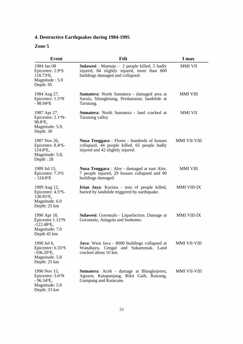
53
4. Destructive Earthquakes during 1984-1995
Zone 5
Sulawesi : Mamuju - 2 people killed, 5 badlyinjured, 84 slightly injured, more than 800buildings damaged and collapsed.
Sumatera: North Sumatera - damaged area atSarula, Silangkitang, Perdamaian, landslide atTarutung.
Sumatera: North Sumatera - land cracked atTarutung valley
Nusa Tenggara : Flores - hundreds of housescollapsed, 44 people killed, 65 people badlyinjured and 42 slightly injured.
Nusa Tenggara : Alor - damaged at east Alor,7 people injured, 29 houses collapsed and 90buildings damaged.
Irian Jaya: Kurima - tens of people killed,buried by landslide triggered by earthquake.
Sulawesi: Gorontalo - Liquefaction. Damage atGorontalo, Atingola and Inobonto.
Java: West Java - 8000 buildings collapsed atWanahayu, Cengal and Sukamenak. Landcracked about 10 km.
Sumatera: Aceh - damage at Blangkejeren,Agusen, Kutapanjang, Rikit Gaib, Rawung,Gumpang and Kutacane.
MMI VII
MMI VIII
MMI VII
MMI VII-VIII
MMI VIII
MMI VIII-IX
MMI VIII-IX
MMI VII-VIII
MMI VII-VIII
1984 Jan 08 Epicentre: 2.9oS118.73oE,Magnitude : 5.9 Depth: 95
1984 Aug 27, Epicentre: 1.5oN- 98.94oE
1987 Apr 27, Epicentre: 2.1oN-98.8oE, Magnitude: 5.9, Depth: 30
1987 Nov 26, Epicentre: 8.4oS-124.8oE,Magnitude: 5.8, Depth : 28
1989 Jul 15, Epicentre: 7.3oS- 124.8oE
1989 Aug 12, Epicentre: 4.5oS-138.95oE, Magnitude: 6.0 Depth: 25 km
1990 Apr 18, Epicentre 1.12oN-122.48oE, Magnitude: 7.0 Depth 45 km
1990 Jul 6, Epicentre: 6.55oS-106.20oE, Magnitude: 5.8 Depth: 25 km
1990 Nov 15, Epicentre: 3.6oN- 96.34oE, Magnitude: 5.0 Depth: 33 km
Event Felt I max
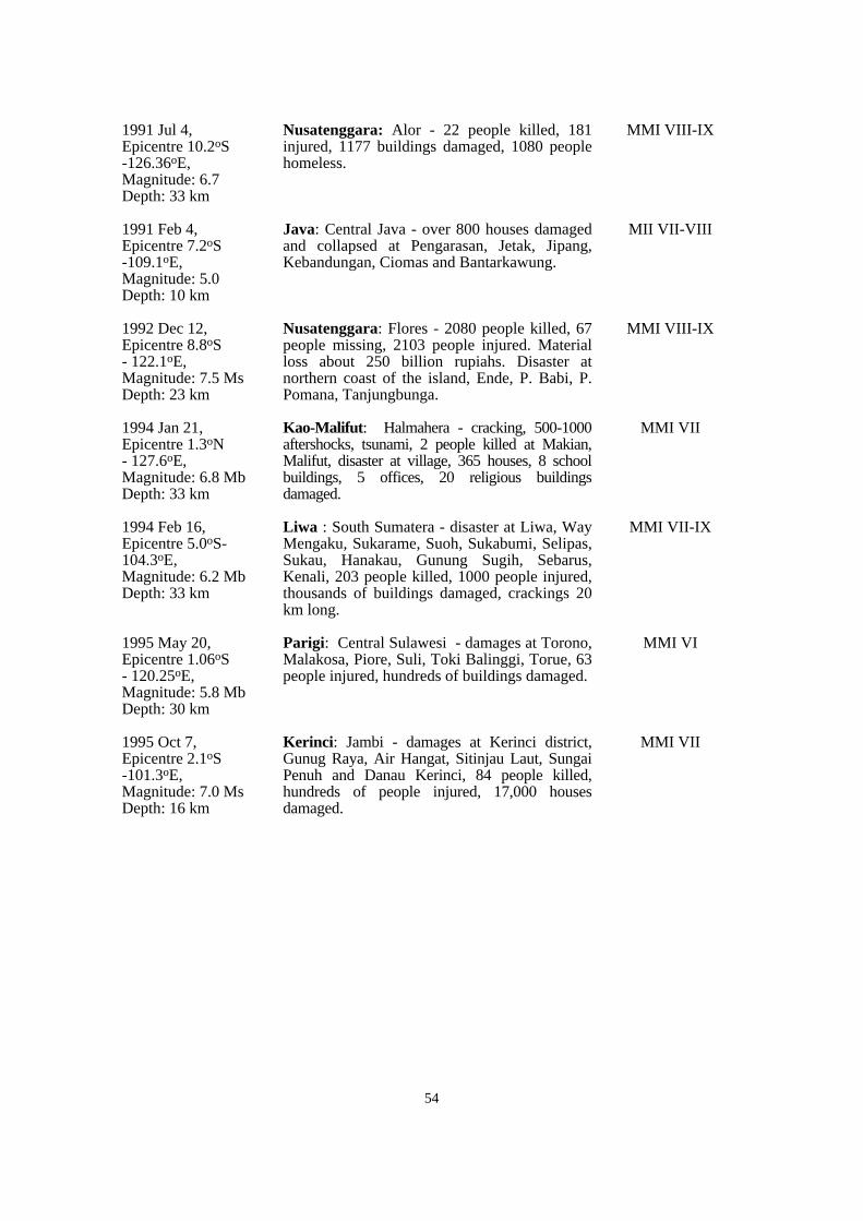
54
Nusatenggara: Alor - 22 people killed, 181injured, 1177 buildings damaged, 1080 peoplehomeless.
Java: Central Java - over 800 houses damagedand collapsed at Pengarasan, Jetak, Jipang,Kebandungan, Ciomas and Bantarkawung.
Nusatenggara: Flores - 2080 people killed, 67people missing, 2103 people injured. Materialloss about 250 billion rupiahs. Disaster atnorthern coast of the island, Ende, P. Babi, P.Pomana, Tanjungbunga.
Kao-Malifut: Halmahera - cracking, 500-1000aftershocks, tsunami, 2 people killed at Makian,Malifut, disaster at village, 365 houses, 8 schoolbuildings, 5 offices, 20 religious buildingsdamaged.
Liwa : South Sumatera - disaster at Liwa, WayMengaku, Sukarame, Suoh, Sukabumi, Selipas,Sukau, Hanakau, Gunung Sugih, Sebarus,Kenali, 203 people killed, 1000 people injured,thousands of buildings damaged, crackings 20km long.
Parigi: Central Sulawesi - damages at Torono,Malakosa, Piore, Suli, Toki Balinggi, Torue, 63people injured, hundreds of buildings damaged.
Kerinci: Jambi - damages at Kerinci district,Gunug Raya, Air Hangat, Sitinjau Laut, SungaiPenuh and Danau Kerinci, 84 people killed,hundreds of people injured, 17,000 housesdamaged.
MMI VIII-IX
MII VII-VIII
MMI VIII-IX
MMI VII
MMI VII-IX
MMI VI
MMI VII
1991 Jul 4, Epicentre 10.2oS-126.36oE, Magnitude: 6.7 Depth: 33 km
1991 Feb 4, Epicentre 7.2oS-109.1oE, Magnitude: 5.0 Depth: 10 km
1992 Dec 12, Epicentre 8.8oS- 122.1oE, Magnitude: 7.5 MsDepth: 23 km
1994 Jan 21, Epicentre 1.3oN- 127.6oE, Magnitude: 6.8 MbDepth: 33 km
1994 Feb 16, Epicentre 5.0oS-104.3oE, Magnitude: 6.2 MbDepth: 33 km
1995 May 20, Epicentre 1.06oS- 120.25oE, Magnitude: 5.8 MbDepth: 30 km
1995 Oct 7, Epicentre 2.1oS-101.3oE, Magnitude: 7.0 MsDepth: 16 km
55
V. EARTHQUAKE MONITORING PROGRAMME IN INDONESIA
1. INSTITUTIONS RELATED TO DISASTER MANAGEMENT IN INDONESIA
The disaster can hamper and disrupt both human life as well as the realization andthe result of development. So it is necessary that the disaster management should beplanned correctly and perfectly carried out, and well co-ordinated and integrated. Toguarantee the smoothness of the implementation in the disaster management operation itis necessary to form coordinating institutions.
a. National Level
(1) Institution
To cope with disaster at central level is a non-structural institution that is calledthe National Coordinating Agency for Disaster Management (BAKORNAS-PB =Badan Koordinasi Nasional Penanggulangan Bencana), which is responsible to thePresident of Indonesia. The Coordinating Agency for Disaster Management is chairedby the Minister Coordinnator for People's Welfare.
(2) Membership
Membership of the National Co-ordinating Agency for Disaster Managementconsists of:
* The Minister Co-ordinator for People's Welfare as Chairman concurrently member;
* The Minister of Social Affairs;
* The Minister of Home Affairs;
* The Minister of Health;
* The Minister of Public Works;
* The Minister of Communication;
* The Governor, Head of the Provincial Region;
* The Commander-in-Chief of the Armed Forces; and
* The Director General for Social Assistance Development, Department of SocialAffairs, as Secretary concurrently member.
(3) Co-opted Membership
Heads and officials of other related Departments and Non-GovernmentalOrganizations as co-opted members, i.e. :
* The Department of Defence and Security;
* The Department of Mines and Energy;
* The Department of Tourism, Post and Telecommunication;

56
* The Department of Trade and Industry;
* The Department of Agriculture;
* The Department of Forestry;
* The Ministry of the State Minister of Environment;
* The Agency for the Assessment and Application of Technology;
* The National Atomic Energy Agency;
* The National Aviation and Aerospace Institute; and
* The National Co-ordinating Agency for Surveys and Mapping.
Related Non-Governmental Organizations, i.e. :
* The Indonesian Red Cross;
* The Civil Defence;
* The Boy Scouts and Girl Guides; etc.
(4) Secretary
The Director General of Social Assistance Development, Department of SocialAffairs is Secratary concurrently member. In performing his duties the Secretary isassisted by a Deputy Secretary, who leads the Secretariat.
The Secretariat has the function of a center of co-ordination, planning, controlling,monitoring and evaluating and as a Clearing House. It is called the Indonesian DisasterManagement Center (IDMC).
(5) Working Groups
In the implementation of duties the Chairman of BAKOSNAS-PB would organizeworking groups in accordance with the existing requirements. Each working group islead by the Sectretary of BAKOSNAS-PB. Formation, assignment in details and workprocedures are stipulated by the Chairman of BAKORNAS-PB.
Each working group is lead by the respective Chairman and co-ordinated by theSecretary of the National Coordinating Agency for Disaster Management.
b. Provincial Level
The Provincial Government and related provincial government agenciesconnected to the disaster management become the extention of the NationalCo-ordinating Agency for Disaster Management organization in the provincial region.In performing his function, this co-ordination for disaster management is built in theorganization of the provincial government, assisted by the Armed Forces and otheragencies in the provincial regions, relevant to their own functions.
57
c. Executing Units
(1) Institution
It is a non-structural institution to cope with disaster in the district or municipallevel that is the Executing Unit of Disaster Management, which is responsible to theChairman of the National Co-ordinating Agency for Disaster Management and theGovernor, Head of the Provincial Region.
(2) Membership
Membership of the Executing Unit of Disaster Management consists of :
* Head of District or Major as Chief concurrently member;
* Commander of Military District as First Deputy Chief concurrently member;
* Head of Police Resort as Second Deputy Chief concurrently member;
* The Regional Secretary of District or Municipal Region as Secretaryconcurrently member;
* Chief of Civil Defence of District or Municipal Headquarters as member;
* Head of the Regional Offices of the related Departments and other relatedofficials in the District or Municipal Headquarters as members;
* The related community organizations and other organizations as co-opted members.
d. Disaster Management Task Forces
The Disaster Management Task Forces are the organizations developed to copewith disasters in the Sub-District level or in particular areas. Each Disaster ManagementTask Force has a Chief, Deputy Chief, Secretary and members with their jobdescriptions and responsibilities stated in the decision made by the Head of District orMajor in his capacity as the Chief of the Executing Unit of the Disaster Management.
2. NATIONAL SEISMIC MONITORING NETWORK
To locate seismic epicenter and its magnitude, the seismologists require seismicdata from the seismic stations. The quantity and quality of the data determine theaccuracy of the epicenter's location. The quantity of data means the number of timearrival of seismic phase used in the determination, while the quality means the clock'sprecision used, the distribution of the station with respect to the epicenter and the exactpointing out of the seismic phase (this will depend on the signal to noise ratio of thesignal).
a. History of earthquake monitoring system in Indonesia
The Meteorological and Geophysical Agency (BMG = Badan Meteorologi danGeofisika) started to operate permanent seismic station in 1908 by installing Wiechertseismograph horizontal component in Jakarta. The vertical component of the seismographwas installed later in 1928 at the same site. The operation seismic network began in thedecade of 1960 by operating 10 photographic electromagnetic seismographs in ten

58
Fig.
7M
ap o
f Se
ism
ogra
ph N
etw
ork
in I
ndon
esia
59
geophysical stations, namely: Medan, Jakarta, Tangerang, Lembang, Denpasar,Ujungpandang, Manado, Kupang, Ambon and Jayapura. Most stations were equippedwith 3 component seismometers, which consisted of one SP vertical and LP horizontals.Due to the negative cost-benefit ratio in operating this type of seismograph, theoperation was stopped in 1991.
Beginning in the middle of the decade of 1970, initiated by the programme ofSeismological Network in Southeast Asia, sponsored by UNESCO, the BMG hasexpanded its seismic network by operating 30 seismic stations (Figure 7). The stationsare operating one vertical seismic sensor SP and recorded on visual heliocorder. Atsome stations the equipment has been upgraded to three SP sensors.
On regular basis, the data are reported every 3 hours and sent to the RegionalCenter and National Center via GTS of Indonesia, together with the meteorologicaldata.
In specific cases, such as a significant earthquake, the seismic data are sent orrequested in an emergency mode via telephone or facsimile. It should be noted that thiskind of communication is not always in good condition. On the real operation, this kindof operation faces a lot of obstacles.
b. Telemetered seismograph network
At present the BMG is also operating telemetered seismic network, which consistsof 32 sensors that are grouped into five regional networks. The selection of the fivecenters is, in fact, in accordance with the BMG regional structure, i.e. :
(1) Regional Networks (Figs. 8-12)
The number of seismic sensors at each regional network is not the same. This ismainly due to availability of finances to the establishment. Most of the sites are locatedin the areas which are not very easy to reach except at the Regional Network III in Baliand surroundings. This condition was forced by two requirements for obtaining a goodsite, that is from geological point of view and the need of line of sight for radio linkcommunications. The seismometer has dual output for high and low gains in order toincrease its dynamic range. The seismic signals from the sensors are sent to theRegional Seismic Center using UHF radio link.
Regional Network
North Sumatera
West Java
Bali
South Sulawesi
Irian Jaya
Number of Stations Regional Center
8 stations
6 stations
8 stations
2 stations
3 stations
Medan
Ciputat, Jakarta
Denpasar
Ujungpandang
Jayapura

60
Fig. 8 Sumatera Seismic Network

61
Fig.
9W
est J
ava
Seis
mic
Net
wor
k

62
Fig.
10
Bal
i Sei
smic
Net
wor
k

63
Fig. 11 South Sulawesi Network

64
Fig.
12
Iria
n Ja
ya N
etw
ork
65
At the Regional Seismic Center the seismic signals are then recorded analogicallyon graphic recorder, while the digital record is on event triggered basis.
Four selected signals in digital form with 50 samples/sec and 12 bits are sent toNational Seismological Center (NSC) at BMG Headquarters, Jakarta, via leased channelof the State Telecommunication Company, using medium speed of 4800 bps.
The processing facility at the Regional Center for the time being is still limited. Itmeans that the seismologists should analyze the seismogram manually and then they dodata entry for processing the event, while the digital data should be sent to the NSC tobe processed every 2-3 weeks.
(2) National Seismic Center
Started in early 1996, the NSC is equipped with a new system, namely, ARTDASand XIDAS, which is operated on Sun work stations. The system can receive theseismic signals directly from RSC on real time basis.
The incoming seismic signals from 5 regional centers, at which 4 channels of 4seismic sensors are received by the system called PAC. The data received by PAC is n theform of data blocks. After phasing the data blocks coming from regional centers, digitalsamples are sent to the ADC to be recorded afterwards on graphical recorder. The PACitself is synchronized by a clock which is regularly synchronized by GPS time receiver.Eight of the 20 signals received by PAC are sent to a strong earthquake alarm systemwhich will give alert when it detects an earthquake with local magnitude greater than 4RS. The PAC system also sends the digital data to the ARTDAS system.
The other institution implementing seismic investigations is the GeologicalResearch and Development Center (GRDC). Within the framework ofBAKORNAS-PB, the GRDC administratively lies under the Ministry of Mines andEnergy.
The activities of GRDC are more practical, by combining epicenter locations fromhistorical data from BMG and other sources with geological condition in whichearthquake repeatedly occured, the GRDC now has been working on earthquakemonitoring and mitigating their effects. The current work is to collect all historicalearthquake data available from several sources, to delineate the earthquake prone areas,measuring potential seismic hazards in an area and mitigate the effect of seismic activityin an area. Several potentially seismic hazardous areas have been identified andcomunicated to other government agencies, such as the Ministry of Public Works andthe Ministry of Social Welfare.
3. SEISMOTECTONIC RESEARCH
The Indonesian region is one of the most seismically active zones of the earth; atthe same time it has a leading position from the point of view of active and potentiallyactive volcanoes. It is a typical island-arc structure with its characteristic physiographicfeatures, such as a deep oceanic trench, a geanticline belt, a volcanic inner arc and amarginal basin.

Fig.
13
Seis
mot
ecto
nic
Map
of
Indo
nesi
a
67
In most subduction zones, motion of the subducted plate is nearly perpendicular tothe trench axis. In some cases, for example Sumatera, where the motion is oblique to theaxis, a strike-slip fault zone is seen, and is lying parallel to the volcanic chain.
In the subduction zone southwest of Sumatera, the Sunda trench axis strikesapproximately N37oW. The Indian Ocean crust is moving in an azimuth ofapproximately N23oE relative to SE Asia, giving an angle of obliquity of 60o. EasternIndonesia, forming the southeastern extremely of the SE Asian lithospheric plate,crushed between the northward-moving Indo-Australian and the westward-movingPacific plate, is certainly the most complex active tectonic zone on earth. The rate ofsubdudction is some centimetres per year; for example, it is 6.0 cm per year in the WestJava Trench at 0oS 97oS (azimuth, 23o); cm per year in the East Java Trench at 12o S120o E (azimuth, 19o) and 10.7 cm per year in New Guinea at 3oS 142oE (azimuth, 75o).Figure 13 shows seismotectonic map of Indonesia.
Frequent volcanic eruptions and frequent earthquake shocks testify to the activetectonic processes which are currently in progress in response to the continuedmovement of these major plates. The distribution of small ocean basins, continentalfragments, remnants of ancient magmatic arcs and numerous subduction complexeswhich make up the Indonesian region indicate that the past history of the region wasequally tectonically active.
The purpose here is to contribute to the knowledge of the seismotectonics ofIndonesia and to identify those aspects of the seismology and geotectonics which shouldbe the subject of future rresearch.
In more practical sense, earthquake monitoring is conducted by GeologicalResearch and Development Center, where a section, Seismotectonic Section, has thetask of conducting earthquake research in Indonesia, with the objective to delineate theseismic hazard area in relation to the geological aspects leading to the mitigation of theearthquake effects in particular regions. The current activities of GRDC are describedbelow.
a. Research Activities
(1) Building a Database of Historical Earthquake Data
GRDC is collecting historical earthquake data and focal mechanism solution fromseveral sources such as Meteorological and Geophysical Agency (BMG, Indonesia),United States Geological Survey (USGS, USA), Earthquake Research Institute (ERI,Japan) and also, some time, from French institutions. Currently in GRDC historicalearthquake data is available beginning from 1900 until 1995. All information iscollected via facsimile and electronic mail.
(2) Neotectonic and Active Fault Study
Neotectonic study is to observe quaternary structural geology that develops in anarea and its possibility to generate an earthquake shaking. This study is usingairphotographs image to localized neotectonic figures and ground checking to relate tothe image available on the photo.
66
68
Study on active faults, using mobile temporary networking seismographsinstalation to measure microseismic events, combined with a local network of GlobalPositioning System (GPS),which enable to measure the changing of position. Bothmeasurements (seismographs and GPS), are run repeatedly at a certain time in the samelocation providing active fault dimension and kinematic behaviour. The data is usefulto delineate earthquake prone area and can be used by civil engineers to design buildingcodes.
At present two large Global Positioning Networks in Sumatera have beeninstalled. The installation was done in 1991 and remeasurement of the instalaltion wasconducted recently and the calculation is being done. Another GPS geodynamic studywas also installed in Sulawesi, and 8 points were installed here, covering all of Sulawesiisland.
The data of the GPS measurements provide the knowledge of slip vector of thefault, which is useful in calculating probabilistic maximum magnitude and return periodof the region.
(3) Study on Ground Motions
This study is still premature at GRDC. A pilot study was conducted in Gorontaloarea, producing a probabilistic earthquake occurrence in the area for specific siteconditions and several recurrence times (Figure 14 a, b).
This study is using selected earthquake database catalogue collected from broadband seismic stations, adopted from USGS monthly reports . The software used isSEISRISK III, applying analogy of Fukushima and Tanaka ground motion attenuationequation (1990) for Japan area, computer analysis resulting a probabilistic groundmotion map of particular site response in an area.
In another area, this study was started in Sumatera and segmentation of the GreatSumatera Fault Zones. According to the data available, such as satellite image,airphotos and historical seismicity combined with the data of damaging earthquakes inSumatera, the Great Sumatera Fault Zones can be segmented into at least 11 segments.
(4) Study on Liquefaction
The objective of this study is to localize the area that potentially has a liquefactionwhen an earthquake jolted.
Several earthquake events show that liquefaction occured following earthquakeshaking, such as Blangkejeren earthquake of 1991, Flores earthquake of 1992 and Liwaearthquake of 1994.
The site geological conditions, such as alluvium deposits of former river channeland flooding plain, deltaic deposits, area of reclamations and beach sand deposits, thecharacteristics of the liquefied lithology, in particular grain size in water saturatedcondition, are important aspects. The liquefied area is important to know because it cancause damage to the buildings that lie over this kind of lithology.
(5) Tsunami
The tsunami is the direct effect of an earthquake event and occurs when theepicenter of earthquake lies beneath sea. The thrust fault is the biggest tsunamigenerator compared with any other fault type. A bigger thrust fault generates a morepowerful tsunami . Indonesia has also a lot of experience in tsunami attack. In the last97 years (1899-1995), 48 tsunami related to the tectonic quakes have occurred here(Figure 15).
Based on historical tsunami record, it is revealed that the shores of North Aceh,West Sumatera, Nias Island, Sunda Strait, Cilacap, Souteast Java, Bali, WestNusatenggara, Maluku Islands, Ambon, Seram, Halamhera, Yapen region, Sulawesi,Kalimantan are prone to be attacked by the tsunami.
(6) Landslides
Commonly landsliding is controlled by rugged terrain and high rainfall intensity.Some landslides occurred by triggering of earthquake shaking. In general, the landslidesare controlled by several factors, such as topography, rock conditions (fracturing,structure and stratigraphy), rainfall intensity, vegetation cover, land use and earthquake(shaking). In Indonesia these factors have been dominant. In mountainous regions suchas volcanic land covered by loose material, and associated debris, avalanches commonlyoccur. This more frequently takes place in rainy season. High density of earthquakes atplate boundaries and active faults have also magnified occurrences of landslides.
The area susceptible to landslides in Indonesia is located along the Sumatera'sBarisan Mountain range, volcanic terrain in Java, almost the whole area of islands ofNusatenggara, and in Jaya Wijaya mountain range in Irian Jaya.
In the last ten years a total of 1,663 casualties were caused by landslides. In theperiod 1980-1990, twenty landslides of various degrees have occurred.
The institution responsible for landsliding studies is the Directorate ofEnvironmental Geology which, like GRDC, lies under the Ministry of Mines andEnergy.
71

Fig.
14a
69

Fig. 14b
70

72
Fig.
15
Map
of
Tsu
nam
i Reg
ion
in I
ndon
esia
73
b. Seismotectonic Maps
Some maps produced by the GRDC in relation to earthquake study are listedbelow :
Seismic hazard assessment is quite premature in the country, thus development inthis field of study is urgently required. Data collection on localizing epicenters is notenough. The interdisciplinary geological, seismological and geophysical investigationsare required to construct probabilistic seismic ground motion maps with respect to thefrequency of occurrence of earthquakes in a particular area.
c. Seismotectonic Significance
(1) Sumatera
Katili (1981) suggested that the oldest rocks known are of Permo-Carboniferousage. During this time the area was occupied by an elongated sea-basin, in which a thicksequence of bathyal and neritic sediments was deposited, and at the same time volcanicactivity started in the area. The extrusion of andesitic lavas continued until late Permian.
At the beginning of Triassic time, volcanic activity became very weak and duringthe late Triassic came to a complete standstill. Sedimentation continued undisturbedinto the Triassic. An introductory phase to the later orogenic movement may havestarted immediately after Triassic time (possibly in the Jurassic), with the intrusionwhich can now be found in sills and dykes in the Triassic deposits.
Seismotectonic Map of Indonesia
Seismotectonic Map of Tarutung Area, North Sumatera
Seismotectonic Map of Blangkejeren, Aceh
Seismotectonic Map of Majalengka Area, West Java
Seismotectonic Map of Lampung Area, SouthSumatera
Seismotectonic Map of Alor Area, Nusa Tenggara
Seismotectonic Map of Palu Area, Central Sulawesi
Seismotectonic Map of Gorontalo Area, North Sulawesi
Seismotectonic Map of Liwa Area, South Sumatera
Seismotectonic Map of Tanjungkarang Area, SouthSumatera
Seismotectonic Map of Bantarkawung Area, CentralJava
Seismotectonic Map of Flores Area, Nusatenggara
Seismotectonic Map of Halmahera Area, Maluku
Published
Published
Published
Under print
Under print
Under print
Under print
Under print
Under print
Under print
Under print
Open file report
Open file report
No. Seismotectonic Map Title ScalePublication
Progress
1
2
3
4
5
6
7
8
9
10
11
12
13
1 : 5,000,000
1 : 250,000
1 : 250,000
1 : 250,000
1 : 250,000
1 : 250,000
1 : 250,000
1 : 250,000
1 : 250,000
1 : 250,000
1 : 250,000
1 : 250,000
1 : 250,000
74
The main phase of folding took place in the Middle Cretaceous when the completesequence of pre-Tertiary pelitic rocks was thrown into mainly isoclinal folds. Thisfolding was accompanied by emplacement of granitic and granodiorite rocks, changingthe pelitic rocks and volcanic tufs adjacent to the contacts into gneisses.
After an uplift in late Cretaceous time the area was strongly attacked by erosionand a considerable thickness of sediments disappeared. Few Jurassic or Cretaceousdeposits survive in Sumatera. It is quite possible that a part of the area had already risenabove sea level shortly after the deposition of the Triassic rocks.
The Eocene was a period of denudation of the Barisan mountain system, which, ashas been stated earlier, was folded during late Cretaceous time (Proto-Barisan). Due totensional forces acting on top of the Proto-Barisan geanticlinal system, a longitudinalgraben (Sumatera fault zone) came into being along the entire length of Sumatera.During the Oligocene, the Proto-Barisan range disappeared slowly below sea level. Inseveral places, but particularly in the south of the Proto-Barisan range, volcanic activitystarted.
In Middle Miocene time the Barisan geanticline was uplifted for the second time.In the fore-deep, which was situated in the present non-volcanic outer arc, folding andthrusting took place simultaneously, affecting the Early to Middle Tertiary sediments. Itis remarkable that the sediments in the subsiding trough of eastern Sumatera (EastSumateran Basin), on the other side of the Barisan Ridge, were hardly affected by thisintra-Miocene orogenesis. In the East Sumateran Basin, sedimentation continued fromOligo-Miocene to Quaternary times.
The Pleistocene period in Indonesia was characterized by powerfulmoutain-building. In some areas the orogenic movements started in Pliocene time and inmany parts continued into Holocene and recent times. In Lower Pleistocene time orprobably earlier, horizontal movements of a dextral character commenced along theentire length of Sumatera, affecting the combined Mesozoic and Miocene fold systemsand the existing graben structure. The same tectonic conditions which produced thewrench-faults were also responsible for the moderate folding of the East SumateranBasin.
Seismicity
Shallow seismicity prevails within the axis of the trench and the volcanic belt;shallow, plus intermediate, seismicity touches the line of volcanoes. Disregarding thesetwo particular cases as well as the Krakatau region, the volcanic chain in general isalmost perfectly aseismic, which corresponds well to the explanation given in theprevious section. No deep seismicity is present in Sumatera. This suggests that thepenetration of the oceanic lithosphere in the area west of the Sunda Strait, that is, on theisland of Sumatera, by no means exceeds km measured vertically from the surface.
The pattern here (Bengkulu area and adjacent area) is again very simple. A largeshock of M = 8.1 is known near the plate boundary, but a little oceanward of it, that createdan active centre with a maximum value of 23,61010 erg 0.5 (Hedervari and Papp, 1981).
The Krakatau area appears to be one of the most important regions within themiddle Indonesian arc. Hedervari and Papp (1980) suggested that no fewer than four verypowerful earthquakes took place on the two opposite sides of the Sunda Strait, very near
75
Krakatau (M = 7.0 and m = 7.5 for which h, the focal depth, was less than 70 km; oneshock with Mm = 7.0, h = 80 km and another one with M = 7.2, h = 75 km). In additionto these, southeast of Krakatau, Hedervari & Papp know of two very deep shocks (M =7.5, h = 600 km and M = 7.1, h = 600 km). They suggest the concentration of so manystrong earthquakes, and particularly the four on the two opposite sides of the SundaStrait, very near the extraordinarily active volcano of Krakatau (Anak Krakatau)indicates that the Sunda Strait is undergoing great tectonic stresses which are related tothe clockwise rotation of Sumatera, and which are reflected both in the present-dayseismicity and the very vigorous volcanism.
Huchon & Le Pichon (1984) propose that the northwestward motion of thesouthwest Sumatera block along the Sumatera fault zone, away from the northeastSumatera and West Java blocks, has resulted in the formation of the Sunda Strait byextension.
(2) J a v a
The modern structural belts of onshore and offshore Sumatera trendsoutheastward and inflect abrupty to eastward between Sumatera and Java. The majormorphostructural units can be recognized along the margin of Java. However, the outerarc ridge, interpreted as the summit of the accretionary prism, is developped off Java.The westernmost part of Java Island, called the Banten block, belongs, geologicallyspeaking, to Sumatera. Based on a reconnaissance survey made by Huchon on the westcoast of West Java, it seems that little deformation occurred in this area, except uplift.
Java presents many contrasts with Sumatera. The accretionary prism is lessdeveloped off Java than off Sumatera, where the sedimentary influx coming from theBengal deep-sea fan is greater. The young volcanic rocks are markedly more mafic inaverage composition than are those of Sumatera. The basement formation within theJava area consists of various igneous and metamorphic rocks. The basement complexhas been rigitified since the end of the Cretaceous. This orogenesis has furthermoreaccentuated metamorphism, folding and faulting.
At the beginning of the Tertiary, block faulting with differential subsidence tookplace which thus gave its topographical appearance to the pre-Tertiary basement. Thesemovements continued until the mid-Miocene which was then dying out. InPlio-Pleistocene time the main folding phase took place which mainly affected theyounger Tertiary formations. The basement rocks of Java that are exposed consist of amelange of Late Cretaceous or very Early Tertiary age. No indication of old continentalcrust exists.
Melange that involves Upper Cretaceous and Palaeocene sediments is exposed inthree small areas south of the mid-line of Java, namely: the Lok Ulo area, the JiwoHills, Central Java, and Ciletuh in the southwest corner Java (West Java). The Lok Ulomelange complex is exposed beneath a folded cover of shallow water and continentalsediments, dated roughly within the Eocene.
A large mass of polymict melange is thrust over coherently deformed sedimentaryrocks. The quartz porphyry, anomalous here in a melange terrain, may owe its presenceto melting caused by subduction beneath the wedge of the very young hot Indian Ocean.
76
The Jiwo Hills melange consists of varied green schist, amphibolite, phyllite,slate, quartzite, limestone, radiolarian limestone, radiolarian chert, and serpentine, allcontorted and highly sheared. Overlying strata are middle and upper Eocene marls andlimestone.
The Ciletuh melange consists of schist, phyllite, periodite, gabbro and basalt, allvariously altered and sheared. Deformed upper Eocene and younger clastic rocksoverlie these crystalline rocks.
Palaeogene sedimentary rocks are exposed in small areas on top of these melangeterrains and elsewhere near the south edge of the modern volcanic belt, in southwesternand southcentral Java. An arc of Eocene and Oligocene volcanic islands is widelyassumed to have been present in medial or southern Java. The volcanic rocks orsubmarine volcanic rocks assigned to the Paleogene by the early mappers are the "OldAndesites".
The belt of active calc-alkalic volcanoes is superimposed upon older volcanic andvolcaniclastic rocks, which are intercalated with Oligocene and Neogene sediments andare intruded by small plutonic masses of similar composition. The main magmatic beltlay in about its present position during most of Miocene and Pliocene time, but duringthe late Oligocene and Early Miocene it lay closer to what is now the south coast.
(3) Kalimantan
The pre-Late Triassic sedimentary rocks in Kalimantan were deposited in afore-arc environment and a volcanic facies has been recognized in west Kalimantanconsisting of intensely altered basic effusives, associated with cherts. This associationsuggests the existence of an arc facing north during the Carboniferous-Permian.
In Palawan, in the southern Philippines, basement rocks consist of highlydeformed Permian sediments and volcanic intruded by Creetaceous granitic rocks.Presumably these basement rocks were derived from Indo-China or from South Chinaand, as a volcanic arc existed in Permo-Carboniferous time in Kalimantan. Thesebasement rocks of Palawan are not related to the rocks of similar age in Kalimantan.
Hartono (1984) suggested that Kalimantan is assumed to lie on the eastwardextension of the Bentong Raub suture from Peninsular Malaysia through Biliton. As inPeninsular Malaysia, the collision in Kalimantan is not as prominent as in Thailand;moreover, in South Kalimantan the collision zone is buried beneath a tectonic superstructure.
Hamilton (1978, 1979) interpreted the widely distributed ophiolites and associatedrocks in east Kalimantan as melange resulting from subduction of oceanic crust fromthe east. This melange is associated with silicic volcanic and granitic rocks in southwestKalimantan which probably formed an island arc. The granitic intrusions assisted thecratonization process in Kalimantan.
Haile (1981), from palaeomagnetic and radiometric data, concluded that westKalimantan and the Malay Peninsula have behaved as a craton since Cretaceous time.Kalimantan has rotated 50° anti-clockwise, so that at its inception the arc was less curved thanit is now.
77
Extensional tectonics off Indo-China and South China moved the oceanic crustsouthward to be subducted under Kalimantan. This process started in the Early Tertiaryand ceased before the Pliocene in Kalimantan, but continues at present in the ManilaTrench. It is manifested in Kalimantan by Eocene melange and accompanying fore-arcsediments. During the Neogene, fore-arc sediments were deposited in Serawak and alsointermediate and basic volcanic rocks were erupted in the interior of Kalimantan.
Almost the whole of Kalimantan is aseismic - this is a cratonic area - except thenortheast coast of the island where a sole shallow shock of M = 7.0 took place and,therefore, a small active centre came into being.
(4) Sulawesi
Sulawesi and its surroundings consists of three main tectonic units, namely, theeastern arc or province, which is characterized by thrust tectonic associated with theemplacement of an ophiolite-metamorphic suite; the western arc or province, whichdisplays normal folding in a sequence of Mesozoic to Tertiary metamorphics,sediments and volcanics intruded by plutonic rocks of acid and intermediatecomposition; and the Banggai-Sula Province which is characterized by a basementcomplex of Carboniferous metamorphic and Permo-Triassic plutonic rocks, overlain bya Mesozoic continental-derived sedimentary succession containing ammonites,belemnites and pelecypods.
Southwest Sulawesi is located at the southern end of the latter arc. It can bedivided into two north-trending mountain chains, called the Western Divide Mountainsand Bone Mountains. These converge in the southern tip of the peninsula and form therea mountain landscape, dominated by the inactive Lompobatang Volcano. The areabetween both mountain chains is occupied by the Valley of the Welanae River, agraben-like structure that is known as the Walanae or Central depression. This structureforms part of a major N to NW trending fault zone. In the north a marked depressionfilled with Quaternary sediments extends from the mouth of the Sungai (River) Sadangon the west coast, through Danau Tempe and the Neogene Singkang basin to the eastcoast. This depression appears structurally to separate southwest Sulawesi from the restof the western arc. In the Sadang River area, the structure lineament is known as theSadang fault zone.
The relation of the eastern to the western part of Sulawesi has been the subject ofspeculation, because the geology of the eastern part differs greatly from that of the west.Palaeomagnetic results from Jurassic to Early Cretaceous radiolarian cherts in thesouthwest arm indicate that these cherts formed within 3° of the equator, and that SWSulawesi then lay close to its present position relative to west Kalimantan and the MalayPeninsula, and that these three areas probably formed part of the same plate, which hasrotated some 30° to 40° anticlockwise since the Jurassic (Haile, 1978). Similar chertswere sampled from one exposure in the east arm, and the direction of magnetizationshows an inclination relative to the bedding plane equivalent to a paleo-latitude of 42,consistent with a derivation of the east arm from higher latitudes than the southwest armderives from. Results from the Late Cretaceous of northwest central Sulawesi (Sasajima etal., 1978; Sasajima, 1980) show 14° anticlockwise rotation, with inclinations of 32°,
78
equivalent to a paleo-latitude 16° of present; Sasajima's sites are east of the Palu fault,along which east Sulawesi may have moved north, which could explain the discrepancyin inclination between this site and the Jurassic - Early Cretaceous site of Haile.
Four sites in Tertiary igneous rock (two of sills, one of tuf, one of lava), believedto be late Cainozoic, give a mean direction near that of the present field or along thisdirection but in a reversed sense, indicating that the southwest arm was complete by thetime these rocks formed.
Tectonic Development
The tectonic development of the western and eastern Sulawesi Provinces isclosely related to the tectonic development of the Banggai-Sula Province. During thelate Cretaceous, a thick sequence of flysch-type sediments was deposited in broad areasalong the western Sulawesi Province.
The flysch-type sediments are unconformably underlain by the melange complexbasement in the south part and by a metamorphic complex basement in the central andnorth episode uplifted and thrust most of the material within the eastern SulawesiProvince. The metamorphic rocks were thrust westward into the western SulawesiProvince; likewise, the ophiolite rocks were also thrust and imbricated with associatedrocks possibly including the melange, but in the opposite direction, namey eastwardsinto the Mesozoic and Paleogene sediments of the Banggai-Sula Province.
During the uplifting of the whole region of Sulawesi, which commenced from theMiddle Miocene, block faulting was initiated in various places to form graben-likebasins. In Pliocene time the whole region was subjected to block faulting and the majorfault, and the subsequent movement, initiated the present morphology of Sulawesiisland. This tectonic event produced a shallow and narrow marine basin in some parts ofthe region and some isolated basins island. Coarse clastic rocks were deposited in thesebasins and formed the so-called Sulawesi molasse.
The Middle Miocene tectonic event also bent the western Sulawesi Province intopresent curved form and exposed the metamorphics within the neck of the island.
Seismicity
Seismicity in the eastern arc and in the Banggai-Sula Province is much lessintense than that beneath the Molluca Sea. The earthquakes recorded in these areasoccurred in a narrow zone at shallow and intermediate depths beneath the eastern half ofthe Gorontalo Basin. These earthquakes define a north-dipping zone which apparentlyshallows towards the east arm of Sulawesi from a maximum depth of about 180 km atthe equator (McCaffrey et al., 1983). The top of the zone of hypocenters appears to dipaway from the east arm at about 25°, becoming vertical at depths greater than 60 km. Ingeneral, the distribution of earthquakes from the local survey is similar to teleseismiclocations (Cardwell et al., 1980), with the significant exxception of the appearance ofshallowing towards the east arm.
In the light of the ambiguity surrounding the relation between the shallowearthquakes beneath the east arm and the intermediate-depth activity beneath the centralGorontalo Basin, McCaffrey and Silver (1980) propose two interpretations. The first is that
79
the two zones are unrelated and the appearance of continuity between them isfortuitious. In this case the shallow seismicity to the south may be due to deformationrelated to the collision of the Baggai Islands with the east arm and the deeper activityoccurs within the southern edge of the Molucca Sea plate thrust-ing westward the northarm and the Sangihe Island arc.
The second, and perhaps more interesting, interpretation is that the zone ofseismicity seen in the local survey data dipping to the north from east arm occurs withina single slab of lithosphere connecting the Baggai Islands block to the Molucca Seaplate. The projection of the trend defined by the earthquake foci intersects the surfaceof the earth in the central part of the Poh Head region of the east arm of the Batui thrust.The Batui thrust has been observed in the east arm and offshore in reflection profiles bySilver (1981) and interpreted as being the site of the underthrusting of the BanggaiIslands block beneath the east arm ophiolite and southern Gorontalo Basin crust.
The obvious inference is then drawn that the possibly continuous slab dipping tothe north beneath the Gorontalo Basin was once the leading edge of the Banggai-SulaIslands complex and was subducted beneath the east arm and the Gorontalo Basin priorto the arrival of the Banggai Islands into the trench system.
(5) Talaud
Silver and Moore (1978) have already described the structural contacts betweenthe deformed rocks of the Molucca Sea and the volcanic aprons of the Halmahera andSangihe arcs. The contacts appear along the troughs adjacent to the volcanic arcs. Mostof the seismic reflection profiles across the troughs indicate thrust contacts wheredeformed rocks are thrust on to the volca-nic aprons. The deformed rocks in the eastthrust on to the Halmahera arc whereas in the west they are thrust onto the Sangihe arc.The reflection profiles between thrust contacts in the Molucca Sea show virtually nostructural resolution within the Talaud-Tifore ridge. Judging from the exposures on theislands along the Talaud-Tifore ridge and rocks dredged from submarine ridge, it hasbeen interpreted that the acoustically irresolvable terrain probably consists of tectonicmelange.
This tectonic melange is composed of highly deformed material of low averagedensity (2.2 - 2.4 gm/cc) and sound velocity (3.5 km/s) and is thrusting over theadjacent arcs along the east Sangihe and Halmahera thrust (Silver, 1981; Silver et al1983).
An oceanic microplate, which Sukamto (1979) proposes to call the Moluccamicroplate, has been present in the Molucca Sea since Middle Tertiary time, possiblyOligocene, bounded by approximately northward trending arc - trench system. Thismicroplate was subducted westward and subsequently produced the Sangihe volcanicarc along the extensional fractures within the upwards bending plate above thesubduction zone. The Sangihe is a part of the plutono-volcanic arc of western SulawesiProvince where a strong volcanism is indicated by wide distribution ofMiocene-Pliocene volcanics.
Possibly volcanism in the Sangihe arc started in Late Oligocene time. From theeast another microplate that Sukamto (1979) calls the Halmahera micropate, was
80
subducted westward underneath the Molucca microplate and produced theTalaud-Tifore volcanics along the extensional fracture above the subduction zone.
Volcanism in the Talaud-Tifore arc possibly started in the Middle Tertiary asindicated by the andesitic-basaltic volcanics that are stratigraphically older than theMiddle Miocene to Pliocene sediments. Melange wedges occurred in the troughs eastof the Sangihe arc as well as east of the Talaud-Tifore arc.
Volcanism in the Sangihe arc has continued until the present time, but in theTalaud-Tifore arc it has decreased rapidly since the Middle Miocene and become totallydormant in the Late Pliocene. As the Molucca and Halmahera microplates collided andthe subduction process terminated, it is assumed that the active Halmahera microplatewas bent upwards. The bending and rupturing of the Halmahera microplate affected thevolcanic and melange rocks that occurred in the Talaud-Tifore arc trench system.Squeezing within the melanges and thrusting within the volcanics occurred in this stage,possibly during the Middle Miocene. In the next stage imbricate thrusts occurred at thefrontal part of the bending plate. In relation to this encroachment process, part of theoceanic materials and the volcanics broke up into slabs and injected into the melangemass.
The volcanism in the Talaud-Tifore arc was possibly still active in the northernarea during the Late to Middle Pliocene as indicated by the occurrence of volcanics onthe Miangas and Keratung islands. In the present stage the slabs of ophiolite andvolcanic rocks are exposed, together with the melange mass in the Talaud islands.
(6) Timor and the Surrounding Area
Fitch & Hamilton (1974) proposed that Timor can be regarded as a chaoticcomplex of imbricated and mainly allochthonous rocks and melange derived fromAustralia's continental margin during the collision and formation of an outer arc ridgewithin the subduction zone and the Timor Trough as a shallow subduction trench.Carter et al. (1976) viewed the geology as representing a deformed Australiancontinental margin, overthrust from the north by several allochthonous units.Chamalaun & Grady (1978) suggested that, prior to a mid-Miocene collision, all theTimor rocks belonged to the Australian continental lithosphere, since in the LatePliocene to recent uplift of Timor by isostatic rebound.
Johnstone & Bowin (1981) viewed the Kolbano unit, which is found along thesouth coast of Timor, as ranging from the Cretaceous to Early Pliocene. It is foldedrecumbently and contains many thrusts and imbricate faults. Carter et al. (1976)interpreted the Kolbano unit as having been scraped from oceanic crust and imbricatedinto an acretionary prism prior to the continental collision.
The Late Miocene Bobonaro olistostrome is widespread on Timor, having beenemplaced by a huge gravity slide that moved from north to south. It consists of exoticswithin a clay matrix. The exotics, which range from pre-Permian to Late Miocene, havebeen derived from all the underlying continental rocks on Timor (Carter et al., 1976).Audley-Charles (1975) proposed that the clay was derived from submarine weatheringof volcanic ash.
81
The Viqueque group represents the most recent sedimentary sequence on Timor.It overlies the Bobonaro olistostrome and is Late Miocene to recent. The calcilutitesediments which make up the bulk of this formation suggest a deep water depositionalenvironment during the Late Miocene and Early Pliocene.
During the Late Miocene, the Bobonaro olistostrome began to develop, whenTimor tilted sharply to the south in response to the onset of rapid subduction along theeastern end of the Indonesian subduction zone. On the southern edge of this subductionzone, sediments were scraped from descending Cretaceous oceanic crust andincorporated into the olistostrome. For the remainder of the Miocene and the EarlyPliocene, almost all the Timor rocks formed part of an outer arc ridge or basinassociated with an oceanic subduction zone: the Batu Puti limestone zone as outer-arcbasin, outer-arc ridge, or inner-slope basin sediments.
Prior to the mid-Pliocene, the Kolbano unit developed as an accretionary wedge ofoceanic sediments at the leading edge of the subduction zone. The Bobonaroolistostrome contains exotics derived from these deep-water sediments, suggesting thatolistostrome deposits continued to develop during the Early Pliocene.
The Bouguer gravity field of Timor and regions to the east, as is generallycharacteristic of the gradient of gravity anomalies, passes into a belt of negativeanomalies, whereas to the north it culminates in a strong positive anomaly over thecentral part of the Banda Sea. To the west of South Timor the complex gravity fieldindicates that a north-south discontinuity occurs between Sumba and Timor.
Fitch (1972) summarized the seismic evidence for tectonic behaviour in thisregion. He reported that there is no evidence from focal mechanisms to support theexistence of present-day underthrusting along the eastern end of the Sunda Arc, eventhough a well-developed inclined seismic zone exists beneath the arc in this region. Thedip of the seismic plane for deep-focus earthquakes in eastern Indonesia is steeper thanthat in western Indonesia.
Immediately to the south of Sumba there is sharp break in three well-definedsubmarine linear morphological features (Nishimura, 1981 ; Nishimuva et al., 1981).The Java ridge and the Bali trough (4 km deep), separating Java ridge from the volcanicislands of Bali, Lombok and Sumbawa, do not continue to the east of Sumba. East ofSumba there is no trench south of the Sunda Arc separating them from Australia andWest Irian. The outer Banda Arc islands, east of the Sumba Arc, separated theAustralian shelf by the Timor Trough and its easward extensions that descend in thatarea to a depth of 3 km.
The Sawu Sea separates Timor and Roti in the outer Banda Arc from the volcanicislands of the inner arc.
A pronounced discontinuity in the linear zone of volcanoes is located on an islandnorth of Sumba. This break may be an exten-sion of the strike-slip fault in southwestSulawesi, plotted by Katili (1970) and Hamilton (1972). The Late Cenozoic origin of thesevolcanoes suggests that these dextral movements were Quaternary (Audley-Charles, 1975).
82
The Timor trough is associated with the southern tectonic bound-ary of the Sundaand southern Banda arc portions, respectively, of the Indonesia subduction zone. TheTimor trough is some 3 km shallower than the Java trench and as such has beenconsidered by some to be a relatively minor feature. From the top of Timor to the exitof the Timor trough there is an elevation difference of about 5 km (Johnstone & Bowin,1981).
The Timor trough is associated with a similar type of structural boundary, exceptthat north of the trough the structural complexity is even more difficult to resolve.However, the data suggest that the northern flank of the Timor trough includes bothcompressional folds and north-dipping thrust planes (Montecchi, 1976; Von der Borch,1979). The usual form for subduction zones is convex towards the plate that is beingsubducted, as is the case throughout the Sunda arc. However, the Timor trough and theouter arc are concave towards Australia, whereas the inner volcanic arc is convex(Brouwer, 1947).
The global solution for relative plate motions predicted that the relative motion atthe eastern end of the Indonesian subduction zone in the vicinity of Timor isapproximately 70 km/m.y. In the Timor region the down-dip length of the seismiczone, as mapped by Cardwell & Isacks (1978), is approximately 800 km, suggesting anaverage relative plate motion during the last 10 m.y. of about 80 km/m.y.
Johnstone & Bowin (1981) proposed that the model suggests that the Australiancontinental crust first entered the eastern end of the Indonesian subduction zoneapproximately 3 m.y. ago or during the mid-Pliocene. The resulting influx of thick,coherent conti-nental margin sediments into the subduction zone initiated a change inthe accretion processes - a deformation or tectonic front, separating deformed fromundeformed continental margin sediments, moved rapidly up the continental slope.
In accordance with the model of Johnstone & Bowin (1981), the Timor troughcoincides with a tectonic boundary separating a wedge of deformed, but autochthonous,continental margin sedi-ments from the depressed margin of Australia.
McCaffrey et al. (1982) suggested that the large microseismic events that occurredsouth of Pantar Island, with hypocentres at depths of 70-200 km beneath the easternSawu Sea, reveal a trend of dipping to the northwest.
The zone of seismicity dipping to the northwest is at an angle of 45° between 70and 200 km depth and continuing more sparsely to 300 km. At shallower depths, a fewbetter-located events form a zone that appears to flatten out at about 50 km depthbeneath Timor.
The seismic events beneath Timor and beneath the region between Timor and thevolcanic arc probably result from a variety of crustal and upper mantle stresses. Thesestresses include those in, and associated with, the subducted oceanic lithosphere andthose resulting from compression of the subduction zone (Johnstone & Bowin, 1981).
(7) Halmahera
The metamorphic rocks which form the pre-Tertiary basement in the Bacan, Salehand Tapas islands (Western Halmahera-Obi Province) are considered to be probably theoldest rocks in the region. The ophiolite of the eastern Halmahera-Waigeo Province,
83
overlain by Jurassic-Cretaceous deep-sea sediments is also clearly of this age. No rocksof pre-Tertiary age are known from the Talaud-Tifore Province.
These relations suggest that at the beginning of the Tertiary the westernHalmahera-Obi Province constituted a continental block bordered on its eastern side byoceanic crust. It is not known whether this continental fragment was attached to a majorcontinent at that time or not. The presence of ophiolite fragments among the ocean floorsediments on the eastern side of the block may be due to block faulting, with the erosionof ophiolitic material from fault scarps, or it may indicate that convergent tectonicswere already operating in this region in pre-Tertiary times with the erosion ofimbricated ocean floor material. These problems require further study.
By Palaeogene times the ocean floor had been formed that is now theTalaud-Tifore Province, perhaps as a result of the develop-ment of a marginal sea whichseparated the western Halmahera-Obi Province from the major continent to which it hadpreviously been attached. On the eastern side of the continental block, extensive flyschdeposits were being laid down.
Clasts in the conglomerates within these flysch deposits include ophioliticfragments, deep-sea red shales, volcanic andesites and basalts, indicating that at thistime an imbricate wedge of ophiolitic material and a volcanic arc had been formed as aresult of subduction, and ocean-floor and volcanic-arc materials were being eroded toform the flysch deposits. The flysch deposits were presumably laid down in a fore-arcbasin or more localized basins within the imbricate wedge.
By Oligo-Miocene time convergent tectonics were well established, with thecontinuous imbricate of Palaeogene deposits into the imbricate wedge. In easternHalmahera, imbricate blocks are separated by westward dipping faults, indicating thatsubduction of the ocean floor was directed towards the west from the Pacific side. Theoccurrence of extensive andesite and basaltic volcanics in the western Halmahera-ObiProvince indicates that subduction was taking place beneath the older continental blockwith the development of a volcanic arc.
Minor volcanism on Obi, Bacan, Mandioli and Nanusa in Mio-Pliocene timesuggests that subduction was less active then. On the order hand, major convergencehad commenced further to the west with the westward subduction of the Maluku Seafloor beneath the Sangir arc.
The volcanic chain which extends along the western side of Halmahera indicatesthat subduction recommenced beneath the island in early Pleistocene time and is stillcontinuing at the present time.
Silver and Moore (1978) suggest that subduction of the western side of theMaluku Sea, commencing in Miocene time beneath the Sangir Arc, was followed in theearly Pleistocene by subduction of the eastern side beneath Halmahera. Subductioncontined until nearly l000 km of the Maluku Sea Ocean floor had been subducted.
At the present time the tectonic situation shows compressional regimes in theTalaud-Tifore and Halmahera-Weigeo Provinces and an extensional regime in thewestern Halmahera-Waigeo Province which forms the site of present-day volcanic arc(Sukamto et al., 1981).
84
Seismicity of Halmahera Island and Surrounding Areas
Here an extraordinarily complicated pattern of seismicity occurs. Shallow andshallow-plus-intermediate active centres occur alike. he complexity of this area isemphasized by the fact that we are dealing with two opposite-facing, obliquehypocentre-systems (Benioff zones). "The Sulawesi system displays a relativelyconventional seismic zone dipping west-northwest to a depth of 650 km, whereas theHalmahera system dips more gently east-southeast to a depth of about 240 km"(Hatherton and Dickinson, 1969).
It has been found, however, that in this area there are altogether threewell-separated regions of intermediate and deep earthquakes. The first lies betweenSulawesi and Halmahera, in the northern part of the Molluca Pass, the second betweenHalmahera and Mindanao and the third one can be found between Mindanao and thecoast of north Sulawesi. The deepest earthquakes in the first of these three areas comeinto being around 200-250 km, measured vertically downward from the surface; themaximum depth of hypocentres in the second region is the same; finally, in the thirdarea, the greatest depths of earthquake-foci can reach 600-650 km. Among these threeregions of intermediate and deep rocks one can find a triangle-like area in which thereare only shallow earthquakes.Here, at 2°26'N and l27°l5'E, that is, at the south-easternvortex of the triangle mentioned, one can find a point which is characterized byabnormally high heat flow, namely 5.2l HFV (Lamont-Doherty GeologicalObservatory, Heat Flow Data).
These geophysical and physiographic facts, including the two oppositely-directedBenioff zones as mentioned above, strongly suggest that the triangle-like feature whichincludes the "hot spot" as well may be regarded as a small, local spreading centre whichis responsible for the development of the three, well-separated areas of intermediate anddeep earthquakes and also for the creation of the two volcanic belts, one in front of theother, but having an opposing curvature.
This suspected spreading centre lies at the northern end of a submarine ridge-likefeature, the northernmost tip of which carries Talaud Island. This part of the ridge isbounded by the Sangihe through to the west, by the Talaud through to the north-east, bythe Morotai basin to the east (the hot spot mentioned lies in this basin) and by theTernate through to the southeast. It must be mentioned, however, that no trace of theexistence of a rift-valley type of feature can be seen on the surface of this ridge and thisfact contradicts the suggestion.
In this area there are some minima, where the released tectonic flux is as low asl0.l0 ergs or even smaller. The broad minimum, that has the largest areal extentamong all the minima, can be found just west of the suspected local spreading centrebut no physical correlation can be suggested between them. It is noteworthy that theexistence of the minima is characteristic only for this part of the Indonesian region.
(8) Northern Banda Arc
During pre-Triassic times Misooi, Buru and Seram were part of the stablecontinent of the Irian Jaya-Australia continent. During Triassic to Middle Jurassic timepresumably break-up and rift-drift occurred between Seram and "Buru-Misool",followed by sedimentation of the continental platform sequence of flysch-type

85
sediments with subordinate limestone. The break-up and rift-drift were perhaps causedby thermal upwarping followed by block faulting. The break-up stage was succeededprobably by sea floor spreading during Middle Jurassic to Early Cretaceous time, asindicated by deep sea sediments, while minor amounts of volcanic rock occurred inBuru as well as in Seram. On Misool Island the break-up stage is indicated by neriticflysch and limestone with minor volcanics. The break-up stage corresponds to thedevelopment of the proto-Banda Sea, part of the Indian Ocean, while Seram wasprobably located near the triple junction of the rift-drift zone.
Break-up ceased in the Early Cretaceous followed by deep open-seasedimentation up to Eocene time on Buru and East Seram. The Eocene of Misool ischaracterized by neritic limestone which presumably was deposited on structural highs.The trend of the rift-drift zone between Seram and "Misool-Buru" apears to be in theNE-SW direction, similar to the regional Jurassic rifting in the Banda Sea (Bowin et al.,l980).
During Cenozoic time the arc rotated anticlockwise 98° since Late Triassic time,of which 74° occurred since the Late Miocene (Haile, l978, l98l).
Between the Middle Miocene and the present, Seram and Misool-Irian Jayacollided, while oceanic crust subducted underneath Seram. From the Middle Mioceneto the Pliocene the subduction was most active and the Benioff zone may have reacheda depth of over 200 km, at which granitic magma could be generated, forming theuliazer magmatic belt.
Green et al. (l980) suggested that the Banda arc system grew eastward and theBanda Sea opened because a triple plate junction formed in eastern Java early in theCenozoic and moved eastward across the Banda Sea region to its present position at atthe junction of the Aru trough with the Torera-Aiduna fault system. The Aru and Seramtroughs are offset along a section of the Torera-Aiduna fault system and that section ispossibly, therefore, an arc-arc transform (Cardwell and Isacks, l978). The fault is inline with a major tectonic boundary in central New Guinea (Irian Jaya) between thecentral orogenic belt and the Australian craton.
Untung et al. (l984) suggested that the complicated geological structure resultingfrom the collision of a continent with an oceanic trench system gives rise tolarge-amplitude gravity features. The main belt of negative anomalies is arcuate, andterminates in the most western portion of Seram.
The mantle depth of l5 km, modelled in the Banda Sea, shows that mantle depthsin excess of 3l km are indicated under Seram, Misool, Salawati and Waigeo. Thedepth-to-mantle under Seram may relate to subduction zones south of this island.
This is again a very complicated area from the point of view of seismicity,particularly the Banda Sea, under which a remarkable conformation of the down-goinglithosphere can be deduced on the basis of the distribution of earthquake hypocentres.The broad belt between Australia and the axis of the oceanic trench is completelyaseismic, as would be expected from the deduction that this is a cratonic area with greatrigidity and without present-day orogenic movements.
86
According to Papp (l98l) classification, the Banda Sea region falls into CategoryIV, which is characterized by strong seismic activity and in which, according to hiscalculation, Mag = 7.2l.
(9) Irian Jaya
Geological and Geotectonic Evolution of Irian Jaya
The mainland of Irian Jaya and Papua New Guinea may be subdivided into threeeast-trending zones, which differ characteristically in stratigraphic, tectonic andmagmatic history. A northern oceanic province of ophiolite and island-arc volcanics isseparated from a continental provinces with sediments overlying a relatively stablebasement by a transition zone with strongly deformed and regionally metamorphosedrocks. The transition zone forms a belt exposed along the north flank of the centralrange and is separated from the other provinces by major thrust faults and transcurrentfaults.
The distribution and contrasting geology of the provinces is the result ofinteraction between the Australia-India and Pacific plates which probably dates back tothe Early Jurassic. Following the cessation of island-arc volcanism in early Miocenetime, a major orogeny resulted from the collision of the Australian continent with anisland arc overlying the Pacific plate and from continued convergence after collision.Cardwell and Isacks (l978) suggested that Irian Jaya is being subducted beneath theBanda Sea. They maintained that subduction is not continuous around the arc and thatthe northeastward-directed subduction in the Aru trough is separated from thesouthward subduction below Seram by a transform fault in the neighbourhood of theBanda Islands.
This relatively simple zoning on the mainland is not easily applied further west inthe Bird's Head and Bird's Neck. This region is an amalgamation of widely diverseterrain with oceanic as well as continental affinities and distinct geological histories.The terrains are juxtaposed along futures which are commonly recognized as majorfaults.
Fault-bounded fragments of ophiolite, Palaeogene island-arc volcanics andpost-volcanic sediments were mapped on Waigeo, Batanta, Biak and Yapen islands andin the Losem and Arfatk mountains. These allochthonous blocks fall into the oceanicprovince and probably made part of an original continuous magmatic belt which wasdisrupted by transcurrent faulting during Late Micene and Pliocene time.
The central and southern Bird's Head has a basement of folded and regionallymetamorphosed Silurian-Devonian turbidites and the western Bird's Neck area is almostcertainly also underlain bay a basement of continental affinities. However, each ofthese terrains is characterized by a unique stratigraphy and history of deformation of thesedimentary cover; Misool Island, Onin and Kumawa peninsulas are also categorizedwith the continental province.
The rocks of the Tamrau Mountains, the Wandamen Peninsula and the WondiwoiMountains in the east Bird's Neck and of the Weyland Mountains and northern CentralRange are strongly and complexly deformed by folding and faulting and have beensubjected to regional metamorphism.

87
These terrains are lumped together in the transition zone. Lithostratigraphic unitsconfined to the Sorong and Ransiki fault zone, although not metamorphosed, area alsogrouped in this zone.
In vivid contrast to Halmahera and the north Sulawesi area, the pattern ofseismicity of north Irian Jaya is very simple. A great shock, of M = 8.l, occurred nearthe plate boundary at the northern extremity of this area and created an active centrewith maximum value of 29,5l010 erg0.5 (Hedervari & Papp, l98l). Two active centres,with relatively high values, are present in the northern part of New Guinea and anothershallow one, with only a small maximal value, near the islands of the Aru group. Thislatter centre is related to the plate boundary. From here towards Australia the area isperfectly aseismic again, corresponding to the evident cratonic character of this part ofthe region.

88
89
VI. EARTHQUAKE HAZARD VULNERABLE AREAS IN INDONESIA
In the densely populated island of Java the big fast growing cities are Jakarta,Surabaya, Bandung and Semarang.
The cities of Jakarta, Semarang and Surabaya consist of sedimentary rocks of thebackarc basin interfingered with volcanic sediments and pyroclastics. The overlyingrocks comprise unconsolidated fluviatile deposits.
Historically, the cities of Jakarta, Semarang and Surabaya are situated within azone having a scale of V - VI MMI, while Bandung is situated in the zone with a scaleranging from VII to VIII.
All these cities are situated between the 250-350 Beniofff contour implying thatthe hypocenters beneath these cities are 250 to 350 km deep. The distance from the deepsea trenches in the south is about 350 km.
These features seem to suggest that these cities seem not to be vulnerable toearthquake disasters. However, the lesson learned from the big earthquake in Mexico,1985, possessing magnitude of 8.1 has changed our opinion regarding the safety ofthese Javanese cities. It is known that the Mexico City earthquake had its epicenter inthe subduction zone, the so-called Micoacan gap situated about 300 km west of the city.In Mexico City itself the shocks started with an intensity of about II on the MMI Scaleand within 5 minutes increased to VI on the same Scale. The shocks which lasted forabout 40 seconds destroyed 80 to 90% of the buildings in the capital city.
The destruction of Mexico City was caused by the response of the rocksunderlying the city. The sub-soil could be divided into several zones, the most importantones being the Lake Bed Zone and Hill Zone. These zones consist of highlycompressable deposits with clay characterized by high water content. Other depositscomprise volcanic material, alluvium sandy and silty layer. The ground motion of theLake Bed Zone was amplified 8 to 50 times. These data indicate that the character of thesedimentary deposits underlying big cities should be studied in detail and that thecharacter of ground motion in big cities should be identified with the help of anaccelerograph.
Of concern to us is the city of Bandung, since its southern part, where high risesare beginning to appear, consists of big lake deposits. This area has geologically beenmapped in detail but not restated yet into a technical geological map. The physicalproperties and age of the Bandung lake deposits have not been determined nor also thecharacter of the ground motion. Bandung is situated about 300 km from the very activeJava subduction zone, similar to the situation in Mexico City where the trench issituated several hundred kilometers to the west of the city.
Also of concern regarding earthquake disaster is the fast growing oil city ofBalikpapan in East Kalimantan. Balikpapan is situated in a deltaic deposit characterizedby large "inactive" transcurrent fault in the underlying basement. These old faults can bereactivated since they form a continuation of the active Sulawesi fault which came intobeing by the westward thrust of the Pacific Plate. The occurrence of earthquakes caused
90
by reactivation of old large faults such as in the Indian subcontinent and China shouldbe studied in detail since cities situated in the so-called stable cratons can be hit byearthquakes which can kill thousands even hundreds of thousand of people.
Other cities in Indonesia likely to be hit by big earthquakes are : provincial capitalof Banda Aceh and the tourist city of Bukittinggi, both situated along the largeSumatran transcurrent fault zone ; the provincial capital Jayapura and the oil city ofSorong located near the large Sorong transcurrent fault zone ; the provincial city of Palulying along the Palu-Koro transcurrent fault ; and perhaps the famous city of Denpasarsituated in the proximity of the Bali backarc thrust.
For the time being, twenty five areas in Indonesia are classified to be theearthquake hazard vulnerable areas. The studies in these areas are still continuing tocomplete every aspect needed for mitigation of the earthquake hazards.
25 earthquake vulnerable regions in Indonesia (Figure 16) are :
1. Aceh
2. North Sumatera
3. West Sumatera
4. Bengkulu
5. Lampung
6. Sukabumi
7. Yogyakarta
8. Lasem
9. East Java-Bali
10. Nusatenggara Barat
11. Nusatenggara Timur
12. Aru
13. Mamuju
14. Buton
15. Central Sulawesi
16. North Sulawesi
17. Sangir Talaud
18. North Maluku
19. South Maluku
20. Birdhead of Irian Jaya
21. Jayapura
22. Nabire
23. Wamena
24. East Kalimantan
25. South Kalimantan

91
Fig.
16

92
93
VII. MITIGATION EFFORT
Recent earthquake events, even in the countries with most sophisticatedearthquake reasearch facilities, indicate that scientists failed to warn people in advanceof the coming danger. To locate seismic epicenter and its magnitude, the seismologistsrequire seismic data from the seismic stations. The seismic stations covering theIndonesian region are operated by the Bureau of Meteorology and Geophysics. Thisnetwork is part of the worldwide seismic network.
In seismotectonic study, detailed geological investigation is carried out inearthquake prone areas. Microtremor study is aimed at understanding the focalmechanism and also at analyzing the potential accumulation of energy in the faultsegment, leading to the forecasting of the probable occurrence of earthquakes in thefault zone. A seismic hazard zoning map is prepared based on the geological conditionsand the baseline data of the recorder earthquake occurrence. The map is used forregional development planning.
The mechanism of generation of earthquakes in time, place and magnitude, whichlies at the core of the problem of earthquake prediction, is still poorly understood. Thisimplies that in cases of earthquake disasters, mitigation is more important thanprediction.
Premature evacuation of inhabitants may create more disorder than an unexpectedearthquake, because of disruption of the economy, blocking of highways andobstruction of service facilities such as fire brigades, water works, medical care andcommunication means for survivors of the earthquake.
In earthquake prone regions, guidance, instruction, education and continuingemergency preparedness are of utmost importance. People should learn how to react inthe case of sudden earthquake. Authorities should avoid making specific predictionavailable to the general public to prevent panic and provide it only to related agencieswhich should be optimally prepared for emergencies. Construction of seismic zoningmap for risk areas, taking into acount rockfall, slope instabilities and liquefactionpotentials, is a must.
Seismic building codes or rules for building construction should be rigorouslyapplied. All construction should adhere to an accepted building code and specialattention should be given to the vulnerability of essencial facilities which must remainfunctional during and after an earthquake. For this reason a close and intensecooperation is needed between environmental planners, architects, civil engineers,geotechnicians, geologists and seismologists.
The earthquake - resistance building research is undertaken by the Public WorksDepartment. Pilot projects for public housing have been initiated in some of theearthquake-prone areas. Strong motion seismographs (accelerographs) are required to beinstalled in high-rise buildings in order to study the dominant seismic period of the area.
Investments in power and financing are necessary to bring about these preventivemeasures. Such an investment, especially in developing countries, is more effective thanthat for an elaborate program to succesfully predict an earthquake without taking intoaccount the measures for mitigation as described above.

94
95
VIII. EPILOGUE
1. SHORT-TERM PLANNING
Short-term plans are the following :
a. Preparation of regional seismotectonic maps which provide historical seismicityand tectonics. The maps can be taken as a basis for directing attention topotentially and seismically dangerous areas. Available maps have been providedby the Geological Research and Development Centre to the Ministry of PublicWorks and Ministry of Social Welfare.
b. Collection of historical seismic data, earthquake intensity, magnitude andground motions that occurred in the past combined with geological informationson rock types, structures, especially active faulting, delineation of seismichazard zonations is in progress.
c. Bilateral and multilateral cooperation with other leading institutions is veryhelpful. Some plans have been made for increasing capability in seismic hazardsassessment, practice of seismic hazard and risk asssessment, and technicalpresentation of theory and application of probabilistic hazards and risk mapping.
2. LONG-TERM PLANNING
Long-term plan is to implement interdisciplinary approach of geology, geophysics,seismology and historical data on seismicity to establish Probabilistic Ground MotionMap of Indonesia .
The expected outcomes from the above are:
a. To enhance the geoscientific capability of Indonesia in conductingcomprehensive research in earthquake monitoring;
b. To develop more precise knowledge on the characteristics of active faultmovements in the region;
c. To mitigate the effects of an earthquake event in an earthquake prone region.
It is hoped that the improved knowledge of the geodynamics of Indonesia andbetter understanding of the geologic hazards, especially earhquakes, will contribute tothe mitigation of the effects of such occurrences in various areas.

96
97
REFERENCES
Audley-Charles, M.G., (1975), The Sumba fracture - a major discontinuity betweeneastern and western Indonesia, Tectonophysics, 26, 213-228.
Becca Carter Hollings & Ferner Ltd., Seismic Zones for Building Construction inIndonesia.
Bowin, C., G.M. Purdy, C. Johstone, G. Shor, L. Lawver, H.M.S. Hartono & P. Jezek,(1980), Arc continental collision in the Banda Sea region, Bull. Amer. Assoc.Petrol. Geol., 64(6), 868-918.
Brouwer, H.A., (1947), Geological exploration in the island of Celebes, Geologysummary and petrology, Hafner Publishing Co., New York, 1973 pp.
Cardwell, K.R. & B.L. Isacks (l978), Geometry of the Subducted Lithosphere beneaththe Banda Sea in Eastern Indonesia from Seismicity and Fault Plane Solutions,J. Geophys. Res., 83, 2825.
Cardwell, K.R., B.L. Isacks & D.E. Karig, (1980), The Spatial Distribution ofEarthquake, Focal Mechanism Solutions and Subducted Lithosphere in thePhilippines and Northeastern Indonesia Islands, The Tectonic and GeologicEvolution of Southeast Asian Seas and Islands, Geophys. Monog., vol. 23,Edited by D.E. Hayes, 1-35, AGU, Washington DC.
Carter, D.J., M.G. Audley-Charles & A.J. Barber, (1976), Stratigraphical analysis ofisland arc - continental margin collision in eastern Indonesia, J. Geol. Soc.London, 132, 179-198.
Chamalaun, F.H. & A.E. Grady, (1978), The tectonic development of Timor: a newmodel and its implications for petroleum exploration APEA J., 50, 102-108.
Fitch, T.J., (1972), Plate Convergence, Transcurent Faults and Internal DeformationAdjacent to Southeast Asia and the Western Pacific, J. Geophys. Res., 77,4432-4460.
--------& W. Hamilton, (1974), Reply to discussion on paper by Fitch, T.J., J. Geophys.Res., 79, 4982-4985.
Green, R., et al., (l980), Bouguer Gravity Map of Indonesia, Tectonophysics, 7l,267-280.
Haile, N.S., (1978), Paleomagnetic evidence for the rotation of Seram, Indonesia, J.Phys. Earth, 26, Suppl., S.191-S.198.
--------, (l98l), Palaeomagnetic Evidence and the Geotectonic history andPalaeogeography of Eastern Indonesia, The Geology and Tectonics of EasternIndonesia, Geol. Res. Dev. Cent., Spec. Publ. No. 2, 8l-87.
Hamilton, W., (1972), Preliminary tectonic map of the Indonesian Region, 1:5,000,000,USGS, open file report, 3 sheets.
98
--------, (1974), Earthquake Map of the Indonesian Region, USGS, Misc. InvestigationSeries, Map I-875-C, Scale 1:5,000,000.
--------, (1978), Tectonic Map of Indonesia, USGS.
--------, (1979), Tectonics of the Indonesian Region, USGS Prof. Paper 1078,Washington, 354 pp.
Hartono, H.M.S., (l984), Tectonic Development of Kalimantan and Adjacent Areas,Bull. Geol. Res. Dev. Centre, no. 9.
Hatherton, T. & Dickinson, W.R., (l969), The Relationship between AndesiticVolcanism and Seismicity in Indonesia, the Lesser Antilles, and Other IslandArcs. J. Geophys. Res., 74, 530l-53l0.
Hedervari, P. & Z. Papp, (l981), Seismicity Maps of the Indonesian Region,Tectonophysics, 76, l3l-l48.
Huchon, P. & Le Pichon, (1984), Sunda Strait and Central Sumatra fault, Geology, 12,668-672.
Isacks, B.L. & P. Molnar, (1971), Distribution of Stresses in the descending lithospherefrom earthquakes, Reviews Geophys. and Space Physics, 9, 103-174.
Johnstone, C.R. & Bowin, C.O. (l98l), Crustal Reactions Resulting from theMid-Pliocene to Recent Continent Island Arc Collision in the Timor RegionBMR. Aus. Geol. Geophys., 6, 223-243.
Kastowo, (1973), Peta geologi lembar Padang, Sumatera, 1:250.000, DirektoratGeologi, Bandung.
Katili, J.A., (1969), Large transcurent fault in Southast Asia with Special reference toIndonesia, Bull. Nat. Inst. Geol. Mining, 2(3), 1-20.
--------, (1970), Large Transcurrent Faults Southeast Asia with special reference toIndonesia, Geol. Rundsch., 59(2): 581-600.
--------, (1978), Past and Present Geotectonic Position of Sulawesi, Indonesia,Tectonophysics, 45, 287-322.
--------, (l98l), Geology of Southeast Asia with Particular Reference to the South ChinaSea, Bull. Geol. Res. Dev. Cent., No. 4.
Kertapati, E.K., (l983), Penelitian Seismotektonik Teluk Lampung dan sekitarnya,Laporan penelitian Pusat Penelitian dan Pengembangan Geologi, Bandung.
------- & Koesoemadinata, S. (l982). Aftershock Studies of the Febr. l0, l982, SukabumiEarthquake, West Java, Indonesia, Bull. IISEE, 20, (Spec, Issue), 9l-l0l.
McCaffrey, R. & E.A. Silver, (1980), Crustal Structure of the Molucca Sea CollisionZone, Indonesia, Tectonic and Geologic Evolution of Southeas Asian Seas andIsland, Edited by D.E. Hayes, Geophys. Monog., 23, 161-177.
99
McCaffrey, R., et al., (l982), Preliminary Result of the l982 Micro Earthquake Survey inNusa Tenggara Timur, Indonesia, Bull. Geol. Res. Dev. Centre, No. 10.
McCaffrey, R., et al., (l983), Microearthquake surveys of the Molucca Sea andSulawesi, Indonesia, Bull. Geol. Res. Dev. Cent., No. 7, l3-23.
Montecchi, P.A., (1976), Some shallow tectonics consequences of subduction and theirmeaning to hydrocarbon exploratonist, Circum Pacific Energy and MineralRes. Mem., 25.
Nishimura, S., (l98l), Physical Geology of the Sumba, Sumbawa and Flores Islands.,The Geology and Tectonics of Eastern Indonesia, Geol. Res. Dev. Cent., Spec.Publ. no. 2, l98l, l05-ll3.
--------, Y. Otofuji, T. Ikeda, E. Abe, T. Yokoyama, Y. Kobayashi, S. Hadiwisastra, J.Sophaheluwakan & F. Hehuwat, (1981), Physical geology of the Sumba andFlores island, The Geology and Tectonics of Eastern Indonesia, Geol. Res.Dev. Centre, Spec. Publ., no. 2, 105-113.
Papp, Z., (1981), Temporal variation of elastic strain release in the Banda Sea region,Bull. Geol. Res. Dev. Cent., no. 4.
Posavec, M., D. Taylor, Th. van Leeuwen & A. Spector, (1973), Tectonic controls ofvolcanism and complex movement along the Sumatera Fault System, Geol.Soc. Malaysia Bull., 6, 43-60.
Ritsema, A.R., (1954), The seismicity of the Sunda arc, Indon. J. Nat. Sci., 1-3.
Sasajima, S., S. Nishimura, K. Hirooka, Y. Otofuji, T. van Leeuwen & F. Hehuwat,(1978), Paleomagnetic results and fission track ages obtained from the westernand northern Sulawesi, east Indonesia, Paleogeophys., 5, 73-80.
Sasajima, S., (1980), Paleomagnetic reconnaissance results from northern arm ofSulawesi, Indonesia, in: S. Nishimura (Ed.), Physical geology of IndonesiaIsland arcs, Kyoto Univ., 23-34.
Sukamto, Rab., (1979), Tectonic Siginficance of Melange on the Talaud Island,Northeastern Indonesia, Bull. Geol. Res. Dev. Centre, no. 7-19.
Sukamto, Rab & T.O. Simandjuntak, (1983), Tectonic Relationship between GeologicProvinces of Western Sulawesi, Eastern Sulawesi and Banggai-Sula in theLight of Sedimentological Aspects, Bull. Geol. Res. Dev. Centre, no. 7.
Sukamto, Rab. et al., (1981), The Geology and Tectonics of Halmahera Island andSurrounding Areas, The Geology and Tectonics of Eastern Indonesia, Geol.Res. Dev. Cent., Spec. Publ. no. 2, 349-364.
Silver, E.A., (1981), A New Tectonic Map of the Molucca Sea and East Sulawesi,Indonesia, with Implications for Hydrocarbon Potential and Metallogenesis,The Geology and Tectonics of Eastern Indonesia, Geol. Res. Dev. Centre,Spec. Publ. no. 2. 343-347.
100
Silver, E.A. & J.C. Moore, (1978), The Molucca Sea Collision zone, Indonesia, J.Geophys. Res., 83, 1681-1691.
Silver, E.A., et al., (1983), Back Arc Thrusting in the Eastern Sunda Arc, Indonesian; AConsequence of Arc-Continent Collison, J. Geophys. Res., 88, 7429-7448.
Tjia, H.D. & M. Posavec, (1972), The Sumatra fault zone between Padangpanjang andMuaralabuh, Sains Malaysiana, 5(1).
Tjia, H.D., (1973), Active Faults in Indonesia, Bull. Geol. Soc. Malaysia, 10, p. 69.
-------, (1973), Irian Fault Zone and Sorong Melange Indonesia, Sains Malaysiana, 2(1),13-30.
------- & Th. Zakaria, (1974), Palu-Koro strike slip fault zone, Central Sulawesi, SainsMalaysiana, Warta Geologi, 2(5).
Tjia, H.D., S. Fuji & K. Kigoshi, (1977), Changes of sela level in the southern SouthChina Sea during Quaternary times, Proc. Symp. Quat. Geol. of the Malay-Indonesian Coastal and Offshore Areas, Kualalumpur, 1976, CCOP/TP.5,11-36.
Untung, M., N. Buyung, E.K. Kertapati, Undang & C.R. Allan, (1985), Rupture alongthe Great Sumateran Fault, Indonesia, during tha Earthquakes of 1926 & 1943Bull. Seism. Soc. Am., 75, 313-317.
Van Bemmelen, R.W., (1949), The Geology of Indonesia, Govt. Printing Office, TheHague, 732 pp.
Verstappen, H.Th., (1973), A geomorphological reconnaissance at Sumatra andadjacent islands (Indonesia), Walters Noordhoof, Groningen, 182 pp.
Visser, W.A. & J.J. Hermes, (1962), Geological results of the exploration for oil inNetherlands New Guinea, Govt. Printing Office, The Hague, 265 pp.
Visser, S.W. & M.E. Akkersdijk, (1927), De aarbeving in de PadangscheBovenlandden, Naturk. Tijds. Ned. Indies, 87, 36-71.
Von der Borch, C.C., (1979), Continent island arc collision in the Banda Arc,Tectonophysics, 54, 169-193.