Embed Size (px)
Citation preview

DURHAM DEVELOPMENT CODE -TABLE OF CONTENTS
1. PURPOSE, SCOPE AND ADMINISTRATION ........................................................... Page -8-
1.1 Purpose .............................................................................................................. Page -8-
1.2 Scope ................................................................................................................. Page -8-
1.3 Administration .................................................................................................. Page -9-
1.4 Planning Commission ....................................................................................... Page -9-
1.5 Precedence. .................................................................................................... Page -11-
1.6 Provisions Severable. ..................................................................................... Page -11-
2. ZONING DISTRICTS .................................................................................................. Page -12-
2.1 Introduction ..................................................................................................... Page -12-
2.2 Zoning Map ..................................................................................................... Page -12-
2.3 A use permitted outright ................................................................................ Page -12-
2.4 A use permitted as conditional ....................................................................... Page -13-
2.5 Overlay zoning districts ................................................................................. Page -13-
2.6 Planned Residential Development .................................................................. Page -13-
2.7 Supplemental Use Regulations ...................................................................... Page -14-
2.8 Single Dwelling Residential (SDR) District. ................................................. Page -14-
2.9 Multi-Dwelling Residential (MDR) District ................................................... Page -15-
2.10 Multi-Dwelling Design Overlay (MDDO) District ...................................... Page -16-
2.11 Industrial Park (IP) District ........................................................................... Page -17-
2.12 Office Park (OP) District .............................................................................. Page -18-
2.13 Business Park Overlay (BPO) District. ......................................................... Page -19-
2.14 Natural Resources (NR) District ................................................................... Page -20-
2.15 Natural Resources Overlay (NRO) District. ................................................ Page -21-
2.16 Materially Similar Uses ................................................................................ Page -21-
2.17 Uses Not Permitted ....................................................................................... Page -22-
2.18 Table of Land Uses and Zoning Districts ..................................................... Page -23-
3. SITE AND DESIGN ..................................................................................................... Page -26-
3.1 Standard Site Design in Residential Zones ..................................................... Page -26-
3.2 Site Design in Planned Residential Developments. ........................................ Page -29-
3.3 Site Design in the MDDO District .................................................................. Page -30-
3.4 Standard Site Design in the OP District .......................................................... Page -34-
3.5 Standard Site Design in the IP District ........................................................... Page -35-
3.6 Site Design in the BPO District ...................................................................... Page -36-
3.7 On-Ste Access and Off-Street Parking. ......................................................... Page -37-
3.8 Required Public Facilities and Undergrounding ............................................. Page -43-
3.9 Street Design. ................................................................................................. Page -45-
4. APPLICATION AND APPROVAL CRITERIA FOR LAND USE, REZONE AND TEXT AMENDMENT Page -51-
4.1 Scope ............................................................................................................... Page -51-

4.2 Application Requirements- BPO, IP, MDR, MDDO, OP, PRD Uses ............ Page -51-
4.3 Approval Criteria - MDDO, MDR and PRD Land Use Application .............. Page -56-
4.4 Approval Criteria - BPO, IP, OP Land Use Application. ............................... Page -57-
4.5 Application Requirements - Land Uses in NR and NRO Districts ................. Page -58-
4.6 Approval Criteria - Land Uses in NR and NRO Districts .............................. Page -59-
4.7 Conditional Use Application........................................................................... Page -60-
4.8 Rezone Application ......................................................................................... Page -62-
4.9 Text Amendment Application. ....................................................................... Page -63-
4.10 Text Amendment or Rezone Affecting Transportation Facility ................... Page -64-
5. TREE PROTECTION ................................................................................................... Page -67-
5.1 Scope ............................................................................................................... Page -67-
5.2 Tree Care Standards ........................................................................................ Page -67-
5.3 Application Required ...................................................................................... Page -67-
5.4 Preservation Required ..................................................................................... Page -68-
5.5 Application Detail ........................................................................................... Page -68-
5.6 Tree Replacement ........................................................................................... Page -69-
5.7 Tree Preservation Plan .................................................................................... Page -71-
5.8 Tree Permit Process ........................................................................................ Page -73-
6. SIGN REGULATION .................................................................................................. Page -74-
6.1 Scope ............................................................................................................... Page -74-
6.2 Prohibited Signage Features ........................................................................... Page -74-
6.3 Signs Allowed Without Permit ....................................................................... Page -76-
6.4 Home Occupation Signs. ............................................................................... Page -76-
6.5 Signs Requiring Permit - SDR, MDR and MDDO Districts ........................ Page -77-
6.6 Signs Requiring Permit - Other Districts ....................................................... Page -78-
6.7 Comprehensive Sign Program - OP, IP and BPO Districts ............................ Page -78-
6.8 Sign Permit Process ........................................................................................ Page -79-
7. SUPPLEMENTAL LAND USE REGULATIONS ...................................................... Page -80-
7.1 Accessory Dwelling Unit ................................................................................ Page -80-
7.2 Flood Management Area ................................................................................. Page -81-
7.3 Home Occupation ........................................................................................... Page -91-
7.4 Live-Work Residence .................................................................................... Page -92-
7.5 Mobile and Manufactured Housing ................................................................ Page -93-
7.6 Religious land ue............................................................................................. Page -94-
7.7 Temporary uses ............................................................................................... Page -95-
7.8 Transferable density ........................................................................................ Page -96-
7.9 Wind and Solar Energy Generators. (Reserved) ............................................. Page -98-

7.10 Wireless communication facilities (WCF).................................................... Page -98-
8. LAND DIVISIONS .................................................................................................... Page -102-
8.1 Relation to State Law .................................................................................... Page -102-
8.2 Application Requirements ............................................................................ Page -102-
8.3 Approval Criteria for Tentative Plan ........................................................... Page -105-
8.4 Property Line Adjustment ............................................................................. Page -107-
8.5 Lot Legalization ............................................................................................ Page -108-
8.6 Expedited Land Division .............................................................................. Page -108-
8.7 Final Plat Approval. ..................................................................................... Page -109-
8.8 Land Division Review Process .................................................................... Page -109-
9. PROCEDURES........................................................................................................... Page -111-
9.1 Statutory Terms ............................................................................................. Page -111-
9.2 Pre-Application Conference .......................................................................... Page -111-
9.3 Narrative Required. ....................................................................................... Page -112-
9.4 Completeness. .............................................................................................. Page -112-
9.5 Type 1 Process. ............................................................................................ Page -114-
9.6 Type 2 Process .............................................................................................. Page -115-
9.7 Type 3 Process. ............................................................................................ Page -118-
9.9 Appeal of Type 1, 2 or 3 Decision ................................................................ Page -128-
9.10 Legislative (Type 4) Process ....................................................................... Page -131-
10. ADJUSTMENT, VARIANCE, NON-CONFORMING USE, MAJOR MODIFICATIONPage -137-
10.1 Scope ........................................................................................................... Page -137-
10.2 Adjustment .................................................................................................. Page -137-
10.3 Variance ...................................................................................................... Page -138-
10.4 Non-Conforming Uses. .............................................................................. Page -140-
10.5 Major Modification to Existing or Approved Land Use ............................. Page -142-
11. TIME LIMITATIONS; ENFORCEMENT. ............................................................. Page -144-
11.1 When Approvals Expire .............................................................................. Page -144-
11.2 Vesting. ...................................................................................................... Page -144-
11.3 Extensions of Time ..................................................................................... Page -145-
11.4 Security for Construction and Maintenance ............................................... Page -147-
11.5 Remedy for Non-Payment .......................................................................... Page -148-
11.6 Compliance with Conditions....................................................................... Page -148-
11.7 Violation ..................................................................................................... Page -149-
12. DEFINITIONS .......................................................................................................... Page -150-
12.1 Generally ..................................................................................................... Page -150-
12.2 As used in this Code the following words and phrases mean ..................... Page -150-

DURHAM DEVELOPMENT CODE Page -4-

DURHAM DEVELOPMENT CODE Page -5-
INTRODUCTION: HOW TO USE THIS CODE
This Code is arranged by chapters that each address a single, general topic and sections that
address the subcategories of that topic so as to avoid repetition to the extent possible.
Chapter 1 first describes those activities regulated by this Code and the structure to
administer those regulations.
Chapter 2 describes the various zoning districts that are part of the City’s comprehensive
land use plan and the uses allowed outright and with conditions in those zoning districts. A
person evaluating sites for a particular use of land should be able to limit the choice of sites using
this chapter.
Chapter 3 sets out the site and design standards for new development in the various
zoning districts. The City reviews applications for certain land uses and certain features of land
divisions according to these standards. Placing all site design and dimensional standards in one
chapter also allows for comparisons across different zoning districts for when the City considers
an application for a rezoning or an adjustment or variance.
Chapter 4 describes how one applies for certain uses of property for which the City’s
approval is required, namely, all planned developments and all other new development in all
zoning districts except detached single dwellings and standard multi-dwelling residences in the
SDR and MDR districts. In some cases, compliance with the site and design standards of Chapter
3 requires only ministerial review when the property owner applies for an earthwork or a
building permit without need for a land use application and approval. Chapter 4 also addresses
the special topics of conditional uses and rezones. In both those cases, the City may require an
applicant to furnish additional submittals for the City to decide if the application meets the

DURHAM DEVELOPMENT CODE Page -6-
criteria for approval.
Chapter 5 sets out requirements for preserving trees on all property within the City both
in the course of new development and when the property owner seeks to remove trees on an
already developed site. These provisions may require an applicant for a land use or land division
to submit additional evidence by which the City may decide on appropriate conditions for tree
preservation or replacement.
Chapter 6 sets out sign regulations for all zoning districts, applicable both to new
development and an already developed site. Chapter 6 describes when signage is allowed with or
without an application and the process by which the City will review and decide the application.
Chapter 7 describes a number of unique uses of land that by their nature require
additional review and include special criteria for approval. Chapter 7 also provides for the cases
in which the City may allow a property owner to transfer density from a portion of the site to
another in consideration for natural resources preservation.
Chapter 8 sets out the standards for the City’s review of land divisions, from property line
adjustments to tentative plans for subdivisions. An expedited land division involves an exclusive
statutory process for review and approval and this Code simply defers to the statutory provisions.
Final plat approval for a partition and subdivision is not a land use decision under state law, thus
this Chapter describes only the ministerial process by which the City reviews a proposed final
plat and grants final approval.
Chapter 9 sets out at length the four levels of process by which the City reviews and
decides applications for various land uses and land divisions and amendments to the Code and
the zoning map, including rezones. Chapter 9 first describes what is required for an application

DURHAM DEVELOPMENT CODE Page -7-
to be deemed complete. It then describes the notice of application and notice of decision required
for each level of review and the contents of that notice. The statutory requirements for a Type 3
or quasi-judicial process, for which the Planning Commission conducts a public hearing, are
replicated in this Chapter. Chapter 9 then describes the process by which the City Council hears
and decides appeals from Type 1, 2 and 3 decisions by the City Administrator and Planning
Commission, including provisions for notice of appeal. This Chapter then describes the Type 4
or legislative decision-making process.
Chapter 10 describes the standards and criteria by which the City may allow either a
minor adjustment to the dimensional standards of Chapter 3 (site and design standards) and
Chapter 8 (land divisions) or a major variance to those standards or to permitted land uses or
both. Chapter 10 also describes the legal status of non-conforming uses and the circumstances in
which those uses may modified or may be restored after destruction.
Chapter 11 sets out when various land use and land division permits or approvals expire,
the process to obtain a limited extension of time to vest in the permit or approval, and the
standards by which the City will determine if an approval is “vested.” The Chapter then sets out
the various means by which the City may enforce the Code generally and the conditions of
permits and approvals in particular.
Chapter 12 last sets out a limited number of words and phrases that have meanings
unique to this Code. All other words have ordinary meanings obtained by reference to standard
dictionaries.

DURHAM DEVELOPMENT CODE Page -8-
1. PURPOSE, SCOPE AND ADMINISTRATION
1.1 Purpose. The City Council adopts the City of Durham Development Code
(hereafter “this Code”) under authority of Oregon law and the City Charter. This Code
supersedes the provisions of the “Durham Comprehensive Land Use Code” of 1995 as
to all buildings, structures, land uses and land development over which the City has
jurisdiction under federal and state law and the city charter and that commences on and
after the effective date of this Code.
1.1.1 This Code implements the Durham Comprehensive Land Use Plan. The City
Council deems these land use and land development regulations to be consistent with
the goals, objectives, policies and strategies of that Plan. Compliance with all applicable
provisions of this Code shall constitute compliance with that Plan except where this
Code expressly lists one or more Plan policies or objectives or both as criteria for
approval of a land use or land division or both.
1.2 Scope. No person shall use or develop property or divide land except as allowed
by this Code.
1.2.1 Land development and land uses approved or allowed under previous versions
of this Code or that existed prior to enactment of such versions may continue but shall
have the status of pre-existing non-conforming uses. Any such development or use may
be modified only as allowed by this Code.

DURHAM DEVELOPMENT CODE Page -9-
1.3 Administration. The City Administrator-Recorder shall enforce this Code and
decide any matter that is subject to this Code except where this Code provides for a
decision by another public entity or provides for a decision to be made by the Planning
Commission or the City Council.
1.3.1 Subtitles and section headings used in this Code are for the convenience of the
reader and shall not be deemed to restrict or otherwise affect the meaning or application
of any substantive provision.
1.3.2 The City may employ an attorney, engineer, planner and any other professional
as the City deems necessary or desirable to assist in deciding any matter that is subject
to this Code and may charge the reasonable costs of such professional assistance to
the applicant for a land use or a land division.
1.4 Planning Commission. The Durham Planning Commission is continued as the
planning agency for the City of Durham as authorized by ORS 227.020. The Planning
Commission shall have such duties as are set out in this Code and as the City Council
may delegate to the Commission from time to time.
1.4.1 The Commission shall consist of seven members appointed by and who shall
serve at the pleasure of the City Council. The positions on the Commission at the date
of enactment of this Code shall be reduced by attrition as vacancies occur until seven

DURHAM DEVELOPMENT CODE Page -10-
positions remain. A simple majority of the number of filled positions at any one time, or
three persons, whichever is greater, shall constitute a quorum. Each position on the
Commission shall have a nominal term of four years. There shall be no limit on the
number of terms a person may serve on the Commission.
1.4.2 The City Council shall attempt to limit the number of positions occupied in the
same profession in appointing new members of the Commission as per ORS 227.030.
1.4.3 The Commission shall adopt and maintain bylaws for the election of officers, for
rules of order and for declaring positions on the Commission to be vacant for which the
City Council shall appoint a replacement person.
1.4.4 All proceedings of the Commission shall be deemed and conducted as public
meetings and its records shall be deemed public records under state law. All members
of the Commission shall be subject to the ethical standards for public officials under
state law. At the start of any public hearing before the Commission the Chair shall
require each Commission member then present to disclose any financial- and other
conflicts of interest as those conflicts are defined by state law.
1.4.5 There are four types of procedures for review and decision of land use and land
development applications by the City Administrator, the Commission and the City
Council as are set forth in this Code.

DURHAM DEVELOPMENT CODE Page -11-
1.5 Precedence. Uses allowed by this Code shall not be deemed to supercede or
cloud the title to real property interests such as private rights of way and other
easements and private conditions, covenants and restrictions on use of property.
1.6 Provisions Severable. A final decision by a court with jurisdiction that any
provision of this Code is void or unenforceable shall not affect the validity of any other
provision to the extent that the remaining provisions do not depend on the provision(s)
deemed void or unenforceable.

DURHAM DEVELOPMENT CODE Page -12-
2 ZONING DISTRICTS
2.1 Introduction. This chapter establishes residential, office, industrial and open
space zoning districts that divide the City into areas where various land uses are
allowed so as to implement the Comprehensive Land Use Plan. Uses allowed in a
zoning district have common functional or physical characteristics and are categorized
according to the primary use. The chapters that follow then describe the site and design
regulations that apply to the categories of uses allowed in each zoning district and the
standards and criteria by which applications for land uses are reviewed and decided.
2.2 Zoning Map. The Zoning Map appended to this Code is a graphical depiction of
the general location of the City’s zoning districts.
2.2.1 Zone Boundary. The boundary between different zoning districts on the map is:
2.2.1.1 The centerline of the street when the district boundary aligns with a street;
2.2.1.2 The lot line when the district boundary aligns with an approximate
boundary of an existing lot.
2.3 A use permitted outright in a zoning district is compatible with the other uses
intended for that district and therefore requires only ministerial review for conformance
to the site requirements of this Code prior to issuance of site work or building or similar
other permits for that use.
2.3.1 Property may have more than one allowable use and may have such accessory
uses as are customary and reasonable for the allowable uses in the respective zoning
district.

DURHAM DEVELOPMENT CODE Page -13-
2.4 A use permitted as conditional in a zoning district, including a proposed change
from one such use to another or a major modification of an existing conditional use,
requires a public hearing to consider whether conditions of approval are necessary to
make the use compatible with other uses existing or allowed in that zoning district. A
conditional use and a major modification of an already-approved conditional use shall
be reviewed by a Type 3 process.
2.5 Overlay zoning districts require additional use and design regulations to address
special situations.
2.6 Planned Residential Development is a permitted use in a residential district that
allows for incentives in the form of additional and transferable density and variations in
minimum site dimensions and design regulations, without meeting the criteria otherwise
required for the grant of an adjustment or variance, in consideration of and in order to
protect and encourage access to public transit facilities, to construct affordable housing,
to preserve environmental resources and to redevelop underutilized sites. A Planned
Residential Development may permit or require a property owner to transfer density
from portions of a site that are inappropriate for development or that may be dedicated
to a public purpose (other than for public right of way) to other portions that are suitable
for increased density. This Code allows incentives for such density transfers of up to 10
percent additional density on the buildable portion of the site in addition to the density
transferred from the preserved portion of the site. A Planned Residential Development
may include multiple dwelling units within a commonly owned and maintained structure

DURHAM DEVELOPMENT CODE Page -14-
(a condominium or co-operative or commons ownership).
2.7 Supplemental Use Regulations provided in this Code apply to permitted uses in a
zoning district that involve additional issues having an effect on the public health, safety
and welfare. Those uses include accessory dwellings, flood management areas, home
occupation, live/work residential units, mobile homes, religious land uses, temporary
uses, transferable density, wind and solar energy generators and wireless
communication facilities.
2.8 Single Dwelling Residential (SDR) District. The SDR district allocates land
both for large lot detached housing and for attached single dwellings in the form of a
Planned Residential Development, including individual or common privately owned
open space. The SDR district is intended for those areas where large lot residential
development has substantially committed the land for that use.
2.8.1 Uses permitted outright in the SDR district include:
2.8.1.1 Accessory dwelling unit
2.8.1.2 Home occupation
2.8.1.3 Planned Residential Development
2.8.1.4 Residential Home
2.8.1.5 Single detached residence, including mobile- and manufactured homes
2.8.2 Uses permitted conditionally in the SDR district include:
2.8.2.1 Child care facility within a residence
2.8.2.2 Public utility structure.

DURHAM DEVELOPMENT CODE Page -15-
2.9 Multi-Dwelling Residential (MDR) District. The MDR district allocates land
where this land use already exists and where such development is desirable by reason
of access to transportation facilities and separation from potentially conflicting land
uses.
2.9.1 Uses permitted outright in the MDR district include:
2.9.1.1 Accessory dwelling unit
2.9.1.2 Home occupation
2.9.1.3 Multiple residential units within a commonly-owned structure, including but
not limited to residential condominia
2.9.1.4 Planned Residential Development
2.9.1.5 Residential Facility
2.9.1.6 Residential Home
2.9.1.7 Single dwelling attached residence
2.9.2 Uses permitted conditionally in the MDR district include:
2.9.2.1 Live-Work residence
2.9.2.2 Manufactured Home Park
2.9.2.3 Mobile home park
2.9.2.4 Public utility structure
2.9.2.5 Religious land use

DURHAM DEVELOPMENT CODE Page -16-
2.10 Multi-Dwelling Design Overlay (MDDO) District. The MDDO District is
intended to allow for density and height bonuses so as to promote a variety of housing
types within the City and to encourage multi-dwelling development having high quality
materials and amenities for its occupants. The MDDO District provided for an alternative
process for approval of residential property development that allows for discretionary-
rather than clear and objective approval standards in consideration of the incentives
offered for higher density and affordable housing as authorized by state law.
2.10.1 The MDDO District shall be applied to property within the MDR District by a Type
3 zone change process.
2.10.2 Uses permitted outright and permitted conditionally in the MDDO district include
all such uses allowed in the MDR district.
2.11 Industrial Park (IP) District. The IP district allocates land for those industrial
uses that may be conducted in structures with limited height, on property with adequate
area to allow for landscape screening from adjacent properties, and that generate
limited noise, light and other environmental effects compared other industrial uses. This
district is intended to create and preserve employment opportunities for City- and local
residents and to utilize established transportation facilities and corridors with uses
expected to generate no more than 200 vehicle trips per day.
2.11.1 Uses permitted outright in the IP district include:
2.11.1.1 Laboratories: Testing, medical, dental, photo or motion picture

DURHAM DEVELOPMENT CODE Page -17-
2.11.1.2 Manufacture of pottery and ceramics not including any process to
pulverize clay.
2.11.1.3 Manufacture of musical instruments, toys and novelties
2.11.1.4 Molding of small products from metal or plastic
2.11.1.5 Offices for the sale or service of industrial products
2.11.1.6 Product processing, assembly, packaging
2.11.1.7 Public utility structure
2.11.1.8 Publishing, printing and bookbinding
2.11.1.9 Trade and industrial schools
2.11.1.10 Warehousing related to a permitted use not including direct sales to
consumers.
2.11.2 Uses permitted conditionally in the IP district include:
2.11.2.1 Wireless communication facility
2.12 Office Park (OP) District. The OP district allocates land for professional office
use as a buffer between adjacent residential districts and commercial districts in
adjacent cities, industrial uses and arterial streets. This district is intended to preserve
employment opportunities for local residents and to attract a professional office market
with uses expected to generate no more than 200 vehicle trips per day per gross acre.
2.12.1 Uses permitted outright in the OP district include:
2.12.1.1 Artist studio

DURHAM DEVELOPMENT CODE Page -18-
2.12.1.2 Professional office space such as accounting, business support and
administration, architectural and design services, computer service, consultant
services, government offices, insurance, law, medical and dental service, property
management and real estate
2.12.1.3 Other similar uses not generating commercial truck traffic nor passenger
motor vehicle traffic in a volume exceeding what is typical for the uses permitted, to be
determined by a Type 1 process as provided for in this Code.
2.12.2 Uses permitted conditionally in the OP District include:
2.12.2.1 Public utility structure;
2.12.2.2 Wireless communication facility
2.13 Business Park Overlay (BPO) District. The BPO district is intended for areas
within the OP and IP districts under unified ownership where flexible uses and certain
design features are desired and are feasible as part of a planned development. The
City may require restrictive covenants as a condition of approval to ensure restrictions
on uses and maintenance of planned design features. A typical feature of a structure
within the BPO district might be load bearing walls constructed primarily on the
perimeter to allow use of movable and temporary interior walls and thus flexible use of
the interior. The BPO district shall otherwise serve the intent of the OP and IP districts.

DURHAM DEVELOPMENT CODE Page -19-
2.13.1 Uses permitted outright in the BPO district include any use so permitted in the
underlying (OP or IP) zoning district so long as conducted entirely within a building.
Specific uses permitted outright include:
2.13.1.1 Business and professional offices that do not generate more motor
vehicle trips than are permitted in the underlying zoning district;
2.13.1.2 Business support services;
2.13.1.3 Fabrication, assembly, packaging and storage of small products from
previously prepared or semi-finished material;
2.13.1.4 Medical and dental laboratories;
2.13.1.5 Printing, publishing, bookbinding, graphic or photo reproduction,
blueprinting and photo processing;
2.13.1.6 Radio and television studios
2.13.1.7 Research and development;
2.13.1.8 Service and repair of professional and technical equipment
2.13.1.9 Trade and industrial schools with no more than 50 students
2.13.2 Uses permitted conditionally in the BPO district include any use so permitted in
the underlying (OP or IP) zoning district but only within a building.
2.14 Natural Resources (NR) District. The NR district allocates land along natural
drainage ways and elsewhere for protection and preservation of native vegetation, fish,
wildlife and riparian habitat and corridors and for protection from the harm of flooding in

DURHAM DEVELOPMENT CODE Page -20-
Flood Management Areas while allowing passive recreation and park- and open space.
2.14.1 Uses permitted outright in the NR district include:
2.14.1.1 Access ways, parking areas and similar at-grade surface improvements
to serve a permitted use in an adjacent zoning district, without the use of fill other than
the minimum amount of rock needed for a pavement base, and roadways, bridges and
utility facilities designed so as not to significantly obstruct the flow of flood water;
2.14.1.2 Community gardens, with any boundary fence to cause only minimal
obstruction of flood water and water-borne debris;
2.14.1.3 Public and private unobstructed open space accessory to permitted
residential uses in adjacent zoning districts, and areas dedicated to public and private
conservation;
2.14.1.4 Public recreational use including a bicycle and pedestrian path, archery
range, athletic field and park but not including any structure that might significantly
obstruct the flow of flood water.
2.15 Natural Resources Overlay (NRO) District. The NRO district allocates land that
may be included in a planned residential development within a single dwelling residential
district and that should be preserved whenever feasible for protection and preservation of
fish, wildlife and riparian habitat, natural water storage areas such as flood ways and
flood plains and stream side vegetated corridors along waterways.
2.15.1 Uses permitted in the NRO district are those permitted in the Natural Resources
district but only as part of a Planned Residential Development.

DURHAM DEVELOPMENT CODE Page -21-
2.16 Materially Similar Uses. The City shall decide whether a particular land use is
materially similar to a use permitted outright or permitted with conditions in a zoning
district by the following criteria.
2.16.1 A use may be found to be materially similar if:
2.16.1.1 It is listed as within the same structure or function classification as a listed
permitted use under the Land Based Classification Standards (LBCS) of the American
Planning Association (APA); or,
2.16.1.2 If the use can not be found within one of the APA LBCS classifications, the
use falls within the same industry classification as a permitted use in the 1997 North
American Industry Classification System (NAICS) Manual, as that Manual is amended
from time to time.
2.17 Uses Not Permitted. A land use that is not listed in this Code as a permitted use
(permitted outright or with conditions) in any particular zoning district shall be deemed to
be not a permitted use in that zoning district unless the City formally determines, by a
Type 1 process, that the use is materially similar to a permitted use.
2.17.1 No accessory use shall be placed, constructed or maintained within a required
front- or side yard setback in any zoning district except as allowed by an adjustment or
variance or as the City may approve in a Planned Residential Development or a
development in the BPO district.

DURHAM DEVELOPMENT CODE Page -22-
2.17.2 An accessory use such as a storage shed may be allowed within 5 feet of a rear
lot line in a residential district without an adjustment or variance if also allowed by the
Uniform Building Code as currently adopted by the City.
2.18 Table of Land Uses and Zoning Districts. Uses permitted outright and with
conditions in each of the zoning districts described in this Code and the kinds of
permitted uses that are subject to special regulations are as follows:
TABLE 2.18: ZONING DISTRICTS AND USES
(* = See Supplemental Regulations Chapter 7)
SDR Permitted Accessory dwelling unit*
Home occupation*
Planned Residential Development - Attached and Detached
Residential Home
Single unit detached residences, including mobile- and
manufactured homes*
SDR Conditional Child care facility within a residence
Public utility structure

DURHAM DEVELOPMENT CODE Page -23-
TABLE 2.18: ZONING DISTRICTS AND USES
(* = See Supplemental Regulations Chapter 7)
MDR Permitted Accessory dwelling unit*
Home occupation*
Multiple residential units within a commonly-owned structure
Planned Residential Development - Attached and Detached
Residential Facility
Residential Home
MDR and MDDO
Conditional
Live-Work residence*
Manufactured Home Park
Mobile Home Park
Public utility structure
Religious land use*

DURHAM DEVELOPMENT CODE Page -24-
TABLE 2.18: ZONING DISTRICTS AND USES
(* = See Supplemental Regulations Chapter 7)
IP and BPO
Permitted
(All Uses in BPO
District are
Confined to
Building Interior)
Laboratories: Testing, medical, dental, photo or motion picture
Manufacture of pottery and ceramics but not including any process
to pulverize clay.
Manufacture of musical instruments, toys and novelties
Molding of small products from metal or plastic
Offices for the sale or service of industrial products
Product processing, assembly, packaging
Public utility structure
Publishing, printing and bookbinding
Trade and industrial schools
Warehousing related to a permitted use not including direct sales
to consumers
IP and BPO
Conditional
Wireless communication facility*

DURHAM DEVELOPMENT CODE Page -25-
TABLE 2.18: ZONING DISTRICTS AND USES
(* = See Supplemental Regulations Chapter 7)
OP and BPO
Permitted (All
Uses in BPO
District are
Confined to
Building Interior)
Artist studio
Professional office space;
Other similar uses not generating commercial truck traffic nor
passenger motor vehicle traffic in a volume exceeding what is
typical for the uses permitted (see Section 2.16)
OP and BPO
Conditional
Public utility structure;
Wireless communication facility*
NR and NRO
Permitted
Access ways, parking areas and similar at-grade surface
improvements for a permitted use in an adjacent zoning district;
Community gardens;
Public and private unobstructed open space accessory to
permitted residential uses in adjacent zoning districts, and areas
dedicated to public and private conservation;
Public recreational use including a bicycle and pedestrian path,
archery range, athletic field and park but not including any
structure that might significantly obstruct the flow of flood water.

DURHAM DEVELOPMENT CODE Page -26-
TABLE 2.18: ZONING DISTRICTS AND USES
(* = See Supplemental Regulations Chapter 7)
NRO Any use permitted in the underlying zoning district, but only as part
of a Planned Development, and subject to the provisions of
Section7.2 Flood Management Area, as may be applicable.

DURHAM DEVELOPMENT CODE Page -27-
3 SITE AND DESIGN STANDARDS
3.1 Standard Site Design in Residential Zones.
3.1.1 The minimum density for residential development when averaged city-wide shall
be maintained at no less than 6 dwelling units per net buildable acre. The minimum base
density for the SDR district shall be 10,000 square feet per dwelling. The minimum lot
area in the SDR district shall be 10,000 square feet except in a Planned Residential
Development.
3.1.2 The maximum density for the MDR district shall be 16 units per gross acre.
Greater density is allowable in the MDDO district. The minimum lot area in the MDR and
MDDO districts may vary.
3.1.3 The minimum (front) setback from the edge of the street right of way shall be 20
feet in all residential districts and shall be 10 feet from the side and 20 feet from the
corner of a residential structure in the SDR district. The minimum setback from the rear
property line shall be 20 feet for detached dwelling units and 15 feet for attached units.
Detached residential structures on flag lots shall be set back at least 10 feet from all
property lines.
3.1.4 The maximum building height shall be 35 feet above average grade. The
maximum height for chimneys and antennae shall be 15 feet above the allowed building
height.

Page -28-
3.1.5 The minimum lot frontage on a public or private street shall be 20 feet for all
residential uses.
3.1.6 Residential structures may include projections into the setbacks required by this
Section 3.1 in the form of balconies, chimneys, porches, roof cornices and similar
structural features up to 5 feet in front-, side- and rear setbacks.
3.1.6.1 No temporary structures, including but not limited to portable canopies, shall
be allowed as accessory uses anywhere within the front or side setbacks in any
residential district.
3.1.6.2 Accessory uses may be placed in the rear setback in the SDR district to the
extent allowed by the Uniform Building Code.
3.1.7 Fences no more than 6 feet high are allowed in any setback so long as the fence
does not obstruct the vision clearance area between a driveway and the right of way or at
the intersections of public rights of way as provided for by City ordinance.
3.1.8 A new residential subdivision, a Planned Residential Development and a multi-unit
residential development each shall provide for common recreational open space.
3.1.8.1 The common recreational open space in a residential subdivision and in a
multi-unit residential development shall occupy not less than 5% of the gross site area.

Page -29-
3.1.9 The City may waive the requirement for the open space in a residential subdivision
or in a multi-dwelling residential development other than a Planned Residential
Development and may allow or require payment of a fee in lieu of same when the City
finds:
3.1.9.1 that funds to acquire other sites for public recreational open space would
better accomplish the purposes of this Code and the comprehensive land use plan; or,
3.1.9.2 that a fee in lieu of set aside of common recreational open space allows a
site configuration that better utilizes the site compared to open space that is not well
situated for common recreational use; or,
3.1.9.3 that a set aside of the open space would conflict with the access-or density
requirements of the comprehensive land use plan or this Code; or,
3.1.9.4 that natural features to be preserved on the site or the proposed
configuration of the site make it unlikely that any common recreational open space would
be used for its intended purpose.
3.1.9.5 The fee in lieu shall be due and payable as a condition of issuance of the
first site development or building permit for the development or as a condition of final plat
approval, whichever is applicable.
3.1.9.6 The fee in lieu shall be calculated as the square footage of the area
otherwise required for set aside as open space times the market value of the property, as
determined by the county tax assessor and averaged per square foot, that is proposed for
land division or development.

Page -30-
3.1.9.7 The City shall segregate all amounts received as fees in lieu of open space
in a fund reserved to acquire, assemble, improve and maintain publicly owned
recreational open space.
3.2 Site Design in Planned Residential Developments.
3.2.1 The minimum area allowable for development or redevelopment as a Planned
Residential Development (PRD) shall be 3 acres.
3.2.2 The minimum lot size for detached single dwellings in a PRD shall be 5000 square
feet. The minimum lot size for attached, fee-owned, single unit attached housing in a PRD
shall be 2500 square feet.
3.2.3 The minimum setback from public right of way or from the property line, whichever
applies, shall be 5 feet from the side (except for zero lot line construction where allowed
as part of the site design) and 15 feet from the corner and rear lot lines. The City may
allow for a reduced front setback to not less than 15 feet as part of the site design.
3.2.3.1 Lot widths and front setbacks shall vary whenever feasible to break up an
otherwise monotonous facade and provide for various dwelling shapes and sizes and the
perception of open space between dwelling units.
3.2.4 A Planned Residential Development shall include common open space equal to
not less than 30% of the net buildable area of the property proposed for development.

Page -31-
3.2.4.1 The common open space shall be platted to include those areas identified
in the City’s Comprehensive Land Use Plan as needed or desired for natural resource
protection including flood plains, streams and adjacent vegetated corridors, and upland
wooded habitat and for avoidance of geologic hazards.
3.2.4.2 The common open space shall be accessible and usable by persons who
occupy the development except for those tracts, if any, dedicated to natural resource
preservation and for which public access is contrary to that purpose.
3.2.4.3 The City shall allow up to a total of 40% additional housing density on the
buildable portion of the site to which density is transferred as a bonus to encourage
natural resource preservation.
3.2.5 The physical characteristics of the proposed development shall be compatible with
the size, dimensions, configuration, topography and natural and man-made features of
the site.
3.2.6 The location, size and functioning of the proposed development shall be
reasonably compatible with and not unreasonably impair the use and enjoyment of
surrounding properties nor limit the appropriate development of those properties.

Page -32-
3.3 Site Design in the MDDO District. The purpose of the MDDO district is to allow a
site design that includes density and height bonuses that in turn allow a variety of housing
types and to provide incentives for high quality multi-dwelling development that includes
additional amenities for the residents.
3.3.1 Setbacks for a development abutting the major arterials (as identified in the
Comprehensive Land Use Plan) of SW Boones Ferry Road or SW Lower Boones Ferry
Road may be reduced to zero if the subject property does not abut a single dwelling
residential district and if the City has allowed reduced front setbacks on adjacent
properties.
3.3.2 The City may permit reduced front setbacks for a development abutting those
major arterials that is adjacent to another development for which the City has permitted
reduced front setbacks so as to provide visual continuity as seen from the right of way
and to allow a transition to the setbacks of structures on properties already developed.
3.3.3 For a development that comprises multiple parcels, the City may allow setbacks
from lot lines internal to a development to be reduced to zero when adjacent to another
parcel with reduced front setbacks and when not abutting an SDR district.
3.3.4 Density and height bonuses may be allowed for a development within the MDDO
District up to 44 extra units (thus up to 60 units per gross acre) for a site abutting SW

Page -33-
Boones Ferry Road or SW Lower Boones Ferry Road and up to 16 extra units (thus up to
32 units per gross acre) for a site not abutting either street. The design features that
qualify a Planned Residential Development in the MDDO District for specified density and
height bonuses are listed in Table 3.3.5. The design features listed in that table are
defined as follows:
3.3.4.1 “Durable materials” means (the use of) proven exterior materials such as
cementitious brick, wood, metal and composites.
3.3.4.2 “Ecologically sensitive and sustainable practices” means either LEED
certification for the development or a minimum of 4 of the following, (* = as are further
defined by the current version of the LEED program or by a similar, objective industry
standard):
3.3.4.2.1 *Energy and atmosphere aspects
3.3.4.2.2 *Indoor environmental quality aspects
3.3.4.2.3 *Innovation and design
3.3.4.2.4 *Materials and resources aspects
3.3.4.2.5 *Sustainable site aspects
3.3.4.2.6 *Water efficiency aspects
3.3.4.2.7 Bicycle parking that is secure and covered in a minimum amount of .75
space per dwelling unit
3.3.4.2.8 Pedestrian connections to any major public transit facility that is within 2000
feet of the site of the development

Page -34-
3.3.4.3 “Horizontal and vertical facade articulation” means a change of materials,
color, texture, pattern or structural expression, bays and recesses, varied window form or
detail, breaks in building or roof elevation, use of a belt course or signage band and so
forth to provide visual interest, create a human scale, and to reduce the apparent bulk of
large structures or facades by breaking them down into smaller components.
3.3.4.4 “Multi-level structured parking” means above or below grade, concrete or
steel constructed parking for at least 90% of the total of housing units.
3.3.4.5 “Private open space” means that at least half of the housing units in a
development have front or rear patios or decks (on the ground floor) or balconies or
porches (on upper floors) of at least 40 square feet each, oriented towards common
open space and away from adjacent single dwellings, trash receptacles, parking and
driveways to the greatest extent practicable.
3.3.4.6 “Property Operations” means the use of professional on-site management
and leasing companies, experienced with Class A multi-unit residential properties with
200 or more units, to operate the development.
3.3.4.7 “Roof lines” means such features as dormers, varied gables, articulated or
significant eaves, roof plane offsets, varied parapets, multiple roof lines and so forth to
create visual interest, and the screening of rooftop mechanical equipment from ground
level view.
3.3.4.8 “Security provisions” means pre-wiring for individual security systems in
ground floor dwelling units and gated structured parking entries.

Page -35-
Table 3.3.5 - MDDO Design Features - Allowable Density and Height Bonus
(Density In Additional Units Per Gross Acre, Additional Height in Feet)
Durable Material 2D, 1H
Ecological Practices 6D, 5H
Horizontal/Vertical Facade Articulation 3D, 1H
Multi-Level Structured Parking 30D, 15H
Private Open Space 2D, 2H
Property Operations 4D, 2H
Roof Form 2D, 1H
Security Provisions 6D, 3H
3.4 Standard Site Design in the OP District
3.4.1 Dimensions:
3.4.1.1 Lot dimensions shall average at least 80 feet wide by 80 feet deep, with the
lot width to be measured along both the front building line and along the edge of abutting
right of way, and with a minimum lot size of 10,000 square feet.

Page -36-
3.4.1.2 The minimum setback from the front and rear property lines and from the
side property line on a corner lot abutting public right of way shall be 20 feet. The
minimum side and rear setback shall be 10 feet.
3.4.1.3 The maximum height of any structure shall be 35 feet above average grade.
3.4.1.4 The maximum floor area ratio shall be 35 percent.
3.4.2 Other Features.
3.4.2.1 Landscaping, enclosures and other screening as approved by the City shall
occupy not less than 20% of the site.
3.4.2.2 Occupiable buildings adjacent to public right of way designated as an
arterial or collector street shall have at least 1 principal entrance facing that right of way.
3.4.2.3 Internal pedestrian circulation shall provide safe and convenient access
from parking areas to- and between buildings and to public streets.
3.4.2.4 Motor vehicle trips generated by the development shall not exceed 200 trips
per day per gross acre of land within the OP development.
3.5 Standard Site Design in the IP District
3.5.1 Lot dimensions shall be a minimum lot width of 50 feet, as measured both along the
front building line and along abutting right of way, and at least 120 feet deep, with a
minimum lot size of 35,000 square feet.

Page -37-
3.5.1.1 The minimum front setback shall be 30 feet unless otherwise provided in
this section. The minimum side, rear and corner setbacks shall be determined by the
approving person or entity.
3.5.1.2 If public right of way abutting the front or side of the development forms the
boundary with a residential district, each such setback shall be a minimum of 50 feet and
any such rear setback shall be a minimum of 30 feet.
3.5.1.3 If the rear property line forms the boundary with a residential district the
minimum rear setback shall be 50 feet.
3.5.1.4 No side or rear setback shall be required when that side abuts a railroad
right of way.
3.5.1.5 The maximum height of any structure shall be 40 feet above average grade.
3.5.1.6 The maximum floor area ratio shall be 35 percent.
3.5.1.7 Occupiable buildings adjacent to an arterial or collector street shall have at
least 1 principal entrance facing that right of way.
3.5.1.8 Internal pedestrian circulation shall provide for safe and convenient access
from parking areas to- and between buildings and to public streets.
3.5.2 Other Features.
3.5.2.1 Landscaping shall occupy not less than 20% of the site and evergreen
landscaping shall be maintained to screen the development and on-site parking areas
from any adjacent residential district. Landscaping and other screening shall be subject to
City’s approval.

Page -38-
3.5.2.2 The City may impose conditions to mitigate the effects of noise, vibration,
smoke and particulates, odors, heat and glare as measured at any property line to the
standards allowed by the Oregon DEQ for any use allowed in the IP District.
3.6 Site Design in the BPO District
3.6.1 The minimum area of a development shall be 3 acres. All other dimensions shall
be as required in the underlying zoning district.
3.6.1.1 The minimum setbacks, structure height, floor area ratio and environmental
impact standards, if any, shall be as required in the underlying zoning district.
3.6.2 Other Features. Landscaping shall occupy not less than 20% of the site and shall
include planting berms and mounds abutting public right of way, the preservation of
existing mature trees and identified upland vegetated corridors wherever possible by
adjustments to the site design and density transfer if necessary, and screening from any
adjacent residential zoning districts. Landscaping and other screening shall be subject to
City’s approval as to placement and appearance.
3.6.2.1 Occupiable buildings within a development in the BPO District shall include
glazing at least 5 feet high covering at least 50% of an exterior facade oriented towards
public right of way.
3.6.2.2 Flexible space buildings shall be included in all developments in the BPO
district.

Page -39-
3.6.2.3 All buildings within a development in the BPO district shall utilize high
quality and aesthetic building materials.
3.6.2.4 Loading docks shall be located to the side and rear of buildings and shall
not face an abutting public street.
3.7 On-Site Access and Off-Street Parking.
3.7.1 Access to Public Right of Way. A land use in any zoning district shall provide for
vehicle and pedestrian paved access to public right of way constructed and maintained
within the boundaries of the property or by use of written and recorded property interest
allowing use of property owned by another for such access. The form of any such interest
in another’s property for use for such access shall be acceptable to the City attorney.
3.7.1.1 In a residential zoning district, vehicle access to an occupiable structure
shall extend to no less than 50 feet from a ground level access to that structure.
Pedestrian access shall extend from each ground level entry to the public right of way.
3.7.1.2 In any zoning district, pedestrian access ways between the right of way and
any occupiable structure other than a single unit detached residence shall be visually
prominent and visually separated from any paved surface that is also used for motor
vehicle access or parking by use of color, paving materials or marking, signage, striping
or similar feature.
3.7.1.3 A vehicle access way to a single, detached residential structure shall be 10
feet to 18 feet wide or as wide as 35 percent of the lot frontage, whichever is greater, up
to a maximum of 30 feet wide. Access width shall be measured at the property line.

Page -40-
3.7.1.4 A vehicle access way to a multi-unit residential development shall have the
following minimum dimensions, with at least 80% of the required width to be paved:
3.7.1.4.1 for 1-2 dwelling units, 1 access at least 20 feet wide, no sidewalk or curb
required;
3.7.1.4.2 for 3 to 49 dwelling units, 1 two-way at least 30 feet wide or 2 one-way each
at least 20 feet wide, 5 foot sidewalk required on one side, no curb required;
3.7.1.4.3 for over 50 dwelling units, 1 two-way at least 40 feet wide or 2 one-way at
least 30 feet wide, 5 foot sidewalk one side only, no curb required.
3.7.1.5 A vehicle access way for a use in the IP, OP and BPO zoning districts shall
be at least 30 feet wide. A site in such districts that includes more than 100 parking
spaces shall have at least two vehicle access ways.
3.7.1.6 A vehicle access way for all land uses except for a detached single dwelling
shall be paved over at least 80 percent of the minimum width and shall include a
pedestrian access on one side at least an additional 5 feet wide.
3.7.1.7 In all zoning districts, that portion of a vehicle access way that is within
public right of way, e.g., the driveway apron, shall not be wider than 40 feet, shall be set
back from adjacent property by at least 5 feet and no portion of same shall be less than
100 feet from any street intersection as measured from the curb return. These
dimensions may be adjusted to accommodate vehicle access ways that provide for joint
and reciprocal access to adjoining properties.
3.7.1.8 Vehicle access way dimensions and paving requirements are summarized
in the following table:

Page -41-
TABLE 3.7.1.8: VEHICLE ACCESS REQUIREMENTS IN ZONING DISTRICTS
SDR DETACHED
(NOT PRD)
Driveway 10-30 feet wide, fully paved
MDR - MDDO
AND PLANNED
RESIDENTIAL
DEVELOPMENT
(PRD)
1-2 dwelling units: 20 feet wide, no sidewalk or curb required
20-49 dwelling units: 1 at 30 feet wide or 2 one-way 20 feet wide,
five foot sidewalk one side, no curb required
50 or more dwelling units: 1 at 40 feet wide or 2 one-way at 30 feet
wide, 5 foot sidewalk one side, no curb required
IP, OP, BPO 1 access way per 100 parking spaces, 30 feet wide
3.7.2 Reciprocal Access. The City may allow or require an applicant to execute a
reciprocal access easement providing for shared access to public right of way via
adjacent property owned by another when the City deems necessary or desirable to limit
access and thus turning movements to and from the combined properties on to a public
street, to preserve a certain distance between access points and nearby street
intersections, or to further another public purpose such as structural density,
preservation of natural resources, the functional capacity and future operation of roads,

Page -42-
transit ways and corridors and so forth. Any such reciprocal access easement shall be
effective only when executed by the adjacent property owner(s) and shall be subject to
the parties’ agreement on the costs of construction and maintenance and other
appropriate terms.
3.7.2.1 The City may impose other conditions of approval of a land use or a land
division as it deems necessary or desirable to protect transportation facilities, corridors
and sites for their identified functions, including but not limited to access control measures
in addition to or in lieu of reciprocal access easements.
3.7.3 Dedication of Public Right of Way. The City may require an applicant for a land use
or a land division to dedicate vehicle and pedestrian public right of way across a portion of
the applicant’s property or across adjacent property when necessary to comply with the
requirements of this Code or of the transportation element of the City’s comprehensive
land use plan when the dedication of the property is roughly proportional to the projected
impact on public facilities presented by the tentative plan or the proposed land use.
3.7.3.1 In any case where the City requires an applicant to obtain an interest in
adjacent property owned by another and to dedicate same to use as public right of way,
and the applicant can not acquire that property interest by good faith negotiation and
voluntary purchase and sale, the City Council in its sole discretion may authorize
acquisition of that property interest by the exercise of eminent domain. In such case all
costs of such acquisition including but not limited to attorneys’ and professional fees

Page -43-
incurred or required to be paid, shall be paid solely by the applicant unless the City
Council finds that the public health, safety and welfare allows otherwise.
3.7.4 Off-Street Parking, Any off-street parking area allowed or required by this Code for
four or more motor vehicles shall be designed and constructed with the following
elements:
3.7.4.1 A durable and dustless, all-weather surface with surface water to be
intercepted and drained on site;
3.7.4.2 Artificial lighting that does not exceed 1 foot-candle as measured at any
boundary of the property and that is not directed towards any adjacent residential
structure nor any adjacent public right of way for motor vehicles;
3.7.4.3 Space for backing and maneuvering that does not require use of public right
of way for such movement;
3.7.4.4 Wheel stops or other facilities to prevent encroachment on adjacent public
right of way by any parked vehicle; and,
3.7.4.5 The landscaping and screening required by this Code for off-street parking
areas in the underlying zoning district.
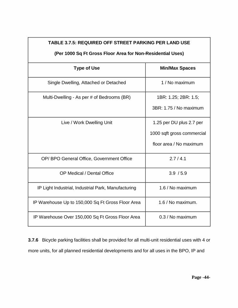
3.7.5 Minimum and maximum off-street parking spaces for various land uses are as
follows. (Spaces for permitted uses in the BPO, IP and OP districts is per 1000 square
feet of gross floor area of all occupiable structures on site.)
Page -44-
TABLE 3.7.5: REQUIRED OFF STREET PARKING PER LAND USE
(Per 1000 Sq Ft Gross Floor Area for Non-Residential Uses)
Type of Use Min/Max Spaces
Single Dwelling, Attached or Detached 1 / No maximum
Multi-Dwelling - As per # of Bedrooms (BR) 1BR: 1.25; 2BR: 1.5;
3BR: 1.75 / No maximum
Live / Work Dwelling Unit 1.25 per DU plus 2.7 per
1000 sqft gross commercial
floor area / No maximum
OP/ BPO General Office, Government Office 2.7 / 4.1
OP Medical / Dental Office 3.9 / 5.9
IP Light Industrial, Industrial Park, Manufacturing 1.6 / No maximum
IP Warehouse Up to 150,000 Sq Ft Gross Floor Area 1.6 / No maximum.
IP Warehouse Over 150,000 Sq Ft Gross Floor Area 0.3 / No maximum
3.7.6 Bicycle parking facilities shall be provided for all multi-unit residential uses with 4 or
more units, for all planned residential developments and for all uses in the BPO, IP and

Page -45-
OP districts. All facilities shall be designed to allow the user to lock the bicycle frame and
wheels.
3.7.7 Bicycle parking in multi-unit and planned residential sites shall include at least 1
bicycle parking space per residential unit or a garage in lieu of the parking space.
3.7.8 Uses in the BPO, IP and OP districts shall provide at least 2 bicycle parking
spaces or ½ space per 1000 square feet of gross floor area, whichever is greater.
3.7.9 Any area designated for bicycle parking shall be convenient, secure and lighted,
shall be at least 6 feet long by 2 feet wide by 7 feet high (if height is restricted), shall
include a paved maneuvering area at least 5 feet wide and paved access to the public
right of way and shall be identified with signage.
3.8 Required Public Facilities and Undergrounding
3.8.1 The City’s public water supply shall be extended if necessary and at the property
owner’s expense so as to be available at the property line of each lot in a pressure and
volume sufficient for the intended land use and construction type and use, as determined
by the City’s water provider, and shall be extended to the boundary/ies of adjacent
property/ies unless the water provider deems such extension to be not necessary or
desirable.

Page -46-
3.8.2 The City’s sanitary- and storm sewerage system shall be extended if necessary
and at the property owner’s expense so as to be available at the property line for any
proposed land use for which the standards of the Clean Water Services (CWS) district
require connection. All such faciilties shall be constructed to CWS standards. No land
division or land use for which City’s approval is required shall use septic tanks or similar
facilities for private sanitary sewage disposal. Facilities for storm water detention shall be
determined by CWS and the City.
3.8.3 Electricity, natural gas, and telephone and telecommunications supply lines shall
be placed underground within the boundaries of a site and along those portions of public
right of way that abut the site and shall otherwise be designed, constructed and placed
according to the standards and requirements of the utility provider.
3.8.4 The City Engineer may allow payment of a fee in lieu of undergrounding the
utilities existing or to be located in the public right of way abutting a site when the City
Engineer determines, as to the site of a particular land use or land division, that:
3.8.4.1 placement or relocation of utilities underground along the public right of way
at that location would conflict with other underground utilities already in place; or,
3.8.4.2 a public project to place utilities underground along the right of way at that
location has been planned and budgeted to commence within the following year; or,
3.8.4.3 the scale of development at the site is such that to underground utilities
along abutting public right of way at only that location would be unreasonably expensive

Page -47-
compared to the economies of scale that would result from a larger scale utility
undergrounding project that the City may undertake using funds collected as fees in lieu.
3.8.5 The City Engineer with the advice of the utility providers shall determine the
amount of a fee in lieu of undergrounding calculated as the average cost to perform the
work city-wide for all locations where utilities are not yet underground and expressed as a
cost per lineal foot times the lineal footage of public right of way abutting the site of the
land use or land division.
3.8.6 Nothing in this section shall be deemed to allow the construction, placement or
maintenance of aerial utilities on any portion of the property for which the City has
approved a land use or land division that does not abut public right of way.
3.8.7 The City shall keep all moneys collected as fees in lieu of undergrounding and any
interest earned on those moneys in an encumbered account to be used only for utility
undergrounding work at such locations as the City chooses in its sole discretion.
3.9 Street Design.
3.9.1 The standard width of right of way of all public streets to be constructed or
reconstructed to serve a land division (other than a property line adjustment), applicable
unless the City approves an alternate street design, shall be:
3.9.1.1 Major arterial, 80 feet, 60 feet paved;

Page -48-
3.9.1.2 Minor arterial, 60 feet, 46 feet paved;
3.9.1.3 Major collector, 60 feet, 42 feet paved;
3.9.1.4 Neighborhood collector, 50 feet, 32 feet paved;
3.9.1.5 Local street and cul-de-sac, 40 feet, 26 feet paved;
3.9.1.6 Cul-de-sac turnaround, 45 foot radius, 38 feet paved.
3.9.2 Street Configuration. All streets, sidewalks, bicycle lanes and gutters, street lights,
street name signs and traffic control devices shall be aligned, contoured, drained, and
constructed according to uniform standards that the City shall adopt from time to time on
the advice of the City engineer.
3.9.2.1 A new street that extends an existing street shall align with an existing
centerline to the maximum extent practicable. No two streets shall be offset at a “T”
intersection by less than 100 feet.
3.9.2.2 A new street shall extend to the boundary of the land division when
necessary for future connection to adjacent property as shown in the City’s transportation
systems plan.
3.9.2.3 The City may approve a half-street to serve a land division when the City
finds that to comply with the City’s transportation systems plan, the remaining half should
be constructed on adjacent property at the time the adjacent property is developed or
divided.
3.9.2.4 The maximum length of a cul-de-sac shall be 300 feet measured from the
nearest edge of the curb return of the intersecting street.

Page -49-
3.9.2.5 A proposed cul-de-sac of 150 feet or longer shall provide for a bicycle and
pedestrian connection from the end of the cul-de-sac to one or more local streets, if any,
that abut the land division.
3.9.2.6 The street grade shall not exceed 6 percent on an arterial, 10 percent on a
collector and 12 percent on any other street. A curve shall have a center line radius not
less than 300 feet on a major arterial, 200 feet on a minor arterial and 100 feet on any
other street.
3.9.2.7 A land division adjacent to railroad right of way shall provide for a street or
streets parallel to that right of way at a distance from same that allows for approach
grades to any future crossings and for landscaping to screen that right of way.
3.9.2.8 A land division or planned development in the BPO, IP, or OP district shall
provide for one or more alleyways at least 20 feet wide and with radii at intersections of at
least 12 feet for access to parking and loading areas.
3.9.2.9 A new street shall be oriented generally east-west to the maximum extent
practicable to provide for solar access.
3.9.2.10 The maximum length of a block is 1200 feet unless adjacent to an arterial or
unless the existing local street pattern or topography require a different length.
3.9.2.11 The preferred minimum length between intersections along an arterial is
1800 feet.
3.9.2.12 A land division traversed by a water course, drainage way, channel or
public or private street shall include an easement to the public for storm water
conveyance conforming to CWS’ current design and construction standards.

Page -50-
3.9.3 Bicycle and Pedestrian Access. All streets and access ways provided in any new
land division shall provide reasonably direct routes for pedestrian and bicycle travel in
areas where such travel is likely if connections are provided and that avoids levels of
motorized traffic that might interfere with or discourage pedestrian or bicycle travel.
3.9.3.1 Bicycle and pedestrian routes shall connect new land divisions, multi-
dwelling and planned residential developments to adjacent residential areas, transit stops
and to schools, shopping and employment areas located up to ½ mile away.
3.9.3.2 Bikeways shall be required along arterials and major collectors. Sidewalks
shall be required along all arterials, collectors and local streets.
3.9.3.3 On-site facilities shall be provided for safe and convenient pedestrian and
bicycle access from land divisions, multi-unit and planned residential developments, and
by identified access ways in land uses in the BPO, IP and OP districts.
3.9.3.4 All developments in the BPO, IP and OP districts shall provide internal
pedestrian circulation through clustering of buildings, construction of identified
accessways and walkways and similar techniques.
3.9.3.5 All developments in the BPO, IP and OP districts that abut an arterial or
collector along which a major transit stop exists or is feasible shall provide walkways
connecting building entrances to that street and shall provide pedestrian access to
adjoining properties except where such a connection is impracticable as provided for in
OAR 660-012-0045(3)(b)(E) as amended and renumbered from time to time.

Page -51-
3.9.4 Alternate Street and Paved Surface Designs to Protect Natural Resources .
The City may allow an application for a land division or land use that includes alternate
street designs and dimensions intended to minimize impervious surfaces and to
otherwise manage storm water runoff quality and quantity so as to protect natural
resources. The City may consider proposals for alternate designs for streets, access
ways and parking areas as part of its review of any land use or land division that includes
new public or private paved rights of way or access ways or paved areas for motor
vehicle parking.
3.9.4.1 Design Standards. An application for use of alternate street and paved
surface designs shall address the following standards and objectives:
3.9.4.1.1 On-street parking limited to one side so as to reduce street width to the
minimum required for emergency vehicle access;
3.9.4.1.2 Use of pervious paving material with provision to assume or share the cost
to maintain same if used for public right of way;
3.9.4.1.3 Use of drainage swales along the border of paved surfaces including
planted materials that may serve to filter or transpire toxic or hazardous materials
contained within storm water runoff;
3.9.4.1.4 Use of storm water detention ponds (but not situated within the front
setback) or underground storm water detention or treatment;
3.9.4.1.5 Preservation of existing trees and placement of new trees to screen motor
vehicle rights of way from adjacent uses by use of alternate sidewalk designs or

Page -52-
dimensions or placement of sidewalks on surface easements instead of within the
boundaries of public right of way;
3.9.4.1.6 Shared parking as between adjacent properties where the applicant shows
that the minimum off street parking required by this Code is available for use by each
property owner during normal hours of operation for each property;
3.9.4.1.7 Additional landscaping within and on the borders of paved parking areas
especially when adjacent to areas having significant natural resources.
3.9.4.2 Any alternate street or paved surface design that the City may allow shall
conform to the current design and construction standards of CWS.
3.9.4.2.1 The City shall not approve an alternate street or paved surface design that
includes a storm water detention pond to be located within the front setback of any
property unless the applicant shows that no other location and no other method of storm
water detention is feasible.
3.9.5 Private Streets. The City may allow private streets if designed and constructed to
standards published by the City Engineer.
3.9.5.1 Private streets providing access to more than six dwelling units may be
permitted only within Planned Residential Developments, mobile or manufactured home
parks and multi-dwelling residential developments.
3.9.5.2 The City shall require adequate provisions for maintenance and repair of
private streets by covenants or other means in a form approved by the City Attorney.

Page -53-
3.10 Protection of Transportation Facilities. An applicant for proposed development
in any zoning district shall submit a Traffic Impact Analysis prepared by a registered
professional traffic engineer when the proposed development may reasonably be
expected to generate more than 200 vehicle trips per day or when the City determine that
the application if approved may have a “significant effect” on an existing or planned
transportation facility as that term is defined in OAR 660-012-0060.

Page -54-
4 APPLICATION AND APPROVAL CRITERIA FOR
LAND USE, REZONE AND TEXT AMENDMENT
4.1 Scope. This Chapter sets out the requirements for an application for certain land
uses, for a revision to the zoning map and for an amendment to this Code (a “text
amendment”). Those submittals when received shall be reviewed by the City as set out in
Chapter 9, Procedures, and shall be decided based on compliance with the standards set
out this Code as to permissible land uses in various zoning districts, the site and other
design regulations applicable to those uses, tree protection and sign regulation, the
supplemental regulations for particular categories of uses (if applicable) and any other
criteria set out in this Chapter.
4.2 Application Requirements- BPO, IP, MDR, MDDO, OP, PRD Uses. In addition
to any other submittals required by this Code, an application for a business park overlay
zone change, for any development in the IP and OP districts, for a multi-dwelling
residential development or for a planned residential development shall include, with all
plans for the proposed use(s) to show date, north point and scale:
4.2.1 The person’s ownership- or other interest in the property that is the subject of the
application; or, If the applicant is not the owner, proof that the applicant is authorized to
act on the owner’s behalf;
4.2.1.1 A purchaser under a land sale contract and a private or public entity that
gives notice of intent to acquire by eminent domain shall be deemed to have an
ownership interest in property for purposes of this section.

Page -55-
4.2.2 The location of the subject property by section, township and range and legal
description and by a vicinity map showing the relative position of the property to adjacent
properties and to zoning districts within 1000 feet of the proposed land use or rezone;
4.2.3 Existing contour lines related to an established bench mark or similar datum
acceptable to the City engineer, with intervals shown at a minimum of 2 feet for slopes up
to 5 percent and at a minimum of five feet for slopes over 5 percent, and a preliminary
grading plan showing any proposed changes to existing grade, with intervals shown at a
minimum of ½ foot for all such changes;
4.2.4 The location and dimension of all existing and proposed private and public rights of
way, access and utility easements, proposed widths, names, approximate grades and
approximate radii of curves, landscaped areas, and any non-buildable or otherwise
(proposed) dedicated tracts of land adjacent to or within the property boundaries (if in
riparian areas, shown to comply with CWS standards for determining the boundaries of
such areas);
4.2.5 Proposed access, parking, loading and circulation patterns and dimensions for
vehicles and pedestrians;

Page -56-
4.2.6 Existing uses of the property including all existing structures and, if applicable, the
location, dimensions and setback of proposed structures;
4.2.7 All trees existing on the property that are nominally subject to the provisions of this
Code as to tree preservation, including the type and location of trees to be preserved, and
a landscape plan to show the location, size and species of any plant materials to be
added to the site;
4.2.8 Other natural features such as flood plains, wetlands, riparian areas, upland
wooded corridors, slopes that are 25 percent or greater, and all other data needed or
desired to address Metro Urban Growth Management Functional Plan Title 3 (Water
Quality, Flood Management and Fish and Wildlife Conservation);
4.2.9 The location and direction of existing water courses and “water quality sensitive
areas” as defined by Clean Water Services (CWS) on site or within 200 feet of any point
on the site, together with a copy of CWS’ approved pre-development site assessment (as
required by the current version of CWS’ Design and Construction Standards for Sanitary
and Surface Water Management);
4.2.10 The location and dimensions of any land that may be platted and restricted as a
non-buildable tract or dedicated to the public in fee or as a conservation- or similar

Page -57-
easement, with the location and dimensions of any such tract in a riparian area to
conform to CWS’ current design and construction standards;
4.2.11 Site data listing square footage and percentage of land area allocation to structure
coverage, landscaping, and parking and access ways, including the number of proposed
parking spaces and restricted spaces;
4.2.12 Architectural drawings showing building elevations, height and width, building
materials, color and type, and the name(s) of the persons who prepared the drawing(s);
4.2.13 If the application if approved may result in additional motor vehicle trips to and
from the property so as to affect the level of service of public rights of way or of an
intersection or other transportation facility lying within 1/2 mile of any point on the
property, a traffic impact analysis by a registered traffic engineer;
4.2.14 An assessment of the effect of the proposal on public facilities and services,
including but not limited to a traffic impact analysis prepared by a licensed traffic
engineer, and other information to show how the applicant proposes to ensure that
adequate public transportation, storm and sanitary sewerage and drainage and public
water facilities and services will be available at the site if developed;

Page -58-
4.2.15 For any application that constitutes “development” as defined by Clean Water
Services (CWS), a site assessment or a service provider letter or both from CWS to show
any site layout and design detail and public improvements that CWS proposes as
conditions of City’s approval.
4.2.16 Community Development Conference. For any development application other than
a land division, a rezone or a text amendment, the applicant shall first conduct, before
the City deems the application complete, a community development conference to hear
all interested persons as to their potential concerns with the proposed land use and to
address those concerns prior to submitting the application to the City.
4.2.16.1 The applicant shall send at least 20 days’ notice of a community
development conference to all persons who own property within 300 feet of any point on
the proposed development site. The conference shall be scheduled for an evening or
weekend at a place within the City or nearby and shall be open to the public. The notice
shall list the criteria for review and approval of the proposed land use as determined by
the City. City staff shall attend the conference and keep minutes of the discussion. The
conference shall be at the applicant’s sole initiative and expense including the expense of
the City’s staff support for the conference.
4.2.17 No application shall be complete unless and until the applicant undertakes by a
signed writing to pay all of the City’s costs and professional fees incurred to review the
application and pays the City a deposit of $500 against those fees and costs.

Page -59-
4.2.17.1 No land use approval and no building permit that is conditioned on a land
use approval shall be valid unless and until the City’s costs and fees incurred to review
the land use application are paid in full.
4.3 Approval Criteria - MDDO, MDR and PRD Land Use Application. The City may
approve an application for a residential land use in the MDDO and MDR districts and an
application for a Planned Residential Development if it finds that:
4.3.1 the proposed use is permitted in the underlying zoning district; whether permitted
outright, with conditions or with the concurrent grant of a variance;
4.3.2 the site as developed will conform to the site design standards of this Code or will
conform upon compliance with conditions of approval or with the concurrent grant of an
adjustment or variance, or both, and the City finds that compliance with the condition(s) of
approval is feasible;
4.3.3 all public improvements necessary to serve the development are or will be
available prior to the issuance of any building permit;
4.3.4 a residential development in the NR or NRO district or a Planned Residential
Development in the SDR or MDR district provides for dedication to the public or other

Page -60-
means to preserve natural resource areas, with or without the concurrent grant of a
density transfer within the boundaries of the site;
4.3.5 the proposal complies with the tree preservation provisions of this Code;
4.3.6 the application if approved, with conditions of approval as may be necessary, shall
not degrade the level of service of transportation facilities serving the development; and,
4.3.7 the proposed use substantially complies with the housing policies of the City’s land
use comprehensive plan.
4.4 Approval Criteria - BPO, IP, OP Land Use Application. The City may approve
an application for a land use in the BPO, IP or OP district if it finds that:
4.4.1 the proposed use is permitted in the underlying zoning district; whether permitted
outright, with conditions or with the concurrent grant of a variance;
4.4.2 the site as developed will conform to the site design standards of this Code or will
conform upon compliance with conditions of approval or with the concurrent grant of an
adjustment or variance, or both, and the City finds that compliance with the condition(s) of
approval is feasible;
Page -61-
4.4.3 all public improvements necessary to serve the development are or will be
available prior to the issuance of any building permit;
4.4.4 the application if approved, with conditions of approval as may be necessary, shall
not degrade the level of service of transportation facilities serving the development;
4.4.5 the proposed landscaping for the site shall be professionally designed, furnished
and perpetually maintained and there is adequate provision for such perpetual
maintenance, and that the application complies with the tree preservation provisions of
this Code; and,
4.4.6 the proposed building elevations, exterior materials, colors and finishes and other
aspects of the exterior appearance of the site as developed substantially comply with the
community appearance policies of the City’s comprehensive land use plan.
4.5 Application Requirements - Land Uses in NR and NRO Districts. An applicant
for a use permitted in the NR or NRO district for a site lying wholly or partially within a
Flood Management Area shall submit the following in addition to any submittals required
for a land use application in the underlying zoning district:

Page -62-
4.5.1 Plans drawn to scale and in triplicate prepared and stamped by a registered
professional engineer qualified in hydrology showing the nature, location, dimensions,
elevations and topography of the site
4.5.2 The location of existing and proposed structures on the site;
4.5.3 Existing and proposed fill areas, their relation to the location of the stream channel
and proposed methods for controlling erosion;
4.5.4 Documentary and any other evidence to show whether and to what extent the site
lies above the high water mark of the flood plain as shown on the City’s current adopted
flood plain map.
4.6 Approval Criteria - Land Uses in NR and NRO Districts. The City may allow a
proposed land use in the NR or NRO district if it finds, in addition to any other criteria for
approval of such a use provided in this Code, that:
4.6.1 Any proposed improvement will not change the flow of flood waters during future
flooding such as to compound flood hazards; and,

Page -63-
4.6.2 No proposed structure, fill, storage or other use shall reduce the capacity of the
Flood Management Area, nor raise the flood surface elevation on any adjacent property,
nor create a foreseeable hazard to the public health, safety and welfare.
4.6.3 The proposed use shall not adversely affect runoff, erosion, ground stability, water
quality, ground water level or flooding and the site can support the proposed
improvement(s) without creating a risk of damage to adjacent property.
4.7 Conditional Use Application. An application for a land use described in this
Code as a conditional use shall address the following criteria for approval:
4.7.1 The size, shape, location, topography, natural features and existing improvements
on site are suitable for the proposed use;
4.7.2 There are or will be adequate public and private infrastructure available to the use
by the time that the use is to be placed in service or occupied;
4.7.3 The use will not alter the character of the surrounding area in a way that
substantially limits, impairs or precludes use of surrounding properties for the primary
uses allowed for those properties in that zoning district.

Page -64-
4.7.4 The City may impose any and all conditions of approval of a conditional use that
would allow the City to find that. An application for a conditional use shall demonstrate
that the application, if granted, will meet the following additional criteria for approval with
conditions if feasible and necessary to meet the critereria:
4.7.4.1 the conditions will allow the proposed use to meet the intent of the
comprehensive land use plan and of this Code for that zoning district; and,
4.7.4.2 the use if allowed will not create a demand on transportation- or other
infrastructure that is disproportionate to uses permitted outright in that zoning district; and,
4.7.4.3 the proposed development is compatible with the size, dimensions,
configuration and topography and natural and man-made features of the site; and,
4.7.4.4 the location, size and functioning of the proposed development shall be
reasonably compatible with and not unreasonably impair the use and enjoyment of
surrounding properties nor limit the appropriate development of those properties.
4.7.5 The City may approve a conditional use with one or more of the following
conditions, among others:
4.7.5.1 Site and lot dimensions larger than the minimum requirements;
4.7.5.2 Site or architectural design features intended to limit adverse environmental
affects, including the preservation of existing trees and other natural resources;
4.7.5.3 Limits on the number and location of vehicular accesses to the site;

Page -65-
4.7.5.4 Street dimensions larger than standard to accommodate the vehicle traffic
that the use may generate, and dedications and improvement of public right of way that is
roughly proportional to the traffic impact;
4.7.5.5 Off-street parking and loading spaces greater than the minimum required;
4.7.5.6 Limitations on signage;
4.7.5.7 Limits on building dimensions and location to reduce obstructions of views,
light and air to surrounding properties, including larger setback areas;
4.7.5.8 Sight obscuring fencing and landscaping to reduce noise, light and other
environmental impacts on surrounding properties;
4.7.5.9 Limits on hours, days, place and manner of operation;
4.7.5.10 Conditions that limit future alterations and additions to the site.
4.7.5.11 Conditions to minimize impacts and protect transportation facilities,
corridors or sites.
4.8 Rezone Application. The City may approve an application to rezone property by a
quasi-judicial or a legislative process as the City determines.
4.8.1 An applicant for a quasi-judicial rezone shall submit, in addition to the submittals
generally required for land uses and rezones set out in this chapter, a narrative
statement and evidence that addresses the following criteria for approval:
4.8.1.1 The public interest to be served by the rezone;

Page -66-
4.8.1.2 That the public interest is best served by a rezone of the applicant’s site
compared to alternative sites already zoned for the use(s) allowable if the property were
rezoned;
4.8.1.3 That the rezone is consistent with the City’s comprehensive land use plan;
4.8.1.4 That the rezone if approved will not substantially limit, impair or preclude
allowed uses of surrounding properties;
4.8.1.5 That public and private infrastructure is or will be available to serve the
allowable uses of the site if the rezone is approved; and, if applicable,
4.8.1.6 That the condition of the site or surrounding properties or that societal
circumstances generally have changed since the last amendment of the City’s
comprehensive land use plan such that the rezone is appropriate.
4.8.2 An application to rezone property in the IP or OP district to any zone other than the
BPO zone may be approved only if the City finds substantial evidence to show that the
rezone if granted shall not reduce the potential number of persons who may be employed
in those areas for which Metro requires that the City preserve opportunities for
employment.
4.9 Text Amendment Application.
4.9.1 The City may approve an application for a text amendment to this Code (other
than a rezone) by a quasi-judicial or a legislative process as the City determines.

Page -67-
4.9.2 An applicant for a quasi-judicial text amendment shall submit the following in
addition to the submittals generally required for land uses and rezones set out in this
chapter:
4.9.2.1 A narrative stating the purpose of the application;
4.9.2.2 A comprehensive list of all sections of this Code to be amended;
4.9.2.3 If applicable, a graphical or similar depiction of site and design standards,
structural or area dimensions or layout, or other visual effects that would result from the
amendment if approved;
4.9.2.4 A list of all statewide planning goals and other administrative rules, Metro
planning requirements, and City comprehensive land use plan provisions that the
applicant deems relevant to the application and a narrative as to how the application is
consistent with those other enactments; and,
4.9.2.5 A narrative description of how the application if approved would serve the
public interest.
4.9.3 The criteria for decision on a text amendment are set out In Chapter 9 of this Code
relating to the Type 4 (Legislative) process.
4.10 Text Amendment or Rezone Affecting Transportation Facility. When a
proposed text amendment or rezone may significantly affect an existing or planned
transportation facility (as that phrase is defined in Oregon law), the City may require the

Page -68-
applicant to submit an independent, professional traffic study to address whether approval
of the amendment or rezone requires measures to assure that the land uses that would
be allowed by such approval are consistent with the identified function, capacity, and
performance standards of that facility.
4.10.1 The City shall coordinate its determination of whether a text amendment or rezone
may significantly affect such a facility with affected transportation facility and service
providers and other affected local governments.
4.10.2 A text amendment or rezone significantly affects a transportation facility if it would:
4.10.2.1 Change the functional classification of an existing or planned transportation
facility; or,
4.10.2.2 Change standards implementing a functional classification system; or,
4.10.2.3 As measured at the end of the planning period identified in the City’s
adopted transportation system plan:
4.10.2.3.1 Allow land uses or levels of development that would result in types of travel
or access that are inconsistent with the functional classification of an existing or planned
transportation facility; or,
4.10.2.3.2 Degrade the performance of an existing or planned transportation facility
below the minimum acceptable performance standard such that it would not meet the
performance standards identified in the transportation system plan or comprehensive land
use plan; or,

Page -69-
4.10.2.3.3 Degrade the performance of an existing or planned transportation facility
that is otherwise projected to perform below that minimum acceptable performance
standard. not to meet the performance standards identified in the transportation systems
plan or comprehensive land use plan.
4.10.3 When the City determines that a text amendment or rezone would have such a
significant effect, the City may take any of the measures to remedy that effect as are
provided in Oregon Administrative Rule OAR 660-012-0060 as amended or renumbered
from time to time, including but not limited to imposing conditions of approval on the text
amendment or rezone requiring transportation system management measures, demand
management or minor transportation improvements.

Page -70-
5 TREE PROTECTION
5.1 Scope Every tree within the City with a diameter of 5 inches or greater shall be
preserved and protected as required by this Chapter. A tree with a single trunk shall be
measured at 4.5’ above grade, otherwise known as “diameter at breast height” and
designated hereafter as DBH. For a tree with multiple main stems digressing at less
than 24 inches above grade the measurement will be determined by the greater
of the measurement of the trunk at the point of digression or the sum of the diameter of
all stems measured 6 inches above the point of digression. A tree that has been
reduced to a stump shall be measured across the top of the trunk. For purposes of this
Chapter 5, to “Cut” a tree means to fell or remove a tree or to do anything that
has the natural result of causing the death or substantial destruction of a tree.
5.2 Tree Care Standards. No person other than the property’s owner or a tree care
provider licensed and bonded as such shall perform tree preservation, tree protection,
tree maintenance or tree removal. All such work shall be done in accordance with ANSI
A-300.
5.3. Application Required. No person shall Cut a tree without first submitting an
application, paying the applicable fees, obtaining a City permit and complying with all
terms and conditions of the City permit. The provisions of this Chapter including
the requirement for a City Permit shall control over any authority to Cut a tree

Page -71-
purportedly granted by any other federal, state or local authority.
5.3.1 In an emergency wherein in a tree presents imminent danger to person or
property, the property owner shall report the action to the City within 48 hours or the first
work day following a weekend or holiday. The property owner shall also submit the
required application without charge and provide documentation supporting the imminent
danger presented by the tree sufficient to satisfy exemption from the standard permit
requirements of this Chapter.
5.3.1.1 If it should be found by the Planning Commission that the supporting
documentation does not support a finding that the tree presented an imminent danger,
it shall be deemed a violation of this Chapter.
5.3.2 Every application to remove a tree(s) shall provide:
5.3.2.1 A diagram of the lot drawn to approximate scale showing the number,
size, species and location of all trees on the property and the tree(s) proposed to be
Cut.
5.3.2.2 Proof that the topography of the property is such that to cut the tree will
not adversely affect, soil retention, stability of earth, flow of surface water, protection of
nearby trees, windbreaks and a desirable balance between shade and open space.
5.3.2.3 Evidence that to Cut the tree will not materially affect the preservation of
an upland wooded corridor or stream side vegetated corridor as identified in the City’s
Comprehensive Land Use Plan.

Page -72-
5.3.2.4 When mitigation is anticipated, a mitigation plan showing location and
species of tree or trees to be planted subject to the standards set forth in the section
applicable to the permit type, or tender of payment of the in lieu fee to the mitigation
fund.
5.4 Application Types on Developed Residential Lots. An applicant seeking to
Cut a tree or trees on a developed lot shall apply separately for each tree to be Cut
under one of the following applications types:
5.4.1 Type “A” Permit. Trees that are dead or diseased shall be reviewed and
approved under a Type 1 process. In instances when it cannot be determined readily
that a tree is diseased beyond recovery, or that measures cannot be taken to
restore the tree’s health, approval may be conditioned on an evaluation by a certified
arborist or appealed to the Planning Commission upon payment of the appeal fee. For
an approved Type “A” permit no mitigation is required.
5.4.2 Type “B” Permit. Trees that are dangerous or potentially destructive to
public or private property may be approved by a Type 1 process. When it cannot be
determined readily that a tree poses a potential for being dangerous or destructive,
approval may be conditioned upon evaluation by a certified arborist or appealed to the
Planning Commission upon payment of the appeal fee. For an approved Type “B
permit no mitigation is required.

Page -73-
5.4.3 Type “C” Permit. Trees required to be removed for the purpose of
enlarging the footprint of a structure, adding a deck, patio, or other building structure on
already improved lots may be approved by a Type 1 process. A Type “C” permit will
only be issued subsequent to the approved building permit.
5.4.4 Type “D” Permit. A tree less than 5” DBH does not require a permit for
removal. A tree between 5” and 10” DBH not permitted for removal under any other
permit type may be removed at the discretion of a property owner under a Type 1
process. Approval shall be conditioned upon confirmation that the tree to be removed
does not exceed the maximum DBH. No more than one tree shall be permitted for
removal under a type “D” permit in any 24 month period. No mitigation shall be
required.
5.4.5 Type “E” Permit. Trees measuring 10” DBH or greater and not eligible for
any other permit type, including Type “D,” shall be subject to permitting with Planning
Commission approval under a Type 2 process. For an approved Type “E” Permit
mitigation shall be provided as set forth in Section 5.5. Under certain circumstances,
the Planning Commission may require mitigation exceeding that required in
Section 5.5, but not less.
5.5 Mitigation Standards on Developed Residential Lots. At such time as

Page -74-
mitigation is required for any permit designated as a Type “A” through Type “E” the
standards shall be as follows:
5.5.1 The minimum size for a tree planted as mitigation shall be 2” diameter
when measured from the top of the root ball for deciduous trees. Evergreen trees shall
be a minimum of 6’ tall measured from the top of the root ball, excluding the leader.
5.5.2 The specific species of a tree planted for mitigation shall be at the owner’s
discretion, but must be such that it contributes significantly to the future maintenance of
the canopy in Durham. The permit decision making authority shall have the right to
reject as mitigation any proposed tree that does not meet the general intent of Chapter
5 of the Development Code.
5.5.3 Mitigation trees shall be planted within 6 months of that date of permit
approval. The City Administrator may approve a one-time extension of 60 days.
5.5.4 A mitigation tree shall be planted so as to insure that the tree grows to
maturity.
5.5.5 The recipient of a tree removal permit shall request an inspection of the
completed mitigation plan upon completion, but no later than 6 months following permit
issuance or a subsequent 60 day extension thereof.

Page -75-
5.5.6 Any mitigation planting failing within 2 years of the time of the first
inspection by the City shall be replaced at the owner’s expense and the City shall be
notified of such replacement at the time of planting.
5.5.7 A final inspection shall be requested within 60 days of the second
anniversary of the date of the last planting and the permit shall not be considered
finalized until such time as a final inspection is conducted and found to be in conformity
with the mitigation standards.
5.5.8 The City shall make every reasonable effort to notify the property owner
when the final inspection is due, but it shall be the responsibility of the property owner to
contact the City.
5.6 Type “F” Permit. A permit issued for removal of a tree(s) 5” DBH or
greater in developed commercial and industrial zones shall be designated a Type “F”
Permit and be subject to review and approval by the Planning Commission under a
Type 2 process. Mitigation shall be required per the conditions set forth in section 5.8.
5.6.1 Removal of a tree in the commercial and industrial zones shall not qualify
for any other permit type.

Page -76-
5.7 Type “G” Permit. For Previously Undeveloped Property.
5.7.1 Tree Preservation Plan. The City’s approval of a land division-, land use-
or building permit issued for vacant property shall be deemed to obligate the property
owner to use best efforts to preserve all existing trees on the site to be divided or
developed. Separate Type “G” permit applications shall be submitted for a land division
and installation of required infrastructure as well as for installation of utilities and
structural building permits on each lot at the time the lot applies for a building permit.
The applicant shall submit with the initial application a tree preservation plan prepared
by a certified arborist with a narrative as to how the plan will effect tree preservation.
5.7.2 An applicant shall attempt to preserve existing trees on a site by varying
the site design, as provided for elsewhere in this Code, and by the following means,
whichever are applicable:
5.7.2.1 Specific measures for tree preservation and protection during all phases of
construction, including excavation, grading and filling, repair and removal of trees,
pruning and structural support, fertilization and aeration;
5.7.2.2 Use of tree protection zone or construction zone tape with tree fencing;
5.7.2.3 All tree related decisions and activity to be approved by the City’s arborist;
5.7.2.4 All preserved tree health determinations, other than construction damage,
to require core samples or other non-harmful procedures;
5.7.2.5 Authorize the City to stop work for any violation of the approved plan;

Page -77-
5.7.2.6 Require the contractor to acknowledge the approved tree protection plan
in writing prior to any on-site tree removal, with a copy of same provided to the City.
5.7.2.7 Repair any damage to a preserved tree in a timely manner.
5.7.2.8 Employ an Arborist to prevent harm from construction activity to a tree to
be preserved on the site;
5.7.2.9 Coordinate the project grading with the City’s Arborist to identify possible
preservation of additional trees not shown on the application;
5.8 Mitigation Required. Removed trees shall be replaced with mitigation
trees to the extent that at maturity they equal the canopy being removed or mature
canopy coverage equivalent to 35% of the square footage of the lot, whichever is less.
Mature canopy coverage shall be as set forth on the City’s tree list based on the tree
species, or as otherwise determined by the City Administrator.
5.8.1 Preservation of existing trees in good condition, suitable for preservation
and of appropriate species, shall receive a 200% credit based on their existing canopy
area. Planting of native species shall receive a credit of 125% of mature canopy.
(Example: A 10,000 s.f. lot would require 3,500 s.f. of canopy. An existing Black
Hawthorne has 314 s.f. of existing canopy. This property would receive a credit of 628
s.f., leaving 2,872 s.f that will need to be mitigated for with new plantings.)
5.8.2 Mitigation trees shall be selected from any of the tree lists maintained by

Page -78-
the City, excepting nuisance trees, unless otherwise approved by the City
Administrator.
5.8.3 The minimum size for a tree planted as mitigation shall be 2” diameter when
measured from the top of the root ball for deciduous trees. Evergreen trees shall be a
minimum of 6’ tall measured from the top of the root ball, excluding the leader.
5.8.4 Mitigation trees shall be located as follows 5.8.4.1 Trees categorized as small on the City’s tree list shall be spaced no closer
than 15’ on center from other trees and no closer than 10’ from the face of any
structure.
5.8.4.2 Trees categorized as medium on the City’s list shall be spaced no closer
than 20’ on center from other trees and no closer than 10’ from the face of any
structure.
5.8.4.3 Trees categorized as large on the City’s tree list shall be spaced no closer
than 30’ on center from other trees and no closer than 15’ from the face of any
structure.
5.8.4.4 No tree shall be placed less than 3’ from any hard surface. 5.8.5 Replacement of one or more trees when required as a condition of a land
division or land development approval shall be complete within 6 months after the
approval is final. The City may grant a 60 day extension if the City finds abnormal

Page -79-
weather conditions require delay. Additional time beyond the 60 day extension shall
be subject to Planning Commission approval.
5.8.6 Trees removed for the purpose of installation of infrastructure upon a
division of land may be mitigated by the developer by planting the required mitigation
trees upon any lot in the division. Such trees will be required to be planted outside the
anticipated footprint of any future structure or within required structural setback areas.
At such time as building occurs, the builder/owner of the lot shall receive a credit of
100% of mature canopy based on the species planted.
5.8.7 When an improved site cannot accommodate the required number of
replacement trees the City may require the applicant to pay to the City a fee in lieu of
replacement. The fee in lieu shall be in amount set by resolution of the City Council
and shall be based upon the percentage of mature canopy not recovered through
mitigation planting.
5.9 Type “H” Permit. Preserved Trees. A tree initially designated to be
preserved in the tree preservation plan that dies prior to 2 years after project completion
shall be replaced by the property owner. The Planning Commission shall determine the
minimum size, but in no case shall the replacement tree be less than 2.5” DBH and of a
variety expected to provide the canopy coverage at maturity of the tree being replaced.

Page -80-
5.9.1 It shall be the responsibility of the property owner to notify the City at any
time a preserved tree requires replanting within the 2 year period and to request a final
inspection by the City at the end of the 2 year period.
5.9.2 A tree removal permit issued pursuant to section 5.9 shall not be
considered final until the expiration of the 2 year period in compliance with all
conditions imposed thereon.
5.10 Tree Permit Process. Permit types “A” through “D” shall be reviewed by a
Type 1 process. All other permits for the removal of a tree or trees shall be by a Type 2
process.
5.11 Rights Reserved. For all permit types, the decision making authority
reserves the right to deny a permit, require mitigation or require mitigation beyond the
minimum specified in this ordinance when it is considered in the best interest and
welfare of the community as a whole. Administrative decisions are appealable to the
Planning Commission and Planning Commission decisions may be appealed to the City
Council.
5.12 Determination of Permit Type. Certain trees on developed residential

Page -81-
lots for which the City receives an application for removal may qualify for removal under
more than one permit type. In such cases, the City shall determine the appropriate
permit type.

Page -82-
6 SIGN REGULATION
6.1 Scope. Any sign visible from the public right-of-way is subject to regulation by this
Code. This Code shall apply to the placement of a new sign and major modification or
replacement of an existing sign. Signs are regulated in all zoning districts and as to all
uses of land.
6.1.1 A major modification of an existing sign means a change in dimension, structure
or placement to the extent that any or all of those features of the particular sign(s) are
(now ) subject to the limitations or requirements of this Code.
6.1.2 A sign Signage is not a permitted principal use of property in any zoning district
unless the sign but instead is deemed to be incidental and subordinate to a principal
use that is a permitted use of the property under this Code.
6.2 Prohibited Signage Features. In all zoning districts, no sign shall:
6.2.1 Use internal illumination, a flashing or other intermittent device to display a
message, or rotate, revolve or move;

Page -83-
6.2.2 Use external illumination that generates glare that disrupts the vision of motorists
on adjacent right of way or that exceeds 1 foot-candle as measured at any boundary of
the property on which the sign is located;
6.2.3 Project above the highest point of any building to which the sign is attached;
6.2.4 If freestanding, exceed 5 feet in height above average grade as measured within
a 10 foot radius from the base of the sign;
6.2.5 If freestanding, exceed 5 feet above the height of public right-of-way abutting the
property if the latter is more than 2 feet above average grade at the base of the sign as
measured in subsection 6.2.4 above;
6.2.6 Stand less than 5 feet from a property line as shown in deed records;
6.2.7 Stand within or project into any portion of the public right-of-way, except for:
6.2.7.1 A traffic control device authorized by the applicable road authority;
6.2.7.2 An official street name sign;
6.2.7.3 A sign designating public transit stops;
6.2.7.4 A directional sign to a federal, state, or local government function;
6.2.7.5 A sign identifying a public utility lying in or upon the right-of-way, or a sign
identifying a public telephone.

Page -84-
6.2.8 In all zoning districts, no sign shall have more than 2 display faces nor have any
display face larger than 4 by 6 feet.
6.3 Signs Allowed Without Permit. The following signs may be placed without an
application for and approval of a permit:
6.3.1 A sign in the public right-of-way that is expressly allowed by this Code.
6.3.2 A sign on private property in a residential zoning district that is incidental to an
allowed use of that property (other than a home occupation), limited to 2 such signs at
any one time, each not larger than 8 square feet in area.
6.3.3 A sign placed on a window or door of a structure in a multi-unit residential, OP, IP
or BPO zoning district that identifies the name, address and telephone number of the
property owner or manager and that does not exceed 2 square feet in area.
6.3.4 A sign placed on property in the OP, IP or BPO zoning districts that is not
specifically provided for in a development permit, limited to 4 such signs at any one time,
each not larger than 16 square feet in display area.

Page -85-
6.4 Home Occupation Signs. Upon application the City may approve a permit for a
home occupation sign to be placed on property in a zoning district where a home
occupation is a permitted use if the City finds that the applicant holds a current, valid City
business license for the home occupation and that the property owner if other than the
applicant has approved the proposed sign in writing.
6.4.1 A permitted home occupation sign shall be attached to the residence where the
home occupation exists. No portion of the sign shall be higher than 6 feet above grade,
and the sign shall not exceed 2 square feet in area.
6.5 Signs Requiring Permit - SDR, MDR and MDDO Districts. Upon application the
City may approve a permit for the following signage, in addition to the signage allowed
without a permit, for a permitted use of property in a residential zoning district:
6.5.1 One monument sign that generally identifies the property or subdivision.
6.5.2 A comprehensive sign program for a subdivision or multi-unit residential
development if the City finds that the location, size, design, function and aesthetics of the
signage are compatible with the overall design of the building facade(s) based on the
following:

Page -86-
6.5.2.1 A plot plan showing the proposed location of any freestanding sign, traffic
and directional signs and elevation drawings showing proposed sign size, materials and
colors;
6.5.2.2 Elevation drawings showing proposed wall sign for each building and
showing the proposed area and location on the building facade for each sign identifying
the building occupant(s).
6.6 Signs Requiring Permit - Other Districts. Upon application the City may approve
a permit for the following signage on property within those districts (in addition to the
sign(s) allowed without a permit) in the OP, IP and BPO Districts:
6.6.1 One monument sign that generally identifies the property;
6.6.2 One directory sign per occupiable structure that lists the names and locations of
persons occupying the structure;
6.6.3 One wall sign for each individual person or entity or person that occupies a
structure, identifying the location and entry door of the entity or person, not exceeding 30
square feet in area, not extending more than 15 feet horizontally in either direction from
the centerline of the entry and with dimensions proportional to the building facade on
which the sign is placed.

Page -87-
6.7 Comprehensive Sign Program - OP, IP and BPO Districts. On application the
City may approve a permit for signage in the OP, IP and BPO Districts (in addition to the
signage allowed by this Code without a permit) for a development that comprises more
than one building or that comprises one building larger than 10,000 square feet, if the City
finds that the location, size, design, function and aesthetics of the signage are compatible
with the overall design of the building facade(s) based on
6.7.1 A plot plan showing the proposed location of any freestanding sign, traffic and
directional signs and elevation drawings showing proposed sign size, materials and
colors; and,
6.7.2 Elevation drawings showing the proposed wall sign for each building and
showing the proposed area and location on the building facade for each sign identifying
the building occupant(s).
6.8 Sign Permit Process. An application for a sign permit when a permit is required
by this Code shall be reviewed by a Type 2 process or by the process applicable to the
underlying development with which a sign permit application is included, whichever type
affords the most process.
6.8.1 An application to replace an existing sign that does not include a substantial
change in dimension, location, type or material shall be reviewed by a Type 1 process.

Page -88-
7 SUPPLEMENTAL LAND USE REGULATIONS
7.1 Accessory Dwelling Unit
7.1.1 An Accessory Dwelling Unit (ADU) is allowed in a residential district to create new
housing units while respecting the appearance and scale of single unit detached
residences, to provide additional housing stock with minimal impact on the quality and
character of existing neighborhoods, to allow a mix of housing that responds to changing
family needs and smaller households, and to foster a more efficient use of existing
housing stock and the availability of more affordable housing.
7.1.2 An ADU may be created within or shall share a common wall with the primary
residence. A garage may not be converted to an ADU unless replaced with a new garage.
7.1.3 An ADU shall not be larger than 33 percent of the habitable area of the primary
residence (excludes garage) or 600 square feet, whichever is less.
7.1.4 No more than 2 persons shall reside in an ADU at any time and the primary
residence or the ADU shall be owner-occupied. The City may require the owner of the
primary residence to record a deed restriction on the property to that effect.
7.1.5 The primary entrance to the ADU shall not be newly constructed on the facade of
the primary residence that faces public right of way.

Page -89-
7.1.6 All site design regulations of the zoning district shall apply to the ADU.
7.1.7 An ADU created through the addition of floor area to the primary single family
dwelling shall include the following design features:
7.1.7.1 The exterior finish material must be the same or visually match the
exterior finish material of the primary single family dwelling with respect to type,
size, placement, and color;
7.1.7.2 The siding for exterior walls must be the same or similar material and
color as the primary single family dwelling;
7.1.7.3 The roof pitch must be the same as the predominant roof pitch of the
primary single family dwelling;
7.1.7.4 Trim on edges of elements on the addition must be the same in type,
size, and location as the trim used on the primary single family dwelling;
7.1.7.5 Windows must match those on the primary single family dwelling in
proportion (relationship of width to height), shape and size; and,
7.1.7.6 Eaves must project from the building walls the same distance as the
eaves on the primary single family dwelling.
7.2 Flood Management Area
7.2.1 Scope. These regulations apply to all areas of special flood hazards within the City
as are identified by the Federal Insurance Administration in a scientific and engineering

Page -90-
report entitled “The Flood Insurance Study for the City of Durham,” dated February 18,
2005, with accompanying Flood Insurance Maps, on file at City Hall. No structure or land
shall hereafter be constructed, located, extended, converted, or altered without full
compliance with these regulations. The City of Durham has the primary responsibility for
planning, adoption and enforcement of land use regulations to accomplish proper
management of special flood hazard area [FEMA 44 CFR Part 59.22]
The areas of special flood hazard identified by the Federal insurance Administration
in a scientific and engineering report entitled “The Flood Insurance Study for the City
of Durham” dated November 4, 2016 with accompanying Flood Insurance Maps are
hereby adopted by reference and declared to be a part of this section. The Flood
Insurance Study in on file at Durham City Hall. No structure or land shall hereafter be
constructed, located, extended, converted, or altered without full compliance with
these regulations.
7.2.1.1 An application for development in the floodplain shall be reviewed and
decided by a Type 1 process but for those aspects of the development that are within the
jurisdiction of the City Building Official. A development permit shall be obtained before
construction or development begins within any area of special flood hazard. The permit
shall be for all structures including manufactured homes, as set forth in the
“DEFINITIONS,” and for all development including fill and other activities, also as set forth
in the “DEFINITIONS.”
Application for Development Permit

Page -91-
Application for a development permit shall be made on forms furnished by
the City of Durham and may include but not limited to plans in duplicate
drawn to scale showing the nature, location, dimensions, and elevations, of
the area in question; existing or proposed structures, fill, storage of
materials, drainage facilities, and the location of the foregoing. Specifically,
the following information is required:
(1) Elevation in relation to mean sea level, of the lowest floor
(including basement) of all structures;
(2) Elevation in relation to mean sea level of floodproofing in any
structure;
(3) Certification by a registered professional engineer or architect
that the floodproofing methods for any nonresidential structure meet the
floodproofing criteria; and
(4) Description of the extent to which a watercourse will be
altered or relocated as a result of proposed development.
7.2.1.2 When base flood elevation data is not available from that Flood Insurance
Study the City shall obtain, review, and reasonably utilize any the best available base
flood elevation and floodway data available from a federal, state or other source in order
to administer these regulations.
7.2.1.3 The City shall maintain for inspection all records relating to the provisions of
these floodplain regulations to the extent required by federal and state law.
7.2.1.4 Permit Review Criteria
Page -92-
DUTIES AND RESPONSIBILITIES OF THE LOCAL ADMINISTRATOR
Duties of the local administrator shall include, but not be limited to:
Permit Review
(1) Review all development permits to determine that the permit
requirements have been satisfied.
(2) Review all development permits to determine that all necessary
permits have been obtained from those Federal, State, or local
governmental agencies from which prior approval is required.
(3) Review all development permits to determine if the proposed
development is located in the floodway. If located in the floodway, assure
that the encroachment provisions are met.
(4) In areas where a regulatory floodway has not been designated, no
new construction, substantial improvements, or other development
(including fill) shall be permitted with Zones A1-30 and AE on community’s
FIRM, unless it is demonstrated that the cumulative effect of the proposed
development, will not increase the water surface elevation of the base flood
more than one foot at any point within the community.
7.2.2 Public Notice. The degree of flood protection required by these regulations
is deemed reasonable for regulatory purposes and is based on scientific and engineering
considerations. Larger floods can and will occur. Flood heights may be increased by
man-made or natural causes. The City does not represent that compliance with these

Page -93-
regulations shall cause any property or any use of property allowed by these regulations
to be safe from flooding or flood damage.
If any section clause, sentence, or phrase of these provisions is held to be
invalid or unconstitutional by any court of competent jurisdiction, then said
holding shall in no way effect the validity of the remaining portions of this
section.
These provision do not imply that land outside the areas of special flood
hazards or uses permitted within such areas will be free from flooding or flood
damages. This section shall not create liability on the part of the City of
Durham, any officer or employee thereof, or the Federal Insurance
Administration, for any flood damages that result from reliance on these
regulations or any administrative decision lawfully made hereunder.
7.2.2.1 In case of any conflict between these regulations and any existing
easements, covenants, or deed restrictions, the greater regulation shall control.
7.2.2.2 These regulations shall be considered as minimum requirements, liberally
construed in favor of the City and shall neither limit nor repeal any other powers granted
the City under state law or the City charter.
7.2.3 Elevation Data. Where the base flood elevation data is provided through the Flood
Insurance Study or those other sources described above, the Building Official shall obtain
the record of the actual elevation (in relation to mean sea level) of the lowest floor

Page -94-
(including basement) of all new or substantially improved structures, and whether or not
the structure contains a basement. The City Building Official shall verify and record the
actual elevation (in relation to mean sea level), maintain the flood proofing certification
required in this Chapter and maintain for public inspection all records pertaining to the
provisions of this Chapter.
7.2.4 No Elevation Data. Where elevation data is not available either through the Flood
Insurance Study or those other sources, the City Building Official shall review an
application for a building permit to assure that the proposed construction will be
reasonably safe from flooding. The test of reasonableness is a local judgment and
includes use of historical data, high water marks, photographs of past flooding, etc.,
where available. Failure to elevate at least two feet above grade in these zones may
result in higher insurance rates.
7.2.5 Altered Watercourse. If a land division or land development applicant proposes an
alteration or relocation of an existing watercourse, the City Building Official shall first
notify adjacent communities and the Department of Land Conservation and Development
prior to any such alteration or relocation and shall submit evidence of such notification to
the Federal Insurance Administration.
7.2.5.1 The City Building Official shall require that maintenance is provided within
the altered or relocated portion of the watercourse so that the flood carrying capacity is
not diminished.

Page -95-
7.2.6 Interpretations. The City Building Official shall make interpretations where needed
as to the exact location of the boundaries of the areas of special flood hazards (for
example, where there appears to be a conflict between a mapped boundary and actual
field conditions). A person contesting the location of the boundary may appeal the
interpretation under the standards of Section 60.6 of the rules and regulations of the
National Flood Insurance Program (44 CFR 59-76).
7.2.7 Special Flood Hazards. In all areas of special flood hazards:
7.2.7.1 All new construction and substantial improvements shall be anchored to
prevent flotation, collapse, or lateral movement of the structure;
7.2.7.2 A manufactured home shall be anchored to prevent flotation, collapse or
lateral movement and shall be installed using methods and practices that minimize flood
damage. Anchoring methods may include, but are not limited to, use of over-the-top or
frame ties to ground anchors (see FEMA’s “Manufactured Home Installation in Flood
Hazard Areas” guidebook for additional techniques).;
7.2.7.3 All new construction and substantial improvements shall be constructed
with materials and utility equipment resistant to flood damage, using methods and
practices to minimize flood damage. Electrical, heating, ventilation, plumbing, and air-
conditioning equipment and other service facilities shall be designed and otherwise
elevated or located so as to prevent water from entering or accumulating within the
components during conditions of flooding;

Page -96-
7.2.7.4 All new and replacement water supply systems shall be designed to
minimize or eliminate infiltration of flood waters into the system. New and replacement
sanitary sewage systems shall be designed to minimize or eliminate infiltration of flood
waters into the systems and discharge from the system into flood waters, and on-site
waste disposal systems shall be located to avoid impairment to them or contamination
from them during flooding.
7.2.8 Minimize Potential Damage. An applicant for a land division for an area
subject to these regulations shall show measures to be taken consistent with the need to
minimize flood damage.
7.2.8.1 A proposed land division shall have public utilities and facilities such as
sewer, gas, electrical, and water systems located and constructed to minimize or
eliminate flood damage and adequate drainage to reduce exposure to flood damage.
7.2.8.2 Where base flood elevation data has not been provided or is not available
from another authoritative source, it shall be generated for a proposed land division or
land use which contains at least 50 lots or 5 acres (whichever is less).
7.2.9 Lowest Floor. In all areas of special flood hazards where the base flood
elevation data has been provided by the sources described in this Chapter:
7.2.9.1 For any residential construction, new construction and substantial
improvement of any residential structure shall have the lowest floor, including basement,
elevated a minimum of one foot above the base flood elevation; and,

Page -97-
7.2.9.2 Fully enclosed areas below the lowest floor that are subject to flooding are
prohibited unless designed to automatically equalize hydrostatic flood forces on exterior
wall by allowing for the entry and exit of flood waters. Designs for meeting this
requirement shall meet or exceed the following minimum criteria:
7.2.9.2.1 A minimum of two openings having a total net area of not less than one
square inch for every foot of enclosed area subject to flooding shall be provided.
7.2.9.2.2 The bottom of all openings shall be no higher than one foot above grade.
7.2.9.2.3 Openings may be equipped with screens, louvers, or other coverings or
devices provided that they permit the automatic entry and exit of flood waters.
7.2.9.3 For any non-residential construction, new construction and substantial
improvement of any commercial, industrial or other nonresidential structure, either the
lowest floor, including basement, shall be elevated at or above the base flood elevation;
or, the lowest floor together with attendant utility and sanitary facilities shall:
7.2.9.3.1 be flood proofed so that the below base flood level the structure is
watertight with walls substantially impermeable to the passage of water;
7.2.9.3.2 have structural components capable of resisting hydrostatic and
hydrodynamic loads and effects of buoyancy;
7.2.9.3.3 be certified by a registered professional engineer or architect that the
design methods of construction are in accordance with accepted standards of practice for
meeting provisions of this subsection based on their development and/or review of the
structural design, specifications and plans, with such certification to be provided to the
Building Official;

Page -98-
7.2.9.3.4 Nonresidential structures that are elevated, not floodproofed, must meet the
same standards for space below the lowest floor as described for residential structures;
7.2.9.3.5 A person who proposes to flood proof a nonresidential building shall be
notified that the flood insurance premiums will be based on rates that are one foot below
the floodproofed level (e.g. a building constructed to the base flood level will be rated as
one foot below that level).
7.2.9.4 For all new or substantially improved flood-proofed structures where
elevation data is provided through the Flood Insurance Study, FIRM, or as otherwise
required, obtain and record the actual elevation in relation to mean sea level to which the
structure was flood-proofed, and maintain the flood-proofing certifications required.
7.2.10 Manufactured Homes Dwelling and RV. A manufactured home dwelling to be
placed or substantially improved within Zones A1-30, AH and AE shall be elevated on a
permanent foundation such that the lowest finished floor of the manufactured home
dwelling is a minimum of eighteen to twenty inches above the base flood elevation and
shall be securely anchored to an adequately anchored foundation system in accordance
with this chapter.
(1) Manufactured dwellings supported on solid foundation walls shall be
constructed with flood openings that comply with subsection 7.2.9;
(2) The bottom of the longitudinal chassis from bean in A zones, shall be
at or above BFE;

Page -99-
(3) The manufactured dwelling shall be anchored to prevent flotation,
collapse, and lateral movement during the base flood. Anchoring methods
may include, but are not limited to, use of over-the-top or frame ties to ground
anchors (Reference FEMA’s “Manufactured Home Installation in Flood Hazard
Areas” guidebook for additional techniques), and;
(4) Electrical crossover connections shall be a minimum of 12 inches
above BFE.
7.2.10.1 A recreational vehicle placed on a site shall either be never be present in a
floodplain for than 180 consecutive days, or and shall be fully licensed and ready for
highway use, on its wheels or jacking system, attached to the site only by quick
disconnect type utilities and security devices, and have no permanently attached
additions; or, it shall meet the requirements of this chapter for manufactured homes.
7.2.11 Floodway. A Floodway is located within areas of special flood hazard described in
this Chapter. A Floodway is an extremely hazardous area due to the velocity of flood
waters which carry debris, potential projectiles, and erosion potential. For any area within
a Floodway no encroachments, including fill, new construction, substantial improvements,
and other developments shall be allowed unless a registered professional civil engineer
certifies that hydrologic and hydraulic analysis performed in accordance with standard
engineering practice shows that encroachments shall not result in any increase in flood
levels during the occurrence of the base flood discharge. In such case, all new

Page -100-
construction and substantial improvements shall comply with all applicable flood hazard
reduction provisions of this chapter.
7.2.11.1 No manufactured home shall be installed in a Floodway except as
expressly allowed by the Oregon Manufactured Home Specialty Code (2002 or later
version).
7.2.12 Critical Facilities. Construction of new Critical Facilities shall be, to the
extent possible, located outside the limits of the Special Flood Hazard Area (SFHA) (100-
year flood plain). Construction of new critical facilities may be permissible within the
SFHA if no feasible alternative site is available. Critical facilities constructed within the
SFHA shall have the lowest floor elevated three feet or to the height of the 500-year flood,
whichever is higher. Access to and from the critical facility should also be protected to the
height utilized above. Flood proofing and sealing measures must be taken to ensure that
toxic substances will not be displaced by or released into flood waters. Access routes
elevated to or above the level of the base flood elevation shall be provided to all critical
facilities to the extent possible.
7.2.13 Crawlspace. Below-grade crawlspaces are allowed in the Special Flood
Hazard Area subject to the following standards:
7.2.13.1 The building must be designed and adequately anchored to resist flotation,
collapse, and lateral movement of the structure resulting from hydrodynamic and

Page -101-
hydrostatic loads, including the effects of buoyancy. Hydrostatic loads and the effects of
buoyancy can usually be addressed through the required openings stated below.
7.2.13.2 Because of hydrodynamic loads, crawlspace construction is not allowed in
areas with flood velocities greater than five (5) feet per second unless the design is
reviewed by a qualified design professional, such as a registered architect or professional
engineer. Other types of foundations are recommended for these areas.
7.2.13.3 The crawlspace is an enclosed area below the base flood elevation (BFE)
and, as such, must have openings that equalize hydrostatic pressures by allowing the
automatic entry and exit of flood waters. The bottom of each flood vent opening can be
no more than one (1) foot above the lowest adjacent exterior grade.
7.2.13.4 Portions of the building below the BFE must be constructed with materials
resistant to flood damage. This includes not only the foundation walls of the crawlspace
used to elevate the building, but also any joist, insulation, or other materials that extend
below the BFE. The recommended construction practice is to elevate the bottom of joists
and all insulation above BFE.
7.2.13.5 Any building utility systems within the crawlspace must be elevated above
BFE or designed so that flood waters cannot enter or accumulate within the system
components during flood conditions. Ductwork, in particular, must either be placed above
the BFE or sealed from flood waters.
7.2.13.6 The interior grade of a crawlspace below the BFE must not be more than
two (2) feet below the lowest adjacent exterior grade.

Page -102-
7.2.13.7 The height of the below-grade crawlspace, measured from the interior
grade of the crawlspace to the top of the crawlspace foundation wall must not exceed four
(4) feet at any point. The height limitation is the maximum allowable unsupported wall
height according to the engineering analyses and building code requirements for floor
hazard areas.
7.2.13.8 There must be an adequate drainage system that removes floodwaters
from the interior area of the crawlspace. The enclosed area should be drained within a
reasonable time after a flood event. The type of drainage system will vary because of the
site gradient and other drainage characteristics, such as soil types. Possible options
include natural drainage through porous, well-drained soils and drainage systems such as
perforated pipes, drainage tiles or gravel or crushed stone drainage by gravity or
mechanical means.
7.2.13.9 The velocity of flood waters at the site should not exceed five (5) feet per
second for any crawlspace. For velocities in excess of five (5) feet per second, other
foundation types should be used.
7.2.14 Small Accessory Structures
Relief from elevation or floodproofing requirements may be granted
for small accessory structures that are:
(1) Less than 200 square feet and do not exceed one story;
(2) Not temperature controlled;
(3) Not used for human habitation and are used solely for parking
of vehicles or storage of items having low damage potential when submerged;

Page -103-
(4) Not used to store toxic material, oil, or gasoline, or any priority
persistent pollutant identified by the Oregon Department of Environmental Quality
shall unless confined in a tank installed in compliance with this ordinance or stored
at least one foot above Base Flood Elevation
(5) Located and constructed to have low damage potential;
(6) Constructed with materials resistant to flood damage;
(7) Anchored to prevent flotation, collapse, or lateral movement of
the structure resulting from hydrodynamic and hydrostatic loads, including the
effects of buoyancy, during conditions of the base flood;
(8) Constructed to equalize hydrostatic flood forces on exterior
walls by allowing for the automatic entry and exit of floodwater. Designs for
complying with this requirement must be certified by a license professional
engineer or architect or
i. provide a minimum of two openings with a total net area of
not less than one square inch for every square foot of enclosed area subject to
flooding;
ii. the bottom of all openings shall be no higher than one foot
above the higher of the exterior or interior grade or floor immediately below the
opening;
iii. openings may be equipped with screens, louvers, valves,
or other coverings or devices provided they permit the automatic flow of floodwater
in both direction without manual intervention.

Page -104-
(9) Have electrical and other service facilities located and
installed so as to prevent water from entering or accumulating with the components
during conditions of the base flood.

Page -105-
7.3 Home Occupation. A resident of a dwelling unit on property within a residential
zoning district may conduct limited commercial activity within the confines of the dwelling
unit, provided that:
7.3.1 No person other than a resident of that dwelling unit shall be employed in the
commercial activity; and,
7.3.2 The commercial activity is only an incidental use of the dwelling, does not occupy
any accessory dwelling unit, and is limited to no more than 1000 square feet of the
enclosed space, including a garage; and,
7.3.3 The outside appearance of the dwelling unit (but for the signage allowed for a
home occupation) is not changed to accommodate the commercial activity; and,
7.3.4 The commercial activity does not generate vehicle trips greater than the ITE
standard for such trips for a dwelling unit in that zoning district; and,
7.3.5 There is provision for off-street parking for visitors to the commercial activity; and,
7.3.6 The commercial activity does not generate fume, light, noise, odor or vibration as
measured at any boundary of the property that exceeds the emissions allowed for any
permitted use in that zoning district.

Page -106-
7.3.7 An application for a Home Occupation shall be reviewed by a Type 1 process.
7.4 Live-Work Residence
7.4.1 A Live-Work Residence may be allowed as a conditional use in the MDR and
MDDO districts.
7.4.2 The site design and structural requirements of a live-work residence shall conform
to the requirements of the Uniform Building Code (UBC) as enforced in the City. In case
of any conflict between those requirements and the provisions of this Code as to site
design or structural design, the UBC requirements shall control.
7.4.3 The minimum and maximum parking allowance for a live-work residence shall be as
shown in Table 3.7.5.
7.5 Mobile and Manufactured Housing
7.5.1 A mobile or manufactured home sited in the SDR District and outside of a
manufactured home subdivision or mobile home park shall comply with the site design
standards of this Code and shall be:
7.5.1.1 Multi-sectional ("double wide" or wider) and enclose a floor area of
not less than 1,000 square feet;

Page -107-
7.5.1.2 Placed on an excavated and back-filled concrete foundation,
enclosed at the perimeter with no more than 12 inches of the enclosing material exposed
above grade or the highest side of the grade if on a slope;
7.5.1.3 Roofed with a nominal pitch at least 3 to 12;
7.5.1.4 Sided and roofed in color, material and appearance similar to that
commonly used on residential dwellings within the community, with bare metal siding or
roofing or panel siding not allowed;
7.5.1.5 Certified by the manufacturer to insulation standards equivalent to
those required of single unit detached dwellings under the state building code (ORS
455.010);
7.5.1.6 With a garage constructed of like materials as the manufactured
dwelling.
7.5.2 A mobile or manufactured home within the SDR District shall have at least two of
the following design features so long as the City requires equivalent design features for
conventional, site-built detached single dwellings in that district:
7.5.2.1 Recessed entries;
7.5.2.2 Bay or bow windows;
7.5.2.3 Off-sets on building face or roof (minimum 24 inches);
7.5.2.4 Covered porch entry with pillars or posts at least 3 feet from face of
structure;
7.5.2.5 Eaves (minimum 12 inches)

Page -108-
7.5.2.6 Tile or shake roof or look-alike material.
7.6 Religious land use.
7.6.1 A religious land use includes the use, building or conversion of real property
for the purpose of religious exercise.
7.6.1.1 Religious exercise includes any exercise of religion whether or not
compelled by or central to a system of religious belief.
7.6.2 A religious land use is a conditional use in the MDR district and is subject to
the site and design standards of this Code applicable in the underlying zone district,
including adequate public facilities available to serve the use.
7.6.3 An applicant for a conditional use as a religious land use may apply for a
waiver of any requirement of this Code in addition or in lieu of an application for a
variance. The City may grant such a waiver if it finds substantial evidence to show:
7.6.3.1 that the requirement as applied would be a substantial burden on the
applicant’s exercise of religion; and,
7.6.3.2 that no other property is available that would allow the applicant’s exercise
of religion without such a waiver. In such case the applicant shall show the criteria by
which it evaluated available property and shall evaluate all available property by the same
criteria.

Page -109-
7.6.4 The time and expense of a property search and of the City’s application and
review process shall not be deemed per se a substantial burden on religious exercise.
7.7 Temporary uses
7.7.1 The City may allow an application for temporary use of property within the BPO, IP
or OP District for temporary or seasonal sales of merchandise including prepared, non-
perishable food not offered for consumption on site and for any use permitted outright or
with conditions in the zoning district that does not include use of a permanent structure
and does not involve continuous use of the property for more than 8 hours in any 24 hour
period or for more than 60 days in any 12 month period.
7.7.1.1 A temporary use permit shall expire 90 days from the date of issuance.
7.7.2 A temporary use shall comply with all site design requirements for the zoning
district as to setback, vision clearance, off street parking unless the minimum parking
spaces required by this Code are available elsewhere on the site, pedestrian and vehicle
access and circulation, lighting, noise, and the signage allowed in the underlying district.
7.7.3 The City may attach conditions to a temporary use permit including but not limited
to a requirement for a current, valid, City business license, a food handler license if
required by a government agency with jurisdiction, compliance with fire and life safety
codes as to flammable material, and the placement and design of any accessory
structures such as canopies, tables and so forth.

Page -110-
7.7.4 The City may allow temporary use of property platted for a residential subdivision
or partition for a sales or leasing office so long as the use is confined to a single platted lot
within the land division, that permanent utilities and paving are available to serve the use
and any signage conforms to the provisions of this Code.
7.7.5 An application for a temporary use shall be reviewed by a Type 1 process.
7.8 Transferable density
7.8.1 An applicant for a Planned Residential Development or for a land division in a
residential or environmental zoning district (SDR, MDR, MDDO, NRO ) may request as
part of that application to transfer the permitted or required density for the development
site from one portion of the site to another portion, and the City may require such a
transfer to protect natural resources and wildlife habitat.
7.8.2 The City may allow or require a transfer of density on a development site when the
transfer would allow the protection and preservation of significant natural resources and
wildlife habitat, would lessen the effects of development restrictions in water quality and
flood management areas or would allow a transition between established land use
patterns and a use where density is concentrated on a portion of the site.
7.8.2.1 To encourage preservation of significant natural resources by the use of
density transfer, when such a resource exists on the site and is to be preserved as

Page -111-
provided for in this section, the City shall allow up to a total of 40 percent additional
density to be applied to that portion of the site to which the density is transferred.
7.8.3 Except as allowed by subsection 7.8.2.1 of this Code, a person may apply
to transfer the buildable density of no more than 30 per cent of the gross site area to
another portion of the site proposed for development or for an adjacent site if owned by
the same person and the adjacent site lies within in a zoning district where this section
allows for density transfer.
7.8.3.1 Transferable density rights shall not be assignable and shall not be
redeemable for cash or for a credit against any development fee or charge due the City.
7.8.3.2 A transferable density right shall be deemed void if not exercised within 15
years from the date that the City’s land use decision granting the right is final or until the
property on which a person seeks to exercise the right is rezoned into a zoning district in
which the City does not allow the use of density transfer, whichever is first.
7.8.4 The portion of the site of the land division or land development from which
density is transferred shall be restricted by recorded covenants running with the land or
shall be dedicated in fee or as a conservation or open space easement to a public entity
for a public purpose. Any such covenant or dedication shall be in a form approved by the
City attorney. The City shall keep a separate registry of all such transfers and of the
allowable development level for the site following transfer.

Page -112-
7.8.5 As required by ORS 94.531(3), an applicant for a density transfer shall first
show that the holder of a recorded mortgage encumbering land from which density is to
be transferred from one portion to another has prior written notice of- and has consented
in writing to the proposed transfer.
7.9 Solar Photovoltaic and Solar Thermal Energy Systems.
7.9.1 The installation and use on a residential or a commercial structure of a
solar photovoltaic- or a solar thermal energy system is an outright permitted use in any
zone in which a residential or commercial structure is an allowed use. For purposes of
this Section 7.9.1, “solar photovoltaic energy system” has the meaning given that term
in ORS 757.360.
7.9.2 An application to install a solar energy system on a structure as allowed
by this Section shall be reviewed by a Type 1 procedure if:
7.9.2.1 the installation can be accomplished without increasing the footprint of the
residential or commercial structure or the peak height of the portion of the roof on which
the system is installed; and,
7.9.2.2 the solar energy system would be mounted so that the plane of the system
is parallel to the slope of the roof.

Page -113-
7.9.3 The City shall not charge a fee to review an application described in
Section 7.9.2 other than building permit fees pursuant to ORS 455.020, 455.210 and
455.220. The City in reviewing the application may not require extensive surveys or site
evaluations including, but not limited to, vegetation surveys, contour maps and elevation
drawings.
7.9.4 Subsections 7.92 and 7.9.3 of this Section 7.9 do not apply to an
application to install a solar energy system on a residential or commercial structure that
is:
7.9.4.1 a conservation landmark designated by the City because of the historic,
cultural, archaeological, architectural or similar merit of the landmark; or,
7.9.4.2 that is located in an area designated as a significant scenic resource
unless the material uses is designated as anti-reflective or is eleven percent or less
reflective.
7.9.5 An application to install a solar energy system on a structure that is not an
application described in Section 7.9.2 of this section shall be reviewed by the procedure
type appropriate to the approvals requested in the application.
7.10 Wireless communication facilities (WCF).The intent of these regulations
is to implement federal law that prohibits barriers to market entry by telecommunications
providers and requires that any regulation be on a competitively neutral basis while

Page -114-
preserving the City’s discretion, as also allowed by federal law, to limit the visual effects of
all such facilities (not limited to telecommunications providers’ facilities) as viewed from
residential neighborhoods and to require design and placement of such facilities to be
compatible with the surrounding natural and built environments.
7.10.1 Scope. These regulations shall apply to the construction or reconstruction of both
publicly and privately owned facilities but do not apply to:
7.10.1.1 Emergency or routine maintenance or repair of existing facilities, federally
authorized equipment under Title 47, CFR and amateur radio facilities no more than 70
feet high (measured from the base of the support structure) as allowed by ORS 221.295;
7.10.1.2 Facilities completely enclosed within a habitable structure;
7.10.1.3 Satellite communication antennas up to 1 meter in diameter in residential
zoning districts and up to 2 meters in diameter in all other zoning districts; and
7.10.1.4 Television and radio broadcast towers regulated by the FCC.
7.10.2 WCF Design Features.
7.10.2.1 No WCF shall include a “top hat” or “playpen” antenna array nor have davit
arms extending more than 5 feet from a supporting structure.
7.10.2.2 The maximum height of any facility in any zoning district, including an
antenna mounted to a roof or to the side of a structure shall be the maximum height
allowed for any other structure in that district unless otherwise allowed by an adjustment
or variance.

Page -115-
7.10.2.3 No lighting shall be allowed except as expressly required by federal law.
7.10.2.4 All antenna towers and other on-ground facilities shall be obscured by
fencing and landscaping in an aesthetic form and design approved by the City.
7.10.2.5 The City may require that antenna towers and other structures be painted
or be disguised as artificial trees or smokestacks to minimize the visual impact of the
structure(s) on residential neighborhoods.
7.10.2.6 Noise generating facilities such as cooling fans shall be screened by
landscaping or structural buffers so as to limit the noise above ambient to the extent
practicable as measured at any boundary of the WCF site if in or adjacent to a residential
zoning district.
7.10.2.7 Site design shall include at least one off-street parking space for each WCF
site. The setback requirements of the applicable zoning district shall apply to any WCF.
7.10.2.8 Co-Location. A WCF facility shall be constructed so as to allow co-location
of similar facilities on the site in the future.
7.10.3 Situs. Denial of an application for a conditional use as a WCF on the
grounds that siting a WCF at that location is not compatible with residential
neighborhoods shall not be deemed to actually or effectively prohibit telecommunications
service unless the applicant shows by substantial evidence that:
7.10.3.1 There exists a significant gap and not merely “dead spots” in the applicant’s
own service coverage, and

Page -116-
7.10.3.2 The applicant has adequately investigated all feasible alternative sites and
demonstrates that no alternative site is available to fill the significant gap in coverage.
7.10.4 A WCF is a conditional use in the IP, OP and BPO zoning districts. An
application for a WCF shall be reviewed by a Type 3 process.
7.10.5 Notwithstanding the time allowed for a Type 3 decision by Sections 9.7.6
and 9.7.15 of this Code, the City shall use its best efforts to decide an application for a
WCF collocation within 90 days and to decide an application for any other WCF facility
within 150 days of the date the application is deemed complete. The City shall adopt
written findings in any case not decided within those timelines as to why the time
allowed by this Section for decision is not reasonable as to that particular application.
7.10.5.1 For purposes of this Section, an application to add an antenna to an
existing tower or other structure is a request for collocation if it does not involve a
“substantial increase in the size of a tower” as defined in the Nationwide Programmatic
Agreement for the Collocation of Wireless Antennas, 47 C.F.R. Part 1, Appendix B.

Page -117-
8 LAND DIVISIONS
8.1 Relation to State Law. This Chapter provides the process and standards by
which the City shall consider and approve the tentative plans and final plats of partitions,
property line adjustments, replats and subdivisions, including land divisions to be
developed as multi-unit or planned residential developments or business parks.
8.1.1 All terms used in this Chapter are as defined by ORS Chapter 92. In case of any
conflict between the requirements of this Chapter and those of ORS Chapter 92 the
requirements of state law shall control.
8.2 Application Requirements. An applicant for approval of a tentative plan of a
partition, replat or subdivision shall submit, in a form acceptable to the City:
8.2.1 The person’s ownership- or other interest in the property that is the subject of the
application; or, if the applicant is not the owner, proof that the applicant is authorized to
act on the owner’s behalf.
8.2.1.1 A purchaser under a land sale contract and a private or public entity that
gives notice of intent to acquire by eminent domain shall be deemed to have an
ownership interest in property for purposes of this section.

Page -118-
8.2.2 A vicinity map at a scale of 1"= 400' showing the relation of the subject property to
adjacent property, streets, public ways within or adjacent to the tract, easements, railroad
rights-of-way, section lines and corners, City boundaries and monuments;
8.2.3 Existing uses of the property, including location of all existing structures to remain
on the property after platting;
8.2.4 Proposed lot lines showing dimensions and area and proposed lot and block
numbers;
8.2.5 Contour lines related to some established bench mark or other datum as allowed
by the City Engineer with intervals at a minimum of 2 feet for slopes up to 5 percent, and
5 feet for slopes over 5 percent, and any proposed grade changes to be shown at
minimum intervals of ½ foot;
8.2.6 The location of at least one temporary bench mark within the plat boundaries.
8.2.7 In addition to those requirements, an applicant for a land division other than for a
property line adjustment also shall submit:
8.2.7.1 Any and all unsubdivided land ownerships and zoning districts lying on and
adjacent to the proposed subdivision or partition, the proposed extension of adjacent
streets, proposed dedications of public right of way and proposed boundaries of tracts to

Page -119-
be dedicated to a public purpose, all lands within a radius of 1/2 mile from the proposed
new streets within the proposed subdivision and their connection with adjacent streets;
8.2.7.2 Approximate centerline profiles showing the finished grade of all streets
when built to the standards of this Code including extensions for a reasonable distance
beyond the proposed subdivision or partition;
8.2.7.3 Approximate plan and profiles of proposed sanitary and storm sewers with
grades and pipe sizes indicated, plan of the proposed water distribution systems showing
pipe sizes and the location of valves and fire hydrants, the location of existing sewers,
water drains, culverts, and drain pipes, electric conduits or lines proposed to be used on
the property to be subdivided and invert elevations of sewers at point of proposed
connection, all at a scale of 1"= 100';
8.2.7.4 The location and direction of all water courses and Water Quality Sensitive
Areas on site or within 200 feet of the site, with an approved Development Site
Assessment as required by Clean Water Services’ current version of Design and
Construction Standards for Sanitary and Surface Water Management;
8.2.7.5 Existing natural features, rock outcroppings, marshes, riparian areas,
slopes with 25 percent or higher grade, upland vegetated corridors, the type and location
of other wooded areas, the type and location of all existing trees that are within the scope
of this Code, and all other data required to address the performance standards of the
Metro Urban Growth Management Functional Plan Title 3 relating to water quality, flood
management and fish and wildflife conservation;

Page -120-
8.2.7.6 A title “Tentative Plan- (Proposed Name) Subdivision” (or Partition), subject
to the naming restrictions of ORS 92.090;
8.2.7.7 The date, north point, and scale of the tentative plan on a sheet 18x24
inches or a multiple thereof at a scale of 1 inch=100 feet;
8.2.7.8 The location by section, township and range, with a legal description in a
form acceptable to the county surveyor. and county tax assessor; and
8.2.7.9 The names and addresses of the owner or owners, applicant, and engineer
or surveyor:
8.2.8 An applicant for a land division shall access control measures, such as driveway
and road spacing, median control and signal spacing, if any, that are consistent with the
functions, capacities and performance standards of facilities identified in the City’s
Transportation System Plan.
8.3 Approval Criteria for Tentative Plan . The City may approve a tentative plan of a
partition, replat or subdivision if it finds:
8.3.1 The dimensions of all planned lots meet the dimension, setback, and area
requirements of this Code or the City has approved an adjustment or variance as to those
requirements;
8.3.2 Oversized lots are of a size and shape that allows future division of those lots, and
public and private infrastructure to serve those lots is sufficient to serve any future
divisions of those lots;

Page -121-
8.3.3 The location, dimension and grade of all existing and planned bicycle, motor
vehicle and pedestrian rights of way are consistent with the City’s transportation systems
plan as to circulation, connectivity, and protection of transportation facilities, and all lots
have access to public right of way;
8.3.4 All proposed dedications of public access and rights of way, public and private
easements and tracts for dedicated purposes for private or public ownership are clearly
delineated and of sufficient location and dimension for the intended purpose, and are
conveyed in a writing in a form acceptable to the City Attorney;
8.3.5 All necessary public utilities are available to serve the development and all utility
lines serving more than one lot are located in public easements;
8.3.6 All required local, state and federal permits required for the land division have
been obtained or the City finds that it is feasible and that as a condition of approval the
applicant shall obtain those permits prior to final plat approval; and,
8.3.7 The plan otherwise complies with provisions of this Code as to access ways, tree
protection, flood plain regulation and any special regulations as to the use(s) proposed for
the property to be divided; and,

Page -122-
8.3.8 The proposed plat name and the proposed name(s) of any new street(s) have not
been recorded as to property in any other location in the City or county, respectively.
8.3.9 The city shall consider an application for a land division in a residential district
other than a planned residential development for any area that comprises at least two
times the minimum lot size in that district.
8.4 Property Line Adjustment. The city may approve a property line adjustment if the
applicant shows by substantial evidence that:
8.4.1 The dimensions of all lots after the adjustment would meet the dimension
requirements of this Code, or that the city has approved an adjustment or variance as to
those dimensions;
8.4.2 The property line adjustment if allowed will not conflict with any prior city land use
approval or encumber a public easement; and,
8.4.3 All critical public facilities and services are available and have adequate capacity to
serve the site; and,
8.4.4 The adjustment if allowed will not eliminate pedestrian or vehicle access from the
public right of way to either property; and,

Page -123-
8.4.5 The adjustment if allowed will not create a parcel that lies in multiple zoning
districts.
8.5 Lot Legalization. A person may apply to validate a unit of land that was created
prior to January 1, 2007 by a sale that did not comply with the applicable criteria for
creation of a unit of land, if the unit of land was not lawfully established and if it could have
complied with the applicable criteria for creation of a lawfully established unit of land in
effect when the unit of land was sold.
8.5.1 The City shall review an application to validate a unit of land by the process and
the criteria in this Code for a property line adjustment, if the unit of land shares a common
property line with only one other abutting property, or by the process and criteria in this
Code for a partition.
8.5.2 The City may consider and approve an application to validate a parcel of land
notwithstanding that less than all of the owners of the existing lawfully established unit of
land have applied for the approval.
8.5.3 A unit of land for which the City has approved an application for lot legalization
shall not be lawfully established unless and until the owner records a final land division
with the county surveyor within 90 days after the date of the City’s approval.

Page -124-
8.6 Expedited Land Division. A person may apply for an expedited land division to
create three or fewer parcels for residential use, including recreational or open space
uses accessory to residential use, according to the procedures provided for in ORS
197.360 et. seq., as amended from time to time.
8.6.1 In the case of any conflict between the provisions of ORS 197.360 et seq. and this
Code as to the process for review, those provisions of state law shall control.
8.7 Final Plat Approval. The City may require such changes in a final subdivision or
partition plat submitted for the City’s approval as are necessary for compliance with the
terms of the City’s approval of the tentative plan for the same.
8.7.1 A final plat of a land division shall not be approved that does not include the
survey- and graphical detail required by ORS 92.050 and as may be further required by
the Washington County Surveyor.
8.7.1.1 Monuments shall be placed and a survey shall be submitted for recording in
the form required by Oregon law. All such monuments must remain intact before the City
may grant final plat approval.
8.8 Land Division Review Process. An application for approval of a tentative plan,
for a land division other than for an expedited land division or a property line adjustment,

Page -125-
and for an application to substantially modify an already approved tentative plan for a land
division, shall be reviewed by a Type 2 process.
8.8.1 An application for an expedited land division shall be reviewed solely by the
process set out in ORS 197.360 et seq. A decision on an application for an expedited
land division is not a land use decision.
8.8.2 An application for a property line adjustment shall be reviewed by a Type 1
process. An application for a partition shall be reviewed by a Type 2 process.
8.8.3 The City shall not consider for approval a plat for any proposed subdivision or
partition until it has approved the tentative plan for same. The City’s approval of a final
plat that substantially conforms to all conditions of the City’s approval of the tentative plan
for the same subdivision or partition shall not constitute a “land use decision” as that term
is defined by state law.

Page -126-
9 PROCEDURES
9.1 Statutory Terms. The terms “legislative” land use decision, “land use decision,”
“limited land use decision,” “permit,” and “quasi-judicial” land use decision as used in this
chapter have the meanings assigned to them by state statutory and decisional law.
9.1.1 A limited land use decision thus includes site review and design review for a use
permitted outright in the underlying zoning district.
9.1.2 A quasi-judicial land use decision thus is one where the process is bound to result
in a decision and where the decision concerns a limited or unique set of facts or will apply
to only a limited area or limited number of persons.
9.1.3 The City shall deem each land use decision that comes before it as either
legislative or quasi-judicial prior to the first formal City action as to that decision.
9.2 Pre-Application Conference. An application that is subject to a Type 2 or Type 3
review process requires a pre-application conference with the City Planner or other
person as the City may delegate to discuss the City’s requirements as to the application.
9.2.1 A pre-application conference shall consider:
9.2.1.1 The relevant comprehensive land use plan policies and map designations;

Page -127-
9.2.1.2 The relevant provisions of this Code and of other federal, state and local
laws that will be considered during the review of and decision on the application;
9.2.1.3 Technical data to be included or addressed in the application and the
possible sources of such data;
9.2.1.4 Any other opportunities or constraints that may be relevant.
9.2.2 The City’s failure to provide any of the information to be considered in a pre-
application conference shall not constitute a waiver of any provisions of this Code or of
any other federal, state or local law that is relevant to the application. An applicant may
not rely on any City statements made in a pre-application conference to claim that the
City is estopped to act or not act in any way on the application.
9.3 Narrative Required. An applicant for a decision to be reviewed by a Type 1, 2, 3
or 4 process shall submit, in addition to any other submittal required by this Code, a
narrative statement and supporting materials to show that the application addresses all of
the standards and criteria for decision on the application as are provided in this Code.
9.4 Completeness. If the City deems an application for a land use permit, a limited
land use decision or a zone change to be incomplete it shall notify the applicant in writing
of exactly what information is missing within 30 days of the City’s receipt of the
application and shall allow the applicant to submit the missing information.

Page -128-
9.4.1 The City shall, for purposes of the time limit for final action on such an application
set out in ORS 227.178, then deem the application to be complete when the City
receives:
9.4.1.1 All of the missing information; or
9.4.1.2 Some of the missing information and written notice from the applicant that
no other information will be provided; or
9.4.1.3 Written notice from the applicant that none of the missing information will be
provided.
9.4.2 If an applicant submits none of the responses described in this Section in
response to the City’s written notice that an application is incomplete within 180 days after
the City first received the application, the application is void. If in response to the City’s
written notice that an application is incomplete an applicant submits none of the
responses described in this Section within 180 days after the City received the
application, the application is void.
9.4.3 Nothing in this Section prohibits a final City decision to deny an application
for a land division, a land use permit, a limited land use decision, or a zone change on the
grounds that the application is incomplete or that the applicant has failed or refused to
submit information that the City deems necessary to a decision.

Page -129-
9.4.4 If the application was complete when first submitted or if the applicant submits the
requested additional information within 180 days of the date the application first was
submitted, the City may approve or deny the application based on standards and criteria
applicable at the time the application first was submitted.
9.4.5 The City shall deem a Type 3 application to be complete only if and when the
applicant shows proof of a neighborhood meeting conducted to discuss an application
and the minutes of the meeting so held.
9.5 Type 1 Process. Type 1 is a process for review and decision by the City
Administrator without prior public notice or public hearing and with notice of decision sent
only to affected persons.
9.5.1 An application for emergency tree removal, for an extension of time for which a
land division or land use approval is valid when applicable laws have not changed, for a
home occupation, for a property line adjustment, for placement of a manufactured home,
for signage that does not require consideration of a comprehensive signage program for a
site, and for a temporary use shall be reviewed by a Type 1 process.
9.5.2 Criteria for approval of a Type 1 application are:

Page -130-
9.5.2.1 The proposal is allowed in the underlying land use district and overlay
district if applicable, and complies with any special regulations applicable to the proposal;
and,
9.5.2.2 The proposal complies with applicable provisions of this Code as to tree
preservation, signage, and any relevant land division and site design standards or the
Administrator finds that compliance is feasible if the application is approved with
conditions of approval.
9.5.3 Notice of decision of a Type 1 application shall be in writing and include:
9.5.3.1 A brief description of the application, the decision made and any conditions
of approval if the application is approved;
9.5.3.2 The location of the property and the zoning district where the property lies;
9.5.3.3 A statement of the criteria for approval, the facts found and the basis for
finding that the criteria for approval are met or are not met.
9.5.3.4 A statement that the decision is final unless appealed as provided in this
Code, the date and time by which the appeal must be filed, and the procedure by which a
person may review the complete record of the decision.
9.5.4 Notice of a Type 1 decision shall be mailed to the applicant and to any person who
may have appeared orally or in writing in the decision process.

Page -131-
9.5.5 The City Administrator shall decide a Type 1 application within 28 days after
the application is deemed complete.
9.6 Type 2 Process. Type 2 is a process for review and decision by the Planning
Commission with prior notice to affected persons but without a public hearing.
9.6.1 A Type 2 process applies to an application for a partition, replat or
subdivision (other than an expedited land division), for non-emergency tree removal, for
an extension of time for which a land division tentative plan approval or a land use
approval, or both, is valid after circumstances have changed, for signage that is part of a
comprehensive signage program and for all decisions that are limited land use decisions.
9.6.2 Notice of a Type 2 application shall be sent after the application is deemed
complete and prior to any decision, to:
9.6.2.1 the applicant and the property owner;
9.6.2.2 to owners of record of property within 300 feet of any point on the property
that is the subject of the application; and,
9.6.2.3 to any government agency that is entitled to notice under an agreement
with the City or that has jurisdiction over any transportation facility that is either adjacent
to the property that is the subject of the application or that may be affected by the
decision.

Page -132-
9.6.3 Notice of a Type 2 application shall include:
9.6.3.1 the street address or other easily understood geographical reference to the
subject property and the zoning district in which it lies, and a map showing the general
vicinity;
9.6.3.2 a summary of the application and the relevant approval criteria.
9.6.3.3 the time and place where a person may review the complete record of the
application and a statement that copies may be obtained from the City at cost;
9.6.3.4 the date and time by which any interested person must submit written
comment on the application for the comment to be considered in the decision, which shall
allow for at least 14 days for submission of such comment prior to the decision;
9.6.3.5 the name and phone number of the City’s contact person; and,
9.6.3.6 a statement that any issues which may provide the basis for an appeal to
LUBA shall be raised in writing prior to the expiration of the comment period, with
sufficient specificity to enable the City to respond to the issue.
9.6.4 Criteria for approval of a Type 2 application are:
9.6.4.1 The proposal is allowed in the underlying land use district and overlay
district if applicable, and complies with any supplemental regulations applicable to the
proposal; and,
9.6.4.2 The proposal complies with applicable provisions of this Code as to tree
preservation, signage, and any relevant land division and site design standards (with or

Page -133-
without an adjustment) or the City finds that compliance is feasible if the application is
approved with conditions of approval.
9.6.5 Notice of a Type 2 decision shall be in writing and shall include:
9.6.5.1 the location of the property and the zoning district in which it lies,
9.6.5.2 the decision made, including any conditions of approval,
9.6.5.3 the criteria and standards that the City deemed relevant to the decision;
9.6.5.4 the facts relied on and the justification for the decision based on the criteria,
standards and facts as set forth in the notice; and,
9.6.5.5 a statement that the decision is final unless appealed to the City Council as
provided in this Code, that any person who is adversely affected or aggrieved may file an
appeal, the date and time by which the appeal must be filed, and the procedure by which
a person may review the complete record of the decision
9.6.6 Notice of a Type 2 decision shall be sent to those persons entitled in this Code to
notice of a Type 2 application and to every person who submitted comment in the
decision process.
9.6.7 The Planning Commission shall decide a Type 2 application within 60 days after
the application is deemed complete.

Page -134-
9.6.7.1 The City shall finally decide a Type 2 application for a partition, including a
decision on any appeal(s) from the Planning Commission to the City Council, within 120
days from the date that the application is deemed complete.
9.7 Type 3 Process. Type 3 is a process for review and decision after notice and
public hearing by the Planning Commission, or for an appeal of a Type 1, 2 or 3 decision
below by the City Council. Every application for a quasi-judicial land use decision for
which this Code does not provide a lesser process shall be reviewed by a Type 3
process.
9.7.1 Notice of Type 3 Hearing. Notice of the hearing to review a Type 3
application shall be given:
9.7.1.1 to the applicant and to all record owners of the property that is the subject of
the application;
9.7.1.2 to the record owners of property within 300 feet of the property that is the
subject of the application;
9.7.1.3 to the general public in the form of the published agenda for the Planning
Commission meeting at which the application will be heard and the agenda for the City
Council meeting at which an appeal shall be heard from a decision below; and,
9.7.1.4 to all public agencies providing transportation facilities and services within
the City, to Metro and to the Oregon Department of Transportation (ODOT).
9.7.1.5 Notice shall be mailed at least 20 days prior to the first public hearing on the
application.

Page -135-
9.7.1.6 The City shall prepare an affidavit of notice showing the persons and their
addresses to which notice was mailed and the date of mailing. The affidavit shall be
included in the record of the decision.
9.7.2 Notice of a Type 3 hearing shall include:
9.7.2.1 the nature of the application and the proposed use(s) or land division(s) that
may be approved;
9.7.2.2 the applicable criteria by which the application will be reviewed;
9.7.2.3 the street address or general location and vicinity of the property;
9.7.2.4 the date, time and location of the hearing;
9.7.2.5 a statement that failure to raise an issue at the hearing in person or by letter
or failure to provide statements or evidence sufficient to afford the City an opportunity to
respond to the issue precludes appeal to LUBA based on that issue;
9.7.2.6 the City Administrator’s name and the address and phone number of City
Hall, to obtain additional information;
9.7.2.7 a statement that a copy of the application, all documents and evidence
submitted by or on behalf of the applicant, and a copy of the staff report which shall
include the applicable criteria are available for inspection at City Hall at no cost at least
seven days prior to the hearing and that copies will be provided at reasonable cost;
9.7.2.8 a general explanation of the requirements for submission of testimony and
the procedure for conduct of hearings.

Page -136-
9.7.3 Opening Statement. At the commencement of a public hearing on a Type 3
application the presiding officer shall state:
9.7.3.1 that an issue which may be the basis of an appeal to LUBA shall be raised
not later than the close of the record of the City’s final evidentiary hearing
9.7.3.2 that a person who raises an issue must submit statements or evidence
sufficient to allow the City and the parties an adequate opportunity to respond to the
issue.
9.7.3.3 that the failure to raise an issue at the hearing, whether in person or by
letter, or the failure to submit statements or evidence sufficient to allow the City to
respond to the issue precludes appeal to LUBA based on that issue.
9.7.3.4 that the applicant’s failure to raise constitutional or other issues relating to
proposed conditions of approval with enough specificity to allow the City to respond to the
issue precludes an action for damages in circuit court.
9.7.3.5 that the substantive criteria for the application are those stated in the City’s
staff report;
9.7.3.6 that testimony, arguments and evidence must be directed toward those
criteria or other criteria in this Code or in the City’s comprehensive land use plan that the
person speaking believes to apply to the decision;
9.7.3.7 The presiding officer shall then ask each member of the Planning
Commission or City Council to state for the record the substance of any written or ex
parte communication concerning the decision or action that is before them.

Page -137-
9.7.3.8 The presiding officer shall, if applicable, inform the parties of their right to
rebut the substance of any such communication.
9.7.3.8.1 A communication between City staff and the Planning Commission
or the City Council is not an ex parte contact that is disclosable at a Type 3 hearing and
shall not be deemed to be part of the record of decision unless the City affirmatively
places that communication in the record.
9.7.4 Conduct of Type 3 Hearing. The presiding officer at the hearing shall decide the
order in which City staff and the parties are heard, the extent to which rebuttal and sur-
rebuttal are allowed, and the time limits for each person’s or each party’s presentation.
9.7.4.1 No person shall be entitled to cross-examine any other person who submits
testimony or evidence at a hearing.
9.7.4.2 All documents or evidence relied on by the applicant shall be submitted to
the City and made available to the public at the hearing.
9.7.4.3 Any staff report used at the hearing shall be available at least 7 days prior
to the hearing.
9.7.4.4 If additional documents or evidence are provided by any party the City may
allow a continuance or leave the record open to allow the parties a reasonable
opportunity to respond.
9.7.5 Continuance of Type 3 Hearing. Any continuance or extension of the record
requested by an applicant shall be in a writing signed by the applicant, shall be made part

Page -138-
of the record and shall result in a corresponding extension of the time limit for decision
provided for in ORS 227.178-.179 and this Code.
9.7.5.1 Prior to the close of the first evidentiary hearing any participant may request
an opportunity to present additional evidence, argument or testimony concerning the
application. The City shall grant such request by continuing the public hearing or by
leaving the record open.
9.7.5.1.1 A continuance granted at a participant’s request shall be to a date, time and
place certain at least 7 days from the date of the initial hearing. The City shall provide an
opportunity at the continued hearing for persons to present and rebut new evidence,
argument or testimony. If new written evidence is produced added to the record at the
continued hearing, any person may request, prior to the close of while that hearing is
open, that the record be left open for at least another 7 days to submit additional written
evidence, argument or testimony in response. At the end of that additional period the City
may deem the record to be closed.
9.7.5.1.2 If the City in response to a participant’s request leaves the record open in
lieu of continuing the hearing, the record shall be left open for at least 7 days. Any
participant may file a written request to respond to any new evidence submitted during the
period that the record was left open. The City on receipt of such a request shall reopen
the record. Any such request may be submitted only after the new evidence is submitted
into the record. If new evidence has been submitted while the record is left open, any
Page -139-
person may then raise new issues which relate to the new evidence, argument, testimony
or the criteria relevant to the application. The City may then close the record as to all
participants except the applicant.
9.7.5.2 The City shall allow an applicant at least 7 days after the record is closed to
all other participants to submit final written argument in support of the application. This
final submittal shall not include any new evidence and shall be part of the record. The
applicant may waive this allowance. The time allowed for this final submittal shall result in
a corresponding extension of the time limit for decision provided for in ORS 227.178-.179
and this Code
9.7.5.3 A continuance, or an extension of time for which the record is left open and
(if requested) then reopened as provided for in this Code, that the City grants on request
of a participant who is not the applicant, shall not extend the time limit for decision
provided for in ORS 227.178-.179 and this Code.
9.7.6 Time for Type 3 Decision. The City shall decide a Type 3 application, including
resolution of all appeals to the City Council, within 120 days after the application is
deemed complete.
9.7.7 Criteria for approval of a Type 3 application are:
9.7.8 the application is complete as provided in this Code;
9.7.9 the application is allowed in the underlying land use district;

Page -140-
9.7.10 the application complies with the site design criteria of this Code, with any
special regulations applicable to the proposed use or the area of land that is the subject of
the application, and with provisions of this Code as to signage and tree preservation if
applicable, with or without conditions of approval as the City may impose and with or
without an adjustment or variance as the City may grant.; and,
9.7.11 If the application concerns a new or successor phase of a land division, a
conditional use or a planned residential development, the applicant has vested in the prior
land use permit and any conditions of approval of a prior phase have been met.
9.7.12 Notice of a Type 3 decision shall be in writing and shall include:
9.7.12.1 A description of the nature of the decision;
9.7.12.2 Findings of fact on which the City relied in making the decision, and
conclusions of law;
9.7.12.3 A statement that any person who is adversely affected or aggrieved or who
is entitled to written notice under this Code may appeal by filing a written appeal with the
City Administrator in the manner and within the time allowed by this Code.
9.7.13 Notice of a Type 3 decision shall be sent to those persons entitled in this Code to
notice of a Type 3 application and to every person who appeared orally or in writing in the
decision process.

Page -141-
9.7.14 An application or multiple concurrent applications for multiple land use
decisions as to the same site shall be jointly reviewed and decided according to the
highest level of process applicable to any of those decisions.
9.7.15 The applicant has the burden of proof and persuasion in a Type 1, 2 and 3
process. The City’s failure to approve such an application within the time allowed by this
Code, including a failure to approve an application by majority vote in the case where the
City’s decision requires a vote, constitutes a denial of the application.
9.7.15.1 An applicant may in writing extend the time limit for decision set out
in this Code for up to 60 days for a Type 1 decision, up to 120 days for a Type 2 decision
and up to 245 days for a Type 3 decision, all measured from the date that the application
is deemed complete.
9.7.15.2 If an applicant at any time prior to the City’s final decision
substantially changes an application or fails to submit additional information, including but
not limited to a professional analysis or study, that the City deems necessary or desirable
to its review of the application, the City may deny the application for want of prosecution.
9.8 Conditions of Approval. The City may approve, modify, approve with
conditions or deny any application before it for a land use decision whether on initial
review or on appeal.

Page -142-
9.8.1 A condition of approval shall state the criterion for approval for which the City
deems the condition to be necessary to assure that the application if approved will meet
that criterion.
9.8.2 Certain Conditions. An applicant who requests one or more conditions so as to
allow the City to approve the application shall submit the proposed condition(s) in writing
prior to the close of the decision process or prior to the close of any public hearing that is
part of the review, whichever comes first, and must allow the City reasonable time to
respond to the request for the condition(s) to be considered.
9.8.2.1 The City may approve an application with one or more conditions that the
applicant perform some act or submit a study, an analysis, a real property conveyance or
any other submittal for City’s review and approval following the City’s final decision
approving the application with the condition(s).
9.8.2.2 The City may allow a condition of approval that requires a post-decision act
or requires City’s approval of a further submittal if the applicant submits substantial
evidence to show that the applicant’s future compliance with the criterion or criteria is
feasible.
9.8.2.3 If the City finds insufficient evidence to determine if the applicant’s
compliance with one or more criteria of approval is feasible the City may, in lieu of
denying the application, defer a decision on compliance with those criteria to a future
Type 3 review process.

Page -143-
9.8.2.4 The City may require that a condition of approval that limits or restricts a
future land division or a future use on property that is included in the application, such as
a future phase of an application for a land use, be recorded in the form of a covenant,
condition and restriction (CC&R) affecting the property and may require that the applicant
show proof that the CC&R has been recorded.
9.8.2.4.1 Any such CC&R shall be in a form acceptable to the City Attorney.
9.8.3 Conditions on Phased Land Division or Phased Development. The City may
approve an application for development or for a land division that reserves certain
aspects of the development or land division to future phases with one or more of the
following conditions, which shall not be exclusive:
9.8.3.1 a condition that the future phase(s) must be developed or planned within a
certain period of time following the City’s approval or if not the approval as to the phase(s)
shall expire;
9.8.3.2 a condition that the applicant shall record a CCR restricting the future
development or future plan of the phase(s) to a certain design, a certain minimum and
maximum density, a certain site plan, and any similar other condition;
9.8.3.3 a condition that the applicant or its successor in interest shall construct
public infrastructure necessary for the future phase as a condition of any future land use-
or other permit or of final plat approval for the phase(s);

Page -144-
9.8.3.4 for a subdivision, a condition that the applicant submit for City’s approval a
phasing program with a proposed schedule, no longer than 5 years, for final plat
submission for the future phase(s).
9.8.3.5 The City shall consider and may approve a time line for a phased
development concurrently with its review and decision on a tentative plat for that
development.
9.9 Appeal of Type 1, 2 or 3 Decision. A person may appeal a Type 1 decision by
the City Administrator and a Type 2 or 3 decision by the Planning Commission only as
allowed by this section. The City Council in its discretion may deny any appeal that does
not comply with any one or more requirements , in which case the City’s action below
shall constitute its final decision.
9.9.1 Contents of Notice of Appeal. The notice of appeal shall:
9.9.1.1 be in writing and signed by the appellant;
9.9.1.2 be received at City Hall by the close of business no later than 12 days
following the date that the decision below was mailed;
9.9.1.3 state the person’s interest in the property(ies) affected by the City’s decision
below that is the subject of the appeal
9.9.1.4 describe how and when the person appeared in the proceedings below
whether orally or in writing, or another basis for the person’s standing to appeal;

Page -145-
9.9.1.5 describe the portion(s) of the decision below that is the basis of the appeal
and the issue(s) the person intends to raise on the appeal.
9.9.2 A notice of appeal shall be received by the City Administrator no later than 12
days following the date of mailing of the City’s decision below. A person’s failure to file a
notice of appeal within the time allowed by this Code is jurisdictional. A notice of appeal
that is not timely filed shall be not be heard and in such case the City’s decision below
shall constitute its final decision as of the date of the City’s decision below.
9.9.3 An appeal by the City Council initiated on its own motion shall commence by
notice to be given within the same time allowed for appeal by other persons. The City
Council shall not be subject to any other requirements of this Code for notice of appeal
9.9.4 Conduct of Hearing. The City Council shall consider all appeals of a Type 1, 2 or 3
decision de novo by a public hearing.
9.9.4.1 An appeal shall be scheduled for hearing before the City Council at the City
Council’s next available meeting.
9.9.4.2 An appeal hearing shall be proceed in the same manner as a public hearing
before the Planning Commission on a Type 3 application except as provided in the
following subsection. The applicant shall have the burden of proof and persuasion
notwithstanding whether the appeal was filed by a person other than the applicant.
Page -146-
9.9.4.3 No person shall have the right to request a continuance of the appeal
hearing nor to request that the record be left open unless the appeal hearing is the first
evidentiary hearing on the application.
9.9.5 Notice of the City Council’s decision on appeal of a Type 1, 2 or 3 decision below,
the contents of the notice of that decision on appeal and the persons entitled to notice of
that decision are the same as provided for the City’s initial decision on a Type 3
application except for the contents of the notice that the decision may be appealed.
9.9.5.1 The notice of the City Council’s decision on an appeal of a Type 1, 2 or 3
decision shall state that the City Council’s decision may be appealed to LUBA if notice of
intent to appeal is filed with LUBA within 21 days from the date of notice of the City’s
decision and as provided for in ORS 197.830.
9.9.6 The City Council on its own motion may review a Type 1, 2 or 3 decision by the
same hearing process as for an appeal by others.
9.9.6.1 The City Council shall initiate a review of a decision below on its own
motion within the time allowed in this Code for appeal. The requirements of this Code as
to the contents of a notice of appeal are otherwise not applicable to a review of a Type 1,
2 or 3 decision initiated by the City Council on its own motion.

Page -147-
9.10 Legislative (Type 4) Process. Type 4 is a process by which a person may apply
for, or the City Council on its own motion may initiate, an addition or amendment or
revision to the provisions of this Code (a “text amendment”) or to the zoning map attached
to and incorporated into this Code (a rezone or “map amendment”), an addition or
amendment to the comprehensive land use plan, or a combination of any of those
application or both. Type 4 is a legislative process and in some cases does not require a
decision or a decision within a stated time.
9.10.1 The City shall determine whether a private application for a text or map
amendment requires a quasi-judicial or a legislative review and decision process at the
start of that process. A quasi-judicial review and decision process requires a Type 3
process.
9.10.2 The City Council shall decide a Type 4 process but the City Council may delegate
any or all hearing(s) held as part of a Type 4 process to the Planning Commission.
9.10.2.1 The City Council has discretion to make no decision on a Type 4
application unless the proposed text or map amendment is necessary to address the
requirements of a new or amended statewide planning goal or other OAR or statute.
9.10.2.2 A new provision or an amendment to this Code or to the zoning map
or to the Comprehensive Land Use Plan shall be enacted as an ordinance.
9.10.3 Notice of hearing to consider a Type 4 decision shall be sent to:

Page -148-
9.10.3.1 the Department of Land Conservation and Development (DLCD) at least 45
35 days prior to the first public hearing on the application, or, in the case where a public
hearing is not required as per OAR 660-018-0020(4), at least 35 days before the
proposed changes is adopted, as required by ORS 197.610 (as amended and
renumbered from time to time);
9.10.3.2 all owners of property affected by the application, with the notice of potential
effect on property value required by ORS 227.186, if applicable;
9.10.3.3 all public agencies providing transportation facilities and services within the
City, to Metro and to the Oregon Department of Transportation (ODOT); and,
9.10.3.4 the general public, in the form of the published notice of the Planning
Commission or City Council, or both, as required by Oregon public meetings law.
9.10.4 Notice of hearing to consider a Type 4 decision shall include:
9.10.4.1 the date, time and place of the first evidentiary hearing;
9.10.4.2 the nature of the application and the result sought;
9.10.4.3 the text of the proposed amendment and any supplemental
information that the City believes necessary to inform those persons entitled to notice of
hearing as to the effect of the proposal; and,
9.10.4.4 a description of the properties or area affected by the application.
9.10.5 The criteria for approval of a Type 4 application are:

Page -149-
9.10.5.1 whether the amendment is consistent with provisions of the City’s
comprehensive land use plan and with other provisions of this Code;
9.10.5.2 whether the amendment is required by and is consistent with any
provisions of federal, state and local law (including the statewide planning goals and other
OAR, Metro Code, CWS Resolutions and Orders) that the City has identified as
applicable to the amendment;
9.10.5.3 whether the property affected by the amendment has, or whether
there are adequate provisions by which the property will have, adequate public facilities to
support the land uses that will be allowed on the property if the amendment is approved;
and,
9.10.5.4 whether adoption of the amendment, with or without such conditions
as the City Council may deem necessary or desirable, promotes the public health, safety
and welfare.
9.10.6 Notice of a Type 4 decision shall include:
9.10.6.1 the adopted text or adopted graphic of the text or map amendment,
respectively, or both, together with the findings adopted by the City Council;
9.10.6.2 a brief description of the action taken by the City and the factual
basis on which the City made the decision;
9.10.6.3 the date of decision;
9.10.6.4 if delivered by mail, a certificate of mailing signed by the person
mailing the notice, indicating the date the notice was deposited in the mail;

Page -150-
9.10.6.5 the time(s) and place where the adopted amendment or new
regulation may be reviewed; and,
9.10.6.6 a statement that the City Council’s decision may be appealed to
LUBA if notice of intent to appeal is filed with LUBA within 21 days from the date of notice
of the City’s decision and as provided for in ORS 197.830.
9.10.6.7 The notice shall specify the changes if any in the adopted
amendment or new regulation compared to the version that was sent with the notice of
hearing.
9.10.7 Notice of a Type 4 decision shall be sent to:
9.10.7.1 the applicant, if a person other than the City initiated the process;
9.10.7.2 the owners of all property that may be affected by the decision;
9.10.7.3 all persons who appeared orally or in writing in the decision process;
9.10.7.4 all persons who requested in writing that the person receive such
notice; and,
9.10.7.5 the DLCD Director.
9.10.8 Notice of a Type 4 decision shall be sent to those entitled to notice of
decision not later than five working days after the City’s final decision.

Page -151-
9.10.9 Table of Applications, Process and Code References. The list is not all-
inclusive and is for convenience only. Applications with mixed elements shall be reviewed
by the highest process applicable to any one element.
Table 9.10.9 Application, Process Type, Code Reference
Application Type Code Chapter / Section
Accessory Dwelling 1 Section 7.1
Adjustment 1 Section 10.2
Appeal to City Council 3 Section 9.9
Business Park Development 3 Section 2.13
Conditional Use 3 Sections 2.4, 4.7
Density Transfer 3 Section 7.8
Flood Plain Use 1 Section 7.2
Home Occupation 1 Sectoin 7.3
Live-Work Residence 3 Section 7.4
Lot Legalization 1 Section 8.5

Page -152-
Table 9.10.9 Application, Process Type, Code Reference
Major Modification to a Conditional
Use
3 Section 2.4
MDDO Development 3 Section 2.10
MDR Development 2 Section 2.9
Partition or Subdivision 2 Section 8.2
Property Line Adjustment 1 Section 8.4
Religious Land Use 3 Section 7.6
Rezone 3 or 4 Sections 4.8, 4.10
Sign Permit 1, 2 or 3 Chapter 6
Site Design 2 Chapter 3
Temporary Use 1 Section 7.7
Text Amendment 3 or 4 Sections 4.9, 4.10
Time Extension 1 or 2 Section 11.3
Tree Cut Permit 1 or 2 Chapter 5
Variance 3 Section 10.3

Page -153-
Table 9.10.9 Application, Process Type, Code Reference
Wireless Communication Facility 3 Section 7.10

Page -154-
10 ADJUSTMENT, VARIANCE, NON-CONFORMING
USE, MAJOR MODIFICATION
10.1 Scope. Upon application and after notice and hearing, the City may grant
an adjustment from certain dimensional requirements and an adjustment or variance from
certain use restrictions of this Code.
10.1.1 Lot size averaging proposed as part of an application for a land division shall be
reviewed as an application for an adjustment or for a variance depending on the
maximum deviation proposed from the standard lot dimensions in that zoning district.
10.2 Adjustment. The City may allow an adjustment of up to 10 percent to one of more
numerical or dimensional requirements of this Code as to floor area, frontage, grading,
height, lot size, the number and dimension of motor vehicle parking spaces, residential
density, setbacks, signs and transportation facilities if the City finds, for an adjustment:
10.2.1 that natural conditions or practical difficulties exist that are unique to the
property described in the application;

Page -155-
10.2.2 that granting the adjustment shall allow for site design that remains
consistent with the purpose of the underlying zoning district
10.2.3 that allowing an adjustment furthers another public purpose such as to
increase residential density to meet state and regional goals or to reduce residential
density in areas of regionally significant wildlife habitat, to preserve natural resources, to
enhance access to or protection of transportation facilities, and similar other goals.
10.3 Variance. The City may allow a variance greater than that allowed by an
adjustment from the limitations on uses allowed by this Code and a variance from a
numerical or dimensional requirement of this Code as to the site and design features for
which the City may allow an Adjustment if the City finds that, as to the property proposed
for a variance:
10.3.1 Natural conditions or practical difficulties exist on the property which do not
result from the property owner’s own actions, such as lot size or shape legally created
prior to adoption of this Code, or topography or similar circumstances over which the
owner has no control;
10.3.2 Literal enforcement of the requirements of this Code from which a variance
is sought would necessarily result in financial hardship without corresponding public
benefit;

Page -156-
10.3.3 The variance would not alter the character of the neighborhood nor impair
the appropriate use or site development or land division of neighboring property;
10.3.4 The variance to be granted is the minimum necessary to cure the hardship;
and,
10.3.5 As to a variance from a limitation on use, the use(s) that would be allowed
by granting the variance will be compatible with other uses allowed in that zoning district
and compatible with the intent of the Comprehensive Plan as to that district.
10.3.6 The City may grant an adjustment or variance to allow preservation of
natural resources with a condition of approval that the property owner dedicate a
particular tract to that purpose by fee, conservation easement or restrictive covenant in
consideration of the City’s grant of the adjustment or variance.
10.3.6.1 The City may allow an adjustment or variance that allows reduced
residential density only for property that includes regionally significant fish and wildife
habitat as determined by Metro or that includes a significant natural resource on the
Statewide Planning Goal 5 resource inventory adopted in the City’s comprehensive land
use plan.
10.3.6.2 The City may allow an adjustment or variance for a land division in
the NR and NRO district in the form of reduced lot dimensions or reduced lot setbacks if

Page -157-
the site does not meet the minimum dimensions allowed for a Planned Residential
Development so as to allow setting aside a portion of the site to preserve a significant
natural resource.
10.3.7 The City may grant a variance from a floodplain regulation only as allowed
by federal law (44 C.F.R. Part 60.6, as amended from time to time).
10.3.8 An application for an Adjustment shall be reviewed by a Type 2 process. An
application for a Variance shall be reviewed by a Type 3 process.
10.4 Non-Conforming Uses. A land use or a structure or other improvement
that exists on property prior to adoption of this Code and that does not conform to a
restriction on use or a required dimension set out in this Code may continue subject to the
limitations of this Section.
10.4.1 A non-conforming structure that is abandoned for a continual period of 1
year or longer, and a non-conforming use of property other than a structure that is
abandoned for a continual period of 6 months or longer may not be re-used or re-
occupied unless and until the City approves the owner’s application to bring the structure
or use into conformance with this Code.
10.4.2 The City on application may allow a variance for the modification of a non-
conforming use or structure so long as the criteria in this Code for a variance are

Page -158-
otherwise met and so long as the net effect of the modification applied for is to bring the
use or structure in greater conformance to this Code. Except for the City’s grant of a
variance, no non-conforming land use or structure may be expanded or enlarged or
rebuilt after partial or full destruction by fire or other cause.
10.4.3 The City on application may allow additions, alterations, rehabilitation or
replacement of existing structures, paved surfaces, accessory uses and other
improvements in a water quality resource area (a vegetated corridor and adjacent water
feature as established by CWS or Metro) or in a flood management area, or both, if the
City finds that:
10.4.3.1 the resulting use is allowed by this Code and by relevant federal,
state and local (CWS) law;
10.4.3.2 the resulting improvement does not encroach closer to a protected
water feature than does the existing improvement; and,
10.4.3.3 the addition, alteration, rehabilitation or replacement is accomplished
with erosion control and sediment control as per current CWS standards.
10.4.3.4 The City may impose conditions of approval on an application
described in this section that shall require the applicant to:
10.4.3.4.1 demonstrate that no reasonable practicable alternative design
or method of development exists that would have a lesser impact on
the water quality resource area than that which is proposed; and

Page -159-
10.4.3.4.2 if no such alternative exists, limit the disturbance and impact
on the water quality resource to the minimum extent necessary to
achieve what the application proposes; and,
10.4.3.4.3 provide mitigation to ensure that the effects on the function
and values of the water quality resource area will be mitigated or
restored to the extent practicable.
10.5 Major Modification to Existing or Approved Land Use. An application for a
major modification of an existing, conforming land use or land use approval is required
for:
10.5.1 any change in land use;
10.5.2 a density increase greater than 10 percent or up to the density limit allowed
in the underlying district, whichever is less;
10.5.3 a change in lot dimension area, setback greater than 10 percent or to the
minimum or maximum applicable dimension allowed in the underlying district, whichever
is less;
10.5.4 a change in the type or location or both of access ways or parking areas
that will affect off-site traffic;

Page -160-
10.5.5 an increase in floor area more than 15 percent or up to the floor area
allowed in the underlying district, whichever is less;
10.5.6 a reduction of more than 10 percent in the area reserved for open space; or,
10.5.7 a change to a condition of land use or land division approval that the City
finds to have a potential adverse effect on adjoining property.
10.5.8 An applicant for a major modification shall submit the same material as
required for an original application for the same use or land division. The City shall review
the application by the same process type as would apply to an original application, except
that a major modification that constitutes a conditional use under this Code shall require a
Type 3 review process. The City may approve an application for a major modification with
conditions.

Page -161-
11 TIME LIMITATIONS; ENFORCEMENT.
11.1 When Approvals Expire. A land use permit and an approval of a tentative
plan for a land division shall expire one year from the final decision granting the permit or
land division:
11.1.1 unless a different expiration is stated in writing as a condition of such
approval; or
11.1.2 unless the applicant has, prior to expiration, taken action to vest in
the permit or approval; or,
11.1.3 unless the City approves an application for an extension of time.
11.2 Vesting. The City will determine if an property owner has vested in a land use
approval by the following criteria, to be decided on a case-by-case basis and with
discretion to apply different weight to each criterion depending on the individual
circumstances:
11.2.1 The ratio of the expenses currently already incurred by the property
owner to the total estimated cost of the land division or the approved land use at full build
out of the lots created by the land division or of the approved land use;

Page -162-
11.2.2 Whether those expenses relate to the project to be completed or
whether they could apply to other uses of the land, considering the project, its location
and the ultimate project cost;
11.2.3 The acts that the owner has performed and whether they amount to
mere contemplated use or preparation; and,
11.2.4 The landowner’s good faith with regard to any notice to the owner of
any proposed land use regulation affecting the property or the project prior to performing
any act to complete the project.
11.2.5 A person shall be deemed to have vested in an approved land
division when the City has approved the final plat (if applicable) and the person has
recorded the final plat or final survey of the land division in a form acceptable to the
county surveyor and the county tax assessor (if applicable).
11.2.6 An application to determine if a property owner has vested in a land
use approval shall be reviewed and decided by a Type 3 process.
11.3 Extensions of Time. An application to extend the time for which a tentative land
division or a land use approval is valid but as to which the applicant has not vested in the

Page -163-
approval, must be filed prior to expiration of the original approval and before the
expiration of any earlier extension of time or the application shall not be considered.
11.3.1 The City by a Type 1 process may grant a single 1 year extension of time if
it finds there has been no material change in the comprehensive plan or land use code
relevant to the land division since the original approval was final.
11.3.1.1 The City may grant an additional 1 year extension of time subject to
the same finding and by a Type 2 process. There shall be no further extensions of time
under any circumstances.
11.3.2 If the City finds on review of an application for an extension of time before a
land use- or tentative plan approval expires finds that a material change in the
comprehensive plan or land use code has occurred it may require the applicant to submit
any material the City deems necessary or desired to address any such change. In such
case the application shall be reviewed by a Type 2 process.
11.3.3 The City may approve any extension of time before a land use- or plat
approval expires with conditions intended to cause the approval to comply with any such
changes in the plan or code.

Page -164-
11.3.4 The criteria of approval of an extension of time before a land use- or
tentative plan approval expires when there has been a material change in the
comprehensive plan or the land use code in the interim since the original approval, are:
11.3.4.1 the proposal as originally approved, with or without any conditions
the City may impose on an extension of time, is consistent with the current
comprehensive land use plan as of the date of application for the extension; and,
11.3.4.2 the proposal as originally approved, with or without any such
conditions, would be allowable by an adjustment or variance.
11.4 Security for Construction and Maintenance. The City shall require an applicant
for a land use- and land division approval to furnish security for the cost to construct
streets and publicly-owned utility facilities, the cost to plant and establish any required
landscaping and any replacement tree(s) required as a condition of a land division or land
development approval, and the cost to stabilize the grade and any excavation or fill that is
required or allowed as a condition of any land use or land division approval.
11.4.1 The security shall be from a surety or other third party in the penal sum of
100 percent of the costs of the work listed in this subsection, as determined by the City
engineer or City arborist as applicable.

Page -165-
11.4.2 As a condition of the City’s acceptance of any such work and prior to City’s
release of the performance bond or other security, the applicant shall furnish a
maintenance bond in the penal sum of 25 percent of the actual cost of the work against
defects in materials or workmanship that are imminent or evident in the work within one
year from the date that the City deems the work to be substantially complete.
11.4.3 The maintenance bond for the establishment of any required landscaping or
replacement tree shall be for two years.
11.4.4 A performance or maintenance bond shall be in a form acceptable to the
City attorney.
11.5 Remedy for Non-Payment. An applicant’s failure to pay any sum of money due
and payable to the City for the City’s review of a land use permit, land division or other
land use application including but not limited to any fee payable in lieu of utility
undergrounding and any fee payable in lieu of dedication of open space shall cause any
and all such land use and land division approvals and land use decisions to be voidable.
In addition to and not in lieu of that remedy the City shall have a lien on the property that
is the subject of the application for the land use permit, land division or land use decision
for the amount due plus statutory interest on that amount from the date due until paid.

Page -166-
11.6 Compliance with Conditions. An property owner’s failure or refusal to comply
with any condition of a land division- or land use approval, whether negligent or
intentional, including but not limited to a failure or refusal to comply with any requirement
of a tree preservation plan or a site development permit, shall constitute cause for denial
of any subsequent development- or building permit for the site until the City finds that the
owner has complied with the requirement. The time for which A land division or land
development permit or approval is valid shall not be extended, and an application for
extension of time shall be denied, as to any property where for any portion of any period
for which a violation of that condition has not been remedied to City’s satisfaction.
11.7 Violation. Any discrete action or omission that is contrary to or prohibited by this
Code or that fails to comply with any condition of a land use permit or land division
approval, including but not limited to a tree preservation plan that is approved as part of a
land division or land development approval, shall constitute and may be prosecuted as a
separate Violation. The City shall have any and all remedies available to it to remedy
such action or omission in addition to or in lieu of prosecution for a Violation.

Page -167-
12 DEFINITIONS
12.1 Generally. All words and phrases used in this Code shall have their ordinary
meaning unless specially defined otherwise in this Code. “Ordinary meaning” shall be the
meaning(s) provided in Webster’s Third International Dictionary or such other reference
source as the Oregon Supreme Court may rely on from time to time in its published
decisions. All references to Oregon statutes (ORS) shall mean those statutes as they
may be renumbered or amended from time to time.
12.2 As used in this Code the following words and phrases mean:
12.2.1 “Area of Special Flood Hazard” means the land in the flood plain within a
community subject to a one percent or greater chance of flooding in any given year,
designate on a flood plain map by an A or V.
12.2.2 “Base Flood” means the flood having a one percent chance of being
equaled or exceeded in any given year, the “100 - year flood,” designated on a flood plain
map by an A or V.
12.2.3 “Basement” means any area of a building with the floor subgrade (below
ground level) on all sides.

Page -168-
12.2.4 “Cut” means, in the context of tree preservation, to fell or remove a tree or
to do anything that has the natural result of causing the death or substantial destruction of
a tree,
12.2.5 “Development” in the context of flood plain regulation has the meaning
provided in the Resolutions and Orders of Clean Water Services. means any man-made
change to improved or unimproved real estate, including but not limited to buildings or
other structures, minim, dredging, filling, grading, paving, excavation or drilling operations
or storage of equipment or materials located with the area of special flood hazard.
12.2.6 “Elevated Building” means, for flood insurance purposes, a non-basement
building that has its lowest elevated floor raised above ground level by foundation walls,
shear walls, post, piers, pilings, or columns
12.2.7 “Flood or Flooding” means a general and temporary condition of partial or
complete inundation of normally dry land areas from 1) the overflow of inland or tidal
waters and/or 2) the unusual and rapid accumulation of runoff of surface waters from any
source.

Page -169-
12.2.8 “Flood Insurance Rate Map (FIRM)” means the official map on which the
Federal Insurance Administration has delineated both the areas of special flood hazards
and the risk premium zones applicable to the community.
12.2.9 “Flood Insurance Study” means the official report provided by the Federal
Insurance Administration that includes flood profiles, the Flood Boundary-Floodway Map,
and the water surface elevation of the base flood.
12.2.10 “Flood Management Area” is the land within the 100 year flood plain as
shown on the City’s current adopted version of the United States Federal Emergency
Management Agency (FEMA) Flood Insurance Rate Map (FIRM).
12.2.10 “Floodway” means the channel of a river or other watercourse and the
adjacent land areas that must be reserved in order to discharge the base flood without
cumulatively increasing the water surface elevation more than one foot.“
12.2.11 “Floor Area Ratio” or “FAR” means the ratio of maximum rentable floor
space to the ground area that comprises the development.
12.2.12 “Land Use Permit” means discretionary approval of proposed land
development and is further defined in ORS 227.160.

Page -170-
12.2.13 “Limited Land Use Decision” is a final decision by the City that concerns the
approval or denial of a tentative subdivision or partition plan or the approval or denial of
an application based on discretionary standards designed to regulate the physical
characteristics of a use permitted outright, including but not limited to site and review and
design review.
12.2.14 “Live-Work Residence” means a habitable structure constructed in
according with the Uniform Building Code that allows for a professional office or service
use on the ground floor and the business owner’s residence on the upper floor(s).
12.2.15 “Lowest Floor” means the lowest floor of the lowest enclosed area
(including basement) but not an unfinished or flood resistant enclosure, usable solely for
parking of vehicles, building access or storage, in an area other than a basement area, if
that enclosure is not built so as to render the structure in violation of the applicable non-
elevation design requirements of the City’s floodplain regulation.
12.2.16 “Manufactured Home Dwelling” each have the meaning set out in ORS
446.003 (as amended and renumbered).means a structure, transportable in one or more
sections, which is built on a permanent chassis and is designed for use with or without a
permanent foundation when attached to the require utilities. The term “manufactured
dwelling” does not include a “recreational vehicle”.

Page -171-
12.2.17 “Manufactured Home Park or Subdivision” means a parcel (or contiguous
parcels) of land divided into two or more manufactured home lots for rent or sale.
12.2.18 “Mobile Home” has the meaning set out in ORS 446.003 (as amended and
renumbered).
12.2.19 “Net buildable area” has the meaning set out in the Metro Urban Growth
Management Functional Plan.
12.2.20 “New Construction” means structures for which the “start of construction”
commenced on or after the effective date of this Code.
12.2.21 “OAR” means Oregon Administrative Rule.
12.2.22 “Property Line Adjustment” means a relocation or elimination of all or a
portion of the common property line between abutting properties that does not create an
additional lot or parcel.
12.2.23 “Recreational Vehicle” means a vehicle that is built on a single chassis, is
400 square feet or less measured at the largest horizontal projection, is designed to be
self-propelled or permanently towable by a light duty truck; and is designed primarily not

Page -172-
for use as a permanent dwelling but as temporary living quarters for recreational,
camping, travel or seasonal use.
12.2.24 “Residential Facility” means a residential care-, training- or treatment facility
as those terms are defined in ORS 443.400 that provides one or more of those services
for 6 to 15 individuals who need not be related, not including staff persons required to
meet licensing requirements.
12.2.25 “Residential Home” means a residential treatment or training- or adult foster
home licensed or registered under ORS Chapter 443 that provides one or more of those
services for five or fewer persons who need not be related, not including staff persons
required to meet licensing requirements.
12.2.26 “Sign” means a structure or other visible medium that by use of color, form,
graphic, illumination, motion, symbol, or writing draws attention to a person or thing or
communicates a message to the observer.
12.2.27 “Start of Construction” includes substantial improvement and means the
date the building permit was issued if the actual start of construction, repair,
reconstruction, placement or other improvement was within 180 days of the permit date.
The actual start means either the first placement of permanent construction of a structure
on site, such as the pouring of a slab or footings, the installation of piles, the construction
Page -173-
of columns, or any work beyond the stage of excavation; or the placement of a
manufactured home on a foundation. Permanent construction does not include land
preparation, such as clearing, grading and filling; nor does it include the installation of
streets and/or walkways; nor does it include excavation of a basement, footing, piers or
foundation, or the erection of temporary forms; nor does it include the installation on the
property of accessory buildings, such as garages or sheds not occupied as dwelling units
or not part of the main structure. For a substantial improvement, the actual start of
construction means the first alteration of any wall, ceiling, floor, or other structural part of
a building, whether or not the alteration affects the external dimensions of the building.
12.2.28 “Structure” means a walled and roofed building including a gas or liquid
storage tank that is principally above ground.
12.2.29 “Substantial Damage” means damage of any origin sustained by a structure
whereby the cost of restoring the structure to its before damaged condition would equal or
exceed 50 percent of the market value of the structure before the damage occurred.
12.2.30 “Substantial Improvement” means any repair rehabilitation, addition or other
reconstruction, or improvement of a structure, the cost of which equals or exceeds 50
percent of the market value of the structure before the improvement, rehabilitation or
addition or repair, or, if the structure has been damaged and is being restored, before the
damage occurred. Substantial improvement occurs when the first alteration of any wall,

Page -174-
ceiling, floor, or other structural part of the building commences, whether or not that
alteration affects the external dimensions of the structure. The term does not include any
project for improvement of a structure to correct existing violations of state or local health,
sanitary, or safety code specifications as identified by the City and that are the minimum
necessary to assure safe living conditions nor any alteration of a structure listed on the
National Register of Historic Places or state equivalent.
12.2.31 “Top” means to severely cut back a tree’s crown limbs to stubs three (3)
inches or larger in diameter and to such a degree so as to remove the natural canopy and
disfigure the tree.
12.2.32 “Variance” means a grant of relief from the requirements of this ordinance
which permits construction in a manner that would otherwise be prohibited by this
ordinance.
12.2.33 “Water Dependent” means a structure for commerce or industry which
cannot exist in any other location and is dependent on the water by reason of the intrinsic
nature of its operation.