Embed Size (px)
Citation preview

Drummond Natural Diversity Recovery Catchment supporting information 2011–2031
August 2013

1
Department of Parks and WildlifeLocked Bag 104Bentley Delivery Centre WA 6983Phone: (08) 9219 9000Fax: (08) 9334 0498
© State of Western Australia 2013August 2013
All material is the copyright of the Department of Parks and Wildlife. No part of the contents of the publication may be reproduced without the consent of this agency.
This document is available in alternative formats on request.
Note
This plan was prepared by the Department of Environment and Conservation (DEC), which on 1 July 2013 separated to become the Department of Parks and Wildlife, and the Department of Environment Regulation. While the Department of Parks and Wildlife printed this plan in July 2013, actions outlined were already underway by the then DEC.
This document develops and explains important issues that would otherwise need significant diversions in the Drummond Natural Diversity Recovery Catchment recovery plan 2011–2031. Some of these appendices are effectively drafts or working papers which have been developed as part of the plan preparation, or are snapshots of existing information. As such they should not be viewed as official documents or up-to-date publications. They are designed to provide access to background information and provide details of published references.
Disclaimer
While all reasonable care has been taken in the preparation of the material in this document, the State of Western Australia and its officers accept no responsibility for any errors or omissions it may contain, whether caused by negligence or otherwise, or any loss, however caused, sustained by any person who relies on it.

2
ContentsAppendix 1 Selection criteria for recovery catchments 3
Appendix 2 Nomination document for the Drummond Natural Diversity Recovery Catchment 4
Appendix 3 Stakeholders and their responsibilities 10
Appendix 4 The spatial scale of the Drummond NDRC goal 12
Appendix 5 Classification and ranking of cultural values by the Drummond Natural Diversity Recovery Catchment advisory committee 13
Appendix 6 Crown reserves within the Drummond Natural Diversity Recovery Catchment 15
Appendix 7 Flora 16
Appendix 8 Fauna 27
Appendix 9 Conservation codes 29
Appendix 10 Invertebrates 31
Appendix 11 Monitoring targets 51
Appendix 12 Budgeting template used in the salinity program 52
Appendix 13 References 57

3
Appendix 1 Selection criteria for recovery catchmentsTable 1 Criteria for selecting recovery catchments
Criterion Comment
Biodiversity values at risk This is the primary criterion for selecting recovery catchments for natural diversity. Recovery catchments will contain very high nature conservation values at risk. Assessment of catchments will involve the following attributes:
• how representative the catchment biota is of important natural communities
• presence of threatened communities and species
• species and community richness
• whether the catchment provides an important biological corridor (e.g. connecting Lake Magenta Nature Reserve and Fitzgerald River National Park), or other significant ecological service
• international or national significance of the area (e.g. Ramsar Convention, Directory of Important Wetlands in Australia).
Biogeographic representation It is desirable to have recovery catchments that represent a range of situations. For example, as many IBRA regions as practicable will be represented, consistent with other criteria.
Opportunities for research and Research and development or demonstration sites, particularly those with state or development or demonstration national or international significance, might include special management techniques sites for:
• nature conservation
• farm economics
• cultural change or improved social interaction
• landcare.
Tenure of land at risk While conservation lands that are the focus of recovery catchments for natural diversity should be vested with the Conservation Commission of Western Australia, other land tenures may be considered for selection as recovery catchments if they are sufficiently important for nature conservation and threatened by salinity.
Representation of hazard The greater the hazard to an important site, the greater the urgency for action. However, recovery catchments will be selected that represent a range of hazard situations including those that are threatened in the longer term by salinity, but are at present in good condition.
Potential for success In the main, catchments will be selected that are likely to lead to success. This will involve, for example, taking into consideration:
• ‘physics’ of pressure (e.g. is hydrological pressure overwhelming?)
• area of catchment (bigger catchments are generally more difficult to recover)
• degree of threat
• level of landcare community support, knowledge and enthusiasm
• potential to use prospective commercial species in revegetation
• current area and distribution of remnant vegetation (the more the better).
Socio-political considerations There will be demands from a plethora of socio-political stakeholder groups ranging from catchment groups to federal agencies and politicians. The demands from these groups will need to be taken into consideration.

4
Appendix 2 Nomination document for the Drummond Natural Diversity Recovery CatchmentThis document is a reproduction of the original
nomination document produced by the former
Department of Conservation and Land Management
in 2001. Most of the information contained in this
document has been updated in the recovery plan.
Proposed natural diversity recovery catchment Drummond Nature ReserveThis document outlines the case for the Drummond
Nature Reserve as part of the Solomon Yulgan and Mt
Anvil Gully catchments to become the sixth natural
diversity recovery catchment designated under the State
Salinity Strategy.
It commences with an overview of the catchment and
biological values of the area, then deals with each of the
criteria for selecting natural diversity recovery catchments,
before providing a brief description of the proposed
approach to recovery of the catchment and initial priority
actions.
1.0 Catchment overview
1.1 Hydrology
Drummond Nature Reserve is situated approximately
10 kilometres west of Bolgart on the north-western
boundary of the Toodyay Shire. The 439-hectare site
was gazetted in 1993 as an ‘A’ class nature reserve.
Drummond Nature Reserve is located within the north-
east boundary of the Jarrah Forest IBRA Region (Thackway
& Cresswell 1995). The catchment includes vegetation of
typical jarrah and marri forest to the west, changing to
open woodland to the east as rainfall declines.
The reserve is situated on the boundary between, and
within, the upper reaches of the Solomon Yulgan Brooks
Catchment and the Mt Anvil Gully Catchment, which
together covers approximately 39,500 hectares and
supports 58 properties across Victoria Plains Shire and
Toodyay Shire. These two catchments are major tributaries
to the Toodyay Brook, which enters the Avon River.
To the west and south of Drummond Nature Reserve the
catchment is characterised by a steep drainage gradient
and ridges containing moderately deep gravels and
laterised sand. Creek lines are generally well defined with
good remnant patches of creek line vegetation. Major
land degradation issues are concerned with waterlogging
and surface water run-off whereas salinity levels are
low and scalding is uncommon. Approximately seven
kilometres to the west of Drummond Nature Reserve lies
a major catchment divide between the Avon River and the
Brockman River in the west.
To the east and downstream from Drummond Nature Reserve, the Solomon Creek Catchment flattens containing heavier loam, or gravel, over clay duplex soil with isolated sandy patches. Creek line vegetation remnants are generally in major decline. This section of the catchment is subject to waterlogging, sedimentation and high levels of salinity.
To the north-west of Drummond Nature Reserve the catchment area consists of laterised sand/gravel over clay duplex soils. Creek line vegetation remnants are in decline associated with high creek salinity levels and waterlogging in low-lying areas.
To the north-east of Drummond Nature Reserve the catchment contains wide open drainage lines full of sediment. Deep sandy soils form a wide recharge zone where freshwater seeps are not uncommon.
Throughout the catchment, major remnant areas are contained in nature reserves and state forest located to the west and upper regions of the catchment. These large remnants, together with the scattering of private remnants, are isolated and fragmented across the catchment.
Clearing native vegetation for agriculture began in the area began in the 1830s and has continued as late as the 1990s in the north-west corner of the catchment.
1.2 Vegetation and flora values
Drummond Nature Reserve (42808) is a large remnant located approximately 10 kilometres west of Bolgart on the north-western boundary of the Toodyay Shire. The 439-hectare reserve was gazetted in 1993 as an ‘A’ class nature reserve with a purpose of ‘conservation of flora and fauna’. It lies within the north-east boundary of the Jarrah Forest IBRA Region (Thackway & Cresswell 1995).
Drummond Nature Reserve lies on the eastern edge of Beard’s (1981) Darling Botanical District, Dale sub-district, Bannister system. According to the vegetation mapping carried out by Beard (1979) the reserve should consist of the vegetation type ‘eucalyptus woodland of marri and wandoo’. This vegetation type was mapped as occurring along the eastern edge of the Jarrah Forest IBRA region as far south as Kojonup.
A study on the conservation status of all vegetation types in Western Australia by Hopkins et al. (1996) listed this vegetation type (Mi-01c, Medium woodland; marri wandoo) as only having 1.7 per cent of the original extent in conservation reserves (19,176 hectares of 1,123,447 hectares). While this study only included existing reserves with a conservation purpose, and so excluded areas in state forest and any areas proposed to be added to the conservation estate, it is true that a very large proportion

5
of this vegetation type has been cleared for agriculture.
Drummond Nature Reserve contains a very rich and diverse range of vegetation communities and vascular plant species. Flora surveys (Keighery et al. 2000) carried out for the Salinity Action Plan have identified at least 429 species of vascular plants within the nature reserve.
Many of the important vegetation communities and flora occur low in the landscape in the reserve and are at the limit of their distribution. Two of the valley communities (3b and 8) are recognised as being rare or unusual in the wheatbelt (Keighery et al. 2000). Drummond Nature Reserve has two species of declared rare flora and seven species of priority taxa. The nature reserve is noted for its uniqueness as being distinctively different to other nearby nature reserves (Hussey 1986). It is likely that further surveys would reveal many more plants and their dependent fauna.
1.3 Claypans and associated flora
Two claypans within Drummond Nature Reserve are unique to the wheatbelt as they are the last such wetlands to remain in uncleared land. The claypans are the southern most of a chain of wetlands extending to the north and east. All these other wetland sites in this chain are surrounded by cleared farmland and, if having some fringing vegetation, are open to grazing.
The claypans on Drummond Nature Reserve contain the only known populations of the aquatic herb Hydatella leptogyne (Hydatellaceae) and two large populations of the emergent aquatic herb Eleocharis keigheryi (Cyperaceae). Both of these species are declared rare flora. Large populations of priority taxa Hydrocotyle lemnoides (priority 4) and Schoenus natans (priority 4) are also found in the claypans. (Keighery et al. 2000) highlights that the two valley flora communities associated with the claypans, ‘Wandoo woodland over dense low sedges community’ and the ‘Freshwater claypan community’ are very rare in the agricultural zone. The latter community is noted for being more commonly confined to the Swan Coastal Plain and parts of the jarrah forest. Its presence in Drummond Nature Reserve defines its eastern limit.
Both claypans are confined to sandy depressions and have no clear drainage lines indicating that good internal drainage exists through the sandy soils. Both claypans contain freshwater at recorded depths of 20 centimetres in October but drying out in summer.
1.4 Declared rare and priority flora
In addition two species of declared rare flora and two species of priority taxa are found in the claypans and the reserve has five other species of priority flora. These species are listed in Table 1.
Table 1 Declared rare flora and priority taxa
Flora Conservation Comments classification
Hydatella leptogyne (Hydatellaceae) Declared rare flora Aquatic herb only known populations.
Eleocharis keigheryi (Cyperaceae) Declared rare flora Two large populations of the emergent aquatic herb.
Hydrocotyle lemnoides (Apiaceae) Priority 4 Large populations.
Schoenus natans (Apiaceae) Priority 4 Found in both claypans.
Acacia chapmanii subspecies australis Priority 3 Found on the north-west boundary. The subspecies is (Mimosaceae) confined to the Walebing-Bolgart-New Norcia area. Only known from a population on Drummond NR. The population is rapidly declining as a salt wedge entering the reserve directly affects it.
Stenanthemum tridentatum Priority 3 Widespread but poorly recorded. Extending from (Rhamnaceae) Wubin to Wagin in the Western Wheatbelt.
Platysace ramosissima (Apiaceae) Priority 3 Recorded on Boonanarring NR. Drummond NR represents the northeastern limit.
Comesperma rhadinocarpum Priority 2 Poorly known. Extends in scattered occurrences from (Polygalaceae) Mullewa to Perth.
Tricoryne arenicola (Anthericaceae) Priority 2 Located within its western limit.

6
Species of geographical interest include hybrid of Eucalyptus loxophleba x wandoo; inland population of Cyanthochaeta equitans; Schoenus aff. Loliaceus (GK 15488, Cyperaceae), this may represent a new taxon and Rhodanthe pyrethrum, here at its northern margin.
1.5 Fauna values
Only elementary fauna surveys have been carried out for Drummond Nature Reserve in the past. However survey records do show a wide range of bird life have been noted. Diggings, scats and tracks indicate that echidnas and western grey kangaroos are present. The potential for aquatic fauna in the freshwater claypans is currently unsurveyed.
The presences of European fox, feral cats, and rabbits have also been recorded but not in high numbers.
Some recent fauna surveys have been carried out in Drummond Nature Reserve as part of the Salinity Action Plan. Invertebrate samples were also collected from pitfall traps at Drummond Nature Reserve. To date the groups that have been sorted include arachnids (several spider families, centipedes, millipedes, scorpions, pseudoscorpions, harvestmen, mites and ticks), carabid beetles and earthworms. However more detailed identification and analysis is yet to be carried out.
Nesting and refuge sites for birds, mammals and reptiles throughout the bushland area are abundant hence additional fauna survey would undoubtedly find richness in fauna complementing its floral diversity.
2.0 Criteria for selecting natural diversity recovery catchments
2.1 Biodiversity values at risk
The report by Keighery et al. (2000) and summary above outline the biological values of the reserve. Of the biological values outlined, the flora and fauna of the freshwater claypans are of highest significance. These claypans contain two species of declared rare flora, including the only known occurrence of one species. The freshwater claypans and the wandoo woodlands over the dense low sedges (vegetation types 3b and 8) are uncommon in the wheatbelt.
These claypans are at high risk from rising watertables, excess surface water run-off and salinity. Excess surface water run-off from adjacent farmland is leading to weed invasion, nutrient enrichment and the spread of dieback (sampling by Department of Conservation and Land Management (CALM) October 2000 identified the presence of Phytophthora megasperma) into the nature reserve and towards the freshwater claypans and banksia low woodlands. Salinity and waterlogging is degrading wandoo woodland areas leading to annual weeds replacing understorey vegetation.
The absence of wildlife corridor connections linking nature reserves in the area restricts the movement of fauna and threatens the entirety of fauna and flora diversity of the area. The loss of integrity in Drummond Nature Reserve will have effects on overall flora and fauna values of the area but this cannot be predicted at this stage.
2.2 Biogeographical representations
Drummond Nature Reserve is on the north-east boundary of the Jarrah Forest IBRA Region. The reserve is within the catchments of the Solomon Brook and Mt Anvil Gully, which flow out of the Jarrah Forest IBRA Region into the Avon Wheatbelt IBRA Region.
The catchment is located within the very eastern edge of the Darling Botanical District, Dale Sub-district, and at the northern end of the Bannister System. The vegetation is transitional and unusual in that it contains elements of the Coastal Plain Bassendean System, Mogumber System and the Avon Botanical District. Many of the vegetation types are at the edge of their distribution range. The two freshwater claypans’ vegetation are in very good condition and are unlike any other wetlands in the Toodyay Shire or any adjoining shires.
2.3 Opportunities for research and development / demonstration sites
Drummond Nature Reserve is representative of many small to medium-sized reserves that occur on the east of the forest belt from Bolgart to Cranbrook which have high conservation values threatened by salinity (e.g. wetlands, wandoo woodlands).
In this incised region, local effects and remedies are considered to be the means to overcome these salinity issues. Drummond Nature Reserve will provide a model for undertaking evaluating and costing these actions in all similar reserves.
Drummond Nature Reserve is close to the Perth metropolitan area and could be used as a ‘living example’ of the potential biodiversity effects of salinity and the remedial actions undertaken against that threat. It has an extremely important educational value being easy-to-access, easy-to-see problems and solutions for a nearby urban population. Linkages to large blocks of bushland (forest elsewhere) are able to be demonstrated here. A problem for all other similar reserves near the forest.
2.4 Tenure of land risk
The focus of this recovery catchment is in Drummond Nature Reserve, which has a management order issued with the NPNCA (now Conservation Commission of Western Australia) for the purpose of conservation of fora and fauna.

7
The headwaters of Solomon Brook and Yulgan Brook and the Mt Anvil Gully arise in the Bindoon Army Training Reserve and State Forest 61. These areas are fully vegetated and are not showing any sign of salinity. Six other nature reserves are located within the two catchments (Table 2). Five of these are low in the profile and so are effected to some degree by rising saline water tables.
Boodadong Nature Reserve is at the divide between the Yulgan Brook Catchment and Fletcher Brook to the north. This reserve may be in a similar hydrological situation as
Drummond Nature Reserve. While much of the catchments have been cleared for agriculture, there are still a number of small remnants of native vegetation throughout the landscape. The protection given to and the condition of these remnants vary.
Rising groundwater and the resulting salinisation are effecting both Crown reserves and private land, however not all land in the catchment is at risk from salinity. Affected or potentially affected areas are mainly located in low-lying areas.
Table 2 Crown reserves within the catchment
NameCrown reserve no.
Class Catchment Area (ha)
Boodadong NR 6779 A Solomon Yulgan Brook 40.5
Camerer NR* 42370 A Solomon Yulgan Brook 170.9
Rica Erickson NR * 27595 A Solomon Yulgan Brook 124.4
Un-named NR* 41573 A Solomon Yulgan Brook 25.4
Un-named* 775 C Solomon Yulgan Brook 15.1
Un-named 402 C Solomon Yulgan Brook 22.4
Un-named 2391 C Solomon Yulgan Brook 37.6
Julimar Conservation Park (proposed) Solomon Yulgan Brook and Mt Anvil Gully 2903.0
Drummond NR 42808 A Solomon Yulgan Brook and Mt Anvil Gully 439.0
Bewmalling NR 30306 A Mt. Anvil Gully 37.6
Un-named* 22097 C Mt. Anvil Gully 141.6
NR = Nature Reserve *Threatened by rising watertables
2.5 Representation of hazard
The freshwater claypan environments located in Drummond Nature Reserve are in near-pristine condition and are located high in the catchment. However, they are threatened by increased water levels, salinity and other disturbances to the degree that the conservation values could be lost within 10 years if no remedial action is undertaken.
The salinity and waterlogging hazard situation in the rest of the Solomon Yulgan and Mt. Anvil Gully catchments is similar to those experienced in other catchments.
However, the salinity and waterlogging hazard situation differs from other natural diversity recovery catchments in that:
• The area is threatened by surface and sub-surface water run-off, which, in some areas, has reached a stage approaching critical levels.
• The system represents agricultural lands on the eastern edge of the Darling Range containing natural vegetation communities on the limits of their northern and eastern range.
• The area is naturally moderately saline and at risk mainly from secondary salinity.
• The focus freshwater claypan environments located in Drummond Nature Reserve are in near-pristine condition and are located high in the catchment.
There are recovery projects in progress aiming to restore freshwater wetlands in the wheatbelt, which are situated

8
low in the catchment. However this proposal presents a recovery project with the focus on bushland/wetland areas which are high in the catchment. This may ensure greater certainty of success in restoring and protecting their conservation values with flow-on effects benefiting downstream catchment areas.
2.6 Potential for success
Hydrological changes (the physics of pressure)
Based on the limited information available to date the major conservation focus of this proposed recovery catchment the freshwater claypans of Drummond Nature
Reserve appears to be threatened by very local hydrological changes. As such it is felt that local action should be able to reverse the declining trends in a relatively short time.
Further study is required to determine the link between the broader scale groundwater changes and the decline in this nature reserve.
The hydrology of the larger catchments is poorly understood due to the lack of long term data. The results from a recent (August 2000) water quality sampling activity provides a snapshot picture of the water quality of the Solomon Yulgan Brook and Mt Anvil Gully. A summary of the results are detailed in the table below:
The catchments have no piezometer hydrological monitoring program in place. As a consequence evidence of fluctuating water levels is only anecdotal. For example, some farmers who have planted high water-use species are observing falls in ground water levels. Other farmers believe hillside seeps tend to be occurring more often and low lying ground is remaining moist over summer and becoming saline. Local landholder observations’ also suggests remnant vegetation is in decline and that waterlogged and saline areas are generally increasing.
Catchment characteristics
The Solomon Yulgan Brook Catchment covers an area of approximately 31,000 hectares and supports 37 properties across Victoria Plains Shire and Toodyay Shire. The Mt Anvil Gully Catchment covers an area of approximately 8,500 hectares, containing 21 landholders and is located within the Toodyay Shire. Both creek lines are major tributaries to the Toodyay Brook, which enters the Avon River. Large areas of the western part of the catchment are vegetated bordering state forest and the Bindoon Army Training Reserve. To the east there are pockets of remnant vegetation of varying quality. Stream bank erosion is high (up to 70 per cent of total creek line) and as a result, sedimentation issues are a major problem contributing to localised flooding and waterlogging issues. Vegetation structures are changing and adjusting to more saline
and waterlogged conditions. The total area of 39,500 hectares would make this the smallest recovery catchment proposed to date.
Local support, knowledge and enthusiasm
The proposed recovery catchment area crosses two local government areas; the Drummond Nature Reserve and the Mt Anvil Gully Catchment are in the Shire of Toodyay and the majority of the Solomon and Yulgan Brook catchment is in the Shire of Victoria Plains. Both shires have community landcare coordinators (CLC) operating in their shire areas. The CLC of Shire of Victoria Plains has developed a strong presence in the catchment area facilitating the formation of the Solomon Yulgan Catchment Group in 1998 which over time has incorporated landholders from the Anvil Gully Catchment as part of its overall focus area. This land conservation district committee grew from an active group of local farmers, keen to address land management issues within their catchment. They have successfully obtained a National Heritage Trust (NHT) grant for 2001 to begin tackling key issues concerning land degradation and the loss of biodiversity. The catchment community has interests in the production side of landcare and conservation consequently supporting a range of options within the recovery catchment will be well received. The area has previously received little support from any agency or
Table 3 Snapshot water quality sampling August 2000
Creek line Salinity Nutrient enrichment
Yulgan Brook Mostly high saline (10,000–35,000mg/l) Mostly low total nitrogen (1.0–1.5mg/l) Some sites high in the catchment marginal however one site shows high levels (2.0–3.0mg/l). fresh to brackish. Phosphorus levels very low (<0.05mg/l).
Solomon Low saline, average recordings of around High total nitrogen readings in the south (3.0– Brook 7,500mg/. 6.0mg/l) but pristine in the north.
Mt Anvil Gully Low saline 6,300mg/l. Low total nitrogen (1.2mg/l) and very low phosphorus level (0.02mg/l).

9
organisation; they have not been over worked and over planned and so strong local support can be expected.
Socio-political considerations
In the past the area has had little direct interaction with the department apart from the landholder consultation process which led to the public purchase of private bushland to form Drummond Nature Reserve. This project represents an opportunity to develop a strong cooperative and supportive relationship with communities and local shires of Victoria Plain and Toodyay. It is an excellent opportunity for DPaW to demonstrate the value of nature conservation in integrated farm and catchment management. The recovery catchment proposal presents a unique opportunity for DPaW to show its active role in the state Salinity Action Plan and its continued role in conservation of the state’s natural biodiversity.
3.0 Proposed approach to recovery of the catchment
The approach to achieving recovery of the catchment would occur in three phases.
Phase one would initiate comprehensive study and information gathering of the catchment. This would include collating key hydrological and geophysical information and identifying present land management practices, recognising landholder and community attitudes and concerns and conducting remnant vegetation surveys. Phase one would lead to a thorough understanding of the catchment, which would form the basis for sound planning and on-ground action.
Phase two would involve planning what actions need to be taken and how they should be conducted. It would include producing a natural diversity recovery catchment strategy and action plan.
Phase three would involve implementing on ground actions as set out in the action plan including monitoring and evaluation actions.
Recovery catchment actions would include:
• obtain a clear understanding of the hydrological dynamics affecting Drummond Nature Reserve. In particular the role of groundwater in the decline of the nature reserve
• establish a fauna and flora study and monitoring program for Drummond Nature Reserve followed by the same for other key reserves in the recovery catchment
• produce a management plan for Drummond Nature Reserve followed by the same for other key reserves in the recovery catchment
• control surface-and sub-surface water flow to ensure they do not threaten the freshwater status of the claypan environments
• maintain or enhance the quality of the natural vegetation in Drummond Nature Reserve and other key reserves in the recovery catchment
• establish strong wildlife corridors linking key reserves within the recovery catchment
• achieve sustainable agriculture and increased water use on agricultural lands in the catchment
• implement farm property planning program in partnership with Agriculture WA
• produce and implement a natural diversity recovery catchment strategy and action plan
• develop long term inter-agency partnerships in planning and implementing integrated on-ground actions
• ensure close coordination with Solomon Yulgan Catchment Group in relation to their NHT project and to take advantage of the synergy between funding programs
• develop consultative mechanisms, models and decision-making systems with the community to ensure that land conservation issues can be effectively resolved
• implement monitoring and research which allows the achievement of strategies to be evaluated.
Initial priority actions will include:
• employ a recovery catchment project officer (0.5 FTE) to commence recovery strategy and action plan
• participate in the NHT-funded Solomon Yulgan LCDC hydrological study with complementary on-ground actions (establish piezometer and observation bore network across the catchment)
• collate and interpret existing catchment information
• conduct land manager surveys investigating land-use practices, land degradation issues, remnant vegetation and revegetation activities
• based on information to date it appears that revegetation actions on Drummond Nature Reserve and a small number of properties adjacent to the nature reserve would result in a significant improvement in addressing the surface water threats effecting the reserve. These actions will be carried out immediately.

10
Appendix 3 Stakeholders and their responsibilitiesTable 1 Relevant stakeholders and their responsibilities for the Drummond Natural Diversity Recovery Catchment
Stakeholder group Responsibilities
Landholders Implementation of recovery actions will rely heavily on the adoption of landholders, and landholders will have significant opportunities to attain some of their own goals through the recovery process.
State government Department of Parks and Wildlife (DPaW)
DPaW is responsible for the management of the Natural Diversity Recovery Catchment program, native flora and fauna. DPaW manages 2,290 hectares of reserves in the catchment. DPaW was created on 1 July 2013, following the separation of the Department of Environment and Conservation.
Conservation Commission of Western Australia (CCWA)
Controlling body for DPaW and the body in whom the national parks, nature reserves, conservation parks, state forests and timber reserves are vested.
Department of Agriculture and Food (DAFWA)
Provision of technical advice (e.g. hydrology, farming systems), and implementation of Soil and Land Conservation Act, Agricultural and Related Species Protection Act.
Department of Water (DoW) Provision of technical advice (e.g. hydrology and drainage).
Department of Aboriginal Affairs (DAA)
Provision of advice on aspects of Aboriginal cultural heritage.
WA Museum Provision of education, information and research.
Forest Products Commission (FPC)
Provision of technical advice (e.g. tree crops).
Federal government Department of Sustainability, Environment, Water, Population and Communities
Provision of funding and national direction (e.g. Caring for our Country).
Commonwealth Scientific, Investigation and Research Organisation (CSIRO)
Provision of technical advice and research.
Land and Water Australia Provision of technical advice (sustainable primary industries, rivers, vegetation, future landscapes).
Australian Bureau of Agricultural & Research Economics (ABARE)
Provides agricultural statistics and forecasts.
Australian Broadcasting Corporation (ABC)
Communication and media.
Local government Shire of Victoria Plains and Shire of Toodyay
Implementation of recovery actions will require support and contribution from the local shires.
Natural resource management councils
Wheatbelt NRM Provides a leading role in identifying and funding priority directions for natural resource management across the Wheatbelt NRM region.
Service providers Telstra, Optus, Westrail, Western Power, Water Corporation, Main Roads WA
Provide community services and manage infrastructure within the Western catchment.
Cooperative research centres
Cooperative Research Centre (CRC) for Plant-based Management of Dryland Salinity
Supports research in the development of profitable and sustainable farming systems to manage both recharge and discharge.

11
Stakeholder group Responsibilities
Private consultants and contractors
Provide financial, agronomy, chemical and animal husbandry and earthwork services.
Non-government organisations
Greening Australia Engages the community in vegetation management to protect and restore health, diversity and productivity of our unique Australian landscapes. Links practical on-ground works for environmental management with regional natural resource management networks, national research and development organisations, business, government and community leaders.
Australian Conservation Foundation (ACF)
Campaigns for a national policy and investment response to salinity, including biodiversity conservation and commitment of necessary funding.
WWF Australia Works to help protect and sustain biologically diverse environments via on-ground field projects, and seeks to influence policy formulation.
Birds Australia Supports conservation, research projects and recovery actions for birds and their habitat.
Community groups Land conservation District committees (LCDCs) provide landcare advice and networks that assist in the facilitation of information exchange, coordination of activities and sharing of resources.
Educational institutions
Primary and secondary schools, universities and TAFE colleges.
Provide a focus for education and interpretation. In the case of universities, provide technical advice.
General community

12
Appendix 4 The spatial scale of the Drummond NDRC goal

13
Appendix 5 Classification and ranking of cultural values by the Drummond Natural Diversity Recovery Catchment advisory committee
Classification of cultural values developed by Wallace (2006)Table 1 Cultural values relating to the natural resources of land, water and biodiversity based on the structure of values used for biodiversity by Wallace et al. (2003)
Cultural value Description of value and examples
Consumptive use values These include the values of natural resources harvested for domestic use that do not pass through a market. Farmers using trees from their properties for firewood or fenceposts are examples.
Productive use values These are the values of natural resources that are harvested commercially. For example, farming is a productive use of the land resource, and harvesting kangaroos and native timbers for sale are examples of productive use of the biodiversity resource.
Opportunity values The conservation of natural resources provides for a range of future opportunities. Most obvious is the germplasm resource in native plants. There are many equivalents for land and water resources, for example, protection of water resources we may wish to harvest in the future. Thus, opportunity values are those values listed elsewhere in this table that are not currently realised.
Ecosystem service values These are those values that contribute to the maintenance of our environment and ensure that life can persist. This term has been variously used and requires better definition. Examples of ecosystem services include flood mitigation and nutrient stripping by wetlands, local and global climate amelioration by perennial vegetation, and de-activation of pollutants by microorganisms.
Amenity values Amenity values include aesthetic values, such as the scenic values of natural landscapes, and shade and shelter values, such as the use of bushland remnants around houses and yards that provide shade and shelter from wind. Rock outcrops, part of the land resource, often have aesthetic as well as other values.
Scientific and educational values Natural resources are widely used for scientific and educational purposes. For example, maintaining a set of representative, undisturbed soils is essential if we wish to understand the changes brought about by various uses. Other examples include the widespread use of natural lands to research natural processes, and as an educational resource by schools.
Recreation values The importance of natural environments for recreation and tourism is well known. Research links recreation in natural environments to both physical and mental health. There are strong links between recreation and amenity values.
Philosophical/spiritual/intrinsic values All humans operate within either an explicit or implicit set of philosophical beliefs that: (i) establish and explain the role of humans in the world/universe, including birth and death, and (ii) provide guidance for how we should live our lives and interact with other people, other organisms, and the inanimate world. Natural resources are an important part of our spiritual/philosophical and moral framework. Intrinsic vales are incorporated here given that they are a statement of beliefs.
Extract from Wallace (2006).

14
Ranking of cultural values by the Drummond NDRC Steering Committee, workshop held 12 June 2008Present: David Cale, Geoff Erickson, Robert Huston, Stefan De Haan, Matt Edmonds, Pru Dufty, Frank Rickwood, Ken Wallace.
Table 2 Ranking as stakeholder representative
Cultural value Score
[Ranked in order of priority, 1 = highest priority] [Where lowest number = highest ranking]
1. Scientific and educational values 14
2. [System benefits values]** [16]
3. Opportunity values 18
4. Amenity values 33
5. Philosophical/spiritual/intrinsic values 35
6. Recreation values 38
7. Consumptive use values 46
8. Productive use values 52
** The system benefits that the group identified for the biodiversity assets assumed that the wetlands are hydrologically connected to downstream environments. However, given that the wetlands are poorly connected to downstream environments, these benefits are limited. With additional time for the valuation process, it would have been beneficial to re-rank the values.
Table 3 Personal ranking
Cultural value Score
[Ranked in order of priority, 1 = highest priority] [Where lowest number = highest ranking]
1. Scientific and educational values 16
2. Philosophical/spiritual/intrinsic values 19
3. Opportunity values 25
4. System benefits values 26
5. Amenity values 28
6. Recreation values 35
7. Consumptive use values 49
8. Productive use values 54
Given that the stakeholder rankings were taken as those required for planning purposes, the results in Table 2 were not discussed in detail. However, the changes in ranking, particularly those relating to philosophical/spiritual/intrinsic values, are interesting, and reflect the advisory committee’s ability to clearly distinguish their personal opinions from those of the stakeholder groups that they individually represent.

15
Appendix 6 Crown reserves within the Drummond Natural Diversity Recovery Catchment
NameCrown reserve no.
Class Area (ha) Purpose Catchment
Boodadong Nature Reserve (NR)
6779 A 40.5Conservation of flora and fauna
Yulgan Brook
Camerer NR 42370 A 170.9Conservation of flora and fauna
Solomon Brook
Rica Erickson NR (part of)
27595 A~10
(part of 124.4)Conservation of flora and fauna
Yulgan Brook
Un-named NR 41573 A 25.4Conservation of flora and fauna
Yulgan Brook
Un-named 775 C 15.1 Solomon/Yulgan Brook
Un-named 402 C 22.4Watering place for travellers
Yulgan Brook
Un-named 2391 C 37.6 Public utility Solomon Brook
Julimar Conservation Park (proposed) (part of)
1,567 (part of 28,317)
Solomon Brook and Mt Anvil Gully
Drummond NR 42808 A 439.0Conservation of flora and fauna
Solomon Brook and Mt Anvil Gully
Bewmalling NR 30306 A 37.6Conservation of flora and fauna
Mt Anvil Gully
Un-named 22097 C 141.6Government requirements
Mt Anvil Gully
Bindoon Army Training Area (part of)
~ 4,316 (part of)
Solomon Brook, Yulgan Brook and Mt Anvil Gully
16
Appendix 7 FloraTable 1 Description of the vegetation types within Drummond Nature Reserve (also see Figure 1) (Keighery et al. 2002)
1. Salt affected wandoo woodland
Trees are dead or suffering from dieback and understorey is dead and/or replaced by annual weeds. This area corresponds to the largest saline water intrusion mapped by Western Australia Department of Agriculture hydrologists.
2. Wandoo (Eucalyptus wandoo) open woodland over low open shrubland
This is found on lateritic hills, spurs and slopes.
3. Wandoo woodland on clay flats in the valleys
This can be segregated into:
3a) wandoo woodland usually with scattered marri (Eucalyptus calophylla) over Xanthorrhoea preissii over low shrubs over herbs and grasses
3b) wandoo woodland over dense low sedges of Mesomelaena preissii.
4. Banksia low woodland on deep sands
Banksia woodland of variable composition. On the northern and eastern margins of the reserve almost pure stands of Banksia attenuata and B. menziesii occur; elsewhere scattered marri is often an emergent, especially on the dunes.above the lakes. Along Mount Road and south-east of the northern claypan, Banksia prionotes is also a common component.
5. Marri woodland on clay or duplex soils in the valleys
This is a very open woodland over tall scattered shrubs of Jacksonia sternbergiana over very open low heath of Allocasuarina humilis and Gastrolobium calycinum over herbs and sedges.
6. York gum (Eucalyptus loxophleba)/jam (Acacia acuminata) over herbs
Occurring on brown loams with some evidence of granite. This vegetation type has scattered wandoo throughout. This community merges into wandoo woodland up slope as wandoo becomes dominant on the lateritic ridges. This community occurs on brown loams, probably derived from granite.
7. Granite heath
There are two types:
7a) tall dense shrubland of Melaleuca steedmanii, Calothamnus and Dodonaea pinifolia that opens out to a small outcrop dominated by a herbfield of Borya sphaerocephala
7b) tall very open shrubland of Xanthorrhoea preissii over mid dense heath of Gastrolobium calycinum and Hakea incrassata over sedges and Borya herbfield.
8. Claypan
Melaleuca lateritia mid dense shrubland over herbs.
9. Flooded gum (Eucalyptus rudis) open woodland over low sedges of Baumea rubiginosa
This community occurs on the slopes of the claypans.
10. Eucalyptus drummondii mid dense low mallee over low heath of Allocasuarina humilis, Calothamnus sanguineus and Hakea incrassata over low sedges of Mesomelaena preissii
This occurs on yellow sandy clays on valley slopes.

17
Figure 1 Vegetation map of Drummond Nature Reserve. The broken lines on the map indicate ecotones (broad change over areas) between the vegetation types rather than sharp boundaries (Keighery et al. 2002)

18
Table 2 Threatened and priority flora recorded in Drummond Nature Reserve1
Flora Conservation code2 Comments
Code WA rank EPBC rank
Acacia chapmanii R EN EN Found in the north-west area of DNR. The subspecies is subsp. australis confined to the Walebing-Bolgart-New Norcia area. (Fabaceae) Only known from a population in DNR. Senescence has been determined to be the cause of the decline and fire regeneration for part of the populations appears successful.
Calectasia cyanea R CR CR Found in the banksia low woodland on deep sands. (Dasypogononaceae)
Eleocharis keigheryi R VU VU Two large populations of the emergent aquatic herb (Cyperaceae) associated with claypans.
Comesperma P2 Poorly known. Recorded in the marri very open tall rhadinocarpum woodland over herbs. Extends in scattered occurrences (Polygalaceae) from Mullewa to Perth.
Tricoryne sp. P2 Located in the Eucalyptus drummondii low mallee over Wongan Hills heath and located within its western limit. (BH Smith 794) (Hemerocallidaceae)
Acacia drummondii P3 Recorded in disturbed gravelly soils near granite. subsp. affinis (Fabaceae)
Myriophyllum P3 Annual herb found in the claypan. echinatum (Haloragaceae)
Platysace P3 DNR represents the north-eastern limit. Located in the marri ramosissima open woodland. (Apiaceae)
Rhodanthe P3 An ‘everlasting daisy’ growing in claypans at its northern pyrethrum margin. (Asteraceae)
Stylidium sacculatum P3 Creeping, perennial herb found in the marri woodland and (Stylidiaceae) the E. drummondii low mallee over low heath. Stylidium P3 Annual herb found in the claypan. longitubum (Stylidiaceae)

19
Flora Conservation code2 Comments
Code WA rank EPBC rank
Verticordia P3 Located in the wandoo woodland and marri woodland. huegelii var. tridens (Myrtaceae)
Caladenia speciosa P4 Recorded in the york-gum jam woodland in the south-east (Orchidaceae) corner of DNR
Diuris recurva P4 Tuberous, perennial herb found in the south-east corner of (Orchidaceae) DNR.
Eucalyptus P4 Rarely recorded hybrid that has been found in a number of loxophleba x locations in the western wheatbelt where these species wandoo co-occur (Keighery 2002). (Myrtaceae) Hydrocotyle P4 Aquatic floating annual herb. Large populations in the lemnoides claypans. (Araliaceae)
Persoonia sulcata P4 Shrub found in the claypan. (Proteaceae)
Schoenus natans P4 Aquatic annual sedge, found in both claypans. (Cyperaceae)
Trithuria australis P4 An aquatic herb which at the time of survey by Keighery et (Hydatellaceae) al. (2002) was named Hydatella leptogyne and the only known populations were in DNR. Taxonomy was revised by Sokoloff et al. (2008) resulting in H. leptogyne being identified as the more widely distributed but still uncommon taxa of T. australis.
Schoenus aff. May represent new taxon Taxonomy unresolved. Note that S. loliaceus is classified P2, loliaceus known from the Scott Coastal Plain and Lake Muir area. (Cyperaceae)
Additional threatened flora species have been recorded in the wider DNDRC, including within the Bindoon Army Training Area and the proposed Julimar Conservation Park. Threatened flora have also been recorded in roadside remnant vegetation within the catchment (i.e. Stylidium scabridum (P4) and Acacia anarthros (P3) along Pither Road).
Another species of geographic interest is an inland population of Cyathochaeta equitans (Cyperaceae) which is a tussock-forming perennial sedge. This species is mainly recorded from Perth southward on the Swan Coastal Plain, thence to Albany and Esperance. There are isolated records from north of Perth.
[1] Sources: Department of Conservation and Land Management (2001), Keighery et al. (2002), Lyons et al. 2004, FloraBase (florabase.dec.wa.gov.au), Department of Environment and Conservation Threatened Flora Rankings (current at 5 March 2010), Department of Environment and Conservation DRF and Priority Flora List (current at 25 March 2010).[2] Conservation codes: R = Declared Rare Flora, P1 = Priority 1 Flora, P2 = Priority 2 Flora, P3 = Priority 3 Flora, P4 = Priority 4 Flora. WA Rank is under the Wildlife Conservation Act 1950, EPBC Rank is under the Environment Protection and Biodiversity Conservation Act 1999.See Appendix 8 for a detailed explanation of the codes.

20
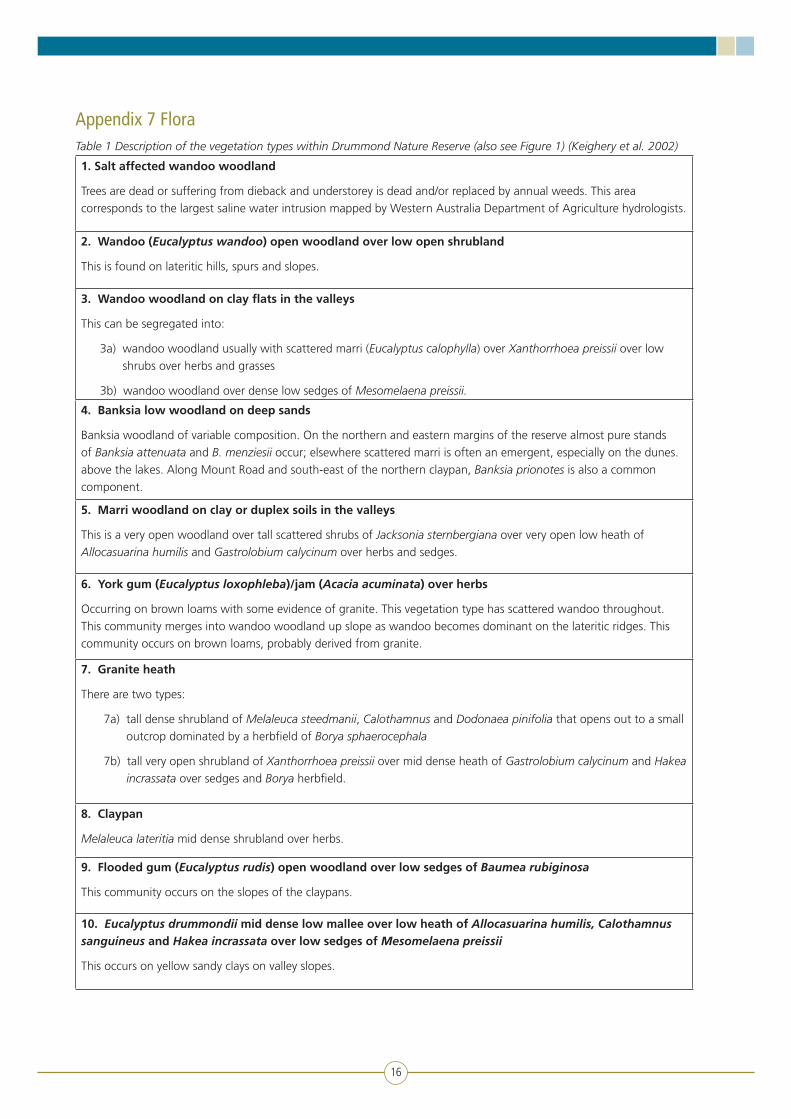
Vascular flora list of Drummond Nature Reserve (from Keighery et al. 2002, Gibson et al. 2004, Lyons et al. 2004 and FloraBase: florabase.dec.wa.gov.au specimen data accessed June 2010) (* indicates introduced plants).
Isoetaceae
Isoetes drummondii
Selaginellaceae
Selaginella gracillima
Ophioglossaceae
Ophioglossum lusitanicum
Pteridaceae
Cheilanthes austrotenuifolia
Zamiaceae
Macrozamia riedlei
Hydatellaceae
Trithuria austinensis
Trithuria australis
Trithuria bibracteata
Trithuria submersa
Lauraceae
Cassytha flava
Juncaginaceae
Triglochin calcitrapa
Triglochin linearis
Triglochin minutissima
Colchicaceae
Burchardia congesta
Wurmbea dioica
Orchidaceae
Caladenia discoidea
Caladenia flava
Caladenia hirta subsp. hirta
Caladenia longicauda
Caladenia longiclavata
Caladenia marginata
Caladenia speciosa
Caladenia splendens
Cyanicula gemmata
Cyanicula sericea
*Disa bracteata
Diuris brumalis
Diuris corymbosa
Diuris recurva
Eriochilus dilatatus
Leporella fimbriata
Microtis media
Microtis orbicularis
Prasophyllum hians
Prasophyllum macrostachyum
Prasophyllum ovale
Prasophyllum plumiforme
Pterostylis brevisepala
Pterostylis pyramidalis
Pterostylis recurva
Pterostylis sanguinea
Pyrorchis nigricans
Thelymitra antennifera
Thelymitra benthamiana
Thelymitra crinita
Thelymitra flexuosa
Thelymitra maculata
Boryaceae
Borya laciniata
Borya scirpoidea
Borya sphaerocephala
Hypoxidaceae
Hypoxis occidentalis
Iridaceae
*Gladiolus caryophyllaceus
*Hesperantha falcata
Orthrosanthus laxus
Patersonia occidentalis
Patersonia rudis
*Romulea rosea
Xanthorrhoeaceae
Xanthorrhoea preissii
Asparagaceae
Chamaescilla corymbosa
Chamaescilla spiralis
Dichopogon capillipes
Dichopogon fimbriatus

21
Dichopogon preissii
Laxmannia grandiflora
Laxmannia omnifertilis
Laxmannia ramosa
Laxmannia ramosa subsp. ramosa
Laxmannia sessiliflora
Laxmannia squarrosa
Lomandra caespitosa
Lomandra effusa
Lomandra micrantha
Lomandra sericea
Lomandra suaveolens
Sowerbaea laxiflora
Thysanotus patersonii
Thysanotus thyrsoideus
Hemerocallidaceae
Agrostocrinum scabrum subsp. scabrum
Caesia sp. Wongan
Corynotheca micrantha
Dianella revoluta
Stypandra glauca
Tricoryne elatior
Tricoryne sp. Wongan Hills
Tricoryne tenella
Philydraceae
Philydrella pygmaea
Haemodoraceae
Anigozanthos bicolor
Anigozanthos humilis
Conostylis androstemma
Conostylis aurea
Conostylis candicans
Conostylis setigera
Conostylis stylidioides
Haemodorum brevisepalum
Haemodorum discolor
Haemodorum paniculatum
Haemodorum simplex
Haemodorum spicatum
Tribonanthes longipetala
Tribonanthes violacea
Dasypogonaceae
Calectasia cyanea
Calectasia narragara
Juncaceae
*Juncus bufonius
*Juncus capitatus
Cyperaceae
Baumea juncea
Baumea rubiginosa
Caustis dioica
Chorizandra enodis
Cyathochaeta avenacea
Cyathochaeta equitans
*Cyperus tenellus
Eleocharis keigheryi
Isolepis cernua
Isolepis marginata
Isolepis stellata
Lepidosperma leptostachyum
Lepidosperma pubisquameum
Lepidosperma striatum
Lepidosperma tenue
Lepidosperma viscidum
Mesomelaena preissii
Mesomelaena pseudostygia
Mesomelaena tetragona
Schoenus clandestinus
Schoenus curvifolius
Schoenus elegans
Schoenus aff. loliaceus
Schoenus nanus
Schoenus natans
Schoenus odontocarpus
Schoenus rigens
Schoenus sculptus
Schoenus subbulbosus
Schoenus subfascicularis
Schoenus tenellus
Schoenus variicellae
Tetraria octandra

22
Anarthriaceae
Lyginia barbata
Centrolepidaceae
Aphelia brizula
Aphelia cyperoides
Aphelia drummondii
Centrolepis alepyroides
Centrolepis aristata
Centrolepis cephaloformis
Centrolepis drummondiana
Centrolepis glabra
Centrolepis mutica
Centrolepis pilosa
Centrolepis polygyna
Restionaceae
Alexgeorgea nitens
Desmocladus asper
Harperia lateriflora
Hypolaena exsulca
Lepidobolus preissianus
Lepyrodia muirii
Meeboldina coangustata
Poaceae
*Aira caryophyllea
Amphibromus nervosus
Amphipogon strictus
Amphipogon turbinatus
Aristida contorta
Austrodanthonia acerosa
Austrodanthonia ?setacea
Austrostipa compressa
Austrostipa elegantissima
Austrostipa pycnostachya
Austrostipa trichophylla
*Avena barbata
*Brachypodium distachyon
*Briza maxima
*Briza minor
*Bromus diandrus
Ehrharta longiflora
Lachnagrostis filiformis
*Lolium rigidum
Microlaena stipoides
Neurachne alopecuroidea
*Parapholis incurva
Poa drummondiana
Polypogon tenellus
*Triticum aestivum
*Vulpia myuros
Proteaceae
Adenanthos cygnorum
Adenanthos drummondii
Banksia attenuata
Banksia bipinnatifida
Banksia dallanneyi
Banksia fraseri
Banksia grandis
Banksia menziesii
Banksia prionotes
Banksia sessilis
Banksia squarrosa
Conospermum glumaceum
Conospermum stoechadis
Grevillea bipinnatifida
Grevillea scabra
Grevillea synapheae
Grevillea vestita
Hakea incrassata
Hakea lissocarpha
Hakea preissii
Hakea prostrata
Hakea ruscifolia
Hakea stenocarpa
Hakea trifurcata
Hakea undulata
Hakea varia
Isopogon divergens
Isopogon dubius
Persoonia angustiflora
Persoonia quinquenervis
Persoonia striata
Persoonia sulcata

23
Petrophile brevifolia
Petrophile striata
Stirlingia latifolia
Synaphea interioris
Synaphea petiolaris
Dilleniaceae
Hibbertia acerosa
Hibbertia commutata
Hibbertia huegelii
Hibbertia hypericoides
Hibbertia polystachya
Hibbertia racemosa
Hibbertia spicata
Hibbertia subvaginata
Crassulaceae
Crassula closiana
Crassula colorata
Crassula exserta
*Crassula natans
Haloragaceae
Glischrocaryon aureum
Gonocarpus cordiger
Gonocarpus nodulosus
Myriophyllum echinatum
Fabaceae
Acacia acuminata
Acacia applanata
Acacia chapmanii subsp. australis
Acacia drummondii subsp. affinis
Acacia ericifolia
Acacia incrassata
Acacia lasiocarpa
Acacia lasiocarpa var. sedifolia
Acacia latipes
Acacia microbotrya
Acacia pulchella
Acacia saligna
Acacia shuttleworthii
Acacia stenoptera
Aotus procumbens
Bossiaea eriocarpa
Bossiaea spinescens
Daviesia angulata
Daviesia cardiophylla
Daviesia decurrens
Daviesia hakeoides subsp. hakeoides
Daviesia preissii
Gastrolobium calycinum
Gastrolobium capitatum
Gastrolobium spinosum
Gompholobium marginatum
Gompholobium tomentosum
Hovea pungens
Hovea trisperma var. trisperma
Isotropis cuneifolia
Jacksonia furcellata
Jacksonia restioides
Jacksonia sternbergiana
Kennedia prostrata
Mirbelia trichocalyx
*Trifolium arvense
*Trifolium campestre
Polygalaceae
Comesperma calymega
Comesperma ciliatum
Comesperma integerrimum
Comesperma rhadinocarpum
Comesperma volubile
Rhamnaceae
Cryptandra nutans
Stenanthemum tridentatum
Casuarinaceae
Allocasuarina campestris
Allocasuarina huegeliana
Allocasuarina humilis
Allocasuarina microstachya
Allocasuarina thuyoides
Apodanthaceae
Pilostyles hamiltonii
Celastraceae
Stackhousia monogyna
Tripterococcus brunonis
24
Oxalidaceae
Oxalis perennans
Euphorbiaceae
Ricinocarpos glaucus
Phyllanthaceae
Phyllanthus calycinus
Poranthera microphylla
Linaceae
Linum marginale
Hypericaceae
Hypericum japonicum
Geraniaceae
Erodium crinitum
Erodium cygnorum
Lythraceae
*Lythrum hyssopifolia
Myrtaceae
Babingtonia camphorosmae
Baeckea crispiflora
Baeckea grandiflora
Calothamnus sanguineus
Calothamnus quadrifidus
Calytrix flavescens
Calytrix fraseri
Calytrix strigosa
Corymbia calophylla
Eucalyptus drummondii
Eucalyptus loxophleba x wandoo
Eucalyptus marginata
Eucalyptus rudis
Eucalyptus wandoo
Hypocalymma angustifolium
Leptospermum erubescens
Melaleuca fulgens subsp. steedmanii
Melaleuca lateritia
Melaleuca leptospermoides
Melaleuca radula
Melaleuca scabra
Melaleuca viminea
Scholtzia involucrata
Verticordia densiflora
Verticordia huegelii var. tridens
Verticordia pennigera
Verticordia roei
Verticordia serrata
Verticordia serrata var. ciliata
Sapindaceae
Dodonaea pinifolia
Malvaceae
Keraudrenia integrifolia
Thomasia grandiflora
Thymelaeaceae
Pimelea argentea
Pimelea suaveolens
Brassicaceae
Lepidium rotundum
Olacaceae
Olax benthamiana
Santalaceae
Santalum acuminatum
Loranthaceae
Amyema miquelii
Amyema preissii
Nuytsia floribunda
Polygonaceae
Muehlenbeckia adpressa
Droseraceae
Drosera bulbosa
Drosera erythrorhiza
Drosera gigantea
Drosera glanduligera
Drosera heterophylla
Drosera leucoblasta
Drosera macrophylla
Drosera menziesii
Drosera omissa
Drosera pallida
Drosera pycnoblasta
Drosera stolonifera
Drosera zonaria

25
Amaranthaceae
Ptilotus declinatus
Ptilotus manglesii
Ptilotus polystachyus
Ptilotus stirlingii
Portulacaceae
Calandrinia composita
Calandrinia corrigioloides
Calandrinia granulifera
Calandrinia liniflora
Calandrinia aff. ptychosperma
Primulaceae
*Lysimachia arvensis
Ericaceae
Astroloma macrocalyx
Astroloma pallidum
Astroloma prostratum
Astroloma serratifolium
Leucopogon glaucifolius
Leucopogon sp. Bolgart
Leucopogon tamminensis
Lysinema ciliatum
Styphelia tenuiflora
Rubiaceae
Opercularia vaginata
Gentianaceae
*Centaurium erythraea
*Cicendia filiformis
Loganiaceae
Logania flaviflora
Phyllangium paradoxum
Apocynaceae
Rhyncharrhena linearis
Boraginaceae
*Echium plantagineum
Halgania anagalloides var. Southern
Plantaginaceae
Gratiola pubescens
Lamiaceae
Hemigenia sericea
Phrymaceae
Glossostigma diandrum
Orobanchaceae
*Bartsia trixago
*Orobanche minor
*Parentucellia latifolia
*Parentucellia viscosa
Lentibulariaceae
Utricularia inaequalis
Utricularia violacea
Campanulaceae
Isotoma hypocrateriformis
Lobelia gibbosa
Lobelia heterophylla
*Monopsis debilis
Wahlenbergia preissii
Stylidiaceae
Levenhookia pusilla
Levenhookia stipitata
Stylidium affine
Stylidium brunonianum
Stylidium calcaratum
Stylidium cilium
Stylidium despectum
Stylidium dichotomum
Stylidium ecorne
Stylidium emarginatum
Stylidium eriopodum
Stylidium inundatum
Stylidium longitubum
Stylidium miniatum
Stylidium piliferum
Stylidium pycnostachyum
Stylidium repens
Stylidium sacculatum
Menyanthaceae
Liparophyllum capitatum
Goodeniaceae
Dampiera alata
Dampiera incana

26
Dampiera lavandulacea
Goodenia berardiana
Goodenia coerulea
Goodenia glareicola
Goodenia micrantha
Goodenia cf. mimuloides
Goodenia pulchella
Goodenia pulchella subsp. Wheatbelt
Lechenaultia biloba
Lechenaultia expansa
Scaevola repens
Verreauxia reinwardtii
Asteraceae
Angianthus tomentosus
*Arctotheca calendula
Blennospora drummondii
Brachyscome glandulosa
Brachyscome iberidifolia
Calotis hispidula
*Carduus pycnocephalus
Cotula cotuloides
Euchiton sphaericus
Gnephosis tenuissima
Gnephosis uniflora
Helichrysum leucopsideum
Hyalosperma cotula
Hypochaeris glabra
Lagenophora huegelii
Lawrencella rosea
Millotia myosotidifolia
Millotia tenuifolia
Myriocephalus occidentalis
Olearia rudis
Podolepis canescens
Podolepis gracilis
Podolepis lessonii
Podotheca angustifolia
Podotheca gnaphalioides
Pterochaeta paniculata
Quinetia urvillei
Rhodanthe laevis
Rhodanthe manglesii
Rhodanthe pyrethrum
Senecio pinnatifolius
Siloxerus humifusus
Siloxerus multiflorus
Trichocline spathulata
*Ursinia anthemoides
Waitzia acuminata
Waitzia nitida
Waitzia suaveolens
Pittosporaceae
Billardiera heterophylla
Billardiera venusta
Cheiranthera preissiana
Marianthus bicolor
Araliaceae
Hydrocotyle alata
Hydrocotyle lemnoides
Hydrocotyle medicaginoides
Hydrocotyle pilifera
Trachymene cyanopetala
Trachymene ornata
Trachymene pilosa
Apiaceae
Daucus glochidiatus
Homalosciadium homalocarpum
Platysace juncea
Platysace maxwellii
Platysace ramosissima
Xanthosia candida
Xanthosia huegelii

27
Appendix 8 FaunaTable 1 Records of fauna from limited surveys at Drummond Nature Reserve (from Department of Conservation and Land Management 2001 and Burbidge et al. 2004)
Birds
Acanthiza chrysorrhoa Yellow-rumped thornbill
Acanthiza inornata Western thornbill
Anthochaera carunculata Red wattlebird
Artamus cyanopterus Dusky woodswallow
Barnardius zonarius Australian ringneck
Calyptorhynchus latirostris Carnaby’s cockatoo
Climacteris rufa Rufous treecreeper
Coracina novaehollandiae Black-faced cuckoo-shrike
Corvus coronoides Australian raven
Cracticus tibicen Australian magpie
Cracticus torquatus Grey butcherbird
Dacelo novaeguineae Laughing kookaburra
Eolophus roseicapillus Galah
Gerygone fusca Western gerygone
Lichmera indistincta Brown honeyeater
Merops ornatus Rainbow bee-eater
Phaps chalcoptera Common bronzewing
Phylidonyris niger White-cheeked honeyeater
Rhipidura albiscapa Grey fantail
Smicrornis brevirostris Weebill
Zosterops lateralis Silvereye
Mammals
Antechinus flavipes Yellow-footed antechinus
Cercartetus concinnus Western pygmy-possum
Macropus irma Western brush wallaby
Macropus fuliginosus Western grey kangaroo
Tachyglossus aculeatus Echidna
Tarsipes rostratus Honey possum
Reptiles
Cryptoblepharus plagiocephalus Fence skink
Ctenotus fallens West-coast laterite ctenotus
Lerista distinguenda South-western orange-tailed slider
Morethia obscura Shrubland morethia skink

28
Pogona minor Western bearded dragon
Tiliqua subsp. rugosa Bobtail
Varanus tristis Racehorse monitor
Frogs
Heleioporus eyrei Moaning frog
Heleioporus psammophilus Sand frog
Neobatrachus albipes White-footed frog

29
Appendix 9 Conservation codes
Western AustraliaUnder the Wildlife Conservation Act 1950, specially protected species are listed under one of four schedules:
Schedule 1 – Species that are rare or likely to become extinct. Species listed under Schedule 1 are also referred to as threatened fauna or threatened flora (declared rare flora).
Schedule 2 – Species presumed to be extinct.
Schedule 3 – Migratory birds protected under an international agreement.
Schedule 4 – Other specially protected fauna.
Although it is not shown in the legislation, the Department of Environment and Conservation also classifies specially protected species into one of five IUCN categories: Extinct (EX) shown on Schedule 2 and; Extinct in the Wild (EW), Critically Endangered (CR), Endangered (EN) or Vulnerable (VU), all listed on Schedule 1. These categories are determined by the total distribution of the species and not just their distribution within Western Australia.
Priority species
If a species does not meet the criteria for listing as threatened fauna or threatened flora (e.g. due to lack of information) and is poorly known and/or conservation dependent, it may be deemed a Priority species. Priority species are defined as:
Priority one (P1): Taxa with few, poorly known populations on threatened lands.
Priority two (P2): Taxa with few, poorly known populations on conservation lands.
Priority three (P3): Taxa with several, poorly known populations, some on conservation lands.
Priority four (P4): Taxa in need of monitoring.
Priority five (P5): Taxa that are conservation dependent (i.e. their conservation status is dependent on ongoing active management).
CommonwealthThreatened fauna and flora may be listed in any one of the following categories under the Commonwealth’s Environment Protection and Biodiversity Conservation Act 1999 (EPBC Act):
EX – Extinct
EW – Extinct in the wild
CR – Critically endangered
EN – Endangered
VU – Vulnerable
CD – Conservation dependent
Migratory – Migratory species that are listed under the Bonn Convention, JAMBA, CAMBA and ROKAMBA.
Marine – Marine species listed under section 248 of the EPBC Act.
InternationalIUCN Categories and Criteria (IUCN Standards and Petitions Subcommittee 2010).
Extinct (EX)
A taxon is extinct when there is no reasonable doubt that the last individual has died. A taxon is presumed extinct when exhaustive surveys in known and/or expected habitat, at appropriate times (diurnal, seasonal, annual), throughout its historic range have failed to record an individual. Surveys should be over a timeframe appropriate to the taxon’s life cycles and life form.
Extinct in the wild (EW)
A taxon is extinct in the wild when it is known only to survive in cultivation, in captivity or as a naturalised population (or populations) well outside the past range. A taxon is presumed extinct in the wild when exhaustive surveys in known and/or expected habitat, at appropriate times (diurnal, seasonal, annual), throughout its historic range have failed to record an individual. Surveys should be over a timeframe appropriate to the taxon’s life cycle and life form.
Critically endangered (CR)
A taxon is critically endangered when the best available evidence indicates that it meets any of the criteria A to E for critically endangered, and it is therefore considered to be facing an extremely high risk of extinction in the wild.
Endangered (EN)
A taxon is endangered when the best available evidence indicates that it meets any of the criteria A to E for endangered, and it is therefore considered to be facing a very high risk of extinction in the wild.
Vulnerable (VU)
A taxon is vulnerable when the best available evidence indicates that it meets any of the criteria A to E for vulnerable, and it is therefore considered to be facing a high risk of extinction in the wild.

30
Near threatened (NT)
A taxon is near threatened when it has been evaluated against the criteria but does not qualify for critically endangered, endangered or vulnerable now, but is close to qualifying for or is likely to qualify for a threatened category in the near future.
Least concern (LC)
A taxon is least concern when it has been evaluated against the criteria and does not qualify for critically endangered, endangered, vulnerable or near threatened. Widespread and abundant taxa are included in this category.

31
Appendix 10 Invertebrates
Drummond natural diversity recovery catchment aquatic invertebrate surveyDavid Cale, Department of Conservation and Land Management, Science Division, September 2005.
Summary
Drummond Nature Reserve is a central biodiversity icon for the newly established Drummond Natural Diversity Recovery Catchment. The nature reserve includes two small claypan wetlands, for which no survey of aquatic invertebrates has previously been conducted.
Invertebrates were sampled from both wetlands in October 2004 and water chemistry parameters measured.
The wetlands within Drummond Nature Reserve support very diverse aquatic invertebrate communities including three new species of Rotifera and two new species of Ostracoda.
The core species of the invertebrate assemblage have been described from the survey of the wheatbelt (Pinder et al. 2004) and have been recorded in swamp-like fresh water wetlands from the Jarrah Forest and Esperance Plains bioregions. There are examples of similar wetland type and faunal assemblage on other nature reserves, for example Lake Pleasant View, Pabellup Swamp, Noobijup Swamp and Lake Pindicup.
The observed aquatic invertebrate fauna is likely to be intolerant to changes in salinity and water chemistry and steps to identify and manage such changes should be implemented.
Introduction
The Drummond Biodiversity Recovery Catchment was established in 2002 to include the sub catchments of Solomons Brook, Yulgan Brook and Anvil Gully. The catchment has as a central biodiversity icon the Drummond Nature Reserve; with an area of 439 hectares of principally open wandoo and marri woodland that includes two small wetlands.
The biodiversity of Drummond Nature Reserve has not been thoroughly documented, however, Keighery et al. (2000) recognised 429 species of vascular plant including two declared rare flora and seven priority species. Four of these plant species are aquatic and restricted to two shallow claypan wetlands. These wetlands are fresh and ephemeral and have not been surveyed for aquatic fauna, although three frog species have been identified (Norm McKenzie, Department of Conservation and Land Management pers. comm.) The associated wetland plant communities are uncommon, with Keighery et al. (2000) suggesting they are ‘…largely confined to the Swan
Coastal Plain and parts of the Jarrah Forest’ and are at their eastern limit in the Drummond Nature Reserve.
To further detail the biodiversity of Drummond Nature Reserve this report documents the aquatic invertebrate fauna collected from a single survey event in October 2004.
Methods
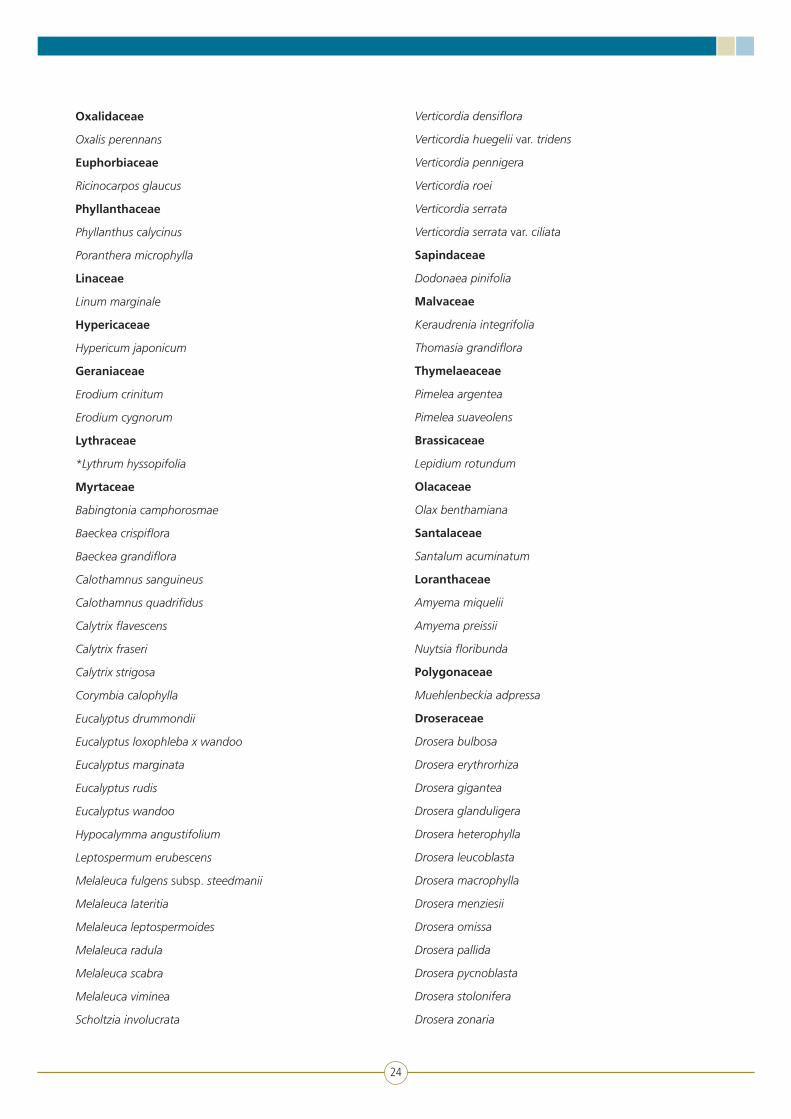
Two wetlands within the Drummond Nature Reserve were sampled for aquatic invertebrates, waterbirds and associated water chemistry. The first wetland is located at the south western corner of the reserve and was labelled Site A (Figure 1). The second wetland lies within a dunal depression in the north-east quadrant of the reserve and was labelled Site B (Figure 1). Both wetlands are shallow (<0.5 metres maximum depth) with a canopy of Melaleuca lateritia and a clay/organic substrate under a patchy layer of aquatic herbs.
The wetlands were visited for sampling on 26/8/2004, 15/10/2004 and 7/3/2005. Waterbirds were surveyed on all visits using binoculars while walking through and around each wetland. The small size of the wetlands greatly aided visibility, however, no species were recorded.
The sampling methods for aquatic invertebrates have been described in detail elsewhere (Cale et al. 2004). Briefly, a benthic sample was collected using a D-net with 250-micrometre mesh size. This sample was collected as a series of sweeps equivalent to a total of 50 metres of sample and was collected from all identifiable habitats in a transect of approximately 200 metres in length. A plankton sample was collected using a D-net with a 50- micrometre mesh size. The plankton sample was collected in a similar fashion but concentrated on the water column with minimum disturbance of bottom sediments. This ‘large sample’ protocol was designed to collect as many invertebrate species as possible and is identical to that used for the Wheatbelt Wetlands Monitoring Project (Cale et al. 2004) and Salinity Action Plan Wheatbelt Survey (Pinder et al. 2004). Benthic and plankton samples were collected from site A and B on 15 October 2004.
Field measurements of pH, electrical conductivity (Ec), temperature and dissolved oxygen were collected at sites A and B on 26 August 2004 using a WTW multi-line meter. At this time water samples were also collected, from Site A, for the laboratory analysis of total nitrogen, total phosphorus and chlorophyll concentration. On 15 October 2004 these same measurements were collected for Site B and additional water samples were collected to determine ionic composition, turbidity and colour. Both wetlands were dry when revisited in March 2005.

32
Invertebrates were sorted under a dissecting microscope and identified to the lowest possible taxon. In most cases this was species, however, for some dipteran groups, family was the lowest determination possible. Specialist taxonomists were engaged to identify some groups, principally Rotifera and Chydoridae (Dr Russel Shiel, Adelaide University), Ostracoda (Dr Stuart Halse, Department of Conservation and Land Management), Cyclopoida and Harpacticoida (Ms Jane McRae, Department of Conservation and Land Management).
Results and discussion
With respect to habitat, the two wetlands, Site A and B, differed little. Site B was deeper, ranging from 5 to 25 centimetres deep on 15 October 2004 compared to 2–15 centimetres over most of Site A. The greater depth at Site B translated into more areas of denser aquatic vegetation than occurred at Site A. Both sites were fresh with maximum salinity (531µS/cm) measured at Site B on 15 October 2004 (Table 1). Site B was sodium dominated but showed a high relative concentration of potassium and low calcium to yield a cation dominance pattern of
Na>Mg>K>Ca. Anions were dominated by chloride and bicarbonate was greater than sulphate.
Moderate total-nitrogen concentrations (Table 1) at both sites suggest that seasonal inflow may be slightly enriched, however, total-phosphorus concentrations were low and likely to be limiting total wetland production. Seasonal drying of the wetland will result in high annual variations in total-nitrogen concentration as varying amounts of accumulated material are de-nitrified or volatilised, this will be less true of total-phosphorus. Observed concentrations of nutrients are unlikely to adversely affect invertebrate communities but, given the moderately high concentration of total nitrogen, increased concentrations of phosphorus should be guarded against as they may give rise to greater algal growth and the potential for habitat change.
A total of 111 taxa thought to be distinct species were collected from the two wetlands, with 74 taxa at Site A and 90 taxa at Site B (Table 2). This is a high level of species richness. On the basis of the species richness at each site, both wetlands would rank within the top decile of the 207 wetland and river sites sampled in a
Figure 1 Drummond Nature Reserve showing the location of the two sampled wetlands

33
recent wheatbelt survey (Pinder et al. 2004). The study by Pinder et al. (2004) used the same sampling protocol and included a full range of wetland types from saline to fresh and disturbed to undisturbed.
Three taxonomic groups comprised the bulk of the invertebrate species collected. Insects were the most species rich and comprised 38 per cent (42 spp.) of the fauna. All of these species include winged stages and disperse readily, consequently they tend to be ubiquitous and commonly collected. Crustacea comprised 25 per cent (28 spp.) of the fauna and Rotifera 26 per cent (29 spp.) and it was amongst these groups, which are more restricted in dispersal capability, that less common species were encountered.
A number of species were identified as previously unpublished. Amongst the Rotifera a single species of each of the genera Lepadella, Lecane and Cephalodella are likely to be new species (Dr Russel Shiel, Adelaide University pers. comm.). Similarly, two genera of Ostracoda included undescribed species i.e. Lacrimicypris n.sp. and Newnhamia sp. DR4 which are likely to be the first records of these new species (Dr Stuart Halse, Department of Conservation and Land Management pers. comm). The discovery of new species of microfauna in Western Australia at this time is in large part because recent aquatic biological surveys conducted by the Department of Conservation and Land Management are the first detailed surveys in the region e.g. Carnarvon Basin (Halse et al. 2002), Wheatbelt (Pinder et al. 2004) and Pilbara (Dr Stuart Halse pers. comm.).
As well as new species some other elements of the fauna are of interest. While species of the genus Gyraulus, a small planispiral aquatic snail, are widespread in jarrah forest streams they were collected only once in the wheatbelt wetlands survey (Pinder et al. 2004). Their presence in the highly ephemeral wetlands at Drummond Nature Reserve suggest an interesting biology to cope with seasonal or long-term drying. The mosquito recorded here as Aedes (Och.) Nr stricklandi warrants further investigation as it had aberrant characters related to the lateral comb and may be undescribed.
A number of species were collected on only single occasions in the wheatbelt survey of Pinder et al. (2004) and again in the Drummond wetlands. These were the rotifer Lecane hornemanni, the gastropod Gyraulus sp., the mite Arrenurus (Micruracarus) sp. 1, the ostracod Plesiocypridopsis sp. and the beetle Hydaticus sp.. The low occurrence of these species in samples from the wheatbelt survey may reflect the absence of suitable habitat in the wheatbelt (e.g. the species may be more common in wetlands of the higher rainfall zone not included in the wheatbelt survey). However, some of these taxa may have
restricted distributions and require particular wetland types. Further survey work will elucidate this in time.
In order to place the Drummond wetlands in a broader regional context, they were included in a multivariate cluster analysis with 207 sites previously surveyed by Pinder et al. (2004).This analysis groups the wetlands according to the similarity of species assemblages present and indicated that both Drummond wetlands classified into the group described as Wetland Group 9 (WG9) by Pinder et al. (2004). This group called ‘Southern Vegetated Swamps’ occurs in the Jarrah Forest and Esperance Sandplain bioregions. Many of the surveyed wetlands of this group are on nature reserves for example Lake Pleasant View, Pabellup Swamp, Noobijup Swamp and Lake Pindicup. The main invertebrate assemblage associated with this wetland group is described as ‘…widely collected in the wetter south-west’ and ‘…a mesic adapted fauna for which the inland and Northern Wheatbelt, characterised by more seasonally variable water chemistry and hydrology, probably represents sub-optimal habitat’ (Pinder et al. 2004).
The aquatic fauna of Drummond Nature Reserve, with its high species richness and generally mesic-adapted nature will be highly susceptible to species loss with increased salinity. Pinder et al. (2004) noted altered community composition even at quite low salinity levels. Management steps should be taken to identify the risk of salinisation of the wetlands and take preventative steps.

34
Site code Site A Site B Site B
Date 26/08/2004 26/08/2004 15/10/2004
Sub site A B B
Field conductivity (µS/cm) 189 227 531
Field pH 8.51 8.08 8.16
TN (µg/L) 2300 ns 1800
TP (µg/L) 10 ns 10
Chlorophyll-a (µg/L) 2 ns 0.5
Chlorophyll-b (µg/L) 0.5 ns 1
Chlorophyll-c (µg/L) 0.5 ns 0.5
Phaeophytin-a (µg/L) 2 ns 11
Temperature (oc) 17.4 17.1 24.3
Oxygen general (%) 128.1 124.1 124.4
Turbidity (TCU) ns ns 0.6
Colour (NTU) ns ns 140
Total dissolved solids (TDSµg/L) ns ns 0.46
Alkalinity (mg/L) ns ns 29
Hardness(mg/L) ns ns 31
Silica (mg/L) ns ns 2.3
Sodium (mg/L) ns ns 121
Calcium (mg/L) ns ns 5.2
Magnesium (mg/L) ns ns 4.5
Potassium (mg/L) ns ns 10.9
Manganese (mg/L) ns ns 0.003
Chloride (mg/L) ns ns 210
Bicarbonate (mg/L) ns ns 35
Carbonate (mg/L) ns ns 1
Nitrate (mg/L) 0.02 0.02 0.01
Sulphate (mg/L) ns ns 7.9
Iron (mg/L) ns ns 0.038
Table 1 Water chemistry parameters at the two wetlands within Drummond Nature Reserve
*ns denotes not sampled.

35
Table 2 Taxa collected in the two wetlands at Drummond Nature Reserve. Lowest IDNC is the code value used to identify these species in the Wetlands Database maintained by the former Department of Conservation and Land Management, Science Division at Woodvale.
Taxa National code Drummond site A Drummond site B
Turbellaria IF999999 1 1
Nemertini IH999999 1
Nematoda II999999 1 1
Tardigrada IR999999 1
ROTIFERA
Bdelloidea smll contracted JB9999A0 1
Bdelloidea med-lrg contracted JB9999A1 1
Testudinella patina JF050201 1
Testudinella insinuata JF050202 1 1
Testudinella tasmaniensis JF050217 1 1
Asplanchnopus multiceps JP010201 1 1
Keratella procurva JP020308 1
Colurella uncinata bicuspidata JP030107 1
Lepadella ovalis JP030201 1
Lepadella biloba JP030211 1
Lepadella patella JP030224 1
Lepadella sp. JP030299 1
Dicranophorus epicharis JP040405 1 1
Euchlanis dilatata JP060101 1 1
Lecane hamata JP090129 1
Lecane hornemanni JP090132 1
Lecane ludwigii JP090136 1
Lecane luna JP090137 1
Lecane lunaris JP090138 1
Lecane quadridentata JP090154 1 1
Lecane rhytida JP090155 1
Lecane signifera JP090159 1 1
Lecane latissima JP090174 1 1
Lecane sp. s.str. JP090199 1
Cephalodella gibba JP130201 1 1
Cephalodella sp. JP130299 1
Monommata maculata JP130409 1 1
Notommata sp. JP130599 1
Trichocerca obtusidens XX000003 1 1
GASTROPODA (aquatic snails)
Glyptophysa sp. KG070299 1 1
Gyraulus sp. KG070799 1
ANNELIDA (leeches and worms)
Glossiphoniidae LH019999 1
Oligochaeta LO999999 1

36
Taxa National code Drummond site A Drummond site B
ACARINA (watermites)
Arrenurus (Micruracarus) sp.1 (SAP) MM2301A5 1 1
Oribatida MM9999A1 1 1
Mesostigmata MM9999A2 1 1
Trombidioidea MM9999A6 1
CONCHOSTRACA (clam shrimps)
Lynceus sp. OF040199 1 1
CLADOCERA (water fleas)
Latonopsis brehmi OG010201 1 1
Alona sp. OG030299 1 1
Alonella sp. OG030399 1
Dunhevedia crassa OG031201 1 1
Leberis sp. OG031799 1 1
Planicirclus alticarinatus OG032301 1 1
Rak sp. OG032799 1 1
Ceriodaphnia sp. OG040199 1
Simocephalus elizabethae OG040505 1 1
Simocephalus sp. OG040599 1
Macrothrix sp. OG060299 1
Neothrix sp. OG090399 1
OSTRACODA (seed shrimp)
Limnocythere dorsosicula OH010201 1
Candonopsis tenuis OH070101 1
Alboa worooa OH080101 1 1
Bennelongia australis OH080301 1 1
Candonocypris novaezelandiae OH080402 1 1
Cypretta baylyi OH080501 1
Cypretta aff. globosa OH0805A1 1 1
Ilyodromus amplicolis OH081901 1
Plesiocypridopsis sp. OH083099 1 1
Lacrimicypris n.sp. OH0899A0 1 1
Newnhamia sp. DR4 (SAP) OH1101A2 1
COPEPODA
Calamoecia attenuata OJ110203 1 1
Microcyclops varicans OJ310101 1 1
Mesocyclops brooksi OJ310703 1 1
Canthocamptus australicus OJ610101 1 1
Canthocamptidae sp. B (SAP) OJ6199A7 1
COLEOPTERA (beetles)1Haliplus sp. QC060199 1
Allodessus bistrigatus QC091101 1 11Paroster sp. QC091499 1 11Sternopriscus sp. QC091899 1 11Megaporus sp. QC092199 1 1
Platynectes aenescens QC092207 1

37
Taxa National code Drummond site A Drummond site B
COLEOPTERA (beetles) (cont’d)1Platynectes sp. QC092299 11Hydaticus sp. QC093099 1
Berosus australiae QC110401 1
Berosus approximans QC110404 1 1
Paranacaena littoralis QC110904 1 1
Enochrus eyrensis QC111102 1 1
Limnoxenus zelandicus QC111401 1
Paracymus pygmaeus QC111601 1
Paracymus spenceri QC111603 11Hydrophilus sp. QC111899 1
Scirtidae sp. QC209999 1 1
DIPTERA (flies)
Tipulidae group E (SAP) QD0199A4 1
Promochlonyx australiensis QD050201 1
Anopheles annulipes QD070101 1 1
Aedes (Och.) sp. nr stricklandi QD0705A0 1
Clinohelea sp. QD090699 1
Culicoides sp. QD090899 1
Dasyheleinae QD0999A2 1
Tabanidae QD239999 1 1
Stratiomyidae QD249999 1
Dolichopodidae QD369999 1
Muscidae sp. H (SAP) QD8999A7 1
Muscidae sp. QD999999 1
Procladius villosimanus QDAE0804 1
Paramerina levidensis QDAE1201 1
Tanypodinae sp. A (SAP) QDAE99A0 1
Corynoneura sp. (V49) (SAP) QDAF0699 1 1
Compterosmittia? sp. A (SAP) QDAF19A0 1
Limnophyes sp. A (SAP) QDAF28A0 1
Polypedilum nubifer QDAI0804 1
Cladopelma curtivalva QDAI2201 1
HEMIPTERA (water bugs)
Saldula brevicornis QH600201 1
Micronecta robusta QH650502 1
Anisops thienemanni QH670401 1
Anisops sp. QH670499 1
ODONATA (dragonflies and damselflies)
Austrolestes analis QO050101 1 1
Hemianax papuensis QO121201 1 1
Hemicordulia tau QO300102 1
TRICHOPTERA (caddisflies)
Lectrides sp. AV1 (PSW) QT2502A1 1 11 Larvae only; no further determination possible

38
Aquatic invertebrate diversity in Drummond Natural Diversity Recovery Catchment wetlands, 2004 to 2011Adrian Pinder, David Cale and Anna Leung, Department of Environment and Conservation, Science Division, March 2011.
Background
The two claypans in Drummond Nature Reserve were first sampled for aquatic invertebrates by Cale (2005) to assess aquatic fauna biodiversity in the newly established Drummond Natural Diversity Recovery Catchment (DNDRC). The same wetlands were sampled for the Avon Baselining Project (Jones et al. 2009) and the wetlands have now been incorporated into the State Salinity Strategy wetland monitoring project. The first sampling event for the latter was in August 2010, although only one of the two wetlands had water.
The wetland located at the south-west corner of the reserve (off Old Plains Road) is herein referred to as the ‘south-west’ wetland and the wetland accessed off Bulligan Road is referred to as the ‘north-east’ wetland. In the State Salinity Strategy monitoring these will be sites SPM030A and SPM030B respectively.
On each sampling occasion a sample of the zooplankton was taken with a net with 50µm mesh and a sample of the benthos and zooplankton was taken using a net with
mesh 250µm. An exception was an ad-hoc collection
of zooplankton in August 2004 taken using a 100µm
mesh net. In-situ measurements of pH, conductivity
and temperature were taken and water samples were
collected for measurement of total dissolved solids, ionic
composition, turbidity, hardness, alkalinity and total
filterable nutrients.
Water chemistry
Table 1 lists all of the water chemistry data for the three
sampling rounds, except that the 2010 water samples
have not yet been analysed. Both wetlands have been
fresh (TDS <500mg/L) and clear (turbidity ≤2 NTU) when
sampled, with moderate colour present at times (up to
140 TCU). Phosphorus concentrations are as low as can
be detected (10µg/L total filterable phosphorus) but
nitrogen concentrations can be moderately high (1,000 to
2,300µg/L total filterable nitrogen). The TFN concentrations
are at or above the Australian Water Quality Guidelines
for total (unfiltered) nitrogen (<1,500µg/L) for south-
western Australian wetlands (Australian and New Zealand
Environment and Conservation Council et al. 2000).
The pH is variable, with lower values recorded in 2007
(5.39 and 6.82) than in 2004 (8.08 to 8.51). The water
is normally well saturated with oxygen. Chlorophyll
concentrations are generally low and not of concern at this
stage, although they were somewhat higher (13mg/L) in
the south-west wetland in 2004.
39
South-west wetland North-east wetland
Project Cale (2005) Drummond Survey
Cale (2005) Drummond Survey Project
Jones et al. (2009) Avon Baselining Monitoring
State Salin-ity Strat-egy
Cale (2005) Drummond Survey
Cale (2005) Drummond Survey
Jones et al. (2009) Avon Baselining Project
Sample Code ADS002A ADS002 ABP032 SPM030 ADS002B ADS002B ABP030
Date Aug 2004 Oct 2004 Sep 2007 Aug 2010 Aug 2004 Oct 2004 Sep 2007
Depth (cm) 25 15 20 6 30 30 20
Field conductivity (µS/cm)
189 177 205 227 531 350
Field pH 8.51 5.39 8.67 8.08 8.16 6.82
TN (µg/L) 2300 1000 1800 1700
TP (µg/L) 10 10 10 10
Total chlorophyll 5 2 13 2
Temperature (˚C) 17.4 24.3 13.3 15.9 17.1 24.3 18.5
Oxygen (%) 128.1 124.1 124.4
Turbidity (NCU) 2 0.6 0.9
Colour (TCU) 4 140 84
Total dissolved solids (TDS g/L)
99 460 160
Alkalinity (mg/L) 5 29 25
Hardness (mg/L) 8 31 14
Silica (mg/L) 3.5 2.3 2.4
Sodium (mg/L) 28.6 121 53.7
Calcium (mg/L) 1.3 5.2 2.9
Magnesium (mg/L) 1.2 4.5 1.5
Potassium (mg/L) 4.9 10.9 5.9
Manganese (mg/L) 0.022 0.003 0.002
Chloride (mg/L) 44 210 67
Bicarbonate (mg/L) 6 35 31
Carbonate (mg/L) 0.5 1 0.5
Nitrate (mg/L) 0.02 0.02 0.02 0.01 0.02
Sulphate (mg/L) 2.8 7.9 4.8
Iron (mg/L) 0.049 0.038 0.1
Table 1 Surface water physico-chemical data for the Drummond Nature Reserve claypans

40
Aquatic invertebrates
Richness
The aquatic invertebrate data is provided in Attachment 1. A total of 151 species has been recorded, with an average of 59 ± 12 per sample. About half of these species have only been recorded in one of the six samples. Richness per sample at Drummond is comparable to that of other clay-based wetlands (Figure 1) but seems to be particularly variable, with the 2007 and 2010 richness (39 to 45) being only about half that recorded in 2004 (78 and 93). The lower richness in 2007, compared to 2004, is not obviously related to water depth (since depth was about as high in Sep 2007 (20 centimetres) as it was in Oct 2004 (15 to 30 centimetres) but the period since flooding may have been different. pH was lower in 2007 but not sufficiently so to have influenced the fauna. Invertebrates ‘missing’ in 2007 but present in one or both samples in 2004 included about equal numbers of aerially dispersing species and those with drought-resistant propagules, indicating that the reduced diversity could have been due to a combination of reduced hatching and colonisation success. Richness in the single 2010 sample was about the same as in 2007, despite water depths being much lower (six centimetres).
Composition
The fauna includes some rare and/or interesting elements, as previously discussed by Cale (2005). However, some of the species flagged as new by Cale (2005) have since turned out not to be. In particular, the Cephalodella rotifer mentioned remains of uncertain identity while the Lepadella rotifer from the north-west wetland has been tentatively identified as L. acuminata by Russell Shiel (University of Adelaide). Russell Shiel has suggested that the unidentified Lecane rotifer from the south-west wetland may be a new species. There is a great deal of taxonomic work required on Australian rotifers and significant cryptic diversity is being revealed. Moreover, south-western Australia seems to be a ‘hotspot’ for rotifer (and other microinvertebrate) diversity (Segers et al. 2003), so regular collection of new species is expected. The ostracods Lacrimicypris n.sp. and Newnhamia sp. DR4 are likely to be new but require further work by specialists. Cale (2005) also suggested that the mosquito Aedes (Och.) nr stricklandi may be undescribed. This has since been collected from Drummond wetlands in 2007 and 2010 and from Dobaderry Swamp, about 30 kilometres west of the town of Beverley (Jones et al. 2009), but it has not been collected during any other DEC project. It is listed in Table
Figure 1 Invertebrate species richness in Drummond NDRC wetlands (blue columns) and a range of other clay-based wetlands (red columns) in the south-west of Western Australia

41
2 as Aedes sp. 5 (Dobaderry).
Cale (2005) listed several additional species that have
otherwise rarely been collected, at least in the inland
south-west: Gyraulus snails, rotifer Lecane hornemanni, ostracod Plesiocypridopsis sp., water mite Arrenurus (Micruracarus) sp. 1 and the beetle Hydaticus sp. (as
larvae). Additionally, the calanoid copepod Boeckella geniculata, a south-west WA endemic, recorded in the
south-west Drummond wetland in 2004, 2007 and 2010,
has also rarely been collected elsewhere (from a few fresh,
mostly temporary, wetlands in the far south-west and
south-coast). A species of cladoceran collected in 2010
has been tentatively identified as Alona kendallensis. This
is a rarely collected species, with the only other inland
south-west record being Yorkrakine Rock in 2007 (Jones et
al. 2009), although it appears to be more common on the
Swan Coastal Plain and is widely distributed in southern
and eastern Australia. Most records of the chironomid
Pentaneurini sp. A have been from the Drummond
wetlands (2004, 2007 and 2010) and Dobaderry Swamp
(2007), but there are a few records further south
(Ngopitchup Swamp, Cairn Rock and Noobijup Swamp –
which are also temporary freshwater wetlands).
In August 2004, David Cale collected a plankton sample
from the south-west wetland just in case the wetland
dried before the scheduled October invertebrate sampling.
This sample has only recently been processed. This was an
opportunistic collection and the only net on hand was a
110µm mesh net, so some rotifers would not have been
collected. A benthic sample was not collected so overall
richness of this collection is not considered. Twenty-
five species were collected, of which eleven were not
collected from the same wetland in the following October,
suggesting that there was significant turnover in species
between sampling events. Three of these species were not
present in any of the five subsequent samples from either
of the Drummond wetlands: mesoveliid hemipterans,
lepidopteran larvae (possibly terrestrial) and the non-biting
midge Pentaneurini sp. F. Three of the seven indicator
species (see below) were collected.
Significant compositional change over a period of two
months is expected in seasonally inundated wetlands and
stage of the hydrological cycle can be a source of variation
in community composition. This is especially true during
the period following flooding and during the drying
period if water quality declines. Sampling at a consistent
stage of the hydrological cycle is difficult to achieve
where there is no real time monitoring of hydrology and
budget constraints mean that geographically disparate
wetlands need to be sampled during a single field trip.
Nonetheless, the community is probably sufficiently well
developed by about six to eight weeks after flooding for
timing of sampling not to significantly affect monitoring
against proposed biodiversity targets. That is, sampling
undertaken after this lag should adequately represent the community and allow the full range of indicator species to be collected.
Sampling every year, rather than biennially, and considering monitoring results over several years will also help to smooth out interannual differences caused by inconsistent timing of sampling (and other factors). The Installation of a depth logger (planned for 2011) will allow better interpretation of invertebrate data.
Draft biodiversity targets set for the Drummond wetlands by the recovery catchment suggest the following triggers for management action:
1 community composition should not differ significantly from baseline data over a five-year timeframe
2 no less than four indicator species should be present in any one wetland and no less than six indicator species should be present across both wetlands on any one sampling occasion.
Many wetlands in south-western Australia vary substantially in physical and chemical characteristics from year to year and this leads to variability in faunal composition. This biological variability makes establishment of baseline community composition difficult when there is little data. The first of the above targets is tentatively based on the 2004 and 2007 data but this may need to be revisited as we undertake more sampling. Further years with similar wetland conditions may need to be included in the baseline to account for the range of natural variation in composition. In 2010 there was only a minor filling of the south-west wetland and the north-east wetland was dry when visited. Since climate change is considered a significant threat to these wetlands, the 2010 data was used as a test of the current baseline.
Figure 2 is an ordination of invertebrate communities in all five of the 2004 to 2010 Drummond samples, together with data from a selection of other clay-based wetlands for context. This is a non-metric multidimensional scaling produced using Primer v6 (Primer-E Ltd. 2008). In this analysis the two 2004 Drummond samples grouped separately from the two 2007 samples and the 2010 sample was placed outside of the range of the earlier samples (2004 and 2007). The Drummond samples are aligned along a time (year) gradient in this ordination, but with only three sampling occasions it may be too early to suggest that this is a temporal trend in composition. The community composition target above is for no change from baseline composition over a five-year period, so additional sampling in coming years is required to assess this target. Moreover, the gradient is also a seasonal one, with the 2004 collections made in October, the 2007

42
samples collected in September and the 2010 samples collected in August (because of the risk of complete drying by delaying sampling).
The second target refers to a list of seven species closely associated with seasonal clay-based wetlands in inland south-western Australia. These species are:
• clam shrimp (Lynceus sp.)
• ostracod (Bennelongia australis)
• beetle (Paroster couragei)
• beetle (Berosus approximans)
• copepod (Calamoecia attenuata)
• phantom midge (Promochlonyx australiensis)
• cladoceran (Latonopsis brehmi).
Figure 2 Two-dimensional ordination of invertabrate communities in the Drummond wetlands (in blue) and other clay-based wetlands of the south-west
Table 2 shows the number of claypan specialists recorded in each of the five 2004 to 2010 samples. The target is for at least six of the seven species to be present across both wetlands and for at least four to be present in any one
wetland. In 2010 only three species were recorded in the south-west wetland and the north-east wetland was dry so the combined wetland measure was not possible.
Table 2 Richness of the suite of species associated with seasonal clay-based wetlands of the inland south-west of Western Australia
Number of species typically occurring in clay-based seasonal wetlands in south-west WA
Date SamplePer wetland (1 sample)
Per year (2 samples)
Oct 2004 South-west 67
Oct 2004 North-east 7
Sep 2007 South-west 67
Sep 2007 North-east 5
Oct 2010 South-west 3 -

43
Summary
Aquatic invertebrate richness was much higher in 2004 than in either 2007 or 2010. Without knowledge of the timing and duration of the flood event prior to sampling it is difficult to comment on the reason for the low 2007 richness. In 2010 it is probably due to the very small amount of water present prior to, and during, sampling. To allow better interpretation of aquatic invertebrate data in such a seasonal wetland it is recommended that a depth logger be installed. There is a suggestion in the data of a temporal trend in community composition, though it is difficult to say whether this represents a seasonal effect
or a trend over the years of data collected. Further years of data are required and it is likely that a good filling event in the next couple of years will see the wetland community return to the 2004 to 2007 composition, providing there are no major changes in water quality. The number of seasonal claypan specialists was much lower in 2010 than in previous years so that in 2010 the target of at least four species per wetland and six species across both wetlands was not met. We recommend sampling both wetlands each year to collect sufficient data to assess the invertebrate communities against the proposed biodiversity targets.

44
Att
achm
ent
1 A
ll aq
uati
c in
vert
ebra
te d
ata
for
the
Dru
mm
ond
wet
land
s fo
r 20
04 t
o 20
10
C
ale
et a
l. (2
005)
Jone
s et
al.
(200
9)St
ate
Sa
linity
St
rate
gy
Sam
ple
co
de
AD
S002
AD
S002
AD
S002
APB
030
APB
032
SPM
030
Dat
e26
/08/
2004
15/1
0/20
0415
/10/
2004
11/0
9/20
0711
/09/
2007
23/0
8/20
10
Wet
lan
dSW
***
SWN
EN
ESW
SW
Hig
her
tax
on
Fam
ilySp
ecie
s
Prot
ozoa
ns
Arc
ellid
aeA
rcel
la d
isco
ides
11
A
rcel
la s
p. b
(SA
P)
1
Flat
wor
ms
-Tu
rbel
laria
11
Ner
mer
tini
-N
emer
tini
1
Nem
atod
es-
Nem
atod
a
1
1
1
Tard
igra
des
-Ta
rdig
rada
1
-Bd
ello
idea
sp.
11
-Bd
ello
idea
sp.
2:2
1
1
-Bd
ello
idea
sp.
5:5
1
Test
udin
ellid
ae
Test
udin
ella
pat
ina
1
Test
udin
ella
insi
nuat
a
1
1
Test
udin
ella
tas
man
iens
is
1
1
Asp
lanc
hnid
aeA
spla
nchn
opus
mul
ticep
s
1
1
1
Brac
hion
idae
Ker
atel
la p
rocu
rva
1
11
1
Lepa
delli
dae
Col
urel
la u
ncin
ata
bicu
spid
ata
1
Lepa
della
ova
lis
1
Lepa
della
bilo
ba
1
Lepa
della
pat
ella
1
Lepa
della
trip
tera
1
Lepa
della
cf.
acu
min
ata
1
Dic
rano
phor
idae
Dic
rano
phor
us e
pich
aris
11
Euch
lani
dae
Euch
lani
s di
lata
ta
1
1
1
Euch
lani
s cf
. lyr
a
1
Leca
nida
e Le
cane
ham
ata
1
Leca
ne h
orne
man
ni
1
1
Leca
ne a
rcul
a
1
Leca
ne lu
dwig
ii
1

45
C
ale
et a
l. (2
005)
Jone
s et
al.
(200
9)St
ate
Sa
linity
St
rate
gy
Sam
ple
co
de
AD
S002
AD
S002
AD
S002
APB
030
APB
032
SPM
030
Dat
e26
/08/
2004
15/1
0/20
0415
/10/
2004
11/0
9/20
0711
/09/
2007
23/0
8/20
10
Wet
lan
dSW
***
SWN
EN
ESW
SW
Hig
her
tax
on
Fam
ilySp
ecie
s
Tar
digr
ades
(con
t’d)
Le
cane
luna
1
11
Leca
ne lu
naris
1
1
Leca
ne o
hioe
nsis
1
Leca
ne q
uadr
iden
tata
1
11
11
1
Leca
ne r
hytid
a
1
Leca
ne s
igni
fera
11
Leca
ne la
tissi
ma
11
Leca
ne (M
onos
tyla
) sp.
1
Leca
ne n
. sp.
?
1
Not
omm
atid
aeC
epha
lode
lla g
ibba
11
Cep
halo
della
sp.
1
Mon
omm
ata
mac
ulat
a
1
1
Mon
omm
ata
n. s
p.
(nr
mac
ulat
a), p
ossi
bly
= a
bove
1
Not
omm
ata
sp.
1
Tric
hoce
rcid
ae
Tric
hoce
rca
elon
gata
1
Tric
hoce
rca
obtu
side
ns
1
1
Snai
ls (G
astr
opod
a)
Plan
orbi
dae
Gly
ptop
hysa
sp
1
11
11
1
Gyr
aulu
s sp
.
1
11
Leec
hes
(Hiru
dine
a)G
loss
ipho
niid
aeG
loss
ipho
niid
ae
1
Aqu
atic
ear
thw
orm
s (O
ligoc
haet
a)
Nai
dida
e N
aidi
dae
(ex
Tubi
ficid
ae),
im
mat
ure
A. n
harn
a?
1
Der
o ni
vea
1
Der
o fu
rcat
a
1
Pris
tina
leid
yi
1
Ain
udril
us n
harn
a
1
1
11

46
C
ale
et a
l. (2
005)
Jone
s et
al.
(200
9)St
ate
Sa
linity
St
rate
gy
Sam
ple
co
de
AD
S002
AD
S002
AD
S002
APB
030
APB
032
SPM
030
Dat
e26
/08/
2004
15/1
0/20
0415
/10/
2004
11/0
9/20
0711
/09/
2007
23/0
8/20
10
Wet
lan
dSW
***
SWN
EN
ESW
SW
Hig
her
tax
on
Fam
ilySp
ecie
s
Wat
er m
ites
(Aca
rina)
Li
mne
siid
ae
Lim
nesi
a de
ntife
ra
1
Lim
nesi
a sp
.
1
Pion
idae
Ace
rcel
la f
alci
pes
1
1
Arr
enur
idae
Arr
enur
us (M
icru
raca
rus)
sp.
1
(SA
P)
1
1
1
-O
ribat
ida
sp.
11
-M
esos
tigm
ata
11
-Tr
ombi
dioi
dea
1
11
1
Cla
m s
hrim
ps
(Con
chos
trac
a)Ly
ncae
idae
Lync
eus
sp.
1
11
11
Wat
er fl
eas
(C
lado
cera
)
Sidi
dae
Dia
phan
osom
a un
guic
ulat
um/
cf. u
ngui
cula
tum
1
1
Lato
nops
is b
rehm
i
1
1
1
Chy
dorid
ae
Alo
na r
ecta
ngul
a no
vaez
eala
ndia
e
1
1
Alo
na s
etig
era
11
Alo
na s
p.
1
Alo
na k
enda
llens
is?
1
Alo
nella
cla
thra
tula
1
Alo
nella
sp.
1
Cel
sino
tum
sp.
?
1
Dun
heve
dia
cras
sa
1
1
Ephe
mer
opor
us b
arro
isi s
.l.
1
Lebe
ris s
p.
11
1
1
Plan
icirc
lus
altic
arin
atus
1
11
1
1
Rak
sp.
11
11
Arm
atal
ona
mac
roco
pa/c
f.
mac
roco
pa
1

47
C
ale
et a
l. (2
005)
Jone
s et
al.
(200
9)St
ate
Sa
linity
St
rate
gy
Sam
ple
co
de
AD
S002
AD
S002
AD
S002
APB
030
APB
032
SPM
030
Dat
e26
/08/
2004
15/1
0/20
0415
/10/
2004
11/0
9/20
0711
/09/
2007
23/0
8/20
10
Wet
lan
dSW
***
SWN
EN
ESW
SW
Hig
her
tax
on
Fam
ilySp
ecie
s
Wat
er fl
eas
(C
lado
cera
) (co
nt’d
) D
aphn
iidae
C
erio
daph
nia
sp.
1
11
1
Dap
hnia
car
inat
a
1
Sim
ocep
halu
s el
izab
etha
e
1
1
11
Sim
ocep
halu
s gi
bbos
us
1
Sim
ocep
halu
s he
ilong
jiang
ensi
s
1
Mac
rotr
ichi
dae
Mac
roth
rix b
revi
seta
1
Mac
roth
rix fl
abel
liger
a
1
Mac
roth
rix n
. sp.
(Dru
mm
ond)
1
Neo
tric
hida
e N
eoth
rix a
rmat
a
1
Neo
thrix
sp.
1
1
Seed
shr
imps
(O
stra
coda
)
Lim
nocy
ther
idae
Lim
nocy
ther
e do
rsos
icul
a
1
Lim
nocy
ther
e sp
. (pr
obab
ly
dors
osic
ula)
1
Can
doni
dae
Can
dono
psis
ten
uis
1
1
1
Cyp
ridid
aeA
lboa
wor
ooa
11
11
Benn
elon
gia
aust
ralis
1
11
11
Benn
elon
gia
sp.
1
Can
dono
cypr
is n
ovae
zela
ndia
e
1
1
1
Cyp
rett
a ba
ylyi
1
Cyp
rett
a sp
.
1
Cyp
rett
a af
f. g
lobo
sa
1
11
Cyp
rett
a sp
. 272
1
Ilyod
rom
us a
mpl
icol
is
11
Ilyod
rom
us s
p. B
OS0
89
1
Ples
iocy
prid
opsi
s sp
.
1
1
Lacr
imic
ypris
n.s
p.
1
1
Not
odro
mad
idae
New
nham
ia f
enes
tra
(pos
sibl
y =
DR4
?)
1
1
New
nham
ia s
p. D
R4 (S
AP)
1
1

48
C
ale
et a
l. (2
005)
Jone
s et
al.
(200
9)St
ate
Sa
linity
St
rate
gy
Sam
ple
co
de
AD
S002
AD
S002
AD
S002
APB
030
APB
032
SPM
030
Dat
e26
/08/
2004
15/1
0/20
0415
/10/
2004
11/0
9/20
0711
/09/
2007
23/0
8/20
10
Wet
lan
dSW
***
SWN
EN
ESW
SW
Hig
her
tax
on
Fam
ilySp
ecie
s
Cop
epod
s
(Cop
epod
a)
Cen
trop
agid
aeBo
ecke
lla g
enic
ulat
a
1
11
C
alam
oeci
a at
tenu
ata
11
1
C
alam
oeci
a sp
.
1
Cyc
lopi
dae
Mic
rocy
clop
s va
rican
s
1
11
11
M
etac
yclo
ps s
p. 4
34 (a
rnau
di
sens
u Sa
rs)
1
M
esoc
yclo
ps b
rook
si
11
11
11
Can
thoc
ampt
idae
C
anth
ocam
ptus
aus
tral
icus
11
Mes
ochr
a fla
va
1
Can
thoc
ampt
idae
sp.
B (S
AP)
1
Har
pact
icoi
da s
p.
1
Beet
les
(Col
eopt
era)
Hal
iplid
aeH
alip
lus
sp.
1
Dyt
isci
dae
Allo
dess
us b
istr
igat
us
1
1
Paro
ster
cou
rage
i
1
Paro
ster
sp.
larv
ae
1
11
1
Ster
nopr
iscu
s sp
. lar
vae
11
Meg
apor
us s
p. la
rvae
11
Plat
ynec
tes
aene
scen
s
1
Plat
ynec
tes
sp. l
arva
e
11
1
11
Rhan
tus
sutu
ralis
1
Cop
elat
us s
p. la
rvae
1
Hyd
erod
es s
p. la
rvae
1
1
1
Hyd
atic
us s
p. la
rvae
1
Hyd
roph
ilida
eBe
rosu
s au
stra
liae
1
Bero
sus
appr
oxim
ans
11
1
1
Para
naca
ena
litto
ralis
11

49
C
ale
et a
l. (2
005)
Jone
s et
al.
(200
9)St
ate
Sa
linity
St
rate
gy
Sam
ple
co
de
AD
S002
AD
S002
AD
S002
APB
030
APB
032
SPM
030
Dat
e26
/08/
2004
15/1
0/20
0415
/10/
2004
11/0
9/20
0711
/09/
2007
23/0
8/20
10
Wet
lan
dSW
***
SWN
EN
ESW
SW
Hig
her
tax
on
Fam
ilySp
ecie
s
Bee
tles
(Col
eopt
era)
(c
ont’
d)
Enoc
hrus
eyr
ensi
s
1
1
Lim
noxe
nus
zela
ndic
us a
dults
an
d/or
larv
ae
1
1
1
Para
cym
us p
ygm
aeus
1
Para
cym
us s
penc
eri
1
Hyd
roph
ilus
sp. l
arva
e
1
Scirt
idae
Scirt
idae
sp.
11
1
Fly
larv
ae (D
ipte
ra)
Tipu
lidae
Tipu
lidae
typ
e E
(SA
P)
1
Cha
obor
idae
Prom
ochl
onyx
aus
tral
iens
is
11
1
11
Cul
icid
ae
Ano
phel
es a
nnul
ipes
s.l.
11
Aed
es (O
chle
ratu
s) s
p. 5
(D
obad
erry
)
11
11
Cer
atop
ogon
idae
Bezz
ia s
p. 2
(SA
P)
1
Clin
ohel
ea s
p.
1
Cul
icoi
des
sp.
1
1
Mon
ohel
ea s
p. 4
(SA
P)
1
Nilo
bezz
ia s
p. 1
(SA
P)
1
Das
yhel
ea s
p.
1
1
Taba
nida
eTa
bani
dae
11
1
Stra
tiom
yida
eSt
ratio
myi
dae
1
Dol
icho
podi
dae
Dol
icho
podi
dae
1
Mus
cida
eM
usci
dae
sp. H
(SA
P)
1
-D
ipte
ra s
p.
1
Chi
rono
mid
ae
Proc
ladi
us v
illos
iman
us
1
Para
mer
ina
levi
dens
is
1
1
Pent
aneu
rini s
p. A
(SA
P)
11
1
11
Pent
aneu
rini s
p. F
(SA
P)
1
Pent
aneu
rini g
enus
C
1
Cor
ynon
eura
sp.
(V49
) (SA
P)
1
1
Com
pter
osm
ittia
? sp
. A (S
AP)
1

50
C
ale
et a
l. (2
005)
Jone
s et
al.
(200
9)St
ate
Sa
linity
St
rate
gy
Sam
ple
co
de
AD
S002
AD
S002
AD
S002
APB
030
APB
032
SPM
030
Dat
e26
/08/
2004
15/1
0/20
0415
/10/
2004
11/0
9/20
0711
/09/
2007
23/0
8/20
10
Wet
lan
dSW
***
SWN
EN
ESW
SW
Hig
her
tax
on
Fam
ilySp
ecie
s
Fly
larv
ae (D
ipte
ra)
(con
t’d)
Gym
nom
etrio
cnem
us s
p.
1
Lim
noph
yes
sp.
1
Ort
hocl
adiin
ae s
p. G
(SA
P)
1
Ort
hocl
adiin
ae S
O3
sp. A
(SA
P)
1
1
11
Poly
pedi
lum
nub
ifer
1
Cla
dope
lma
curt
ival
va
1
Wat
er b
ugs
(H
emip
tera
)
Mes
ovel
iidae
Mes
ovel
iidae
1
Sald
idae
Sald
ula
brev
icor
nis
1
Cor
ixid
aeM
icro
nect
a ro
bust
a
1
Not
onec
tidae
Ani
sops
thi
enem
anni
1
Ani
sops
sp.
(f
emal
es o
r ju
veni
les)
1
Mot
h la
rvae
(L
epid
opte
ra d
rago
n-fli
es a
nd d
amse
lflie
s
(Odo
nata
)
-Le
pido
pter
a (n
on-p
yral
id) s
p. 9
(n
r Pi
lbar
a sp
. 3)
1
Lest
idae
Aus
trol
este
s an
alis
11
Aes
hnid
aeH
emia
nax
papu
ensi
s
1
1
Hem
icor
dulii
dae
Hem
icor
dulia
tau
1
Cad
disfl
ies
(T
richo
pter
a)Le
ptoc
erid
aeLe
ctrid
es s
p. A
V1
11
***
= 1
10µm
pla
nkto
n ne
t on
ly

51
Appendix 11 Monitoring targetsTable 1 Assessment template to determine progress against the targets i.e. management triggers and limits of acceptable change. Targets have been based on available information and will be revised when the systems are better understood.
Assessment:
1. Achieved
2. Some progress towards meeting targets
3. Not achieved, no or limited progress towards meeting targets
Targets Assessment (notes and score) Outcomes/comments
Biological
Physical

52
Appendix 12 Budgetting template used in the salinity programTable 1 Standard budgeting and expenditure template used in the salinity program. All expenditure and outputs will be reported in this standard template.
Cost centre no. and name: Financial year: 2011–2012
RECOVERY CATCHMENTS
Threats Work activities Performance measures Statistics Expenditure
1. Lack of ecological resources to support viable populations
1.1 Expansion of conservation estate through land purchases. Current efforts in this area are generally focussed on purchasing lands that enhance long-term viability of existing reserves and remnant systems.
No. of land parcels inspected
No. of land parcels purchased
Total area of land purchased
1.2 Biological surveys to identify lands (but not those for private land purchase) that should be incorporated into the conservation estate, used for seed orchards, revegetated, or accorded better protection for salinity control.
No. of areas surveyed
No. of recommendations completed (at regional level)
Total area agreed to come into conservation estate
1.3 Biological surveys (e.g. vegetation and floristics, mammal surveys, rare flora surveys and monitoring) as a basis for monitoring and planning.
No. surveys
1.4 Creating buffers (including habitat expansion) for remnant vegetation, but not including use of commercially prospective species. Involves use of funds for works on private property to protect biodiversity values, and includes fencing of revegetation.
a. No. sites
b. No. seedlings
c. Area of buffers
d. Total kilometres of fencing
e. Total no. of landholders involved
1.5 Creating corridors (not including commercially prospective species) connecting remnant vegetation. Involves use of funds for works on private property to protect biodiversity values, and includes fencing of revegetation.
a. No. sites
b. No. seedlings
c. Area of corridors
d. Total kilometres of fencing
e. Total no. of landholders involved
1.6 Using commercially prospective species to buffer or create corridors.
a. No. sites
b. No. seedlings
c. Area planted
Total kilometres of fencing
Total no. of landholders involved

53
Cost centre no. and name: Financial year: 2011–2012
RECOVERY CATCHMENTS
Threats Work activities Performance measures Statistics Expenditure
1. Lack of ecological resources to support viable populations (cont’d)
1.7 Rehabilitation of degraded areas on Crown lands including:
• rehabilitation of historic quarries
• planting disturbed parts of recreation sites in conjunction with other works funded under recreation program
• removal of rubbish and site rehabilitation
• revegetation of cleared areas.
No. sites rehabilitated
Area rehabilitated
No. of reserves involved (note, individual reserves should only be recorded once)
1.8 Improved protection and management of native vegetation on private properties including:
• fencing of remnant vegetation on private property
• coverage of private remnants by conservation covenants.
Kilometres of fencing
No. of remnants
Area of remnants
No. of landholders involved
No. of sites covered
Area of sites covered
1.9 Research other than listed aboveList (separately) of reports and investigations
1.10 Re-construction of viable genetic resources (e.g. translocations/reintroductions)
No. of species
No. of individual animals
2. Detrimental regimes of physical disturbance events, such as fire, cyclone, drought, flooding. At this stage, fire is the only disturbance proposed for management. All activities relate to fire management.
2.1 Planning and liaisonSeparate written list of plans and other documents
2.2 Fire suppression
No. bushfires in dist/region
Area burnt in dist/region
No. bushfires attended outside district/region
2.3 Construction and maintenance of fire-access tracks
Length (kilometres) constructed
Length (kilometres) maintained
No. of reserves on which construction work undertaken
No. of reserves on which maintenance work undertaken
2.4 Fuel reductionArea treated
No. of reserves treated
2.5 Burning for habitat management
Area treated
No. of reserves treated
3. Impacts of introduced plants and animals
3.1 Weed control – bridal creeper
No. sites treated
Area treated
No. reserves treated (note, individual reserves should only be recorded once)
No. private property sites

54
Cost centre no. and name: Financial year: 2011–2012
RECOVERY CATCHMENTS
Threats Work activities Performance measures Statistics Expenditure
3. Impacts of introduced plants and animals (cont’d)
3.2 Weed control – other
No. sites treated
Area treated
No. reserves treated (note, individual reserves should only be recorded once)
No. private property sites
3.3 Rabbit control
No. sites treated
Area treated
No. reserves treated (note, individual reserves should only be recorded once)
No. private property sites
3.4 Pig control
No. sites treated
Area treated
No. reserves treated (note, individual reserves should only be recorded once)
No. private property sites
3.5 Fox control
No. sites treated
Area treated
No. reserves treated (note, individual reserves should only be recorded once)
No. private property sites
4. Impacts (on conservation values) of native plants and animals
4.1 Control of plague locusts or other native species
Area treated
5. Impacts of disease
5.1 Phytophthora management
No. reserves surveyed
No. sites sampled
No. sites treated
5.2 Armillaria and other diseases
No. reserves surveyed
No. sites sampled
No. sites treated
6. Inappropriate use of pesticides, oil spills, chemical spills

55
Cost centre no. and name: Financial year: 2011–2012
RECOVERY CATCHMENTS
Threats Work activities Performance measures Statistics Expenditure
7. Altered biogeochemical processes. Note that salinity and waterlogging control is the only activity shown. Nutrient stripping and carbon sequestration have not been included, but may be later.
7.1 Contribute to the development of improved drainage assessment, practice and policy
No. NOIs processed
7.2 Revegetation (generally of cleared areas on private property) with main objective of hydrological control. Includes fencing. Not including commercially prospective species
Land conservation plantings a. No. sites
b. No. seedlings
c. Area planted
d. Kilometres of fencing
e. No. of landholders involved
7.3 Revegetation with commercially prospective species (generally of cleared areas on private property) with main objective of hydrological control. Includes fencing
a. No. sites
b. No. seedlings
c. Area planted
d. Kilometres of fencing
e. No. of landholders involved
7.4 Engineering works on Crown lands to protect public asset values
List (separately) of investigations, reports
No. of sites treated
Length of structure; or
Area treated
7.5 Engineering works on private property to protect public asset values
List (separately) of investigations, reports
No. of sites treated
Length of structure; or
Area treated
If appropriate, number of de-watering bores
7.6 Monitoring and research/investigations (other than listed for particular project areas above)
List (separately) of investigations, reports
8. Inappropriate culture 8.1 Management of recovery and related committees, input to catchment planning, liaison with local authorities and all other groups
No. meetings
No. of groups dealt with
8.2 Communication, education, general training of external audiences
No. of groups dealt with
No. of interpretive items
No. of media releases
8.3 Volunteer management No. volunteers
9. Competing resource use
9.1 Mining
No. applications dealt with
No. of active mines in current year
9.2 Illegal activities (prosecutions/investigations)
No. breach reports prepared
No. prosecutions
No. successful prosecutions
No. days spent on patrol

56
Cost centre no. and name: Financial year: 2011–2012
RECOVERY CATCHMENTS
Threats Work activities Performance measures Statistics Expenditure
9. Competing resource use (cont’d)
9.3 Damage permits for kangaroos and other problem animals where problem relates to impinging on a resource use other than conservation
No. damage permits
9.4 Consumptive and productive use of native biota (includes wildflower picking, apiary sites, firewood, aviary licences, etc.)
No. inspections
No. permits issued
9.5 Notices of intent to clear No. dealt with
9.6 Recreation See Parks and Visitor Services
9.7 Other proposed uses of bushland not listed above (Telstra, water pipes, bridges, etc.)
No. dealt with
9.8 Fauna rescues No. dealt with

57
Appendix 13 ReferencesAustralian and New Zealand Environment and Conservation Council and Agriculture and Resource Management Council of Australia and New Zealand 2000, Australian and New Zealand Guidelines for Fresh and Marine Water Quality, Australian and New Zealand Environment and Conservation Council and Agriculture and Resource Management Council of Australia and New Zealand, Canberra.
Beard, JS 1979, The vegetation of the Perth Area, Western Australia, Vegetation Survey of Western Australia, Vegmap Publications, Perth.
Beard, JS 1981, The vegetation of the Swan Area, WA Vegetation Survey of Western Australia, Vegmap, University of Western Australia Press, Perth.
Burbidge, AH, Rolfe, JK, McKenzie, NL & Roberts, JD 2004, ‘Biogeographic patterns in small ground-dwelling vertebrates of the Western Australian wheatbelt’, Records of the Western Australian Museum, Supplement No. 67, pp 109–137.
Cale, DJ, Halse, SA & Walker, CD 2004, ‘Wetland monitoring in the Wheatbelt of south-west Western Australia: site descriptions, waterbird, aquatic invertebrate and groundwater data’, Conservation Science Western Australia, 5 (1), pp. 20–135.
Cale, D 2005, Drummond Natural Diversity Recovery Catchment: Aquatic Invertebrate Survey, Department of Conservation and Land Management, Science Division, Woodvale.
Department of Conservation and Land Management 2001, Proposed Drummond Nature Reserve Natural Diversity Recovery Catchment, Department of Conservation and Land Management, Mundaring District.
Gibson N, Keighery, GJ, Lyons, MN & Webb, A 2004, ‘Terrestrial flora and vegetation of the Western Australian wheatbelt’, Records of the Western Australian Museum, Supplement No. 67, pp 139–189.
Halse, SA, Cale, DJ, Jasinka, EJ & Shiel, RJ 2002, ‘Monitoring change in aquatic invertebrate biodiversity: sample size, faunal elements and analytical methods’, Aquatic Ecology, 36, pp. 1–16.
Hopkins, AJM, Coker, J, Beeston, GR, Bowen, P & Harvey, JM 1996, Conservation Status of Vegetation Types throughout Western Australia, final report to Australian Nature Conservation Agency on Project Number N703, Department of Conservation and Land Management and Department of Agriculture, Perth.
Hussey, P 1986, A Proposal to Create Drummond Nature Reserve, Western Australian National Parks and Reserve Association.
IUCN Standards and Petitions Subcommittee 2010, Guidelines for Using the IUCN Red List Categories and Criteria Version 8, prepared by the Standards and Petitions Subcommittee in March 2010.
Jones, S, Francis, C, Leung, A & Pinder A 2009, Aquatic invertebrates and waterbirds of wetlands in the Avon region, Department of Environment and Conservation, Perth.
Keighery, GJ, Gibson, N, Webb, A & Muir, WP 2000, Vegetation and Vascular Flora of Drummond Nature Reserve, unpublished report for the Salinity Action Plan, Science Division, Department of Conservation and Land Management, Perth.
Keighery, GJ, Gibson, N, Webb, A & Muir, WP 2002, ‘A biological survey of the agricultural zone: vegetation and vascular flora of Drummond Nature Reserve’, Conservation Science Western Australia, 4 (1), pp. 63–78.
Lambert, P 1989, Conservation Values of Pt. Avon locations: 19438, 15251 and 26872, Department of Conservation and Land Management, Perth.
Lyons, MN, Gibson, N, Keighery, GJ & Lyons, SD 2004, ‘Wetlands flora and vegetation of the Western Australian wheatbelt’, Records of the Western Australian Museum, Supplement No. 67, pp 39–89.
Pinder, AM, Halse, SA, McRae, JM & Shiel, RJ 2004, ‘Aquatic invertebrate assemblages of wetlands and rivers in the wheatbelt region of Western Australia’, Records of the Western Australian Museum, Supplement No. 67, pp 7–37.
Primer-E Ltd. 2008, Primer v6.1.11., Primer-E Ltd., Plymouth, England.
Segers, H & Shiel, RJ 2003, ‘Microfaunal biodiversity in a biodiversity hotspot: new rotifers from southwestern Australia’, Zoological Studies, vol. 42, pp. 516–521.
Thackway, R & Cresswell, ID 1995, An interim biogeographical regionalisation for Australia: A framework for establishing the national system of reserves Version 4.0, Australian Nature Conservation Agency, Canberra.
Wallace, KJ 2006, ‘A decision framework for natural resource management: a case study using plant introductions’, Australian Journal of Experimental Agriculture, vol. 46, p. 1398.
Wallace, KJ, Beecham, BC & Bone, BH 2003, Managing Natural Biodiversity in the Western Australian Wheatbelt: A Conceptual Framework, Department of Conservation and Land Management, Perth.