Embed Size (px)
Citation preview

2
SECTION A
1. Personal Details 2. Agent Details (if applicable)
Title
First Name
Last Name Job Title (Where relevant)
Organisation
Address Line 1
Line 2
Line 3
Line 4
Post Code
Telephone Number
E-mail Address
SECTION B
3(a). Have you submitted a representation to the Council regarding the draft Plan Strategy?
Yes No
3(b). If yes, please provide the reference and summary of issue raised in your representation.
Senior Inspector
DfC Historic Environment Division
NINE LANYON PLACE
Town Parks, BELFAST
BT1 3LP
X
MEA- DPS-008HED considered the draft plan strategy on the whole to be generally sound. In our representation we did identify areas of the strategy where we consider that policies in relation to the historic environment should be made more sound
MEA-DPS-CR009

3
Counter Representation
Any person may make a counter representation in relation to a representation seeking a change to the Draft Plan Strategy. The purpose of a counter representation is to provide an opportunity to respond to proposed changes to the Draft Plan Strategy as a result of representations submitted under Regulation 15 and 16 of the Planning (Local Development Plan) Regulations (Northern Ireland) 2015.
A counter representation must not propose any further changes to the Draft Plan Strategy.
4. Please provide the reference number of the representation to which your counter representation relatesto.
5. Please give reasons for your counter representation having particular regard to the soundness testidentified in the above representation. Please note that your counter representation must not proposeany new changes of the draft Plan Strategy.
Please note your counter representation should be submitted in full and cover succinctly all the information, evidence, and any supporting information necessary to support/justify your submission. There will not be a subsequent opportunity to make any further submissions based on your original counter representation. After this stage, further submissions will only be at the request of the independent examiner, based on the matters and issues he/she identifies at independent examination.
(If additional space is required, please continue on a separate sheet)
MEA -DPS -076
See attached HED counter representation in relation to the above.
MEA-DPS-CR009

4
SECTION 3. Data Protection
In accordance with the Data Protection Act 2 18, Mid and East Antrim Borough Council has a
duty to protect any information we hold on you. The personal information you provide on this
form will only be used for the purpose of plan preparation and will not be shared with any third
party unless law or regulation compels such a disclosure. It should be noted that in accordance
with Regulation 19 of the Planning Local Development Plan Regulations Northern Ireland 2015,
the council must make a copy of any counter representation available for inspection.
The Council is also required to submit the counter representations to the Department for
Infrastructure and they will then be considered as part of the Independent Examination process.
For further guidance on how we hold your information please visit the Privacy section at;
https://www.midandeastantrim.gov.uk/downloads/PRIVACY_NOTICE_LDP.pdf
Signature Date 26th March 2020
MEA-DPS-CR009

Historic Environment Division
Klondyke Building
Cromac Avenue
Gasworks Business Park
Malone Lower
BELFAST
BT7 2JA
Date: 26th March 2020
HISTORIC ENVIRONMENT DIVISION: COUNTER-REPRESENTATION TO MEA DPS
076
Historic Environment Division (HED) have considered the above representation made by Turley
Associates. HED disagree with the points of soundness raised around policy HE1 and
specifically refute the arguments that the extension to the Knockdhu Area of Significant
Archaeological Interest (ASAI) has not been founded on Sound Evidence.
Our counter- representation relates to Section 6 of the above referenced representation, which
relates to the draft Policy HE1 on Archaeological Remains and their Settings, and to the
assessment of the extension by ORION Heritage consulting, included in Appendix 4 of the
representation.
HED advise that our previous comments, on the soundness of the historic environment policy
approach in the draft plan strategy, remain unchanged (see ref: MEA DPS 008).
The Strategic Planning Policy Statement (SPPS) section 6.29, bullet point 2, refers to the
rationale for designation of ASAI.
“……….Where appropriate LDPs should designate Areas of Significant Archaeological Interest (ASAIs). Such designations seek to identify particularly distinctive areas of the historic landscape in Northern Ireland. They are likely to include a number of individual and related sites and monuments and may also be distinguished by their landscape character and topography. Local policies or proposals for the protection of the overall character and integrity of these distinctive areas should be included in LDPs where relevant.”
Footnote 14 further articulates that the Historic Monuments Council, the Statutory Advisory body to the Department (DfC – Historic Environment Division) must be consulted on the identification of ASAIs. The plan itself is the mechanism by which ASAI are designated, and the HMC must be
consulted on their identification.
In accordance with these policy requirements Historic Environment Division consulted with the
Historic Monuments Council with regard to the identification of the extended ASAI at Knockdhu,
on 25th July 2017, and following their endorsement of the identified area have supplied a
MEA-DPS-CR009

Statement of Significance to the local authority in February 2019. This statement, which the
council have included in Appendix C, of their Technical Supplement 13: Built Heritage outlines
distinctive qualities of the ASAI, and also considers types of development which would have the
potential to adversely impact on its distinctive characteristics. It includes a map of the identified
ASAI area, along with a selection of imagery and tables displaying a list of the archaeological
monuments currently recorded in the area of landscape concerned. Below we address
individual points raised in the representation.
Para 6.4 of the representation. HED consider that the draft policy aligns with the SPPS 6.8 in
that development that would adversely impact on the ASAI must only be permitted where it
meets the exceptional circumstances test for adverse impact on archaeological remains of
regional importance. Furthermore we consider that the exceptional circumstances baseline
against which development proposals will be considered is clear in 10.1.15 of the draft plan
strategy “where there is no practical alternate site and where there is a regionally significant
overriding need for development”. We therefore advise that the policy aligns with Strategic
Planning Policy, and also with policy as presently articulated in Planning Policy Statement 6,
and is sound in accordance with test CE3. In relation to the specific values and landscape
merits of the ASAI HED refer to the aforementioned statement in Technical Supplement 13,
which summarises the special qualities of the ASAI.
Para. 6.6 and 6.7. HED consider that the use of the word “likely” is justified in relation to the
landscape of the Knockdhu ASAI, which is a wide open expanse of unimproved rugged
landscape with considerable time depth and few obtrusive modern structures (refer to the
statement we have submitted to the council already and to LCA 2000), and that the policy is
sound in accordance with CE2. The word “likely” is not definitive and provides appropriate
flexibility in accordance with CE4, when considering the exceptional circumstances articulated
in the policy. The onus would however be on an applicant to demonstrate that their application
meets this test.
Para 6.8 HED note that we can see no opinion on the visual appearance of turbines or other
high structures in policy HE1, and moreover would advise that adverse impacts can also be
direct, e.g. physical impact on archaeological remains, or impacts on the functional setting, as
well as the visual. They can include the impacts of creating associated infrastructure to
individual developments. Again we highlight that the drafted policy allows for exceptional
circumstances and is therefore sound.
Para 6.9 HED have considered the assessment of the ASAI by Orion Heritage Ltd in Appendix
5 and provide the following comments.
HED would contend that we are not proposing an ASAI but have identified it in line with the
policy requirements of SPPS 6.29. The ASAI can only be designated however in the context of
the Local Development Plan becoming adopted.
In relation to “the lack of published evidence”
HED highlight that there is no pre-requisite for an ASAI or its extension to be based on
published evidence such as the referenced article by McNeary (2014). An identified ASAI itself
is published, and may be designated through a local development plan. We advise that in this
case the identification of the extended area was informed by robust evidence incorporating:
MEA-DPS-CR009

• Published data from the Northern Ireland Sites and Monuments Record (publically
available), https://www.communities-ni.gov.uk/services/sites-and-monuments-record
Information pertaining to each of the individual recorded archaeological sites listed within
the ASAI statement, along with associated detailed scanned documentation, can be
reviewed using this database
• GIS analysis, including and use of published LiDAR data, aerial photographic imagery
(Available through Spatial NI) and historic ordnance survey mapping. This has been of
importance in reviewing and extending the Knockdhu ASAI to more accurately reflect the
distinctive characteristics of the historic landscape as well as those archaeological sites
and monuments which contribute to that distinctive character and their settings. In
considering setting HED adopt the methodology which is outlined in our guidance
document https://www.communities-ni.gov.uk/publications/guidance-setting-and-
historicenvironment
• The Northern Ireland Landscape Character Assessment 2000 (most particularly LCA
124 Larne Basalt Moorland, and 126 Larne Coast https://www.daera-
ni.gov.uk/search/type/publication?query=LCA&page=5
and The Northern Ireland Regional Landscape Character Assessment 2015 (most
particularly Area 18 Antrim Plateau and Glens) https://daera-
ni.maps.arcgis.com/apps/MapJournal/index.html?appid=dee491ff43c0415fbb986f74c92f
39a9
• Reference to the published work of R. McNeary (cited by Orion in the representation
which includes study of the area captured on LiDAR immediately east of the existing
ASAI and mapping of trackways immediately north.
• Fieldwork, walking this landscape, alongside R. McNeary to better understand the visual
and wider historic landscape setting of the Knockdhu promontory and other monuments
and historic features in the landscape. Field inspection took place on 24/05/2017
• A review of the existing Knockdhu ASAI which was designated in the Larne Area Plan
2010, (Plan Policy CON 4 and Map no 27) (and which predates McNeary’s published
2014 paper) with consideration afforded as to how some planning applications in the
surrounding landscape since its designation have threatened the integrity and setting of
the landscape including views from scheduled monuments such as Knockdhu, the cairn
on Scawt Hill and the Linford earthworks,
ORION comments referencing “Existing Protections”
HED advise that the Statement we have provided to the council (see copy Appendix 1) includes,
as well as a description of the landscape of the ASAI, incorporating the extension, in tabularised
form, a list of the archaeological assets currently recorded on the Northern Ireland Sites and
Monuments Record. In addition to the two sites of archaeological interest highlighted by Orion
heritage, these also include, a motte in the townland of Corkermain, and a rath in the townland
of Ballyruther (all additional sites are highlighted in table for benefit of the examiner.)
Critically important, in addition to these recorded assets, other heritage aspects of this
landscape lending to its distinctive historic character, articulated, as per the Statement, include
historic routeways and hollow ways, evidence of pre-improvement farming with transhumance
huts and enclosures, placenames, and elements of the natural landscape and its topography.
MEA-DPS-CR009
HED emphasise that an ASAI is a designation of an area of landscape. The statement in the
Orion letter, dated 10 December 2019, states
“Areas of Significant Archaeological Interest are designated to protect remains of particular archaeological significance.”
HED advise that this statement is inaccurate, and is an unsound interpretation of policy in SPPS
6.29 which articulates
“Such designations seek to identify particularly distinctive areas of the historic landscape in Northern Ireland. They are likely to include a number of individual and related sites and monuments and may also be distinguished by their landscape character and topography”.
In identifying the extension to the Knockdhu ASAI, HED have considered the distinctive
character of the historic landscape, including the monuments it contains and its topographical
features, which as well as natural elements, include historic routeways etc referenced above.
We advise that the boundary lines of the extended area of the ASAI, as well as considering
spatial distribution of heritage assets, landscape character, and time depth of the area, have
been carefully considered and have themselves been informed by examination of historic
landscape characteristics including natural features, contour lines and historic boundaries,
including townland boundaries. The extended area now follows the historic townland boundary
at north and a historic abandoned routeway at east, important attributes of the historic
landscape. The extended area, including its boundaries, is therefore clearly based on historic
landscape attributes. We consider this to be sound in line with CE2.
The Orion correspondence states that “significant features to the north of the existing ASAI already benefit from adequate statutory protection”. HED highlight that the protected status of
heritage assets is not relevant to the designation of an ASAI, which, as stated above, is focused
on the distinctive character of the historic landscape, in line with policy requirements. The
statement is also inaccurate in that only the cairn at Scawt Hill actually has a statutory
protection, as a scheduled monument, while the referenced enclosure is a monument of local
archaeological importance. Notwithstanding, these sites in themselves, and the two other
recorded archaeological assets, a counterscarp rath and a scheduled Anglo Norman motte,
included in the extended area, are not the sole reason for extending the ASAI. Rather, as
previously articulated it is about the distinctive historic character of the landscape itself.
We attach the following as items of additional evidence to illustrate the reasoning and support
behind the extension to the ASAI
• Appendix 1 – A copy of the Statement on the Knockdhu ASAI which was
included in the council’s evidence with the four additional sites recorded on the
NISMR highlighted, these are included in the identified extension.
• Appendix 2 –Image indicating some of the historic landscape attributes identified
on LiDAR and continuing through the landscape outside the LiDAR surveyed area
• Appendix 3 Images of hollow ways taken in the northern part of the extended
ASAI area
MEA-DPS-CR009

Para 6.10 This cited extract from the PAC decision relates to the setting of an ASAI, and
development outside it, not to proposals actually within the landscape of an ASAI itself.
Consequently this content is immaterial to the designation of the ASAI and consideration of
direct impacts within it. HED would also highlight that because the purpose of an ASAI is, as
defined in policy, the designation of an area of historic landscape character, we consider that
it is appropriate to consider that impacts on landscape capacity or character may have an
impact in the ASAI.
Para 6.11 and 6.12 – As stated already the policy aligns with SPPS in that it allows for
exceptional circumstances. Applications will therefore be considered on a case by case basis
through the policy and will be subject to meeting this test. As per our previous comments above
we advise that the identification of the ASAI is based on robust evidence, is sound in
accordance with CE2 , provides flexibility in accordance with CE4, and that the policy approach
aligns with the approach outlined in SPPS 6.8.
Para 6.17 The reason the Statement of Significance relates to the entirety of the ASAI is
because it has been established that the distinctive historic landscape character identified
extends into both the previously designated ASAI and the identified extension. Both elements
are part of the same area of landscape and inseparable in terms of their character and
significance.
Para 6.19 and 6.20 See our comments in relation to the Orion report, - we disagree that the
Statement doesn’t comment on the visual aspects of the ASAI. While SPPS makes no
requirement to consider visuals in designating an ASAI, HED have considered the visual, the
historic, functional, and the natural aspects of the landscape character. The statement makes
specific reference to aspects included in the extension, including hollow ways and historic
routeways and refers to the expansive visuals from Knockdhu itself. HED emphasise that the
identification of the ASAI is based, in line with policy, on its historic landscape attributes, -while
the potential for change is considered, this is not the driving reason for the designation of the
landscape.
Para 6.21 In conclusion Historic Environment Division advise that the extension to the
Knockdhu ASAI has been identified on the basis of robust and up-to-date evidence in
accordance with requirements of Sustainability Appraisal and of soundness test CE2. Its
identification is compliant with the requirements of SPPS 6.29, and we consider that the
council’s policy approach is sound in accordance with CE3. We further consider that the policy
approach provides the required flexibility in accordance with CE4.
MEA-DPS-CR009

KNOCKDHU CANDIDATE AREA OF SIGNIFICANT
ARCHAEOLOGICAL INTEREST
Prepared by DfC Historic Environment Division
Heritage Records and Designations Branch
MEA-DPS-CR009
Contents
1. Preamble
2. Statement of Significance
3. Map
4. Selected imagery
5. Lists of Heritage Assets which lie inside the candidate ASAI
Preamble
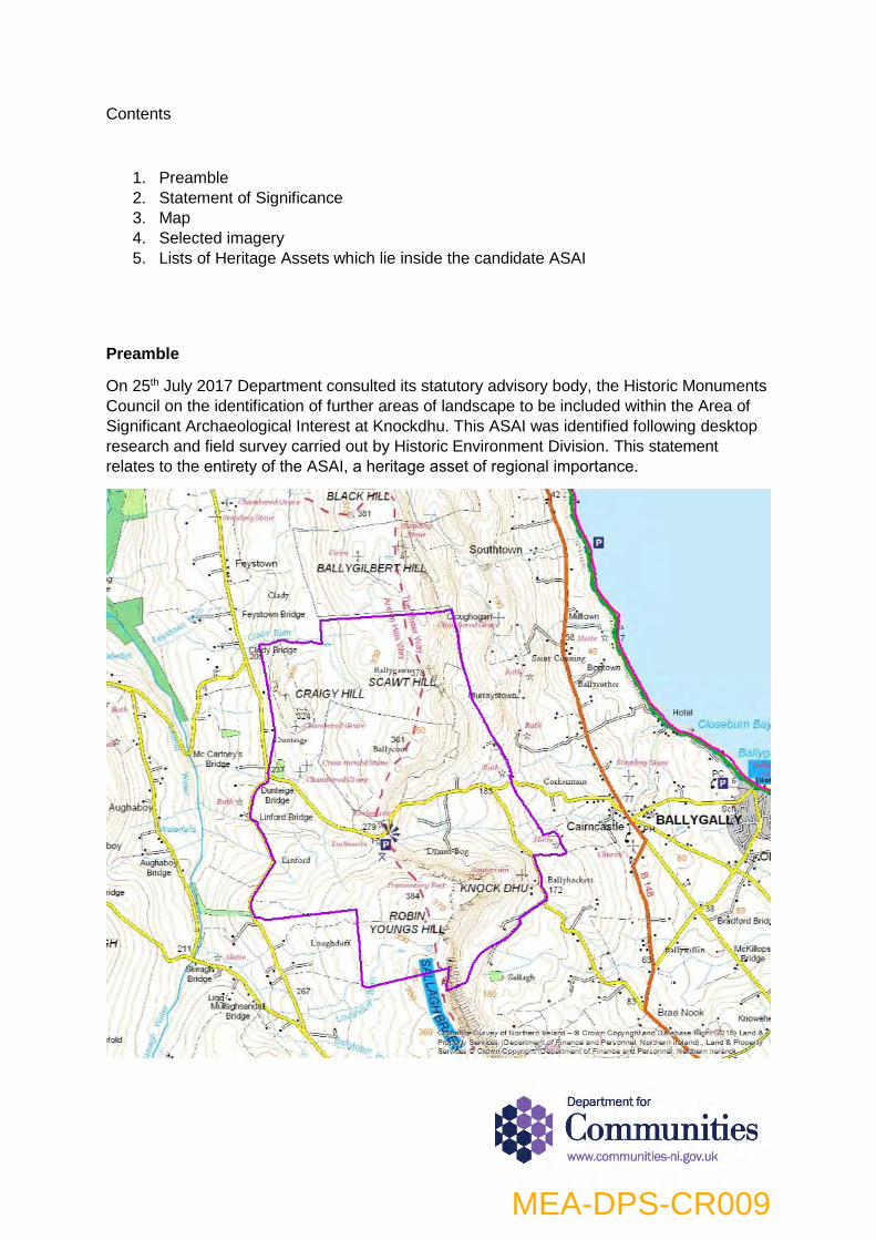
On 25th July 2017 Department consulted its statutory advisory body, the Historic Monuments
Council on the identification of further areas of landscape to be included within the Area of
Significant Archaeological Interest at Knockdhu. This ASAI was identified following desktop
research and field survey carried out by Historic Environment Division. This statement
relates to the entirety of the ASAI, a heritage asset of regional importance.
MEA-DPS-CR009

Statement of Significance
Knockdhu
An additional area of land has been identified for inclusion within the Knockdhu Area of
Significant Archaeological Interest, to the north (focused on Scawt Hill with its scheduled hilltop
cairn) and along the northeast and east of the current designated area.
The unique historic upland landscape of Knockdhu contains a wide array of prehistoric and
historic archaeological sites and monuments. At its southern extent it is dominated by the
dramatically set, scheduled inland promontory fort at Knockdhu, which provides expansive
views over the surrounding landscape. The interactions of this site with the historic landscape,
including far ranging visuals toward other monuments, landforms, seascape and skylines,
including the distinctive upland coastal topography and landscape of the Antrim Plateau as it
meets and visually interacts with the Antrim Coast and Glens, are particularly important.
The Ulster Way, a regionally significant tourism asset which provides a unique public access
to this ASAI, meanders from south to north through the landscape. The many heritage assets
that the area contains have discrete and overlapping settings and their significance is
enhanced by their relationships with each other, with historic routeways and boundaries and
also with the surrounding environment, including its distinctive uplands, waterways and
skylines. The evolution of historic townlands and place names in the district has also been
influenced by natural landscape characteristics, the historic environment and historical
associations.
The rugged, unimproved and dramatic upland landscape which contains a plethora of remains
of historic human activity, the absence of modern development, and the wide ranging vistas,
are key aspects of the character of the ASAI which contribute to its significance.
The landscape of the ASAI is sensitive to development that would adversely affect its
distinctive qualities. The erection of masts, pylons, turbines and associated infrastructure, or
other large scale development including large agricultural sheds or quarrying and mining
activities within this distinctive landscape or adjacent to it may adversely impact the landscape
character and the contribution it makes to the setting, experience and enjoyment of the rich
spectrum of sites and monuments that lie within it.
MEA-DPS-CR009
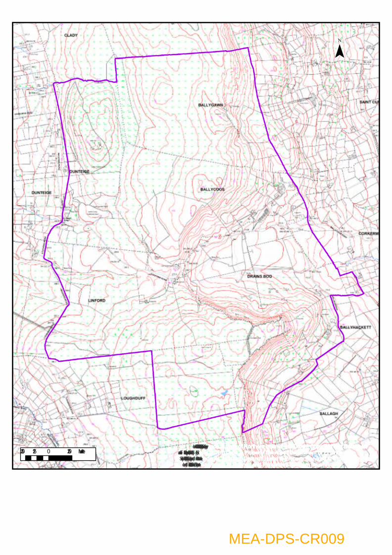
Ordnance Survey of Northern Ireland – © Crown Copyright and DatabaseRight (2016) Land & Property Services (Department of Finance andPersonnel, Northern Ireland)., Land & Property Services © Crown Copyright(Department of Finance and Personnel, Northern Ireland).
¯
250 0 250125 Meters
MEA-DPS-CR009
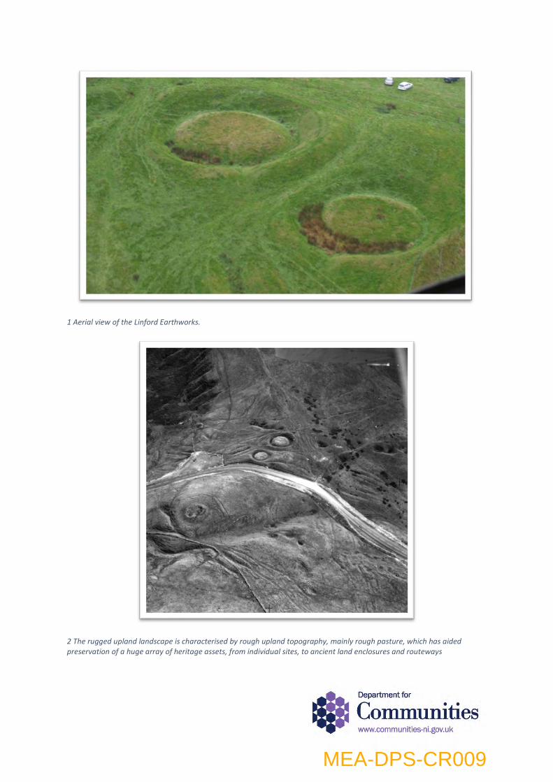
1 Aerial view of the Linford Earthworks.
2 The rugged upland landscape is characterised by rough upland topography, mainly rough pasture, which has aided preservation of a huge array of heritage assets, from individual sites, to ancient land enclosures and routeways
MEA-DPS-CR009
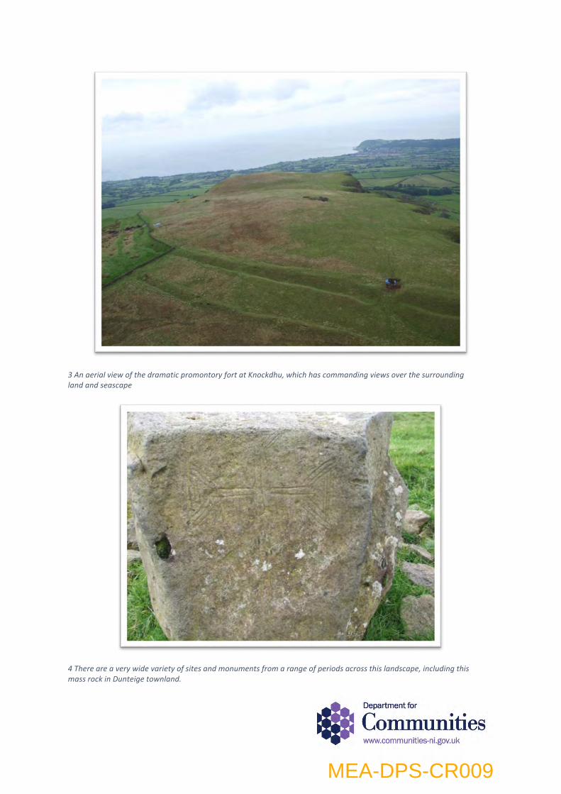
3 An aerial view of the dramatic promontory fort at Knockdhu, which has commanding views over the surrounding land and seascape
4 There are a very wide variety of sites and monuments from a range of periods across this landscape, including this mass rock in Dunteige townland.
MEA-DPS-CR009
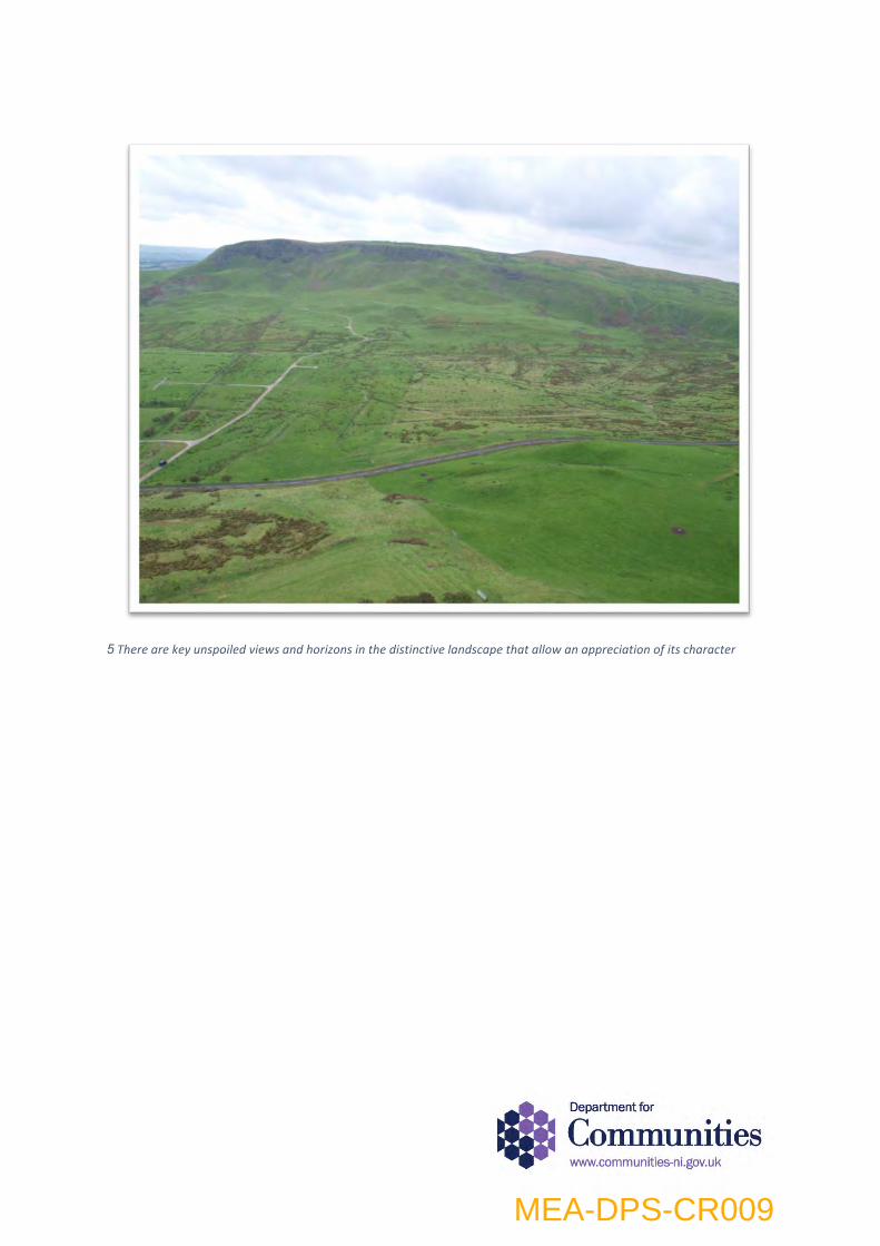
5 There are key unspoiled views and horizons in the distinctive landscape that allow an appreciation of its character
MEA-DPS-CR009
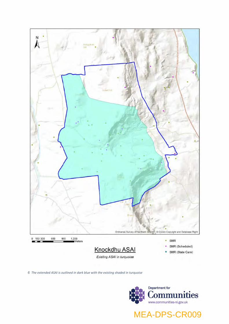
6 The extended ASAI is outlined in dark blue with the existing shaded in turquoise
MEA-DPS-CR009
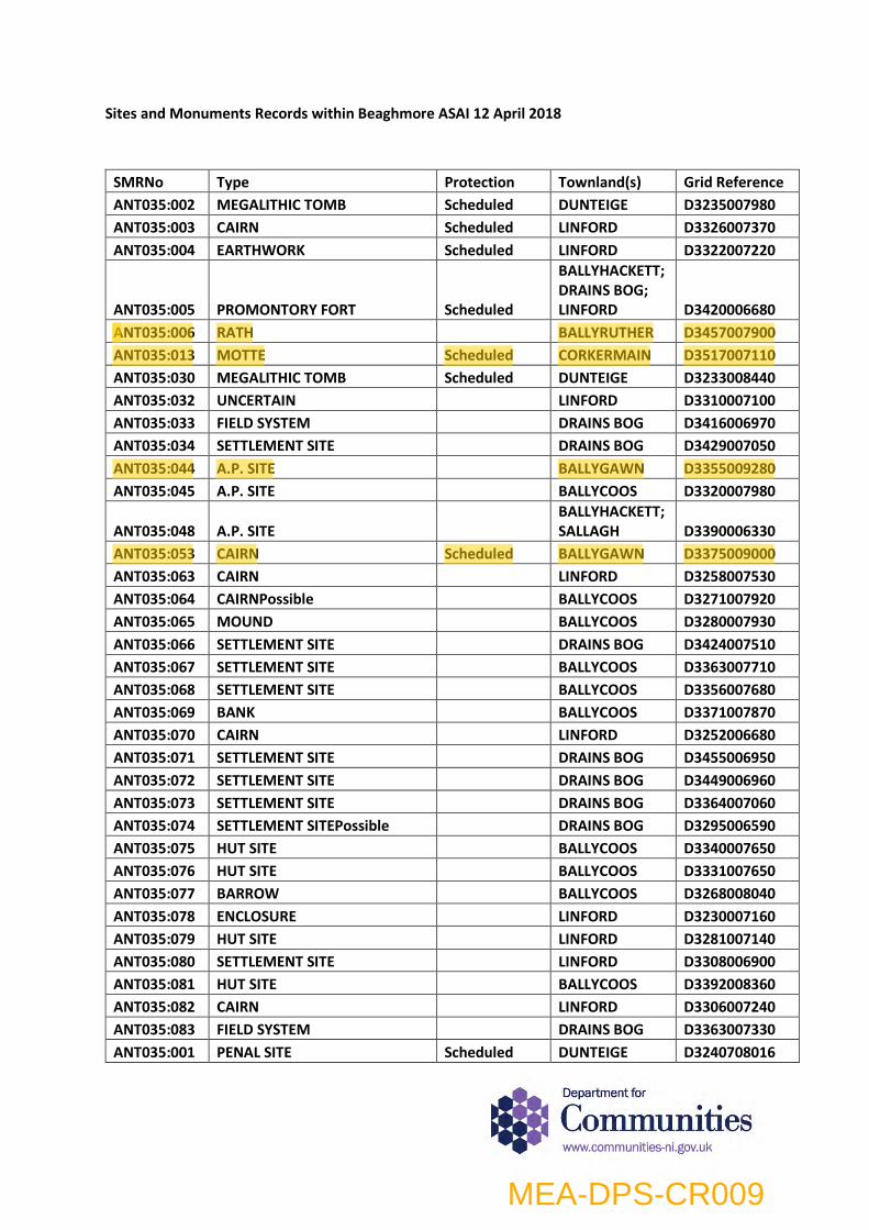
Sites and Monuments Records within Beaghmore ASAI 12 April 2018
SMRNo Type Protection Townland(s) Grid Reference ANT035:002 MEGALITHIC TOMB Scheduled DUNTEIGE D3235007980 ANT035:003 CAIRN Scheduled LINFORD D3326007370 ANT035:004 EARTHWORK Scheduled LINFORD D3322007220
ANT035:005 PROMONTORY FORT Scheduled
BALLYHACKETT; DRAINS BOG; LINFORD D3420006680
ANT035:006 RATH BALLYRUTHER D3457007900 ANT035:013 MOTTE Scheduled CORKERMAIN D3517007110 ANT035:030 MEGALITHIC TOMB Scheduled DUNTEIGE D3233008440 ANT035:032 UNCERTAIN LINFORD D3310007100 ANT035:033 FIELD SYSTEM DRAINS BOG D3416006970 ANT035:034 SETTLEMENT SITE DRAINS BOG D3429007050 ANT035:044 A.P. SITE BALLYGAWN D3355009280 ANT035:045 A.P. SITE BALLYCOOS D3320007980
ANT035:048 A.P. SITE BALLYHACKETT; SALLAGH D3390006330
ANT035:053 CAIRN Scheduled BALLYGAWN D3375009000 ANT035:063 CAIRN LINFORD D3258007530 ANT035:064 CAIRNPossible BALLYCOOS D3271007920 ANT035:065 MOUND BALLYCOOS D3280007930 ANT035:066 SETTLEMENT SITE DRAINS BOG D3424007510 ANT035:067 SETTLEMENT SITE BALLYCOOS D3363007710 ANT035:068 SETTLEMENT SITE BALLYCOOS D3356007680 ANT035:069 BANK BALLYCOOS D3371007870 ANT035:070 CAIRN LINFORD D3252006680 ANT035:071 SETTLEMENT SITE DRAINS BOG D3455006950 ANT035:072 SETTLEMENT SITE DRAINS BOG D3449006960 ANT035:073 SETTLEMENT SITE DRAINS BOG D3364007060 ANT035:074 SETTLEMENT SITEPossible DRAINS BOG D3295006590 ANT035:075 HUT SITE BALLYCOOS D3340007650 ANT035:076 HUT SITE BALLYCOOS D3331007650 ANT035:077 BARROW BALLYCOOS D3268008040 ANT035:078 ENCLOSURE LINFORD D3230007160 ANT035:079 HUT SITE LINFORD D3281007140 ANT035:080 SETTLEMENT SITE LINFORD D3308006900 ANT035:081 HUT SITE BALLYCOOS D3392008360 ANT035:082 CAIRN LINFORD D3306007240 ANT035:083 FIELD SYSTEM DRAINS BOG D3363007330 ANT035:001 PENAL SITE Scheduled DUNTEIGE D3240708016
MEA-DPS-CR009
ANT035:031 STANDING STONE Scheduled LINFORD D3301507486 ANT035:035 SOUTERRAIN Scheduled BALLYHACKETT D3479106859 ANT035:061 FLINT QUARRY Scheduled BALLYCOOS D3366807815
MEA-DPS-CR009

MEA-DPS-CR009

MEA-DPS-CR009
IMAGES IN REFERENCE TO COUNTER REPRESENTATION WITH REGARD TO MEA-DPS-076
IMAGERY RECORDED BY HISTORIC ENVIRONMENT DIVISION, DURING FIELD INSPECTION, 24th May 2017
MEA-DPS-CR009

Fig. 1 View of hollow ways/trackways leading to top of escarpment in the northern extension of the ASAI.
MEA-DPS-CR009
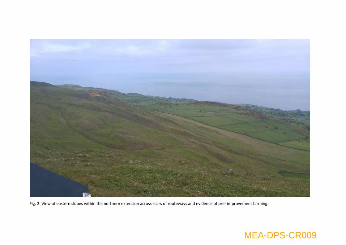
Fig. 2. View of eastern slopes within the northern extension across scars of routeways and evidence of pre- improvement farming.
MEA-DPS-CR009

Fig. 3 View of from top of basalt escarpment looking down slope within the north eastern part of the candidate ASAI. From mid to left of the image
evidence was observed for pre-improvement farming, including cultivation, relict boundaries and routeways
MEA-DPS-CR009