Embed Size (px)
Citation preview

N:\Strategic Planning\Forward Planning\Infrastructure and Release Areas Team\Vanessa Daidone\CARLINGFORD PUBLIC DOMAIN PLAN COVER PAGE.doc
Public Domain Plan CARLINGFORD PRECINCT

CONTENTS
THE HILLS SHIRE COUNCIL - PROJECTS DIVISION
Page 1
Page 1
CA
RLIN
GFO
RD
PR
EC
IN
CT P
UB
LIC
DO
MA
IN
PLA
N
S0
C O N T E N T S
Executive Summary ...................................................................................................... 3
1. Introduction ............................................................................................................ 4
1.1 Purpose ................................................................................................................. 4
1.2 Land to which this Plan applies ................................................................................. 4
1.3 What is the public domain? ...................................................................................... 5
1.4 Relationship to other Plans and Policies ..................................................................... 6
2. Objectives ................................................................................................................ 7
2.1 Vision for the Carlingford Precinct ............................................................................. 7
2.2 Objectives of this Plan ............................................................................................. 7
3. Analysis .................................................................................................................... 8
3.1 Context ................................................................................................................. 8
3.2 Planning and Infrastructure Framework ..................................................................... 8
3.3 Heritage and History ............................................................................................... 9
3.4 Land Uses ............................................................................................................. 11
3.5 Built Form ............................................................................................................. 11
3.6 Access and Circulation ............................................................................................ 12
3.7 Services ............................................................................................................... 12
3.8 Safety .................................................................................................................. 12
3.9 Visual Assessment ................................................................................................. 13
4. Strategic Vision ...................................................................................................... 20
4.1 Access .................................................................................................................. 20
4.1.1 Pedestrian Environment .................................................................................... 20
4.1.2 Cycleways ....................................................................................................... 24
4.1.3 Vehicular Environment ...................................................................................... 26
4.1.4 Public Transport ............................................................................................... 30
4.2 Open Space .......................................................................................................... 32
4.2.1 Young Road Reserve No. 25 .............................................................................. 32
4.2.2 Shirley Street Reserves No. 26 .......................................................................... 33
4.2.3 Lloyds Avenue Reserve No. 27 ........................................................................... 33
4.3 Street furniture, fixtures and fittings ........................................................................ 41
4.4 Stormwater ........................................................................................................... 43
4.5 Street trees and planting ........................................................................................ 44
4.5.1 Street trees, planting and turf areas ................................................................... 44

CONTENTS
THE HILLS SHIRE COUNCIL - PROJECTS DIVISION
Page 2
Page 2
CA
RLIN
GFO
RD
PR
EC
IN
CT P
UB
LIC
DO
MA
IN
PLA
N
S0
4.5.2 Planting .......................................................................................................... 45
4.5.3 Turf Areas ....................................................................................................... 45
4.6 Events and Leased Areas ........................................................................................ 48
4.6.1 Events ............................................................................................................ 48
4.6.2 Leased areas ................................................................................................... 48
4.7 Public Art .............................................................................................................. 49
4.6 Ecologically Sustainable Development ...................................................................... 52
5. Concept Design ....................................................................................................... 53
6. Costing ................................................................................................................... 68
7. Implementation ...................................................................................................... 70
7.1 Introduction .......................................................................................................... 70
7.2 Staging................................................................................................................. 70
Figures
1. Pedestrian pathways 2. Traffic movement 3a. Visual assessment 3b. Visual assessment
4. Proposed paving 5. Pedestrian lighting 6. Cycleways 7. Road pavement 8. Vehicular lighting 9. Public transport 10. Open space treatments
11a. Open space treatments: Young Road Reserve11b. Open space treatments: Shirley Street Reserve11c. Open space treatments: Drainage reserves11d. Open space treatments: Boundary Road R26-111e. Open space treatments: Boundary Road R26-211f. Open space treatments: Drainage Reserve CPLOS112. Signage
13. Street trees14. Public art works15. Paving treatment 116. Paving treatment 217. Paving treatment 318. Kerb and gutter
19. Seats, benches and bollards20. Bins21. Drinking fountain22. Light poles23. Fencing details24. Signs and banners25. Service pit lids
26. Street tree planting
27. General planting details28. Retaining wall details
SECTION 1 - Background
THE HILLS SHIRE COUNCIL - PROJECTS DIVISION
Page 3
Page 3
CA
RLIN
GFO
RD
PR
EC
IN
CT P
UB
LIC
DO
MA
IN
PLA
N
S1
E x e c u t i v e s u m m a r y
The Carlingford Precinct is expected to change markedly in response to
new planning controls which provide for the urban renewal of the area.
As part of the urban renewal process, the Precinct will change from
suburban to urban in character as a result of the introduction of taller
and denser development. The transition from a low density built form
must be supported by an overall plan for the design of public spaces to
ensure that the Carlingford Precinct is a desirable place to live, shop,
work and visit.
There are significant benefits for residents and visitors in providing
public spaces which are attractive, inviting and useable. The renewal
of the Precinct provides an opportunity to guide quality design
outcomes within the public domain. The Hills Shire Council is dedicated
to working with the community and developers to develop the public
domain in a way which meets the needs of current and future residents
of the Precinct.
The development of the Carlingford Precinct Public Domain Plan
involved drawing on the extensive planning work undertaken to date,
as well as on-ground investigations. The on-ground investigations
involved an audit of existing pedestrian pathways, vehicle routes, open
spaces and public areas to better understand the characteristics of the
public domain. Through these processes, a series of priority issues
emerged.
The key issues relating to the public domain in the Carlingford Precinct
are:
1. Improving pedestrian accessibility and circulation
2. Improving the quality of open spaces
3. Providing for cohesive and attractive streetscapes
The public domain works identified in this Plan will be undertaken by
Council and developers as part of the development process. Through
the measures identified in the Plan and in partnership with local
businesses, the community and developers, The Hills Shire Council will
make the Carlingford Precinct exciting and inviting for residents and
visitors alike.

SECTION 1 - Background
THE HILLS SHIRE COUNCIL - PROJECTS DIVISION
Page 4
Page 4
CA
RLIN
GFO
RD
PR
EC
IN
CT P
UB
LIC
DO
MA
IN
PLA
N
S1
S e c t i o n 1 – I n t r o d u c t i o n
This section defines the purpose, scope and structure of the
Carlingford Precinct Public Domain Plan, and its relationship to
other relevant instruments and policies
1.1 Purpose
This Plan is known as the Carlingford Precinct Public Domain Plan. This
Plan serves as a manual to guide the future planning and design of the
public domain within the Carlingford Precinct. It provides an overall
direction for creating public domain spaces that are attractive, safe and
vibrant within the Precinct.
This Plan provides:
An analysis identifying the current and desired future character
of the Carlingford Precinct;
A public domain design framework providing design direction for
future development, including recommended design approaches,
treatments and details;
An estimate of costs for suggested treatments; and
A proposed implementation plan for these recommendations.
This Plan has been prepared by Council to complement the draft Local
Environmental Plan (LEP) and draft Baulkham Hills Development
Control Plan (DCP) Part E Section 22 – Carlingford Precinct. This Public
Domain Plan is part of a suite of planning documents that will guide the
revitalisation of the Precinct for residential and mixed use development.
This Plan is intended to be used by Council, developers and consultants
involved in the development of the Carlingford Precinct and should be
read in conjunction with the documents and policies stated in section
1.4.
It is recommended that this Plan be reviewed regularly to ensure its
continued relevance and usability to the Precinct as it develops in the
future.
1.2 Land to which this Plan applies
This Plan applies to land within the Carlingford Precinct which is located
in the north-western region of Sydney, approximately 23 kilometres
north-west of the Sydney CBD and 8 kilometres from Parramatta.

SECTION 1 - Background
THE HILLS SHIRE COUNCIL - PROJECTS DIVISION
Page 5
Page 5
CA
RLIN
GFO
RD
PR
EC
IN
CT P
UB
LIC
DO
MA
IN
PLA
N
S1
Location Map
The Carlingford Precinct is shown below. The Precinct is bounded by
Pennant Hills Road, Moseley Street and Jenkins Road and is adjacent to
the Hornsby Shire and Parramatta City Council areas.
Carlingford Precinct
1.3 What is the Public Domain?
The public domain is the community realm. It is the space where
civic life takes place. Parks and walking tracks are examples of the
public domain, as are streets, outdoor plazas and meeting places.
For the purposes of this Plan, the public domain is characterised by
all urban and natural elements, structures and publicly accessible

SECTION 1 - Background
THE HILLS SHIRE COUNCIL - PROJECTS DIVISION
Page 6
Page 6
CA
RLIN
GFO
RD
PR
EC
IN
CT P
UB
LIC
DO
MA
IN
PLA
N
S1
spaces within the Precinct.
1.4 Relationship to other Plans and Policies
The Carlingford Precinct Public Domain Plan has been developed using
the following Council Documents and Policies:
Hills 2026
Environment and Leisure Direction (THSC, 2008)
Centres Direction (THSC, 2008)
Safer Shire Strategy 2007-2010 (THSC, 2007)
Disability Action Plan 2005-2010 (THSC, 2004)
Draft North West Subregional Strategy (DOP, 2007)
Metropolitan Strategy (DOP, 2005)
Draft Local Environmental Plan for Carlingford Precinct
Draft Baulkham Hills Development Control Plan Part E Section
22 – Carlingford Precinct
Draft Section 94 Contributions Plan No. 14 – Carlingford Precinct
The Hills Shire Council Bike Plan
Design Guidelines for Subdivisions/Development
Works Specifications for Subdivisions/Development

SECTION 2 – Objectives and Principles
THE HILLS SHIRE COUNCIL - PROJECTS DIVISION
Page 7
Page 7
CA
RLIN
GFO
RD
P
REC
IN
CT
PU
BLIC
D
OM
AIN
PLA
N
S2
S e c t i o n 2 – O b j e c t i v e s
This section of the Plan provides the vision for the Carlingford
Precinct and outlines the objectives which will guide
development of the public domain.
2.1 Vision for the Carlingford Precinct
The Carlingford Precinct is a vibrant, safe and attractive place to
live, work and visit. The Precinct will be characterised by high
quality public domain spaces that provide for an attractive and
cohesive public realm, and contribute to an active street life, as
well as promoting community interaction.
This Plan will assist in achieving the vision for the Carlingford Precinct.
The following section provides for a range of objectives for the Precinct
to be achieved through the implementation of public domain
improvements.
2.2 Objectives of this Plan
This Plan aims to establish a framework of design principles to guide
the implementation of public domain improvements within the Precinct.
Key objectives of this plan are to:
Promote design solutions and finishes that meet the desired
future character for the revitalisation of the Precinct;
Facilitate the creation of high quality public spaces that
encourage social interaction and create a sense of place for
residents and visitors to the Precinct;
Promote the visual and physical integration of the public and
private domains;
Provide appropriate, equitable, safe and convenient access and
egress points for pedestrians; and
Provide for improved pedestrian circulation patterns throughout
the Precinct.

SECTION 3 – Analysis
THE HILLS SHIRE COUNCIL - PROJECTS DIVISION
Page 8
Page 8
CA
RLIN
GFO
RD
PR
EC
IN
CT P
UB
LIC
DO
MA
IN
PLA
N
S3
S e c t i o n 3 – A n a l y s i s
Carlingford Station
Carlingford Village
Shops and apartments on Pennant Hills Road to the south of the Precinct
Carlingford Library
Service station, Pennant Hills Road
Bunnings, Post Office Street
This section of the Plan presents an analysis of the
historical and current context, existing character, land
uses, and access and circulation to identify the existing
character of Carlingford.
3.1 Context
The Hills Shire is a rapidly expanding Local Government Area. The
Shire has experienced significant growth over the past decade
including the redevelopment of established areas for multi-unit
housing and new development within urban release areas. By
2031, the Shire is expected to grow by 100,000 people, with
36,000 additional dwellings to be built and 47,000 additional jobs
to be provided.
The Carlingford Precinct is a 37 hectare site located in the south-
eastern corner of the Shire. The Precinct is the only part of the
Shire which is served by heavy rail, with Carlingford Station
situated in the south-western corner of the Precinct.
Development within the Precinct is characterised by a mix of older
single dwellings, as well as townhouses and apartments which
have been developed since 2001 under the Residential
Development Strategy. Bordering the Precinct to the east and
south are retail and commercial developments including
Carlingford Court shopping centre, Carlingford Village shopping
centre and smaller-scale strip shops and commercial development
along Pennant Hills Road.
Land to the north of the Precinct is predominantly characterised
by low density residential development with some medium density
housing forms such as town houses and villas. Land to the south
and east within the Parramatta City Council area has been
developed for apartments along Pennant Hills Road, which
transitions to single dwelling housing away from the ridge.
A major electricity substation is located to the west of the Precinct
on Jenkins Road. High voltage transmission line towers and
transmission lines cross the Precinct from west to east from the
substation to the south-eastern corner of the Precinct on Pennant
Hills Road.
An educational establishment (James Ruse Agricultural High
School) is located within close proximity of the Precinct. Further
to the west on Pennant Hills Road are Carlingford West Primary
School and Cumberland High School.
3.2 Planning and Infrastructure Framework
A draft Local Environmental Plan (LEP), Development Control Plan
(DCP) and Section 94 Contributions Plan (CP) have been prepared
to provide a planning and infrastructure framework for the future

SECTION 3 – Analysis
THE HILLS SHIRE COUNCIL - PROJECTS DIVISION
Page 9
Page 9
CA
RLIN
GFO
RD
PR
EC
IN
CT P
UB
LIC
DO
MA
IN
PLA
N
S3
Shops, Pennant Hills Road near Marsden Road
Electricity substation, Jenkins Road
Lloyds Avenue
Carlingford Post Office, corner of Post Office Street and Pennant Hills Road, 1920
Bank of New South Wales,
Carlingford, corner of Post Office Street and Pennant Hills Road, c1930
development of the Carlingford Precinct. Development in
accordance with these draft plans will provide for an additional
population of approximately 3,500 people in 2,700 additional
dwellings across a range of dwelling types including high density
apartments, town houses and villas.
The draft LEP provides controls for zoning, floor space ratio and
building height, and the draft DCP outlines detailed controls and
identifies ‘key sites’ for development within the Precinct. The
draft CP identifies key community infrastructure which will be
required as a result of development within the Precinct including
local open space, road and intersection upgrades, an upgrade to
Carlingford Library and a new community centre.
The draft Precinct Planning documents provide for increased
density of development and building heights. The draft DCP
provides controls for landscape design to ensure a high quality
public domain which is compatible with the achievable built forms
and appropriate for the desired future character of the Precinct.
The preparation of a civic design manual or public domain plan to
guide the development of, and to improve the public domain and
streetscape, within centres is identified in both the Environment
and Leisure Direction and the Centres Direction. The public
domain plan for the Carlingford Precinct will assist in achieving the
key objectives of these plans, namely:
C1 Create vibrant centres that meet the needs of the
community
C2 Make centres more attractive places to visit
C3 Make centres accessible to the community
C4 Improve the functioning and viability of existing centres
3.3 Heritage and History The settlement of the Carlingford area dates from the 1860s. The
area was originally known as Mobbs Hill after William Mobbs, an
early settler. Carlingford probably received its name to honour
Lord Carlingford who was Under-secretary of State for the
Colonies from 1857 to 1860. His title is associated with the town
of Carlingford in Ireland. The name was suggested by Frederick
Cox who heard one of his employees describe the similarities
between Mobbs Hill and the scenery of Carlingford in Ireland.
Residents voted for the name in 1886.

SECTION 3 – Analysis
THE HILLS SHIRE COUNCIL - PROJECTS DIVISION
Page 10
Page 10
CA
RLIN
GFO
RD
PR
EC
IN
CT P
UB
LIC
DO
MA
IN
PLA
N
S3
Donald Street
Donald Street Reserve
Post Office Street
Post Office Street
Pennant Hills Road
Parklea Place
Mobbs Hill, Carlingford 1902
Land in Carlingford was used mainly for agriculture, including
orcharding, poultry farms and market gardening. The orchard
owners in the Hills District had lobbied the Government for a
railway line throughout the 1880s to connect the Hills District
orchards with the markets at Flemington without success. As a
result the Carlingford railway line was built privately and opened
on 16 April 1896. The Carlingford line was subsequently
purchased by the State Government in 1899 and the first
Government rail service commenced in 1901. The Carlingford
train service was referred to by local residents as the “Apricot
Express”.
Loading fruit at Carlingford Station, c1915
Growth was minimal in the Carlingford area until after World War
II. The Carlingford Precinct was first urbanised in the 1950s as a
Department of Housing subdivision, however the majority of
urban development occurred from the 1960s onwards.
The Precinct contains one heritage item known as the Carlingford
Stock Feeds located near to the railway station at 1 Thallon
Street, Carlingford.

SECTION 3 – Analysis
THE HILLS SHIRE COUNCIL - PROJECTS DIVISION
Page 11
Page 11
CA
RLIN
GFO
RD
PR
EC
IN
CT P
UB
LIC
DO
MA
IN
PLA
N
S3
High voltage transmission line, Shirley Street Reserve
Carlingford Stock Feeds
3.4 Land uses The Carlingford Precinct is characterised by a mix of residential,
commercial, and community land uses (refer Plan 2). As noted
above, the Precinct contains a mixture of low density detached
housing, as well as town houses, villas and apartment buildings.
Commercial and retail development within the Precinct consists of
a small area of mixed commercial and retail development located
on the western side of Pennant Hills Road between the
intersections of Carlingford Road and Marsden Road. Uses in this
location include a liquor shop, restaurants and Bunnings
Warehouse hardware store. To the north of this group of shops is
a service station and a second service station is located at the
corner of Jenkins and Pennant Hills Road.
In terms of existing community facilities, the Carlingford Branch
Library and the Carlingford First Scouts hall are located in
Boundary Road. A number of privately-owned child care centres
are located within the Precinct.
3.5 Built Form
The built form of the Precinct consists predominantly of single
storey residential dwellings of brick veneer construction. A
majority of the houses were constructed in two phases during the
50s and 60s, which generally have deep front setbacks and are
situated on large allotments with an average of 920m2 in the
Residential 2(a1) zone and 782m2 for Residential 2(a2). These
large lots have enabled trees to be planted or retained which has
resulted in the leafy garden character of the Precinct.
Since the rezoning of the Precinct in 2001, the character of the
built form has changed with the construction of apartment
buildings of between two and eight storeys in height and town
houses up to three storeys in height throughout the Precinct.
Existing apartment development is concentrated in the southern
part of the Precinct south of Post Office Street on Post Office
Street, Lloyds Avenue, Pennant Hills Road, with some

SECTION 3 – Analysis
THE HILLS SHIRE COUNCIL - PROJECTS DIVISION
Page 12
Page 12
CA
RLIN
GFO
RD
PR
EC
IN
CT P
UB
LIC
DO
MA
IN
PLA
N
S3
developments on Jenkins Road and Thallon Street. In the
northern part of the Precinct, aside from apartment development
on Pennant Hills Road opposite Carlingford Court and at the
corner of Young Road and Post Office Street, new development
has been predominantly in the form of town houses and villas.
3.6 Access and Circulation
The Precinct is bounded by Pennant Hills Road to the east and
south, Jenkins Road to the west and Moseley Street to the north.
Pennant Hills Road is a classified road, however there are no
major collector roads within the Precinct and the road network is
dominated by local and minor collector roads (refer Plan 2).
Footpaths line the perimeter of the Precinct along Pennant Hills
Road, Jenkins Road and Moseley Street and are provided in parts
of Post Office Street, Lloyds Avenue, Shirley Street, Donald Street
and Thallon Street (refer Plan 1). Footpaths vary in quality and
width, with some new paths constructed outside new apartment
developments in the southern part of the Precinct. Aside from
these footpaths there are limited existing formal pedestrian
access ways to shops, public open space and public transport
within the Precinct, with the exception of the pedestrian path
parallel to Carlingford Station which links the railway station to
Boundary Road (north). In addition, no formal off-road cycleways
are available within the Precinct.
Pedestrian circulation within the Precinct is largely characterised
by movement to and from the train station and Pennant Hills
Road, as well as movement to and from the Carlingford Court and
Carlingford Village shopping centres. The definition of pedestrian
access ways is poor.
3.7 Services
Services within the Precinct are predominantly provided above
ground, including street power and street lighting. In addition, a
132kV high voltage power transmission line crosses the Precinct
from west to east from the substation on Jenkins Road to the
south-eastern corner of the Precinct on Pennant Hills Road.
Overhead services may restrict street tree planting and as such
the draft DCP provides for the undergrounding of both street pole
services and high voltage power lines.
3.8 Safety
The mixture of residential, commercial, retail and community uses
means that the safety and security of visitors and residents to the
Precinct is an important consideration for this Plan.
Presently activity is focussed around the railway station and shops
in the vicinity of Lloyds Avenue, as well as along Pennant Hills
Road opposite Carlingford Village and Carlingford Court.
However, links between these activity nodes are limited and

SECTION 3 – Analysis
THE HILLS SHIRE COUNCIL - PROJECTS DIVISION
Page 13
Page 13
CA
RLIN
GFO
RD
PR
EC
IN
CT P
UB
LIC
DO
MA
IN
PLA
N
S3
poorly defined. Pedestrians currently travel from the northern
end of Boundary Road and Shirley Street via the Shirley Street
Reserve to reach the station. Whilst a narrow concrete pathway
starts at Boundary Road and follows the fence along the outside of
the railway corridor adjacent to the Reserve, there is no formal
path through the Reserve from Shirley Street to link with this
pathway. Due to inadequate lighting, as well as limited passive
surveillance of this route, a safe environment is not provided for
pedestrians.
Accordingly, this Plan promotes the creation of pedestrian spaces
with better lighting and paving to ensure that these areas are
safe.
Unformed path from Shirley Street to Carlingford Station
Concrete path from Boundary Road to Carlingford Station
3.9 Visual assessment A visual assessment of the Precinct was undertaken to understand
the existing visual and aesthetic characteristics of the Precinct.
The visual assessment has informed the preparation of the
principles and strategies presented in Section 4 of this Plan which
will guide the character, quality and functioning of development
within the public domain. The results of the visual assessment
are presented in Plans 3a and 3b.

SECTION 3 – Analysis
THE HILLS SHIRE COUNCIL - PROJECTS DIVISION
Page 14
Page 14
CA
RLIN
GFO
RD
PR
EC
IN
CT P
UB
LIC
DO
MA
IN
PLA
N
S3

SECTION 3 – Analysis
THE HILLS SHIRE COUNCIL - PROJECTS DIVISION
Page 15
Page 15
CA
RLIN
GFO
RD
PR
EC
IN
CT P
UB
LIC
DO
MA
IN
PLA
N
S3

SECTION 3 – Analysis
THE HILLS SHIRE COUNCIL - PROJECTS DIVISION
Page 16
Page 16
CA
RLIN
GFO
RD
PR
EC
IN
CT P
UB
LIC
DO
MA
IN
PLA
N
S3

SECTION 3 – Analysis
THE HILLS SHIRE COUNCIL - PROJECTS DIVISION
Page 17
Page 17
CA
RLIN
GFO
RD
PR
EC
IN
CT P
UB
LIC
DO
MA
IN
PLA
N
S3
1. Corner of Moseley Street and Pennant Hills Road facing south
2. Young Road Reserve
3. Pennant Hills Road streetscape facing north
4. Tanderra Avenue street trees
5. Pennant Hills Road streetscape facing south
6. Existing fencing
7. Tanderra Avenue street trees
8. Tanderra Avenue street trees
9. Parklea Place streetscape facing south
10. Moseley Street streetscape facing west
11. Young Road streetscape facing north
12. Bus stop on Pennant Hills Road northbound
13. Pedestrian access to development at 780 Pennant Hills Road
14. Donald Street

SECTION 3 – Analysis
THE HILLS SHIRE COUNCIL - PROJECTS DIVISION
Page 18
Page 18
CA
RLIN
GFO
RD
PR
EC
IN
CT P
UB
LIC
DO
MA
IN
PLA
N
S3

SECTION 3 – Analysis
THE HILLS SHIRE COUNCIL - PROJECTS DIVISION
Page 19
Page 19
CA
RLIN
GFO
RD
PR
EC
IN
CT P
UB
LIC
DO
MA
IN
PLA
N
S3
1. Lloyds Avenue Reserve retaining wall
2. Pennant Hills Road facing north near corner Jenkins Road
3. Footpath corner of Post Office Street and Pennant Hills Road
4. Bus stop, Post Office Street
5. Railway station overbridge
6. Lloyds Avenue streetscape facing west
7. Existing dwelling, Shirley Street
8. Car park entry, development at 1-9 Shirley Street
9. Bus stop adjacent to electricity substation on Jenkins Road facing
south
10. Shirley Street Reserve
11. Carlingford Stock Feeds adjacent to railway line
12. Street trees, Boundary Road facing south
13. Existing strip commercial on Pennant Hills Road
14. Corner of Post Office Street and Pennant Hills Road facing south

SECTION 4 – Strategic Vision
THE HILLS SHIRE COUNCIL - PROJECTS DIVISION
Page 20
Page 20
CA
RLIN
GFO
RD
PR
EC
IN
CT P
UB
LIC
DO
MA
IN
PLA
N
S4
S e c t i o n 4 – S t r a t e g i c V i s i o n This section establishes a series of principles and strategies to
guide the character, quality and functioning of development
within the public domain of the Carlingford Precinct. These
guidelines will form part of an overall urban design framework
for the Precinct and support the provisions of relevant planning
policies and plans.
4.1 Access
Pedestrian movement
Pedestrian movement
Porphyry paving
Porphyry stone for banding
4.1.1 Pedestrian Environment
Pedestrian access principles:
Link all public and private pedestrian walking
networks into an integrated system;
Enhance and improve the walking environment;
Encourage more use of the public domain for
pedestrian movement;
Improve major pedestrian nodes and crossing points
to minimise waiting times;
Provide adequate width of pedestrian footpath to
allow for the expected pedestrian volumes throughout
the Precinct;
Allow for regional pedestrian access links to
Parramatta, Epping, North Rocks and West Ryde; and
Provide adequate pedestrian lighting.
Recommendations:
Implement three levels of paving through the
precinct, based on expected pedestrian volumes and
aesthetic expectations, as follows:
o Treatment 1 specifies full footpath width
porphyry paving;
o Treatment 2 specifies 2.5m width plain
concrete footpath with porphyry banding; and
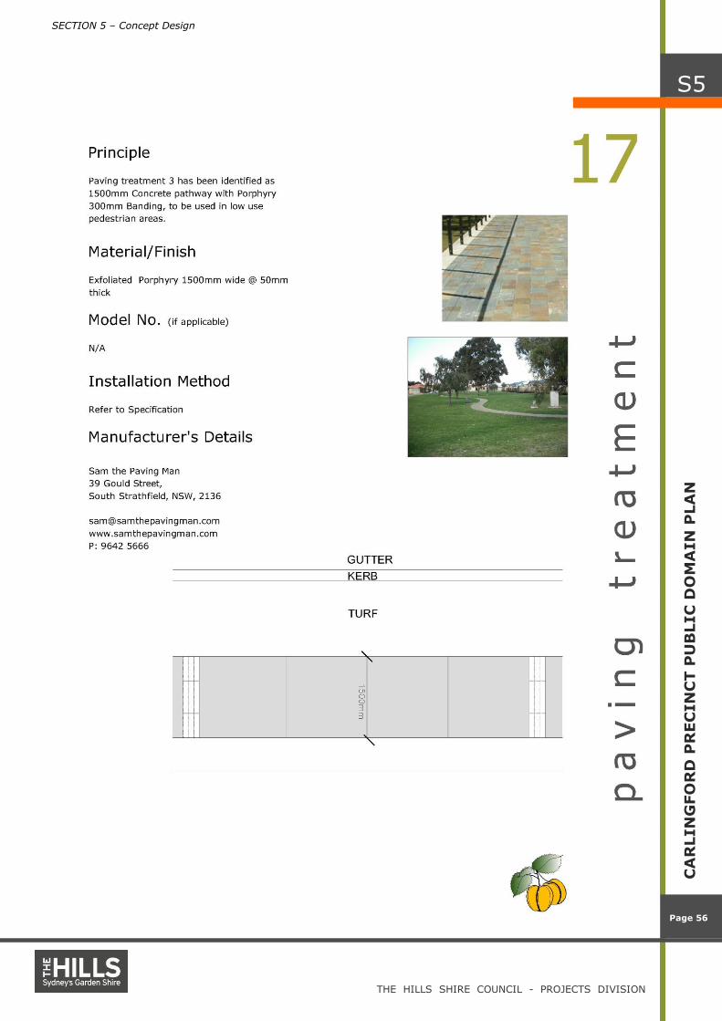
o Treatment 3 specifies 1.5m width plain
concrete footpath with porphyry banding.
Identify and implement raised pedestrian crossing
points and phase traffic signals appropriately at
crossing points to reduce waiting times, including:
o Mid street crossing points on Post Office
Street; and
o One mid street crossing point on Jenkins Road
to facilitate pedestrian movement to and from
the transport hub.
Provide opportunities for improved pedestrian access
in the Carlingford Precinct through land acquisition or
Development Control Plan controls, including:

SECTION 4 – Strategic Vision
THE HILLS SHIRE COUNCIL - PROJECTS DIVISION
Page 21
Page 21
CA
RLIN
GFO
RD
PR
EC
IN
CT P
UB
LIC
DO
MA
IN
PLA
N
S4
Concrete paving
o Development conditions that facilitate
pedestrian movement from private to public
domain; and
o Development conditions that encourages the
development to address the street frontage.
Identify pedestrian links between the Carlingford
Precinct and surrounding areas:
o Provide pedestrian access links from other
centres via open space.
Provide pedestrian lighting to create safe and
amenable access throughout the Precinct, including:
o P1 level lighting in accordance with the
Australian Standard 1158 for major
intersections and high trafficked areas;
o P2 level lighting in accordance with Australian
Standard 1158 for major pedestrian links to
the Precinct; and
o P3 level lighting in accordance with the
Australian Standard 1158 for lower level
pedestrian links.
Plans:
Refer to Plans 4 and 5

SECTION 4 – Strategic Vision
THE HILLS SHIRE COUNCIL - PROJECTS DIVISION
Page 22
Page 22
CA
RLIN
GFO
RD
PR
EC
IN
CT P
UB
LIC
DO
MA
IN
PLA
N
S4

SECTION 4 – Strategic Vision
THE HILLS SHIRE COUNCIL - PROJECTS DIVISION
Page 23
Page 23
CA
RLIN
GFO
RD
PR
EC
IN
CT P
UB
LIC
DO
MA
IN
PLA
N
S4

SECTION 4 – Strategic Vision
THE HILLS SHIRE COUNCIL - PROJECTS DIVISION
Page 24
Page 24
CA
RLIN
GFO
RD
PR
EC
IN
CT P
UB
LIC
DO
MA
IN
PLA
N
S4
Cyclists
Cycleway example
Cycleway signage example
Shared pedestrian and cycle facilities
4.1.2 Cycleways
Cycleway access principles:
Link all existing cycleways within the Carlingford Precinct to
the regional cycleway network through and to local schools;
Provide on-road and off-road cycleway facilities; and
Provide cycle storage at major transport and shopping hubs.
Recommendations:
Implement off-road cycleways at the following locations:
o Shirley Street (E side) full length
o Jenkins Road (E and W sides) full length
o Post Office Street (S side)
o Moseley Street (N side); and
Refer to concept design for line marking and typical plan and
sections.
Plans:
Refer to Plan 6
Cycle storage

SECTION 4 – Strategic Vision
THE HILLS SHIRE COUNCIL - PROJECTS DIVISION
Page 25
Page 25
CA
RLIN
GFO
RD
PR
EC
IN
CT P
UB
LIC
DO
MA
IN
PLA
N
S4

SECTION 4 – Strategic Vision
THE HILLS SHIRE COUNCIL - PROJECTS DIVISION
Page 26
Page 26
CA
RLIN
GFO
RD
PR
EC
IN
CT P
UB
LIC
DO
MA
IN
PLA
N
S4
Vehicular environment
Vehicular environment
Vehicular environment
4.1.3 Vehicular Environment
Vehicular access principles:
Provide a completely integrated road network that
connects to surrounding road networks and services the
Carlingford Precinct;
Provide a safe and efficient road network for the
community to utilise;
Provide public parking facilities that allow for the expected
numbers of vehicles in the Carlingford Precinct;
Develop roads that minimise conflict between cyclists,
pedestrians and vehicles;
Provide adequate lighting for vehicular movements within
the precinct; and
Provide sympathetic treatments to all roundabouts.
Recommendations:
Implement road improvements in accordance with the
capital works road improvement program;
Implement traffic improvements in accordance with the
recommendations of the Traffic Committee;
Implement vehicular lighting improvements in accordance
with the recommendations of the Traffic Committee;
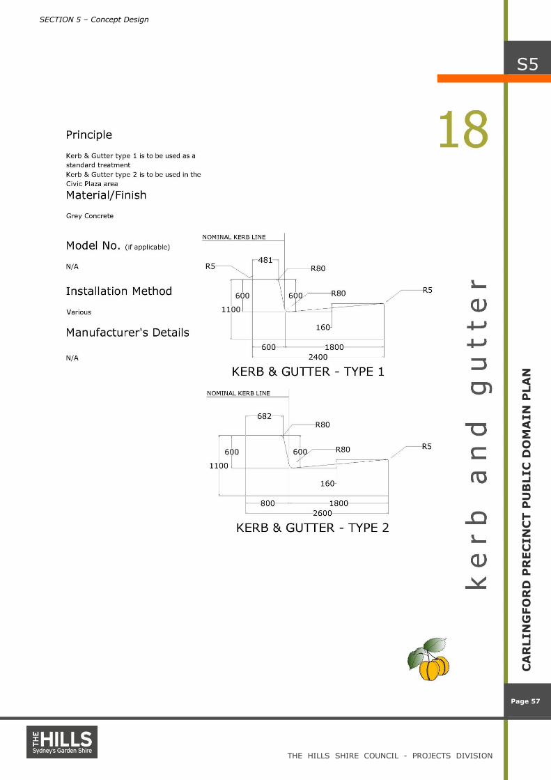
Implement Kerb and Gutter as specified:
o Kerb and Gutter 1 is typical Kerb and Gutter as
identified in the concept design; and
o Kerb and Gutter 2 is 200mm wide Kerb and typical
Gutter as identified in the concept design.
Implement V3 level lighting in accordance with Australian
Standard 1158 for all heavily utilised pedestrian areas,
including:
o Boundary Road between Post Office Street and
Pennant Hills Road;
o Jenkins Road between Pennant Hills Road and Post
Office Street;
o Parklea Place;
o James Street and Thallon Street; and
o Pennant Hills Road between Jenkins Road and Post
Office Street.
Implement V5 level lighting in accordance with Australian
Standard 1158 for all major roads, including:
o Post Office Street, full length;
o Donald Street, full length;
o Young Road, full length; and
o Shirley Street, full length.
Implement P4 level lighting in accordance with Australian
Standard 1158 for all Local roads, including:
o Jenkins Road, full length;
o Moseley Street, full length; and
o Post Office Street, full length.

SECTION 4 – Strategic Vision
THE HILLS SHIRE COUNCIL - PROJECTS DIVISION
Page 27
Page 27
CA
RLIN
GFO
RD
PR
EC
IN
CT P
UB
LIC
DO
MA
IN
PLA
N
S4
Plans:
Refer to Plans 7 and 8

SECTION 4 – Strategic Vision
THE HILLS SHIRE COUNCIL - PROJECTS DIVISION
Page 28
Page 28
CA
RLIN
GFO
RD
PR
EC
IN
CT P
UB
LIC
DO
MA
IN
PLA
N
S4

SECTION 4 – Strategic Vision
THE HILLS SHIRE COUNCIL - PROJECTS DIVISION
Page 29
Page 29
CA
RLIN
GFO
RD
PR
EC
IN
CT P
UB
LIC
DO
MA
IN
PLA
N
S4

SECTION 4 – Strategic Vision
THE HILLS SHIRE COUNCIL - PROJECTS DIVISION
Page 30
Page 30
CA
RLIN
GFO
RD
PR
EC
IN
CT P
UB
LIC
DO
MA
IN
PLA
N
S4
Private buses
Heavy rail
Taxi
4.1.4 Public Transport
Public Transport principles:
Encourage the use of public transport to and from
Carlingford Precinct.
Recommendations:
In collaboration with the state government, encourage the
construction of the Epping to Parramatta Rail Link;
Provide adequate facilities at bus stops through the
precinct;
Maintain and promote taxi ranks in Carlingford precinct; and
Provide adequate vehicle drop-off points through
Carlingford Precinct to encourage the use of public
transport.
Plans:
Refer to Plan 9

SECTION 4 – Strategic Vision
THE HILLS SHIRE COUNCIL - PROJECTS DIVISION
Page 31
Page 31
CA
RLIN
GFO
RD
PR
EC
IN
CT P
UB
LIC
DO
MA
IN
PLA
N
S4

SECTION 4 – Strategic Vision
THE HILLS SHIRE COUNCIL - PROJECTS DIVISION
Page 32
Page 32
CA
RLIN
GFO
RD
PR
EC
IN
CT P
UB
LIC
DO
MA
IN
PLA
N
S4
4.2 Open Space
Play spaces and Structures for all groups
Iconic play structures
Seating and shade structures
Open Space principles:
Link existing and potential open space areas;
Provide a safe and amenable environment;
Encourage the community to use open space by
improving the aesthetic quality; and
Locate incidental play elements at appropriate places
along streets within road reserve and setbacks.
Recommendations:
Undergrounding of high voltage power lines and use of
easements as open space;
Combining easements;
Create a Civic Square; and
Install play equipment in safe and appropriate locations.
Plans:
Refer to Plan 10
4.2.1 Young Road Reserve No. 25
Open Space principles:
Link to streetscape as unified public space;
Provide green backdrop to views to the north; and
Provide a visual focus / sculptural element.
Recommendations:
Provide a substantial play space;
Provide a grassed area;
Provide sitting areas;
Provide path link to the street; and
Provide a sculpture.
Plans:
Refer to Plan 11a

SECTION 4 – Strategic Vision
THE HILLS SHIRE COUNCIL - PROJECTS DIVISION
Page 33
Page 33
CA
RLIN
GFO
RD
PR
EC
IN
CT P
UB
LIC
DO
MA
IN
PLA
N
S4
Play spaces
Sculptural play elements
Appropriately scaled play structures
4.2.2 Shirley Street Reserves No. 26
Open Space principles:
Encourage passive recreation within the park;
Provide a safe and amenable environment; and
Encourage the community to use the park by improving the
aesthetic quality.
Recommendations:
Improve pedestrian footpath network;
Provide additional garden beds and tree plantings; and
Provide a high quality play structure.
Plans:
Refer to Plan 11b
4.2.3 Lloyds Avenue Reserve No. 27
Open Space principles:
Integrate Lloyds Avenue to park with surface treatments that are
harmonious in colour and texture; and
Screen off Pennant Hills Road with green walls.
Plans:
Refer to Plan 10

SECTION 4 – Strategic Vision
THE HILLS SHIRE COUNCIL - PROJECTS DIVISION
Page 34
Page 34
CA
RLIN
GFO
RD
PR
EC
IN
CT P
UB
LIC
DO
MA
IN
PLA
N
S4

SECTION 4 – Strategic Vision
THE HILLS SHIRE COUNCIL - PROJECTS DIVISION
Page 35
Page 35
CA
RLIN
GFO
RD
PR
EC
IN
CT P
UB
LIC
DO
MA
IN
PLA
N
S4

SECTION 4 – Strategic Vision
THE HILLS SHIRE COUNCIL - PROJECTS DIVISION
Page 36
Page 36
CA
RLIN
GFO
RD
PR
EC
IN
CT P
UB
LIC
DO
MA
IN
PLA
N
S4

SECTION 4 – Strategic Vision
THE HILLS SHIRE COUNCIL - PROJECTS DIVISION
Page 37
Page 37
CA
RLIN
GFO
RD
PR
EC
IN
CT P
UB
LIC
DO
MA
IN
PLA
N
S4

SECTION 4 – Strategic Vision
THE HILLS SHIRE COUNCIL - PROJECTS DIVISION
Page 38
Page 38
CA
RLIN
GFO
RD
PR
EC
IN
CT P
UB
LIC
DO
MA
IN
PLA
N
S4

SECTION 4 – Strategic Vision
THE HILLS SHIRE COUNCIL - PROJECTS DIVISION
Page 39
Page 39
CA
RLIN
GFO
RD
PR
EC
IN
CT P
UB
LIC
DO
MA
IN
PLA
N
S4

SECTION 4 – Strategic Vision
THE HILLS SHIRE COUNCIL - PROJECTS DIVISION
Page 40
Page 40
CA
RLIN
GFO
RD
PR
EC
IN
CT P
UB
LIC
DO
MA
IN
PLA
N
S4

SECTION 4 – Strategic Vision
THE HILLS SHIRE COUNCIL - PROJECTS DIVISION
Page 41
Page 41
CA
RLIN
GFO
RD
PR
EC
IN
CT P
UB
LIC
DO
MA
IN
PLA
N
S4
4.3 Street Furniture, Fixtures and Fittings
Seating and shade structures
Picnic table and benches
Bench
Furniture, fixtures and fittings principles:
Improve the aesthetic of the precinct by providing good
quality furniture, fixtures and fittings;
Provide functional furniture, fixtures and fittings to the
precinct; and
Provide unique and associative furniture fixtures and
fittings to the precinct.
Recommendations:
Provide up-lights to trees along Post Office Street;
Provide gateway signage at the two major vehicular
entrances to the Carlingford Precinct;
Provide directional signage at the public transport hub to
identify the places of interest within the Precinct;
Provide informational signage to the transport hub to
identify useful information about the Precinct; and
Refer to Section 5 for the suite of furniture, fixtures and
fittings, including signage for the Precinct.
Plans:
Refer to Plan 12

SECTION 4 – Strategic Vision
THE HILLS SHIRE COUNCIL - PROJECTS DIVISION
Page 42
Page 42
CA
RLIN
GFO
RD
PR
EC
IN
CT P
UB
LIC
DO
MA
IN
PLA
N
S4

SECTION 4 – Strategic Vision
THE HILLS SHIRE COUNCIL - PROJECTS DIVISION
Page 43
Page 43
CA
RLIN
GFO
RD
PR
EC
IN
CT P
UB
LIC
DO
MA
IN
PLA
N
S4
4.4 Stormwater
Bioswale Example
Bioswale example
Gross Pollutant Trap example
Gross Pollutant Trap example
Stormwater principles:
Improve water quality through the provision of water quality
management techniques;
Reduce the runoff from hard areas by recharging the water
table; and
Implement Carlingford Stormwater Study and Management
Plan.
Recommendations:
Provide bio-swales on the verge, where practical, in the
following locations:
o Post Office Street
o Boundary Road;
Provide gross pollutant traps at the following location:
o Jenkins Road; and
Provide water capture for re-use infrastructure at the
following locations:
o Young Road Reserve;
o Shirley Street Reserve; and
o Boundary Road Reserve.
Plans:
Refer to Plans 11a, 11b, 11c, 11d, 11e & 11f.
Rain water storage tank example Rain water storage tank example

SECTION 4 – Strategic Vision
THE HILLS SHIRE COUNCIL - PROJECTS DIVISION
Page 44
Page 44
CA
RLIN
GFO
RD
PR
EC
IN
CT P
UB
LIC
DO
MA
IN
PLA
N
S4
4.5 Street Trees, Planting and Turf Areas
Corymbia ficifolia
Eucalyptus microcorys
Magnolia ‘Little Gem’
Livistonia australis
Stenocarpus sinuatus
4.5.1 Street Trees
Street tree principles:
Improve the aesthetic of the Precinct by providing avenue
plantings;
Provide street trees that have been utilised as street trees
successfully by Council in the past; and
Provide street trees that minimise impact on paving, services
and other infrastructure.
Recommendations:
Provide the following species:
Jenkins Road
Corymbia ficifolia and Eucalyptus microcorys.
James and Thallon Streets
Magnolia ‘Little Gem’, Livistona australis, Stenocarpus sinuatus,
Brachyton acerifolius and Waterhousia floribunda.
Post Office Street
Hymenosporum flavum, Fraxinus angustifolia ‘Raywood’ and
Pistacia chinensis.
Moseley Street
Jacaranda mimosifolia and Callistemon viminalis.
Pennant Hills Road
Eucalyptus saligna and Eucalyptus scoparia.
Tanderra Street and Boundary Road
Prunus cerasifera ‘Nigra’, Platanus x acerifolia and Tristainiopsis.
Donald Street
Gordonia axillaris, Melaleuca linarifolius and Callistemon saligna.
Parklea Place
Ginko bilboa, Acmena smithii and Lagerstroemia ‘Natchez’.
Paul Place, Correy Place and Cassandra Place
Ginko bilboa.
Shirley Street
Gordonia axillaris, Sapium sebiferium, Waterhousia floribunda
and Elaeocarpus reticulatus.
Young Road
Alphitonia excelsa, Celtis australis and Fraxinius griffthii.
Plans:
Refer to Plan 12

SECTION 4 – Strategic Vision
THE HILLS SHIRE COUNCIL - PROJECTS DIVISION
Page 45
Page 45
CA
RLIN
GFO
RD
PR
EC
IN
CT P
UB
LIC
DO
MA
IN
PLA
N
S4
Waterhousia floribunda
Hymenosporum flavum
Plantanus x acerifolia
Jacaranda mimosifolia
Tristainiopsis
Gordonia axillaris
4.5.2 Planting
Understorey planting principles:
Improve the aesthetic of the Precinct by providing understorey
plantings;
Utilise drought resistant plant species;
Provide plant material that will minimise maintenance
requirements; and
Improve the aesthetic of the Precinct by providing avenue
plantings.
Recommendations:
Provide the following treatments:
Post Office Street, Boundary Road, Tanderra Avenue
Provide Planting Treatment 1, consisting of: Myoporum
parvifolium, Lomandra ‘Tanika’, Lomandra ‘Little Con’, Lomandra
‘Silver Grace’, Westringia ‘Lilac and Lace’ and Rhagodia
spinescens var deltophylla.
Pennant Hills Road
Provide Planting Treatment 2, consisting of: Chrysocephalum
apiculatum, Gazania spp., Dianella caerulea and Lomandra ‘Silver
Grace’.
Other Streets
Additional species can be used within the areas prescribed, if
approved by Council.
4.5.3 Turf Areas
Turf principles:
Improve the aesthetic and amenity of the Precinct by providing
turfed areas;
Utilise drought and pollution resistant turf species; and
Provide turf species that will minimise maintenance
requirements.
Recommendations:
Provide turf areas consisting of Cynodon dactylon (varieties
should be drought and pollution tolerant), along all streets and in
Reserves.
Cynodon dactylon - Couch Grass

SECTION 4 – Strategic Vision
THE HILLS SHIRE COUNCIL - PROJECTS DIVISION
Page 46
Page 46
CA
RLIN
GFO
RD
PR
EC
IN
CT P
UB
LIC
DO
MA
IN
PLA
N
S4
Eucalyptus scoparia
Ginkgo biloba
Lagerstroemia indica x ’Natchez’
Planting Treatment 1 Planting Treatment 2
Myoporum parvifolium
Themeda ‘Mingo’
Westringia ‘Lilac and
Lace’
Lomandra ‘Little Con'
Lomandra ‘Tanika’
Rhagodia spinescens var
deltophylla
Chrysocephalum apiculatum
Gazania spp.
Dianella caerulea
Lomandra ‘Silver Grace’

SECTION 4 – Strategic Vision
THE HILLS SHIRE COUNCIL - PROJECTS DIVISION
Page 47
Page 47
CA
RLIN
GFO
RD
PR
EC
IN
CT P
UB
LIC
DO
MA
IN
PLA
N
S4

SECTION 4 – Strategic Vision
THE HILLS SHIRE COUNCIL - PROJECTS DIVISION
Page 48
Page 48
CA
RLIN
GFO
RD
PR
EC
IN
CT P
UB
LIC
DO
MA
IN
PLA
N
S4
4.6 Events and Leased Areas
Public Event – The Hills
Public Event – The Hills
4.6.1 Events
Events principles:
Provide public spaces within Carlingford to allow the
congregation of the community to celebrate and enjoy
events and festivals;
Provide adequate facilities at each location identified for
the provision of food and entertainment; and
Provide adequate facilities.
Recommendations:
Provide an events stage area within the Reserves; and
Provide adequate electrical, water and temporary
shelters at each events location identified on the plan.
Outdoor dining
Outdoor dining
Outdoor dining
4.6.2 Leased Areas
Leased Areas principles:
Provide opportunities within the public space, for
leasing and licensing of space for commercial activities;
and
Provide adequate facilities to encourage outdoor dining
throughout Carlingford Precinct.
Recommendations:
Provide seating areas within the road reserve to
encourage on-street trading.
SECTION 4 – Strategic Vision
THE HILLS SHIRE COUNCIL - PROJECTS DIVISION
Page 49
Page 49
CA
RLIN
GFO
RD
PR
EC
IN
CT P
UB
LIC
DO
MA
IN
PLA
N
S4
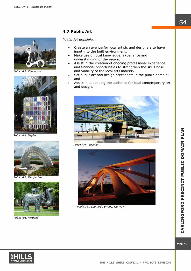
4.7 Public Art
Public Art, Vancouver
Public Art, Naples
Public Art, Tampa Bay
Public Art, Portland
Public Art principles:
Create an avenue for local artists and designers to have
input into the built environment;
Make use of local knowledge, experience and
understanding of the region;
Assist in the creation of ongoing professional experience
and financial opportunities to strengthen the skills base
and viability of the local arts industry;
Set public art and design precedents in the public domain;
and
Assist in expanding the audience for local contemporary art
and design.
Public Art, Phoenix
Public Art, Leonardo Bridge, Norway

SECTION 4 – Strategic Vision
THE HILLS SHIRE COUNCIL - PROJECTS DIVISION
Page 50
Page 50
CA
RLIN
GFO
RD
PR
EC
IN
CT P
UB
LIC
DO
MA
IN
PLA
N
S4
Recommendations:
Implement the following list of artworks:
Artwork
No. Site Art and Design Issues
1 Pennant Hills Road Sculptural Gateway Icon
Sufficient space for
sculptures
2 Old Library / New Youth
Precinct
Temporary installation on
forecourt or banner poles
– laser cut metal, wood
panels, fibreglass,
lighting
Developed through youth
workshops
3 James Street Civic Plaza
Sculptural landscaping
Sculptural furniture
Lighting
Freestanding sculptures
Paving Art
Spatial design to needs
to be accommodate high
volume of traffic
4 New Bus Train and Taxi
Interchange
New media installations
Sculptural furniture
Lighting
Freestanding sculptures
Paving Art
Support high pedestrian
traffic use
Safety and visibility
5 Various Reserves
New media installations
Sculptural furniture
Landscaping
Lighting
Freestanding Sculptures
Paving Art
Support events based
activities (multifunctional
space)
Safety and visibility
6 Post Office Street
western end
Freestanding Sculpture
Lighting Location on private land
7 Train Bridge
Sculptural Wall (with
lighting)
Paving a Sculptural / 3D
relief with components
fixed to structure (laser
cut metal, painted wood)
Safety and visibility
Contribute to creation of
links. Good visibility for
cars and pedestrians.
High profile marking of a
new link
Developed in tandem
with bridge design choice
Retrofitting an existing
structure
Plans:
Refer to Plan 14

SECTION 4 – Strategic Vision
THE HILLS SHIRE COUNCIL - PROJECTS DIVISION
Page 51
Page 51
CA
RLIN
GFO
RD
PR
EC
IN
CT P
UB
LIC
DO
MA
IN
PLA
N
S4

SECTION 4 – Strategic Vision
THE HILLS SHIRE COUNCIL - PROJECTS DIVISION
Page 52
Page 52
CA
RLIN
GFO
RD
PR
EC
IN
CT P
UB
LIC
DO
MA
IN
PLA
N
S4
4.8 ESD
ESD principles:
Encourage the use of ESD principles in the design of public
spaces.
Recommendations:
Utilise techniques to minimise the effects of the development
on the environment. These techniques could include:
o Using plantation timber products;
o Using endemic plant species where appropriate;
o Sourcing local materials;
o Using recycled materials where appropriate; and
o Encouraging non-polluting forms of transport.
SECTION 5 – Concept Design
THE HILLS SHIRE COUNCIL - PROJECTS DIVISION
Page 53
Page 53
CA
RLIN
GFO
RD
PR
EC
IN
CT P
UB
LIC
DO
MA
IN
PLA
N
S5
S e c t i o n 5 – C o n c e p t D e s i g n This section presents design solutions and details for the Carlingford Precinct that
address a range of specific public domain issues including, paving hierarchies and
materials, street tree planting and street furniture.

SECTION 5 – Concept Design
THE HILLS SHIRE COUNCIL - PROJECTS DIVISION
Page 54
Page 54
CA
RLIN
GFO
RD
PR
EC
IN
CT P
UB
LIC
DO
MA
IN
PLA
N
S5

SECTION 5 – Concept Design
THE HILLS SHIRE COUNCIL - PROJECTS DIVISION
Page 55
Page 55
CA
RLIN
GFO
RD
PR
EC
IN
CT P
UB
LIC
DO
MA
IN
PLA
N
S5
SECTION 5 – Concept Design
THE HILLS SHIRE COUNCIL - PROJECTS DIVISION
Page 56
Page 56
CA
RLIN
GFO
RD
PR
EC
IN
CT P
UB
LIC
DO
MA
IN
PLA
N
S5
SECTION 5 – Concept Design
THE HILLS SHIRE COUNCIL - PROJECTS DIVISION
Page 57
Page 57
CA
RLIN
GFO
RD
PR
EC
IN
CT P
UB
LIC
DO
MA
IN
PLA
N
S5

SECTION 5 – Concept Design
THE HILLS SHIRE COUNCIL - PROJECTS DIVISION
Page 58
Page 58
CA
RLIN
GFO
RD
PR
EC
IN
CT P
UB
LIC
DO
MA
IN
PLA
N
S5

SECTION 5 – Concept Design
THE HILLS SHIRE COUNCIL - PROJECTS DIVISION
Page 59
Page 59
CA
RLIN
GFO
RD
PR
EC
IN
CT P
UB
LIC
DO
MA
IN
PLA
N
S5

SECTION 5 – Concept Design
THE HILLS SHIRE COUNCIL - PROJECTS DIVISION
Page 60
Page 60
CA
RLIN
GFO
RD
PR
EC
IN
CT P
UB
LIC
DO
MA
IN
PLA
N
S5

SECTION 5 – Concept Design
THE HILLS SHIRE COUNCIL - PROJECTS DIVISION
Page 61
Page 61
CA
RLIN
GFO
RD
PR
EC
IN
CT P
UB
LIC
DO
MA
IN
PLA
N
S5

SECTION 5 – Concept Design
THE HILLS SHIRE COUNCIL - PROJECTS DIVISION
Page 62
Page 62
CA
RLIN
GFO
RD
PR
EC
IN
CT P
UB
LIC
DO
MA
IN
PLA
N
S5

SECTION 5 – Concept Design
THE HILLS SHIRE COUNCIL - PROJECTS DIVISION
Page 63
Page 63
CA
RLIN
GFO
RD
PR
EC
IN
CT P
UB
LIC
DO
MA
IN
PLA
N
S5
SECTION 5 – Concept Design
THE HILLS SHIRE COUNCIL - PROJECTS DIVISION
Page 64
Page 64
CA
RLIN
GFO
RD
PR
EC
IN
CT P
UB
LIC
DO
MA
IN
PLA
N
S5

SECTION 5 – Concept Design
THE HILLS SHIRE COUNCIL - PROJECTS DIVISION
Page 65
Page 65
CA
RLIN
GFO
RD
PR
EC
IN
CT P
UB
LIC
DO
MA
IN
PLA
N
S5

SECTION 5 – Concept Design
THE HILLS SHIRE COUNCIL - PROJECTS DIVISION
Page 66
Page 66
CA
RLIN
GFO
RD
PR
EC
IN
CT P
UB
LIC
DO
MA
IN
PLA
N
S5

SECTION 5 – Concept Design
THE HILLS SHIRE COUNCIL - PROJECTS DIVISION
Page 67
Page 67
CA
RLIN
GFO
RD
PR
EC
IN
CT P
UB
LIC
DO
MA
IN
PLA
N
S5

SECTION 6 – Costings
THE HILLS SHIRE COUNCIL - PROJECTS DIVISION
Page 68
Page 68
CA
RLIN
GFO
RD
PU
BLIC
DO
MA
IN
PLA
N
S6
S e c t i o n 6 – C o s t i n g
This section presents the cost estimates for the public domain
works identified in this Plan including the value of the concept
designs presented in Section 5.
DESCRIPTION RATE UNIT Planning & Design
15 %
Preliminaries
10 %
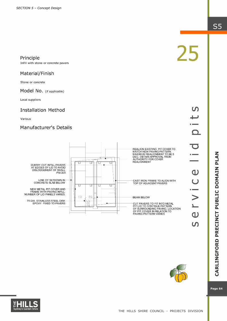
Service Adjustments – Major service networks and pits present, requiring infill pit lids
$300 M2
Service Adjustments – Moderate service networks and pits present, requiring level adjustments of the pit lids and frames – Only on footpaths
$100 M2
Service Adjustments – Minor service adjustments to existing pit lids and frames, only damaged pit lids and frames to be replaced – Only on footpaths
$50 M2
Allow for bio-swales in the landscaped areas including stormwater pits, pipes and drainage media
$55 M2
Minor repair and replacement of broken or failing road infrastructure
$100 M2
Major upgrade of road infrastructure including: road reconstruction, Kerb & Gutter replacement and construction of raised pedestrian thresholds on standard sub-base
$100 M2
Major upgrade of road infrastructure including: road reconstruction, Kerb & Gutter replacement and construction of raised pedestrian thresholds on Concrete sub-base
$270 M2
Full width porphyry paving with concrete sub-base
$250 M2
Concrete footpath/Cycleway 2.5m width with porphyry banding @ 6m centres / 500mm width.
$130 M2
Concrete footpath 1.5m width with porphyry banding @ 6m centres / 300mm width.
$120 M2
Furniture, Fixtures & Fittings – High Pedestrian use - Multi-function Poles every 15m, Seats, Bins, Bollards, Bus Shelter, and Play Space item.
$215 M2
Furniture, Fixtures & Fittings – Medium Pedestrian use - Multi-function Poles every 30m, Seats, Bins, Bollards, and Play Space item.
$115 M2
Furniture, Fixtures & Fittings – Low Pedestrian use - Multi-function Poles every 45m, Seats, Bins, Bollards
$60 M2
Landscape Treatment – Including tree planting and understorey planting in full width paving
$100 M2
Landscape Treatment – Including tree planting and understorey planting in 2.5m wide paving
$200 M2
Landscape Treatment – Including tree planting and understorey planting in 1.5m wide paving
$100 M2
Landscape Treatment – Including tree planting and Turf
$60 M2
Contingency 15% 15 %

SECTION 6 – Costings
THE HILLS SHIRE COUNCIL - PROJECTS DIVISION
Page 69
Page 69
CA
RLIN
GFO
RD
PU
BLIC
DO
MA
IN
PLA
N
S6
CARLINGFORD PUBLIC DOMAIN PLAN - DRAFT ESTIMATE
ITEM DESCRIPTION UNIT QUANTITY RATE AMOUNT
A Boundary Rd m2 7100 $832,160
B Cassandra Place m2 997 $200,253
C Correy Place m2 997 $200,253
D Donald Street m2 6975 $1,289,987
E James Street m2 2432 $2,589,711
F Jenkins Road m2 11574 $2,938,899
G Lloyds Avenue m2 3887 $595,342
H Moseley Street m2 11342 $3,480,596
I Parklea Place m2 2531 $610,398
J Paul Place m2 997 $249,731
K Pennant Hills Road m2 4536 $1,130,526
L Post Office Street m2 11690 $3,751,583
M Shirley Street m2 6680 $2,195,545
N Tanderra Avenue m2 5372 $832,160
O Thallon Street m2 5334 $5,174,628
P Young Street m2 4396 $979,785
Q
CPOS1 Shirley Street Reserve m2 2089 $652,706
CPLOS1 m2 4650 $459,500
CPLOS2 m2 1941 $354,650
CPLOS3 m2 1449 $341,970
R Young Street Reserve R 25 m2 2242 $712,900
S Boundary Road Reserve R 26 m2 6039 $1,500,000
T Lloyds Avenue Reserve R 27 m2 4462 $500,000
TOTAL m2 109,712 $288 $31,573,283

SECTION 7 – Implementation
THE HILLS SHIRE COUNCIL - PROJECTS DIVISION
Page 70
CA
RLIN
GFO
RD
PU
BLIC
DO
MA
IN
PLA
N
S7
Page 70
S e c t i o n 7 – I m p l e m e n t a t i o n This section will guide the implementation of this public domain
plan. A proposed schedule of planning, design and construction
works will ensure the staging and implementation of the
recommendations made within the Plan.
7.1 Introduction
The guiding visions and recommendations contained with in this Plan
form a basis from which detail design works, public consultation,
sponsoring/partnering arrangements and fund sources may be
established for the long-term implementation of public domain
improvements.
Achievement of the objectives and measures identified in the Plan will
require a coordinated management approach by The Hills Shire
Council, and on-going commitment to a program of construction,
trialling, maintenance, review and improvement.
The staging and implementation of proposed works will be influenced
by:
Availability and allocation of funding for maintenance and new
works;
Formation of partnerships with representatives from the corporate
sector and/or state and federal government organisations;
Community expectations and engagement;
Political and socio-economic forces at the state and local level;
Council priorities, for example, the need to address risks and
liabilities such as uneven pavement surfaces;
Road re-construction works, including Boulevard treatments for Post
Office Street, Tanderra Avenue and Boundary Street; and
Future RTA funding for the widening of Pennant Hills Road.
7.2 Staging
A combination of short and long-term measures should be established
for the implementation of public domain improvements. It is
envisaged that short-term measures will address immediate priorities
and form a basis for on-going or future works. Proposed measures
include:
Short-term (1-3 years)
Coordinated outcomes of this Public Domain Plan with the current
Development Applications for the precinct.
Undertake a pilot project for paving and the selection of Porphyry
Stone pavement colours and finishes.
Incorporate outcomes of this Plan into the Local Environment Plan
and Development Control Plan for the Precinct to ensure consistent
approaches and enforceable requirements for developers to
contribute to the installation of public domain finishes to public open
space and at the frontage of new developments.

SECTION 7 – Implementation
THE HILLS SHIRE COUNCIL - PROJECTS DIVISION
Page 71
CA
RLIN
GFO
RD
PU
BLIC
DO
MA
IN
PLA
N
S7
Page 71
Improve pedestrian amenity access and equity along key streets
including Post office Road Moseley Street, Tanderra Avenue and
Boundary Road by developing a detailed Master-plan for these roads
that includes proposals for paving, lighting street tree planting and
incidental play spaces.
Undertake the preparation of a signage manual to guide the design
and implementation of future signage throughout the public domain.
Undertake the preparation of a lighting manual to guide the type
and location of proposed lighting within the public domain.
Undertake a tendering process to select a preferred contractor for
the supply, installation and on-going maintenance of paving
materials.
Develop a paving policy for the precinct that establishes detailed
locations for various paving treatments and contains details relating
to material selection, supply and installation.
Develop detail design concepts and documentation of key areas
such as the Civic precinct proposed to be adjacent to the upgraded
train station.
Develop a detailed public art installation plan and commission major
installations in the designated areas.
Allocate funding within the Capital Works Program for the upgrade
of parks and reserves.
Long-term (3 – 5 years)
Design and document the upgrade of all the parks and reserves
within the precinct.
Design and document improvements for secondary pavement
treatments and street tree planting.
Implement traffic devices that encourage a pedestrian-friendly
environment to the key public areas.
Implement measures to consolidate pedestrian linkages through
private land.
Design and document plans for historic interpretative information
around the existing train station.