Embed Size (px)
Citation preview

Design Guidelines for
Gravity Systems in Soil Type 1
February 2017

Design Guideline for
Gravity Systems in Soil Type 1 February 2017
For information or additional copies of this report contact: Wastewater Management Section Physical address: 243 Israel Rd SE, Tumwater, WA 98501 Mailing address: PO Box 47824, Olympia, WA 98504-7824
Phone: 360.236.3330 FAX: 360.236.2257 Website: www.doh.wa.gov/wastewater Email: [email protected]
John Wiseman Secretary of Health
For persons with disabilities, this document is available upon request in other formats. To submit a request, please call 1-800-525-0127 (TDD/TTY call 711).
Para personas discapacitadas, este documento está disponible a su pedido en otros formatos. Para hacer su pedido llame al 1-800-525-0127 (TDD/TTY call 711).
DOH 337-003

Design Guideline for Gravity Systems in Soil Type 1 Effective Date: February 2017
DOH 337-003 Page 3 of 15
Contents Page
Purpose .............................................................................................................................................4
Background ......................................................................................................................................4
Applicability ....................................................................................................................................4
How to Use this Guidance ...............................................................................................................5
Regulatory Criteria ...........................................................................................................................5
Hydrogeologic Conditions ...............................................................................................................6
Sources for Hydrogeologic Information ..........................................................................................7
Definitions ......................................................................................................................................11
Well Logs .......................................................................................................................................13
Figures
Figure 1 – Table IV Chapter 246-272A .....................................................................................4
Figure 2 – Regulatory Criteria Flow Chart ................................................................................6
Figure 3 – Vadose Zone Materials for Unconfined Aquifers ....................................................9
Figure 4 – Hydrogeology Flow Chart ......................................................................................10

Design Guideline for Gravity Systems in Soil Type 1 Effective Date: February 2017
DOH 337-003 Page 4 of 15
Guideline for Using Conventional Gravity Distribution On-site Sewage Systems in Soil Type 1
Purpose
The purpose of this guideline is to provide assistance to local health jurisdictions (LHJ) when applying the five criteria listed in On-site Sewage Systems, WAC 246-272A-0234 (6), for permitting a gravity subsurface soil absorption system (SSAS) in Type 1 soils. The guidance should be used in conjunction with local knowledge of the site-specific conditions.
Background
Type 1 soils are defined in Table V in WAC 246-272A as “gravelly and very gravelly coarse sands, all extremely gravelly soils excluding soil types 5 and 6, and all soil types with greater than or equal to 90% rock fragments”. A gravity SSAS is typically not permitted in Type 1 soils because soils with a high percentage of rock generally have a poor capability for treating pathogens that are present in septic tank effluent. Soils with a high percentage of rock often have higher infiltration rates and less soil. This can result in less than adequate treatment of pathogens.
Failure of an on-site system to properly treat the pathogens is difficult to detect because it does not result in immediate problems like those caused by hydraulic failure. Public health impacts from incomplete treatment of pathogens can be significant if it results in contamination of a current or potential source of drinking water. Washington State Department of Health recognizes that certain site conditions may mitigate a lack of treatment typically found with a gravity SSAS in a Type 1 soil. These include an arid climate, deep soil, and a protected aquifer.
Applicability
This guideline applies to Type 1 soils with a minimum vertical separation of at least 60 inches. These are sites where Treatment Level C with pressure distribution is required by rule. Figure 1 is highlighted to show where the guideline is applicable.
Figure 1 Chapter 246-272A WAC Table VI
Treatment Component Performance Levels and Method of Distribution Vertical Separation
in inches Soil Type
1 2 3-6
12 < 18 A - pressure with timed dosing
B - pressure with timed dosing
B - pressure with timed dosing
≥ 18 < 24 B - pressure with timed dosing
B - pressure with timed dosing
B - pressure with timed dosing
≥ 24 < 36 B - pressure with timed dosing
C - pressure E – pressure
≥ 36 < 60 B - pressure with timed dosing
E - pressure E – gravity
≥ 60 C – pressure E - gravity E – gravity
Design Guideline for Gravity Systems in Soil Type 1 Effective Date: February 2017
DOH 337-003 Page 5 of 15
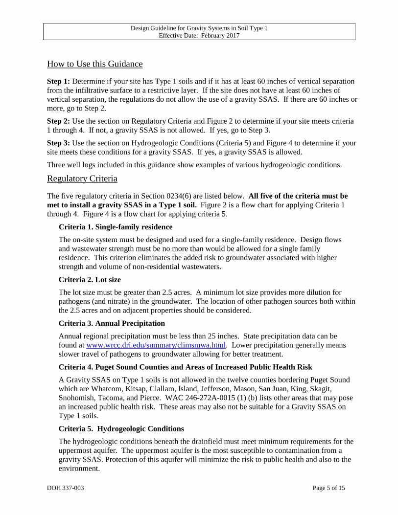
How to Use this Guidance
Step 1: Determine if your site has Type 1 soils and if it has at least 60 inches of vertical separation from the infiltrative surface to a restrictive layer. If the site does not have at least 60 inches of vertical separation, the regulations do not allow the use of a gravity SSAS. If there are 60 inches or more, go to Step 2.
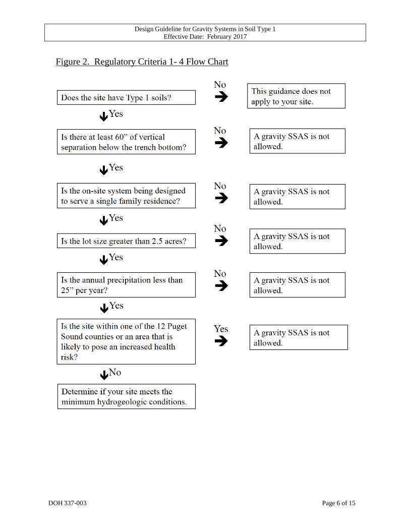
Step 2: Use the section on Regulatory Criteria and Figure 2 to determine if your site meets criteria 1 through 4. If not, a gravity SSAS is not allowed. If yes, go to Step 3.
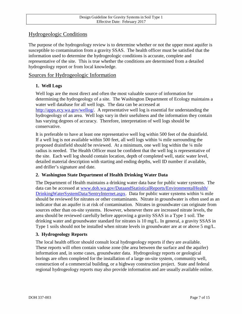
Step 3: Use the section on Hydrogeologic Conditions (Criteria 5) and Figure 4 to determine if your site meets these conditions for a gravity SSAS. If yes, a gravity SSAS is allowed.
Three well logs included in this guidance show examples of various hydrogeologic conditions.
Regulatory Criteria
The five regulatory criteria in Section 0234(6) are listed below. All five of the criteria must be met to install a gravity SSAS in a Type 1 soil. Figure 2 is a flow chart for applying Criteria 1 through 4. Figure 4 is a flow chart for applying criteria 5.
Criteria 1. Single-family residence The on-site system must be designed and used for a single-family residence. Design flows and wastewater strength must be no more than would be allowed for a single family residence. This criterion eliminates the added risk to groundwater associated with higher strength and volume of non-residential wastewaters.
Criteria 2. Lot size The lot size must be greater than 2.5 acres. A minimum lot size provides more dilution for pathogens (and nitrate) in the groundwater. The location of other pathogen sources both within the 2.5 acres and on adjacent properties should be considered.
Criteria 3. Annual Precipitation Annual regional precipitation must be less than 25 inches. State precipitation data can be found at www.wrcc.dri.edu/summary/climsmwa.html. Lower precipitation generally means slower travel of pathogens to groundwater allowing for better treatment.
Criteria 4. Puget Sound Counties and Areas of Increased Public Health Risk A Gravity SSAS on Type 1 soils is not allowed in the twelve counties bordering Puget Sound which are Whatcom, Kitsap, Clallam, Island, Jefferson, Mason, San Juan, King, Skagit, Snohomish, Tacoma, and Pierce. WAC 246-272A-0015 (1) (b) lists other areas that may pose an increased public health risk. These areas may also not be suitable for a Gravity SSAS on Type 1 soils.
Criteria 5. Hydrogeologic Conditions The hydrogeologic conditions beneath the drainfield must meet minimum requirements for the uppermost aquifer. The uppermost aquifer is the most susceptible to contamination from a gravity SSAS. Protection of this aquifer will minimize the risk to public health and also to the environment.
Design Guideline for Gravity Systems in Soil Type 1 Effective Date: February 2017
DOH 337-003 Page 6 of 15
Figure 2. Regulatory Criteria 1- 4 Flow Chart
Design Guideline for Gravity Systems in Soil Type 1 Effective Date: February 2017
DOH 337-003 Page 7 of 15
Hydrogeologic Conditions
The purpose of the hydrogeology review is to determine whether or not the upper most aquifer is susceptible to contamination from a gravity SSAS. The health officer must be satisfied that the information used to determine the hydrogeologic conditions is accurate, complete and representative of the site. This is true whether the conditions are determined from a detailed hydrogeology report or from local knowledge.
Sources for Hydrogeologic Information
1. Well Logs Well logs are the most direct and often the most valuable source of information for determining the hydrogeology of a site. The Washington Department of Ecology maintains a water well database for all well logs. The data can be accessed at http://apps.ecy.wa.gov/wellog/. A representative well log is essential for understanding the hydrogeology of an area. Well logs vary in their usefulness and the information they contain has varying degrees of accuracy. Therefore, interpretation of well logs should be conservative.
It is preferable to have at least one representative well log within 500 feet of the drainfield. If a well log is not available within 500 feet, all well logs within ¼ mile surrounding the proposed drainfield should be reviewed. At a minimum, one well log within the ¼ mile radius is needed. The Health Officer must be confident that the well log is representative of the site. Each well log should contain location, depth of completed well, static water level, detailed material description with starting and ending depths, well ID number if available, and driller’s signature and date.
2. Washington State Department of Health Drinking Water Data The Department of Health maintains a drinking water data base for public water systems. The data can be accessed at www.doh.wa.gov/DataandStatisticalReports/EnvironmentalHealth/ DrinkingWaterSystemData/SentryInternet.aspx. Data for public water systems within ¼ mile should be reviewed for nitrates or other contaminants. Nitrate in groundwater is often used as an indicator that an aquifer is at risk of contamination. Nitrates in groundwater can originate from sources other than on-site systems. However, whenever there are increased nitrate levels, the area should be reviewed carefully before approving a gravity SSAS in a Type 1 soil. The drinking water and groundwater standard for nitrates is 10 mg/L. In general, a gravity SSAS in Type 1 soils should not be installed when nitrate levels in groundwater are at or above 5 mg/L.
3. Hydrogeology Reports The local health officer should consult local hydrogeology reports if they are available. These reports will often contain vadose zone (the area between the surface and the aquifer) information and, in some cases, groundwater data. Hydrogeology reports or geological borings are often completed for the installation of a large on-site system, community well, construction of a commercial building, or a highway construction project. State and federal regional hydrogeology reports may also provide information and are usually available online.

Design Guideline for Gravity Systems in Soil Type 1 Effective Date: February 2017
DOH 337-003 Page 8 of 15
Determine the Upper-Most Aquifer
The first step in the hydrogeologic review is to determine the location of the upper most aquifer. The upper most aquifer is defined as the shallowest saturated zone that can yield sufficient water to support a beneficial use. A beneficial use can be drinking water, irrigation, recharge to surface water or recharge to a deeper aquifer. The upper most aquifer can be shallow, deep, perched, confined, or unconfined. Some saturated zones have an insufficient quantity of water to support a beneficial use and do not meet the definition of an aquifer. These zones are isolated from an aquifer and can be seasonal or due to irrigation. Before deciding if a saturated zone meets the definition of an aquifer, the health officer should have knowledge as to whether the saturated zone can or cannot support a beneficial use. The health officer should also know whether contamination of these zones will pose a risk to public health. If the health officer is unsure, they should consider the saturated zone the uppermost aquifer.
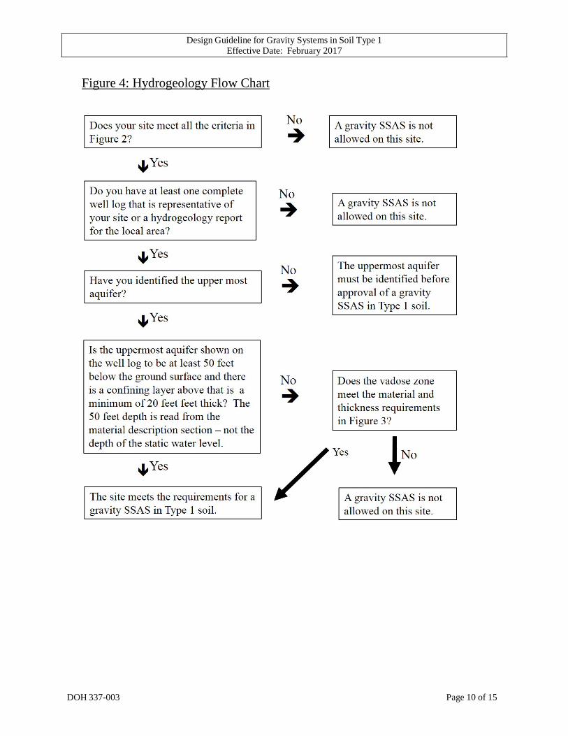
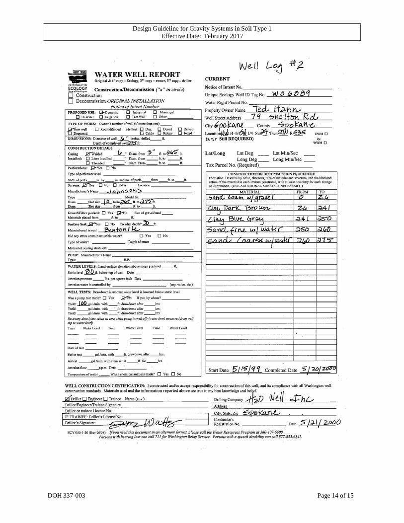
A representative well log is often the best source of information for locating the upper most aquifer. Locate the upper most aquifer by finding the first mention of “water” or “wet” in the “description of material” section (the term “moist” usually does not indicate a saturated zone). Generally, this will be the uppermost aquifer unless it meets the requirements for perched or seasonal zone as described above. On Well Log #1 (page 13), the upper most aquifer is from 8 to 129 feet. On Well Log #2 (page 14), the upper most aquifer extends from 250 to 275 feet. On Well Log #3 (page 15), the upper most aquifer begins at 170 feet.
Confined and Unconfined Aquifers
The second step in the hydrogeology review is to determine if the uppermost aquifer is a confined or unconfined aquifer. For the purpose of this guidance, the terms “confined” and “unconfined” aquifer will be used. In actual settings, many “confined” aquifers are only semi-confined.
Confined Aquifer Sites
A confined aquifer has an overlying impervious layer which separates the aquifer from the surface. A confined aquifer will provide physical protection to the aquifer from surface sources of contamination. When a well is drilled into the confined aquifer, water rises in the well to some level above the lowermost level of the confining layer. This is called the static water level and is shown on the well log.
Confining layers are identified by their density, thickness, soil texture, level of saturation, and gravel content. Several confining layers can exist above an aquifer. When reviewing a well log for a confining layer, look for terms such as such as clay, hardpan, compacted, cemented, till and bedrock that is solid, hard, or massive. Fractured or weathered bedrock is not a confining layer. The presence of gravel in any layer, except compacted till, means the layer is too permeable to be considered a confining layer. A wet layer is not considered a confining layer regardless of the materials. The confining layer (as defined above) must be 20 feet thick or greater and the uppermost aquifer must be encountered at least 50 feet deep (as recorded under materials - not the static water level).

Design Guideline for Gravity Systems in Soil Type 1 Effective Date: February 2017
DOH 337-003 Page 9 of 15
Well Log #1 (page 13) is an example of a fine textured layer beginning at 15 feet that is not confined because it is wet.
Well Log #2 (page 14) is an example of a confined aquifer that meets the requirements for a gravity SSAS in Type 1 soil.
Well Log #3 (page 15) is not a confined aquifer because it does not have a confining layer as defined above.
Unconfined Aquifers
For purposes of this guidance, an unconfined aquifer is one that does not meet the above requirements for a confined aquifer. Unconfined aquifers are not protected from the surface by an impermeable layer and therefore are more susceptible to contamination. The top of the unconfined aquifer is often referred to as the water table because it represents the top of the saturated zone.
Since there is no confining layer above an unconfined aquifer, protection of the groundwater from surface contamination is dependent on the materials in the vadose zone. The materials in the vadose zone must filtrate or attenuate the pathogens and slow down their time of travel so that die-off occurs before they reach the groundwater.
For unconfined aquifers, a gravity SSAS can be used in Type 1 soils with less risk if the minimum cumulative depth of material is fine enough and/or thick enough. Figure 3 shows cumulative thicknesses required for the various materials. If the size of the sand is not described on the well log, medium sand should be assumed. If the well log lists multiple layers of materials above the unconfined aquifer, the cumulative thickness must satisfy the most conservative thickness requirement. For example, if a well log shows 30 feet of dry coarse sand and 20 feet of dry silty sand, this would satisfy the 50 foot thickness requirement in Table 3.
Well Logs # 1 and #3 are examples of an unconfined aquifer.
Well Log #1 does not meet the requirements for a gravity SSAS in Type 1 soil.
Well Log #3 does meet the requirements for a gravity SSAS in Type 1 soil.
Figure 3 Vadose Zone Materials for Unconfined Aquifers
Descriptive Well Log Entry* Cumulative Thickness from Ground Surface to Top of Water
Unsaturated coarse sand, medium sand and finer textures that do not contain gravel, cobbles or boulders.
50 feet or greater
Unsaturated medium sand and finer textures which may include gravel. Does not include cobbles or boulders.
100 feet or greater
Fractured or broken bedrock, coarse sand with gravel or any materials with cobbles or boulders.
Not suitable for a gravity SSAS
* Materials cannot be described as wet or having water * If sand size is not listed on the well log, the LHJ and designer should assume medium sand.
Design Guideline for Gravity Systems in Soil Type 1 Effective Date: February 2017
DOH 337-003 Page 10 of 15
Figure 4: Hydrogeology Flow Chart

Design Guideline for Gravity Systems in Soil Type 1 Effective Date: February 2017
DOH 337-003 Page 11 of 15
Definitions
Aquifer. A geologic formation, group of formations, or part of a formation capable of yielding a significant amount of groundwater to wells or springs.
Contamination. Degradation of natural groundwater quality by biological, chemical, or physical materials which lower the water quality to a degree which creates a potential hazard to the environment, public health, or interferes with a beneficial use.
Confined Aquifer. An aquifer in which ground water is confined under pressure which is significantly greater than atmospheric pressure. A confined layer of impermeable or very low permeable materials is above the confined aquifer.
Extremely Gravelly. Soil with sixty percent or more, but less than ninety percent rock fragments by volume.
Impermeable. Earth materials with a texture or structure that does not permit fluids to perceptibly move into or through its pores or interstices.
Gravelly. Soils with fifteen percent or more, but less than thirty-five percent rock fragments by volume.
Gravity Subsurface Soil Adsorption System. A soil dispersal component (drainfield) of trenches or beds containing either a distribution pipe within a layer of drainrock covered with a geotextile, or an approved gravelless distribution technology, designed and installed in original, undisturbed, unsaturated soil providing at least minimal vertical separation as established in WAC 246-272A with gravity distribution of septic tank effluent.
Perched Aquifer. A zone of saturation of groundwater above an impermeable or low permeable layer of soil or rock.
Recharge. The amount of water that reaches groundwater via infiltration and percolation after application to the land surface. The net amount of recharge to groundwater is a function of precipitation and irrigation after subtracting losses due to effects of evaporation, transpiration and run-off. Transpiration losses during subsurface flow tend to be seasonal and range between 10 to 20 percent of the total water budget.
Rock Fragment. A rock or mineral fragments having a diameter of two millimeters or more; for example, gravel, cobbles, stones, and boulders.
Static water level means the vertical distance from the surface of the ground to the water level in the well when the water level is not affected by pumping or free flow. A confined aquifer has a static water level some distance above the aquifer.
Type 1 Soil. Gravelly and very gravelly coarse sands, all extremely gravelly soils excluding soil types 5 and 6, all soil types with greater than or equal to 90% rock fragments. Refer to WAC 246-272A-0220 for a complete list of soil type definitions.

Design Guideline for Gravity Systems in Soil Type 1 Effective Date: February 2017
DOH 337-003 Page 12 of 15
Unconfined Aquifer. An aquifer with no confining geologic structure on the aquifer (aquifer pressure about the same as atmospheric pressure).
Upper-most Aquifer. The shallowest confined or unconfined aquifer.
Vadose Zone. The zone between the land surface and the water table within which the moisture content is less than saturation (except in the capillary fringe) and pressure is less than atmospheric.
Very Gravelly. Soil containing thirty-five percent or more, but less than sixty percent rock fragments by volume.
Water Table. The upper surface of the saturated zone whether permanent or seasonal.
Well. A excavation that is constructed when the intended use of the well is for the location, diversion, artificial recharge, observation, monitoring, dewatering or withdrawal of ground water for agricultural, municipal, industrial, domestic, or commercial use.
Well Log. A report completed during well construction that describes and identifies the well. It normally provides a description of the depth, thickness, and character of each layer, stratum or formation penetrated by the well. Also called a Water Well Report.
Design Guideline for Gravity Systems in Soil Type 1 Effective Date: February 2017
DOH 337-003 Page 13 of 15
Design Guideline for Gravity Systems in Soil Type 1 Effective Date: February 2017
DOH 337-003 Page 14 of 15

Design Guideline for Gravity Systems in Soil Type 1 Effective Date: February 2017
DOH 337-003 Page 15 of 15