Embed Size (px)
Citation preview

Page 1
Days Gone By
Then gold was discovered in 1851 at Sailor’s Diggin’s (Waldo). The next year it was also discovered in Jacksonville, so naturally, a road was opened up between the two communities. You will easily recognize the terrain the travelers took. The names of the roads now, as they traveled west from Jacksonville, are: North Applegate, New Hope, Fish Hatchery, Cheney Creek, Mooney Mountain (no longer passable, but still a valid public road), Crooks Creek, Dryden, Lakeshore, Thompson Creek, Bear Creek (BLM road) to about Caves Highway, then cross country where no road now exists, to about the halfway point of Rockydale Road, south to Waldo Road, East on Waldo Road to Waldo. They still had to get the gold out from there, so they went to Lone Mountain Road and over the mountains to Crescent City and the waiting ships. An interesting verification of the date of this road came to me when Glenn Campbell and I surveyed the boundaries of the Murphy stockpile site. I obtained the notes of the original surveyors (Lake and Hyde) from 1855. They had noted the location of New Hope Road at the west boundary of the stockpile site and it was in exactly the same position then as now. Most of the earliest roads were in the Illinois Valley, since that is where the bulk of the populace resided back then. The first recorded subdivision in the County was the Town of Kerby in 1856. Kerby was even the County seat for a couple of years. Then the railroad came through in 1883. Grants Pass got it’s start in 1884 and boomed around the railroad.
In 1872, the County hired it’s first surveyor, whose name was Alex Watts. I have taken his notes and plotted the routes of the roads he surveyed on my computer. This has helped me to prove the place and date of road creation. None of these early roads were created by the County receiving deeds from citizens. They were all declared opened by the County court (two commissioners and the County judge) and none of them ever stated a width in the proceedings. But state law was clear at the time in that all roads not stating a width were to be 60 feet wide. The earliest deed for road rights-of-way was about 1915.
Early Roads in Grants Pass By Bob Chard As this is an article about the first roads in Josephine County, one has to note the location of the earliest communities. The roads were then placed between them. The very first road was the Applegate Trail, established in 1846. I don’t know the exact location, but it generally ran near the routes of Highway 99 and I-5.

Page 2
In 1860 Two Days Road Work Required of Citizens Under the law, as it then was, every male between the ages of 21 and 50, except public charges or those too infirm to work, was required to perform two days work upon the public roads in his road district. All such persons thus liable to perform road work, were required “to appear at the place appointed by the supervisor at the hour of 8 o’clock in the forenoon, with such necessary tools and implements as the supervisor may direct, and work industriously and diligently, doing at least 8 hours of faithful labor in each day at such work.” This act, passed, in 1860, would appear to be an early recognition of the 8-hour day. Any thus person liable to do such work, could instead pay to the supervisor the sum of two dollars. All persons delinquent were reported to the court of the supervisor. Resource: Josephine County Historical Highlights II Author: Edna May Hill
In 1915 Eighteen of the twenty supervisors of the road districts of Josephine County were present at a meeting called by the County court Saturday. A general plan for the prosecution of the work upon the highways was discussed. The County court explained that it was desired to do as much work as possible, classing as permanent that work upon roads where the grade had been properly established and where a gravel road bed could be constructed. Grant Pass Courier
In 1889 Below is a list of road supervisors and their districts. Included in this list is Henry Hiram (H.H.) Sparlin who was in charge of the Williams district, and an ancestor of Kristine Sparlin Chard, wife of Public Works employee, Bob Chard. The Sparlin family, who owned 209 acres of land in Grants Pass, arrived in 1862. Bob Chard, Public Works Engineering Tech III, is a great resource for road history and early road development in Grants Pass.

Page 3
In 1912 Speed limit in Grants Pass was set at 15 miles per hour. Fine for first violation was $50.00 or 25 days; second offense, $100.00 or 50 days; third, $150.00 or 75 days. Resource: 110 Years with Josephine – Sutton
Grants Pass Trivia - - Did you know???? That Josephine was a County before Oregon was a State? Josephine County was formed by the Territorial Legislature in 1856. Oregon was not admitted to the union until 3 years later. Waldo was the first county seat. The County seat then moved to Kerbyville, (now Kerby). Grants Pass was named the County seat in 1886. Kerby – Originally, Kerbyville was named for James Kerby who took out a land claim there in 1855. Hayes Hill – Named after the William B. Hay Ranch near Anderson Creek and Clear Creek Valley, is about 18 miles south of Grants Pass. The term Hayes Hill is believed to be derived from common usages, as in “that hill just before you get to Hay’s place.” Eventually, the spelling evolved into “Hayes Hill”. Galice – The town was originally called Galiceburg. It’s also the name of a local creek. Both were named for French miner, Louis Galice, one of the first prospectors on the stream. Williams – The town, originally called Williamsburg, was named after the creek, which was named after Captain Robert Williams of the Oregon Volunteers, a militia group that fought in the Indian Wars. Caveman Statue – was erected in 1971 during Boatnik or Memorial Day Weekend by the Grants Pass Cavemen in 1971. The 18 foot fiberglass sculpture cost approximately $10,000.

Page 4
Early Roadwork
On the back of this picture is written – “3 trucks loaded with 2½ yards of gravel to keep wheels from spinning pulling scarifier in Main Street, Grants Pass. I am in the front truck rearview showing scarifier”. Pictures Courtesy of Josephine County Historical Society – year approximately 1920

Page 5
The back of this picture reads: “A rose between two thorns”. We can assume the unknown middleman had the camera. Picture - Courtesy of Josephine County Historical Society
Roughing up the road surface with a harrow to prepare it for rolling. Picture unknown – year approximately 1920

Page 6
November 1935 150 Men will be assigned to work on County Roads Plans to start about 150 men working on four country road projects under Works Project Administration are being put rapidly into shape, it was announced here Saturday by County Judge Grant W. Matthews and Mrs. Berties L. Martin, manager of the local re-employment office. Office approval of projects has been given for repair and re-alignment of the Merlin-Galice Road, the Galice Road, and the Wolf Creek Road along Grace Creek and extermination of noxious weeds along country roads. The total cost of these projects, mostly labor, is approximately $50,000. Men for the work will be take from the relief rolls. Resource: Josephine County Historical Highlights II Author: Edna May Hill
During the Depression, the Civilian Conservation Corp was developed to provide unemployed relief to young American males and to develop projects in public land states like Oregon. The Works Projects Administration was another group that drew unemployed craftsmen to create special Oregon projects. The Great Depression took a toll on Oregon but created a setting for massive improvement of infrastructure. Roads, bridges, buildings, dams, powerhouses and recreation facilities were an impressive tally of accomplishments. These federal projects made a wider use of public lands possible.
In 1935 The Civilian Conservation Corp groups at Camp Rand completed a swinging bridge across the Rogue River at Grave Creek (right). The bridge served the motoring public until it was replaced in 1965 with a modern steel structure (below). Resource: 110 Years with Josephine Author; Jack Sutton
Page 7
Finest Climate
Picture of 6th Street looking south with the sign “Finest Climate” on the first arch. The second arch read “Mines – Timber”. On the opposite sides, the arches read “Orchards and Vineyards” and “Farmers Paradise”. On both arches, a “Welcome to Grants Pass” sign was displayed. The arches were built as a gateway welcome for the 1907 Industrial Fair and later had to be torn down to widen the streets. In 1920 – A new electrified sign with the slogan “It’s the Climate” was erected at 6th and G Street. Picture from: 110 Years with Josephine – Jack Sutton
“Looking down 6th Front Street, the roadbed appears to be plowed! Such was actually the case. Teams and wagons mired deeply through mud and ruts all winter, and there was little that could be done to improve the situation. Each spring, as the ground dried and packed, a man was hired to plow the roadbed, thus providing fill dirt for holes and ruts. Close observation will reveal that plowing is in progress and a “drag” nearby will be used to level and create a new, smooth, roadbed. Sharp criticism was leveled against the city administration by women who wore long dresses. As a result, heavy planks were laid across the muddy streets to meet the elevated board walks in front of the business houses. Neither granite nor macadam had yet been introduced in street improvements.” Resource: Grants Pass The Golden Years 1884-1984 – by Percy T. Booth
Page 8
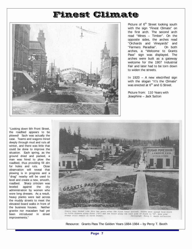
During the summer of 1910, the City, who owned steam roller and gravel wagons, prepared a macadamized roadbed for South Sixth Street. The east side of Sixth is viewed between I and J Street. The building at the right is the Rogue River Courier. Photograph part of the Percy T. Booth Collection
In 1909, this 17 ton monster was used to replace teams and wagons hauling lumber over primitive country roads to Grants Pass. Damage to bridges and culverts flamed a bitter feud between farmers and lumbermen. Photograph part of the Percy T. Booth Collection

Page 9
Can you imagine having to take a ferry across the Rogue River every time you had to cross it? This ferry at the left was Griffin Ferry and known as Upper Ferry. Other ferry operations were located near Robertson Bridge, Indian Mary Parks, Savage Rapids Dam, Rogue River, Applegate River and other areas. One of the earliest ferries was the Vannoy Ferry located on Lower River Road. The fees for using the Vannoy Ferry in the 1850’s were:
Unloaded wagon $1.00 Loaded wagon $1.50 Yoke of oxen .25¢ One sheep or hog .15¢ Unloaded animal .12¢ Foot passenger .12¢
THANK GOODNESS FOR BRIDGES
Bridges built: 1859 – Toll bridge built across the Illinois River at the ranch of John W. Patrick 1866 – First bridge built across Jones Creek 1886 – First county bridge built across Rogue River at Grants Pass is constructed at the cost of $7,000.00 and was washed out four years later by the 1890 flood 1886 – The first county bridge built across the Applegate, near the mouth of South Creek, cost $3,310.00 1882 - Contract for constructing the first county bridge across east fork of the Illinois was let at $1,400 1912 - Steel bridge built across Applegate at Murphy 1931 – Caveman bridge completed 1959 – Seventh Street Bridge built
Bridge across Applegate River near Murphy
Page 10
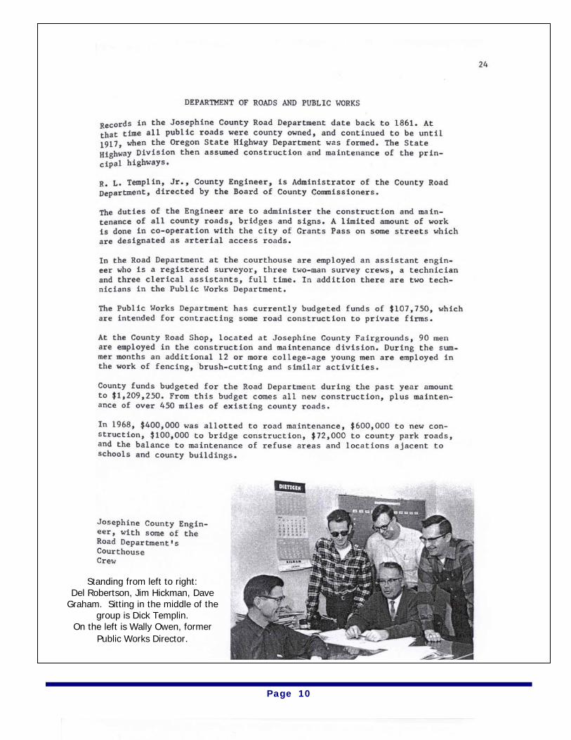
Standing from left to right: Del Robertson, Jim Hickman, Dave
Graham. Sitting in the middle of the group is Dick Templin.
On the left is Wally Owen, former Public Works Director.
Page 11
Interviewees
Page 12
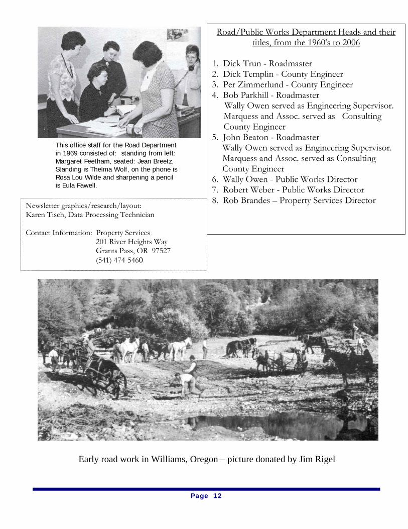
This office staff for the Road Department in 1969 consisted of: standing from left: Margaret Feetham, seated: Jean Breetz, Standing is Thelma Wolf, on the phone is Rosa Lou Wilde and sharpening a pencil is Eula Fawell.
Road/Public Works Department Heads and their titles, from the 1960's to 2006
1. Dick Trun - Roadmaster 2. Dick Templin - County Engineer 3. Per Zimmerlund - County Engineer 4. Bob Parkhill - Roadmaster
Wally Owen served as Engineering Supervisor. Marquess and Assoc. served as Consulting County Engineer 5. John Beaton - Roadmaster
Wally Owen served as Engineering Supervisor. Marquess and Assoc. served as Consulting County Engineer
6. Wally Owen - Public Works Director 7. Robert Weber - Public Works Director 8. Rob Brandes – Property Services Director Newsletter graphics/research/layout:
Karen Tisch, Data Processing Technician Contact Information: Property Services 201 River Heights Way Grants Pass, OR 97527 (541) 474-5460
Early road work in Williams, Oregon – picture donated by Jim Rigel