Embed Size (px)
Citation preview

Cowes and East Cowes
Flood Investigation Report
i
Flood Investigation Report
Document Information
Document Information
Document Reference 2013-IWC-LLFA-030-14
Document Revision
Report Status FINAL
Date 24 June 2014
Author W Perera
Checked
Approved B Murphy
Isle of Wight Council Planning & Regulatory Services Seaclose Park, Fairlee Road Newport, IW PO30 2QS Tel: 01983 832552 No part of this document may be copied or reproduced by any means without prior written permission from IWC. Any advice, opinions or recommendations within this document; a) should be read and relied upon only in the context of this document as a whole, b) do not in any way purport to include any manner of legal advice or opinion, c) are based on the information made available to IWC at the date of this document and on current UK standards, codes, technology and construction practises as at the date of this document. No liability is accepted for any use of this document other than for the purpose for which it was originally prepared and provided. The Isle of Wight Council cannot accept responsibility for any use or reliance on the contents from this report by any third party. Maps are reproduced from Ordnance Survey material with the permission of Ordnance Survey on behalf of the Controller of Her Majesty’s Stationery Office © Crown Copyright. Unauthorised reproduction infringes Crown Copyright and may lead to prosecution or civil proceedings.
ii
Contents Contents .................................................................................................................................................. ii
Executive Summary ................................................................................................................................. 1
Introduction ............................................................................................................................................ 2
Requirement for Investigations .......................................................................................................... 2
Site location and description .................................................................................................................. 2
Incidents triggering investigation ........................................................................................................... 3
History of flooding .................................................................................................................................. 4
Roles and responsibilities ....................................................................................................................... 6
Actions carried out following flooding .................................................................................................... 7
Recommendations and Future Actions................................................................................................... 7
Figure 1: Affected properties, Cowes and East Cowes .......................................................................... 3
Figure 2: EA Flood Map for Cowes and East Cowes ............................................................................... 4
Figure 3: Wave overtopping ................................................................................................................... 4
Table 1: Indicative costs of actions included within the Cowes/East Cowes Flood Investigation Report
................................................................................................................................................................ 8

1
Executive Summary This Flood Investigation Report has been compiled by the Isle of Wight Council as Lead Local Flood Authority (LLFA). As LLFA it has a duty to investigate significant flood events as defined under the Flood and Water Management Act 2010. Upon becoming aware of a flooding event within the Isle of Wight Council will consider whether an investigation should be carried out under the requirements of Section 19, Part 3 of the Flood and Water Management Act 2010. This investigation will determine which risk management authorities have a responsibility for managing flooding at the identified flood site and will ensure that there is an appropriate response to the flood incident. It was deemed necessary to undertake an investigation into the flooding incidents in the Cowes and East Cowes area due to the number of incidents, properties being affected and the need for direct intervention from IWFRS. This report provides a summary of the extent and consequences of the flooding and actions undertaken or proposed by each of the identified authorities with a responsibility for flooding within the identified area. This includes information relating to options for improvement works or general maintenance carried out at n the area. Whilst this report has sought to identify causes of flooding within the Cowes and East Cowes area and has made recommendations as to how the risk and / or impact of flooding may be reduced, this does not provide the Isle of Wight Council with the mandate or funding to implement any measures to reduce or remove the risk of flooding at this site.

2
Introduction
Requirement for Investigations
The Isle of Wight Council, within their role as Lead Local Flood Authority, have a responsibility to record and report flood incidents, as detailed in Section 19 of Part 3 of the Flood and Water Management Act 2010.
Part 1 FLOOD AND COASTAL EROSION RISK MANAGEMENT
3. Supplemental powers and duties Section 19: Local authorities: Investigations 1) On becoming aware of a flood in its area, a lead local flood authority must, to the extent that it considers it necessary or appropriate, investigate – (a) which risk management authorities have relevant flood risk management functions, and (b) whether each of those risk management authorities has exercised, or is proposing to exercise, those functions in response to a flood. 2) Where an authority carried out an investigation under subsection 1) it must – (a) publish the results of its investigations; and (b) notify and relevant risk management authorities
This report investigates the flooding incident in the Cowes and East Cowes area as the impacts to people; property and infrastructure were deemed to trigger the need for an investigation. This report aims to provide details of the flooding incident that occurred with a review of the roles and responsibilities of all risk management authorities having a responsibility for flooding at the identified site. It will also include an overview of any works undertaken or options proposed at the site in order to reduce the risk of flooding at the identified site.
Site location and description Cowes and East Cowes are located on the north coast of the Island. Both areas are urban in form with a mix of residential and commercial properties and both act as key gateways to the Island. Both Cowes and East Cowes are Key Regeneration Areas and are both geographically close and connected in terms of flood risk by the Medina Estuary and the North Solent coastline. While they are hydraulically independent of each other they share very similar characteristics. Both are situated on high ground which slopes down to the sea or estuary and neither settlement has significant upslope contributing catchments. Cowes is located on the western side of the Medina Estuary and represents one of the main transport connections to the mainland via high speed passenger ferry services to and from Southampton. Cowes waterfront is characterised by detached and semi-detached properties and a number of maritime related services and supply businesses. Behind the waterfront Cowes High Street contains a range of buildings, predominantly two storey which are used for a range of retail and commercial uses, with some second storey residential use. The waterfront of East Cowes has a greater prevalence of industrial activity while also possessing a strategic cross solent link in the form of a car ferry service between East Cowes and Southampton.

3
There exists a belt of land either side of the estuary which is relatively flat and this area is currently within flood zones. Beyond this coastal belt the land quickly rises in elevation.
The nature of flooding in these areas is significantly influenced by the configuration of local surface water drainage network and the relationship between drainage outfalls and tide levels.
Incidents triggering investigation Data on flooding indicates both Cowes and East Cowes experienced flooding incidents. The
incidents ranged from individual properties being affected through to a number of properties
experiencing direct and indirect flooding as a result of extreme weather events and high tides over
the period 14/02/14-15/02/14.
Figure 1: Affected properties, Cowes and East Cowes
4
In late December and early January there were incidents of individual properties experiencing
flooding, however the most significant events occurred in early January in East Cowes, with multiple
properties in Castle Street requiring intervention from IWFRS who pumped water out from
properties and in February in Cowes where circa 500m of the High Street flooded and required
intervention from IWFRS. A total of circa 104 commercial properties in Cowes were affected and 14
commercial properties in East Cowes.
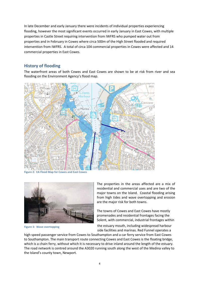
History of flooding The waterfront areas of both Cowes and East Cowes are shown to be at risk from river and sea flooding on the Environment Agency’s flood map.
Figure 2: EA Flood Map for Cowes and East Cowes
The properties in the areas affected are a mix of residential and commercial uses and are two of the major towns on the Island. Coastal flooding arising from high tides and wave overtopping and erosion are the major risk for both towns. The towns of Cowes and East Cowes have mostly promenades and residential frontages facing the Solent, with commercial, industrial frontages within
the estuary mouth, including widespread harbour side facilities and marinas. Red Funnel operates a
high speed passenger service from Cowes to Southampton and a car ferry service from East Cowes to Southampton. The main transport route connecting Cowes and East Cowes is the floating bridge, which is a chain ferry, without which it is necessary to drive inland around the length of the estuary. The road network is centred around the A3020 running south along the west of the Medina valley to the Island’s county town, Newport.
Figure 3: Wave overtopping

5
The coastal frontage and estuary consists of residential, commercial and port land uses. The area is of great economic importance to the Island supporting the marine service industry, two cross-Solent ferry ports, recreational sailing, major yachting events, some commercial fishing and the main industrial/commercial shipping port. Defences extend from Gurnard eastwards to Cowes and the mouth of the Medina Estuary. This defence line is primarily an ad-hoc series of both private and Environment Agency seawalls and provides only a moderate standard of protection (1 in 25). During periods of high spring tide/swell, areas of seawall backed by wide roads and parades are locally overtopped causing flooding. Active slope movement behind Egypt Esplanade periodically causes movement of the defences. A shingle ridge fronting Queens Road provides toe weight to the active coastal slope. The recently constructed Royal Yacht Squadron Jubilee Haven has improved the protection of The Parade from westerly storms. From the Parade to Cowes floating bridge consists of ad-hoc defence, mainly private, leisure and industrial marine infrastructure. The coastline from Cowes floating bridge to Medina Wharf is defended and fronted by sailing and industrial marine facilities and commercial wharf. Moving into East Cowes, the north east side of the Medina Estuary from Kingston Wharf to the north consists of private, leisure, and industrial related defences and infrastructure. At the eastern shore of the estuary mouth, from the Cowes floating bridge to the Shrape Breakwater consists of private defended frontages and slipways including the car ferry terminal, then public defences with a seawall and number of concrete groynes between Venture Quays and Old Castle Point. SEEDA (now HCA) recently improved the commercial facilities of Venture Quays by installing steel sheet piling and rock armour revetment. East Cowes suffers from localised flooding during periods of high spring tides/swell. The recently permitted outer breakwater and additional marina facilities have commenced, commissioned by the Cowes Harbour Commissioner (CHC). Works are being undertaken in 2 phases, one this summer, and completion after a period of settling. The breakwater is likely to provide for some benefit to flood risk as it could act to reduce wave action and create a sheltered environment making the immediate foreshore less susceptible to flooding in adverse weather conditions. The Isle of Wight Catchment Flood Management Plan identifies this area as Sub Area 3: Lower River Medina and Gurnard Luck. The issues in this sub-area are identified as: The River Medina and Gurnard Luck can flood from a number of causes. Both rivers are responsive to rainfall and both are affected by tide locking. Potential flood levels at Newport and Gurnard are particularly sensitive to future sea level rise due to a number of low lying properties. The scale of flood risk in this subarea is such that estimated property damages are relatively high in comparison to other parts of the catchment because of the significant population in the catchment. The relatively high number of properties at risk means that flood risk management activities are employed and existing defences which protect Newport and Gurnard need to be maintained. The IW Shoreline Management Plan sets the policy approach to coastal defence in the area. The intention of shoreline management for the area is to recognise and support the intrinsic nature of the waterfront location essential to a successful and sustainable future for Cowes and East Cowes. The management approach recommends the maintenance and raising of the standard of the current public and private defences lining the majority of the Gurnard, Cowes and East Cowes seafronts to address flood, erosion and landslide risks to these significant communities. This will also maintain the navigable channel of the Medina Estuary, supporting use of the Estuary waterfront within this area and also in the management unit to the south (MAN1B). It is recognised however that raising the level of existing private flood defences may be difficult to achieve in the centre and south of Cowes and East Cowes in a way which preserves or enhances the character of the area and the

6
nature conservation interest of the Medina, whilst maintaining waterfront access. The scale of the assets at risk (including residential and amenity development, marine industries and commercial wharfs) and their importance to the local and Isle of Wight economies justifies further examination and the development of a detailed approach through a Coastal Defence Strategy Study. Whilst the specific shoreline management approach may vary for localised areas of defence (e.g. defences immediately adjacent to current defences, or opportunities linked to developments), the intention would be in-keeping an overall management approach of holding the defence line of the wider area. It is important to note that this management intent should not preclude consideration of medium to long term adaptation of the town centres and communities; adaptation should be encouraged as risks will continue to increase as sea level rises and storm events occur. During the most recent extreme weather events, high winds and high tides led to over-topping and wave action and tidal action impacting upon the effectiveness and reliability of the non-return flaps on the seawall outfalls. This, combined with localised surface water run-off resulted in property and highway flooding.
Roles and responsibilities
The IW Council is responsible for highway drainage, which is managed for council by Island Roads under the Isle of Wight Highways PFI Contract. In addition, under the Emergency and Reactive Response section of the PFI contract Island Roads provide 24/7 emergency assistance in accordance with their Flood Management Plan. In addition, where the council is also landowner, the council has riparian landowner rights to maintain flows of water through watercourses (which includes ditches).
The Isle of Wight is the coastal protection authority with responsibility for coastal defence policy, through the Shoreline Management Plan and the council is in addition able to bid for monies for coastal related projects through its role and member involvement in the Southern Regional Flood and Coastal Committee (SRFCC). This is known as the Flood Defence Grant in Aid (FDGiA) budget.
The Local Planning Authority (LPA) has a statutory duty to consult with the EA and Southern Water in the development control process (on certain types of application and/or scales of development). Good working practices have been established with both agencies, and local policy included within the Island Plan Core Strategy to address issues of flood risk in development proposals that are located in known flood risk areas. Development proposals have to either specify finished floor levels within new development and/or provide evidence that only certain non-life critical activities are being proposed within flood risk areas. In terms of development within East Cowes in particularly for example a finished floor level approach was used for Waitrose and there is no evidence before the council that this particular property was affected by flooding during the winter 2013/14 storm events.
Island Roads are responsible for a defined Project Network which is made up of assets such as public roads, footways, verges, gullies, street furniture etc.
Island Roads manage the strategic sandbag collection points and in liaison with the council the availability of sandbags for general use across the Island.
The Environment Agency is responsible for main river and coastal related matters. The EA administer the national FDGiA and undertake assessment of projects submitted for funding through this funding resource.
Southern Water Services are responsible for foul drainage and operate the local pumping station in East Cowes.
Residents are riparian landowners. Where an individual owns land that has a watercourse running through it or land that adjoins a watercourse it is the responsibility of that

7
landowner to maintain the flow of water through the watercourse. In addition where riparian landowners are affected by main rivers they can undertake works to keep water flow clear, with permission from the EA.
Actions carried out following flooding The council has been administering the recently released adverse weather grants, and business rate
and council tax relief to properties impacted directly from flooding.
Sandbags were available from Well Road East Cowes and St Marys Car Park Cowes, but were limited
to use to protect access points into residential properties and local residents were asked to restrict
use to a maximum of 6 per property to ensure that the supply of sandbags could be used by as many
local residents as possible. During the event in February the IWFRS attended and pumped out
properties and were also deployed to construct sandbag defences.
Southern water storm pumps were operating during the February events. This means that incoming flows were greater than the capacity of the pumps that pump to Sandown and thus stormwater was discharged to the environment to protect homes from flooding. There is a 100-200m sea outfall at the local site. The capacities of Southern Water pumping stations are designed around Environment Agency consents and during storm events, incoming flows will be greater than the pumps ability to pump the water away. At this point the CSO will operate and discharge to the environment to prevent customers flooding. Discharges are regulated by the EA and Southern Water. Southern Water has several pumping stations around Cowes that pump into the Sea Clean Wight transfer. Many of these are critical including, St Mary's, Egypt Point, Springhill and High St. Island Roads have a scheme to replace ACO channels in the last quarter of 2014/15 which will help with medium storm events.
Recommendations and Future Actions
1. Review flood risk planning policy through the medina valley area action plan and ensure that
through the development control process all development proposals within Cowes and East
Cowes continue to conform with Policy DM14 (Flood Risk). This policy approach is also due
to be supplemented by a further supplementary planning document (SPD) relating in
particular to coastal communities and risk.
2. Commence work on the West Wight Coastal Erosion and Flood Risk Strategy that will enable
to policy approach in the Shoreline Management Plan to be implemented. A Coastal
Strategy for the West Wight coastline is being developed by the risk management
authorities (IWC and EA) from 2014 to 2016, for the coastline from Freshwater Bay to East
Cowes. This Strategy builds on the work of the approved Isle of Wight Shoreline
Management Plan (SMP) in defining coastal flooding and erosion risks to people and the
developed, historic and natural environments and identifying the preferred technically,
economically and environmentally sound and sustainable strategic options for managing
those risks over 100 years. It will examine the consequences of implementing the preferred
policies from the SMP and develop an implementation plan. Issues for consideration in the
West Wight Coastal Strategy include coastal flood risk to the towns of Yarmouth, Cowes and

8
East Cowes. The national ‘Partnership Funding’ system has been brought in since the
completion of the Isle of Wight Shoreline Management Plan and future coastal defence
schemes are likely to involve seeking a combination of public and private contributions. If
acceptable and affordable solutions cannot be found on some of these complex frontages,
there is the risk of significant damage, anxiety and loss of assets, and adaptation will be
required at various scales and timescales, including from individuals and the relevant
authorities. Risks should be reduced where possible and appropriate. Adaptation should be
encouraged in all circumstances, where the communities are facing increasing risks.
3. The Council, in liaise with Island Roads should review the location of sandbag collection
points across the Island.
4. The IW Council should continue to liaise with local town and parish councils to ensure that
the role and responsibilities of riparian owners are fully understood.
5. Island Roads to deliver the ACO works in 2014/15
Table 1: Indicative costs of actions included within the Cowes/East Cowes Flood Investigation Report
Action Number Indicative cost Budget/funding
2. WW Strategy year 1 £100k FDGiA approved
2. WW strategy Year 2 £70k FDGiA bid
5. Island Roads ACO work £tbc PFI Contract