Embed Size (px)
Citation preview

COMPLYING WITH THE NATIONAL POLLUTANT DISCHARGE ELIMINATION SYSTEM PHASE II STORM WATER REGULATIONS: NAVAL STATION NEWPORT STORM DRAIN OUTFALL MAPPING
NEWPORT, RHODE ISLAND
Laura M. Ernst, ESS Group, Inc. Cornelia A. Mueller, Naval Station Newport, Environmental Protection
Department Karen M. Hanecak, ESS Group, Inc. Gregory A. Rowe, ESS Group, Inc.
Abstract The United States Environmental Protection Agency (USEPA) has determined that municipal separate storm sewer systems (MS4s) are a major pathway for the introduction of pollutants to waterways and are a leading cause of the impairment of ambient water quality, for both fresh and coastal waters. The USEPA has developed regulations governing storm water for MS4s in 40 CFR Part 122. The Rhode Island Department of Environmental Management (RIDEM) has written equivalent regulations in its Regulations for the Rhode Island Pollutant Discharge Elimination System. MS4s are required to develop, submit for RIDEM approval, and ultimately implement a Storm Water Management Plan (SWMPP) that addresses six minimum control measures. ESS Group Inc. performed storm drain outfall mapping for the Naval Station Newport to comply with the Naval Station’s Phase II SWMPP Illicit Discharge Detection and Elimination program. ESS personnel used a handheld Global Positioning System unit with 3 ft. accuracy to obtain coordinates for outfalls to Narragansett Bay. With the coordinate locations, ESS then developed a Geographic Information System (GIS) map that includes the storm drain outfalls overlaid on geographic referenced orthophotographs. An interactive ArcView database was created as part of the GIS project which includes details on storm drain outfall, including type and size of pipe, presence/absence of flow, and date of inspection. The database will allow Naval Station Newport to easily track the condition and maintenance of storm water structures, record and track illicit discharges, record sampling data and identify trends and changes in water quality over time.
Introduction Naval Station Newport (NAVSTANPT) is located along the east passage of Narragansett Bay within the Towns of Portsmouth and Middletown and the City of Newport, Rhode Island (Figure 1). The Navy currently occupies approximately 1,565 acres of land distributed between the City of Newport (365 acres), the Town of Middletown (640 acres) and the Town of Portsmouth (555

acres). The property ranges in elevation from sea level (0.0 feet) to 170 feet near the Melville section of Portsmouth. Land topography and surface runoff throughout the property generally flows in a westerly direction towards Narragansett Bay. NAVSTANPT completed storm water outfall mapping to comply with the requirements of the Naval Station’s Phase II Storm Water Management Program Plan (SWMPP) Illicit Discharge Detection and Elimination program. The SWMPP was developed as a result of the Rhode Island Pollutant Discharge Elimination System (RIPDES), Phase II storm water regulations (Rule 31). The SWMPP addresses each minimum measure required by the RIPDES regulations, including the following: • Public Education and Outreach on Storm Water Impacts • Public Participation and Involvement • Illicit Discharge Detection and Elimination • Construction Site Storm Water Runoff Control • Post-Construction Storm Water Management • Pollution Prevention and Good Housekeeping for Municipal Operations. As part of the Illicit Discharge Detection and Elimination program, NAVSTANPT proposed to verify storm water outfalls within the first two years of the permit term. NAVSTANPT property storm water conveyance systems generally consist of drain piping, catch basins, drain inlets, grassed swales, and outfalls. There are an estimated 153 outfalls on NAVSTANPT and leased properties in eight drainage areas. In 2002, NAVSTANPT hired a consultant to create CADD drawings of these eight areas. In order to develop a maintainable database and mapping format, NAVSTANPT proposed to verify and map the outfall locations using a Global Positioning System as part of the Illicit Discharge Detection and Elimination program.
Methods ESS Group, Inc. (ESS) reviewed the areas to be mapped with the NAVSTANPT Environmental Protection Department. The general mapping area consisted of Gate 32 and south to include Coaster’s Harbor Island, and the area of shoreline along the mainland near the Naval Hospital in Newport Harbor (Figure 1). ESS located the outfalls by a Trimble Pro-XR Global Positioning System (GPS) unit that is accurate to within 3 feet. Identification and GPS mapping of the outfalls was done roughly two hours before and after low tide for a total of four hours. Field work was scheduled around low tide so that outfalls would be visible, and easily accessible. Detailed field observations were made, including

size and type of outfall (metal, concrete, PVC), presence of flow, submerged pipes, and state of the outfall, if damaged.
Results ESS developed an outfall GIS project based on the storm drain outfalls obtained with the Trimble Pro-XR GPS unit. The outfalls were numbered from 1 to 123 beginning at Gate 32. The coordinate system for the project was based on data obtained from the state-run Rhode Island Geographic Information System (RIGIS) - NAD83, State Plane (RI), ft. ESS used 1997 black and white 1:5000 ortho-rectified MrSID images from RIGIS to illustrate the location of the outfalls. The ArcView project also contains an interactive outfall database containing details on the storm drain outfalls, including the size and type of outfall (metal, concrete, PVC), presence of flow, submerged pipes, and state of the outfall if damaged. Photographs were taken for a few selected areas and are accessible by using the hotlink feature of ArcView. ESS also created a metadata file describing the data quality, project description, time period, spatial reference, and points of contact for the outfall features. The ArcView database will allow NAVSTANPT to easily add new information as it becomes available, including tracking the condition and maintenance of storm water structures, recording and tracking illicit discharges, and recording improvements and other related information
Conclusions Mapping storm water outfalls using a GPS unit is an effective tool for obtaining specific geographic locations and data that can be easily transferred to a trackable GIS database. This approach allows the MS4 to comply with the new USEPA regulations governing storm water and illicit discharges.
References Rhode Island Department of Environmental Management. 2002. Regulations
For The Rhode Island Pollutant Discharge Elimination System. Rhode Island Department of Environmental Management. December 18, 2003.
General Permit Rhode Island Pollutant Discharge Elimination System Storm Water Discharge from Small Municipal Separate Storm Sewer Systems and from Industrial Activity at Eligible Facilities Operated by Regulated Small MS4s.
Laura M. Ernst 401 Wampanoag Trail, Suite 400 East Providence, Rhode Island 02915 Phone: 401-330-1208; Fax: 401-434-8158 Email: [email protected]

Gate 32
Coasters Harbor Island

SOUTH COAST HABITAT RESTORATION PROJECT: MEASURING RESTORATION ON A LARGE SCALE
Megan Higgins, Rhode Island Coastal Resources Management Council Janet Freedman, Rhode Island Coastal Resources Management Council
The Rhode Island Coastal Resources Management Council and the Army Corps of Engineers have been working on the Rhode Island South Coast Habitat Restoration Project in order to begin restoration in Ninigret Pond, phase one of the project. The project, the largest habitat restoration project in New England, will ultimately restore 57 acres of eelgrass habitat in Ninigret, Quonochontaug and Winnapaug Ponds. Restoration is being phased in, with the initial construction at Ninigret and Cross Mills Ponds in fall 2004. Restoration will take place at Quonochontaug and Winnapaug Ponds in subsequent years. Eelgrass restoration is a high priority for coastal management programs. Eelgrass is submerged aquatic vegetation as defined by the Clean Water Act and therefore is classified as a Special Aquatic Site under Section 404 Guidelines of the Act. Over ninety percent of the historical eelgrass resources throughout Narragansett Bay and the salt ponds have been lost to dredging and poor water quality impacts in the last century. The restored eelgrass beds will serve as nursery areas for many recreational and commercial fisheries species, including bay scallop and winter flounder. Eelgrass habitat is being buried under a rapidly advancing flood tidal delta in Ninigret and Quonochontaug Ponds. Sand that is diverted into the coastal lagoons is lost from the littoral system. As a result, the sediment starvation to the ocean beaches is amplified. Researchers from the University of Rhode Island and University of New Hampshire have measured the extent of delta accretion, the loss of coastal beach, and have modeled parameters for eelgrass growth for the best restoration methods. A second component of the project will restore fish passage to Cross Mills Pond in Charlestown, creating 20 acres of anadromous fish spawning habitat. The new eelgrass beds and spawning habitat will promote the return of greater numbers of valued fish and shellfish than have been seen in recent years. They, in turn, will generate more robust fisheries and healthier salt ponds along the Rhode Island south shore. Fish passage will be restored to Cross Mills Pond by constructing a more direct route into the pond. This will allow for the migration of anadromous fish between Ninigret Pond (saltwater) and the Cross Mills pond and its tributaries (freshwater) to ensure reproduction of the species. The existing culvert is routed under Post Road and around a block of buildings. The fish cannot negotiate the existing culvert because it is too long. Due to its length, there is a significant lack of light, which also contributes to the inability of fish to migrate upstream.

The restoration of the eelgrass beds in the coastal ponds will require dredging the subtidal portion of the flood tidal deltas and creating sediment basins within the pond inlets. Since the establishment of permanent breachways to the ponds in the 1950s, sand accumulation on the flood tidal deltas has accelerated, burying the thriving eelgrass beds in Ninigret and Quonochontaug Ponds and shoaling Winnapaug Pond to a depth that is too shallow for eelgrass growth. Sediment basins will be excavated in the breachway inlets to capture sand before it enters the ponds. This will ensure that the restored eelgrass beds are not reburied. The state will maintain the sediment basins by periodically dredging them. Some of the sand from the dredged areas will placed on or just offshore the nearby beaches. Some sand will go to dewatering sites where, after drying, it can be transported to the beaches that are most vulnerable to coastal erosion. Megan Higgins RI Coastal Resources Management Council Stedman Government Center 4808 Tower Hill Road Wakefield, RI 02879 (p) 401-783-3370 (f) 401-783-3767 [email protected]

MASSACHUSETTS’ BENTHIC HABITAT MAPPING
PLAN: DETAILS ON MAP DEVELOPMENT
Megan Tyrrell, Massachusetts Coastal Zone Management
Abstract
In an effort to improve marine habitat management, Massachusetts Coastal Zone Management is forming a comprehensive marine habitat management plan. The twelve major sections of the plan are briefly highlighted. One component that has already been written is the strategic plan to obtain benthic habitat maps for all Commonwealth waters. These benthic habitat maps will be instrumental in informing future resource management decisions, especially project siting. An overview of the mapping survey design will be presented, including the groundtruth sampling scheme, the parameters assessed and the methods to delineate the polygons of various habitat types. The rationale behind the sampling design, including implications of other sampling schemes, will be discussed. These groundtruth survey and habitat delineation methods, if successful, could serve as a prototype for other broad scale habitat mapping initiatives.

MARINE RESOURCE MANAGEMENT OF THE OSA PENINSULA AND GOLFO DULCE, COSTA RICA
Ben Starkhouse, University of Washington
Abstract The Osa Peninsula and Golfo Dulce region of Costa Rica is a unique marine environment that hosts a diverse assortment of vertebrates, invertebrates, bivalves, corals and marine mammals. The region’s growing tourism industry, unmonitored marine species harvesting, and unsustainable land use practices are threatening the existence of several marine species and the overall health of the marine environment. As of today there are few laws and regulations in place regarding the coastal zone and open waters of the Osa Peninsula and Golfo Dulce. However, several governmental agencies, NGO’s, and concerned individuals are working to increase protection of the marine environment by creating and implementing marine resource management plans and projects. My research summarizes my summer 2003 internship for an NGO based in San Jose, Costa Rica and consists of an objective look into the current health of marine resources and existing conservation plans. I conclude with suggestions for future management strategies given the area’s social, economic, and environmental conditions.

THE DRAGON RUN: WATERSHED MANAGEMENT ACROSS JURISDICTIONAL BOUNDARIES
IN VIRGINIA’S MIDDLE PENINSULA
J. David Fuss, Middle Peninsula Planning District Commission
Introduction As one of the Chesapeake Bay watershed’s most pristine waterways, the Dragon Run “encompasses some of the most extensive and unspoiled swamp forest and woodland communities in Virginia” (Belden, Jr. et al. 2001). Effectively bisecting Virginia’s Middle Peninsula located between the York and Rappahannock Rivers (Figure 1), this fresh and brackish water stream meanders along and through nontidal and tidal cypress swamp. The watershed is mainly undeveloped, mostly privately owned, and covers approximately 140 square miles (90,000 acres) of rural landscape – mostly forests, farms, and wetlands. The spring-fed Dragon Run flows through portions of Essex, Gloucester, King and Queen, and Middlesex Counties, emptying into the estuarine Piankatank River and ultimately the Chesapeake Bay (Figure 1). This mysterious river plays a central role in the Middle Peninsula’s culture and identity. Natural resources – forestry and farming – have been the bedrock of the watershed’s economy. These land uses and its unique natural resources are the main reasons that the Dragon Run remains wild and secluded. The Dragon Run’s unique character evokes strong motivation to protect the pristine watershed in both long-time residents and first-time visitors alike. Although development pressure in the watershed is currently low, the potential for significant land ownership changes due to aging and absentee corporate landowners threatens to disrupt the rural character and fragment productive farm and forestland and natural habitat. Designed to proactively preserve the Dragon Run watershed’s traditional land uses and unique natural resources, the Dragon Run Special Area Management Program is a collaborative effort between the Middle Peninsula Planning District Commission’s Dragon Run Steering Committee and the Virginia Coastal Program at the Department of Environmental Quality.
Regional Cooperation With funding support from the National Oceanic and Atmospheric Administration through the Virginia Coastal Program at the Department of Environmental Quality, the Dragon Run Steering Committee has been a standing committee of the Middle Peninsula Planning District Commission since 1985. Virginia’s Planning District Commissions are designed to encourage cooperation and coordination when planning for state and local government
Figure 1. Location of the Dragon Run watershed in the Chesapeake Bay
issues of a regional nature. The Dragon Run Steering Committee aims to promote the orderly and efficient planning and management of the environmental, social, and economic resources within the Dragon Run Watershed. The Committee is truly community-based, since two-thirds of the four counties’ appointees are landowners. The “Dragon Run Watershed Management Plan” (MPPDC, 2003) is the Committee’s symbol of regional cooperation and coordination that crosses jurisdictional boundaries.

Watershed Management The Dragon Run Watershed Special Area Management Program (SAMP) is designed to address both the differing viewpoints and the common ground that exist concerning the future of the watershed. The project began in January 2002 as a partnership between the Dragon Run Steering Committee and the Virginia Coastal Program at the Department of Environmental Quality through a grant from the National Oceanic and Atmospheric Administration. The Steering Committee’s approach was to stimulate and coordinate community involvement in the proactive development and implementation of goals, objectives, and action plans for a watershed management plan. Beginning with public planning forums, the Steering Committee developed and confirmed common themes for watershed issues and established an Advisory Group representing a broad cross-section of the community. The Advisory Group consists of representatives from the Committee, local, state, and federal governments, landowners and citizens, business and industry, educators, and conservation organizations. Building upon this foundation, the Advisory Group produced a list of three goals, each with several objectives (Table 1). The Steering Committee approved the goals and objectives and incorporated them into a Memorandum of Agreement that was signed by all four of the counties and the Planning District Commission. Subsequently, the Steering Committee produced a list of recommended actions (Table 2) to achieve the goals and objectives incorporated into the “Dragon Run Watershed Management Plan” (2003). This comprehensive watershed management plan represents a body of work by citizens, stakeholders, and decision-makers to achieve a common vision for the future – the preservation of the traditional uses and unique resources in the Dragon Run (Figure 2). Plan implementation should include coordinated land use policies, programs that support forestry and farming, and managed public access. The momentum generated by this watershed management planning process has served to address coastal land use policies, sustainable economic development, watershed education, land conservation, public access, and invasive species control. Monitoring plan implementation will be a key component to assess success over time. Long-term funding has provided the stability necessary to carry out this time-consuming process that balances the differences of opinion on how to address the threat to the watershed and the common ground that defines the community’s vision for the future of the watershed.

Table 1. Goals and objectives of the Dragon Run Watershed Management Plan
Mission: To support and promote community-based efforts to preserve the cultural, historic, and natural character of the Dragon Run, while preserving property rights and the traditional uses within the watershed
Goal I: Establish a high level of cooperation and communication among the four watershed counties to achieve consistency across county boundaries
Objective A: Develop a plan to address the inevitable future development pressure to change the traditional use of land in the watershed Objective B: Achieve consistency across county boundaries among land use plans and regulations in order to maintain farming and forestry and to preserve natural heritage areas by protecting plants, animals, natural communities, and aquatic systems Objective C: Provide ongoing monitoring of existing plans and planning tools in order to assess traditional land uses and watershed health and take action necessary to preserve the watershed Objective D: Comprehensively implement Best Management Practices (BMPs) for water quality, wildlife habitat, and soil conservation
Goal II: Foster educational partnerships and opportunities to establish the community’s connection to and respect for the watershed’s land and water
Objective A: Encourage experience-based education consistent with the Stewardship and Community Engagement goals of the Chesapeake 2000 Agreement Objective B: Promote the community and economic benefits of the Dragon Run derived from its natural characteristics and traditional uses such as farming, forestry, hunting and fishing
Goal III: Promote the concept of landowner stewardship that has served to preserve the Dragon Run Watershed as a regional treasure
Objective A: Address the potential dilemma of preserving the watershed’s sense of peace and serenity by protecting open space and reducing fragmentation of farms, forests, and wildlife habitat versus the landowners’ rights in determining or influencing future land use Objective B: Teach landowners the watershed’s regional importance
Conclusions The “Dragon Run Watershed Management Plan” (2003) is a symbol of regional cooperation and coordination that crosses jurisdictional boundaries. It is the next logical step on the path towards protecting the Dragon Run watershed and preserving its cultural, historic, and natural heritage for future generations. It is neither a static document nor an end in and of itself. It is a citizen-initiated vision for the future of the watershed that may be modified as situations change or as new information becomes available. It is a vision that harnesses the passion and energy for the Dragon Run of those who live, work and play in its watershed.

Table 2. Recommended actions of the Dragon Run Watershed Management Plan
1. Land Use and Resource Preservation A. Designate a Unified “Dragon Run Planning Area” B. Implement Tools to Preserve Farm, Forest, and Natural Resources C. Address Public and Landowner Access Issues D. Control Invasive Species
2. Education and Landowner Stewardship 3. Encourage and Support Sustainable Economic Development 4. Monitor Plan Implementation
Figure 2. Watershed planning balances traditional uses and natural resources
References Belden, A. Jr., A.C. Chazal, G.P. Fleming, C.S. Hobson, and K.M. McCoy.
2001. A Natural Heritage Inventory of the Dragon Run Watershed. Second edition. Natural Heritage Technical Report 01-03. Virginia Department of Conservation and Recreation, Division of Natural Heritage, Richmond, VA. 64 pp. plus appendix.
Middle Peninsula Planning District Commission. 2003. Dragon Run Watershed Management Plan. Middle Peninsula Planning District Commission, Dragon Run Steering Committee, Saluda, VA. 69 pp. plus appendices.
J. David Fuss Director, Dragon Run Special Area Management Plan Middle Peninsula Planning District Commission P.O. Box 286 Saluda, VA 23149-0286 Phone: 804-758-2311, Ext. 25 Fax: 804-758-3221 Email: [email protected]
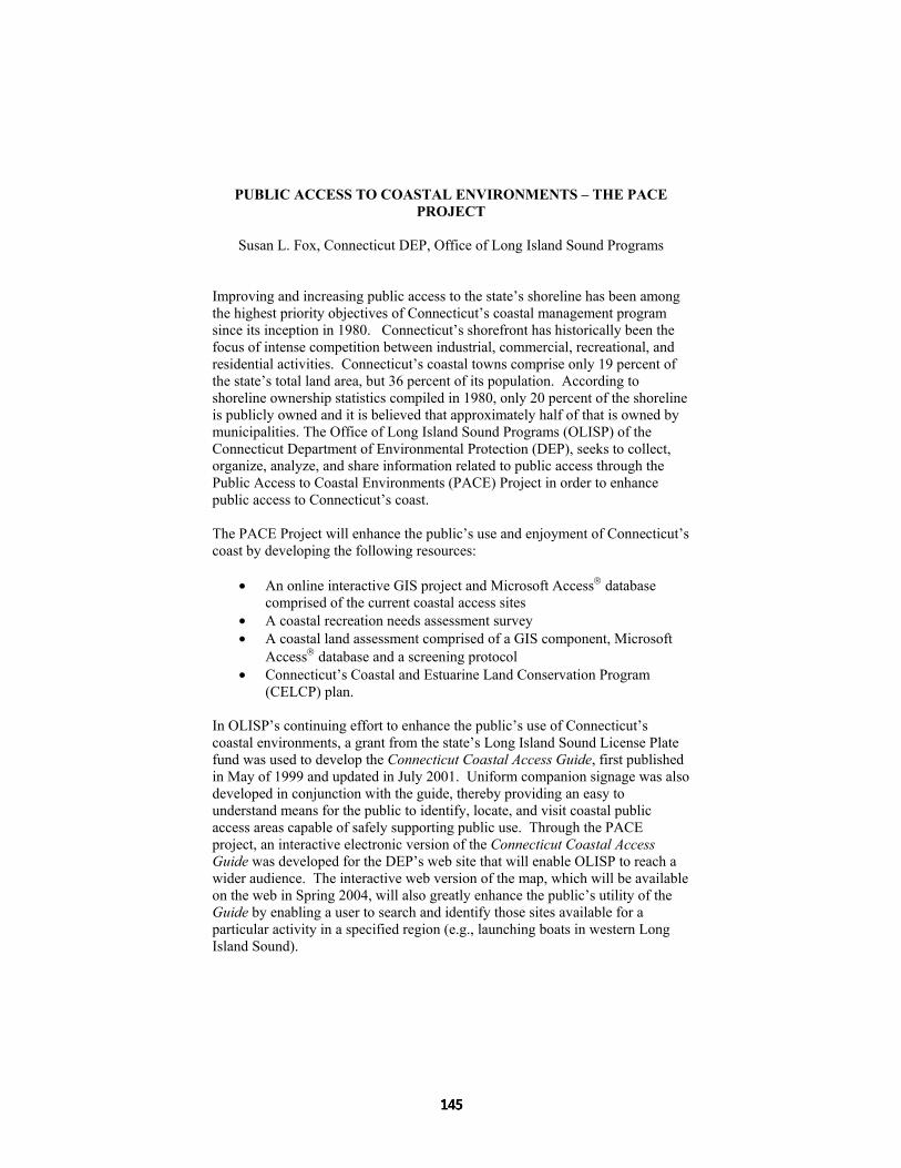
PUBLIC ACCESS TO COASTAL ENVIRONMENTS – THE PACE PROJECT
Susan L. Fox, Connecticut DEP, Office of Long Island Sound Programs
Improving and increasing public access to the state’s shoreline has been among the highest priority objectives of Connecticut’s coastal management program since its inception in 1980. Connecticut’s shorefront has historically been the focus of intense competition between industrial, commercial, recreational, and residential activities. Connecticut’s coastal towns comprise only 19 percent of the state’s total land area, but 36 percent of its population. According to shoreline ownership statistics compiled in 1980, only 20 percent of the shoreline is publicly owned and it is believed that approximately half of that is owned by municipalities. The Office of Long Island Sound Programs (OLISP) of the Connecticut Department of Environmental Protection (DEP), seeks to collect, organize, analyze, and share information related to public access through the Public Access to Coastal Environments (PACE) Project in order to enhance public access to Connecticut’s coast. The PACE Project will enhance the public’s use and enjoyment of Connecticut’s coast by developing the following resources:
• An online interactive GIS project and Microsoft Access database comprised of the current coastal access sites
• A coastal recreation needs assessment survey • A coastal land assessment comprised of a GIS component, Microsoft
Access database and a screening protocol • Connecticut’s Coastal and Estuarine Land Conservation Program
(CELCP) plan. In OLISP’s continuing effort to enhance the public’s use of Connecticut’s coastal environments, a grant from the state’s Long Island Sound License Plate fund was used to develop the Connecticut Coastal Access Guide, first published in May of 1999 and updated in July 2001. Uniform companion signage was also developed in conjunction with the guide, thereby providing an easy to understand means for the public to identify, locate, and visit coastal public access areas capable of safely supporting public use. Through the PACE project, an interactive electronic version of the Connecticut Coastal Access Guide was developed for the DEP’s web site that will enable OLISP to reach a wider audience. The interactive web version of the map, which will be available on the web in Spring 2004, will also greatly enhance the public’s utility of the Guide by enabling a user to search and identify those sites available for a particular activity in a specified region (e.g., launching boats in western Long Island Sound).

The comprehensive GIS project and Microsoft Access database comprised of the current coastal access sites includes multiple tables as well as custom designed forms with features to allow easy and accurate entry. The original information used for the paper guide was updated and refined for use on the interactive web guide. Each of the sites included in the Coastal Access database was inspected to determine, among other site characteristics, the principal types of recreational uses occurring at the site, and, in some instances, to obtain photographs. The Coastal Access website serves as a comprehensive source of public access site information to meet a variety of coastal recreation needs (e.g., fishing, boating, birding, etc.). It is possible to search for coastal access a variety of ways. One can search by site name, search by town, search by activity, or use a map to search for sites (see arrow on graphic below).
To better understand the public’s coastal recreation needs and to better assess demand for recreational use of Connecticut’s coast, a coastal recreation needs access survey has been developed and distributed. Three coastal access surveys are now available to determine demand for the following coastal recreation uses: (1) saltwater angling and waterfowl hunting survey; (2) wildlife observation survey; and (3) coastal boating survey. The Connecticut DEP intends to use the data obtained from the surveys to identify and prioritize coastal land acquisition opportunities or otherwise improve existing coastal recreation facilities. The Connecticut DEP announced the availability of the surveys on its website, on multiple recreation organization websites, with signage in the DEP boating license office and through outreach projects. The results from the survey will be entered into a GIS project and an Access database to help DEP-OLISP identify coastal properties capable of meeting the identified recreational needs.

Another resource created through the PACE project is a coastal land assessment of existing shoreline ownership in Connecticut. Specifically, this assessment is being completed to identify Connecticut’s remaining unprotected coastal areas with high coastal recreation value. This coastal land assessment is comprised of a GIS component, MS Access database and a screening protocol. The Office of Long Island Sound Programs is collaborating with DEP-Environmental Geographic Information Center and the University of Connecticut to gather and analyze GIS data for this project. Results from the coastal recreation needs survey and coastal land assessment will be used in developing Connecticut’s Coastal and Estuarine Land Conservation Program (CELCP) plan. Congress recently established the CELCP Plan to protect coastal and estuarine areas that have significant conservation, recreation, ecological, historical, or aesthetic values, or that are threatened by conversion from their natural or recreational state to other uses. In accordance with Federal Guidelines established to implement the CELCP, Connecticut is developing a CELCP Plan that will identify key conservation needs/values to be protected, coastal land acquisition priority areas, and a process through which Connecticut will select individual projects that would be submitted to NOAA for funding through CELCP. In preparing Connecticut’s CELCP plan, OLISP has also reviewed other state land protection strategies and contacted interested state, local, and nonprofit entities for help on identifying key coastal conservation needs, in addition to utilizing results from other components of the PACE project. The PACE Project has improved OLISP’s ability to provide new and enhance existing coastal access opportunities by improving the understanding of existing shoreline ownership, developing a mechanism for prioritizing coastal properties for public acquisition, increasing the public’s use of existing coastal access information through the interactive web guide, and filling critical data gaps regarding existing but underutilized public access sites. Susan L. Fox NOAA Coastal Management Fellow Connecticut Department of Environmental Protection Office of Long Island Sound Programs 79 Elm Street Hartford, CT 06106, USA Ph (860) 424-3034 Fax (860) 424-4054 [email protected]

ECOLOGICAL EVALUATION OF NEAR-SHORE SPOTS AS KEY TO LEGALIZE MARINE PROTECTED AREAS AT THE COASTLINE OF
AKLAN, PHILIPPINES
Kai – J. Kühlmann Consultant for Coastal Resource Management & Aquaculture
Abstract In the 11 coastal municipalities of the Province of Aklan, Philippines, near-shore spots to be legally established as marine protected areas (MPAs) have been assessed by manta tow and transect dives in 2003 to highlight approaches to local stakeholders dealing with the socio-ecological conflict of scarce food, degrading coastal environment and incessantly growing population in rural coastal areas. Surface composition, hard coral coverage and standing fish biomass were quantified at each spot to derive a ranking based on ecological conditions. Municipal ordinances involving specifically outlined management plans were drafted and discussed with local government units, municipal fisheries councils and local NGO’s during a province-wide planning workshop. At five spots, flat sand bottom but no corals reefs dominated, while at four spots fringing and patch reefs resulted in fair conditions with coral rocks and dead standing corals remarkably overgrown by algae. Two areas resulted in good and very good conditions with potential hard coral cover of massive and table-like growing forms. Municipal ordinances and MPA management plans, jointly drawn by involved stakeholders, contain artificial reef construction inside selected MPAs, locally suitable livelihood alternatives and CRM-related curricula for Aklan’s schools. These endeavors shall serve as basis to raise law enforcement, environmental awareness and income generating support.
Introduction Uncontrolled clearing of primary forests, pond-aquaculture development, and, the short-term profit-seeking of commercial fishing fleets operating near-shore degraded the once vast coastal environment of the Philippines and its aquatic resources in the 70’s and 80’s. These anthropogenic interventions, subsequently, caused terrestrial run-off and heavy siltation to the near-shore environment. The easy accessibility of coastal habitats led countless upland farmers to migrate to coastal areas, and thereby, created a sizable increase to the local coastal population and caused increasing fishing pressure, leading eventually to

destructive fishing methods, such as blast and cyanide fishing and the use of fine meshed nets. The omnipresent socio-ecological conflict caused by scarce food supply, degradation of the coastal environment and incessantly growing local population as well as increasing poverty, therefore, demands effective intervention. The establishment and continuous monitoring of a marine reserve, a delimited no-take area accepted by local stakeholders, is one of the approaches hypothesized to rehabilitate degraded reef areas that may contribute to the renewal of fish stocks through their migration to nearby areas after 5 years or longer of protection (Alcala 1988; Wantiez et al. 1997). The predicted “spill over effect” of fish stocks to nearby fishing grounds and the consequent increase in fish catch may then contribute to the improvement of the socio-economic welfare of the coastal population (Bolido and White 1997; Agbayani et al. 2000). From May to August 2003, 11 near-shore spots adjacent to 11 coastal municipalities along the 155 km long coastline of the Province of Aklan, Philippines, have been dive-evaluated prior to establish MPAs. The plan is to gain higher ecological benefit in coral diversity and abundance as well as standing coral reef fish biomass compared to the surrounding marine environment. Gathered information in this study was conducted through the extension work of the German Development Service (DED), which aimed to prepare the provincial government of Aklan in a joint effort with local stakeholders towards MPA management planning and legislation as well as towards locally suitable alternative livelihood development.
Methodology The 11 MPAs, ranging between 40 and 375 ha along the 155 km coastline of the Province of Aklan, Panay Island, Philippines (11°51’59” to 11°34’35” N; 122°35’00” to 125°52’34” E), were ecologically assessed from May to August 2003 by manta tow (English et al. 1994) and transect dives (based on McManus et al. 1997). The Province of Aklan totaled 451,314 inhabitants (2000) with 29,597 inhabitants (6.6 %) considered as coastal population, who are likely to be engaged in municipal fisheries (191 inh. km-1) (PPDO 2003). Using parameters easily applicable to field conditions, the MPA’s surface composition [sand/silt/rubble (S/S/R), rock (Ro), dead coral (DC), hard coral (HC), soft coral (SC)] was quantified (%) by manta tow and in more detail additionally into silt (Si), sand (Sa), rubble (Ru) and alga (Al) by transect dive to derive the MPA’s condition index (CI). Hard coral coverage (HCC) was measured at the 20 m transects to determine coral coverage index (CCI) and reef condition index (RCI) (Kühlmann 2002). Fish visual census was conducted by two divers gliding parallel to the transect line, counting and video-recording coral reef fish by size class (1 to 10 cm and 11 to 20 cm). Estimation of coral reef fish biomass for each taxonomic family (Acanthuridae, Caesionidae,

Chaetodontidae, Labridae, Lutjanidae, Nemipteridae, Pomacentridae, Scaridae, Serranidae) was based on the average body mass of the data published by Froese and Pauly (2000), Letourneur (1998), and Letourneur et al. (1998) and calculated using the length-weight relation formula (Ricker 1979). Average body masses of coral reef fish for each taxonomic family were then multiplied by the number of fish obtained at each transect in order to determine the fish’s biomass for a taxonomic family and to finally estimate the coral reef fish biomass for each MPA. In a two-day Aklan Fisheries Management Workshop, the results of the evaluated MPAs were presented to the about 60 workshop participants comprised of two to four municipal LGU-representatives as well as local NGO’s and the academe. Participants had to refine their municipal MPA management plans. Proposed livelihood alternatives were based on the environmental characteristics of the reserves and their surrounding areas, local anthropogenic influences, and its suitability for local stakeholders.
Results and Discussion Surface composition obtained by manta tow resulted in pure sand but no corals and fish at the MPAs of the Municipalities of Makato, Numancia, Kalibo, New Wahington and Altavas, therefore no further transect dives were conducted at these sites. Fringing reefs were found in Buruanga and Nabas, while patch reefs occurred in Malay, Ibajay, Tangalan and Batan. S/S/R above 50% was obtained at most patch reefs (Malay 56 %, Ibajay 65 % and Batan 63 %) and at the fringing reef in Nabas (71 %). At the fringing reef of Buruanga 29 % of S/S/R occurred with combined rock cover of 24 %, similarly as at the patch reef of Tangalan (45 % vs. 22 %). Hard coral cover was highest in Buruanga (45 %) followed by Malay (29 %; combined with soft corals of 14 %) and Tangalan (25 %). Soft corals and dead corals in all other areas remained in minority. Surface composition conducted by transect dives, carried out at selected high diversity spots of each surveyed area, revealed rocks overgrown by algae and associated with hard coral cover at the fringing reefs in Buruanga (37 % – 23 % – 34 %) and Nabas (30 % – 23 % – 32 %). The patch reef in Malay was composed of sand (14 %) and rubble (31 %) with hard coral cover of 28 %. In Ibajay, Tangalan and Batan, soft and hard coral associations of 18 % vs. 28 %, 26 % vs. 35 % and 10 % vs. 45 % occurred respectively on rocky (21 % Ibajay and 30 % Tangalan) or rubble (16 % Batan) areas. Although a high CI was determined for all fringing and patch reefs (range: 0.42 to 0.66), a high CCI, reflecting high hard coral coverage, was only obtained for Tangalan (0.39) and Batan (1.03) due to less alga coverage compared to the other MPAs (Table 1). Highest RCI of 0.52 and 0.81 were likewise determined for MPAs in Tangalan and Batan, resulting in good and very good coral reef conditions, respectively.

Standing coral reef fish biomass was highest in the fringing reefs of Buruanga (39.9 t km-2) and Nabas (20.1 t km-2) and at the patch reef MPA in Batan (23.9 t km-2). Lower fish biomass between 5.2 t km-2 to 6.6 t km-2 was estimated for the patch reefs of Malay, Ibajay and Tangalan. Remarkably high standing fish biomass was attained at the 9 year old concrete artificial reef (AR) in New Washington (282.9 t km-2) compared to the 14 year old rubber-tire AR in Kalibo (68.2 t km-2). Encouraged with this, further concrete-made AR’s have been deployed in Malay (jack-stone type) and Tangalan (52 bar-towers) inside core areas of the respective MPAs in 2003. During the Aklan Fisheries Management Workshop, seaweed and abalone farming turned out as suitable livelihoods in municipal waters of Buruanga and Nabas, while eco-tourism development is underway in the Municipalities of Tangalan and Batan. By convening for a seminar on fisheries law enforcement in mid 2004, the rampant practice of illegal fishing methods along the coastline— one of the major problems—shall be countered. Table 1: Ecological condition of assessed MPAs in the province of Aklan, Philippines
MPA CI1 CCI2 RCI3 RC4 1 0.61 0.17 0.39 fair 2 0.42 0.27 0.35 fair 3 0.65 0.28 0.46 fair 4 0.64 0.18 0.41 fair 5 0.66 0.39 0.52 good 6 0.59 1.03 0.81 very good
1 CI (Condition Index) = (Al + HC + SC) [%] / 100 [%] 2 CCI (Coral Coverage Index) = HCC (t1) [m] = HCC(t2) [m] / 40 [m] HCC = hard coral coverage 3 RCI (Reef Condition Index) = (CI + CCI) / 2 4 RC (Reef Condition) = 1.0 – 0.75 = very good, 0.74 – 0.5 = good, 0.49 – 0.25 = fair, 0.24 – 0 = poor (based on Gomez et al. 1994) 1 = Buruanga, 2 = Malay, 3 = Nabas, 4 = Ibajay, 5 = Tangalan, 6 = Batan, MPA = Marine Protected Area
Conclusions Evaluations of marine areas to be legalized as MPAs serve as a basis to awaken dialogue with local stakeholders regarding sustainable coastal management and provide an efficient means to determine an MPA’s ecological status under simple field conditions. For coastal municipalities of the Province of Aklan, an integrated network carried out under the provincial government and actively engaging coastal stakeholders shall contribute to increase coastal management awareness on CRM to further disseminate started projects to future generations.

References
Agbayani, R.F., D.B. Baticados and S.B. Siar, 2000. Community fishery
resources management on Malalison Island, Philippines: R & D Framework, Interventions, and Policy Implications. Coastal Management, 28: 19-27.
Alcala, A.C., 1988. Effects of Marine reserves on coral fish abundances and yields of Philippine coral reefs. AMBIO 17(3): 194-199.
Bolido, L. and A.T. White, 1997. Reclaiming the island reefs. People and the Planet, 6(2): 22-23.
English, S., C. Wilkinson and V. Baker, 1994. Survey Manual for tropical Marine Resources. Australian Institute of Marine Science, Australian International Development Assistance Bureau, Townsville, Australia.
Froese, R. and D. Pauly (eds.), 2000. FishBase 2000: concepts, design and data sources. ICLARM, Manila, Philippines.
Gomez, E.D., P.M. Alino, H.T. Yap and W.Y. Licuanan, 1994. A review of the status of Philippine reefs. Mar. Pollut. Bull., 29(1-3): 62-68.
Kühlmann, K.-J., 2002. Evaluations of marine reserves as basis to develop alternative livelihoods in coastal areas of the Philippines. Aquaculture International, 10: 527-549.
Letourneur, Y., 1998. Length-weight relationship of some marine fish species in Réunion Island, Indian Ocean. – NAGA, 21(4): 37-39.
Letourneur, Y., M. Kulbicki and P. Labrosse, 1998. Length-weight relationship of fishes from coral reefs and lagoons of New Caledonia – An update. NAGA, 21(4): 39-46.
McManus, J.W., M.C.A. Ablan, B.M. Vallejo, L.A.B. Meñez, K.P.K. Reyes, M.L.G. Gorospe and L. Halmarick, 1997. ReefBase aquanaut survey manual. ICLARM Contribution No. 1374, Manila, Philippines.
PPDO, 2003. Socio-economic profile, Province of Aklan 2001 – 2005. Provincial Planning & Development Office, Kalibo, Aklan, Philippines.
Ricker, W. E., 1979. Growth rate and models. In: Fish physiology – Bioenergetics and growth (eds. Hoar, W. S., D. J. Randall and J. R. Brett). Academic Press New York, San Francisco, London, Vol. 8, pp. 677-743.
Wantiez, L., P. Thollot and M. Kulbicki, 1997. Effects of marine reserves on coral reef fish communities from five islands in New Caledonia. Coral Reefs, 16: 215-224.
Dr. Kai-J. Kühlmann Consultant for CRM & Aquaculture, German Development Service (DED) Provincial Planning & Development Office (PPDO), Capitol Bldg. 5600 Kalibo, Aklan, Philippines Ph: +63(36)268-5442; Fax: +63(36)262-1555 e-mail: [email protected] or [email protected]
LUXURY ENVIRONMENTS AND SUSTAINABLE TOURISM: RESPONSIBLE SITING, DESIGN AND DEVELOPMENT OF
DESTINATION RESORTS IN THE COASTAL ZONE
Rebecca A. Ellis, School of Marine Affairs, University of Washington The 21st century faces new challenges in the relationship between travel and tourism, and sustainable development. The need to preserve the world’s inherent assets for future generations is imperative to sustaining the health of the planet. Tourism depends upon unspoiled, attractive destinations as economically sustainable products as well. Coastal tourism or hospitality products, such as destination resorts, directly impact natural and social environments in ways that promote instability in physical, biological and human dimensions. Building capacity for sustainably managing the resources and cultures associated with idyllic seaside images requires commitments from each component of the tourism model—brokers, locals and tourists. Concerted management efforts must realize multiple needs, causes and effects of resource-use uncovered by an intricate web of causality. To address only one issue may not effectively create positive change. Similarly, sustainable solutions to the production of tourism commodities, such as a coastal resort, involve a variety of institutions and persons that assist in its design, implementation and operation. For example, coastal environments, which often host destination resort development, have many complexities within natural, social, and political dimensions. Promotion of a sustainable future in recognition of today’s economic growth policies and continued consumptive development practices can be greatly shaped by the creators of the built environment in coastal regions. Sustainable design relies upon thorough planning, an integrated approach spanning disciplines and project phases, and a psyche of place-based or contextual development practice. As Vitruvius, the grandfather of architecture said in 110 B.C., “…we must at the outset take note of the countries and climates in which buildings are built.” An architect, or design professional, represents only one sector of the resort development process—a process that is driven by many concerns, objectives, timescales, and target markets. The role of the architect though, bound by its responsibilities and yet limitless with creative opportunity, is arguably the most potent for realizing sustainable design goals for hospitality design projects as an extension of ‘good’ or ‘responsible’ design practice. Sustainable design is not a new building style or series of criteria, but rather a holistic way of thinking about development that begins with a napkin sketch and continues through long-term operational practice. As the architect orchestrates much of the initial conceptual and built environment activity, he or she has the power to shape a

site and therefore a destination resort experience, representing social, economic, environmental and experiential sustainability. This study provides a guide to sustainable tourism development directed towards the architect and/or hospitality design professional. The destination resort project type represents a large-scale built environment that captures professional design input from Tourism Development Planners, Regional and Urban Planners, Site Planners and Landscape Architects, Architects, and Interior Architects as well as a variety of engineers, consultants, and clients. When the title of ‘architect’ appears within this study, it is meant to include any and all of these professionals as they impact a project’s design by manipulating existing spatial and experiential environments with built consequences. As a study tool, a resort hotel “…is itself often a destination and by its nature must fit into and reflect its surroundings. A successful resort conveys a strong and prominent sense of place and celebrates the culture of its location” (McConough in Kliment 2001, 16). By its very nature, a destination resort seeks to capture, highlight, and capitalize upon contextual characteristics of a place and translate that into a touristic experience. To do so un-sustainably or a-contextually creates false natural and built environments and recreates realities that can be both misleading to tourists and detrimental to local cultures. Conclusions and recommendations to this study include the following theme: destination resorts place the importance of site as an amenity equal to special services most commonly associated with luxury travel. Architects and design professionals have the greatest influence in affecting the site’s ultimate sustainability at the site design level. A small enclave of high-end bungalows on a motu in Bora Bora, for example, offers an ideal case study for minimal-impact resort development that is site-based in terms of its design focus, and site-based in terms of its luxury amenity. Preserving the natural environment is critical to sustaining a tourism product and therefore luxury and sustainability as development concepts must exist hand-in-hand. The marketability of such a destination demands that the project be ‘novel’ in terms of design approach and aesthetic, and such novelty or innovation can exist in the final product as well as the design process. For many successful luxury destination resorts relative to sustainable design, however, the key factor is the scale of the development footprint—a) a small-to-medium scale lodging requirement per structure, and b) minimal transportation and access infrastructure. In contrast, however, the concept of luxury travel can alternatively mean a quest for high-profile or extremely public touristic lifestyles. In this case, a site is chosen or even newly created as a novelty itself. The footprint of development is large (if not ‘mega’) in scale and while exclusivity may mimic seclusion it still requires an intensive access and utilities infrastructure that completely alters the local context. Such examples of mega-destination resorts or multi-use developments can be seen throughout the Middle East and Pacific regions. For

example, a resort and residential island in Dubai is being created in the form of a date palm tree adding 60 kilometers of new shoreline, all clearly visible from space. Such touristic models demand that design professionals begin even napkin sketches with commitments to contextuality and a vision of environmental, social, and cultural sustainability. This thesis seeks to provide the tools by which architects and design professionals in hospitality design are able to create destinations and experiences responsibly.
Constructing Destination Resorts in the Coastal Zone As a ‘place’, a beachfront destination resort evokes images of resorts at the seaside with white sandy beaches lined with coconut palms and crystal-clear waters (Hüttche 2002, 1). Despite this rather universal image of the coast, the physical, ecological and social environments of the world’s coasts are constantly changing. Beaches in particular are vulnerable to erosion and modification: daily by tidal activity, seasonally by storm and hurricanes, and long-term by human development and global climatic changes (Molina et. al. 2001: 33). Such dynamics greatly restrict the area for waterfront construction and poses constant challenges in selecting a site, designing, and building destination resorts with social, ecological and financial responsibility. Site design in coastal environments requires response to the above environmental constraints specifically by: a) minimizing risks from erosion (e.g. wind, wave action, storms, and floods); b) establishing setbacks or restricted zones; c) developing design to complement natural conditions; and d) conserving natural environments (Molina et. al. 2001: 33). Built components of resort developments such as hotels, clubhouses, and residential structures contribute to erosion and storm hazards. In addition, coastal wetland environments remain healthy only when development maintains the hydrological function of wetlands as a functioning marine and terrestrial habitat. Layout of golf courses and thoroughfares for access often cross or disconnect wetlands by filling areas needed for roads or golf course greens. Pier and dock design often requires minimum water depths and wetlands are dredged to accommodate. Many times congregating a community of docks or providing a concentrated marina area would lessen the impact upon the shoreline (Molina et. al 2001: 57). Finally, vegetation management and landscape design is integral to preserving coastal habitats and mitigating potential site erosion—while it also largely constructs a site’s sense of ‘place’ and a tourists’ perception of the local environment. The perceived scenic integrity of a destination resort development is often a driver in creation of ‘new’ or constructed physical landscapes. For example, a client may wish to develop a French castle with manicured gardens and dense deciduous groves on a site in Egypt that borders the Sahara desert on one side and the Mediterranean coast on the other. A landscape designer might measure

the scenic integrity of the site as poor—influenced by contextually negative human alterations, perhaps in poor visual condition, and often containing “…discordant and contrasting features such as geometric shapes resulting from vegetative treatment, structures that do not blend with their surroundings”, etc. (Galliano and Loeffler 2000: 18). As with the built-environment, the most ecologically ‘intact’ landscape or one with a high degree of scenic integrity may not always be what is most visually appealing or what is pre-conceived of a destination. Ultimately, these two factors create a potential disconnect between contextually sensitive design and a romanticized ideal of what the destination may offer a tourist. Natural-appearing landscapes require a thorough understanding of how healthy ecosystems function relative to a regional or site-specific destination. A responsible designer then combines this with desires, preferences, and expectations to create a visually appealing and marketable destination. As discussed previously, however, the resort design process involves many ‘desires, preferences, and expectations’ within the development team itself—all responding to marketing information relative to the desires, preferences, and expectations of potential tourists worldwide.
Sustainability vs. Luxury: An Inescapable Contradiction? Inspiration for travel is a result of many psychological motivators that stimulate a tourist to experience contrast in search of fulfilling reward. Motivators may include such things as: a) relaxation, b) escape from everyday life, c) experiencing new cultures and destinations, d) jet-setting, and e) prestige-seeking1 (STAR 2003: 1). As there may be little differentiation between one destination resort’s setting and amenities from another, tourism brokers rely heavily upon these psychological motivators when creating their resort product by incorporating concepts that may be perceived as ‘added value’. Prestige-seeking, or indulging in perceived luxury, is arguably the most common attribute of a destination resort that adds marquee value to a resort product while having serious, realizable impact on product design, marketing and the behavior of the tourist relative to sustainability. In the United States, economic tides have turned from the days of dot.com prosperity, the hospitality industry has faced several challenges pre-and post-9/11, and a new perspective of luxury is reportedly emerging. The National Tour Association’s review of a survey conducted by American Demographics shows a new attitude toward luxury among mainstream consumers. “It is one that values substance over style and quality over conspicuous consumption…Today, luxury is more about the ability to realize one’s own passion, not brand-names—a departure from what many think about the desire for luxury” (STAR 2003: 2). 1 Economic Psychology of Travel and Tourism, John C. Crotts and W. Fred van Raaij, The Hawthorne Press Inc., 1994 in (STAR 2003: 1)

With the proper tools for sustainable site design and embracing the concepts of ‘Rational’ and ‘Balanced Luxury’, physical development of the resort development site does not have to embody in itself a social construct. ‘Luxury’ is a path of consumer behavior and not fundamentally a design aesthetic, planning principle, nor program element. Luxury as defined outside of the bubble of ‘conspicuous consumption’ has the potential to add value to the integrity of a natural site and recognize responsibility to local culture, history and geography. While ‘luxury’ in many ways dominates the hospitality culture, applying sustainable practice to hospitality design in the realm of site design, development and construction can be a return to luxury that translates into necessity.
References Hüttche, Carsten M. and Alan T. White, Ma. Monina M. Flores. 2002.
Sustainable Coastal Tourism handbook for the Philippines. Cebu City: Coastal Resource Management Project, Department of Natural and Environmental Resources
Galliano, Steven J. and Gary M. Loeffler. 2000. Scenery Assessment: Scenic Beauty at the Ecoregion Scale. Portland: U.S. Department of Agriculture, Forest Service, General Technical Report PNW-GTR-472.
Gunn, Clare A. 1994. Tourism Planning: Basics, Concepts, Cases. Washington DC: Taylor & Francis.
Kliment, Stephen A. (ed.) 2001. Building Type Basics for Hospitality Facilities. New York: John Wiley & Sons, Inc.
Miller, Marc L. and Rebecca A. Ellis. 2003. “Coastal Tourism Development in Incheon and Seattle.” Korea Observer. Seoul: The Institute of Korean Studies. Vol. 34, Number 3. pp509-534
Molina, Concepción and Rubinoff, Pamela, Carranza, Jorge. 2001. Guidelines for Low-Impact Tourism: Along the Coast of Quintana Roo, Mexico. Amigos de Sian Ka’an A.C., Cancún, México and Coastal Resources Center, University of Rhode Island
STAR Industry Report. 2003. “The Psychology of Travel – What is Luxury?” National Tour Association. [web] http://www.ntaonline.com/staticfiles/psychtravel_luxury.pdf
Twitchell, James B. 2002. Living it Up: America’s Love Affair with Luxury. New York: Simon & Schuster.
Rebecca A. Ellis Master’s Candidate School of Marine Affairs Henry M. Jackson School of International Studies The University of Washington 3707 Brooklyn Avenue NE Seattle, WA 98105-6715 e-mail: [email protected]

CUBAN EXPERIENCE FOR ICZM: IN SEARCH OF THE BEST MECHANISMS FOR THE COORDINATION AND DECISION MAKING
PROCESSES IN COASTAL ZONE MANAGEMENT IN CUBA
MSc. Anyeli López, CITMA, Cuba The coastal areas of the Cuban Archipelago, being subjected in the past and in the present to big pressures as a result of the increased use and exploitation of its resources, are impacted too by well-known global processes. The degradation present in different parts of the coastal zone of Cuba is not only due to local impacts, but to processes taking place in areas not adjacent to the coastal zone, although capable of having an impact on it. In order to address this complex issue, there is a need for updated and comprehensive information on the activities and processes taking place in the coastal ecosystems, and their corresponding impacts. This is a pre-requisite for an appropriate identification of the administrative structures needed for the management of the coastal zone and its resources in Cuba. This work was based on the characterization of the of the most relevant impacts suffered by the coastal areas in Cuba, both from a national and provincial perspective. These impacts, highly correlated between them, were grouped into five main categories: 1) Coastal degradation (erosion, withdrawal of the coastal line, excessive compaction, salinization); 2) Deterioration of sanitation and environmental conditions (liquid wastes disposal, conversion of natural ponds into oxidation ponds, increased number of slums); 3) Pollution of the coastal areas (coming from agricultural activities, organic matter and waste, oil, mining activities, domestic waste and sewage waters); 4) Damage to the vegetation (construction of sea roads, deforestation); and 5) Loss of coastal and marine biodiversity (habitat destruction, bad fisheries practices, mangrove destruction, direct extraction and destruction of species). Economic, social and legal difficulties for ICZM in the country were identified as follows: Economic Difficulties: - Although the budget for the solution of environmental problems is approved
every year, the financial resources are not always present or available. - The existing financial mechanisms, including the National Fund for the
Environment, the Forestry Fund and others, do not provide for all the expectations and necessities of state interest related with ICZM.
- The economic benefits obtained from the use of the coastal zone are not directly reverted to its protection, especially in the protected areas.

- Environmental monitoring is highly affected because of the lack of resources.
- Environmental economics is lacking in ICZM. - Taxes for impactful economic activities, such as waste discharges, are not
established. There are no existing mechanisms that contribute to the sustainability of projects in this general area.
Social Difficulties: - Existing mechanisms for community participation are not always used in
the decision-making process in the coastal zone. - There is insufficient knowledge of the sociological studies underway in
coastal areas. - There is insufficient awareness by the population on coastal zone problems
and on the importance of the coastal zone. - The communities do not always receive benefits from the use of the
resources of the coastal area where they live. - There is no respect for the culture and traditions of coastal zone
communities. - There is a lack of alternative sources of employment to diminish pressure
upon biodiversity resources of the coastal zones. - There is insufficient capacity building of the actors and decision makers at
the local level. - Problems exist with the quality of life in coastal zone communities.
Legal difficulties: - Lack of adequate integration of control and watch systems for natural
resources. - Difficulties for applying dispositions of Decree/Law 212/2000, main
regulation for coastal management, due to the lack of an effective complementary legislation to provide effective protection of fragile ecosystems.
- No delimitation of the coastal zone and its influence zone. - Delay of the process to approve protected areas and to define their
administration. - Insufficient knowledge by administrators of justice at different levels about
how to clarify the problems caused by applying penal and civil responsibility for environmental damage.
Difficulties related with information: - Inefficient flow of information as a feedback mechanism for decision-
making. - No facilities for internet access.

- Insufficient scientific knowledge and/or little use of it in coastal management.
After this initial identification of issues, the structures, legal and institutional mechanisms and tools designed in Cuba for integrated coastal zone management were evaluated, and included the following: 1. The National Council and the Provincial Councils for Hydrographic Basins. 2. The National Group and the provincial Groups for Bays. 3. The Coordination Board for the National System of Protected Areas and the
System itself. 4. The institutions for theTurquino-Manatí Plan. 5. The National Group and the Provincial Groups for Evaluation of Nature
Tourism. 6. The Coordinating Board for implementing the Management Plan for
Varadero Beach. 7. The Coordination Board for the Zapata Swamp Biosphere Reserve and
other Reserves with marine zones. 8. The Fisheries Consultative Commission. 9. Group for the South Coast of Havana. Upon evaluation of the adequacy of these structures to attend to the demands of integrated coastal management, the following goals were identified: - Convene the corresponding institutions that should be part of integrated
coastal management and other actions to be taken at the coastal zone under its jurisdiction.
- Integrate and coordinate actions of sectors - Identify priority areas of management and proceed to: - Carry out diagnoses in key matters and establish priorities for actions. - Prepare and implement strategies for integrated management and other
actions to be taken in the coastal area under its jurisdiction, identifying priorities.
- Identify of funding sources to implement strategies and action plans related to coastal zones.
- Systematically evaluate strategies and action plans from the point of view of integrated management and other actions that insure the sustainable development of the coastal zone.
- Ensure that management actions are limited not only to coastal zones with limits defined in DL 212, but to the larger portion of the influence zone.
- Make use of environmental planning as the basis for land use planning. - Advise the local and central government about Integrated Coastal Zone
Management through recommendations. - Provide information for decision-making. - Ensure the flow of information among all the parts.

- Make use of all management instruments, including the Territorial and Sectorial Environmental Strategies, their Action Plans, the Biological Diversity Strategy, the Environmental License, land use planning, the Environmental Impact Assessment Process, the Strategy for Environmental Education and other educational materials (for example, the Module for Basic Environmental Education with Capacity 21).
- Ensure an effective local participation. - Develop mechanisms to ensure financial sustainability of the conservation
of biodiversity resources in the coastal zone. - Make use of available scientific information of the area, as well as identify
and recommend the need for additional studies in the areas of interest. The next step was designing a national body named National Group for Coasts, under the authority of the Ministry of Science Technology and Environment, with the following functions: - To devise general policies at a national level regarding the coastal zone. - To define and watch for the implementation of principles based on which
ICZM will be carried out in the country, as well as making official the structures and instruments that will allow establishing them to support coastal zone management.
- To exert wide powers to convene the social actors involved in integrated coastal management.
- To create the negotiation frame for conciliation of sector interests. - To evaluate actions taken in the prioritized coastal areas. - To present recommendations to the competent decision making levels of the
country in order to ensure sustainable development of the coastal zone in aspects like:
a. A better organization and development of the discussion, evaluation and approval process of land use planning in everything affecting the coastal zone or the protection zone.
b. Refining the process of granting Environmental Licenses for construction projects and other activities to be developed in that zone and in the protection zone.
c. Monitoring the coastal and protection zone, to prevent contraventions and to apply the corresponding sanctions.
d. Carrying out studies regarding construction projects, regeneration, sanitation improvement and conservation of the coastal zone, lanes, coastal paths and public access, harbors, nautical and sport facilities and hydro technical facilities.
e. Establishing an environmental monitoring system with special attention to beaches and key priority zones.
f. Providing information for decision-making. g. Ensuring the flow of information among all members.

The National Group, after analyzing the existing structures that influence ICZM, considered giving priority to the National Council for Hydrographic Basins, which is one of the most positive experiences in reorganizing the environmental management in Cuba. This Council was created on May 5th 1997 by the Executive Committee of the Council of Ministers and is presided by the Ministry of Science, Technology and Environment, in charge of coordinating and integrating the work in the basins. From this National Council, 14 Provincial Coordinating Councils have been established and two Specific Basins. Through the work of the Council, many positive environmental impacts have been achieved, especially in the Cauto Basin, the most important basin in the country. The functions and powers of the National Council for Hydrographic Basins were considered for a case study in the Archipelago Sabana-Camaguey (ASC). In this ecosystem, a GEF/UNDP project has been carried out since 1994 for the protection and sustainable use of its natural resources (CUB/92/G31, 1999). As a result of this project a lot has been done that facilitates an analysis of the manner in which its resources should be used and protected. In this ecosystem, as a result of a long process with ample participation, the need to establish an authority with faculties to ensure management of the whole ecosystem was identified. That process is described in this paper, and proposals are made about possible structures and functions of those structures that will carry out coastal management at a provincial scale, as well as a scheme for interrelationships in this organ of authority. A proposal is made for a scheme of integration with other structures that operate in the region for the use and conservation of natural resources. Due to the interrelationship between the coastal zone and the basin, it was determined that subordination should be to the National Council of Hydrographic Basins. Note that by considering the ASC as an integrated management unit, no subordination to the Provincial Council was established, in order to have an ecosystem approach. Adjusting to our reality, the proposed structure for ICZM seems more viable and hierarchic, considering that ESC has been proposed as a Special Region of Sustainable Development. Anyeli López García, MSc Directorate of the Environment, Ministry of Science, Technology and Environment of Cuba (CITMA) Phone: (537) 867 0598 Fax: (537) 867 0600; (537) 687 0615 Email: [email protected]

ASSESSMENT OF INLET HAZARD AREAS OF ENVIRONMENTAL CONCERN USING RECTIFIED AERIAL PHOTOGRAPHY FOR
IMPROVED MANAGEMENT OF COASTAL DEVELOPMENT IN NORTH CAROLINA
Julia M. Knisel and Stephen B. Benton, NC Division of Coastal Management,
Margery F. Overton, NC State University
Abstract North Carolina passed the Coastal Area Management Act in 1974 and then developed regulations in 1978 to limit development in coastal environments. Inlet Hazard Areas of Environmental Concern (IHAEC) were defined as natural-hazard areas that are vulnerable to erosion, flooding and other adverse effects of sand, wind, and water because of their proximity to dynamic ocean inlets. The open ocean shoreline of North Carolina maintains twenty-one inlets. Shorelines adjacent to inlets are affected by changes in sediment distribution and inlet morphology. An inlet migration study was conducted in 1978 to facilitate the delineation of IHAEC. More than twenty years have passed and development and transportation infrastructure are at risk in North Carolina. Coastal managers require a new assessment of inlet and adjacent shoreline changes to revise IHAEC, develop more effective regulations, and inform the public of risks. Historical changes in shoreline position can be determined from aerial photography. Photos of Hatteras Inlet between 1940 and 1998 were selected with an interval of approximately ten years. Photogrammetric software, Erdas IMAGINE 8.5 with OrthoBASE Pro, was used to remove scale variation, tilt, and radial lens distortion from scanned images. A high water line, which indicates the landward extent of the last high tide, was digitized from each set of rectified images using ArcView 3.2 to monitor historical shoreline changes. Shorelines were analyzed to assess the nature of Hatteras Inlet and delineate a new IHAEC. This study provided the framework for the update of the remaining IHAEC in North Carolina.

FACTORS INFLUENCING THE SUCCESS AND SUSTAINABILITY OF INTEGRATED COASTAL MANAGEMENT PROJECTS IN THE PHILIPPINES: AN EVALUATION OF THE WORLD BANK CENTRAL VISAYAS REGIONAL PROJECT (CVRP) 1984-1992
Monika T. Thiele, University of Washington
Introduction Interest in integrated coastal management (ICM) processes has increased throughout Southeast Asia, and in the Philippines especially, as reflected by increased donor funding and published literature (Tobey and Volk 2001; Christie 2001; Olsen and Christie 2000). It is estimated that the World Bank alone will have invested nearly $500 million USD in ICM initiatives for the period 1996-2004 (Tobey and Volk 2001; Olsen and Christie 2000). This funding is critical to the implementation of ICM in developing countries where national budgets are already strained. However, this dependence on external financial and technical support makes it all the more important for foreign aid projects to be designed with sustainability criteria in mind so that participating countries are able to sustain project activities following the termination of external funding. This paper shares information from a recent study evaluating the success and sustainability of integrated coastal management activities in the Philippines, using the World Bank Central Visayas Regional Project (CVRP) as a case study.
CVRP and the Philippines Coastal resource management has had a long and involved history in the Philippines. This is no wonder considering its status as an ecological ‘hotspot’ (Roberts et al 2002), its contribution to the world fisheries market, and its increasing popularity as a tourist destination, coupled with the ever-pressing threats of over-exploitation, coastal development, and population growth. Between 1984-1994, the Philippines had the largest number of recognized CBCRM experiences in the world (Pomeroy and Carlos 1997:445). It has been estimated that approximately $25 million USD are spent annually by various international aid institutions and non-governmental organizations to support ICM in the Philippines (Olsen and Christie 2000; Sorensen 1997). The World Bank CVRP was one of the first major, externally-funded coastal management projects to take on a community-based, yet integrated approach to rural development in the Philippines. It addressed two of the most important rural problems at the time: resource degradation and rural poverty (World Bank, PAR 1997; World Bank, SAR 1983). It was also designed to reinforce the Philippine Government's regionalization program as part of its evolving, long-term decentralization policy. It was created and implemented by the World Bank

in 1984 and concluded after a two year extension, in 1992 (World Bank, PAR 1997). It was intended to be replicated at other areas within and outside the Central Visayas Region (Region VII) (World Bank, SAR 1983:12) and helped to operationalize the concept of decentralization at the municipal level by strengthening the institutional infrastructure of local and regional government. CVRP essentially helped to set up the institutional framework upon which the 1991 Local Government Code and 1998 National Fisheries Code was founded. It also initiated some of the community-level approaches to CRM that are still used in the Philippines today. For example, CVRP developed project objectives in part through local-level interviews with Central Visayas artisanal fishers and hired community organizers to build community support and provide resource trainings (Alcala 1998:180). Thus, CVRP broke new ground in familiarizing local level governments and community members with the practice of integrated resource management, implemented at the municipal level. Specifically, this paper concentrates on an evaluation of the CVRP Nearshore Fisheries component that was implemented in four provinces across the Central Visayas Region, with an allocation of approximately US $3.5 million. Preliminary findings confirmed that certain CVRP activities did indeed continue (e.g. marine sanctuaries) beyond the formal termination of CVRP, either through community interest (e.g. fisherman’s organizations) or through evolution into other consecutive projects, such as the USAID Coastal Resource Management Project (CRMP) or through the capacity of local, nongovernmental organizations. Other activities such as the installation of Fish Aggregating Devices (FADs) and Artificial Reefs (ARs) failed and were eventually discontinued all together. This study essentially tries to establish a link between why certain CVRP activities continued and why others did not. For the purposes of this shortened paper, background regarding the bio-physical, socio-economic, legal and institutional context of the Philippines has been left out. More information can be found in the original document, available upon request.
Linking Success and Sustainability For the purposes of this paper, success refers to the success of project level ICM activities as perceived by the local resource users, project participants and officials interviewed. A project is defined as a “specific and time-bound set of activities designed to achieve a given objective within a designated geographic location” (Pomeroy and Carlos 1997:449). In this paper, ‘sustainable’ refers to the continuation of actual project activities beyond the termination of external project funding (whether continued by local community groups, volunteers, or as part of consecutive ICM projects). While one cannot assume a successful project will be sustainable, one can draw a logical relationship between the likelihood of a successful project to also be more sustainable, if the right processes are in place. In other words, it is more likely for a successful project rather than an unsuccessful project, to be continued by another consecutive project, or by local initiatives. For example, if the creation and management of a

marine sanctuary is considered successful (by whatever measures a survey respondent personally defines success), then the odds of the sanctuary existing beyond the ‘life’ of the actual project (e.g. CVRP) timeline are much higher. And, if nested within an effective institutional framework or formal ICM ‘process’, the likelihood of sustainability is predicted to be even higher. For the purposes of this research, we combined terms to define a sustainable integrated coastal resource process as “…a process that supports sustainable resource use beyond the termination of an ICM project. It is adaptive and multi-sectoral as appropriate and is supported by a stable source of financial and technical resources” (Pollnac, et al. 2003).
Research Methods Both quantitative and qualitative methods were used to collect data for this research project. Quantitative methods included field surveys and research team evaluations. Data were collected across 23 CVRP project sites. In order to maximize sample representativeness, sites were chosen to encompass a range of project activities that reflected both project successes and failures. Other factors considered included geographic location and accessibility, the team’s pre-existing familiarity with sites, and willingness of the local government to participate in the research. Structured, standardized questionnaires were prepared that included both open- and closed-ended questions around five major subject areas, including bio-physical, institutional, socio-economic, socio-cultural and legal dimensions. Surveys were administered orally in the local language (either Tagalog or Visayan) by four Filipino research assistants from Silliman University, a partner institution to the University of Washington. Each research assistant received the same formal interview training by both Dr. Richard Pollnac (Principal Investigator for Socio-Cultural Component) and the author, which included a 1-week field testing opportunity at Siquijor Island. Consistent data quality practices were employed at each site visited by the team, as ensured by the Field Research Coordinator. The research team (research assistants and the field coordinator) also ranked sites according to five sustainability indicators, one socio-economic indicator, and one demographic indicator. Team rankings were based on observations within the village as well as comments made by fishers, members of local management committees, local officials and project participants, and assessed relative to other project sites visited. Data analysis was then conducted using SPSS statistical software and the Pearson Product-Moment Correlation Coefficient (r). Qualitative methods included informal field interviews with local community members, as well as formal, semi-structured interviews with municipal and provincial officials (Mayors, Governors, Municipal Agricultural Officers, Bureau of Fisheries and Agriculture Representatives, Department of Environment and Natural Resources staff). Interviews were also conducted with various key informants (NGO officers, ICM project staff and consultants involved in project implementation and local scientists). A significant literature

review included published articles on comparable ICM and CRM activities in tropical, developing countries as well as a review of World Bank CVRP documents.
Sustainability Indicators Table 1 provides some sense of the range of indicators chosen. These indicators were chosen based on data from a related study (Pollnac, et al. 2003) as well as from recommendations submitted by other project consultants involved with the umbrella research project on ICM Sustainability (from which this evaluation originated). The UW orchestrated project investigated the sustainability of ICM process across five separate externally funded projects. Project leads were Patrick Christie-Principal Investigator, Richard Pollnac, Robert Pomeroy, Lisa Eisma, Roy Oracion, assisted by Monika Thiele and Leila Sievanen. Table 1. Sustainability indicators and associated definitions Indicator Definition BEACHCL Overall level of beach cleanliness observed by field team relative to other sites visited MPACOMP Overall MPA compliance observed by field team relative to other sites visited MGVCOMP Overall mangrove compliance observed by field team relative to other sites visited IMPACT Overall CVRP project impact observed by field team relative to other CVRP sites visited TEAMEVAL A summary measure of the field team’s evaluation of project sustainability—based on mean value for first four sustainability indicators mentioned SUCFACT1 Access and equity component score SUCFACT2 Quality of life component score FACSUST1 Compliance and access component score FACSUST2 Sustained activity component score FACSUST3 Governance & resource component score COMPL1 A measure of perceived compliance level with first rule mentioned by resource user COMPL2 A measure of perceived compliance level with second rule mentioned by resource user BSUST Project benefits did provide an incentive to sustain the project SUSTAIND Percent of all reported sustained activities (from all respondents interviewed) Some of these indicators (e.g. SUCFACT and FACSUST) are composite indicators which were created using principal component analysis. This data reduction strategy helps reduce a large number of overlapping or interrelated variables to a much smaller set of factors, thereby identifying relationships or patterns between the indicators themselves (Greene et al. 1997).

Independent Variables
Independent variables are the factors expected to influence ICM sustainability. From the wealth of existing literature on community-based coastal resource management success (CB-CRM), a similar study on MPA success factors in the Central Visayas Region (Pollnac, et al. 2001), and from the ICM-SRP (Pollnac, et al. 2003) we know that a large number of contextual and project factors are alleged to influence project success and sustainability. For this study, factors were chosen based on statistically significant outcomes of the ICM Sustainability Research Project report (Pollnac, et al. 2003) and are grouped into contextual and project related categories. Contextual factors include: (1) demographic, geographic, and socioeconomic variables and (2) political stability and social cohesion variables. Project related variables include those related to various aspects of ICM project implementation at the community level (including perceptions on activity successes and failures, adequacy of project inputs, and project monitoring and training activities). Because there are so many factors potentially influencing the success or failure of integrated coastal management projects, in some cases, we used principal component analysis to create composite factor scores.
Results and Conclusion Results from this study reveal that statistically significant relationships exist between a large number of independent variables and ICM sustainability. We also see certain themes emerging which may be of particular interest to coastal practitioners, NGO’s and international development institutions involved in community-based, coastal resource management in the Philippines. Some relationships are contextual, while others have direct project design implications. All the factors mentioned below are statistically significant. In general, the results of this research seem to align with existing ICM theories and accepted management strategies, with a few exceptions. For example, this study determined that under some circumstances the presence of coastal tourism had a negative influence on ICM sustainability; new, contradictory information emerged regarding the degree and type of project participation required from the local community level; and last, an unusual relationship was discovered between community development and ICM sustainability. This next section summarizes some of these findings and offers some recommendations for improved ICM design, starting with community level factors, followed by project-level inputs, and concluding with management strategies. Level of Community Development: The level of community development is an important consideration in choosing project sites and implementing ICM plans. Sites ranking higher on the external development indicator scale showed a negative relationship with five sustainability indicators. This suggests that the more developed a site is, the lower the likelihood for project sustainability. In

contrast, the less developed a community, the greater the likelihood for rule compliance and continuation of project activities. Thus, practitioners might need to tailor certain project activities to recognize the strengths and weaknesses of more or less developed sites. Data analysis revealed that areas with a lower level of development were more likely to successfully embrace ICM projects. Community Cohesion: Communities that were more heterogeneous had a negative relationship with ICM sustainability. The lesson here may be to help foster a greater sense of community unity and cohesiveness in these sites. For example, the ‘project’ might try to increase attendance at community meetings by providing incentives such as food and drink, by making technical field trainings more collaborative, or by offering social bonding opportunities. Presence of Coastal Tourism: This study revealed both positive and negative relationships between coastal tourism and ICM sustainability. First, the greater the presence of tourism in a village, the lower the quality of life and sustained activity factor scores. The lesson is to beware that projects located in areas with high coastal tourism may also witness higher levels of community tension between fishers and proponents of marine sanctuaries and tourism (e.g. resorts). Thus, incorporate integrated, community-based planning which involves all potential stakeholders in the coastal area. Community Trainings: Investing more time and resources into community training exercises may have a positive influence on overall ICM sustainability, as revealed by the positive correlation between trainings and the local perception of project impact, resource access and equity. This suggests that the more time spent educating the community, the greater the likelihood of sustained support for ICM project activities. Project Staff: This study also revealed a negative correlation between project staff turnover and incentives for locals to sustain the project. Essentially, when staff turnover rates were high, community interest dwindled. This could be due to a fracture in the relationship and trust building processes between project staff and the community, suggesting a loss of faith or interest in the project when the staff person constantly changed. The recommendation is for ICM projects to turn to local, non-governmental organizations to supplement LGU efforts by providing additional institutional and project support. Unlike local government units, they are not subject to the same political agendas, short-term contracts, budget ‘shortfalls’ or frequent administrative turnovers and instead can help build local capacity. Level of Project Decision Making: An especially surprising result revealed that decision making at the community member level had a negative influence on three observed ICM sustainability indicators: the overall team evaluation score, mangrove compliance rank, and beach cleanliness. This may reflect a lack of technical knowledge on behalf of the local project participants at the time of

CVRP, or perhaps stress the importance of offering technical training workshops while maintaining direct support from trained project staff. Regardless, this finding suggests that while community level involvement is important, it doesn’t necessarily have to be responsible for all decision making. Furthermore, when decisions were made at the community association level, results showed a positive relationship with the compliance indicator. This could well have to do with the fact that CVRP trainings were directed at the association level (not community-at-large). In contrast, when ICM project decisions were made at a higher government (supra-village) level (e.g. the municipal or provincial government), data showed a positive relationship with two sustainability indicators; the component scores for rule compliance and resource access. Thus, involving higher government in decision making processes at some stage of the ICM process may in fact be useful in promoting ICM sustainability, especially if coupled with the involvement and support of local leaders. Provincial Level Site Visits: The number of visits to a village by a provincial official does have a positive influence on ICM sustainability as revealed by two sustainability indicators: MPA compliance and resource access and equity. Higher government authority is influential in the Philippines. Perhaps it would be constructive to encourage more ICM integration between municipal and national government offices through strategies such as co-management. Involvement of Local Leadership (Barangay Captain): There was a positive relationship between the barangay captain and ICM sustainability, as revealed by three sustainability indicators: rule compliance, resource access, and equity scores. This suggests that securing village level political support may be important for ICM sustainability and suggests that practitioners should solicit local, barangay captain support prior to and during project implementation. Adaptive Management Strategies: This research showed that changes in project activities due to project monitoring had a positive influence on six of the sustainability factors. This relationship strongly suggests that adaptive management can play an influential role in overall project success and sustainability and should be included in the design of future ICM projects. In addition, the collection of data at the start of the project is critical in order to have a baseline against which to compare future monitoring results (something that CVRP was lacking in due to numerous logistical and administrative challenges they experienced during attempted resource data collection efforts).
Concluding Remarks
This paper has discussed a wide variety of statistically significant relationships between social, demographic, political and project level factors and ICM

sustainability. Regardless of the direction of the relationships, this study shows that many factors can influence the success and sustainability of coastal resource management processes. Hence the need for more integrated, holistic governance systems that can take this great variety of factors into consideration. Despite being implemented during a time of great political change in the Philippines, CVRP was certainly a pioneer in the design and implementation of ICM. Even if the technical implementation of some of the project activities failed, others were certainly successful as evidenced by the number of marine resource management strategies still in effect today. As such, it is recommended that coastal management activities be designed within larger institutional structures that increase the likelihood for projects to exist beyond termination of external funding sources.
References (abbreviated list)
Bureau of Fish and Aquatic Resources (BFAR). 1997. 1996 Philippines profile. Dept. of Agriculture, Manila.
Christie, P. 2001. Integrated Coastal Management Sustainability Research Project. Manuscript, University of Washington, 27 p. Christie, P. and A.T. White. 1997. Trends in development of coastal area
management in tropical countries: From central to community orientation. Coastal Management 25: 155-181.
Olsen, S.B. and P. Christie. 2000. What are we learning from tropical coastal management experiences? Coastal Management 28:5-18.
Pollnac, R.B., Thiele, M.T., Eisma, R.V., Gaudan, W.G., Tabara, E., Dinoy, N.J., and Avellana Jr. R. 2003. Factors influencing the sustainability of integrated coastal management projects in the Philippines. Silliman Journal 44(1):37-44. Dumaguete City, The Philippines. Pollnac, RB, B.R. Crawford, and M.L. Gorospe. 2001. Discovering factors that influence the success of community-based marine protected areas in the Visayas, Philippines. Ocean & Coastal Management. 44:683-710. Pomeroy, R.S. and M.B. Carlos. 1997. Community-based coastal resource
management in the Philippines: A review and evaluation of programs and projects 1984-1994. Marine Policy 21(5): 445-464.
Roberts, C.M, C.J. McClean, J. Veron, J.P. Hawkins, G.R.Allen, D.E. McAllister, C.G. Mittermeirer, F.W. Schueler, M. Spalding, F. Wells, C. Vynne, and T.B.Werner. 2002, January 15. Marine biodiversity hotspots and conservation priorities for tropical reefs. Science Magazine 295 (5558):1280. Tobey, J. and R. Volk. 2001. Pressing issues and priority areas for learning in ICM: The future in perspective. Paper prepared for the Workshop on ‘Across Portfolio Learning’, Block Island, Rhode Island, May 22-24, 2001. World Bank, Operations Evaluation Department. 1997, June 10. Performance Audit Report: Philippines, Central Visayas Regional Project (Loan 2360-PH). Report No. 16661. OED Dept.Team: Picciotto, R., Slade, R.,

McAllister, E. and English, J. Task Managers: Parberry, D., Mercer, A., and Wiens, T. Washington, D.C. World Bank, Rural Development and Natural Resources Sector Unit, Philippines Country Management Unit, East Asia and Pacific Region. 1998, Feb. 26. Project Appraisal Document on a proposed loan in the amount of US50.0 million equivalent to the Republic of the Philippines for a community-based resources management project. Report No. 17277-PH. Washington, D.C. Monika Thiele University of Washington, School of Marine Affairs 3707 Brooklyn Ave. NE Seattle, WA 98105, USA [email protected]

NONPOINT SOURCE POLLUTION REVIEW: PEW OCEANS COMMISSION RECOMMENDATIONS IN THE CURRENT LEGAL
LANDSCAPE
Charles von Reis, University of Oregon Law School, Ocean & Coastal Law Center
Introduction
In 2000, two commissions began reviewing our national ocean policy: the presidential appointed U.S. Commission on Ocean Policy and the independent, non-profit Pew Oceans Commission. There had not been a comprehensive review of national ocean policy since the Stratton Commission in 1969. The forthcoming U.S. Commission’s report is expected to cover topics ranging from pollution to national security. The Pew Commission report, “America’s Living Oceans: Charting a Course for Sea Change” (May 2003), had a narrower focus on ecological issues ranging from fisheries to global warming and made far-reaching policy recommendations for improving the nation’s ocean stewardship. The Pew Commission was composed of a diverse group of politicians, scientists, fishers, and other parties with ocean interests. The U.S. Commission is expected to concur with the Pew Commission’s report on most overlapping issues. Along with other threats to the oceans, the Pew Commission highlighted nonpoint source pollution, which currently is largely unregulated. The designation ‘nonpoint’ is deceptive because many nonpoint sources are as easily identified as point sources. The CWA defines point source as “any discernible, confined and discrete conveyance … [not including] agricultural stormwater discharges and return flows from irrigated agriculture.” Nonpoint is the catchall for sources excluded from the definition, exclusions made partly on political grounds. Perhaps the next step to protecting waterways is to reexamine the distinction. The Pew Commission described the Mississippi Dead Zone to demonstrate the threat nonpoint source pollution presents to the oceans. The Mississippi Dead Zone is one of the most dramatic examples of nonpoint source pollution’s effect on a large scale. The Dead Zone is an oxygen starved area in the Gulf of Mexico caused by nitrogen runoff from agriculture in the Mississippi basin. The excessive nitrogen creates conditions in which certain oxygen-consuming microbes thrive, thereby clouding the water and starving it of dissolved oxygen, creating the condition known as ‘hypoxia’. The hypoxic conditions occur every summer at the mouth of the Mississippi, killing nearly all marine life below a depth of 10 feet. In 2001, after five years of averaging almost 5,500 square miles, the Mississippi Dead Zone received attention from the EPA. As the effects of agriculture throughout the entire Mississippi Basin are plain in the Dead Zone, the myth of the coastal zone extending any less far than the headwaters of its watershed has been dispelled.

This paper reviews the nonpoint source pollution findings and recommendations of the Commission and compares them with a survey of the solutions and shortcomings in the current legal landscape.
Pew Oceans Commission Findings “Every eight months, nearly 11 million gallons of oil run off our streets and driveways into our waters - the equivalent of the Exxon Valdez oil spill.” The Pew Commission reported shocking findings that make the threat posed by nonpoint source pollution an apparent and urgent national problem, including the following. The amount of nitrogen released into coastal waters along the Atlantic seaboard and the Gulf of Mexico from anthropogenic sources has increased about fivefold since the preindustrial era, and may increase another 30 percent by 2030 if current practices continue. Two-thirds of our estuaries and bays are either moderately or severely degraded by eutrophication. Eutrophication is a long-term increase in the supply of organic matter to an ecosystem, often caused by the introduction of excess and resulting in reduced water clarity and oxygen depletion. More than 13,000 beaches were closed or under pollution advisories in 2001, an increase of 20 percent from the previous year. The report added to these, outlining a staggering spectrum of what it called “the signs of a silent crisis in our oceans.” PCB levels in killer whale blubber are at a higher level than in any other animal on the planet. Loss of wetlands, which act as filters to ocean-bound water, amplifies many of these problems. Concentrated animal feeding operations (CAFOs) produce vast amounts of waste and represent a major source of nutrient pollution. Some of the animal waste is used to fertilize farm fields in great excess of what the crops require, which then drains into waterways. CAFOs are point sources rather than nonpoint sources, but are poorly regulated. The Pew Commission identified three of the most pervasive toxic substances in the marine environment: polycyclic aromatic hydrocarbons (PAHs), a crude oil component, polychlorinated biphenyls (PCBs), and heavy metals such as mercury. Fish that live their entire lives far out in the Pacific are too contaminated with mercury to be safe to eat. Diversifying sources, nearly 80% of mercury in the marine environment originated as air emissions from sources such as coal-fired power plants. PCBs are banned in domestic manufacture, but they are present in imported material and industrial and military sites. Among these numerous pollutants entering the oceans, the Pew Commission designated nitrogen as the most pervasive and harmful in coastal waters. Major sources of the nitrogen include storm runoff from roads and agricultural fields, and airborne emissions from power plants and car tailpipes.

Current Legal Landscape
Some of the more serious sources of nonpoint source pollution are definitions which have not been significantly updated for over 30 years. Now that their significance can be appreciated, so also can the deficiencies of the CWA. Some definitions have been twisted into loopholes. For instance, in the following case, what would normally have been point source wastewater was turned into agricultural runoff by being sprinkled on an orchard.
Hiebenthal v. Meduri Farms As recently as last summer, Meduri Farms ran an orchard and a dehydration plant in Oregon. Meduri Farms’s irresponsible handling of wastewater has been eliciting the Oregon Department of Environmental Quality (DEQ) to levy fines against Meduri Farms since 1997. In May, 2002, Hiebenthal, one of the neighboring farmers of Meduri Farms, filed suit against Meduri Farms. Hiebenthal’s suit alleged Meduri Farms’s discharge was point source discharge and required a permit that Meduri did not have. Hiebenthal cited DEQ complaints, soil tests, and water samples from his own ditches. However, the District Court of Oregon found that Meduri did not require a permit because the discharge was agricultural and, thus, was exempted from the point source permit requirement. The court dismissed the action in November, 2002. Had the discharge been directly from the dehydration plant, rather than through the orchard, Hiebenthal may have prevailed in the action. As of last summer the DEQ was still pursuing Meduri Farms, most recently for overflow and leak of contaminated water holding tanks.
Total Maximum Daily Loads Perhaps one of the best available tools for regulating nonpoint source pollution is the Total Maximum Daily Load (TMDL) program created in section 303(d) of the Clean Water Act.1 303(d) requires the designation of maximum allowance of specific pollutants in waterways. States are required to specify TMDLs for waterways in which other controls are insufficient. On its face it appears to be a powerful method of control, but in political reality it has been progressing at a snail’s pace since its creation. One of the weaknesses of TMDLs is that they require the state, or failing that, the EPA, to establish them for individual waterways. For many polluted waterways, including the river in the following case, the EPA has been forced to step in after states fail to establish standards for a long period of time. But once a TMDL is established for a waterway it can be
1 33 U.S.C.S. § 1313(d)

effective in controlling nonpoint source pollution, as the following case demonstrates.
Pronsolino v. Nastri The EPA imposed TMDLs on the Garcia River after California failed to do so. The Garcia River is surrounded by agriculture and logging areas, but is not polluted by any point sources. The river contained excessive sediment from the logged areas and farms and had had a sharp decline in fish populations, including salmon. The Pronsolinos owned timberland in the Garcia River watershed. In 1998 they applied for a harvest permit. When they learned of the restrictions on the permit imposed as a result of the TMDLs they sued the EPA, asserting that the EPA did not have the authority to impose TMDLs on waterways polluted only by nonpoint sources. The EPA argued that it did have the authority under the CWA. The district deferred to the EPA’s interpretation, granting summary judgment for defendants. The Ninth Circuit affirmed the decision in May, 2002, and in June, 2003, the Supreme Court denied certiorari, setting a significant precedent for regulation of nonpoint source polluters.
Pew Oceans Commission Recommendations
The CWA has been instrumental in curbing point source pollution. However, as the above cases show, it only partly addresses the problem of nonpoint source pollution. The Pew Commission recommended a number of administrative and legislative changes to direct efforts towards curbing nonpoint source pollution. The recommendations include several amendments to the CWA, which seek to curb output from the varied sources of nonpoint source pollution ranging from city stormwater to agricultural runoff. For example, the Pew Commission recommended ways to control agricultural runoff like establishing quantity standards for nutrients, such as nitrogen, which are dangerous when overabundant. The Commission also recommended establishing standards for “best management practices” to control runoff similar to standards used to control point source pollution. Such standards might include planting winter cover crops, returning marginal farmland to wetlands and expanded floodplains, removing land vulnerable to high rates of erosion and nitrogen loss from production, constructing wetlands and vegetative buffers to intercept the drainage from farm fields, and reducing the application of nitrogen-based fertilizer to lawns and golf courses. Also, the Pew Commission made recommendations that cities and counties update zoning codes to reduce sprawl. Reducing the impervious surface area reduces the amount of water that drains directly into waterways unfiltered by the soil. Vegetative barriers may be useful for city runoff as well.

What Effect Would Pew Recommendations Have?
Would any of the Pew Commission’s specific recommendations affect the outcome of future suits like Hiebenthal v. Meduri? Certainly, some of the broader recommendations could have an effect. For example, one recommendation acknowledges the delicacy of the oceans: “Any action that may significantly affect United States’ ocean waters or ocean resources will not be permitted unless and until it is demonstrated that the action, individually or in combination with other actions, will not significantly harm a marine ecosystem, nor impede its restoration.” However, recommendations like that are so broad they cannot reasonably be expected to be codified in the near future. More specific recommendations, like conditioning eligibility for federal agricultural subsidies on the implementation of “best management practices” for controlling polluted runoff from farms and fields, are more likely to be implemented. But the extent of the impact of such changes would likely be disappointing. Parties would dispute the meaning of “best management practices.” Also, farms like Meduri may not be receiving enough subsidies to make compliance worthwhile. The Pew Commission recommended that regional plans be clearly enforceable by states and third parties. For example, third parties would have a blanket right to sue in order to compel compliance. Also, states could appeal federal actions not in compliance with plans. If these recommendations are implemented along with heightened environmental standards, lack of political will at the governmental level could be effectively countered by environmental special interest groups. The Pew Commission also suggested a “yield guarantee” program under which farmers who verifiably reduce their use of nitrogen based fertilizer are compensated to cover any associated loss of crop yield. This sort of program alone does not induce better practices from farmers, but it could make compliance more acceptable to them. If the “yield guarantee” were extended to situations like the Pronsolinos, where their timber harvest was restricted due to excess sediment, they would have little incentive to sue. However, extending yield guarantees to logging and other land uses could end up being prohibitively expensive. A combination of specific recommendations could have strong effect. For example, combining the above negative incentives with positive funding, such as the recommendation that proscribes grants for improvement of farming methods, may yield the desired results.

Conclusion
The Pew Commission’s long overdue review of the nation’s ocean policy depicted oceans in crisis. The diversity and scale of threats led to the report’s broad and overhauling recommendations. At the least, the Commission’s report focuses attention and helps to build the momentum necessary to change policy concerning nonpoint pollution and other threats. The Pew Commission membership represented a diverse set of ocean interests, giving strength to the findings. But perhaps even greater diversity of membership would have led to more palatable recommendations. One theme common throughout the report’s recommendations, especially with regard to nonpoint source pollution, was the need for stewardship on larger geographic areas. However, these findings led to recommendations strongly affecting groups underrepresented in the commission’s membership, like farmers. The competing constituencies will inevitably lead to compromise in implementation of recommendations. The National Pollution Discharge Elimination System (NPDES) faces similar challenges in implementation as the TMDL program. The EPA is working to implement Phase II of NPDES, which will update standards for storm sewer systems and construction sites. But implementation is fraught with litigation and noncompliance as deadlines are extended and expire. Both Phase II and the TMDL program share similarities in that they are structured as EPA approved state programs. A comparison of the programs may reveal administrative similarities that cause their stuttered implementation that could be avoided.
References
America’s Living Oceans: Charting a Course for Sea Change (Christophe A. G. Tulou et al. eds., Pew Oceans Commission 2003).
EPA, Action Plan to Reduce the Size of “Dead Zone” in Gulf of Mexico, http://www.epa.gov/msbasin/factsheet.htm (accessed Feb. 28, 2004).
Hiebenthal v. Meduri Farms, 242 F. Supp. 2d 885 (D. Or. 2002). Houck, Oliver A.. The Clean Water Act TMDL: law, policy, and
implementation. (2d ed., Environmental Law Institute 2002). Lawrence-Turner, Jody. Meduri Farms Draws Criticism. Statesman Journal
(Salem, Or.) 3C (June 19, 2003). Malone, Linda A. The Myths and Truths That Ended the 2000 TMDL Program,
20 Pace Envtl. L. Rev. 63 (2002). Pronsolino v. Nastri, 291 F.3d 1123 (9th Cir. 2002) cert. denied. Slow Start to NPDES Phase II Compliance, 72 New-Notes (newsletter of the
EPA nonpoint source program) 6 (Sept. 2003). 33 U.S.C. § 1362(14) (2004). (Definition of point sources).

Charles von Reis J.D. Candidate, University of Oregon Law School, Ocean and Coastal Law Center 1515 Agate St. Eugene, OR 97403 phone: (541)231-9090 e-mail: [email protected]

CIVIC ENVIRONMENTALISM AND COASTAL MANAGEMENT
Jeb Boyt, Austin Metro Trails & Greenways Civic Environmentalism is a recent movement in environmental theory and practice that seeks to chart a new course for environmental programs. Civic environmentalism has arisen, in part, as a reaction to “command and control” regulation and recognizes as a public good community fellowship and place-based associations. By doing so, civic environmentalism attempts to carve a middle path between conservative ideologies with emphasis on free markets and property rights and liberal ideologies that emphasize government action and bioregional values. Where the limits of “command and control” regulation have been reached in terms of costs, political resistance, and feasibility on issues such as nonpoint source pollution control, civic environmentalism offers a means of restructuring public debate and lead to ways that a community may address an issue. In this regard, civic environmentalism offers an approach that can be used to break impasses resulting from both property rights and not-in-my-backyard, NIMBY, objections.
What is Civic Environmentalism? Civic environmentalism uses a systemic approach to addressing environmental problems, comprehensively looking at the interactions between natural and human communities within a region. Regions are often described by watersheds, scaling from a local creek up to the regional watershed for a bay and estuary system. Civic environmentalism seeks to engage all of the residents within a region - residents, community associations, businesses, nonprofits, and local, state, and federal agencies - in the planning and cooperative response to environmental problems, working across jurisdictional boundaries. Civic environmentalism recognizes and works with the ways economic and political decisions influence environmental quality within a region. It builds upon local, place-based associations and values to promote a dialogue for promoting environmental quality (Shutkin, p. 14-15). Civic environmentalism is part of a third generation of environmentalism. The first generation occurred in the early 20th Century and gave rise to the first major environmental laws for conserving land and wildlife, such as those establishing the national parks and forests. Leaders in the first generation, such as Aldo Leopold and Gifford Pinchot, typically applied scientific principles and training to land management. The second generation developed during the 1960s and 70s with a broader focus that included toxics and water and air quality. The U.S. Environmental Protection Agency was formed, and major environmental laws addressing air, water, toxic substances, and environmental policy were enacted.

The successful efforts in these first two generations were led by scientists, engineers, foresters, and other skilled professionals who brought their knowledge and experience to bear in addressing environmental problems. Their efforts were largely conducted within the framework of administrative laws developed during the mid-20th Century to deal, initially, with the financial, labor, and safety concerns of an industrialized economy. This was a centralized, technocratic framework that operated on a command and control model in which a lead federal agency would establish national rules for implementing legislation. Initially, the command and control model worked well in addressing environmental problems such as point source air and water pollution and the use and disposal of hazardous substances; however, by the late 1980s, it had become increasingly apparent that certain problems, such as nonpoint source pollution and endangered species conservation, were proving resistant to regulatory solutions. The problems were arising from complex sources and situations that were difficult to address through national solutions. In addition, the command and control model was resisted and opposed by industries and trade associations and disfavored by conservatives who saw it as conflicting with free market principles and private property rights. This generated political resistance to many environmental initiatives, resulting in legislative rollbacks in some instances and in increased transaction costs across the board for environmental legislation and regulations. During the late 1990s, civic environmentalism came to be identified with local and participatory efforts to address environmental problems. Civic environmentalism has been described as including:
• Collaboration among various communities, interest groups, and government agencies, often initiated by a period of adversarial conflict;
• Deliberation among and within various communities, interest groups and levels of government about relative risks and costs, democratic and just ways of allocating these, and common values and interests that might help reframe them;
• Learning communities that share information and best practices horizontally; • Federal government role that catalyzes local problem solving within a broader
regulatory framework, and policy designs that encourage civic education and responsible action;
• Extensive use of nonregulatory tools; • A focus on improving the real places and ecosystems in which people live and
work, rather than mere statistical risk; on pollution prevention; and on the challenges of nonpoint sources of pollution (Sirianni). Civic environmentalism, then, focuses on engaging local residents in developing place-based solutions to environmental problems that, in many instances, are influenced by local conditions. Working with local groups in a participatory process to develop solutions sensitive to local concerns can address and undercut NIMBY objections. Allowing more time for public participation at the

beginning of a project can also work to limit objections that might, otherwise, arise when a project is submitted for approval. Civic environmentalism recognizes that environmental quality is a component of civic health, influencing our behavior and our sense of place, community, and well-being. Civic environmentalism requires a shift away from a technocratic, top-down model of problem solving in favor of a democratic process that develops solutions across geographic, economic, and cultural lines (Shutkin, p. xiv).
Civic Environmentalism as a New Paradigm for Coastal Management Civic environmentalism offers a theoretical framework for many of the practices that coastal managers have been employing for years such as environmental education, watershed-based solutions, and recognition of local community interests and concerns. Environmental quality, however, can no longer be considered apart from transportation, housing, and land use policies (Knopman). Many of the decisions being made today that most significantly impact coastal water quality and habitats are being made by local planning boards. In deciding where a roadway will be located or enlarged, where water and wastewater services will be provided, where development may take place, and at what density, local boards determine how and when development will take place and what impacts development will likely have on coastal water quality and habitats. While coastal managers may have limited authority for interacting with some of these public policies, civic environmentalism provides a framework that coastal managers can use to build partnerships with local groups and governments to comprehensively shape policies to address environmental concerns. In order to foster civic environmentalism, state coastal managers will need to be both more engaged with local governments and allow local governments greater latitude in developing and implementing solutions to environmental problems. Similarly, federal agencies will need to grant state programs greater flexibility. Federal and state officials will need to recognize and address the fragmentation of authorities and resources that often frustrate efforts to address environmental problems (Knopman). The focus in implementing programs at the local, state, and federal level should be on the results produced rather than the form of the program. One study of civic environmentalism considered the Chesapeake Bay Program as well as efforts to conserve coastal endangered species. The Chesapeake Bay Program is a good example of where a national program had to adjust to local conditions in order to address environmental problems in a watershed that covers 64,000 square miles, portions of three states and the District of Columbia, and that includes numerous local governments. Environmental problems in Chesapeake Bay could not be addressed through a simple federal-state-local hierarchy. Federal, state, and local governments as well as businesses, residents, and nonprofits had to work together across multiple jurisdictional boundaries to address the bay’s environmental problems, problems

that were linked to and that affected historic economic and cultural uses of the bay (Landy, p. 7-16). Proposed amendments to the Coastal Zone Management Act would require that state coastal programs pass through a larger portion of their federal funds as grants for coastal projects. Each year, the Texas Coastal Management Program passes through approximately 90 percent of their federal program funds to local entities (Texas, p. 7-8). The Texas grant program has provided entities with funds needed to address local environmental problems and has supported local governments and other entities in prioritizing their concerns and in improving their capacity for addressing further problems. Such a program serves as a model for how state coastal managers can work with local entities within the principles of civic environmentalism to address coastal environmental problems. Civic environmentalism may also provide a framework for measuring public involvement in coastal decision-making as it relates to coastal governance, water quality, and coastal land use and as a mechanism for habitat and ecosystem-based management. It has been suggested that indicators of civic health in a community, such as the strength of social networks and associations, rates of employment and poverty, the degree of participation in political and civic affairs, and the income gap between professionals and managers and wage earners are linked to the environmental health of a community (Shutkin, p. 27). Nonetheless, such indicators are rarely seen as part of a coastal manager’s responsibilities. Coastal management could be measured, though, by the rate of public participation and engagement in coastal projects and concerns. One such measure could track the number of entities that apply for and receive grants for coastal projects and also the number of volunteer hours contributed to the projects. Coastal managers should seek to measure active participation rather than relying on passive measures such as attendance at public meetings or the number of publications distributed. Another measure could track cooperative agreements between local governments, non-profits, and other entities that address coastal problems.
Civic Environmentalism and Smart Growth One of the chief tenants of Smart Growth was that we, as a nation, had adopted a multitude of laws that provided for the automobile dependent, low-density sprawl characteristic of post-war development. Part of the Smart Growth argument was that by understanding, deconstructing, and revising those laws, we could develop a new model for land development that was focused more on human scales and the conservation of natural resources and habitats. The Smart Growth movement ran into difficulties, though, when it confronted the economic assumptions and expectations of developers, homeowners, and local governments. As a technocratic paradigm, Smart Growth lacked a political base necessary to generate the support required for pushing innovative projects and code amendments through to approval.

Envision Central Texas (ECT) is an example of civic environmentalism in action, building on the lessons of smart growth by working across jurisdictional lines to develop a consensus in favor of policies for managing both public investments and environmental problems. ECT is a nonprofit organization comprised of a diverse group of neighborhood, environmental, and business leaders together with policy makers who are working within the five-county Austin metropolitan area to sensibly address growth with the interests of the region’s citizens in mind. In October 2003, ECT conducted a regional survey on growth and development issues facing Central Texas. Strikingly, the survey results rejected a business as usual approach to development, favoring a development scenario that would minimize sprawl and conserve land uses and water quality and that would favor denser development patterns oriented more toward public transportation (Fregonese). One significant factor in the survey was that the projected public infrastructure costs for continuing the current pattern of low density development were the highest of the four development scenarios considered. When confronted with the cost of maintaining current development patterns, the survey respondents chose more dense development patterns that carried a lower public infrastructure costs. Similar studies conducted in Los Angeles and Chicago also found that residents favored lower cost, more dense development (Marshall). The real test will come as ECT puts its survey results into use. As the Austin City Manager noted, the two things that neighborhood leaders consistently oppose are sprawl and density.
References
Fregonese, John and Scott Fregonese, 2003. Envision Central Texas Survey Results, http://www.envisioncentraltexas.org.
Knopman, Debra S. and Marc K. Landy, 2000. A New Model for Governance, Blueprint Mag., Sep’t 1, 2000, http://www.ppionline.org/ppi_ci.cfm?knlgAreaID=116&subsecID=151&contentID=2125.
Landy, Marc, Megan Susman, and Debra Knopman, 1999. Civic Environmentalism in Action, Progressive Policy Institute, http://www.ppionline.org/ppi_ci.cfm?knlgAreaID=116&subsecID=151&contentID=1059.
Marshall, Norm, 2004. The Effects of Transportation and Land Use, presentation to the Downtown Austin Alliance, February 10, 2004.
Sirianni, Carmen and Lewis Friedland, 1995. Civic Environmentalism, http://www.cpn.topics/environment/civicenvironA.html.
Shutkin, William A., 2001. The Land That Could Be. The MIT Press. Texas Coastal Coordination Council, 2002. Texas Coastal Management
Program: 2002 Annual Report, http://www.glo.state.tx.us/coastal/pubs.html

Jeb Boyt President, Austin Metro Trails & Greenways P.O. Box 685106 Austin, Texas 78768 Ph (512) 680-1644 www.austintrails.org [email protected]