Embed Size (px)
Citation preview

Community Watershed Monitoring Network 2019
Results by Water Region
Mid Vancouver Island
Habitat Enhancement Society
(MVIHES)
Water Region 4
sampled by:
Included in your Water Region package:
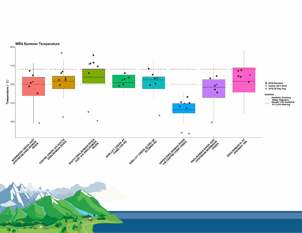
1. CWMN sample sites in Water Region (WR) 4
2. How to interpret a box plot
3. Box Plot Comparison 2019 data to previous
years:
Graphs displayed per parameter
(Temperature, Dissolved Oxygen, Turbidity,
Conductivity) per sample period (summer
and fall)
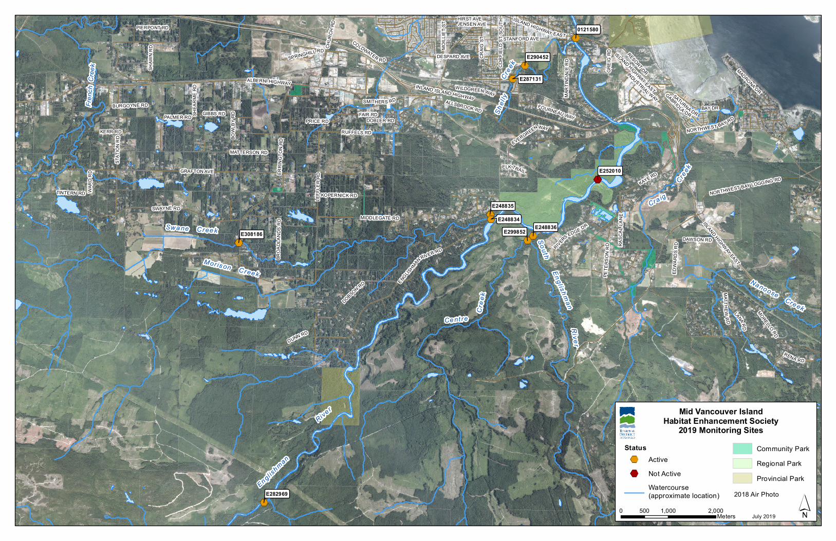
4. MVIHES CWMN map of sample sites
Created for the RDN’s Community Watershed Monitoring Network for the May 2020 Results Session. Question? Call 250-390-6560

CWMN Sample Sites in WR 4:
The table below shows the group(s) and sites monitored, as well as the number of years and which years a site was sampled. The number of years is important to keep in mind when interpreting the box plots as the plot for each site may contain a slightly different temporal range.
Group EMS ID Geographic Description Years
Sampled* Years
Monitored
MVIHES E282969 Upper Englishman River u/s Centre Fork Creek 9 2011 - present
MVIHES E308186 Swane Creek d/s of Errington Road 6 2014 - present
MVIHES E248835 Morison Creek U/S from Englishman River 9 2011 - present
MVIHES E248834 Englishman River U/S from Morison Creek 9 2011 - present
MVIHES E299852 Centre Creek, just upstream of the confluence
with S Englishman 6 2014 - present
MVIHES E248836 South Englishman River u/s from Englishman River 9 2011 - present
MVIHES E287131 Shelly Creek @ Hamilton Road 6 2014 - present
MVIHES 0121580 Englishman River at Highway 19A 9 2011 - present
MVIHES E290452 Shelley Creek at end of Blower Rd. 5.5 2014 - present~
*The number of years sampled up to and including 2019.~Fall 2015 was not monitored in order to complete restoration work.

How to Interpret a Box Plot:


Engl ishman
Cra ig
Swa ne C ree k
South
Mor is on C ree kNanoose Creek
Shel l
yCre
ek
Rive r
Engl ishmanRive r
Creek
Ce nt re
Cree
k
Frenc
h Cr
eek
ISLAND HIGHWAY EAST
MART
INDA
LE R
D
NORTHWEST BAY LOGGING RD
CORF
IELD
ST S
OUTH
LEFF
LER
RD
BAY DR
DESPARD AVE
WARD
RD
GREI
G RD
JENSEN AVE
ELK TRAIL
DOBLER RDKERR RD
PALMER RD SHEA
RME
RD
EVERGREENWAY
RASC
A LLA
N E
LANARD
DUNN RD
GIBBS RD
TINTERN RD
EDWA
RDS R
D
RENA RD
MOILL
IET S
T
DAWSON RD
KOPERNICK RD
BROA
DLAN
DS R
D
BURGOYNE RD
INDUSTRIAL WAY SATURNA DR
BOWL
BY R
D
PIERPONT RD
SMITHERS RDGABRIOLA DR
RESORT DRSHAW
N RD
FAIR RD
CRAIG
ST
MADRONA DR
SPRINGHILL RD
WILDGREEN WAY
CHUR
CH R
D
PET E
RSON
RD
RUFFELS RD
MATTERSON RD
FOURNEAU WAY
RIVERS EDGE DR
STANFORD AVE
ALBERNI HIGHWAY
NORTHWEST BAY RD
COLDWATER RD
ISLAND HIGHWAY EAST
DOBSON RD
HIRST AVE
MATT HE WRD
ISLAND HIGHWAY EAST
STAT
ION
RD
MORELLO RD
PRICE RD
KAYE RD
SWAYNE RDMIDDLEGATE RD
ENGLISHMANRIVER RD
ALLSBROOK RD
GRAFTON AVE ERRI
NGTO
N RD
INLAND ISLAND HIGHWAY
E282969
E248836
E252010
0121580
E290452
E287131
E248835
E308186
E248834E299852
Mid Vancouver IslandHabitat Enhancement Society
2019 Monitoring Sites
0 1,000 2,000500 Meters
StatusActiveNot ActiveWatercourse(approximate location)
Community ParkRegional ParkProvincial Park
July 2019
2018 Air Photo