Embed Size (px)
Citation preview
7"3COMMONWEALTH OF AUSTRALIA
DEPARTMENT OF NATIONAL DEVELOPMENT
BUREAU OF MINERAL RESOURCES, GEOLOGY AND GEOPHYSICS
Record 1965/112
ccfroy
0 18254
GEOLOGICAL REPORT ON THE GREAT DAVENPORT, GOLD PROSPECT
KURUNDI GOLDFIELD.
byW.S. Yeaman
The information contained in this report has been obtained bythe Department of National Development as part of the policyof the Commonwealth Government to assist in the explorationand development of mineral resources. It may not be publishedin any form or used in a company prospectus or statement withoutthe permission in writing of the Director, Bureau of MineralResources, Geology and Geophysics.

GEOLOGICAL REPORT ON THE. GREAT DAVENPORT GOLD PROSPECT
KURUNDI GOLDFIELD.
CONTENTS~
SUMMARY
INTRODUCTION.
HISTORY.
.' . '.~)
REGIONAL GEOLOGY.
by W. S. YEAMAH.
RECORDS 1965/112
DETAILED GEOLOGY AND ASSAY RESULTS Structure of QUartz Reefs Mineralogy Gossan Assays
CEOCHEMISTRY Gossans Geochemical Drainage Prospecting.
. RECOMMENDATIONS CONCLUS IONS REFERENCES APPENDIX I 3 Mineralogical investigation of two rooks
. from the Davenport Range Area. N.T.
1
1
1
2
2
3
3
3
5 5 6
6
7 7
PLATES~ Plate 1: Locality Map. Scale 8 milos, ~~~.,inoh.
Plate 2: Photogeological and locality map, portion of Kurundi Goldfield. . Photo Scale (approximately 1:50,000)
Plate 3: Great Davenport Gold Prospect Scale 40 feet = 1 inch.
The information contained in this report has been obtained by the Department of National Development, as part of the polioy of the Commonwealth Government, to assist in the exploration and development of mineral resources. It may not be published in any form or used in a company prospeotus without the permission in writing of the Direoto~,Bureau of Mineral Resources, Geology and Geophysios.

SUMMARY:
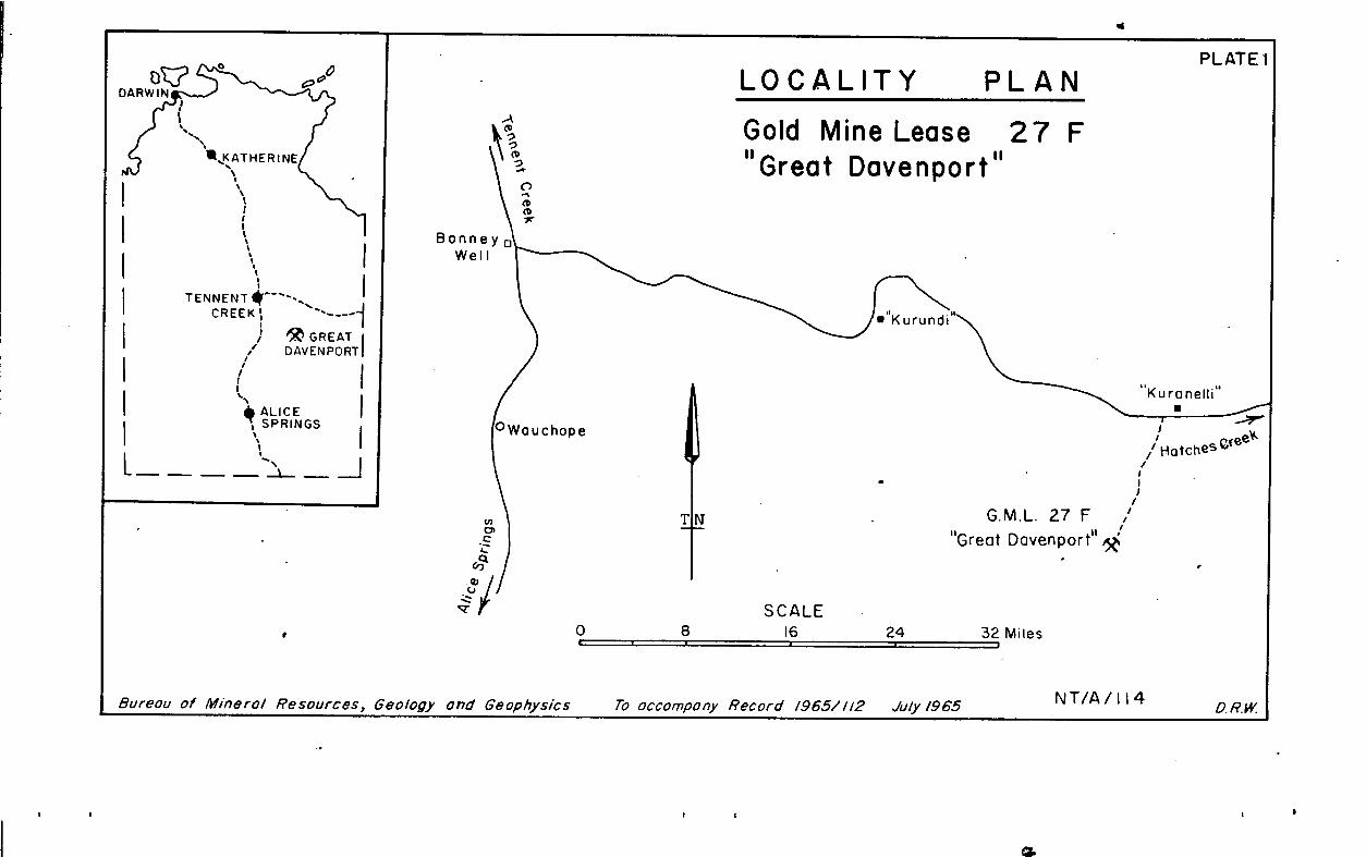
The Great Davenport is an auriferous quartz reef situatedabout 90 miles south-west of Tennant Creek on the northern flanksof the Davenport Ranges in the Northern Territory.
The reef is located near the intersection of a north-north-east trending normal fault with an arcuate anticlinal axis plung-ing to the west-north-west. There appear to be two periods offolding and the maximum age of the mineralisation is tentativelyassigned to the later period. Distribution of gold values appearsto be highly erratic; visible gold associated with pyrite andpyritic boxworks occurs near the anticlinal axis at the south-south-west end of the reef. Gabbro crops out close to severalother auriferous reefs in this general area, and it is suggestedthat the mineralisation derives from a basic igneous source.
Wagon drilling is recommended to provide more informationon structure and distribution of gold. It is also recommendedthat repetitions of the localising structures should be examinedHttnEegl' oBtigcale. Geochemical studies of gossans and prosp-
reefs associated with gossans is also recommended.
INTRODUCTION:
The Great Davenrort Gold Prospect is situated on thenorthern side of the main wategshed of the Davenport Ranges atlongitude 13419'E latitude 20`145.6'S, 10.2 miles on a truebearing of 200 from Kurennelli. It is accessible by road fromKurundi Station by taking the Kurennelli track to a point aboutone mile west of Kurennelli, and then following a graded trackfor about twelve road miles in a south-south-westerly direction.(Plate 1.)
HISTORY:
Mr. Charles Priester, a local prospector, discovered theprospect by dollying and panning in January 1964, and pegged itin March of the same year. It was subsequently sold on optionto a syndicate consisting of Messrs. G. Farrel, G. Barton,A.F. Campbell and H. V. Leonard. Peko-Wallsend Investments Ltd.,later negotiated an agreement to carry out a comprehensiveprogramme of exploration and to acquire a controlling interestif the results are encouraging.
REGIONAL GEOLOGY.
The country rocks consist of dominantly arenaceoussedimentary rocks which are part of the Hatches Creek Group(Smith et al 1960). They are predominantly medium to coarse-gila;Rphax 5Vm s current-bedding, and are generally silicified
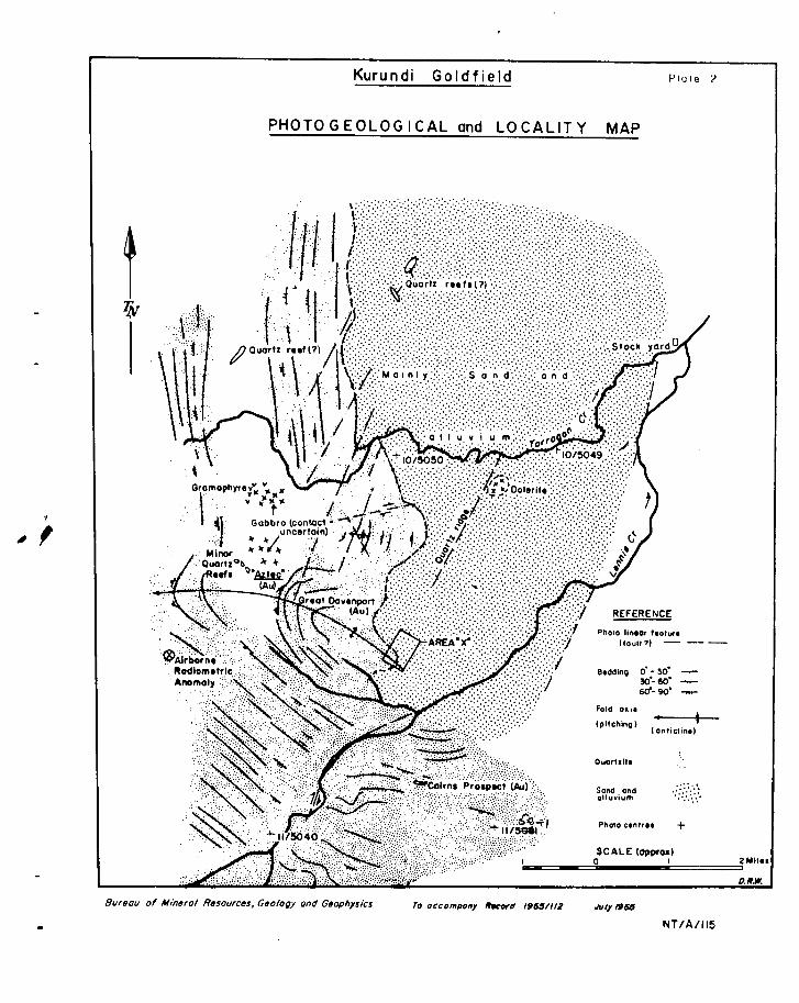
The Graat Davenport Gold Prospect is a quartz reef, orseries of reefs, located near the intersection of the axis of abroad anticline, which plunges at 30 to the west-north-west,and of an east-north-east trending linear feature, which isthought to be a fault. (Plate 2.)
The trace of the anticlinal axis is curved, convex to thenorth. The north-north-east-trending linear feature appears tobe confined to the convex (north) side of the anticlinal axis,and it may represenenormal fault which developed as a tensionopening during the southward bending of the anticlinal axis bya later period of cross-folding.
To the west-north-west. the Great Davenport anticline appears
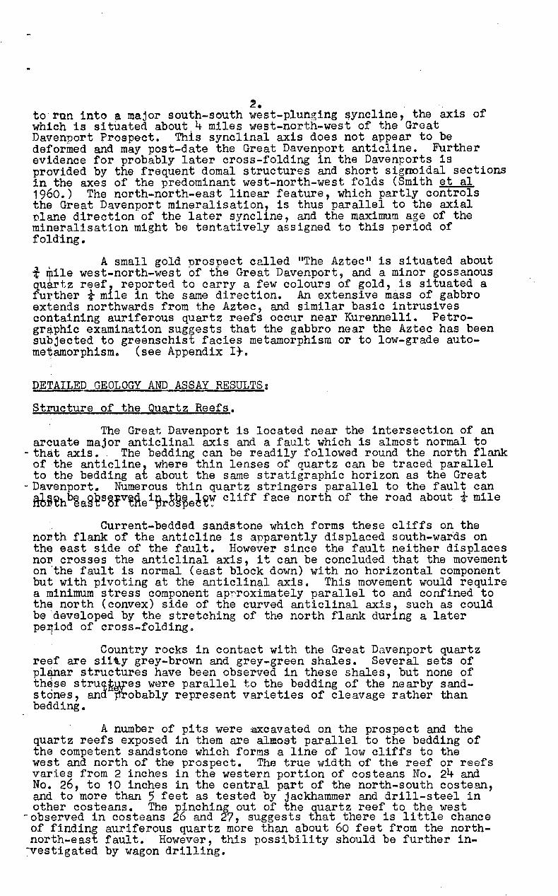
~. to'run into a major south-south west-plunging ~yncline, the axis of which is situated about 4 miles west-north-west of the Great Davenport Prospect. This synclinal axis does not appear to be deformed and may post-date the Great Davenport anticline. Further evidence for probably later cross-folding in the Davenports is provided by the frequent domal structures and short signoidal sections in the axes of the predominant west-north-west folds (Smith et al 1960.) The north-north-east linear feature, which partly controls the Great Davenport mineralisation, is thus parallel to the axial plane direction of the later syncline, and the maximum age of the mineralisation might be tentatively assigned to this period of folding.
A small gold prospect called "The Aztec ll is situated about t ~ile west-north-west of the Great Davenport, and a minor gossanous quartz reef~ reported to carry a few colours of gold, is situated a further t mile in the same direction. An extensive mass of gabbro extends northwards from the Aztec, and similar basic intrusives containing auriferous quartz reefs occur near Kurennelli. Petrogr~phic examination suggests that the gabbro near the Aztec has been subjected to greenschist facies metamorphism or to low-grade autometamorphism. (see Appendix It.
DETAILED GEOLOGY AND ASSAY RESULTS:
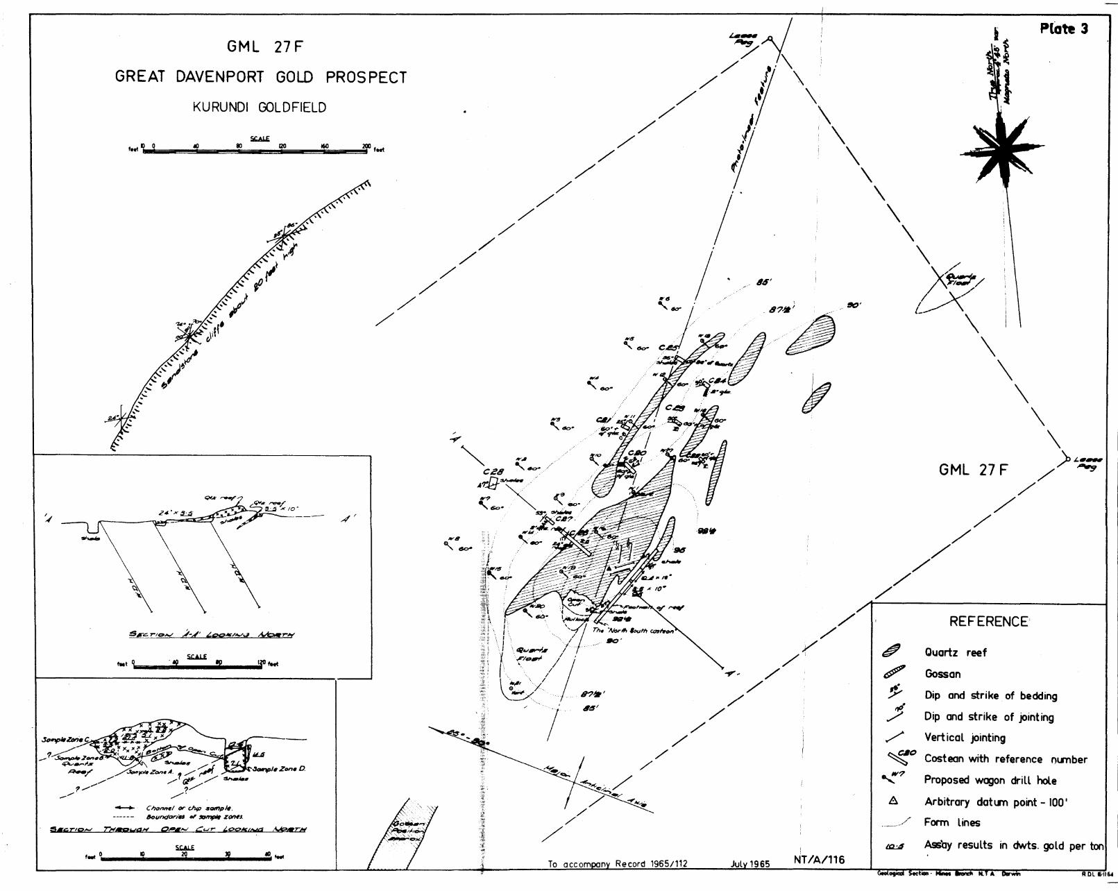
Structure of the Quartz Reefs.
The Great Davenport is located near the intersection of an arcuate major anticlinal axis and a fault which is almost normal to
- that axis. The bedding can be readily followed round the north flank of ,the anticline 1 where thin lenses of quartz can be traced parallel to the bedding at about the same stratigraphic horizon as the Great
-Davenport. Numerous thin quartz stringers parallel to the fault can M~~hb~a~£s3FVtHei~r~H~e6~~ cliff face north of the road about t mile
" Current-bedded sandstone which forms these cliffs on the no~th flank of the anticline is apparently displaced south-wards on the east side of the fault. However since the fault neither displaces no~ crosses the anticlinal axis, it can be concluded that the movement on 'the fault is normal (east block down) with no horizontal component but with pivoting at the anticlinal axis. This movement would require a minimum stress component ap~roximately parallel to and confined to the north (convex) side of the curved anticlinal axis, such as could be developed by the stretching of the north flank during a later pe~iod of cross-folding. ,
, Country rocks in contact with the Great Davenport quartz reef are si1~y grey-brown and grey-green shales. Several sets of pl4nar structures have been observed in these shales, but none of th~se stru~~Mtes were parallel to the bedding of the nearby sandstones, and ~obably represent varieties of cleavage rather than bedding.
A number of pits were ~cavated on the prospect and the quartz reefs exposed in them are almost parallel to the bedding of the competent sandstone which forms a line of low cliffs to the west and north of the prospect. The true width of the reef or reefs varies from 2 inches in the western portion of costeans No. 24 and No. 26, to 10 inches in the central part of the north-south costean, and to more than 5 feet as tested by jackhammer and drill-steel in other costeans. The pinching out of the quartz reef to the west
-observed in costeans 26 and 27, suggests that there is little chance of finding auriferous quartz more than about 60 feet from the northnorth-east fault. However, this possibility should be further in~vestigated by wagon drilling.
3· STRUC~ OF THE QUARTZ REEFS (eel'ltil'lued)
Mineralogy.
The gold occurs as flake and as coarse gold. The flake gold is thought to.be of secondary origin and commonly forms short flakes up to 1/8 inch long on fracture and joint planes in otherwise barren white quartz. The coarse gold is thought to be of primary origin and is associated with fine-grained pyrite, pyritic boxworks and with rose-red, lemon-yellow and dull grey varieties of quartz. Geochemical investigation of the nearby gossan showed an absence of arsenic (see below), so that the sulphides in tne quartz reef are probably also free from arsenic. Kaoliniti~~. films are well developed on joint planes in the auriferous quartz.
Gossan.
Red hematitic gossanous material occurs over a width of a90ut eight feet in a shallow gully about 350 feet south of the open cut. The ground between the gossan and the reef is scree covered, so that the structural relation of the gossan to the quartz reef is not known. A random grab sample of gossan assayed 1.3 d~ts gqld per ton. The gossan therefore warrants some further investig~tion, as it may be derived from pyritic material such as occurs i~ association with the primary gold in the open cut.
Assays. (Plate 3.)
The best assays were obtained from the open cut and from the north-south costean, but very poor results have been obta~ned elsewhere in the reef. However, too much significance should not b~ given to the results of individual determinations since th~ very patchy distribution of the gold shows that only bulk sampling: would provide a satisfactory over-all assessment of the prospect. Some of the small pockets of rich primary material are estimated, by panning, to contain up to 10 ounces of gold per ton.
A. OPEN CUT (horizontal chip samples).
ASSAYS (dwts gold per ton.)
0 feet to 4 feet 17.6 17 feet to 23 feet 2.2 23 feet to 27 feet 5.1 27 feet to 31 feet 27.9 31 feet to 35 feet 1.2
(N.B. 0 feet = East wall of north-south costean)
B. OPEN Cll! (chips at 8-inch centres).
ASSAYS (dwt gold
Sample Zone A. Sample Zone B. S ample Zone C.
11 .4 3.3 2.0
per ton).
C. NORTH SOUTH COSTEAN, (90 feet long costean on south-east side of the reef) (Chip samples).
23 feet to 36 feet, over 10 inches true vertical width 10.4
39 feet to 53 feet, over 10 inches true vertical reef width 3.5
4.
C. NOHTH SOUTH COST8A:.:J (continued)
(t~.B. o feet = north-east end of· tha costean. No samples ... .,ere taken in this costenn except in these h..ro zones, ond ,,·!here the open cut adjoins this coste an, as the reef is not exposed in 'rertical section outside these zones).
D. NOHTH SOUTH COSTE:A,:i'~ (channel sample)
Vertical cha.nnel sample over 4. f8at of reef exposed, on east wall of costean, opposi te junction of costean and open
ASSAYS (dwts.gold per ton).
cut 14. 5
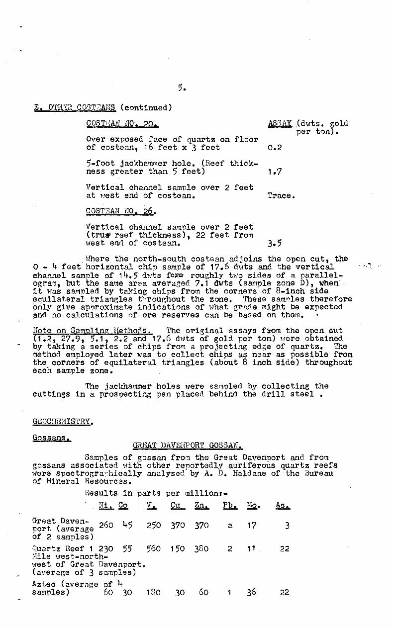
E., OTHE:R C03'r:~AHS.
COSTgAH NO. 27.
Over exposed face 0" quartz lens, 1 foot x 2 feet, at east end of costean.
8-inch intersection in jack ha'nmer hole
COSTEAN NO. 24,
Not sampled, only 2 inches thickness of quartz exposed.
C OS 'T' ;:rAJ\T fTO , i .•• ;J " ..... ••
0.9
Trace.
Over exposed face of quartz on costean floor, 7 feet x 4 feet. Trace.
5~foot jackhammer hole in floor of costean, at right angles to exposed face on floor (Heef thickness gres.ter than 5 feet). Trfl.ce (estimated
by panning)
COSrrii:At.f NO, 22.
OYer exposed. face of quartz on floor, 6 feet x 3'feet Trace.
5-foot jackhammer hole. (Reef thickness greater than 5 fe(:)t) Trace (estima.ted
by panning)
COSTIi.:AN NO, 21.
Over exnosed face of quartz on floor, 7 feet x 3 feet. Trace.
5-foot Jackhammer hole. (aeof thi~kness greater than 5 feet) 0.8
5.
E, O'rI-l'~a COST:~Al'JS (continued)
Q.0STi1:AN HO', 20. ASr3AY Jd,.,ts. ~old per ton).
Over exposed face of quartz on floor of costean, 16 feet x 3 feet 0.2
5-foot jackhammer hole. (Reef thick-ness greater than 5 feet) 1.7
Vertical channel sample over 2 feet at "!est end of costean. Trace.
C OSTEAN NO. 26.
Vertical channel sar(1ple over 2 feet (truS'reef thickness), 22 feet from ",est end of costaan. 3.5
,vfuere the north-south costean adjoins the open cut, the o - 4 feet horizontal chip sample of 17,6 d"rts and. the vertical ' ' /.; channel sample of 14. 5 d~'Tts foPJjl' roughly h!o sides of a pare~lelogra'll, but the same area avera~ed 7.1 dwts (sample zone D), when', 1 t ,"'as sal'Tlpled by ta.king chips from the corners of 8-inch side ~qullateral triangles throughout the zone. These samryles therefore only give ap~rox:f.mate indications of Hhat grnde might be expected ~d no calculations of ore reserves can be based on them.
Note on s_a~ing Hethods. The original assays f~m the open Gut ( 1 .2, 27.9, .1, 2.2 and 17.6 d'lilts of gold per ton) 'htore obtained by taking a series of chips from a projecting edge of qua.rtz. The method employed later was to collect chips as near as possible from the corners of equilateral triangles (about 8 inch side) throughout each sample zone.
The jackhammer holes ",rere sampled by collecting the cuttings in a prospecting pa.n placed behind the drill steel •
GEOCITi~NIS'l\RY •
Gossans. GR1~AT DAVENPORT GOSSAN,
Samples of gOssan from the Great Davenport and from gossans associated \01i th other reportedly aur:lferous quartz reefs ,-rare spectrogra:~,hically analysed by A. D. Haldane of the Bureau of t1inera.l Resources.
Hesults in parts per mill1on:-, ;~a. QQ. Y.&- eu - Zn. Pb. Mo. ~
Great Daven- 260 45 250 370 370 a 17 3 port (average of 2 samples) Quartz Heef 1 230 55 560 150 380 2 11 22 Mile west-north-west of Great Davenport. (average of 3 sa~ples) Aztec ( avera.ge of 4 samples) 60 30 130 30 60 1 36 22
6.
GREA~r DAV[;NPORrJ~ GQ.3SA!:·Y (continUed)
&.... Co Y... ~ .~ .. ·Pb·· Ho As -. - .,-UrD.li tis00 and satlssuritised 150 50 100 a. 200 a gabbro a.(l~ace.nt to Aztec 1 Sample) Granophyre 9.ssacinted \IIi th this gabbro (1 sample) 10 10 7 a 30
NOTE: (-) = not sought. (a) = sought, but not detected.
. Gold \"as recognised spectrographica.lly in the samples from the Aztec prospect. The close association of aur." r'erous quartz reefs and gabbro at the Aztec and also at 1\uren~lti suggests that the gabbro may be the source of the mineralisation which was responsible for the gossans associated ,dth the quartz reefs. However, it is surprising that lead, which is present in significant a1110unts in the gabbro, is almost absent from the gosslVls, while zinc f ad t Ailild iUii, which occur(in all the gossans, aJIIIfIJ" kJ fl,bsent frOID the gabbro.
?eochemicat Drainage .Prospeytlng,
Strea'1'l silt from creeks draining the Grea.t Davenport :J.ndicated a background of 6 p.,p • .rn. Cu, "lith 10 p.p.m. eu closer to the prospect. Although these results indicate an anomaly, the contrast is very low andi t is doubtful ,:!hether the method would be a reliable exploration technique.
Rl!;COt1HENDATIONS:
A programt':1.e of '"agon drilling is proposed, !!lainly in order to determine if the reef extends dOl'Tn the pitch of the anticline. If the drilling sh0'\1s that the quartz reef, or reefs, do not extend. for any great distance. down the pitch of the anticline, the only chance of findin3 a reasonable tonnage ",ould be by locating additional reefs which might exist down the line of the fault. It is therefore proposed that a waggon drilling progra~rne should be carried out as follm-ls:
(A) Drill H.D.H.1 vertically to 200 feet. If no additional reefs are located at depth, all subsequent holes can be shortened accordingly.
(B) ~v .D.H.· s 3 to 20 have been aesigned to cover the y.lossible extensions of the kno\-rn reefs down-dip to the west and along strike to the north and south. However some of these holes may not be required if early resuits show that the extent of the reefs is limited in any particular direction.
(C) The ground between the reefs and the gossan should also be tested by costeaning and by drilling \11. :).H.21 • Addi tional holes may be required if encQur:J.ging results are obtained in this area.
(D) Detailed lnapping should be extended to include the gossan, and, since the gossan is probably derived from a highly 'conductive ~yritic lode, an electromagnetic or induced potential geophY~icai· survey might assist in locating extensions or repetitions of this lode.
CONCLUSION.
The Great Davenport Gold Prospect is an auriferous quartz reef located near the intersection of a west pitching anticline and a fault. Most auriferous quartz reefs located to date in the Davenpprt Ranges are associated with gossans and occur in or near gabbro, suggesting that the Great Davenport mineralization may have been genetically related to gabbro.
It is impossible to state the economic potential of the Great Davenport prospect on the information available at present, but further investigation by wagon drilling is recommended to establish its geometry and reserves. Costeans and wagon dr:t.ll holes should also be ~ut down between the quartz reef and the gossan to the south in order to determine their relationship and to determine the southern limit of pay values. The gossan is auriferous, and may be derived from oxidised pyritic materi~l; so that it also warrants further investigation.
On a regional scale it appears that, in this area, there is no substitute for traditional dollying and panning techniques.
Particular attention should be paid to quartz reefs associated with gossans. The gossans should also be investigated ~d routine spectrographic analyses of samples are recommended. The presence of gossans suggests that electrical geophysical ~ethods may be of value in this area for locating non-outcropping pccurrences of pyritic ore.
Any repatitions of the intersection of the structural features which control the mineralization at the Great Davenport prosnect should be thoroughly investigated..
Photogeological interpretation in the vicinity of the gossanous auriferous quartz reefs at the Aztec prospect suggests that they conform to such control.
About 1 t miles south-south-east'I.'lards along the Great Davenport anticlinal axis there is a sand covered area (Area.~Plate 2.) into which a pronounced north-north-east feature appears to be heading. If electrical geophysical methods are found to work satisfactorily at the Great Davenport, this area should also be investigated by such methods.
REFERENCES.
SMITH, K .. R. t STEWART, J oR. , and SMITH, J.W., 1960
The Regional Geology of the Davenport and Murchison ' Ranges, Northern Territory. Bureau of Mineral ReSources, Australia.. Report 5 .

APPENDIX I.
Extract from Report No o 14.
File No. 198NT/1
September 9th, 1964.
MINERALOGICAL INVESTIGATION OF TWO ROCKS FROM
THE DAVENPORT RANGE AREA, NORTHERN TERRITORY
- by -
I. R. PONTIFEX
Samples submitted by W. S. Yeaman. Spectrographic analyses done by A. D. Haldane on the optical emission spectrograph.
Field No o 0060232.
Localitye One mile west of Great Davenport Gold Mine. Registered Noo AAD788: Slide No. 14300. Sp~ctrographic analysis, values in npm. (a= absent)
Ni 150
Conclusionst
Co 50
Zn Cu Pb a 100 200
Ag a
Au Mo a a
This rock is essentially a uralitised, saussuratised - gabbro. It contains accessory hematite, pyrite, and minor
accessory grains of a possible nickel or cobalt sulphideo
I The alteration of the rock may have been induced by autometasomatism during the last stages of magmatic crystal~isation or by a subsequent phase of low grade regional or cont~ct metamorphism.
The values of Ni,Co and Cu are within the average· range of values for these elements in this rock type; therefore t~ey are not necessarily indicative of inherent, economic concentrations. The Pb content is about 20X the average Pb content in this rock type.
Macro description'
A grey green medium-grained crystalline rock with a brown iron-stained weathered surface. Several fine pyrite grains are ev,ident.
Petrographic description:
An igneous rock; it has a predominantly hypidiomorphic texture with an average grain size of about 1.5 mm. The main components are pyroxene and feldspar, both are extensively altered.
The original pyroxene euhedra are replaced to varying degrees by irregular alteration corona of uralic hornblende. This
- mine~al is generally fibrous and some grades imperceptibly into cavities filled with chlorite and minor actinolite. The composite grains or pyroxene and amphibole make up about 50% of the rock.

2.
The feldspar laths meastre up to 2 mm. long and 0.5 mm.wide, all are densely clouded with alteration products, mainlysericite with minor, scattered epidote. Indefinite twinning insome relic grains sug7,ests that the felspars were originally abasic plagioclase: however, the a. I. of others indicates thatthey are albitic.
Interstitial fill materiel through the rock consists ofsericite, chlorite, calcite and minor actinolite. Skeletal opaquegrains make up about 2, of the section.
Mineragronhic descrirtioq:
The majority of the opaque grains consist of hematite,these measure up to 1 mm. Accessory amounts of a white mineralwith a slightly yellow and rarely, pink tint and slightlyanisotropic occur in skeletal grains up to 0.02 mm. in maximumdimension. Some have an indefinite twinning. The extremelylimited abundance of this mineral made a positive identificationImpossible. On the basis of its optical properties and mode ofoccurence it is sug , ested that it may be c nickel or cobaltmineral.
Field No, 0060233
Locality^: One mile west of Great Davenport Gold Mine. ThisIs an acid differentiate of 0060232 (Yeaman).
Registered No.^AA0729. Slide No. 14301.
Spectrographic analysis, values in PPwl•
Ni^Co^Zn Cu Mo Pb Ag Au10^10^a^7^5^30 a^a
Conclusions:
This rock has the mineralogic-1 composition of a fine-grainedgranite, the incipient graphic intergrowth of quartz and feldspar,however, suggests that it is more specifically a granophyre or felsite,rossibly extrusive.^On a mineralogical basis the most likay sourceof this rock is an acid igneous magma.
The values of elements detected by the spectrograph arewithin the average range of values of these elements for this rocktype.
Macro description:
A pink, light brown fine-grained crystalline rock containingpink felspar, quartz and minor chlorite. It has a light brown whitespotted weathered surface.
Petromamhic description:
This section has a predominantly g,ranophyric texture withan average grain size of about 0.3 mms. The lain minerals arequartz and altered felspar with minor chlorite and eridote.
Quartz makes up about 45; of the rock and occurs inallotriomorphic granular aggregates through the section.
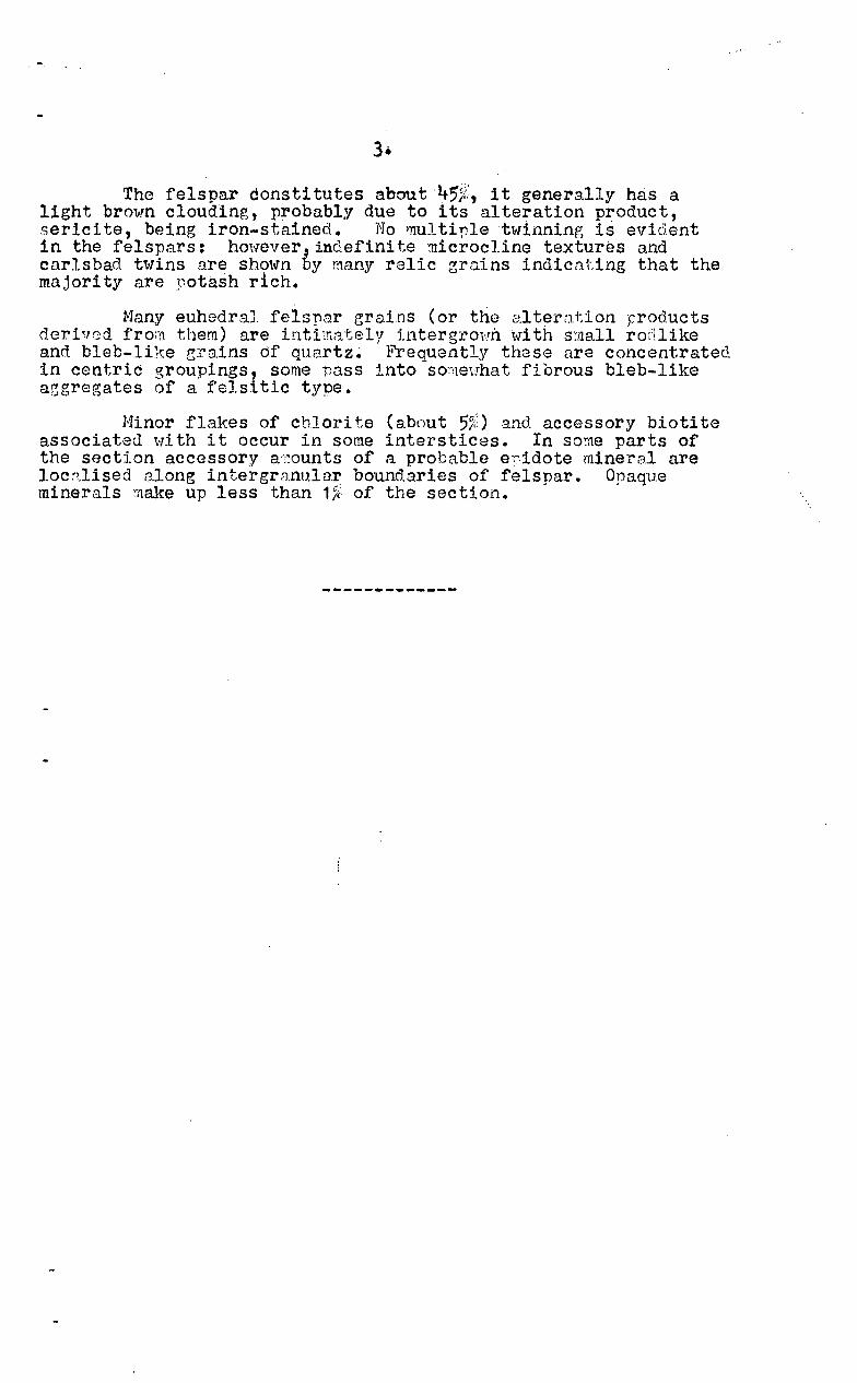
The felspar cansti tutes about 45ji:, it generally has a light brown clouding, probably due to its alteration product, sericite, being iron-stained. No l!lultir-Ietwinning is evident in the felspars: hmrever indefinite "1licrocline textures and carlsbad twins!J.re shmoJ'n ~y many relic zr.'lins indicnting that the majority are ~otash rich.
Many euhedral felspar grains (or tria alteration products dcrivfJd fron} them) are intimately i.ntergrOil11. 'tvi th small ro('llike and bleb-like r,:rains of quartz~ li'requently these nre concentrated in centric groupings, some nass into sO:"rleuha t fibrous bleb-like azgregates of a felsitic type.
Hinor flakes of chJ.ori te (about 55;;) and accessory biotite associated ",i th it occur in some interstices. In sorae parts of the sectton accessor,V a'-;1ounts of a probable e,idote minera.l are locn.lised along intergranular boundaries of felspar. Opaque minerals make up less than 1>(, of the section.
TENNENTCREEK 1
GREATDAVENPORT'
6 ALICESPRINGS
PLATE1
Bureau of Mineral Resources, Geology and Geophysics NT/A/I14To accompany Record /965/112 July /965^ D.R.W.
G.M.L. 27 F"Great Davenport" "56
•
TIM
SCALE160 8 24 32 Miles
Gold Mine Lease 27 F"Great Davenport"
"Kuranelli n
ee*Hatches
LOCALITY^PLAN
iGramophyree;
1 tI^
v kx vtv t l. ,-2,—
Gabbro (contact .■ 7*uncertain)
Mino^
. i.7.^k V Ik.^r^71^k
•'Oua tz e6, *-I.• sofa ""^. •
REFERENCE
Photo linter feature(faun 7) — — —
NT/A/115
.5~ZM.C /
_7~z_.". .p..... .......... ~/
1,/'/
_/
,/'/
GML 27 F
GREAT DAVENPORT GOLD PROSPECT
KURUNDI GOLDFIELD
5UL£ t.et Q ., ,
- el1o"",; Dr chip sompJ •. ~lIndon" '" ~ z~s.
--
SllertpH T....-.pWQI'f ~«.-- C<.J'r" L.P0tfCttW4 r\A?«rH
~~- j ".
~~ / ,.\ / fJ \
/' " \ /"/ \ \ / ll. 1\
/ . /" I \
Plate 3
/' ( \ /' . \
/"/ / \ /" \
/
.",., . 84'
.. "'.... .. ~ \ 11'6 . . ~_:::::-:::;::; 'do- e." -.- - -" ..... __ -:=:=--," , .," .
.... ' -- ... .;....". ~_:C \
eo .... .,..
/' /'
/' /'
-9'~ /'
/'
/" /"
/ /'
;/' /'
\ \ >t..~
GML 27F /" ~ /
/ /
/' /'
// /
REFERENCE
G1P Quartz reef
~ Gossan ~.
7' Dip and strike of bedding
.:!f Dip and strike of joint ing
../ Vert ical jointing
~c Cost eon with reference nllllber
"':'7 Proposed wagon dri II hole
A Arbitrary dotllll point - 100 I
/" Form lines
AfEtoy results in dwts. gold per ton To accom n Record 1965/112 Jul 1965 NT IA/116
.Oll6·U64


![AMS GIAU YES O AUSAIA YMEOEA II - Queensland Museum/media/Documents/QM/About+Us/Publications/... · AMS GIAU YES O AUSAIA YMEOEA II ^11. wig "S Aus" "hr b/l. Giau 9 [G1-1]" QM 1 sage](https://img.dokumen.tips/doc/110x75/5aa06a057f8b9a84178e1d45/ams-giau-yes-o-ausaia-ymeoea-ii-queensland-mediadocumentsqmaboutuspublicationsams.jpg)


![AMS GIAU YES O AUSAIA YMEOEA III - Queensland Museum/media/Documents/QM/About+Us/Publications/... · AMS GIAU YES O AUSAIA YMEOEA III ^57. a eso [= Gooae] Q ue 1913 a a i i uy. QM](https://img.dokumen.tips/doc/110x75/5aa06ad17f8b9a7f178e0e76/ams-giau-yes-o-ausaia-ymeoea-iii-queensland-mediadocumentsqmaboutuspublicationsams.jpg)


![AMS GIAU YES O AUSAIA YMEOEA II 1 9 Giau 19/media/Documents/QM/About Us/Publications... · AMS GIAU YES O AUSAIA YMEOEA II ^1. rttpnn . Gi ye 9 [G] E i e Ag & Sk Q1" Ca - 1 . 9 (?](https://img.dokumen.tips/doc/110x75/5d33b6e588c993ff1f8d77b4/ams-giau-yes-o-ausaia-ymeoea-ii-1-9-giau-19-mediadocumentsqmabout-uspublications.jpg)


