Embed Size (px)
Citation preview

Climate Change Reporting:
Impact of Climate on Rural Communities in Bhutan
| 1 |Climate Change Reporting: Impact of Climate on Rural Communities in Bhutan
Impact of Climate on Rural Communities in Bhutan
Climate Change Reporting:

| 2 | Climate Change Reporting: Impact of Climate on Rural Communities in Bhutan | 3 |Climate Change Reporting:
Impact of Climate on Rural Communities in Bhutan
Contents
FeaturesBackground Selected grantees with the mentors for Climate Change Reporting Grant
The lost mandarin growersof Bhutan
Danger of wrathful watersin Lhuentse
Pangtse shing benefits ruralcommunities but faces threatfrom deforestation
Conserving water resourceswith PES, an example fromYakpugang
A fungus, A Community and its Culture
Water shortage a national concern
Containing our glacier-laketicking time bombs
Trading White Gold
05
07
21
24
11
33
39
44
15
36
ཆུ་རྐ་ཡུན་བརྟན་གནས་ཐབས་ལུ་སྤྱོད་འཐུས་ལམ་ལུགས་གཞི་བཙུགས།༢༩
Haaps fear extinction of yak herding practice

| 4 | Climate Change Reporting: Impact of Climate on Rural Communities in Bhutan | 5 |Climate Change Reporting:
Impact of Climate on Rural Communities in Bhutan
Bhutan Media Foundation (BMF) completed its first round of Climate ChangeReporting (CCR) Grant within the period of four months from August to November,2020. The main objective of CCR Grant is to produce well-researched, in-depth stories on the impact of climate change on vulnerable rural communities of Bhutan.
The grant has sent the eight reporters across the length and breadth of the country pursuing various climate change stories. Travelling across rural Bhutan is always challenging. This year, it was made worse by travel restrictions due to COVID-19. Yet, the reporters persevered and the result is a critical mass of stories climate change stories. The stories were also possible due to the guidance of three mentors who sharpened the focus, improved the structure, and added depth to the stories.
In the second round of the grant, the same grantees will link their climate change stories with the public policies of the country, thus completing the narrative.
A total of eight stories, including two documentaries, were produced and published/aired across the Bhutanese media. The Climate Change Reporting Grant is funded by Earth Journalism Network under the project titled ‘Linking Climate Change Reporting with Public Policy’.
>> Selected grantees with the mentors for Climate Change Reporting Grant
Background
BHUTAN MEDIA FOUNDATION | 2020 |
| 6 | Climate Change Reporting: Impact of Climate on Rural Communities in Bhutan | 7 |Climate Change Reporting:
Impact of Climate on Rural Communities in Bhutan
>> Selected grantees with the mentors for Climate Change Reporting Grant
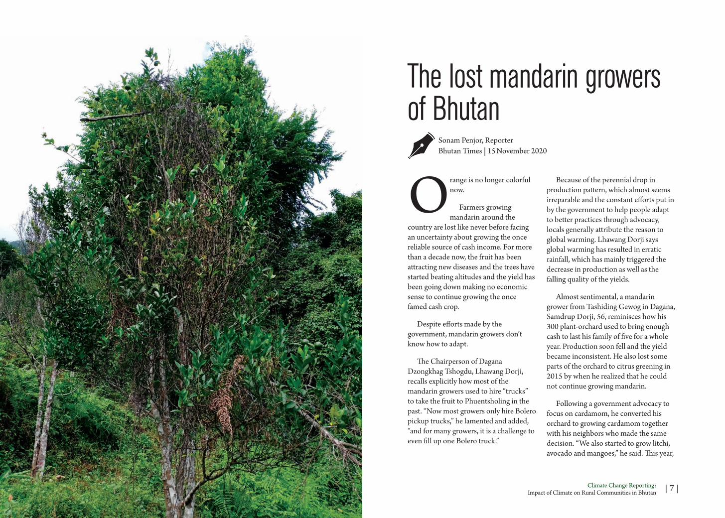
Orange is no longer colorful now.
Farmers growing mandarin around the
country are lost like never before facing an uncertainty about growing the once reliable source of cash income. For more than a decade now, the fruit has been attracting new diseases and the trees have started beating altitudes and the yield has been going down making no economic sense to continue growing the once famed cash crop.
Despite efforts made by the government, mandarin growers don’t know how to adapt.
The Chairperson of Dagana Dzongkhag Tshogdu, Lhawang Dorji, recalls explicitly how most of the mandarin growers used to hire “trucks” to take the fruit to Phuentsholing in the past. “Now most growers only hire Bolero pickup trucks,” he lamented and added, “and for many growers, it is a challenge to even fill up one Bolero truck.”
Because of the perennial drop in production pattern, which almost seems irreparable and the constant efforts put in by the government to help people adapt to better practices through advocacy, locals generally attribute the reason to global warming. Lhawang Dorji says global warming has resulted in erratic rainfall, which has mainly triggered the decrease in production as well as the falling quality of the yields.
Almost sentimental, a mandarin grower from Tashiding Gewog in Dagana, Samdrup Dorji, 56, reminisces how his 300 plant-orchard used to bring enough cash to last his family of five for a whole year. Production soon fell and the yield became inconsistent. He also lost some parts of the orchard to citrus greening in 2015 by when he realized that he could not continue growing mandarin.
Following a government advocacy to focus on cardamom, he converted his orchard to growing cardamom together with his neighbors who made the same decision. “We also started to grow litchi, avocado and mangoes,” he said. This year,
The lost mandarin growers of Bhutan
Sonam Penjor, ReporterBhutan Times | 15 November 2020
| 8 | Climate Change Reporting: Impact of Climate on Rural Communities in Bhutan | 9 |Climate Change Reporting:
Impact of Climate on Rural Communities in Bhutan
he is worried nonetheless because his cardamom yield has also started dying. “We are really doomed,” he said.
Hundreds of kilometres eastwards to Shumar in Pemagatshel, Thinpay Sherab, 68, converted his 4-acre mandarin orchard a decade back to grow fruits like avocado, pomegranate, mango, and pineapple. Once a proud mandarin grower, he said the mandarin trees started dying for no reason. “I still don’t know the reason but I doubt global warming,” he says.
His orchard had about 1,000 mandarin trees and it fetched him an average of about Nu 200,000 more than a decade ago, which made him financially comfortable. It all ended abruptly. Thinpay Sherab noticed that mandarin trees were beating altitudes and growing in much colder areas where it never grew in the past “and it started dying in our areas which was historically al- ways ideal place to grow mandarin.”
With farm roads connecting Shumar only in 2012, Thinpay Sherab fondly recollects his entire life story of growing the fruit, carrying it personally and on horse backs to the nearest road point and then transporting it to Samdrup Jongkhar to auction it for export.
“I often fantasize how we would have conducted our mandarin business today with the roads connecting our village. It would have been such a lucrative business,” he shrugs.
Going further east to Kakpadung
With few exceptions, most mandarin growers are looking for alternatives as they are plagued by decreasing production, emergence of multiple diseases, trees dying for unknown reasons and many more.
village under Martshalla Gewog in Samdrup Jongkhar, a university graduate, Ugyen Dorji, 42, wonders how mandarin cultivation has literally died down in his village and also neighbouring villages in the gewog. “More than two decades ago, everyone in the gewog grew mandarin and it was the most reliable source of cash income,” He recollects, “today, only few growers remain and everyone has moved on to cultivating ginger,” and emotionally adds, “Mandarin business is dead.” Ugyen Dorji says that villagers could no longer hold on to cultivating mandarin as the crop had become unreliable to fetch cash income. “Production drastically dropped, a range of diseases crept in, quality became inferior, trees started dying and started growing at much higher altitudes, and it made no sense to continue growing the fruit,” he said, “those who continue growing mandarin do so because of
emotional reasons as the fruit trees had been the legacy of their family for more than one hundred years.”
In Mendrelgang in Tsirang, Sangay Lethro, 45, still grows about 100 mandarin trees but says he is very doubtful that the yield would bring in cash income. He attributes the main reason to erratic rain- fall and admits that the growing mandarin is not as profitable as in the past.
In Tsirang, the annual mandarin production in 2019 was 3,388 MT, which was a decrease from the previous year that saw 4,300 MT. Some major challenges in growing mandarin in Tsirang dzongkhag include deteriorating soil condition, old age of trees, poor management and pests and diseases, said the District Agriculture Officer, Dorji Gyeltshen.
The Gup of Tashiding Gewog in Dagana, Namgay Pelden, said that people are giving up mandarin cultivation and moving on to grow other fruits. She said that growers could still produce good yield if all advices of agriculture experts are followed.
Even district agriculture offices are constrained to offer effective interventions to growers. The District Agriculture Officer of Dagana, D C Bhandari said that District offices often lack the capacity to carry out detailed research for declining production.
While most mandarin growers all across the southern parts of the country face the similar predicament, there are
few pockets where the fruit is still giving a reason of hope to growers.
Over the hillocks of Dorokha in Samste, a young and robust mandarin grower, Khesar Dhakal, 27, recounted that a few years ago many growers fell down the old trees when they realized that it was not bearing fruit and replaced it with new saplings most of which has come of age to bear fruit. “I expect bountiful produce from this year for every resident of Dorokha,” an optimist Khesar said.
An effective way to improve productivity is by providing balanced manure and timely fertilization because productivity is directly linked with orchard soil fertility level, said the Program Director for Agriculture Research and Development Centre, Bajo, Pema Chofil. He attributed the declining mandarin yield in Bhutan to “improper and inadequate manuring and fertilization under rain-fed farming aggravated by pests and diseases.” He said mandarin performs best in sandy loam soils with pH ranging from 5.5 to 6.5. Generally, soils with low nutrient content will have high response to fertilizer application than soil with high nutrient content.
As early as 2004, an executive order of the agriculture ministry establishing the National Citrus Program acknowledged that mandarin has been grown in the country for more than a 100 years and notes that the production is low and singles out two primary reasons – poor

| 10 | Climate Change Reporting: Impact of Climate on Rural Communities in Bhutan | 11 |Climate Change Reporting:
Impact of Climate on Rural Communities in Bhutan
orchard management and diseases. It says growers are not dedicated in orchard management aspects including “regular and timely irrigation, fertilization, weeding, basin making, pruning, disease control and selection of right cultivars.”
The order also notes, “Soil fertility and nutrient management in mandarin is still at its infancy, hence, compromising the production per unit area and quality of mandarin. Without the sound knowledge of nutrient requirements, farmers continue to inject just a few loads of cow dung per tree with no other supplements. Appropriate fertilizer recommendations for different citrus agro- ecological zones need to be put in place with immediate effect.”
In 2009 the Department of Agriculture issued a directive to regulate “abandon and neglected orchards” and it stated that “These neglected, abandoned, or poorly managed orchards threaten the very existence of our citrus industry, if regulatory measures are not implemented at the earliest.”
A government report notes mandarin as a major horticultural crop grown in 16 Dzongkhags by over 22,158 households. As of 2018, mandarin was grown at a total area of about 16,407 acres with an estimated production of
26,500 MT. In the last 11 years preceding 2018, the average annual export was 21,000 MT generating an average annual income of Nu 450 million. The above figures are reflected in the Canopy Management Guide for Citrus
Mandarin in Bhutan 2019, published by Agriculture Research and Development Centre (ARDC), Bajo in Wangdue.
The report states that a large proportion of citrus growers in the country are still not aware of canopy management technologies and other required practices. It also says, “The low yield is attributed to inadequate and limited adoption of suitable orchard management practices. Citrus growers in Bhutan still continue with traditional system of orchard management, mostly leaving to the forces of nature.”
The report notes that mandarin farmers in the country hardly prune their trees because of the myth that trees would die if branches are removed or pruned. Even if they do prune, they don’t use proper equipment and end up using sickle, knife, dagger or even axe which damages the tree.
Overall, the country has noted a decrease in production in recent years and the government attributes it to citrus greening, phytophthora rot, and citrus fruit fly and powdery mildew infestations. Reports officially note that mandarin has started growing in higher altitudes.
Growing mandarin for commercial purposes received a major boost in the 1960s with the establishment of Department of Agriculture and overtime became one of the most important cash crops for farmers in southern Bhutan.
Pangtse shing benefits rural communities but faces threat from deforestation
Choki Wangmo, ReporterKuensel | 6 November 2020
Pangtse Shing has been intrusmental in mitigating climate change impacts in Kabesa

| 12 | Climate Change Reporting: Impact of Climate on Rural Communities in Bhutan | 13 |Climate Change Reporting:
Impact of Climate on Rural Communities in Bhutan
Petari in Punakha had recorded no incidence of severe drought, water shortage, or soil erosion for
aeons. The chiwog has the highest density of Symplocos paniculata, a tree species with significant socio-economic and ecological benefits to its residents.
Symplocos paniculata, locally known as pangtse shing, is a large-or medium-sized deciduous tree that can grow up to 5-10 metres in height, found dotting the terraces of paddy fields of Petari. Almost every 35 households have 7-20 trees depending on their field size. The tree flowers in April and May and starts fruting between September and November. Oil is extracted from the seeds.
The naturally occurring plant began to spread throughout the paddy fields of Punakha. The tree is highly adaptable and grows naturally on barren, salty, and severely arid soil like degraded land and dry areas but the yield is higher among those on the terraces, said the villagers.
Pangtse Shing has been instrumental in mitigating climate change impacts in Kabesa, Punakha.
Petari tshogpa, Pema Tshering, said that there were no extreme events of land degradation, soil erosion, or landslide in the village.
A conservation biologist and research professor at Korea University, Sonam Wangyel Wang (PhD), said that the tree can improve social and ecological
resilience, particularly towards mitigating the impacts of climate change. It can sequester carbon, bind soil, reduce soil erosion, and landslides, as well as regulate temperature and water, directly assisting in adaptation and mitigation efforts.
He said that adaptation to climate change was quickly moving towards ecosystem- based pathways coupled with smart mitigation options. Planting trees at vulnerable sites is the best example of ecosystem-based adaptation and mitigation. “In Bhutan, it is a special tree that has ecological, economic, and cultural value.”
Tshogpa Pema Tshering said the tree and paddy fields share a symbiotic relationship. The yield of pangtse shing is higher along the terraces while the trees provide feasible condition for the paddy to grow well. The trees provide shelter and habitat for avifauna and insects that provide important services such as pollination and pest control.
A villager, Namgay Dem, observed that there was less incidence of erosion where there are pangtse shing in her field. “In my field, spring water flows from under the trees but it doesn’t happen in many fields.” Petari has 80 acres of paddy field.
Socio-economic benefits
Pema Tshering said, “For centuries, people in Punakha have extracted pangtse makhu since it has a high oil content. The trees also have multiple use household use, natural dye, medicinal benefits, and biofuel.”
Sonam Wangyel Wang who is from Punakha remembers applying pangtse makhu or oil to keep the skin moisturised when he was young. “Up until I went to school, pangtse makhu is the only oil besides mustard oil that I have known. It is a high grade and 100 percent organic oil that has huge potential to earn revenues.” “The oil is highly coveted and used for special occasions such as losar, nyilo, local festivals, around the country even,” he added.
The first pangtse makhu extracted was used to make mengay. The Bhutanese cuisine made from the Symplocus oil is considered a speciality in resorts across the country. The oil from pangtse is non- refined, natural, and is used to substitute for other refined oils although the practice is decreasing in the backdrop of imported refined oils at cheaper prices, said the villagers.
Pema Tshering said that a mature pangtse shing produces about 20-30 kilograms of round-shaped fruits. He said that people extracted oil and sold it for Nu 500 a litre. “The price is attractive.” The villagers said that for higher yield, the tree has to be pruned, maintained, and the root areas should be burnt, and barks removed.
The oil extracted through the traditional method retains a maximum capacity to produce two litres of oil per day from 20 kgs of pangtse.
Kabesa Gup, Tshering Penjor, said, so far no one had optimised cultivation and oil extraction but the Covid-19 pandemic
was a lesson to conserve local resources to avoid threats to livelihood.
Sonam Wangyel Wang who is looking into the project to commercialise pangtse oil production also donated a machine but it couldn’t be used either. In 2008, the forest department also funded oil expellers in the gewogs but couldn’t be used for the intended purpose.
The villagers, however, said that the bitter flavour, which was an important attribute of pangtse oil could be retained when produced from traditional procedure rather than using machines.
The traditional practice for extracting pangtse makhu is found to be labour intensive. Grinding the pangtse seeds and expelling oil is a tedious and time-consuming, which results in very low yield, Pema Tshering said.
Threats and challenges
The traditional ethnobotanical knowledge on plants and their uses, which is the result of thousands of years of experience passed through generations, is rapidly disappearing. This is as a consequence of socio-economic development and land use changes. Almost everyone in the village said that they would cut down the trees gradually.
Namgay Dem said that the yield this year was low since she stopped pruning and care for the trees years ago. “We didn’t collect the seeds in the last few years and the quality deteriorated.” She has seven trees in her field.

| 14 | Climate Change Reporting: Impact of Climate on Rural Communities in Bhutan | 15 |Climate Change Reporting:
Impact of Climate on Rural Communities in Bhutan
Nakum, 88, said that she had been cutting the old branches and pruning the 20 trees in her one-acre paddy field. She said that compared to her younger days, the population of the species has drastically reduced due to increased cutting.
Many farmers complained that the trees blocked sunlight for paddy field resulting in poor paddy yield.“The species is threatened by deforestation,” Pema Tshering said.
Last year, the government conducted a community awareness programme on the importance of the species. The increased import of cheaper oil from India has be- come a hindrance for domestic production.
Future prospects
However, the villagers are willing to cultivate it on commercial scale if the government introduces such conservation and socio-economic benefit- ting projects.
The Covid-19 also created panic among people about self-sufficiency. “What if imports are stopped? Then what?” asked Gup Tshering Penjor.
Since pangtse is a native plant and grows naturally, people said that growing the plant won’t be a challenge.
Sonam Wangyel Wang said that the cultivation could be promoted by encouraging farmers to look after the pangt- se shing currently growing in their
fields topped with additional plantation, institute a community-based programme for cultivation, provide technical and financial support for cultivation using the community forest model.
Currently, there are no recorded breeding technique for pangtse shing. “On the production side, we will need to develop appropriate technology to harvest and dry the seeds, machines to expel the oil and, more importantly, purification and refinement,” he added.
Symplocos is a genus that has 350 species distributed in Asia, Australia, Polynesia, and America. Among them 77 species are found to be grown in the mountainous region of eastern China. In Bhutan, it grows at an elevation of 1500- 3000 metres above sea level.
Containing our glacier-lake ticking time bombs
Karma Wangdi, freelancePublished: Bhutan Times | 8 November 2020
| 16 | Climate Change Reporting: Impact of Climate on Rural Communities in Bhutan | 17 |Climate Change Reporting:
Impact of Climate on Rural Communities in Bhutan
As we tackle climate change in the high Himalayas, the resurgence of GLOFs still remain a potential threat to
the lives and properties of communities living in its paths downstream
In 1994, the Lugge Tsho breached its boundaries and flooded the Punakha valley claiming 21 lives and left a trail of destruction along its pathway downstream. It was the biggest natural that struck the country in recent history.
“Only after this incidence, the government took action and the Early Warning System (EWS) was established in 2010 and 2011,” says the national director of country’s National Center for Hydrology and Meteorology (NCHM).
NCHM’s glaciologist Karma warned that should there be any future glacial lake outburst flood (GLOF), the Thorthomi Lake spilling into Raphstreng and breaching its natural and physical boundaries will spell disasters for communities living downstream of the Phochhu valley.
The magnitude and volume of this flood to that of 1994 GLOF, which was 18 million cubic meters of water, will be around three times in magnitude or approximately around 53 million cubic meters of water will be displaced.
It is a a study done by a group of Austrian experts in collaboration with Department of Geology and mines. The experts has termed it as ‘the worst case scenario should the situation occur in
reality which is potentially becoming a reality.
Currently there are 17 potentially dangerous lakes, the most risky being Thorthormi which is rapidly retreating because of global warming. Should Thorthormi form into a complete lake, and if the moraine dams breach its boundaries, there could be unimaginable consequences downstream as millions of cubic meter of water will inundate lower valleys in Punakha.
In 2008, the government had carried a thorough study of the low-lying areas alongside the river basin and mapped the area into red, yellow and blue zones.In the red zone, no permanent structures were to be built, however adherence has been poor and there is clearly much homework left to be done by policymakers.
“In the demarcated areas of hazard zonations, there is no permanent structure. However, there are structures such as Farm Machinery Corporation Limited (FMCL), Druk seed, an agro-based farm which lies at the extreme side of the river basin. Those infrastructures were built long time back and we have no clear directives from the government whether it needs to be relocated or not. I feel there are potential risks for government infrastructures but there is lesser risk on human lives,” says Passang Dorji, the planning officer from Wangdue Phodrang district.
In accordance with the hazard zonations mapping done by a group of Austrian Experts in collaboration with
Department of Geology and Mines (DGM), the following areas fall in the red zone: Chhimi_Lhakhang till Lhamoidzingkha.
A total of 117 building, with 558 people, 28 livestocks, 16 monuments, 2 bridges in the area of 13.21 km2in addition to a cultivated land of 0.42km2 and arid land (Barren, open, scrubs) of 1.36 km2 and forest cover of 2.2 km2 and built up area of 0.11 km2 falls under red zone.
As for dangers posed to people’s lives, they are in danger both inside and outside their houses as well the structures are in danger of being destroyed.
Similarly, in the yellow zone; a total of 173 buildings, with 1399 people, 220 livestock, 6 historical monuments, 6 bridges in the area of 5.78 km2. A cultivated land of 1.26 km2, arid land (barren, open and scrubs) of 0.573 km2, forest cover of 1.16 km2 and a built up area of 0.32 km2 in yellow zone area.
In this zone, people are in danger outside their houses and buildings may suffer damage and possible destruction depending on construction characteristic feature.
“Bhutan’s settlement pattern for agriculture, infrastructure or any kind of developmental activities is mostly along the river valleys which accounts for more than 70 percent of the country’s settlements. It clearly shows about the importance of the GLOF and the flood,” the NCHM director highlighted.
Karma, the chief of cryosphere division of NCHM said the hazard zonations mapping was done in the 2008 and that he is in doubt whether it is still used.
“To revise the hazard zonations mapping, first and foremost thing is the availability of budget. Till 2008, there was no much of developmental activities at Punatshangchhu basin, now with the coming up of the PHPA- I and PHPA-II, the whole topography has changed,” Karma said.
Wangdue Phodrang district’s Dzongda Sonam Jamtsho said that they are not allowing any permanent structures to be built alongside the river banks. He said while there is no permanent constructions along the course there are still a few who had not adhered with the regulations. He said the cases have even forwarded to the court for those who are not willing to relocate to new settlements.
He added that currently there is no clear directive from the government where the construction of houses are allowed or not alongside the river basin.
“Nevertheless, we have exhausted all of our efforts to ensure the safety for the lives of our people. For instance, the Young building materials (YBM) were asked to shift their site, and owing to water backflow from the Punatsangchu Hydro-electric project authority (PHPA-I). Similarly, Construction Development Corporation Limited (CDCL) office will be relocated to a safer zone,” he said.

| 18 | Climate Change Reporting: Impact of Climate on Rural Communities in Bhutan | 19 |Climate Change Reporting:
Impact of Climate on Rural Communities in Bhutan
In the structural plan of Bajo town, the developmental activities at the low lying areas are fully restricted and there are no private land holders as well.
“Alongside the river embankments we are going to come up with football ground, greeneries, walking spaces and river front development. Basically, to beautify the place and for recreational areas,” Bajo municipal Engineer, Sangay Lhamo said. She also shared that some additional classrooms are attached for Khuruthang technical training institute.
“Previously, I did not allow for additional structures. For any new infrastructure is simply a loss. They have built a wall, and come up with additional structures. The institute had later managed to get approval from the Dzongkhag. This is a clear regulatory communication gap, when there is no firm policy to regulate the developmental activities to come up,” she added.
There is, currently an ongoing building construction at the Samthang technical training institute. For this, the Dzongkhag planning officer did not comment on this coming up of additional structures as the hazard zonations map is yet to be revised.
Punatshangchhu project hampers implementation of master plan
The policy and planning officer highlighted that the delay of Punatshangchhu hydro projects has also hampered our master plan as we have to calculate the distance of water backflow from the PHPA-I dam, only then we will
be able to work independently on our master plan.
Punatshangchhu Hydro-electric authority PHPA-I’s managing director N.C Bansal said that in terms of Dam construction, the overall physical progress is at 69.87%. The total distance of water backflow from the existing dam is approximately 16 km which is two hundred meters beyond the confluence of Toeb Rongchhu and Punatshangchhu.
“In case of sudden floods, there is a provision in the dam to discharge the same by opening of 5 numbers of under sluice gates and one spill way gate. In case of PHPA-I, the gates are designed not only for the Glacial Lake Outburst Flood (GLOF) of 4,300 cumecs but also for the Probable Maximum Floods (PMF) of 11,500 cumecs.”
The managing director clarified that the delay in the project construction is due to extra ordinary geological challenges on its right bank of the dam. However, PHPA believe that flood discharge capacity of the project can be ensured for any future glacier lake outburst flood.
As a mitigation and strategic plan for risk-reduction management, the Gasa Tsa-chu, river which lies along the Mo-chhu river basin, the Dzongkhag has planned for a river diversion project.
“We have submitted a proposal to Gross National Happiness Commission Centre (GNHC) for the river diversion project. There is a green signal for the
project. We are hopeful that we would receive assistance from the centre,” said Tashi Dhendup, a planning officer from Gasa district.
Early warning system awaits upgradation
NCHM’s Director, Karma Drupchu said the government has established Early Warning System in 2010 and 2011. While the system is functioning the life of the censors, which is mostly 5 to 6 years, needs to be replaced. However, with the support of the government and Donors we are replacing the censors but it is high time that we need to replace the early warning system.”
He said GLOF is a hazard likely to happen any time, and particularly the Punatshangchhu basin is vulnerable and at high risks.
“We have number of Mega projects going on and the great historical monument, the Punakha Dzong and Agriculture lands at potential risks at the low lying areas. At present we don’t have a dedicated funding. We have submitted proposals to a number of Donors to upgrade the EWS system. The government and the Gross National Happiness (GNH) have endorsed the proposal to donors and we are hopeful that our funding may come through soon,” Karma Drupchu said.
In 2014, a Finnish Meteorological Institute compiled a technical report on “Socio-economic study on improved hydro-meteorological services in the
kingdom of Bhutan.”
The study reveals that the peripheral effects of 2009 cyclone Aila caused major financial losses in Bhutan. The total cost caused by the cyclone Aila was approximately Nu 722m. Most of the damage was to infrastructure and other assets and could not have been avoided by an efficient EWS.
NCHM’s Director, Karma Drupchu said the government has established Early Warning System in 2010 and 2011. While the system is functioning the life of the censors, which is mostly 5 to 6 years, needs to be replaced. However, with the support of the government and Donors we are replacing the censors but it is high time that we need to replace the early warning system.”

| 20 | Climate Change Reporting: Impact of Climate on Rural Communities in Bhutan | 21 |Climate Change Reporting:
Impact of Climate on Rural Communities in Bhutan
The director also said that the biggest challenge that the country is facing was communication which is the backbone of EWS.
“Between 2008, 2010 and 2012, Lunana was still not connected to mobile networks. If we have the mobile network, the reliability is not good. If you remember 2008, there was a huge earthquake. The EWS is for disasters like GLoF, so we should have a very reliable communication service and we decided to go for satellite communications,” Karma added.
A jog down the memory lane
Ugyen Penjore, 44, recounts his memory while he was in his 10th grade in Punakha Higher Secondary school in 1994.
October 7, 1994: The school ground was readied for the sports day that was approaching soon. It was at the time of morning study.
“I was at the back of the classroom when I heard the loud and deafening roar of the river. I was thinking that a convoy of vehicle was moving while others were panicking.
“I ran out and we found out that was a huge flood. By then I saw the river carrying huge debris. I was young at that time and we never realized that a lake had breached its boundary in Lunana,” Ugyen said.
“We’re better prepared”
The Dzongkhag Disaster Management focal person, Sonam Wangchuk said that “if at all there are sudden floods they are hopeful to evacuate and save lives. He stated there are 700 and more Desuups and the Royal Bhutan Army wing-Xll is also based at Wangdue, while the Puntshangchu hydro projects have enough human resources to mitigate the situation.
As of September 2020, the overall Punatsangchu project progress stood at 87.10% and the technical capacity of the project will assist in constructing flood discharge structures and take care of GLOF and PMF.
NCHM director said: “At present we have the detection system, so the reliability of EWS is high. If the lakes above breach, it will transmit the information instantly. Besides, we have put automatic system in the lake and number of censors around the valley. Even if one of the censors doesn’t detect the other censors will detect and display the data.”He said at present, there are 10 censors and 18 sirens installed at different locations.
“However, we are not able to carry out an intensified monitoring due to challenging Himalayan geology where altitudes ranges are higher than 4500 meters above sea level.”
Sonam Lhendup, Freelance JournalistPublished: Kuensel 17 November 2020
Low-lying areas of Lhuentse face twin risk of GLOF and artificial dam burst
Autsho town in Lhuntse faces the risks of glacial lake outburst flood (GLOF) from the source of Khomachhu and an outburst flood from an
artificial dam formed by Tsatichhu.
The town is located in the Kurichu basin at 868 metres above sea level and 85 metres from the river bank. It covers 200sq. metres and is populated by more than 1,000 people making up 72 households, including 14 shops and Autsho Central School.
Danger of wrathful waters in Lhuentse

| 22 | Climate Change Reporting: Impact of Climate on Rural Communities in Bhutan | 23 |Climate Change Reporting:
Impact of Climate on Rural Communities in Bhutan
Flood Hazard Assessment for Lhuntse Dzongkhag conducted by the Ministry of Works and Human Settlement in 2019 underlined Autsho’s vulnerability to flood as ‘the most critical and identified to need to produce hazard map’. The study recommended the creation of flood hazard maps for the settlement and update them regularly.
Threat from Tsatichhu artificial dam
The Tsatichu dam was formed in September 2003 when an entire hillside slid down and blocked the course of Tsatichu stream in Jaray Gewog. The dam is formed by 33 million cubic metres of debris. It is 1.4 sq. km, 113 metres deep and contains 12.5 million cubic metres of water.
The dam was initially thought to be stable but it partly burst on July 10, 2004, resulting in a massive flood. The flood submerged part of Autsho town with water level reaching up to the second floor of some houses. After the burst, the water level of the dam decreased by only five metres.
The chief geologist of the Department of Geology and Mines (DGM), Ugyen Wangda, said a heavy downpour that loosens the soil will cause in the wall of the dam to burst.
A field study carried out in May 2004 by a taskforce from the DGM alongside consultants from Kurichu Hydropower Project found that the landslide that formed the dam measured 2,354 metres on the top and 1,710 metres at the base.
A geologist from the DGM, Uygen Namdol, said that weathering of angular boulders and prolonged inundation coupled with saturation caused by extreme weather conditions would lead the dam wall to give way.
Another study carried out by the DGM on the stability of the Tsatichu dam from July 10-19, 2004, assessed the downstream hazard from the dam. The study found that heavy rainfall could feed supplementary inflows which would cause the water level to rise and burst the wall. The study warned of serious threat to settlements and infrastructure downstream.
Ugyen Namdol said an eventual Tsatichu dam failure could be similar to the cloud burst that occurred at Punatsangchu II, adding that the hillsides are made up of ‘graphitic phyllite rock’ or loosely structured rock which tends to crack and disintegrate at any irregular earth movement. In such an event, a huge landmass can fall into the dam leading to an outburst.
If the dam bursts, besides Autsho, the flood or, as the locals put it, the ‘wrath of waters’ could damage low-lying areas such as the farm road to Ladrong and Khuling, paddy fields in Rewan, and perennial landslide area of Rothpazhong.
Moreover, the Kurizampa bridge, which is about 8 metres above the water level, and Kurichu Hydropower are at serious risk.
However, Druk Green Power Corporation says it sees no risk to the
hydropower project from the possible flood.
The Disaster Management Committee of Lhuntse Dzongkhag said that it had not monitored the dam since 2004 dam failure. But it has plans to monitor the dam.
Lhuntse Dzongda, Jambay Wangchuk, said that climate is unpredictable and the risk reduction methods for low-lying areas will be conducted based on research evidence.
Threat from GLOF
Autsho town and other low-lying areas in the Kurichhu basin also face risks from GLOF.
A study on re-assessment of glacial lakes in Bhutan piloted by National Centre for Hydrology and Meteorology (NCHM) in 2019 listed Terjatse Tsho as potentially dangerous. The lake feeds Khomachu, a major tributary of Kurichhu.
Terjatse Tsho is located at an elevation of 4,373 metres. The latest images show the lake has a surface area of 167,450 square metres. International Centre for Integrated Mountain Development (ICIMOD) reported 161,706.43 square metres surface area in 2001.
Glaciologist Karma Toep from NCHM said that Terjatse Tsho is potentially dangerous due to steep morphology at the outlet of the lake. An attempt at ground verification could not be successful due to avalanche.
ICIMOD in 2016 reported that the biggest climate-related threat in Bhutan was GLOF. The centre reported that Bhutan’s 24 weather stations showed a rise in temperature of about 1 degree Celcius in summer and 2°C in winter since 2000.
Bhutan Glacier Inventory 2018 by NCHM identified 90 glaciers covering 55.29 square km area in the headwaters of Kurichu described as the most dominant type of mountain glaciers in the basin.
In the event of a GLOF from Terjatse Tsho, besides Autsho and other low-lying areas downstream Kurichu, the flood could damage settlements by the banks of Khomachu such as Khomagang, Dhenchung, and Tsikhang.
Khomagang is located at 2,126 metres and 80 metres away from the bank of Khomachu. The village has eight households and experiences frequent flash floods due to extreme weather conditions in the mountains.
Dhenchung village is located at 2,292 metres and 50 metres from the river bank. Tsikhang Army outpost is around 500 metres upstream of Dhenchung and is about 45 metres from the river bank. Khomagang, Dhenchung, and Tsikhang are collectively known as Tsangno.
A severe flash flood in July 2011 damaged some swatches of land in Tsangno which will face the brunt of a GLOF.
| 24 | Climate Change Reporting: Impact of Climate on Rural Communities in Bhutan | 25 |Climate Change Reporting:
Impact of Climate on Rural Communities in Bhutan
Haaps fear extinction of yak herding practice
Phub Dem, ReporterPublished: Kuensel | 21 November 2020
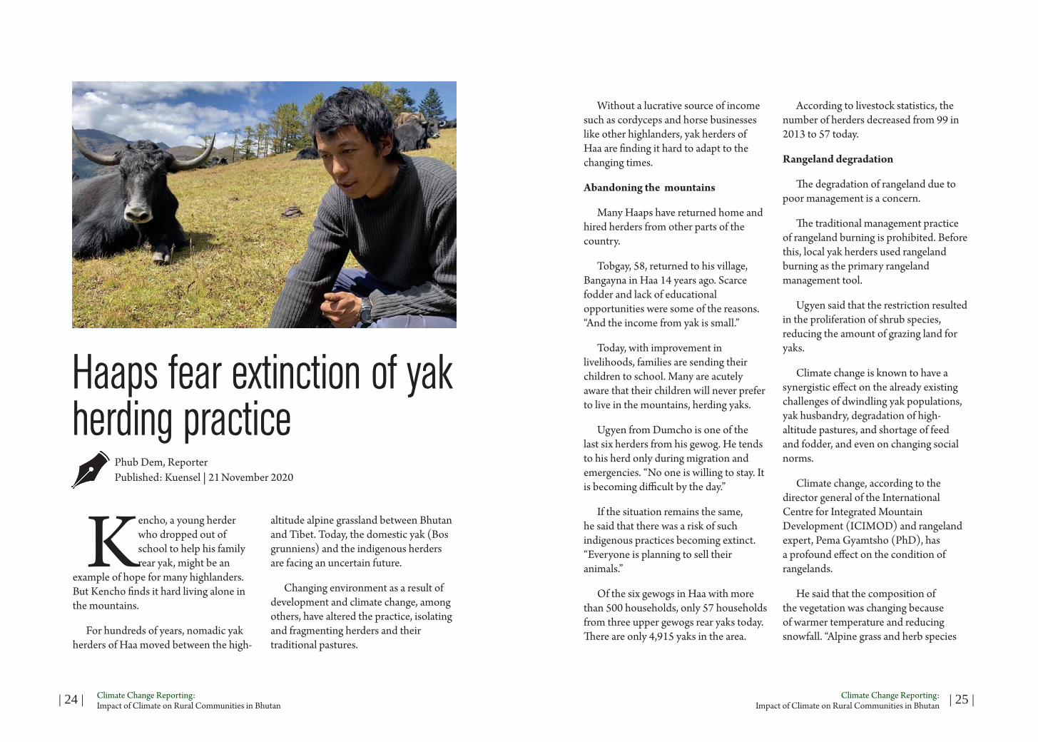
Kencho, a young herder who dropped out of school to help his family rear yak, might be an
example of hope for many highlanders. But Kencho finds it hard living alone in the mountains.
For hundreds of years, nomadic yak herders of Haa moved between the high-
altitude alpine grassland between Bhutan and Tibet. Today, the domestic yak (Bos grunniens) and the indigenous herders are facing an uncertain future.
Changing environment as a result of development and climate change, among others, have altered the practice, isolating and fragmenting herders and their traditional pastures.
Without a lucrative source of income such as cordyceps and horse businesses like other highlanders, yak herders of Haa are finding it hard to adapt to the changing times.
Abandoning the mountains
Many Haaps have returned home and hired herders from other parts of the country.
Tobgay, 58, returned to his village, Bangayna in Haa 14 years ago. Scarce fodder and lack of educational opportunities were some of the reasons. “And the income from yak is small.”
Today, with improvement in livelihoods, families are sending their children to school. Many are acutely aware that their children will never prefer to live in the mountains, herding yaks.
Ugyen from Dumcho is one of the last six herders from his gewog. He tends to his herd only during migration and emergencies. “No one is willing to stay. It is becoming difficult by the day.”
If the situation remains the same, he said that there was a risk of such indigenous practices becoming extinct. “Everyone is planning to sell their animals.”
Of the six gewogs in Haa with more than 500 households, only 57 households from three upper gewogs rear yaks today. There are only 4,915 yaks in the area.
According to livestock statistics, the number of herders decreased from 99 in 2013 to 57 today.
Rangeland degradation
The degradation of rangeland due to poor management is a concern.
The traditional management practice of rangeland burning is prohibited. Before this, local yak herders used rangeland burning as the primary rangeland management tool.
Ugyen said that the restriction resulted in the proliferation of shrub species, reducing the amount of grazing land for yaks.
Climate change is known to have a synergistic effect on the already existing challenges of dwindling yak populations, yak husbandry, degradation of high-altitude pastures, and shortage of feed and fodder, and even on changing social norms.
Climate change, according to the director general of the International Centre for Integrated Mountain Development (ICIMOD) and rangeland expert, Pema Gyamtsho (PhD), has a profound effect on the condition of rangelands.
He said that the composition of the vegetation was changing because of warmer temperature and reducing snowfall. “Alpine grass and herb species

| 26 | Climate Change Reporting: Impact of Climate on Rural Communities in Bhutan | 27 |Climate Change Reporting:
Impact of Climate on Rural Communities in Bhutan
are being replaced by invasive species of shrubs and weeds from lower areas.”
The receding of the snow line, he said, exposes the alpine screes to erosions and landslides. “Increasing rainfall replacing snowfall is further leading to degradation of the rangeland through increased erosion.”
The country is also experiencing increasing temperatures, leading to a significant change in tradition of herding yaks.
A finding from the analysis of historical climate between 1996 to 2017 by the National Center for Hydrology and Meteorology indicated increase in temperature both at mean seasonal and annual scales. The overall trends in rainfall showed a more considerable variability and decrease in rainfall.
Two decades ago, although the facilities were limited, there never was shortage of natural resources, according to herder Ugyen. “Around 20 households would be herding more than 500 yaks in the same grassland. Today, although there are only four herders with less than 300 yaks, there is a shortage of winter fodder.”
The herders have also observed the proliferation of warm-climate plants like the rhododendron and other lowland trees encroaching upon pastures where yaks graze.
Sonam Dorji, a herder from Hatey, said it was challenging to find fodder in places where it used to be abundant.
According to a report “Yak on the Move” by the ICIMOD, shortages of winter fodder, a decline in the number of yaks as well as young herders, restrictions on mobility and exchange, and climate change are some of the challenges shared by the herders of Himalayan Hindu Kush region. It states that climate change is known to have a significant impact on species distribution and diversity patterns. “Warming temperatures in the high elevation region can harm yak populations because of their lack of tolerance for heat, the reduction in habitat, and decline in yak survival and reproduction.”
With experts predicting a severe impact of warming temperature on mountain natives, Sonam Jamtsho from Yangthang said there was no choice but to abandon the practice. His yak population has doubled over the years. Shortage of fodder, especially during winter, is a concern.
As Sonam’s herd resides right next to the China border, he said that he could not migrate further due to border restrictions. According to studies conducted in different parts of the Himalayan region, climate change is forcing communities to migrate to higher elevations in search of productive grazing lands, with an early start in the upward migration due to shortening of the winter period.
He said that the only solution was for the government to lease tsamdro to the yak herders before it is too late. The
Land Act (2007) nationalised rangelands through a generous compensation scheme.
Grazing allotments under a leasehold system are yet to be implemented.
To address the fodder scarcity in winter, the herders buy supplementary feeds such as Karma Feed and locally available feeds likebuckwheat flour, mustard oil cake and barley grains, among others.
Drying up of spring and high-altitude wetland
The highlanders of Haa have witnessed a considerable decrease in snowfall in the last couple of years.
Springs and high-altitude wetland, one of the significant sources of water are reportedly depleting. Such incidences are increasing by the day, especially during the long dry season, posing a threat to people’s livelihood and the rural economy.
Ugyen said that he had to walk for hours to reach the drinking water source. “In winter, I melt snow to cook and drink.”
A study published by Mountain Research and Development titled “Signs of climate change through the eyes of yak herders in northern Bhutan”, reveals an increase in temperature, glacial retreat, and ascension of the snow line.
Major yak herding communities were selected from the districts of Thimphu,
Bumthang, Paro, and Wangdue to evaluate the vulnerabilities of yak herding communities.
Herders noted that weather events such as flash flood have become increasingly unpredictable and severe. Many also said that water sources are drying gradually and water availability has dwindled.
Activities under highland development programme
The National Highland Development Centre focuses on interventions related to livestock in the highlands after the government flagged off the highland flagship programme.
The receding of the snow line, he said, exposes the alpine screes to erosions and landslides. “Increasing rainfall replacing snowfall is further leading to degradation of the rangeland through increased erosion.”
| 28 | Climate Change Reporting: Impact of Climate on Rural Communities in Bhutan | 29 |Climate Change Reporting:
Impact of Climate on Rural Communities in Bhutan
The initiatives to enhance the highlanders’ livelihood include making groups and cooperatives, product diversification, disease control, and improving the high-altitude rangeland.
Chief livestock officer with the research and extension division, Tawchu Rabgay, said that the programme targets enhancing the livelihood prospects of the highlanders based on income-generating opportunities from yak rearing.
He said that the programme includes value-adding and branding yak products from across the dzongkhags to target both the regional and international market. “For a consistent supply chain, we are focusing on yak groups and cooperatives.”
Improvement of nutrition for the yaks, elimination of GID and measures to prevent and control the zoonotic disease are some of the initiatives under the programme. The programme has plans to set up a processing unit in every yak rearing dzongkhag.
With more than five yak herders cooperatives, a national-level federation of yak herders would also be developed under the programme.
The yak federation, according to Tawchu Rabgay, would be an apex body to preserve, promote and protect yaks in the highlands. “A larger group at the national level will address the issue of supplying products for commercial enterprises, enable farmers to collaborate and integrate with regional highlanders.”
Meanwhile, the Yak Breeding Centre in Haa will also initiate the use of artificial insemination to promote good breeding practice in yaks. Due to inbreeding practice, he said that a lot of dilution in the yak breeds was happening. “We also want to start processing yak semen so that we can conserve and upgrade the genetic material of our yaks. ”
In an attempt to improve the degrading rangeland, the centre is currently studying the nature of the grass and is planning to propagate the existing grass, as it was not viable to introduce new grass species.
Tawchu Rabgay also said that the centre was in the process of introducing a feed block which would be taken up by the cooperatives and distributed to the highlanders.
The National Land Commission, he said, was in the process of returning the tsamdro to the genuine yak herders as per their user right thrams.
In the meantime, most herders are of the view that with government changing after every election cycle, different policies come up and this does not help solve the problem.
Many said that although the government provided them with tarpaulin, woodstove, milking and churning equipment, little could they be put to use.
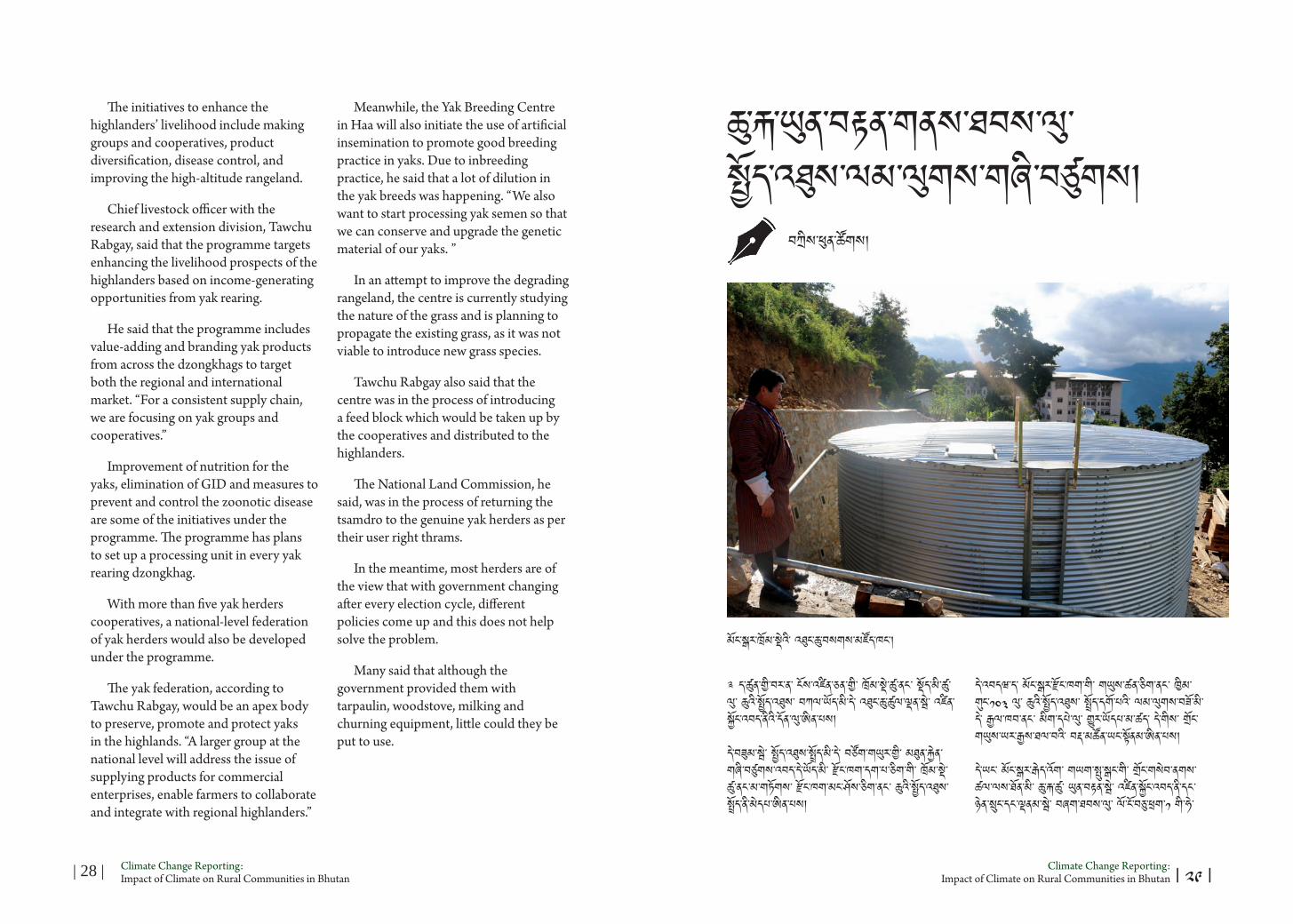
༉ ད་ཚུན་གྱི་བར་ན་ ངོས་འཛིན་ཅན་གྱི་ ཁྲོམ་སྡེ་ཚུ་ནང་ སྡོད་མི་ཚུ་ལུ་ ཆུའི་སྤྱོད་འཐུས་ བཀལ་ཡོད་མི་དེ་ འཐུང་ཆུ་ཚུལ་ལྡན་སྦེ་ འཛིན་སྐྱོང་འབད་ནིའི་དོན་ལུ་ཨིན་པས།
དེ་བཟུམ་སྦེ་ སྤྱོད་འཐུས་སྤྲོད་མི་དེ་ བཙོག་གཡུར་གྱི་ མཐུན་རྐྱེན་གཞི་བཙུགས་འབད་དེ་ཡོད་མི་ རྫོང་ཁག་དག་པ་ཅིག་གི་ ཁྲོམ་སྡེ་ཚུ་ནང་མ་གཏོགས་ རྫོང་ཁག་མང་ཤོས་ཅིག་ནང་ ཆུའི་སྤྱོད་འཐུས་ སྤྲོད་ནི་མེདཔ་ཨིན་པས།
ཆུ་རྐ་ཡུན་བརྟན་གནས་ཐབས་ལུ་ སྤྱོད་འཐུས་ལམ་ལུགས་གཞི་བཙུགས།
དེ་འབདཝ་ད་ མོང་སྒར་རྫོང་ཁག་གི་ གཡུས་ཚན་ཅིག་ནང་ ཁྱིམ་གུང་༡༠༣ ལུ་ ཆུའི་སྤྱོད་འཐུས་ སྤྲོད་དགོ་པའི་ ལམ་ལུགས་བཟོ་མི་དེ་ རྒྱལ་ཁབ་ནང་ མིག་དཔེ་ལུ་ གྱུར་ཡོདཔ་མ་ཚད་ དེ་གིས་ གྲོང་གཡུས་ཡར་རྒྱས་ཐལ་བའི་ བརྡ་མཚོན་ཡང་སྟོནམ་ཨིན་པས།
དེ་ཡང་ མོང་སྒར་རྒེད་འོག་ གཡག་སྤུ་སྒང་གི་ གྲོང་གསེབ་ནགས་ཚལ་ལས་ཐོན་མི་ ཆུ་རྐ་ཚུ་ ཡུན་བརྟན་སྦེ་ འཛིན་སྐྱོང་འབད་ནི་དང་ ཉེན་སྲུང་དང་ལྡནམ་སྦེ་ བཞག་ཐབས་ལུ་ ལོ་ངོ་བཅུ་ཕྲག་༡ གི་ཧེ་
བཀྲིས་ཕུན་ཚོགས།
མོང་སྒར་ཁྲོམ་སྡེའི་ འཐུང་ཆུ་བསགས་མཛོད་ཁང་།
| ༢༩ |

| 30 | Climate Change Reporting: Impact of Climate on Rural Communities in Bhutan | 31 |Climate Change Reporting:
Impact of Climate on Rural Communities in Bhutan
མར་ མཐའ་འཁོར་གནས་སྟངས་ཀྱི་ ཞབས་ཏོག་སྤྱོད་འཐུས་ལས་འཆར་གཞི་བཙུགས་འབད་ནུག།
གྲོང་གསེབ་ནགས་ཚལ་ལས་ཐོན་མི་ རོང་ཆུ་དེ་ མོང་སྒར་ཁྲོམ་དང་ ལུང་ཕྱོགས་གཙོ་བསྟེན་སྨན་ཁང་ ཝེང་མཁར་གཡག་སྤུ་སྒང་སྤྱི་འོག་དང་ སྐྱིད་བདེ་མཁར་སྤྱི་འོག་ བཤད་གྲྭ་ དེ་ལས་ སློབ་གྲྭ་ཚུ་གིས་ ལག་ལེན་འཐབ་སྟེ་ ལོ་ངོ་བཅུ་ཕྲག་༢ ལྷག་ཡོདཔ་ད་ སྤྱི་ལོ་༢༠༡༠ ལུ་ སོ་ནམ་དང་ནགས་ཚལ་ལྷན་ཁག་ ཆུ་འབབ་ས་གནས་འཛིན་སྐྱོང་སྡེ་ཚན་དང་ མོང་སྒར་ལུང་ཕྱོགས་ནགས་ཚལ་ལས་ཚན་༢ མཉམ་རུབ་ཐོག་ལས་ སྤྱོད་འཐུས་ལས་འཆར་འགོ་བཙུགས་ནུག།
ལས་འཆར་དེ་ཡང་ གནམ་གཤིས་འགྱུར་བགྲོད་ལུ་བརྟེན་ ལོ་བསྟར་བཞིན་དུ་ ཆུ་རྐ་སྐམ་ནི་དང་ ས་རུད་དང་ ཆུ་རུད་འཐོན་ནི་ མཐའ་འཁོར་གནས་སྟངས་ཉམས་ཉེན་བཀག་ཐོག་ལས་ ཆུ་རྐ་ཚུ་ མ་འོངས་ཡུན་བརྟན་དང་ ཉེན་སྲུང་དང་ལྡནམ་སྦེ་ བཞག་ཐབས་ལུ་ཨིན་པས།
ཆུ་དེ་གིས་ གཡག་སྤུ་གང་དང་ སྐྱིད་བདེ་མཁར་གཡུས་ཚན་གྱི་ ཁྱིམ་གུང་༡༠༣ དང་ མོང་སྒར་ཁྲོམ་སྡེའི་ ཁྱིམ་གུང་པ་༡,༠༢༠ དེ་ལས་ ལུང་ཕྱོགས་གཙོ་བསྟེན་སྨན་ཁང་གི་ ལས་བྱེདཔ་དང་ ནདཔ་ཚུ་ལུ་ ཕན་ཐོགས་བྱུངམ་ཨིན་པས།
ནགས་ཚལ་དང་གླིང་ཀ་ཞབས་ཏོག་ལས་ཁུངས་ལས་ ཆུ་འབབ་ས་གནས་འཛིན་སྐྱོང་སྡེ་ཚན་གྱི་ ནགས་ཚལ་གཙོ་འཛིན་འགོ་དཔོན་ སྲི་རྒྱལ་སྒྲོལ་མ་གིས་ སླབ་མིའི་ནང་ སྤྱོད་འཐུས་ལས་འཆར་དེ་ རྒྱལ་ཁབ་ནང་ དཔེ་སྟོན་བཟང་པོ་ཅིག་ལུ་ གྱུར་ཡོདཔ་བཞིན་དུ་ གཞན་རྫོང་ཁག་ རྩི་རང་དང་ ཆུ་ཁ་ དེ་ལས་ སྤ་རོ་ཚུ་གིས་ཡང་ ལས་འཆར་འགོ་བཙུགས་ཏེ་ཡོད་ཟེར་ཨིན་པས།
མོང་སྒར་གྱི་རྒཔོ་ བསྟན་འཛིན་དབང་ཕྱུག་གིས་ སླབ་མིའི་ནང་ ལམ་ལུགས་དེ་ལུ་བརྟེན་ ས་གནས་ཀྱི་ གྲོང་གསེབ་མི་སེར་ཚུ་ལུ་ མ་དངུལ་གྱི་ ཁེ་ཕན་དང་ མ་འོངས་ཡུན་བརྟན་སྦེ་ མཐའ་འཁོར་གནས་སྟངས་ཉམས་སྲུང་འབད་ནི་ལུ་ ལྷན་ཐབས་འབད་དེ་ཡོད་ཟེར་ཨིན་པས།
མོང་སྒར་དེ་ ཤར་ཕྱོགས་རྫོང་ཁག་༦ གི་ ཁྲོམ་སྡེ་ལྟེ་བ་ཅིག་ཨིནམ་ལས་ ལོ་བསྟར་བཞིན་དུ་ ཁྲོམ་སྡེ་གོང་འཕེལ་འགྱོཝ་དང་གཅིག་ཁར་ སློབ་གྲྭ་དང་ ལུང་ཕྱོགས་ཡིག་ཚང་ཚུ་ གཞི་བཙུགས་དོ་ཡོདཔ་ལས་ ཆུ་རྐ་བདག་འཛིན་འབད་ནིའི་ ལས་རིམ་ལུ་ རྒེད་འོག་བདག་སྐྱོང་གིས་ཡང་ གཙོ་རིམ་བཟུང་དོ་ཟེར་ རྒཔོ་གིས་ བཤདཔ་ཨིན་པས།
གཡག་སྤུ་སྒང་གྲོང་སྡེ་ནགས་ཚལ་གྱི་ཁྲི་འཛིན་ སངས་རྒྱས་རྡོ་རྗེ་གིས་ སླབ་མིའི་ནང་ ཆུ་འབབ་ས་གནས་འཛིན་སྐྱོང་སྡེ་ཚན་གྱིས་ ཚན་རིག་བརྟག་དཔྱད་དང་འཁྲིལཝ་ད་ ཆུ་དེ་ གཙང་སྦྲ་དང་ལྡན་པའི་ཁར་ གཡུས་མི་གིས་ཚུ་ཡང་ མཐའ་འཁོར་གནས་སྟངས་ བདག་འཛིན་འབད་ནི་ལུ་ རྒྱབ་སྐྱོར་འབད་དེ་ཡོད་ཟེར་ཨིན་པས།
མོང་སྒར་ལུང་ཕྱོགས་གཙོ་བསྟེན་སྨན་ཁང་གི་ བདག་སྐྱོང་གཙོ་འཛིན་འགོ་དཔོན་འོགམ་ ཀརྨ་ ཡེ་ཤེས་ཀྱིས་ སྨན་ཁང་ནང་འཐེན་མི་ཆུ་རྐ་དེ་ གཡག་སྤུ་སྒང་གྲོང་སྡེ་ནགས་ཚལ་ནང་ ཚུད་ཡོདཔ་ལས་ སྤྱོད་འཐུས་ལས་འཆར་ནང་ བཅའ་མར་མ་གཏོགས་པ་ཅིན་ མ་འོངས་པ་ལུ་ འཐུང་ཆུ་མི་འཐོབ་ནིའི་ཉེན་ཁ་འདུག་ཟེར་ བཤདཔ་ཨིན་པས།
རྫོང་ཁག་ཁྲོམ་སྡེའི་བཟོ་རིག་འགོ་དཔོན་ རམ་བྷ་དུར་དར་རྒྱས་ཀྱིས་ སླབ་མིའི་ནང་ རྫོང་ཁག་བདག་སྐྱོང་དང་ སློབ་གྲྭ་ ལུང་ཕྱོགས་ཁག་གི་ཡིག་ཚང་ ཚོང་པ་ དེ་ལས་ ཁྲོམ་གྱི་ཁྱིམ་གུང་༡,༠༠༠ ལྷགཔ་ཅིག་གིས་ དུས་ཡུན་ཆུ་ཚོད་༢༤ གི་རིང་ འཐུང་ཆུ་སྤྱོད་མི་དེ་ལུ་ འཐུས་སྤྲོད་དོ་ཟེར་ཨིན་པས།
གཡག་སྤུ་སྒང་ལས་འཐེན་མི་ ཆུ་རྐ་ལས་ ཆུ་ལང་མ་ཚུགས་ནི་དེ་གིས་ ཀོ་རི་ལ་དང་ སྒང་གུ་ལ་ གཡག་སྒང་ལུ་ ངོས་འཛིན་འབད་མི་ ཆུ་རྐ་༩ ལས་འཐེན་ཏེ་ བཀའ་དམ་ལུ་ ཆུ་བཙག་མཛོད་ཁང་ནང་ བསགས་ཞིནམ་ལས་ གཙང་སྦྲ་དང་ལྡནམ་སྦེ་ མི་མང་ལུ་ བཀྲམ་སྤེལ་འབད་དོ་ཟེར་ཨིན་པས།
མོང་སྒར་ཁྲོམ་ཁར་ ཉིན་བསྟར་བཞིན་དུ་ ཆུ་ལི་ཊར་ས་ཡ་༡.༥ དགོས་མཁོ་ཡོདཔ་ད་ འདས་པའི་ལོ་དག་པ་ཅིག་ལས་ ཆུ་བཀྲམ་སྤེལ་གྱི་ཞབས་ཏོག་ ཡར་དྲག་སོང་ཡི་ཟེར་ འགོ་དཔོན་གྱིས་ བཤདཔ་ཨིན་པས།
ཁྲོམ་སྡེའི་འཐུས་མི་ངོ་ཚབ་ རྣམ་རྒྱལ་རྡོ་རྗེ་གིས་ སླབ་མིའི་ནང་ ཧེ་མ་འབད་བ་ཅིན་ ཁྲོམ་ནང་ མི་རློབས་ཉུངམ་སྦེ་ཡོདཔ་ལས་ ན་གླིང་གུ་ལས་འཐོན་མི་ ཆུ་རྐ་ལག་ལེན་འཐབ་ནུག་ཟེར་ཨིན་པས།
ཨིན་རུང་ ཁྲོམ་ནང་ བཟོ་སྐྲུན་གོང་འཕེལ་གྱི་ལས་སྣ་ཚུ་ རིམ་གྱིས་གོང་འཕེལ་འགྱོ་མི་ལུ་བརྟེན་ འཐུང་ཆུ་ལང་མ་ཚུགསཔ་ལས་ གཡག་སྤུ་གང་གི་ ཆུ་དེ་ སྤྱོད་ནི་འགོ་བཙུགས་ཡི་ཟེར་ཨིན་པས།
ལས་འཆར་ལས་ལུགས།
སྤྱོད་འཐུས་དེ་ སྤྱི་ལོ་༢༠༡༠ ལུ་ ལོ་༣ གྱི་དོན་ལས་ མོ་བཏབ་བཟུམ་སྦེ་ གཞི་བཙུགས་འབདཝ་ད་ ལོ་རེ་ལུ་ དངུལ་ཀྲམ་༥༢,༠༠༠ དང་ ཐེངས་༢ པའི་སྐབས་ ལོ་༥ འི་རིང་ ལོ་རེ་ལུ་
དངུལ་ཀྲམ་༡༤༨,༢༠༠ བསྡུ་ལེན་འབད་ཡོདཔ་བཞིན་དུ་ སྤྱི་ལོ་༢༠༢༠-༢༠༢༩ ཚུན་ སྤྱོད་འཐུས་ཡར་སེང་ཐོག་ ལོ་བསྟར་བཞིན་དུ་ དངུལ་ཀྲམ་༢༢༨,༢༠༠ རེ་སྤྲོད་དགོཔ་སྦེ་བཟོ་ནུག།
དུས་ཅི་ མི་སྡེ་དང་ ཞབས་ཏོག་སྤྱོད་མི་ མོང་སྒར་ཁྲོམ་སྡེ་དང་ ལུང་ཕྱོགས་གཙོ་བསྟེན་སྨན་ཁང་ ལུང་ཕྱོགས་ནགས་ཚལ་ལས་ཚན་ རྫོང་ཁག་བདག་སྐྱོང་ དེ་ལས་ ཆུ་འབབ་ས་གནས་འཛིན་སྐྱོང་སྡེ་ཚན་གྱི་ འགོ་དཔོན་ཚུ་གི་བར་ན་ དུས་ཡུན་བསྐྱར་གསོའི་ གྲོས་བསྟུན་ཞལ་འཛོམས་འཚོགས་ཏེ་ སྤྱོད་འཐུས་ཚུ་ ལོ་ངོ་༡༠ གྱི་རིང་ ཡར་སེང་འབད་ནུག།
མི་སྡེ་གྲོང་གསེབ་ནགས་ཚལ་སྦེ་ ངོས་འཛིན་འབད་མི་ ས་ཆ་ཨེ་ཀར་༩༢༤ ནང་ ཆུ་རྐ་༣ ངོས་འཛིན་འབད་ཡོདཔ་ལས་ ཆུ་འབབ་ས་གནས་འཛིན་སྐྱོང་ལས་སྡེ་གིས་ ས་ཆ་ཨེ་ཀར་༦༣༨ དེ་ཅིག་ སྲུང་སྐྱོབ་ས་ཁོངས་སྦེ་ ངོས་འཛིན་འབད་ནུག།
མཐའ་འཁོར་གནས་སྟངས་མར་ཉམས་འགྱོ་མི་ཚུ་ནང་ ཤིང་འཛུགས་སྐྱོང་དང་ ནགས་ཚལ་གྱི་ ཐོན་སྐྱེད་ཚུ་ ཁྲིམས་འགལ་ཐོག་ ཕྱིར་བཏོན་འབད་མ་བཅུག་པར་ ཉེན་སྲུང་འབད་ནི་ ཆུ་རྐའི་མཐའམ་བདའ་སྟེ་ རག་རོ་སེལ་ནི་དང་ ཚལ་མ་བརྫམ་ནི་ དེ་ལས་ ཆུ་རྐའི་ས་ཁོངས་ནང་ ཉི་མར་ནོར་ཚུ་ རྩྭ་ཟ་བར་བདའ་ཆོག་རུང་ ཕྱི་རུ་བཞག་མ་ཆོགཔ་མ་ཚད་ ཁྱིམ་གུང་རེ་གིས་ ནོར་༥ ལས་བརྒལ་ གསོ་མ་ཆོགཔ་སྦེ་ ཞབས་ཏོག་བྱིན་མི་དང་ སྤྱོད་མི་༢ ལུ་ འགན་འཁྲི་བཀལ་ནུག།
ལས་རིམ་དེ་ཡང་ རྒྱལ་སྤྱི་མཐའ་འཁོར་གནས་སྟངས་ཉམས་སྲུང་མཐུན་རྐྱེན་ལས་ གོང་འཕེལ་མ་འགྱོ་བའི་རྒྱལ་ཁབ་མ་དངུལ་འོག་གི་ ན་པ་ལས་འགུལ་ཐོག་ལས་ གཞི་བཙུགས་འབད་ཡོདཔ་ཨིན་པས།
ཆུ་སྲུང་པ་ སྐྱེས་ལོ་༢༨ ལང་མི་ བསོད་ནམས་རྒྱལ་མཚན་གྱིས་ སླབ་མིའི་ནང་ ཟླཝ་༣ གྱི་རྒྱབ་ལས་ འཐུས་མི་ག་ར་ ཆུ་རྐ་ཚུན་ རག་རོ་སེལ་བར་ འོང་དགོཔ་བཞིན་དུ་ ལོ་༡ ནང་ ཚར་༤ ལཱ་འབད་དགོཔ་མ་ཚད་ ཆུའི་མཐའམ་བདའ་སྟེ་ ཤིང་བཏོག་ཡོད་མེད་དང་ ནོར་སེམས་ཅན་ཡོད་མེད་བལྟ་ནི་ དེ་ལས་ རང་བཞིན་གནས་སྟངས་ལུ་ ཐོ་ཕོག་ཡོད་མེད་ ཞིབ་དཔྱད་འབད་དགོ་ཟེར་ཨིན་པས།
གནམ་དགུན་ལུ་ ཆུ་མི་ཊར་༡༠ ལས་༥ ལུ་ མར་འབབ་འགྱོཝ་ད་ ཁྲོམ་སྡེ་དང་ ལུང་ཕྱོགས་གཙོ་བསྟེན་སྨན་ཁང་ནང་ ཆུ་ལང་མ་ཚུགསཔ་ འགྱོཝ་ཨིན་པས།
མོང་སྒར་ཁྲོམ་སྡེའི་དོན་ལུ་ ལན་ཤིང་ཤོང་དང་ ཤིང་ནང་ཟམ་པ་ཆུ་རྐ་༢ ལས་དང་ ལུང་ཕྱོགས་གཙོ་བསྟན་སྨན་ཁང་ལུ་ ཆང་ཤི་ཝང་དང་ ཤེས་གྲུབ་ཆོས་གླིང་ལྷ་ཁང་ལས་བབས་མི་ ཆུ་༢ ལག་ལེན་འཐབ་ཨིན་པས།
གྲོང་སྡེ་ནགས་ཚལ་གྱི་དྲུང་ཆེན་ ཤེས་རབ་བསྟན་འཛིན་གྱིས་ ཁྲོམ་སྡེ་དང་ ལུང་ཕྱོགས་གཙོ་བསྟེན་སྨན་ཁང་ལས་ཐོབ་མི་ སྤྱོད་འཐུས་དེ་ འཐུས་མི་༡༠༣ ཡོད་མི་ གྲོང་སྡེ་ནགས་ཚལ་ཚོགས་པའི་ མིང་ཐོ་གུ་ གསོག་འཇོག་འབད་དོ་ཟེར་བཤདཔ་ཨིན་པས།
ཚོགས་པའི་རྩིས་འཛིན་པ་ བསོད་ནམས་བཟང་པོ་གིས་ སླབ་མིའི་ནང་ ལོ་༡༠ ནང་འཁོད་ སྤྱོད་འཐུས་དངུལ་ཀྲམ་༧༡༤,༤༠༠ ལྷགཔ་ཅིག་ ཚོགས་པའི་རྩིས་ཁྲ་ནང་ བཙུགས་མི་དེ་ འཐུས་མི་ཚུ་ལུ་ ནཝ་ཚཝ་དང་ མི་ལུ་ ཤི་རྐྱེན་བྱུངམ་ད་ རྒུས་འཐུས་སྦེ་ དངུལ་ཀྲམ་༣,༠༠༠ རེ་བྱིན་ནི་ ཡོདཔ་མ་ཚད་ ཉམ་ཆུང་ཚུ་ལུ་ ཆ་རོགས་འབད་དོ་ཟེར་ཨིན་པས།
ད་རེས་ཀྱི་ ལས་འཆར་ནང་ ཆུ་རྐ་༣ ཡུན་བརྟན་སྦེ་གནས་ཐབས་ལུ་ ཞབས་ཏོག་སྤྱོད་ཆོག་པའི་ས་ཁོངས་དང་ བར་གླིང་ དེ་ལས་ བསྐྱར་གསོ་ས་ཁོངས་སྦེ་ ངོས་འཛིན་འབད་དེ་ཡོདཔ་བཞིན་དུ་ མ་འོངས་ཡུན་བརྟན་ལུ་ ས་རུད་དང་ ཆུ་རུད་འཐོན་མ་བཅུག་པར་ ལེགས་ཤོམ་སྦེ་ བདག་འཛིན་འཐབ་སྟེ་ ཤིང་འཛུགས་སྐྱོང་དང་ བྱ་སྒོའི་ལམ་ལུགས་སྒྲིང་སྒྲི་སྦེ་ བསྟར་སྤྱོད་འབད་དོ་ཡོདཔ་ཨིན་པས།
གདོང་ལེན།
མོང་སྒར་ཁྲོམ་སྡེ་དང་ གཙོ་བསྟེན་སྨན་ཁང་ནང་འཐེན་མི་ ཆུ་རྐའི་ལྟག་ལུ་ ཁྱིམ་གུང་༤ ཡོདཔ་ལས་ ཆུ་གཙང་སྦྲ་དང་ལྡནམ་མེད་པའི་ཁར་ ས་རུད་དང་ ཆུ་རུད་ཀྱིས་ ཆུ་རྐ་ལུ་ གནོད་སྐྱོན་རྐྱབ་དོ་ཡོདཔ་ལས་ ད་རེས་ ཆུ་བཙག་མཛོད་ལས་ མི་ཊར་༢༠༠ དེ་ཅིག་གི་ས་ཁར་ སྤོ་བཤུད་འབད་དགོཔ་ཡོད་ཟེར་ཨིན་པས།
གྲོང་སྡེ་ནགས་ཚལ་ལས་ ཁེ་ཕན་སྤྱོད་མི་ཚུ་ལུ་ ཐབ་ཤིང་དང་ དར་ཤིང་ ལྷ་ཁང་ སྒོ་ཤིང་ཚུ་ བྱིན་ནི་ཨིན་རུང་ བཟོ་ཤིང་དང་ དྲྭ་ཤིང་ ཐབ་ཤིང་ཚུ་ ལང་མ་ཚུགས་པའི་ དཀའ་ངལ་ཡོདཔ་ལས་ གཞུང་དབང་ནགས་ཚལ་ལས་ ཐོབ་ཐབས་ཀྱི་ ཞུ་བ་འབད་དགོཔ་ཐོན་ནུག།
ཁྲོམ་ནང་སྡོད་མི་བརྒྱ་ཆ་༦༠ ལུ་ ཆུ་བསགས་བཞག་ནིའི་གྱིབ་མཛོད་ ཡང་ཅིན་ དགོས་མཁོ་ཅན་གྱི་ ཅ་ཆས་ཚུ་མེད་པའི་ དཀའ་ངལ་ཡོདཔ་ལས་ སྒྲིང་ཁྱིམ་གྱི་ཇོ་བདག་དང་ ཁང་གླ་ཁར་སྡོད་མི་ཚུ་གིས་ཡང་ འགན་ཁུར་འདྲ་མཉམ་སྦེ་ འབག་དགོཔ་འདུག་ཟེར་ ཁྲོམ་སྡེའི་འགོ་དཔོན་ཚུ་གིས་ བཤདཔ་ཨིན་པས།

| 32 | Climate Change Reporting: Impact of Climate on Rural Communities in Bhutan | 33 |Climate Change Reporting:
Impact of Climate on Rural Communities in Bhutan
ལས་འཆར་དེ་གིས་སྦེ་ མི་སྡེ་དང་ འཐུང་ཆུ་སྤྱོད་མི་༢ ཆ་ར་ལུ་ ཁེ་ཕན་བྱུང་ཡོད་རུང་ ནང་འཁོད་ལས་ མཉམ་འབྲེལ་ཐོག་ ལཱ་འགན་འབག་མ་བཏུབ་པའི་དཀའ་ངལ་དང་ འཕྲལ་འཕྲལ་ར་ རྫོང་ཁག་དང་ ས་གནས་གཞུང་གི་ འབྲེལ་ཡོད་འགོ་དཔོན་ཚུ་ གནས་སོར་དང་ འགོ་ཁྲིདཔ་གསརཔ་འོང་པའི་སྐབས་ བྱ་སྒོའི་ལམ་ལུགས་དང་འཁྲིལ་ བསྟར་སྤྱོད་འབད་མ་ཚུགས་པའི་ གདོང་ལེན་ཡོདཔ་ཨིན་པས།
ཆུ་རྐ་འཛིན་སྐྱོང་།
དུས་ཅི་ སྤྱི་ཟླ་༩ པའི་ཚེས་༡༢ ལུ་ མི་དབང་མངའ་བདག་རིན་པོ་ཆེ་མཆོག་གིས་ རྒྱལ་ཡོངས་ལུ་ རྒྱང་མཐོང་ཐོག་ལས་ གསུང་བཤད་གནངམ་ད་ འཛམ་གླིང་རྒྱལ་ཁབ་ཚུ་གི་གྲས་ལས་ ཆུ་འབོལ་ཤོས་ར་ འབྲུག་ལུ་ཡོད་རུང་ ཁག་ཆེ་ས་ནང་ ཆུ་མ་ལངམ་ལས་ མི་ཚུ་ ལཱ་འབད་དགོ་མནོ་རུང་ འབད་མ་ཚུགས་པར་ ལུས་མི་དང་ ས་ཆ་དགའ་ཏོག་ཏོ་ཡོད་མི་ མང་ཧད་རྫོགསཔ་ཅིག་ སྤྱོད་མ་ཚུགས་པར་ལུས་མི་དེ་ཡང་ ཆུ་མེད་པར་ཨིནམ་ལས་ རྒྱལ་ཁབ་ཀྱི་ཆུ་དེ་ བདག་འཛིན་འཐབ་དགོཔ་ གལ་ཆེ་བའི་སྐོར་གསུངས་ཡི།
འཐུང་ཆུ་བཀྲམ་སྤེལ་ཁྱད་རིག་སྦྱོང་བརྡར་ལས་རིམ་དང་འཁྲིལཝ་ད་ སོ་ནམ་གྱི་དོན་ལུ་ ཆུ་ལག་ལེན་འཐབ་མི་དེ་ བརྒྱ་ཆ་༦༩ དང་ བཟོ་གྲྭ་འཕྲུལ་ཁང་ནང་ བརྒྱ་ཆ་༡༩ དེ་ལས་ མི་སེར་ཚུ་གིས་ སྤྱོད་མི་དེ་ བརྒྱ་ཆ་༡༢ འདུག་ཟེར་ཨིན་པས།
བློན་ཆེན་ཌོག་ཊར་ བློ་གྲོས་ཚེ་རིང་གིས་ ཆུ་དེ་ཁག་ཆེཝ་ལས་ གཞུང་གིས་ ཁས་བླངས་འབད་ཡོདཔ་བཞིན་དུ་ དམིགས་བསལ་གྱི་ ལས་རིམ་༩ ཡོད་མི་ལས་༡ ཆུའི་དམིགས་བསལ་ལས་རིམ་ཨིན་ཟེར་ གསུངས་ཡོདཔ་ད་ འཐུང་ཆུ་དང་ ཞིང་ཆུ་ཚུ་ ཨ་རྟག་གི་ སྒྲིག་གཞི་གུ་བཀོད་དེ་ བཞག་ནི་མེན་པར་ ཚ་ངེར་བཏོན་ཏེ་ འབད་ནི་གི་ ལས་རིམ་ཚུ་ སྒྲིག་དོ་ཟེར་ཨིན་པས།
རྒྱལ་ཁབ་ནང་ ཆུ་དེ་ཁག་ཆེཝ་ལས་ གཞུང་གིས་ ཁས་བླངས་འབད་ཡོདཔ་བཞིན་དུ་ དམིགས་བསལ་གྱི་ ལས་རིམ་༩ ཡོད་མི་ལས་༡ ཆུའི་དམིགས་བསལ་ལས་རིམ་ཨིནམ་ད་ འཐུང་ཆུ་དང་ ཞིང་ཆུ་ཚུ་ ཨ་རྟག་གི་ སྒྲིག་གཞི་གུ་བཀོད་དེ་ བཞག་ནི་མེན་པར་ ཚ་ངེར་བཏོན་ཏེ་ འབད་ནི་གི་ ལས་རིམ་ཚུ་ སྒྲིག་དོ་ཟེར་ བློན་ཆེན་གྱིས་ གསུངསམ་ཨིན་པས།
མོང་སྒར་རྫོང་ཁག་ནང་ ད་ལྟོ་ཚུན་ ཆུ་རྐ་སྐམ་འགྱོ་མི་༡༠ དང་ ཆུ་རྐ་སྐམ་འགྱོ་བའི་བསྒང་ཡོད་མི་༡༧༩ དེ་ལས་ ཆུ་རྐ་༣༨༤ ཨ་རྟག་ག་ཨིནམ་ཡོདཔ་སྦེ་ འབྲུག་གི་ཆུ་འབབ་ས་ཁོངས་གནས་སྟངས་ནང་ བཀོད་ཡོདཔ་བཞིན་དུ་ རྫོང་ཁག་༢༠ གི་གྲས་ལས་ ཆུ་རྐ་སྐམ་མི་
མཐོ་ཤོས་ར་ བསམ་རྩེ་རྫོང་ཁག་ཨིནམ་ད་ དེ་ཡང་ ཆུ་རྐ་༢༥ དང་ དབང་འདུས་ཕོ་བྲང་ལུ་ ཆུ་རྐ་༢༣ དེ་ལས་ བཀྲིས་སྒང་ལུ་ ཆུ་རྐ་༢༠ སྐམ་ཡོདཔ་ཨིན་པས།
དེ་བཟུམ་སྦེ་ ཆུ་རྐ་སྐམ་པའི་བསྒང་ཡོད་མི་ཡང་ མཐོ་ཤོས་བསམ་རྩེ་ལུ་ཨིནམ་ད་ དེ་ཡང་ ཆུ་རྐ་༢༨༧ དང་ དབང་འདུས་ཕོ་བྲང་ལུ་ ཆུ་རྐ་༢༤༨ དེ་ལས་ བཀྲིས་སྒང་ལུ་ ཆུ་རྐ་༢༢༢ སྐམ་འགྱོ་དོ་ཡོད་པའི་གནས་ཚུལ།
གནས་ཚུལ་དེ་ འབྲུག་བརྡ་བརྒྱུད་གཞི་ཚོགས་ཀྱི་ མ་དངུལ་རྒྱབ་སྐྱོར་ཐོག་ལས་ བྲིས་སྤེལ་འབད་ཡོདཔ་ཨིན།
Conserving water resources with PES, an example from Yakpugang
Tashi Phuntsho, ReporterPublished: Kuensel | 17 November 2020
(ORIGINAL REPORTING IN DzONGKHA)
At a time when the issue of water shortage is growing in Bhutanese villages and towns, payment for environment services (PES) scheme has proved the right answer.
As yet, however, not all the dzongkhag have adopted the scheme.
In Yakpugang, Mongar the scheme is a major success story. Members of Yakpugang Community Forest (YCF) and the dzongkhag’s water user group have renewed PES agreement. The parties agreed to extend the contract term to 10 from five years and also revise the payment from Nu 30 to 50 per unit on the water meter a month for the

| 34 | Climate Change Reporting: Impact of Climate on Rural Communities in Bhutan | 35 |Climate Change Reporting:
Impact of Climate on Rural Communities in Bhutan
town. The rate remains the same for the Mongar Regional Referral Hospital.
The beauty of the scheme, which was first initiated in 2010, is that it incentivises the community forest members to protect the forest from excessive grazing and over-harvesting. Seen from the broader perspective, maintaining the watersheds upstream will result in good water yield and quality which will be beneficial to the hydropower stations downstream, irrigation and drinking water supply.
The idea is based on sharing the cost of conservation between the communities and the service users.
Service users/beneficiaries/buyers pay Nu 228,200 annually. During first two terms, they were provided an incentive of Nu 52, 000 and Nu 1, 48,200 respectively.
The protected area with a buffer zone in the watershed was identified as a recharge zone with the area of 638 acres surrounding the water source which covers more than half of the total CF area.
PES agreement was first signed between the Yakpugang CF and water user groups in 2011 for a period of three years. This was renewed in 2015 with a new term of five years that expired in December 2019.
The catchment area in Yakpugang CF is the main water source that caters for the residents in Mongar town and the
hospital staff. The CFM has 103 members from Yakpugang and upper Kidheykhar village. The CF covers an area of 650 acres.
Apart from protecting the recharge zone, the CFM members have to carry out certain regular activities like cleaning the stream, afforestation, guarding CF against illegal extraction of forest resources, limiting the number of cattle members, and maintaining sanitation and hygiene, among others.
Mongar Gup Tenzin Wangchuk said that with the scheme communities also benefited financially. It helped preserve their natural resources and educated the local people on how to protect the continuous flow of water from the sources.
The chairman of the community forest, Sangay Dorji, said that after establishing PES in the communities, officials from Watershed Management Division helped the locals with the system.
Mongar’s thromde engineer, Ram Bahadur Darjee, said that Mongar town had nine water sources, including the one at Yakpugang, seven km from town. There are 200 building owners in the town with 200 water meters in place. However, about 60 percent of the people living in the town do not have water tank or other storage facility which led to water shortage.
Mongar hospital’s deputy chief administrative officer, Karma Yeshi, said that the scheme ensured that there is enough water.
YCF has 103 members from Kedheykhar and Yakpugang. It has Nu 714,400 in its savings account. Sonam zangpo, accountant, said: “The money will enrich the community’s fund and will benefit in whatever ways the communities decide to use it. It could also lend and help the disadvantaged members of the community.”
Chief forestry officer, Sigyel Delma, said that the scheme was very effective. It has helped protect the water sources and, at the same time, service users can generate income.
The scheme functions according to an agreement signed between the service providers. The service providers carry out set of activities and service users pay for the activities after verifying the performance of the activities.
For example, the service providers of Yakpugang will maintain recharge zone of 638 acres. For that, the users will pay Nu 80,000 from Mongar Thromdey and Nu 20,000 from Mongar hospital. Service providers will also carry out plantation in the degraded area within the watershed, stop illegal extractions of forest resources, clear stream channels, limit grazing in the watershed area (communities shall be allowed to keep more than 5 cattle heads in the area). In total, service users in town will pay Nu 178, 200 and hospital Nu 50,000 annually.
“There is no specific study on the impact of climate change on water resources in the area, but we are experiencing more extreme weather
events, triggering landslides and other disasters if the watershed is not managed properly” Signal Delma said.
PES demarcates watershed areas for different purposes to safeguard three spring sources in Yakpugang. However, all this is not without challenges.
For one, continuity or the lack of it. Frequent changing of dzongkhag and local government leader create gaps in the implementation of the scheme. Lack of capacities of the local partners is another.
About 638 acres of the 924-acre community forest is under watershed management. That means there is natural shortage of timber for construction purposes.
It seems that when the watershed management division proposed the PES scheme, the communities did not envision that such problems could visit them in the future.
According to YCF’s PES secretary, community members were very keen and even contributed labour for a month to convert their community forests to PES standards.
There are three PES schemes in the country today.
Recently, to protect the water sources in the country 42nd and 43rd batch of De-Suung were given special training on water management.

| 36 | Climate Change Reporting: Impact of Climate on Rural Communities in Bhutan | 37 |Climate Change Reporting:
Impact of Climate on Rural Communities in Bhutan
Trading White GoldChayku, BBSAired: 17 November 2020
Locally known as Yoechum, local rice in Bhutan is a delicacy in the Bhutanese menu. Known for its taste
and flavour, its popularity thrives as one of the Bhutanese cultural identity and behind every grain that is revered with so much devotion, a great deal of hard work and perseverance usually go un-noticed. For Bhutan, agriculture has a dominant role in the country’s development story and rice is one of the primary sources of food Bhutanese agriculture produces. While many parts of the country cultivate paddy, both for self-consumption and
business, Nyisho gewog of Wandue Phodrang is considered to be the rice bowl of the dzongkhag.
With three irrigation schemes, paddy cultivation is a primary agricultural practice in the community. With an estimated rice production of about 400 metric tons annually, people are far from any food grains distress whole round the year.
Although people seldom face irrigation water shortage, there are times when irrigation water brings out maximum disputes in the community. The disputes
mainly occur during the cultivation season and, these disputes often divide the community causing social disharmony.
The nearest irrigation water source from the gewog is located more than three kilometers away. Infested with leeches and hordes of uncleared bushes, the way to the water source is unimaginably rough and unwelcoming.
Just as anywhere else, for the people of Nyishog, irrigation water is a white gold. Villages sparsely located on an estimated gradient of 45 degree, it is an ideal place for equal distribution of water among all households. However, because households own different acreage of land holdings, guarding water has become their every-day routine and they do it religiously; through day and nights. Irrigation water is a serious matter to them. Men arm themselves with weapons to keep away from dangers that loom in the pitch dark nights.
The Tshogpa said “Wild animals are not much of issue in Nyishog, but while rest of the world resign from the day’s hard labour, people get ready for yet another round of task; where livelihood of families rest upon”. “Compared to past years, conflicts related to irrigation water have drastically reduced. Thanks to the developments that have come over to irrigation facilities in the community. However, during such hard times, people sort out issues through a hierarchy of problem solving”. The Gup said. He added” Furthermore, amidst such issues, people have come to harmonise among
themselves by using a locally devised wooden tool”.
Devising Gadha Zhaymi
Locally known as Ga dha zhaymi – people of Nyishog have been using the tool for water distribution since generations and as much technicalities and wisdom invested for the tool, it has also solved the problems to greater extent. Such piece of creation is also a thing of wonder, especially when it is put to function.
A group of people put the tool to test- to divert a portion of water for three villages along the channel. The tool
Compared to past years, conflicts related to irrigation water have drastically reduced. Thanks to the developments that have come over to irrigation facilities in the community. However, during such hard times, people sort out issues through a hierarchy of problem solving
| 38 | Climate Change Reporting: Impact of Climate on Rural Communities in Bhutan | 39 |Climate Change Reporting:
Impact of Climate on Rural Communities in Bhutan
determines the amount of water a village or a household gets, depending on the landholding. People in this village have been using Gad dha zhaymi for decades now. The tool will remain as an invaluable asset for the community until they find a better solution.
Abundant irrigation water is on the lips of everyone in the community. However, years have passed by, for some households in Chaybakha, where irrigation water has never come by easily. Few households also resorted to their only source of drinking water to irrigate their farms, until they found a solution, sometime recently.
Such deprivation has been a tale for those households whose lands are located above the irrigation channels. And because an accessible channel belongs to different chiwogs, it has never been easy for an equal share of the white gold. Some people of Kuenzangling village have been using this deprivation to their advantage for years, through Water Trading.
Dorji of Kuenzangling village for instance, diverts his share of water to his neighbor, downstream after his fields are irrigated and with some surplus water left for sale. Other households who share the water from the same channel gathers to witness that not even a drop of extra white gold is being traded. Dorji uses a stick to measure equal volume of water from the water channel. With this amount of water, Kezang of Chaybakha manages to irrigate her entire paddy field.
If she have money, she pays him ngultrum 600 or else she pays him off with one-day labour work.
The Water trading system has been keeping their field irrigated for years. Like Kezang, few people of Chaybakha chiwog also depend on the traded water.
This represents a small fragment of the issues faced by paddy cultivating communities across the country. These people are left to their own indigenous ways of problem solving.
In Bhutan, wetland farming constitutes just about 28 percent of the country’s cultivable land. Very much vulnerable and highly dependent on climatic parameters, most parts of the country’s wetland farming depend on spring season, fed by monsoon rain, glaciers and natural watersheds. For this reason, a small change in the climatic parameters brings about devastating impact to the agriculture production. Given the country’s geographical limitations, Bhutan cannot opt to expand the cultivation areas, either. With the global temperature rise projected at 2.0 - 4.5 °C over the next 25 years, paddy cultivating farmer’s remains challenged like never before. With such dangers not very far, a question arises, how secure are we from a devastating future?
A fungus, A Community and its Culture
Samten Dolkar, BBSAired: 5 November 2020
Mountains are part of Bhutan’s culture. A source of life, a sanctuary, Bhutanese
revere and attach strong values to this prominent natural geographic feature.
Dangchhu is a scattered settlement in the eastern mountains of Wangduephodrang. As a highland community, although it holds a grim and humble history of struggle to make ends meet, today, it is a thriving community. The people in the village
have always depended on their mountains for livelihood. And so, their road to prosperity as well began from the highlands.
Mani Chogyel from Tasa village of Dangchhu gewog in his early 50s, was a little boy when he first heard about Cordyceps as a fungus sprouting in the high mountains. “Before there was no place to sell cordyceps. The fungus had medicinal values and so as a kid, we used to collect it while herding our yaks. We could gather a sack-full within an hour,” Mani said.

| 40 | Climate Change Reporting: Impact of Climate on Rural Communities in Bhutan | 41 |Climate Change Reporting:
Impact of Climate on Rural Communities in Bhutan
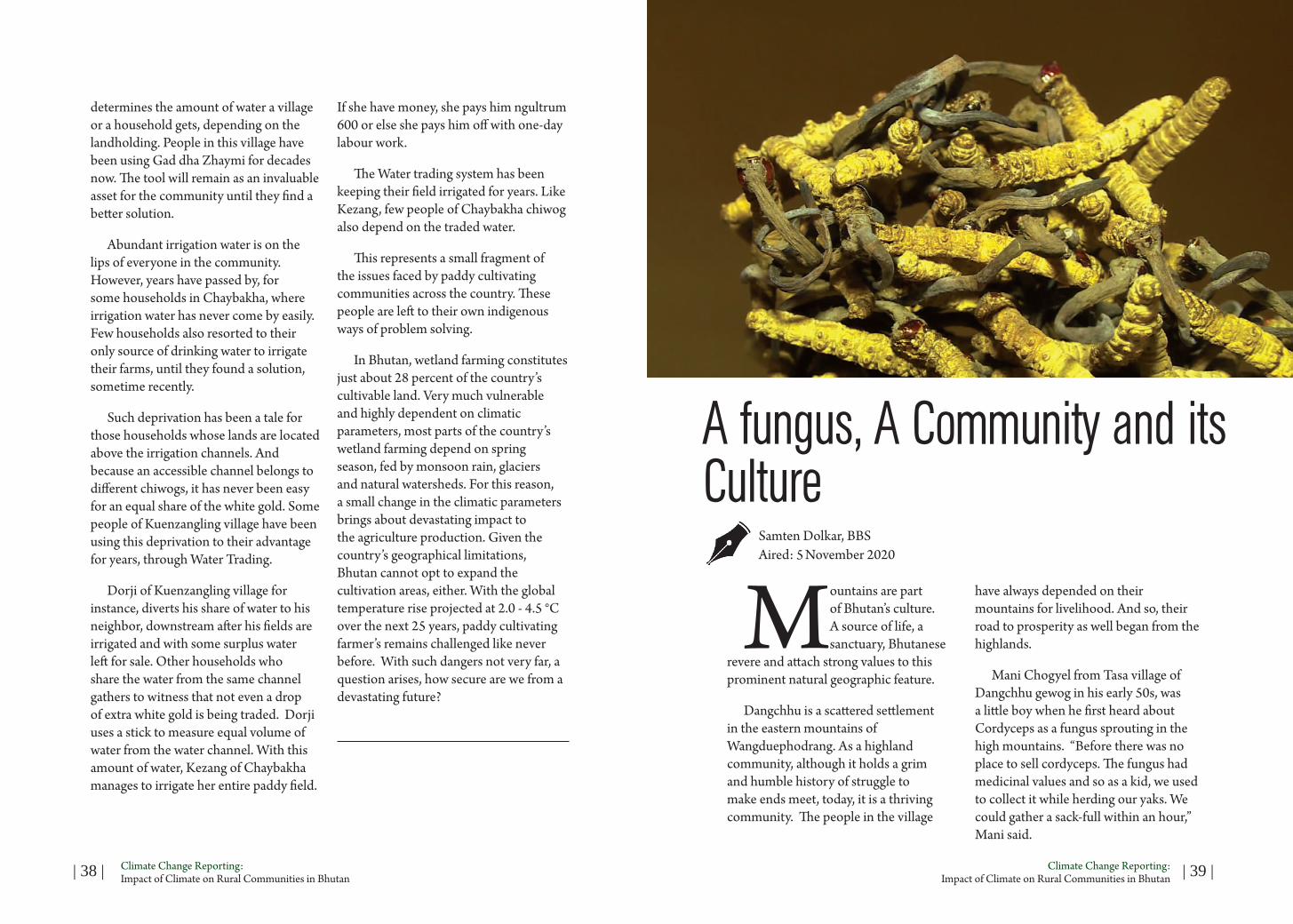
Little did he know then that it was another gift from the mountains that would soon change his fortune as well as that of his fellow villagers. Cordyceps is a parasitic fungus that attacks a number of insects, most notably caterpillars. It is found only in places at 4000 to 5000 meters altitude. In Bhutan, it is locally known as Yartsa-Guenbub, which literally translates the lifecycle of the fungus as ‘summer grass, winter worm’.
Mani said “People of Tasa collected Cordyceps while herding yaks. There was no auction held like today. A few villagers took the fungus to Thimphu for sale and some sold it to other people in the mountains.”
Bhutan legalized the collection Cordyceps in the country in 2004 following the Royal Command of His Majesty the Fourth DrukGyalpo. Since then, these people, young and old, men and women, have been spending their summers high up in the mountains.
Crawling on the ground, looking for the tonic fungus camouflaged in the sea of grass is as tiring as it is hazardous. But most times, these are belittled by the rewards of finding the world’s most expensive fungus.
A kilogram of the best quality Cordyceps could fetch as high as …ngultrum. Last year, from just nine places across the country, Cordyceps worth over 200 million ngultrum was collect as per (cite the source).
The soaring global demand, according
to many reports, is mainly due to the medicinal values of Cordyceps as a generic immune booster, or to treat a growing list of conditions, including cancer. It is ranked with the finest wild ginseng, Deer Antler and Reishi Mushroom as a life-promoting agent.
In Tasa, Mani Chogyal stands witness to how the winds of change swept through his village because of Yartsa-Guenbub.
“People of Tasa made a good income from Cordyeps. And with that money, some bought lands and built houses in Nobding while some constructed bigger houses in the village. Now, everyone is independent and financially stable. These are all due to the fungus” he said.
Such stories of affluence echo across the highlands where Codyceps has taken
the center stage as the main source of income while the world remains gripped by an increasing demand for the fungus. It has helped curb the endemic poverty often associated with the region.
From the struggles of living in dilapidated tents, today, the highland families boast of two-storied houses, decked elaborately in rich traditional paintings and financially stable enough to earn a handsome living.
Duba, a villager said “After we started harvesting cordyceps, much development took place. Today, because of the cordyceps, like anybody else, we have good clothes to wear, good food to eat and have a proper status among other people. The profit from the cordyceps gave home to a person who didn’t even have a proper roof. Some have bought lands and build houses.”
Singye Dorji, another villager said “After we moved out of my wife’s parents’ house, we lived in a hut. We stayed in it for nine or 10 long years. Then, I started collecting more Cordyceps and I made more money. Today, we live in a better house.”
But tough times lie ahead. The precious fungus is disappearing, perhaps faster than expected. With every passing year, the news of a poor harvest is becoming more and more common.
Duba said “The cordyceps harvest has decreased by almost 70 per cent compared to the past.”
In July, Cordycepssinensis was included in the Red List of the International Union for Conservation of Nature as vulnerable. According to the global environment body, the population of the fungus declined by at least 30 per cent over the past 15 years.
Multiple studies internationally show climate change and warmer winters as the reasons behind the dwindling yield of Cordyceps besides its untimely and overharvesting.
In Bhutan, research on the impacts of climate change on Cordyceps is limited. But from what farmers say, it is evident that cold winters, which are a perfect catalyst for the fungus to grow, are gradually becoming harder to come by.
Mani said “Before, as a child, when we went high up in the mountains, the mountains, lakes and air used to be very cool. The weather used to be very cold.

| 42 | Climate Change Reporting: Impact of Climate on Rural Communities in Bhutan | 43 |Climate Change Reporting:
Impact of Climate on Rural Communities in Bhutan
But later I don’t know if it’s because of increased number of people who went up there, but the place where it used to snow do not receive snow anymore. Even the climate is warmer than before.”
Duba said “The climate has changes drastically up there now. Before around November, it used to snow heavily. But these days, even if it snows, it melts within no time..”
Cordyceps growth is enhanced by unusually high precipitation during the preceding monsoon season or in the form of winter snowfall especially when followed by mild temperatures in spring.
Mani said “Cordyceps like any vegetables grow in area where there is enough water. It cannot grow in dry land. It can’t also grow in muddy land. There should be enough rain and water and the soil should be very loose and soft. It should grow in colder place with enough snow falls.”
Last year, the average minimum temperature of WangduePhodrang was recorded at 15ºC. This year, it fell to 13.9ºC. and the harvest was reportedly better.
Om Katel (PhD), Lecturer of Environment and Climate studies (ENG) said “When there is a change in climate, change in precipitation, there will be change in distribution of plant species is, structure of the plant species, and overall the ecology of forest ecosystem. And there are evidences from IPCC reports that with one to two degree Celsius, there
can have a significant change in forest species like composition, distribution and another interesting thing is that several evidences that shows that there is a upward movement of plants”
International research indicate that since 2000, Himalayan glaciers are losing nearly half a meter of ice a year vertically on average. In the final decades of the 20th century that loss was only around 22 centimeters a year, which indicates that climate change is accelerating snow melt in the Himalayas at a rate double what it was just a few decades ago.
Studies reveal that at higher elevations, where temperatures are naturally colder, there has been less loss of ice. Yet lower down, especially nearer ground level, glaciers are losing an alarming five meters of ice a year on average. The decrease of quality and quantiy of Cordyceps is perhaps a convincing indication that climate change is eating the Himalayas’ glacier.
He further added “We did this short study in Bhutan. It’s basically looking at the temperature precipitation data. What we have in Bhutan over the last 20, 25 years and we looked at this data and then we linked to the global climate models and our studies showed that over the year that is 1900 to 2001, there has been increase of 0.8 degree Celsius increase of temperature. And if you just look at this data very carefully, very critically, we have found that since 1981 until now, the average increase in temperature has been very significant. And surprisingly what it shows is that the increase in temperature
in Bhutan appears to be relatively higher than any other countries in South Asia. And this is consistent with IPCC report that suggest that temperature increase in Himalaya would be significantly higher than any other regions in the world.”
Amid the concerns over the disappearing fungus, highlanders are also confronted with another stark reality - the pressure the newfound wealth has put on their nomadic culture unconsciously.
Today, yaks are reared more as an identity characteristic than a necessity. The age-old tradition for sustenance has fallen casualty to the growing trend of collecting Cordyceps.
Pemba, Gup, Dangchhu, WangduePhodrang said “After the collection of Cordyceps picked up, people preferred fungus over yaks. Rearing yaks became an additional task and with everyone in the family involved in collecting cordyceps, there were no extra hands to spare. When it comes to gathering Cordyceps, people have to toil for a month or two and the returns are far better than rearing yaks. So slowly, some yaks died while others were sold-off.”
Today, there are over 4000 yaks in the highlands of WangduePhodrang. This is an increase in recent times following interventions from the livestock sector. However, people say that this upward trajectory in the yak population is negligible compared to a decade ago.
Yet all is not lost according to Dangchhu Gup Pemba. People
responding to the symptoms of over dependence on Cordyceps could prompt their return to old habits.
According to the Gup “From last year, with support from the gewog, we decided to revive our age old tradition of rearing yaks. People have come to us saying that yak rearing is ultimately going to benefit them in future. Going by the situation, we can’t always depend on cordyceps harvest. It would be difficult to sustain our lives. So people have been supporting us and some old people are now starting to go back to yak rearing now.”
“Now as year goes by, there are increasing number of collectors and less cordyceps. So we can’t guarantee that we make a living out of this cordyceps our entire life.” Singye added
Meanwhile, in Tasa, Mani Chogyel is also preparing his children to brace the future in ways he considers best. He says children are tempted to leave school for gathering Cordyceps. But as a father who has lived through a process in time, he does want the advantages they have at the moment as highlanders to also be the cause of a loss his children would feel very deeply.
Mani said “Some people do get tempted that cordyceps fetch them so much money. But as a tshogpa, I tell people in my village to give their children education. For a little profit from this business, if they do not educate themselves now, in future we can’t guarantee if we can really rely on it or not.”

| 44 | Climate Change Reporting: Impact of Climate on Rural Communities in Bhutan | 45 |Climate Change Reporting:
Impact of Climate on Rural Communities in Bhutan
Water shortage a national concern
Gopilal AcharyaPublished: Kuensel, January 2, 2021
As traditional sources dry up, farmers fear a future with insufficient water
The gewog of Barshong in Tsirang is a sprawling communities of human settlements along narrow ridges and steep slopes of the southern foothills. The gewog’s population of about 2,500 people are perennially thirsty, literally and figuratively. Simply said, the gewog faces acute water shortage. By contrast, the grand Sunkosh River flows at the foot of the Barshong hills.
The river is a constant reminder to the residents of Barshong why mankind’s survival so critically hinges on the continuous availability of water. Besides the considerable dry spell the gewog goes through, there are new water-related challenges that farmers have to deal with.
Across the Sunkosh River is Dagana, another district where several of its gewogs have of late reported severe water shortage. Dagaps say the traditional water sources have dried up leaving
communities to identify new ones, often far away from human settlements.
Up in the mountain valleys, in Wangduephodrang, people complain of dwindling amount of water for paddy cultivation. People have resorted to stealing water, if not buying from neighbors who do not need it in abundance. In Shaba, Paro, officials say four of the five springs have dried up in the past two decades.
For hundreds of households in Toeb and Baap gewogs in Punakha, the ever-dependable stream of Toeb-Rongchu is like a mother whose bountiful love is unconditional. But the naturally-fed stream, farmers say, is seeing a decrease in discharge over several years. The stream is now increasingly becoming a source of conflict among households and communities.

| 46 | Climate Change Reporting: Impact of Climate on Rural Communities in Bhutan | 47 |Climate Change Reporting:
Impact of Climate on Rural Communities in Bhutan
Bhutan’s farmers, who have for generations depended on subsistence farming, know it all—that rainfall is becoming erratic and unpredictable, that natural ponds and lakes are drying up, that spring and stream discharge is decreasing. In short, farming is becoming difficult. And more and more farmers, from Dagana to Paro to Pemagatshel, are today worried about future without sufficient water.
“In the past, rains lasted for several months,” says Raj Kumar Moktan, 56, of Gangtokha in Barshong. “We received rain from April till August. But today, you never know when it comes and when it goes. It has become extremely unpredictable.”
Are water sources really drying up?
There are increasing reports from communities across the country that water sources are drying up. In many parts of Bhutan, farmers share the same distressing stories, that water availability has become highly seasonal.
Increasing variability and unpredictability of rainfall is already posing new challenges to farmers. They say rainfall these days lasts for shorter period and people are now switching from the cultivation of more water intensive crops like paddy to less water intensive crops. In some cases, farmers have altogether abandoned paddy cultivation.
“Paddy cultivation does not make sense anymore,” says a Samtse farmer.
“First, there is water shortage, and then there is the shortage of farmhands. Young people do not want to do the dirty work.”
Farmers also complain of increased pest and diseases and crop failure, especially during extended dry spells. Water scarcity will have a direct impact on food security as more farmers hang up their plough to explore alternative livelihood or simply abandon villages for urban lure.
Yet, Bhutan has one of the highest per capita availability of water in the world. Official figures show that Bhutan generates about 70,500 million m3 per annum, meaning each Bhutanese should ideally have access to about 94,500 m3 per person per year.
Experts say poor governance and management are some underlying causes for water shortage in the country. Disturbances at the catchment, change in land use pattern, forest fires, disturbance of natural vegetation, and climate change could be contributing to the dwindling water availability.
Further, rainfall patterns have changed from long monsoon cycles to erratic downpours and this is not giving enough rain to recharge to the aquifers, which are a critical component of watersheds.
The numerous farm roads constructed in the past 15 years would have also disturbed the movement and distribution of groundwater, say officials. Many rural roads in Bhutan have been built without mapping recharge areas.
What can be done?
While modest work has begun to address the issue, the country still lacks considerable expertise for a nationwide intervention. For example, work has begun at the pilot site in Lholing in Paro for spring revival and spring-shed management. Some capacity building exercises for officials and local leaders have also been carried out. And one of the components of the national flagship program on ‘Water and Irrigation’ is to protect critical watersheds and wetlands.
Rehabilitating degraded sources should be at the core of the spring revival interventions, say experts. To this end, a team of Bhutanese officials also visited Sikkim to learn from its popular Dhara Vikas Initiative. Under this Initiative, Sikkim has been able to revive several dying lakes, springs, and streams. Given geographical similarities between Bhutan and Sikkim, officials feel lessons from Sikkim could be useful.
The big challenge, however, is the lack of comprehensive data. Further, most farmers are not aware of small-scale efficient water management practices such as rainwater harvesting, drip irrigation, plastic-lined conservation pond, and water recharge ponds.
Barshong has been lucky, though. Through an European Union-funded project on rural livelihoods managed by the International Centre for Integrated
Mountain Development, several households in Barshong geowg have constructed plastic-lined conservation ponds. These ponds store as much as 18,000 liters of water, and can be used for irrigation as well as for vegetable production. The water can also be used for fish farming and other domestic purposes.
However, better management of springs and deepening community ownership of water sources should be focus in the long run, experts say. Better distribution systems with minimal wastage should be introduced. Environmental impact assessments should reflect recharge areas and mark them as protected zones. Development activities, especially the ones that cause considerable damage to the environment, could be discouraged.
In the meanwhile, for the people of Toeb and Baap, the end of each cycle of paddy cultivation is a moment of jubilation. The deities have answered the prayers, and people will not go hungry. The ever-dependable Toeb-Rongchu has not yet failed.
Or could it, someday?

BHUTAN MEDIA FOUNDATION Telephone: 00975-02-331705 | 331709 | P.O. Box: 1655
Lhado Lam | Thimphu, Bhutan | Email: [email protected] | www.bmf.bt