Embed Size (px)
Citation preview
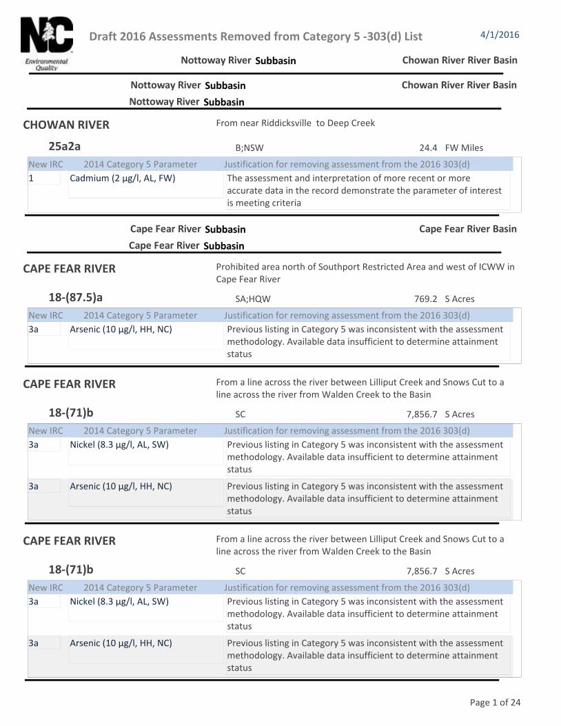
Draft 2016 Assessments Removed from Category 5 -303(d) List 4/1/2016
Nottoway River Subbasin Chowan River River Basin
Nottoway River Subbasin Chowan River River Basin
Nottoway River Subbasin
CHOWAN RIVER From near Riddicksville to Deep Creek
24.4 FW MilesB;NSW25a2a
New IRC Justification for removing assessment from the 2016 303(d) 2014 Category 5 Parameter
1 The assessment and interpretation of more recent or more accurate data in the record demonstrate the parameter of interest is meeting criteria
Cadmium (2 µg/l, AL, FW)
Cape Fear River Subbasin Cape Fear River Basin
Cape Fear River Subbasin
CAPE FEAR RIVER Prohibited area north of Southport Restricted Area and west of ICWW in Cape Fear River
769.2 S AcresSA;HQW18-(87.5)a
New IRC Justification for removing assessment from the 2016 303(d) 2014 Category 5 Parameter
3a Previous listing in Category 5 was inconsistent with the assessment methodology. Available data insufficient to determine attainment status
Arsenic (10 µg/l, HH, NC)
CAPE FEAR RIVER From a line across the river between Lilliput Creek and Snows Cut to a line across the river from Walden Creek to the Basin
7,856.7 S AcresSC18-(71)b
New IRC Justification for removing assessment from the 2016 303(d) 2014 Category 5 Parameter
3a Previous listing in Category 5 was inconsistent with the assessment methodology. Available data insufficient to determine attainment status
Nickel (8.3 µg/l, AL, SW)
3a Previous listing in Category 5 was inconsistent with the assessment methodology. Available data insufficient to determine attainment status
Arsenic (10 µg/l, HH, NC)
Page 1 of 24

Draft 2016 Assessments Removed from Category 5 -303(d) List 4/1/2016
Deep River Subbasin Cape Fear River Basin
Deep River Subbasin
DEEP RIVER From Gabriels Creek to Brush Creek
18.2 FW MilesC17-(10.5)d2
New IRC Justification for removing assessment from the 2016 303(d) 2014 Category 5 Parameter
3a Previous listing in Category 5 was inconsistent with the assessment methodology. Available data insufficient to determine attainment status
Copper (7 µg/l, AL, FW)
Richland Creek From a point 0.4 mile upstream of Guilford County SR 1154 to Randleman Reservoir, Deep River
1.7 FW MilesWS-IV;CA:*17-7-(4)
New IRC Justification for removing assessment from the 2016 303(d) 2014 Category 5 Parameter
1 The assessment and interpretation of more recent or more accurate data in the record demonstrate the parameter of interest is meeting criteria
Fish Community Fair (Nar, AL, FW)
Haw River Subbasin
Back Creek (Graham-Mebane Rese Quaker Creek Arm of Graham-Mebane Reservoir
113.0 FW AcresWS-II;HQW,NSW,CA16-18-(1.5)b
New IRC Justification for removing assessment from the 2016 303(d) 2014 Category 5 Parameter
3a The assessment and interpretation of more recent or more accurate data in the record demonstrate the parameter of interest is meeting criteria
Turbidity (25 NTU, AL, FW acres & SW)
Big Alamance Creek (Alamance Cr) From Dam at Lake Macintosh to confluence with Stinking Quarter Creek
5.6 FW MilesWS-V;NSW16-19-(4.5)a
New IRC Justification for removing assessment from the 2016 303(d) 2014 Category 5 Parameter
1 The assessment and interpretation of more recent or more accurate data in the record demonstrate the parameter of interest is meeting criteria
Benthos Fair (Nar, AL, FW)
HAW RIVER From SR 2426 to Troublesome Creek at US29
7.3 FW MilesWS-V;NSW16-(1)c1
New IRC Justification for removing assessment from the 2016 303(d) 2014 Category 5 Parameter
3a Previous listing in Category 5 was inconsistent with the assessment methodology. Available data insufficient to determine attainment status
Copper (7 µg/l, AL, FW)
Page 2 of 24

Draft 2016 Assessments Removed from Category 5 -303(d) List 4/1/2016
Haw River Subbasin Cape Fear River Basin
Haw River (B. Everett Jordan Lake Robeson Creek Arm of Jordan Reservoir
47.0 FW AcresWS-IV,B;NSW,CA16-(37.5)b
New IRC Justification for removing assessment from the 2016 303(d) 2014 Category 5 Parameter
1t The assessment and interpretation of more recent or more accurate data in the record demonstrate the parameter of interest is meeting criteria
Turbidity (25 NTU, AL, FW acres & SW)
Little Alamance Creek (Gant Lake, From source to Big Alamance Creek
12.6 FW MilesWS-V;NSW16-19-11
New IRC Justification for removing assessment from the 2016 303(d) 2014 Category 5 Parameter
4b Watershed managment plan implementation will result in attainment of water quality standards
Ecological/biological Integrity Benthos (Nar, AL, FW)
Morgan Creek (including the Morg From Chatham County SR 1726 (Durham County SR 1109) to New Hope Creek Arm of New Hope River Arm of B. Everett Jordan Lake
836.2 FW AcresWS-IV;NSW,CA16-41-2-(9.5)
New IRC Justification for removing assessment from the 2016 303(d) 2014 Category 5 Parameter
4t TMDL completed and approved by EPATurbidity (25 NTU, AL, FW acres & SW)
New Hope Creek (including New H From a point 0.8 mile downstream of Durham County SR 1107 to confluence with Morgan Creek Arm of New Hope River Arm of B. Everett Jordan Lake
1,415.7 FW AcresWS-IV;NSW,CA16-41-1-(14)
New IRC Justification for removing assessment from the 2016 303(d) 2014 Category 5 Parameter
4t TMDL completed and approved by EPATurbidity (25 NTU, AL, FW acres & SW)
North Buffalo Creek From source to Philadelphia Lake
7.5 FW MilesWS-V;NSW16-11-14-1a1
New IRC Justification for removing assessment from the 2016 303(d) 2014 Category 5 Parameter
1 The assessment and interpretation of more recent or more accurate data in the record demonstrate the parameter of interest is meeting criteria
Fish Community Poor (Nar, AL, FW)
Page 3 of 24

Draft 2016 Assessments Removed from Category 5 -303(d) List 4/1/2016
Haw River Subbasin Cape Fear River Basin
Northeast Creek From Kit Creek to a point 0.5 mile downstream of Panther Creek
3.2 FW MilesWS-IV;NSW16-41-1-17-(0.7)b2
New IRC Justification for removing assessment from the 2016 303(d) 2014 Category 5 Parameter
3a Previous listing in Category 5 was inconsistent with the assessment methodology. Available data insufficient to determine attainment status
Copper (7 µg/l, AL, FW)
Reedy Fork (Hardys Mill Pond) From Buffalo Creek to Haw River
8.6 FW MilesWS-V;NSW16-11-(9)b
New IRC Justification for removing assessment from the 2016 303(d) 2014 Category 5 Parameter
3a Previous listing in Category 5 was inconsistent with the assessment methodology. Available data insufficient to determine attainment status
Zinc (50 µg/l, AL, FW)
South Buffalo Creek From US 70 to Buffalo Creek
4.8 FW MilesWS-V;NSW16-11-14-2c
New IRC Justification for removing assessment from the 2016 303(d) 2014 Category 5 Parameter
1 The assessment and interpretation of more recent or more accurate data in the record demonstrate the parameter of interest is meeting criteria
Copper (7 µg/l, AL, FW)
Third Fork Creek From source to a point 2.0 miles upstream of NC Hwy. 54
5.2 FW MilesWS-V;NSW16-41-1-12-(1)
New IRC Justification for removing assessment from the 2016 303(d) 2014 Category 5 Parameter
3a Previous listing in Category 5 was inconsistent with the assessment methodology. Available data insufficient to determine attainment status
Copper (7 µg/l, AL, FW)
Third Fork Creek From a point 2.0 miles upstream of NC HWY. 54 to New Hope Creek
3.9 FW MilesWS-IV;NSW16-41-1-12-(2)
New IRC Justification for removing assessment from the 2016 303(d) 2014 Category 5 Parameter
3a Previous listing in Category 5 was inconsistent with the assessment methodology. Available data insufficient to determine attainment status
Copper (7 µg/l, AL, FW)
Little River-Cape Fear River Subbasin
Page 4 of 24

Draft 2016 Assessments Removed from Category 5 -303(d) List 4/1/2016
Little River-Cape Fear River Subbasin Cape Fear River Basin
CAPE FEAR RIVER From Lillington water supply intake to Upper Little River
9.0 FW MilesWS-IV18-(16.7)
New IRC Justification for removing assessment from the 2016 303(d) 2014 Category 5 Parameter
3a Previous listing in Category 5 was inconsistent with the assessment methodology. Available data insufficient to determine attainment status
Copper (7 µg/l, AL, FW)
Kenneth Creek From Wake-Harnett County Line to Neils Creek
3.9 FW MilesWS-IV18-16-1-(2)
New IRC Justification for removing assessment from the 2016 303(d) 2014 Category 5 Parameter
3a The assessment and interpretation of more recent or more accurate data in the record demonstrate the parameter of interest is meeting criteria
pH (6 su, AL, FW)
4s Pollutant causing impairment identified. TMDL implementation will result in attainment of water quality standards
Benthos Fair (Nar, AL, FW)
Lick Creek From dam at Olhams Lake to Cape Fear River
10.3 FW MilesWS-IV18-4-(2)
New IRC Justification for removing assessment from the 2016 303(d) 2014 Category 5 Parameter
3a The assessment and interpretation of more recent or more accurate data in the record demonstrate the parameter of interest is meeting criteria
pH (6 su, AL, FW)
Page 5 of 24

Draft 2016 Assessments Removed from Category 5 -303(d) List 4/1/2016
Little River-Cape Fear River Subbasin Cape Fear River Basin
Ut to Locks Creek From source to Locks Creek
1.9 FW Miles18-28ut3
New IRC Justification for removing assessment from the 2016 303(d) 2014 Category 5 Parameter
3a Previous listing in Category 5 was inconsistent with the assessment methodology. Available data insufficient to determine attainment status
Zinc (50 µg/l, AL, FW)
3a Previous listing in Category 5 was inconsistent with the assessment methodology. Available data insufficient to determine attainment status
Arsenic (10 µg/l, HH, NC)
Northeast Cape Fear River Subbasin
Northeast Cape Fear River From mouth of Ness Creek to Cape Fear River
1.0 S AcresSC;Sw18-74-(61)
New IRC Justification for removing assessment from the 2016 303(d) 2014 Category 5 Parameter
3a Previous listing in Category 5 was inconsistent with the assessment methodology. Available data insufficient to determine attainment status
Copper (7 µg/l, AL, FW)
Catawba River Subbasin Catawba River Basin
Catawba River Subbasin
Irwin Creek From source to Sugar Creek
11.8 FW MilesC11-137-1
New IRC Justification for removing assessment from the 2016 303(d) 2014 Category 5 Parameter
3a Previous listing in Category 5 was inconsistent with the assessment methodology. Available data insufficient to determine attainment status
Lead (25 µg/l, AL, NC)
3a Previous listing in Category 5 was inconsistent with the assessment methodology. Available data insufficient to determine attainment status
Zinc (50 µg/l, AL, FW)
Page 6 of 24

Draft 2016 Assessments Removed from Category 5 -303(d) List 4/1/2016
Catawba River Subbasin Catawba River Basin
Irwin Creek From source to Sugar Creek
11.8 FW MilesC11-137-1
New IRC Justification for removing assessment from the 2016 303(d) 2014 Category 5 Parameter
3a Previous listing in Category 5 was inconsistent with the assessment methodology. Available data insufficient to determine attainment status
Lead (25 µg/l, AL, NC)
3a Previous listing in Category 5 was inconsistent with the assessment methodology. Available data insufficient to determine attainment status
Zinc (50 µg/l, AL, FW)
Twelvemile Creek From source to North Carolina-South Carolina State Line
3.0 FW MilesC11-138
New IRC Justification for removing assessment from the 2016 303(d) 2014 Category 5 Parameter
3a Previous listing in Category 5 was inconsistent with the assessment methodology. Available data insufficient to determine attainment status
Copper (7 µg/l, AL, FW)
Waxhaw Creek From source to North Carolina-South Carolina State Line
16.3 FW MilesC11-139
New IRC Justification for removing assessment from the 2016 303(d) 2014 Category 5 Parameter
1 The assessment and interpretation of more recent or more accurate data in the record demonstrate the parameter of interest is meeting criteria
Fish Community Poor (Nar, AL, FW)
West Fork Twelvemile Creek From source to Twelvemile Creeek
12.9 FW MilesC11-138-1
New IRC Justification for removing assessment from the 2016 303(d) 2014 Category 5 Parameter
1 The assessment and interpretation of more recent or more accurate data in the record demonstrate the parameter of interest is meeting criteria
Fish Community Poor (Nar, AL, FW)
Catawba River Headwaters Subbasin
Harper Creek From source to Wilson Creek
9.1 FW MilesC;Tr,ORW11-38-34-14
New IRC Justification for removing assessment from the 2016 303(d) 2014 Category 5 Parameter
4t TMDL completed and approved by EPApH (6 su, AL, FW)
Page 7 of 24

Draft 2016 Assessments Removed from Category 5 -303(d) List 4/1/2016
Catawba River Headwaters Subbasin Catawba River Basin
Shooks Creek From source to Linville River
2.9 FW MilesC;Tr11-29-22
New IRC Justification for removing assessment from the 2016 303(d) 2014 Category 5 Parameter
4t TMDL completed and approved by EPApH (6 su, AL, FW)
UT to Frankum Creek From source to Frankum Creek
0.9 FW Miles11-38-32-9ut3
New IRC Justification for removing assessment from the 2016 303(d) 2014 Category 5 Parameter
4t TMDL completed and approved by EPApH (6 su, AL, FW)
South Fork of the Catawba River Subbasin
Clark Creek From a point 0.9 mile upstream of Walker Creek to South Fork Catawba R.
1.8 FW MilesWS-IV11-129-5-(9.5)
New IRC Justification for removing assessment from the 2016 303(d) 2014 Category 5 Parameter
3a Previous listing in Category 5 was inconsistent with the assessment methodology. Available data insufficient to determine attainment status
Copper (7 µg/l, AL, FW)
Jacob Fork From Little River to Camp Creek
6.8 FW MilesWS-III;ORW11-129-2-(4)
New IRC Justification for removing assessment from the 2016 303(d) 2014 Category 5 Parameter
3a The assessment and interpretation of more recent or more accurate data in the record demonstrate the parameter of interest is meeting criteria
pH (6 su, AL, FW)
French Broad River Subbasin French Broad River Basin
French Broad River Subbasin
Davidson River From Avery Creek to Olin Corporation Water Supply Dam
2.7 FW MilesWS-V,B;Tr6-34-(15.5)
New IRC Justification for removing assessment from the 2016 303(d) 2014 Category 5 Parameter
4t TMDL completed and approved by EPApH (6 su, AL, FW)
Page 8 of 24

Draft 2016 Assessments Removed from Category 5 -303(d) List 4/1/2016
French Broad River Subbasin French Broad River Basin
Mills River From River Mile 1.03 to a point 0.5 mile upstream of N.C. Hwy. 191
1.8 FW MilesWS-II;Tr,HQW6-54-(1)b
New IRC Justification for removing assessment from the 2016 303(d) 2014 Category 5 Parameter
3a The assessment and interpretation of more recent or more accurate data in the record demonstrate the parameter of interest is meeting criteria
pH (6 su, AL, FW)
Nolichucky River Subbasin
NOLICHUCKY RIVER From source to North Carolina-Tennessee State Line
10.0 FW MilesB7
New IRC Justification for removing assessment from the 2016 303(d) 2014 Category 5 Parameter
3a Previous listing in Category 5 was inconsistent with the assessment methodology. Available data insufficient to determine attainment status
Copper (7 µg/l, AL, FW)
North Toe River From a point 0.2 mile upstream of Pyatt Creek to a point 0.5 mile upstream of U.S. Hwy. 19E
9.4 FW MilesWS-IV;Tr7-2-(21.5)
New IRC Justification for removing assessment from the 2016 303(d) 2014 Category 5 Parameter
3a The assessment and interpretation of more recent or more accurate data in the record demonstrate the parameter of interest is meeting criteria
Turbidity (10 NTU, AL, Tr)
3a Previous listing in Category 5 was inconsistent with the assessment methodology. Available data insufficient to determine attainment status
Copper (7 µg/l, AL, FW)
Page 9 of 24

Draft 2016 Assessments Removed from Category 5 -303(d) List 4/1/2016
Nolichucky River Subbasin French Broad River Basin
South Toe River From source to U.S. Hwy. 19E
25.9 FW MilesB;Tr,ORW7-2-52-(1)
New IRC Justification for removing assessment from the 2016 303(d) 2014 Category 5 Parameter
3t TMDL completed and approved by EPApH (6 su, AL, FW)
Pigeon River Subbasin
Richland Creek From Lake Junaluska Dam to Jones Cove Branch
1.6 FW MilesC5-16-(16)a
New IRC Justification for removing assessment from the 2016 303(d) 2014 Category 5 Parameter
1 The assessment and interpretation of more recent or more accurate data in the record demonstrate the parameter of interest is meeting criteria
Fish Community Fair (Nar, AL, FW)
Hiwassee River Subbasin Hiwassee River Basin
Hiwassee River Subbasin
Martin Creek From source to Hiwassee River
8.8 FW MilesC1-49
New IRC Justification for removing assessment from the 2016 303(d) 2014 Category 5 Parameter
1 The assessment and interpretation of more recent or more accurate data in the record demonstrate the parameter of interest is meeting criteria
Fish Community Fair (Nar, AL, FW)
Long Bay-Atlantic Ocean Subbasin Lumber River Basin
Long Bay-Atlantic Ocean Subbasin
Calabash River From source to North Carolina-South Carolina State Line
139.9 S AcresSA;HQW15-25-13
New IRC Justification for removing assessment from the 2016 303(d) 2014 Category 5 Parameter
3a The assessment and interpretation of more recent or more accurate data in the record demonstrate the parameter of interest is meeting criteria
Turbidity (25 NTU, AL, FW acres & SW)
Waccamaw River Subbasin
Page 10 of 24

Draft 2016 Assessments Removed from Category 5 -303(d) List 4/1/2016
Waccamaw River Subbasin Lumber River Basin
WACCAMAW RIVER From SR 1928 to NC 130
8.9 FW MilesC;Sw15-(1)d
New IRC Justification for removing assessment from the 2016 303(d) 2014 Category 5 Parameter
3a The assessment and interpretation of more recent or more accurate data in the record demonstrate the parameter of interest is meeting criteria
pH (4.3 su, AL, Sw)
Little Tennessee River Subbasin Little Tennessee River Basin
Little Tennessee River Subbasin
LITTLE TENNESSEE RIVER From North Carolina-Georgia State line to the confluence of Mulberry Creek
2.1 FW MilesC2-(1)a
New IRC Justification for removing assessment from the 2016 303(d) 2014 Category 5 Parameter
1 The assessment and interpretation of more recent or more accurate data in the record demonstrate the parameter of interest is meeting criteria
Fish Community Fair (Nar, AL, FW)
Contentnea Creek Subbasin Neuse River Basin
Contentnea Creek Subbasin
Turkey Creek From Old Middlesex Road to SR 1101
2.0 FW MilesC;NSW27-86-3-(1)a2
New IRC Justification for removing assessment from the 2016 303(d) 2014 Category 5 Parameter
3a The assessment and interpretation of more recent or more accurate data in the record demonstrate the parameter of interest is meeting criteria
Dissolved Oxygen (4 mg/l, AL, FW)
Lower Neuse River Subbasin
Neal Creek From source to South Prong Bay River
1.3 S AcresSC;Sw,NSW27-150-3-1
New IRC Justification for removing assessment from the 2016 303(d) 2014 Category 5 Parameter
3z1 Flaws in the original analysis of data and information led to assessment being incorrectly listed in Category 5
Shellfish Growing Area-Prohibited (Fecal, SH, SA)
Page 11 of 24

Draft 2016 Assessments Removed from Category 5 -303(d) List 4/1/2016
Lower Neuse River Subbasin Neuse River Basin
NEUSE RIVER Estuary From Trent River to a line across Neuse River from Johnson Point to McCotter Point (part of upper model segment)
3,473.6 S AcresSC;Sw,NSW27-(96)b2
New IRC Justification for removing assessment from the 2016 303(d) 2014 Category 5 Parameter
3a Previous listing in Category 5 was inconsistent with the assessment methodology. Available data insufficient to determine attainment status
Copper (3 µg/l, AL, SW)
South Prong Bay River From source to Bay River
27.4 S AcresSC;Sw,NSW27-150-3
New IRC Justification for removing assessment from the 2016 303(d) 2014 Category 5 Parameter
3z1 Flaws in the original analysis of data and information led to assessment being incorrectly listed in Category 5
Shellfish Growing Area-Prohibited (Fecal, SH, SA)
Upper Neuse River Subbasin
Eno River From source to a point 0.4 mile upstream of Dry Run
2.2 FW MilesWS-II;HQW,NSW27-2-(1)
New IRC Justification for removing assessment from the 2016 303(d) 2014 Category 5 Parameter
1 The assessment and interpretation of more recent or more accurate data in the record demonstrate the parameter of interest is meeting criteria
Benthos Fair (Nar, AL, FW)
Mill Creek (Moorewood Pond) From source to Stone Creek
11.3 FW MilesC;NSW27-52-(1)b
New IRC Justification for removing assessment from the 2016 303(d) 2014 Category 5 Parameter
3a The assessment and interpretation of more recent or more accurate data in the record demonstrate the parameter of interest is meeting criteria
Dissolved Oxygen (4 mg/l, AL, FW)
NEUSE RIVER From Crabtree Creek to Auburn Knightdale Road
3.9 FW MilesC;NSW27-(22.5)c
New IRC Justification for removing assessment from the 2016 303(d) 2014 Category 5 Parameter
3a Previous listing in Category 5 was inconsistent with the assessment methodology. Available data insufficient to determine attainment status
Copper (7 µg/l, AL, FW)
Page 12 of 24

Draft 2016 Assessments Removed from Category 5 -303(d) List 4/1/2016
Upper Neuse River Subbasin Neuse River Basin
NEUSE RIVER From a point 0.5 miles upstream of Richardson Bridge Road/SR 1201 to Johnston County's intake at Richardson Bridge Road/SR 1201
0.8 FW MilesWS-IV;NSW,CA27-(49.75)
New IRC Justification for removing assessment from the 2016 303(d) 2014 Category 5 Parameter
3a Previous listing in Category 5 was inconsistent with the assessment methodology. Available data insufficient to determine attainment status
Copper (7 µg/l, AL, FW)
NEUSE RIVER From mouth of Beddingfield Creek to a point 0.2 mile downstream of Johnston County SR 1700
4.3 FW MilesWS-V;NSW27-(36)
New IRC Justification for removing assessment from the 2016 303(d) 2014 Category 5 Parameter
3a Previous listing in Category 5 was inconsistent with the assessment methodology. Available data insufficient to determine attainment status
Copper (7 µg/l, AL, FW)
3a Previous listing in Category 5 was inconsistent with the assessment methodology. Available data insufficient to determine attainment status
Zinc (50 µg/l, AL, FW)
NEUSE RIVER From a point 0.2 mile downstream of Johnston County SR 1700 to point 1.4 mile downstream of Johnston County SR 1908
9.7 FW MilesWS-IV;NSW27-(38.5)
New IRC Justification for removing assessment from the 2016 303(d) 2014 Category 5 Parameter
1 Flaws in the original analysis of data and information led to assessment being incorrectly listed in Category 5
Copper (7 µg/l, AL, FW)
NEUSE RIVER From mouth of Beddingfield Creek to a point 0.2 mile downstream of Johnston County SR 1700
4.3 FW MilesWS-V;NSW27-(36)
New IRC Justification for removing assessment from the 2016 303(d) 2014 Category 5 Parameter
3a Previous listing in Category 5 was inconsistent with the assessment methodology. Available data insufficient to determine attainment status
Copper (7 µg/l, AL, FW)
3a Previous listing in Category 5 was inconsistent with the assessment methodology. Available data insufficient to determine attainment status
Zinc (50 µg/l, AL, FW)
Page 13 of 24

Draft 2016 Assessments Removed from Category 5 -303(d) List 4/1/2016
Upper Neuse River Subbasin Neuse River Basin
Walnut Creek From UT 0.6 miles west of I-440 to Neuse River
3.7 FW MilesC;NSW27-34-(4)b
New IRC Justification for removing assessment from the 2016 303(d) 2014 Category 5 Parameter
3a Previous listing in Category 5 was inconsistent with the assessment methodology. Available data insufficient to determine attainment status
Copper (7 µg/l, AL, FW)
Upper New River Subbasin New River Basin
Upper New River Subbasin
Crab Creek From source to Little River
7.8 FW MilesC;Tr10-9-12
New IRC Justification for removing assessment from the 2016 303(d) 2014 Category 5 Parameter
1 The assessment and interpretation of more recent or more accurate data in the record demonstrate the parameter of interest is meeting criteria
Fish Community Fair (Nar, AL, FW)
Naked Creek From 0.4 miles above Jefferson WWTP to Little Naked Creek
1.4 FW MilesC:+10-1-32b1
New IRC Justification for removing assessment from the 2016 303(d) 2014 Category 5 Parameter
1 The assessment and interpretation of more recent or more accurate data in the record demonstrate the parameter of interest is meeting criteria
Fish Community Fair (Nar, AL, FW)
Naked Creek From Little Naked Creek to South Fork New River
1.1 FW MilesC:+10-1-32b2
New IRC Justification for removing assessment from the 2016 303(d) 2014 Category 5 Parameter
1 The assessment and interpretation of more recent or more accurate data in the record demonstrate the parameter of interest is meeting criteria
Fish Community Fair (Nar, AL, FW)
South Fork New River From 0.1 mile downstream Hunting Lane to US Hwy.221/421
5.1 FW MilesC:+10-1-(3.5)b
New IRC Justification for removing assessment from the 2016 303(d) 2014 Category 5 Parameter
1 The assessment and interpretation of more recent or more accurate data in the record demonstrate the parameter of interest is meeting criteria
Benthos Fair (Nar, AL, FW)
Albemarle Sound Subbasin Pasquotank River Basin
Albemarle Sound Subbasin
Page 14 of 24

Draft 2016 Assessments Removed from Category 5 -303(d) List 4/1/2016
Albemarle Sound Subbasin Pasquotank River Basin
Currituck Sound From source to Wright Memorial Bridge at Albemarle Sound
69,301.2 S AcresSC30-1a1
New IRC Justification for removing assessment from the 2016 303(d) 2014 Category 5 Parameter
1 The assessment and interpretation of more recent or more accurate data in the record demonstrate the parameter of interest is meeting criteria
Enterrococcus (GM 35, REC, SW) 5n30
Pasquotank River From a line across River from Hospital Point to Cobb Point to a line across River from Miller Point to Pool Point
9,185.6 S AcresSB30-3-(12)
New IRC Justification for removing assessment from the 2016 303(d) 2014 Category 5 Parameter
3a The assessment and interpretation of more recent or more accurate data in the record demonstrate the parameter of interest is meeting criteria
pH (6.8 su, AL, SW)
Dan River Subbasin Roanoke River Basin
Dan River Subbasin
Marlowe Creek From Mithcell Creek to Storys Creek
4.5 FW MilesC22-58-12-6b
New IRC Justification for removing assessment from the 2016 303(d) 2014 Category 5 Parameter
3a Previous listing in Category 5 was inconsistent with the assessment methodology. Available data insufficient to determine attainment status
Copper (7 µg/l, AL, FW)
Dan River Headwaters Subbasin
Smith River From North Carolina-Virginia State Line to a point 0.8 mile downstream of Rockingham County SR 1714 (Aiken Road)
2.8 FW MilesWS-IV22-40-(1)
New IRC Justification for removing assessment from the 2016 303(d) 2014 Category 5 Parameter
1 The assessment and interpretation of more recent or more accurate data in the record demonstrate the parameter of interest is meeting criteria
Copper (7 µg/l, AL, FW)
Lake Gaston-Roanoke River Subbasin
Page 15 of 24

Draft 2016 Assessments Removed from Category 5 -303(d) List 4/1/2016
Lake Gaston-Roanoke River Subbasin Roanoke River Basin
Smith Creek From SR1208 to North Carolina-Virginia State Line
3.0 FW MilesC23-10c
New IRC Justification for removing assessment from the 2016 303(d) 2014 Category 5 Parameter
1 The assessment and interpretation of more recent or more accurate data in the record demonstrate the parameter of interest is meeting criteria
Fish Community Fair (Nar, AL, FW)
Pamlico River Subbasin Tar-Pamlico River Basin
Pamlico River Subbasin
Chocowinity Bay From a line across the Bay from the upstream mouth of Cedar Creek to the upstream mouth of Silas Creek to Pamlico River
503.2 S AcresSB;NSW29-6-(5)
New IRC Justification for removing assessment from the 2016 303(d) 2014 Category 5 Parameter
3a Previous listing in Category 5 was inconsistent with the assessment methodology. Available data insufficient to determine attainment status
Copper (3 µg/l, AL, SW)
PAMLICO RIVER From a line across Pamlico River from Cousin Point to Hickory Point to a line across Pamlico River from Roos Point to Persimmon Tree Point
33,766.4 S AcresSA;HQW,NSW29-(27)
New IRC Justification for removing assessment from the 2016 303(d) 2014 Category 5 Parameter
3a Previous listing in Category 5 was inconsistent with the assessment methodology. Available data insufficient to determine attainment status
Copper (3 µg/l, AL, SW)
Pantego Creek From U.S. Hwy. 264 at Pantego to Pungo River
952.4 S AcresSC;NSW29-34-34-(2)
New IRC Justification for removing assessment from the 2016 303(d) 2014 Category 5 Parameter
1 The assessment and interpretation of more recent or more accurate data in the record demonstrate the parameter of interest is meeting criteria
Chlorophyll a (40 µg/l, AL, NC)
Pungo Creek From source to Pungo River
1,701.6 S AcresSC;NSW29-34-35
New IRC Justification for removing assessment from the 2016 303(d) 2014 Category 5 Parameter
3a The assessment and interpretation of more recent or more accurate data in the record demonstrate the parameter of interest is meeting criteria
Chlorophyll a (40 µg/l, AL, NC)
Pamlico Sound Subbasin
Page 16 of 24

Draft 2016 Assessments Removed from Category 5 -303(d) List 4/1/2016
Pamlico Sound Subbasin Tar-Pamlico River Basin
Swanquarter Bay DEH closed area west of Swanquarter
136.2 S AcresSA;ORW29-49a
New IRC Justification for removing assessment from the 2016 303(d) 2014 Category 5 Parameter
1 The assessment and interpretation of more recent or more accurate data in the record demonstrate the parameter of interest is meeting criteria
Enterrococcus (GM 35, REC, SW) 5n30
Tar River Headwaters Subbasin
Stony Creek (Boddies Millpond) From Lassiters Creek to Tar River
5.9 FW MilesC;NSW28-68b
New IRC Justification for removing assessment from the 2016 303(d) 2014 Category 5 Parameter
1 The assessment and interpretation of more recent or more accurate data in the record demonstrate the parameter of interest is meeting criteria
Dissolved Oxygen (4 mg/l, AL, FW)
Subbasin White Oak River Basin
Subbasin
Ditch to Broad Creek Drainage network to Broad Creek
1.2 FW Miles21-35-7-10-4ut1
New IRC Justification for removing assessment from the 2016 303(d) 2014 Category 5 Parameter
3a Previous listing in Category 5 was inconsistent with the assessment methodology. Available data insufficient to determine attainment status
Copper (3 µg/l, AL, SW)
New River Subbasin
Masonboro Sound ORW Area West of ICWW- two northern Approved Areas
S AcresSA;ORW18-87-25.7c1
New IRC Justification for removing assessment from the 2016 303(d) 2014 Category 5 Parameter
1 The assessment and interpretation of more recent or more accurate data in the record demonstrate the parameter of interest is meeting criteria
Shellfish Growing Area-Conditionally Approved Closed
Page 17 of 24

Draft 2016 Assessments Removed from Category 5 -303(d) List 4/1/2016
New River Subbasin White Oak River Basin
Middle Sound Waters on north side of ICWW from Lees Cut to 0.2 miles west of Howe Creek.
32.1 S AcresSA;ORW18-87-21c1
New IRC Justification for removing assessment from the 2016 303(d) 2014 Category 5 Parameter
1 The assessment and interpretation of more recent or more accurate data in the record demonstrate the parameter of interest is meeting criteria
Shellfish Growing Area-Conditionally Approved Open
Topsail Sound Sound south of ICWW and east of NC50 Approved Shellfish Growing Area
S AcresSA;HQW18-87-10a2a
New IRC Justification for removing assessment from the 2016 303(d) 2014 Category 5 Parameter
1 The assessment and interpretation of more recent or more accurate data in the record demonstrate the parameter of interest is meeting criteria
Shellfish Growing Area-Conditionally Approved Open
Wilson Bay Entire Bay
108.6 S AcresSC;HQW,NSW19-14
New IRC Justification for removing assessment from the 2016 303(d) 2014 Category 5 Parameter
3a Previous listing in Category 5 was inconsistent with the assessment methodology. Available data insufficient to determine attainment status
Copper (7 µg/l, AL, FW)
Pamlico Sound Subbasin
Broad Creek (Nelson Bay) From source to Nelson Bay
40.6 S AcresSC21-35-7-10-4
New IRC Justification for removing assessment from the 2016 303(d) 2014 Category 5 Parameter
3a Flaws in the original analysis of data and information led to assessment being incorrectly listed in Category 5
Copper (3 µg/l, AL, SW)
White Oak River Subbasin
Calico Creek From Ut on south side of creek 0.35 miles west of SR1176 bridge to Newport River
103.6 S AcresSC;HQW21-32b
New IRC Justification for removing assessment from the 2016 303(d) 2014 Category 5 Parameter
3a Previous listing in Category 5 was inconsistent with the assessment methodology. Available data insufficient to determine attainment status
Copper (7 µg/l, AL, FW)
Page 18 of 24

Draft 2016 Assessments Removed from Category 5 -303(d) List 4/1/2016
White Oak River Subbasin White Oak River Basin
Intracoastal Waterway From the northeast mouth of Goose Creek to the southwest mouth of Queen Creek
108.4 S AcresSA;ORW19-41-(14.5)a
New IRC Justification for removing assessment from the 2016 303(d) 2014 Category 5 Parameter
1 The assessment and interpretation of more recent or more accurate data in the record demonstrate the parameter of interest is meeting criteria
Enterrococcus (GM 35, REC, SW) 5n30
North River From DEH closure line south of Crabbing Creek to Back Sound excluding DEH conditionally approved closed and closed areas between Davis Bay and North River Marsh
5,898.1 S AcresSA;HQW21-35-1b4
New IRC Justification for removing assessment from the 2016 303(d) 2014 Category 5 Parameter
3a The assessment and interpretation of more recent or more accurate data in the record demonstrate the parameter of interest is meeting criteria
Turbidity (50 NTU, AL, FW miles)
White Oak River Restricted Area That portion of White Oak River within an area bounded by a line running in an easterly direction from a point below Foster Creek to east end of Swansboro Bridge (N.C. Hwy. 24)
267.6 S AcresSC20-32
New IRC Justification for removing assessment from the 2016 303(d) 2014 Category 5 Parameter
1 The assessment and interpretation of more recent or more accurate data in the record demonstrate the parameter of interest is meeting criteria
Enterrococcus (GM 35, REC, SW) 5n30
Rocky River Subbasin Yadkin-Pee Dee River Basin
Rocky River Subbasin
Beaverdam Creek From source to Lanes Creek
12.1 FW MilesWS-V13-17-40-11
New IRC Justification for removing assessment from the 2016 303(d) 2014 Category 5 Parameter
3a Previous listing in Category 5 was inconsistent with the assessment methodology. Available data insufficient to determine attainment status
Copper (7 µg/l, AL, FW)
Page 19 of 24

Draft 2016 Assessments Removed from Category 5 -303(d) List 4/1/2016
Rocky River Subbasin Yadkin-Pee Dee River Basin
Irish Buffalo Creek From Kannapolis Water Supply Dam to Rocky River
16.7 FW MilesC13-17-9-(2)
New IRC Justification for removing assessment from the 2016 303(d) 2014 Category 5 Parameter
3a Previous listing in Category 5 was inconsistent with the assessment methodology. Available data insufficient to determine attainment status
Copper (7 µg/l, AL, FW)
Mallard Creek From source to mouth of 0.2 miles downstream of Stoney Creek
13.4 FW MilesC13-17-5a
New IRC Justification for removing assessment from the 2016 303(d) 2014 Category 5 Parameter
3a Previous listing in Category 5 was inconsistent with the assessment methodology. Available data insufficient to determine attainment status
Copper (7 µg/l, AL, FW)
Richardson Creek From Watson Creek to Salem Creek
4.7 FW MilesC13-17-36-(5)a2
New IRC Justification for removing assessment from the 2016 303(d) 2014 Category 5 Parameter
3a Previous listing in Category 5 was inconsistent with the assessment methodology. Available data insufficient to determine attainment status
Copper (7 µg/l, AL, FW)
Rocky River From Anderson Creek to Lanes Creek
34.9 FW MilesC13-17c3
New IRC Justification for removing assessment from the 2016 303(d) 2014 Category 5 Parameter
3a Previous listing in Category 5 was inconsistent with the assessment methodology. Available data insufficient to determine attainment status
Copper (7 µg/l, AL, FW)
3a Previous listing in Category 5 was inconsistent with the assessment methodology. Available data insufficient to determine attainment status
Zinc (50 µg/l, AL, FW)
Rocky River From Hamby Branch to Anderson Creek
5.9 FW MilesC13-17c2
New IRC Justification for removing assessment from the 2016 303(d) 2014 Category 5 Parameter
3a Previous listing in Category 5 was inconsistent with the assessment methodology. Available data insufficient to determine attainment status
Copper (7 µg/l, AL, FW)
Page 20 of 24

Draft 2016 Assessments Removed from Category 5 -303(d) List 4/1/2016
Rocky River Subbasin Yadkin-Pee Dee River Basin
Rocky River From the Lanes Creek to the Pee Dee River
11.5 FW MilesC13-17d
New IRC Justification for removing assessment from the 2016 303(d) 2014 Category 5 Parameter
1 The assessment and interpretation of more recent or more accurate data in the record demonstrate the parameter of interest is meeting criteria
Copper (7 µg/l, AL, FW)
Rocky River From Anderson Creek to Lanes Creek
34.9 FW MilesC13-17c3
New IRC Justification for removing assessment from the 2016 303(d) 2014 Category 5 Parameter
3a Previous listing in Category 5 was inconsistent with the assessment methodology. Available data insufficient to determine attainment status
Copper (7 µg/l, AL, FW)
3a Previous listing in Category 5 was inconsistent with the assessment methodology. Available data insufficient to determine attainment status
Zinc (50 µg/l, AL, FW)
South Yadkin River Subbasin
Bear Creek From a point 0.2 mile downstream of U.S. Hwy. 64 to South Yadkin River
8.6 FW MilesWS-IV12-108-18-(3)
New IRC Justification for removing assessment from the 2016 303(d) 2014 Category 5 Parameter
3a Previous listing in Category 5 was inconsistent with the assessment methodology. Available data insufficient to determine attainment status
Copper (7 µg/l, AL, FW)
Yadkin River Subbasin
YADKIN RIVER (including lower por From a point 0.6 mile upstream of dam of High Rock Lake to High Rock Dam
10.8 FW AcresWS-IV,B;CA12-(124.5)a
New IRC Justification for removing assessment from the 2016 303(d) 2014 Category 5 Parameter
3a The assessment and interpretation of more recent or more accurate data in the record demonstrate the parameter of interest is meeting criteria
Chlorophyll a (40 µg/l, AL, NC)
Page 21 of 24

Draft 2016 Assessments Removed from Category 5 -303(d) List 4/1/2016
Yadkin River Subbasin Yadkin-Pee Dee River Basin
YADKIN RIVER (including lower por Lower Abbots Creek Arm Above NC 8
859.0 FW AcresWS-IV,B12-(114)b2
New IRC Justification for removing assessment from the 2016 303(d) 2014 Category 5 Parameter
3a The assessment and interpretation of more recent or more accurate data in the record demonstrate the parameter of interest is meeting criteria
Chlorophyll a (40 µg/l, AL, NC)
YADKIN RIVER (including lower por From a line across High Rock lake from the downstream side of mouth of Crane Creek to Second Creek Arm of High Rock Lake
478.1 FW AcresWS-IV,B12-(114)a
New IRC Justification for removing assessment from the 2016 303(d) 2014 Category 5 Parameter
3a The assessment and interpretation of more recent or more accurate data in the record demonstrate the parameter of interest is meeting criteria
Turbidity (25 NTU, AL, FW acres & SW)
YADKIN RIVER (including Tuckerto From the mouth of Cabin Creek to Badin Lake
7,937.8 FW AcresWS-IV,B;CA12-(124.5)c1
New IRC Justification for removing assessment from the 2016 303(d) 2014 Category 5 Parameter
1 The assessment and interpretation of more recent or more accurate data in the record demonstrate the parameter of interest is meeting criteria
pH (9.0, AL, FW)
YADKIN RIVER (including upper po From mouth of Grants Creek to Buck Steam Statio
487.9 FW AcresWS-V12-(108.5)b1
New IRC Justification for removing assessment from the 2016 303(d) 2014 Category 5 Parameter
1 The assessment and interpretation of more recent or more accurate data in the record demonstrate the parameter of interest is meeting criteria
Copper (7 µg/l, AL, FW)
YADKIN RIVER (including upper po From Buck Steam Plant to a line across High Rock Lake at the downstream side Swearing Creek Arm
2,927.9 FW AcresWS-V12-(108.5)b2
New IRC Justification for removing assessment from the 2016 303(d) 2014 Category 5 Parameter
3a The assessment and interpretation of more recent or more accurate data in the record demonstrate the parameter of interest is meeting criteria
Chlorophyll a (40 µg/l, AL, NC)
Yadkin River Headwaters Subbasin
Page 22 of 24

Draft 2016 Assessments Removed from Category 5 -303(d) List 4/1/2016
Yadkin River Headwaters Subbasin Yadkin-Pee Dee River Basin
Muddy Creek From Silas Creek to SR 2995
3.0 FW MilesC12-94-(0.5)b2b
New IRC Justification for removing assessment from the 2016 303(d) 2014 Category 5 Parameter
3a Previous listing in Category 5 was inconsistent with the assessment methodology. Available data insufficient to determine attainment status
Copper (7 µg/l, AL, FW)
Salem Creek (Middle Fork Muddy From Burke Creek to SR1120
1.9 FW MilesC12-94-12-(4)b
New IRC Justification for removing assessment from the 2016 303(d) 2014 Category 5 Parameter
3a Previous listing in Category 5 was inconsistent with the assessment methodology. Available data insufficient to determine attainment status
Copper (7 µg/l, AL, FW)
3a Previous listing in Category 5 was inconsistent with the assessment methodology. Available data insufficient to determine attainment status
Zinc (50 µg/l, AL, FW)
Salem Creek (Middle Fork Muddy From SR1120 to Muddy Creek
2.6 FW MilesC12-94-12-(4)c
New IRC Justification for removing assessment from the 2016 303(d) 2014 Category 5 Parameter
3a Previous listing in Category 5 was inconsistent with the assessment methodology. Available data insufficient to determine attainment status
Copper (7 µg/l, AL, FW)
Salem Creek (Middle Fork Muddy From Burke Creek to SR1120
1.9 FW MilesC12-94-12-(4)b
New IRC Justification for removing assessment from the 2016 303(d) 2014 Category 5 Parameter
3a Previous listing in Category 5 was inconsistent with the assessment methodology. Available data insufficient to determine attainment status
Copper (7 µg/l, AL, FW)
3a Previous listing in Category 5 was inconsistent with the assessment methodology. Available data insufficient to determine attainment status
Zinc (50 µg/l, AL, FW)
Page 23 of 24

Draft 2016 Assessments Removed from Category 5 -303(d) List 4/1/2016
Yadkin River Headwaters Subbasin Yadkin-Pee Dee River Basin
YADKIN RIVER From Reddies River to Mulberry Creek
3.3 FW MilesC12-(38)b
New IRC Justification for removing assessment from the 2016 303(d) 2014 Category 5 Parameter
3a Previous listing in Category 5 was inconsistent with the assessment methodology. Available data insufficient to determine attainment status
Copper (7 µg/l, AL, FW)
YADKIN RIVER From a point 0.2 mile upstream of Big Bugaboo Creek to a point 0.9 mile upstream of mouth of Elkin Creek (River)
9.7 FW MilesWS-IV12-(47.5)
New IRC Justification for removing assessment from the 2016 303(d) 2014 Category 5 Parameter
3a Previous listing in Category 5 was inconsistent with the assessment methodology. Available data insufficient to determine attainment status
Zinc (50 µg/l, AL, FW)
Page 24 of 24


