Embed Size (px)
Citation preview

Roughan & O’Donovan – AECOM Alliance N5 Ballaghaderreen to Scramoge Road Project Consulting Engineers Environmental Impact Assessment Report
Ref: (14.155) Page 9/1
Chapter 9 Hydrogeology
9.1 Introduction
9.1.1 Aims of Study
This section of the Environmental Impact Assessment Report seeks to assess and evaluate the proposed road development in relation to hydrogeology. It has been prepared by expanding the desk study work carried out for the Constraints Study and Route Corridor Selection Report. This report section was prepared in accordance with the Transport Infrastructure Ireland (TII) / National Roads Authority (NRA) publication ‘Guidelines on Procedures for Assessment and Treatment of Geology, Hydrology and Hydrogeology for National Road Schemes (2008)’. The road alignment has been separated out into four different sections as detailed below:
Section A: Ch.1+000 – Ch.5+697 – N5 between the tie-in to the N5 Ballaghaderreen By-Pass (East) and Frenchpark Roundabout on the R361
Section B: Ch.10+000 – Ch.24+200 – N5 between the Frenchpark Roundabout and the N61 Roundabout at Gortnacrannagh
Section C: Ch.30+000 – Ch.40+452 – N5 between the N61 Roundabout and the Strokestown Roundabout at Lavally
Section D: Ch.50+000 – Ch.53+970 – N5 between the Strokestown Roundabout (Junction 19) and the tie-in to the existing N5 in the townland of Scramoge.
The study entails an assessment of published literature available from various sources including a web based search for relevant material. Available geological and geotechnical intrusive and geophysical investigation work carried out for the early EIAR stage have been used to identify areas of subsurface karstification and to ascertain the depth and type of subsoil underlying the proposed road alignment, thus enabling an assessment of groundwater vulnerability. In addition geological and geotechnical intrusive investigation work was carried out previously for the preliminary N5 Strategic Corridor Investigations in 2008-2009 and this information was also available for review. Site specific aerial photography and LiDAR data has been reviewed to locate any potential features of hydrogeological interest, and these have been investigated on the ground by walkover surveys in order to assess their significance and the likelihood of environmental impacts on them associated with this project. This assessment includes liaison with the agricultural and ecological specialists to obtain relevant information on the private wells and sites of ecological importance along the proposed route. The scope of the study entails:
Description of the hydrogeological setting underlying the proposed road alignment;
Description and evaluation of the likely impacts of the development in terms of construction and operational phases including the character, magnitude and duration of such impacts;
Description and development of proposed mitigation measures to minimise any potential impacts;
Roughan & O’Donovan – AECOM Alliance N5 Ballaghaderreen to Scramoge Road Project Consulting Engineers Environmental Impact Assessment Report
Ref: (14.155) Page 9/2
Description of the residual impacts after mitigation.
Description of impact interactions and cumulative impacts.
9.2 Methodology
9.2.1 Data Sources
The following list of data sources were the main information sources reviewed as part of this Environmental Impact Assessment Report section: Ordnance Survey
Discovery Series Mapping (1:50,000)
Six Inch Raster Maps (1:10,560)
Ortho maps (1995, 2000, 2005) Geological Survey of Ireland (GSI)
Bedrock Geology Mapping
Aquifer Mapping
Groundwater Vulnerability Mapping
Groundwater Source Protection Mapping
Teagasc Subsoil Classification Mapping
Well Database
Karst Features and Tracer Test Database
Unpublished Turlough Database
Groundwater Protection Schemes (1999). Department of the Environment, Heritage and Local Government (DoEHLG), Environment Protection Agency (EPA) and Geological Survey of Ireland (GSI)
County Roscommon Groundwater Protection Scheme 2003
Geology of Geology of Longford and Roscommon: A geological description to accompany the bedrock geology 1:100,000 scale map series, Sheet 12 2003 GSI 1992.
The GSI Groundwater Newsletter Environmental Protection Agency (EPA)
Teagasc Sub Cover Classification Mapping
Teagasc Subsoil Classification Mapping
Water Quality Monitoring Database and Reports
Water Framework Directive Classification
Towards Setting Guideline Values for The Protection of Groundwater in Ireland Roscommon County Council
Roscommon County Development Plan 2014 – 2020
Planning Register
Water Services – Abstractions, Discharges & Supply Schemes
Karst, Turloughs and Eskers; The Geological Heritage of County Roscommon 2014
Roughan & O’Donovan – AECOM Alliance N5 Ballaghaderreen to Scramoge Road Project Consulting Engineers Environmental Impact Assessment Report
Ref: (14.155) Page 9/3
National Parks and Wildlife Service (NPWS)
Designated Areas Mapping
Site Synopsis Reports Other sources
Aerial survey photography (flown 2006, 2007, 2010, 2012 & 2015)
LIDAR data (Flown Feb 2015)
Priority Drilling Limited Ground Investigation Preliminary Ground Report 2009
Geophysical Surveys along alignment (IGSL Site Investigations Ltd. 2015)
IGSL Site Investigations Ltd. Ground Investigation Report 2016
Review of Office of Public Works (OPW) online mapping
Met Eireann metrological data
Water Framework Directive River Basin Management Plans
GSI Establishment of Groundwater Zones of Contribution for the Peak Mantua Group Water Scheme (GWS)
GSI Establishment of Groundwater Zones of Contribution for the Corracreigh (Cloonyquin) GWS
GSI Establishment of Groundwater Zones of Contribution for the Polecat (GWS)
9.2.2 Legislation and Guidelines
The following legislation was taken into account during this assessment
The S.I. No. 349 of 1989, European Communities (Environmental Impact Assessment) Regulations, and subsequent amendments (S.I. No. 84 of 1994, S.I. No. 352 of 1998, S.I. No. 93 of 1999, S.I. No. 450 of 2000 and S.I. No. 538 of 2001).
S.I. No. 473 of 2011, European Union (Environmental Impact Assessment and Habitats) Regulations 2011.
The Planning and Development Act, 2000, as amended,
S.I. 600 of 2001 Planning and Development Regulations as amended.
European Communities Environmental Objectives (Groundwater) Regulations 2010-2012.
S.I. No. 122 of 2014 European Union (Drinking water) Regulations
Directive 2011/92/EU (as amended by Directive 2014/52/EU) This assessment was carried out in accordance with the following guidelines:
DoEHLG, 2010. Appropriate Assessment of Plans and Projects in Ireland - Guidance for Planning Authorities;
Environmental Protection Agency, 2002. Guidelines on the information to be contained in Environmental Impact Statements;
Environmental Protection Agency, 2003. Advice Notes on current practice (in the preparation of Environmental Impact Statements);
Institute of Geologists of Ireland, 2002. Geology in Environmental Impact Statements, A Guide;

Roughan & O’Donovan – AECOM Alliance N5 Ballaghaderreen to Scramoge Road Project Consulting Engineers Environmental Impact Assessment Report
Ref: (14.155) Page 9/4
Institute of Geologists of Ireland, 2013. Guidelines for the Preparation of Soils, Geology and Hydrogeology Chapters of Environmental Impact Statements
National Roads Authority, 2008. Environmental Impact Assessment of National Road Schemes – A Practical Guide;
National Roads Authority, 2008. Guidelines on Procedures for Assessment and Treatment of Geology, Hydrology and Hydrogeology for National Road Schemes.
The following Draft Guidance documents have also been consulted:
Guidelines on the Information to be contained in Environmental Impact Assessment Reports, Draft May 2017; and
Advice Notes for Preparing Environmental Impact Statements, Draft September 2015.
9.2.3 Consultation with Regulatory and Other Bodies
Consultation was made with all relevant regulatory bodies including various departments of Roscommon County Council and the GSI.
9.2.4 Field Surveys
Field surveys were carried out to assess the hydrogeological aspects of the proposed road development. Detailed site walkovers were made at any key areas of concern. At sensitive locations, water supply springs, wells and / or boreholes were visited and assessed in respect to use, well characteristics, yield and recharge area. In addition to field study work, a dye tracer study was also carried out in conjunction with the GSI in order to better inform the understanding of the movement of groundwater in areas of karst near Mantua and Lugboy. Ground investigations have been undertaken for the proposed development during three separate periods in 2007, 2008 and 2015/2016. These investigations consisted of: 123 cable percussion boreholes to determine the characteristics of the overburden material, 93 rotary cores to determine the bedrock conditions and rock strength, 96 trial pits and 130 dynamic / hand probes. In addition geophysical surveys were carried out at 13 different locations along the length of the proposed development including at areas of known or suspected karstic activity (the results of this also informed the locations of some of the Boreholes/ other testing).
9.2.5 Impact Assessment
An impact assessment has been made of any key hydrogeological feature identified along the proposed road alignment. The methodology follows guidelines established by the EPA for the preparation of EIAR as well as TII/NRA guidelines.
9.3 Existing Environment
9.3.1 Regional Overview of Geology and Hydrogeology
9.3.1.1 Bedrock Geology
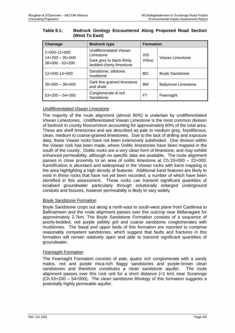
Geological maps from the GSI were reviewed to obtain an overview of the bedrock geology traversed by the proposed road alignment. The alignment predominantly transverses over Carboniferous rocks with three rock formations identified which are summarised in Table 9.1 below (Refer Figure 9.1, EIAR Volume 3).
Roughan & O’Donovan – AECOM Alliance N5 Ballaghaderreen to Scramoge Road Project Consulting Engineers Environmental Impact Assessment Report
Ref: (14.155) Page 9/5
Table 9.1: Bedrock Geology Encountered Along Proposed Road Section (West To East)
Chainage Bedrock type Formation
1+000-12+000
14+250 – 35+000
38+000 - 53+200
Undifferentiated Visean Limestone
Dark grey to black thinly bedded cherty limestone
VIS
VISoo Visean Limestone
12+000-14+500 Sandstone, siltstone, mudstone
BO Boyle Sandstone
35+000 – 38+000 Dark fine grained limestone and shale
BM Ballymore Limestone
53+200 – 54+350 Conglomerate & red Sandstone
FT Fearnaght
Undifferentiated Visean Limestone
The majority of the route alignment (almost 90%) is underlain by undifferentiated Visean Limestones. Undifferentiated Visean Limestone is the most common division of bedrock in county Roscommon accounting for approximately 60% of the total area. These are shelf limestones and are described as pale to medium grey, fossiliferous, clean, medium to coarse-grained limestones. Due to the lack of drilling and exposure data, these Visean rocks have not been extensively subdivided. One division within the Visean rock has been made, where Oolitic limestones have been mapped in the south of the county. Oolitic rocks are a very clean form of limestone, and may exhibit enhanced permeability, although no specific data are available. The route alignment passes in close proximity to an area of oolitic limestone at Ch.19+000 – 22+000. Karstification is abundant and widespread in the Visean rocks with karst mapping in the area highlighting a high density of features. Additional karst features are likely to exist in these rocks that have not yet been recorded, a number of which have been identified in this assessment. These rocks can transmit significant quantities of localised groundwater particularly through solutionally enlarged underground conduits and fissures, however permeability is likely to vary widely. Boyle Sandstone Formation
Boyle Sandstone crops out along a north-east to south-west plane from Castlerea to Ballinameen and the route alignment passes over this outcrop near Bellanagare for approximately 2.7km. The Boyle Sandstone Formation consists of a sequence of poorly-bedded, red purple pebbly grit and coarse sandstone conglomerates with mudstones. The basal and upper beds of this formation are reported to comprise reasonably competent sandstones, which suggest that faults and fractures in this formation will remain relatively open and able to transmit significant quantities of groundwater. Fearnaght Formation
The Fearnaght Formation consists of pale, quartz rich conglomerate with a sandy matrix, red and purple mica-rich flaggy sandstones and purple-brown clean sandstones and therefore constitutes a clean sandstone aquifer. The route alignment passes over this rock unit for a short distance (<1 km) near Scramoge (Ch.53+200 – 54+000). The clean sandstone lithology of this formation suggests a potentially highly permeable aquifer.
Roughan & O’Donovan – AECOM Alliance N5 Ballaghaderreen to Scramoge Road Project Consulting Engineers Environmental Impact Assessment Report
Ref: (14.155) Page 9/6
Structural Features
The regional structure of the area is influenced by three major structural events, namely the Taconic, Caledonian and Variscan Orogeies. The most recent of these geological events was the Variscan Orogeny and consisted of a north-south compression event and resulted in the folding, uplifting and block faulting with minimal metamorphism. Major faults are mapped along the Strokestown and Castlerea Inliers with the route alignment crossing these structural features at chainages 11+750, 14+250 and 53+200. Such Features can potentially represent preferential pathways for groundwater flow.
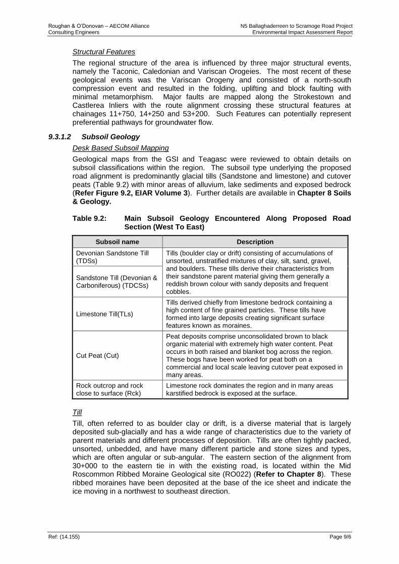
9.3.1.2 Subsoil Geology
Desk Based Subsoil Mapping
Geological maps from the GSI and Teagasc were reviewed to obtain details on subsoil classifications within the region. The subsoil type underlying the proposed road alignment is predominantly glacial tills (Sandstone and limestone) and cutover peats (Table 9.2) with minor areas of alluvium, lake sediments and exposed bedrock (Refer Figure 9.2, EIAR Volume 3). Further details are available in Chapter 8 Soils & Geology. Table 9.2: Main Subsoil Geology Encountered Along Proposed Road
Section (West To East)
Subsoil name Description
Devonian Sandstone Till (TDSs)
Tills (boulder clay or drift) consisting of accumulations of unsorted, unstratified mixtures of clay, silt, sand, gravel, and boulders. These tills derive their characteristics from their sandstone parent material giving them generally a reddish brown colour with sandy deposits and frequent cobbles.
Sandstone Till (Devonian & Carboniferous) (TDCSs)
Limestone Till(TLs)
Tills derived chiefly from limestone bedrock containing a high content of fine grained particles. These tills have formed into large deposits creating significant surface features known as moraines.
Cut Peat (Cut)
Peat deposits comprise unconsolidated brown to black organic material with extremely high water content. Peat occurs in both raised and blanket bog across the region. These bogs have been worked for peat both on a commercial and local scale leaving cutover peat exposed in many areas.
Rock outcrop and rock close to surface (Rck)
Limestone rock dominates the region and in many areas karstified bedrock is exposed at the surface.
Till
Till, often referred to as boulder clay or drift, is a diverse material that is largely deposited sub-glacially and has a wide range of characteristics due to the variety of parent materials and different processes of deposition. Tills are often tightly packed, unsorted, unbedded, and have many different particle and stone sizes and types, which are often angular or sub-angular. The eastern section of the alignment from 30+000 to the eastern tie in with the existing road, is located within the Mid Roscommon Ribbed Moraine Geological site (RO022) (Refer to Chapter 8). These ribbed moraines have been deposited at the base of the ice sheet and indicate the ice moving in a northwest to southeast direction.
Roughan & O’Donovan – AECOM Alliance N5 Ballaghaderreen to Scramoge Road Project Consulting Engineers Environmental Impact Assessment Report
Ref: (14.155) Page 9/7
The type of parent material plays a critical role in providing the particles that create different subsoil permeability, with sandstones giving rise to a high proportion of sand sized grains in the till matrix, clean limestones providing a relatively high proportion of silt, while shales, shaly limestones and mudstones break down to the finer clay sized particles. Sandstone Till (Devonian and Devonian/Carboniferous), Limestone Till (Carboniferous) and Sandstones and Shales Till (Lower Palaeozoic) are present in distinct units along the proposed road and relate to the nature of the underlying bedrock material. Coarse grained tills have a good strength with low compressibility and are therefore good for use as earthworks during the road development construction. Finer grained material has a variable strength with low to medium compressibility and can be variable regarding use as earthworks. Peat
Deposition of peat occurred in post-glacial periods associated with the start of warmer and wetter climatic conditions. Peat is an unconsolidated brown to black organic material comprising a mixture of decomposed and undecomposed plant matter that accumulated in a waterlogged environment. Peat has an extremely high water content averaging over 90% by volume. Numerous pockets of cutover peat are located along the entire length of the proposed road alignment with limited areas of raised bog in close proximity to the route. Peat soils are considered to be problematic for construction work owing to their high organic content, high compressibility and low shear strength and therefore excavation and replacement with suitable material is likely. Alluvium
There are limited alluvial sediments identified within the study area. It is expected that some alluvial sediments will be present along the main rivers traversing the alignment, namely the Carricknabraher, Owennaforeesha and Owenur, Strokestown and Scramoge. These sediments consist of unconsolidated materials of all grain sizes, from coarse gravel down to finer silts and clays, and may contain organic detritus. The deposits are usually bedded, consisting of many complex strata of waterlain material. Alluvium deposits have a poor strength and high compressibility, and are therefore considered poor material for use as earthworks during the road development construction. Lake Sediments
Lake or lacustrine deposits were formed in the quiet waters of lakes formed by the melting glacier waters. They typically consist of silty and clayey material, similar to the finer type of alluvium. Limited lake deposits have been mapped and these are located to the south and east of Strokestown. Lake deposits have a poor strength and high compressibility, and are therefore considered poor material for use as earthworks during road development construction.

Roughan & O’Donovan – AECOM Alliance N5 Ballaghaderreen to Scramoge Road Project Consulting Engineers Environmental Impact Assessment Report
Ref: (14.155) Page 9/8
Made Ground
Made ground is located in localised areas along the alignment but is not likely to be extensive. Generally where made ground is present it is associated with urban developments within the vicinity of the alignment including Frenchpark, Bellanagare and Strokestown and at the locations of existing roads which are crossed by the route.
9.3.1.3 Aquifer Classification
The GSI has classified geological strata for hydrogeological purposes based on the value of the groundwater resource and the hydrogeological characteristics. There are 3 principal types of aquifer, corresponding to whether they are major, minor or unproductive groundwater resources. These are further subdivided into 10 aquifer categories (DELG/EPA/GSI, 1999) (Table 9.3). Table 9.3: Aquifer Types
Aquifer Type Description Code
Regionally Important (R)
Karstified bedrock dominated by diffuse flow (Rkd)
Karstified bedrock dominated by conduit flow (Rkc)
Fissured bedrock (Rf)
Extensive sand & gravel (Rg)
Locally Important (L)
Sand and gravel (Lg)
Bedrock which is Generally Moderately Productive (Lm)
Bedrock which is Moderately Productive only in Local Zones (Ll)
Locally important karstified bedrock (Lk)
Poor (P)
Bedrock which is Generally Unproductive except for Local Zones
(Pl)
Bedrock which is Generally Unproductive (Pu)
There are 3 aquifer classes traversed by the proposed road alignment with the majority (89% of the road length) lying within a Regionally Important Karstified Aquifer, dominated by conduit flow (Rkc) (Table 9.4) (Refer Figure 9.3, EIAR Volume 3). The aquifer types that are encountered from west to east along the proposed road are summarised in Table 9.5 below. Table 9.4: Aquifer Types Underlain By Proposed Road Alignment
Aquifer Type Description Code
Regionally Important Karstified bedrock dominated by conduit flow Rkc
Locally Important
Bedrock which is generally moderately productive
Bedrock which is moderately productive only in local zones
Lm
LI
Table 9.5: Location Of Aquifer Types Along Proposed Road Alignment
Section Approximate Chainage Length Aquifer Type
A 1+000 – 5+697 4.7 km RKc
B 10+000 – 11+950
14+500 – 24+200 11.65 km RKc

Roughan & O’Donovan – AECOM Alliance N5 Ballaghaderreen to Scramoge Road Project Consulting Engineers Environmental Impact Assessment Report
Ref: (14.155) Page 9/9
Section Approximate Chainage Length Aquifer Type
B 11+950 – 14+200 2.25 km LI
C 30+000 – 40+542 10.54 km RKc
D 50+000 – 53+200 3.2 km RKc
D 53+200 – 53+970 0.8 Km Lm
A summary of the main characteristics is provided by the GSI in its aquifer classification process and this is detailed below in Table 9.6. Table 9.6: Typical Characteristics For Aquifers In Study Area
Aquifer property Aquifer Type
Rkc Lm Ll
Transmissivity Variable; can range from 15 - 1000m
2/d
with higher values possible
No information available.
Variable: reported as 2-76m
2/d in sandstones
and 5-10 m2/d in
limestones; enhanced zones occurring locally
Productivity Highly productive with high yielding springs
High productivity likely. Moderate to low.
Borehole yields High & Intermediate yielding springs 1100 - 7000 m
3/d
No information available.
No information available.
Potential extent of flow systems
Regional – long flow paths >1km
Regional/local – flow paths can be >1km
Local – Flow paths short (30-300m)
Large springs Yes Potential Unlikely
Lithology Dinantian Pure Bedded Limestones and abundant karst features
Dinantian Sandstones Dinantian mixed sandstones, Shales, & limestones
Structural geology Major fault along NW boundary; dips
generally <10 - steeper near faults
Faulted bounded inlier; NW/SE cross cutting trending faults
Faulted bounded inlier; NE/SW with parallel faulting
Surface water groundwater interaction
High degree of interconnection with numerous karst features
Moderate interconnection. Groundwater discharging to rivers/streams
Likely to be low given low permeability characteristics
Groundwater Flow/aquifer thickness
Most GW flow in upper epikarst and zone of interconnected solutionally enlarged fissures/conduits; generally not extending > 30m
GW within the weathered zone and upper interconnected zone extending to < 30m
Most GW flow within upper weathered zone of interconnected fissures not likely to extend more than 15m
Annual fluctuation in water levels
Highly variable 1 – 2m reported at the Castlerea springs
No criteria
Note: Productivity class I implies that significant quantities of water can be abstracted with little consequent drawdown in the groundwater table, and class V indicates that the drawdown can be significant for a given abstraction rate

Roughan & O’Donovan – AECOM Alliance N5 Ballaghaderreen to Scramoge Road Project Consulting Engineers Environmental Impact Assessment Report
Ref: (14.155) Page 9/10
9.3.2 Groundwater Bodies
The Water Framework Directive (WFD) provides for the protection, improvement and sustainable use of waters, including rivers, lakes, coastal waters, estuaries and groundwater within the EU Member States. It aims to prevent deterioration of these water bodies and enhance the status of aquatic ecosystems; promote sustainable water use; reduce pollution; and contribute to the mitigation of floods and droughts. Under the Water Framework Directive large geographical areas of aquifer have been subdivided into smaller groundwater bodies (GWB) in order for them to be effectively managed. There are 5 separate hydrogeologically defined GWB traversed by the proposed road alignment as shown in Table 9.7 below. (Refer Figure 9.4, EIAR Volume 3). Table 9.7: GWB Traversed By Proposed Road Alignment
WFD GWD Code Chainage Status
Carrick on Shannon IE_SH_G_048 1+000 – 3+400
14+250 – 53+150 Poor (at Risk)
Carrick on Shannon 4 IE_SH_G_067 3+400 – 11+600 Poor (at Risk)
Castlerea Bellanagare 1 IE_SH_G_068 11+600 – 14+250 Good
Scramoge North IE_SH-G_201 53+150 – 54+000 Good
Scramoge South IS_SH_G_202 54+000 – 54+350 Good
According to interim classification work carried out as part of the Water Framework Directive, the Castlerea Bellanagare 1 and Scramoge North & South GWB’s are classified as having good status in terms of quality and quantity. The overall risk result of 2a Probably Not At Risk is applied to Castlerea Bellanagare GWB while a risk status of 2b Not at Risk is applied to Scramoge. The objective for these GWB’s is to Maintain their good status. The Carrick on Shannon GWB is classified as having poor status and is assigned an overall risk result of 1a At Risk. The objective for this GWB is to Restore to good status by 2021. Given that the proposed road realignment predominantly passes through the Carrick on Shannon GWB, there is the potential to impact water quality and groundwater flows and particular care is therefore required. For the purpose of this assessment, aquifer characteristics have been considered for each GWB traversed by the proposed road alignment. The descriptions have been taken from the GSI ‘Summary of Initial Characterisation’ draft reports for each hydrogeologically defined groundwater body. Site specific data including depth to bedrock and subsoil type, collated during the work for this road development has been used to supplement and validate the general information.
9.3.2.1 Carrick on Shannon GWB
The Carrick on Shannon GWB is characterised with widespread Karstification. This karstification results in groundwater flow through a network of solution enlarged conduits which result in a highly permeable aquifer with rapid groundwater flow. As a result of the karstification there is a wide range of permeabilities and transmissivities reported within the GWB. Tracer tests carried out in the area reported rapid velocities and flow paths potentially several kilometres in length. Most of the groundwater flow is expected to take place within the upper epikarstic layers (weathered bedrock) and a zone of interconnected solutionally enlarged fissures (conduits) beneath this to a depth of c. 30m below ground level (bgl). The groundwater body supports high to intermediate springs in the area including the

Roughan & O’Donovan – AECOM Alliance N5 Ballaghaderreen to Scramoge Road Project Consulting Engineers Environmental Impact Assessment Report
Ref: (14.155) Page 9/11
Peak/Mantua spring supply source. There is a high degree of surface water/groundwater interconnection with numerous karst features such as Turloughs, swallow holes, springs, dolines and caves. Groundwater flow is variable depending on the topography and karst nature of the GWB.
9.3.2.2 Castlerea GWB
The Castlerea GWB is characterised by unconfined aquifer composed in mainly low permeability rocks which have local zones of enhanced permeability. The GWB is made up of locally important aquifers (LI) with transmissivities ranging from 2-76m2/d within the sandstones and 5-10m2/d within the impure limestones. Groundwater flow is predominantly within the upper 15m consisting of the upper weathered horizon and a connected fracture zone below this. Deeper flow is reported in areas of deformation and faulting. Groundwater flow paths are generally short and less than 300m with flow directions influenced by local topography.
9.3.2.3 Scramoge North GWB
The Scramoge GWB is made up of the Fearnaght sandstones with flow concentrated in the fractured and weathered zones. Given the lithology of the GWB, permeability / transmissitivies are expected to be high. As with the other GWB, the groundwater flow is mainly within the upper 30m of the bedrock within the weathered horizon and zone of interconnected fissures. Regionally groundwater flow is expected to be a northwesterly direction with flow paths ranging from 500-2000m in length.
9.3.2.4 Scramoge South GWB
This GWB is similar to the Scramoge North GWB being made up of Fearnaght Sandstones. The dominant sandstone lithology gives rise to higher permeabilities and degree of interconnection. Groundwater flow is expected mainly within the upper 30m of the bedrock. Regional groundwater flow reflects topography, flowing in a southeast direction. Given the permeability characteristics groundwater is expected to discharge to surface waters so locally flowing towards rivers and streams. Flow paths are expected to range from local to regional scale (up to 500-2000m).
9.3.3 Groundwater Vulnerability
The risk to groundwater is defined through assessments of groundwater vulnerability, aquifer potential and source protection areas. Groundwater vulnerability represents the intrinsic geological and hydrogeological characteristics that determine the ease with which groundwater may be contaminated by human activities. It depends on the travel time of infiltrating water (and contaminants), the amount of contaminants that can reach groundwater and the contaminant attenuating capacity of the geological materials through which the water and contaminants infiltrate. The final groundwater vulnerability rating is determined by both the thickness of the unsaturated subsoil which the contaminants move through and the attributes of the overlying subsoil and more specifically the subsoil permeability (DELG/EPA/GSI, 1999). The nature of groundwater recharge (point or diffuse) and how readily water is received also influences the final vulnerably rating of an area. Areas where water (and contaminants) can quickly move from the land surface to groundwater are deemed to be more vulnerable and in that regard groundwater vulnerability is primarily dependant on the permeability and depth of the overburden. The GSI guidelines given in their Groundwater Protection Schemes (DELG/EPA/GSI, 1999) can be combined with site investigation data (geological and hydrogeological characteristics) to obtain appropriate vulnerability ratings for the ground along the proposed road alignment. Four groundwater vulnerability categories are defined: extreme (E), high (H), moderate (M) and low (L). A subset of the ‘extreme’ category

Roughan & O’Donovan – AECOM Alliance N5 Ballaghaderreen to Scramoge Road Project Consulting Engineers Environmental Impact Assessment Report
Ref: (14.155) Page 9/12
is termed the ‘X – extreme’ category, and relates to areas of bedrock outcrop or subcrop (<1m), or within 30m of a location of point recharge (i.e. karst feature). Table 9.8 outlines the geological and hydrogeological characteristics which determine the vulnerability of an area. Table 9.8: Groundwater Vulnerability Mapping Guidelines
Vulnerability Rating
Hydrogeological Conditions
Subsoil Permeability (Type) and Thickness Unsaturated
Zone Karst
Features
High permeability (sand/gravel)
Moderate permeability (e.g. Sandy
subsoil)
Low permeability (e.g. Clayey
subsoil, clay, peat)
(Sand/gravel aquifers
only)
(< 30m radius)
Extreme (E) 0 – 3.0m 0 – 3.0m 0 – 3.0m 0 – 3.0m n/a
High (H) > 3.0m 3.0 – 10.0m 3.0 – 5.0m > 3.0m n/a
Moderate (M) n/a > 10.0m 5.0 – 10.0m n/a n/a
Low (L) n/a n/a > 10.0m n/a n/a
n/a = not applicable.
Precise permeability values cannot be given at present.
Release point of contaminants is assumed to be 1-2m below ground surface.
The GSI mapping indicates the vulnerability of the groundwater closest to the ground surface from contaminants assumed to be released 1m to 2m below the ground surface. Vulnerability mapping is used for guidance only and should be supported by site investigation data and contaminant specific assessments where appropriate. In this regard a detailed programme of ground investigations has been undertaken along the proposed road development allowing the site specific vulnerability to be determined. In unsaturated bedrock aquifers the target for protection is the groundwater table within the bedrock unit, and for saturated aquifers it is the top of the bedrock. In karst areas groundwater is particularly vulnerable to contamination with an extreme rating as:
water ingress can be rapid through solution enlarged fissures
sinking streams enable direct entry of water with little or no attenuation of contaminants
karst features such as dolines can provide direct water entry routes through vertical shafts
soil cover over karst limestone tends to be minimal or absent and so provides little or no protection (GSI, 2002).
9.3.3.1 Vulnerability Mapping Along the Proposed Road Development
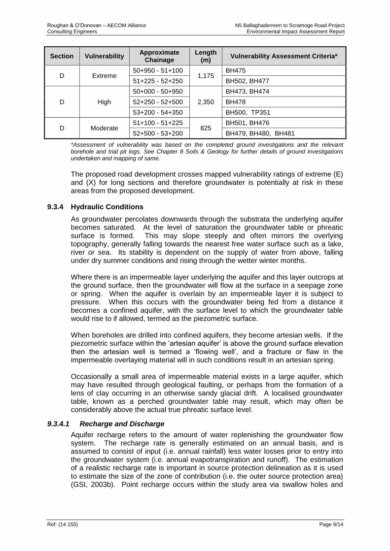
The vulnerability mapping for County Roscommon is available from the GSI website and GIS datasets. The road alignment traverses all of the vulnerability ratings outlined in Table 9.8 above (Refer Figure 9.4, EIAR Volume 3). The ground investigations completed to date allow a site specific assessment of groundwater vulnerability to be undertaken along the proposed road development in accordance with Table 9.8 above. The resulting vulnerabilities are given in Table 9.9 along each of the sections of the road alignment. For the purposes of developing Table 9.9, changes in vulnerability occurring for lengths of less than 50m were ignored.

Roughan & O’Donovan – AECOM Alliance N5 Ballaghaderreen to Scramoge Road Project Consulting Engineers Environmental Impact Assessment Report
Ref: (14.155) Page 9/13
Table 9.9: Vulnerability Mapping Along the Proposed Road Development
Section Vulnerability Approximate
Chainage Length
(m) Vulnerability Assessment Criteria*
A Extreme
1+000 - 1+400
3,800
TP301
1+650 - 4+250 TP302, TP303, BH401A.1, BH 403, BH 401B, TP305, TP315, BH 402, BH 403, TP306
4+600 - 5+400 TP309
A High 1+400 - 1+650
600 TP301A
4+250 - 4600 BH405
A Moderate 5+400 - 5+698 298 BH 407
B Extreme
10+700 - 10+900
4,100
BH479B
12+450 - 14+250 TP311A, BH 483A, BH 418, TP313, BH 419, BH 420, TP314, BH 420A
19+200 - 21+300 BH431A, BH432, BH433, BH434, BH434A
B High
10+100 - 10+700
6,250
BH409, BH479A
11+950 - 12+450 BH482, BH 483
14+500 - 14+950 BH422, BH423
15+650 - 16+150 BH425, BH425B
17+200 - 19+200 TP318, TP364, BH428, BH428A, BH430, BH430B
21+300 - 21+850 BH434B
22+150 - 23+800 BH435A, BH436
B Moderate
10+000 - 10+100
3,800
BH408
10+900 - 11+950 BH479C, BH480E, BH480A, BH 481B, BH 480D, BH 481, BH 481A
14+250 - 14+500 BH421
14+950 - 15+650 BH423A, BH424
16+150 - 17+200 BH425A, BH426
21+850 - 22+150 BH435
23+800 - 24+150 Bh437
C Extreme
33+450 - 34+950
8,050
BH451, BH491, BH486, BH504
31+100 - 37+250 BH485, BH44, BH459, BH459A, BH460
39+450 - 39+850 BH471
C High
30+000 - 30+500
10,043
BH437C
31+550 - 33+450 BH442. BH445, BH447, BH448, BH449, BH450
34+950 - 36+100 BH 489, BH 445, BH458
37+250 - 37+700 BH461, BH462, BH464, BH464A, BH464B
39+100 - 39+450 BH469,
39+850 - 45+543 BH472, BH473
C Moderate 30+500 - 31+550
2,450 BH438, BH440
37+700 - 39+100 BH466
Roughan & O’Donovan – AECOM Alliance N5 Ballaghaderreen to Scramoge Road Project Consulting Engineers Environmental Impact Assessment Report
Ref: (14.155) Page 9/14
Section Vulnerability Approximate
Chainage Length
(m) Vulnerability Assessment Criteria*
D Extreme 50+950 - 51+100
1,175 BH475
51+225 - 52+250 BH502, BH477
D High
50+000 - 50+950
2,350
BH473, BH474
52+250 - 52+500 BH478
53+200 - 54+350 BH500, TP351
D Moderate 51+100 - 51+225
825 BH501, BH476
52+500 - 53+200 BH479, BH480, BH481
*Assessment of vulnerability was based on the completed ground investigations and the relevant borehole and trial pit logs. See Chapter 8 Soils & Geology for further details of ground investigations undertaken and mapping of same.
The proposed road development crosses mapped vulnerability ratings of extreme (E) and (X) for long sections and therefore groundwater is potentially at risk in these areas from the proposed development.
9.3.4 Hydraulic Conditions
As groundwater percolates downwards through the substrata the underlying aquifer becomes saturated. At the level of saturation the groundwater table or phreatic surface is formed. This may slope steeply and often mirrors the overlying topography, generally falling towards the nearest free water surface such as a lake, river or sea. Its stability is dependent on the supply of water from above, falling under dry summer conditions and rising through the wetter winter months. Where there is an impermeable layer underlying the aquifer and this layer outcrops at the ground surface, then the groundwater will flow at the surface in a seepage zone or spring. When the aquifer is overlain by an impermeable layer it is subject to pressure. When this occurs with the groundwater being fed from a distance it becomes a confined aquifer, with the surface level to which the groundwater table would rise to if allowed, termed as the piezometric surface. When boreholes are drilled into confined aquifers, they become artesian wells. If the piezometric surface within the ‘artesian aquifer’ is above the ground surface elevation then the artesian well is termed a ‘flowing well’, and a fracture or flaw in the impermeable overlaying material will in such conditions result in an artesian spring. Occasionally a small area of impermeable material exists in a large aquifer, which may have resulted through geological faulting, or perhaps from the formation of a lens of clay occurring in an otherwise sandy glacial drift. A localised groundwater table, known as a perched groundwater table may result, which may often be considerably above the actual true phreatic surface level.
9.3.4.1 Recharge and Discharge
Aquifer recharge refers to the amount of water replenishing the groundwater flow system. The recharge rate is generally estimated on an annual basis, and is assumed to consist of input (i.e. annual rainfall) less water losses prior to entry into the groundwater system (i.e. annual evapotranspiration and runoff). The estimation of a realistic recharge rate is important in source protection delineation as it is used to estimate the size of the zone of contribution (i.e. the outer source protection area) (GSI, 2003b). Point recharge occurs within the study area via swallow holes and
Roughan & O’Donovan – AECOM Alliance N5 Ballaghaderreen to Scramoge Road Project Consulting Engineers Environmental Impact Assessment Report
Ref: (14.155) Page 9/15
collapse features associated with the karstified limestone. Diffuse recharge occurs over the entire area via rainfall percolating through the subsoil. There are two Met Éireann synoptic weather stations in the vicinity of the study area located at Claremorris to the west and Mount Dillion, Lanesborough to the east. Climate averages are computed over a 30 year period of consecutive records with this time period considered long enough to smooth out year to year variations. Met Éireann currently reference 1981 to 2010 as the baseline period for day-to-day weather and climate comparisons. However due to gaps in data availability at Claremorris synoptic station during that period complete data is available for the period 1971-2000. Data was only available from 2007 onwards at Mount Dillion in Lanesborough and is therefore insufficient for averaging purposes. The mean annual rainfall at Claremorris for the 1971 to 2000 period was 1173.6mm per annum. The mean annual potential evapotranspiration (PE) rate for the period 1971 – 1995 (1971-2000 data not available) is given as 461.6mm per annum, with the actual evapotranspiration estimated at about 95% of the PE. The GSI has produced detailed recharge mapping for the country based largely on the thickness and permeability of subsoil cover and effective rainfall for an area. This mapping gives an estimate of the likely proportion of effective rainfall that will reach groundwater as recharge. Due to the limited permeability and available storage within certain bedrock units, some of the infiltrating water may be rejected due to the rock not being capable of receiving it and in these areas recharge caps have been assigned. It must be noted that actual annual recharge to groundwater depends on the site specific subsoil infiltration rates and the proportion of surface runoff. Figure 9.6 (EIAR Volume 3) illustrates groundwater recharge conditions across the study area. Areas of peat have been assigned an extremely low recharge coefficient of 4% due to their poor permeability. The majority of the route alignment is estimated to have a recharge coefficient of 22.5% which is relatively low due to the poorly draining limestone tills (high clay/ silt content) present. Actual recharge to the karstified aquifer is likely to be far higher due to the presence of numerous karst features which will provide point recharge to groundwater, particularly through enclosed depressions or dolines which tend to funnel surface runoff into areas where bedrock is connected hydraulically to the surface. There are many recorded groundwater springs and seepages that maintain base flows in the streams and rivers through point sources at the head and within the watercourse. Due to the high karstification in the area there is significant interaction between groundwater and surface water flows. The Scramoge River is a noted losing river during dry flow conditions with water seeping through the Limestone river bed to the aquifer.
9.3.5 Karst Landscape and Features
9.3.5.1 Karst Landscape
Karst is a term used to describe the distinctive landforms that develop on rock types that are readily dissolved by water. In Ireland, limestone (composed of calcium carbonate) and to a lesser extent dolomite (calcium and magnesium carbonate) are by far the most widespread rocks that show karst features. Rain water is slightly acidic and can readily dissolve limestone rock. In addition when rainwater passes through soil material before reaching the limestone rock, it becomes more acidic and can dissolve the rock more readily. As the acidic water passes down through cracks in the limestone it enlarges them by dissolving the rock and thus allows a greater quantity of water to enter and eventually fissures are formed. Over time these fissures are further enlarged to form conduits or large cave systems. These underground passages can become large enough to allow all rainwater from an area to be engulfed into the rock extremely quickly. The terrain of a karst landscape may
Roughan & O’Donovan – AECOM Alliance N5 Ballaghaderreen to Scramoge Road Project Consulting Engineers Environmental Impact Assessment Report
Ref: (14.155) Page 9/16
be pitted with deep conical or saucer shaped hollows some of which can be very large. These small to medium sized enclosed depressions or dolines correspond to collapsed underground features. Dolines often collect rainwater and channel it very quickly underground. Once underground, water flowing in small fissures and cracks can combine to form small streams, which can expand further into large underground rivers. These underground waters will, at some point, return to the surface as springs and seepages or in some areas may discharge directly to the coast. Rivers can also originate in non-limestone bedrock areas, flow into a limestone region and then immediately sink underground through swallow holes. Areas of karst can be identified by a general absence of permanent surface water features. In addition the presence of characteristic surface terrain features will dominate a karst landscape. In that regard the presence of swallow holes and enclosed depressions, springs, caves, dry valleys and Turloughs will identify a region as karst.
9.3.5.2 Implications for Road Developments
Karst regions may provide particular problems for engineering works associated with major road and bridge construction. These problems mainly arise from the unpredictable occurrence, extent and depth of underground cavities which may lead to subsequent road subsidence and inadequate foundation support for bridge structures. An important feature of karst areas is the absence of surface water which often leads to groundwater being the main source of supply (GSI, 2002). The presence of private well supplies in the vicinity of the road development have an increased risk to contamination from road runoff and from constructional activities due to the potential preferential flows within the Karst that may currently exist or develop over time.
9.3.5.3 Karst Features Along the Route
County Roscommon has a high level of Karstification with numerous karst features identified along the proposed road development (Refer Figure 9.4, EIAR Volume 3). The area is low-lying and overlain by glacial till deposits. These deposits generally cover the karstic nature of the underlying bedrock, however bedrock is exposed in many areas. Specific karst mapping has been carried out for the entire route (Refer Figure 9.5 – 9.10, EIAR Volume 3). This mapping was compiled following a review of: aerial photography, the GSI karst database, walkover surveys of identified sites, local anecdotal information and preliminary site investigation results. It is important to note that there are likely to be further unmapped features present on the ground, as well as unseen underground features. There are six areas along the route alignment where clusters of karst features are encountered either along the alignment or in close proximity – see Figure 9.3 in EIAR Volume 3. In these areas the road construction may interact with complex hydrogeological flow regimes. 1. Churchstreet/ Portaghard (Ch. 3+450 – Ch. 4+100)
A number of depressional features, related to the underlying karst bedrock, are located in the vicinity of Churchstreet/Portaghard between chainages 3+450 – 4+100. These features act as drainage for surrounding lands discharging directly to the bedrock. During extreme rainfall events, localised ponding at these features occurs (winter pluvial flooding), which then drains slowly through these features to bedrock. The proposed road alignment does not pass in close proximity to these depressional (karst) features.
Roughan & O’Donovan – AECOM Alliance N5 Ballaghaderreen to Scramoge Road Project Consulting Engineers Environmental Impact Assessment Report
Ref: (14.155) Page 9/17
2. Leggatinty (Ch. 10+000 – Ch. 14+000)
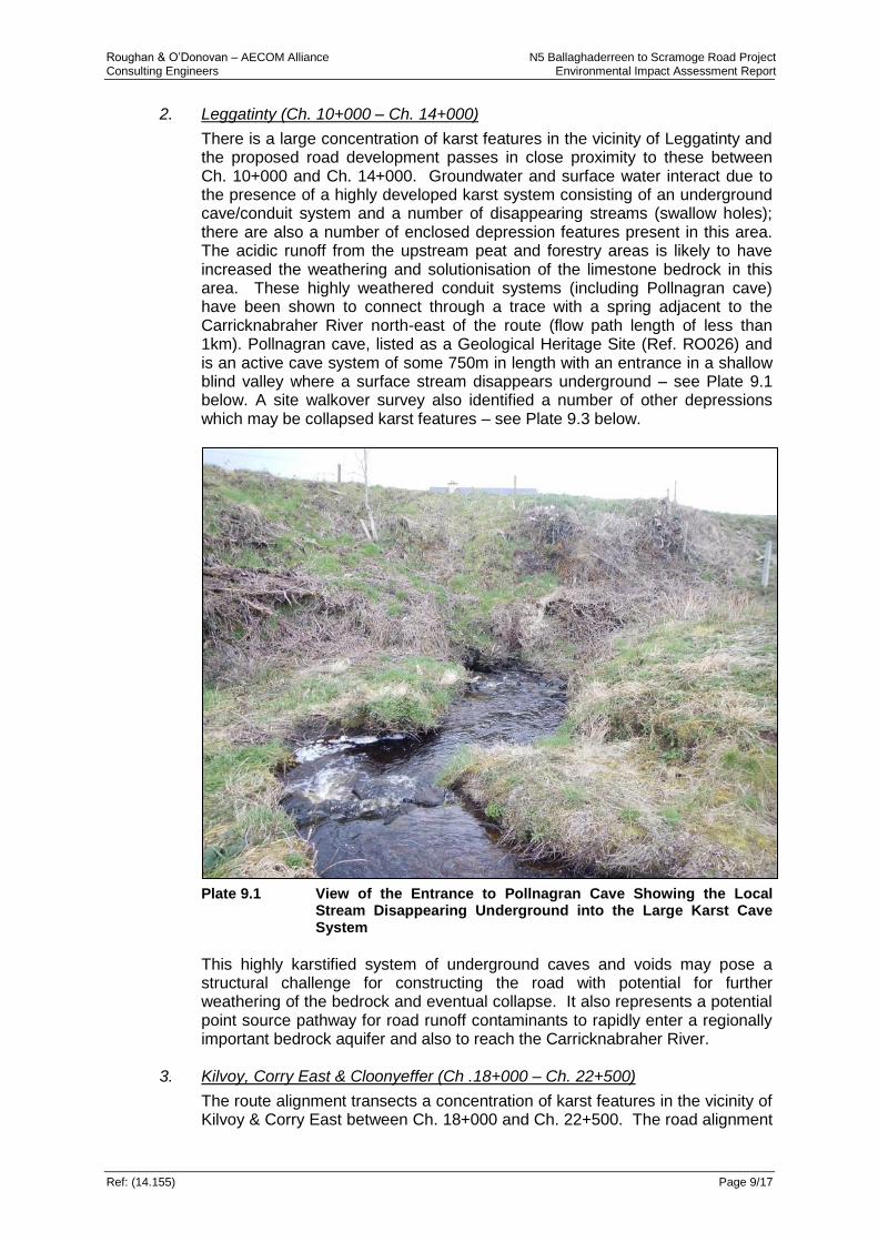
There is a large concentration of karst features in the vicinity of Leggatinty and the proposed road development passes in close proximity to these between Ch. 10+000 and Ch. 14+000. Groundwater and surface water interact due to the presence of a highly developed karst system consisting of an underground cave/conduit system and a number of disappearing streams (swallow holes); there are also a number of enclosed depression features present in this area. The acidic runoff from the upstream peat and forestry areas is likely to have increased the weathering and solutionisation of the limestone bedrock in this area. These highly weathered conduit systems (including Pollnagran cave) have been shown to connect through a trace with a spring adjacent to the Carricknabraher River north-east of the route (flow path length of less than 1km). Pollnagran cave, listed as a Geological Heritage Site (Ref. RO026) and is an active cave system of some 750m in length with an entrance in a shallow blind valley where a surface stream disappears underground – see Plate 9.1 below. A site walkover survey also identified a number of other depressions which may be collapsed karst features – see Plate 9.3 below.
Plate 9.1 View of the Entrance to Pollnagran Cave Showing the Local
Stream Disappearing Underground into the Large Karst Cave System
This highly karstified system of underground caves and voids may pose a structural challenge for constructing the road with potential for further weathering of the bedrock and eventual collapse. It also represents a potential point source pathway for road runoff contaminants to rapidly enter a regionally important bedrock aquifer and also to reach the Carricknabraher River.
3. Kilvoy, Corry East & Cloonyeffer (Ch .18+000 – Ch. 22+500)
The route alignment transects a concentration of karst features in the vicinity of Kilvoy & Corry East between Ch. 18+000 and Ch. 22+500. The road alignment
Roughan & O’Donovan – AECOM Alliance N5 Ballaghaderreen to Scramoge Road Project Consulting Engineers Environmental Impact Assessment Report
Ref: (14.155) Page 9/18
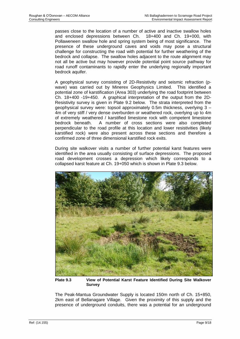
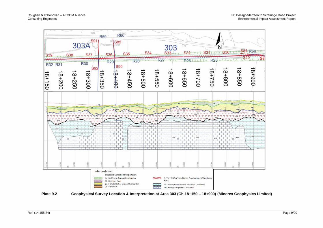
passes close to the location of a number of active and inactive swallow holes and enclosed depressions between Ch. 18+400 and Ch. 19+000, with Pollaweneen swallow hole and spring system being of most significance. The presence of these underground caves and voids may pose a structural challenge for constructing the road with potential for further weathering of the bedrock and collapse. The swallow holes adjacent to the route alignment may not all be active but may however provide potential point source pathway for road runoff contaminants to rapidly enter the underlying regionally important bedrock aquifer. A geophysical survey consisting of 2D-Resistivity and seismic refraction (p-wave) was carried out by Minerex Geophysics Limited. This identified a potential zone of karstification (Area 303) underlying the road footprint between Ch. 18+400 -19+450. A graphical interpretation of the output from the 2D-Resistivity survey is given in Plate 9.2 below. The strata interpreted from the geophysical survey were: topsoil approximately 0.5m thickness, overlying 3 – 4m of very stiff / very dense overburden or weathered rock, overlying up to 4m of extremely weathered / karstified limestone rock with competent limestone bedrock beneath. A number of cross sections were also completed perpendicular to the road profile at this location and lower resistivities (likely karstified rock) were also present across these sections and therefore a confirmed zone of three dimensional karstified rock exits. During site walkover visits a number of further potential karst features were identified in the area usually consisting of surface depressions. The proposed road development crosses a depression which likely corresponds to a collapsed karst feature at Ch. 19+050 which is shown in Plate 9.3 below.
Plate 9.3 View of Potential Karst Feature Identified During Site Walkover
Survey
The Peak-Mantua Groundwater Supply is located 150m north of Ch. 15+850, 2km east of Bellanagare Village. Given the proximity of this supply and the presence of underground conduits, there was a potential for an underground
Roughan & O’Donovan – AECOM Alliance N5 Ballaghaderreen to Scramoge Road Project Consulting Engineers Environmental Impact Assessment Report
Ref: (14.155) Page 9/19
connection between this area of karst and the supply. This water supply consists of a spring source supplying 84 households. Given the proximity of the road development to the spring there is potential for water quality and well yield impacts should the road alignment be located within the recharge zone of the spring. The potential impacts of the road development on this group water scheme (GWS) are discussed in detail in Section 9.3.6. During preliminary site investigations a borehole was drilled close to Ch. 20+450 (BH434). Voids and discontinuities were encountered at this location with a local solutionally weathered zone reported. Core recovery is a measure of how much rock has been lost during drilling. Core loss can be attributed to the presence of an open cavity or the washout of weak zones by the drilling flush. The presence of cavities or weak zones can also be identified in the drilling process when sudden increases in the advance rate occur. Core loss was recorded at BH434 at three depths below ground level; 9.09-9.83m, 10.0-10.88m, 11.50-11.81m. Given the karst nature of the bedrock at this location, it is likely that these core losses correspond to cavities or fractures in the rock. A known karst feature is located adjacent (c.65m) to the proposed road development at Ch. 20+450 in the townland of Cloonyeffer. This karst feature consists of a sinking stream which drains into a pond with no apparent outlet.
Roughan & O’Donovan – AECOM Alliance N5 Ballaghaderreen to Scramoge Road Project Consulting Engineers Environmental Impact Assessment Report
Ref: (14.155.24) Page 9/20
Plate 9.2 Geophysical Survey Location & Interpretation at Area 303 (Ch.18+150 – 18+900) (Minerex Geophysics Limited)
Roughan & O’Donovan – AECOM Alliance N5 Ballaghaderreen to Scramoge Road Project Consulting Engineers Environmental Impact Assessment Report
Ref: (14.155.24) Page 9/21
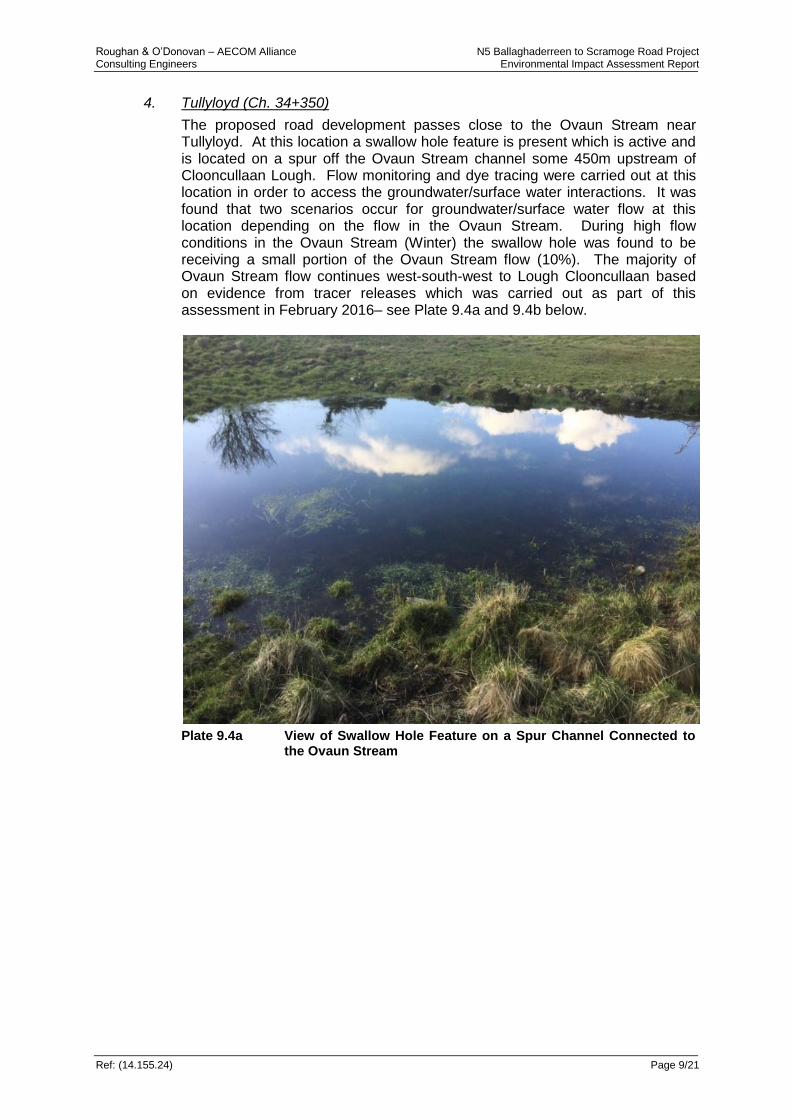
4. Tullyloyd (Ch. 34+350)
The proposed road development passes close to the Ovaun Stream near Tullyloyd. At this location a swallow hole feature is present which is active and is located on a spur off the Ovaun Stream channel some 450m upstream of Clooncullaan Lough. Flow monitoring and dye tracing were carried out at this location in order to access the groundwater/surface water interactions. It was found that two scenarios occur for groundwater/surface water flow at this location depending on the flow in the Ovaun Stream. During high flow conditions in the Ovaun Stream (Winter) the swallow hole was found to be receiving a small portion of the Ovaun Stream flow (10%). The majority of Ovaun Stream flow continues west-south-west to Lough Clooncullaan based on evidence from tracer releases which was carried out as part of this assessment in February 2016– see Plate 9.4a and 9.4b below.
Plate 9.4a View of Swallow Hole Feature on a Spur Channel Connected to
the Ovaun Stream

Roughan & O’Donovan – AECOM Alliance N5 Ballaghaderreen to Scramoge Road Project Consulting Engineers Environmental Impact Assessment Report
Ref: (14.155.24) Page 9/22
Plate 9.4b Dye Plume Released 11 Feb 2016 Remaining in the Ovaun
Stream Continuing Towards Lough Clooncullaan and Bypassing the Spur Channel to the Swallow-Hole
The area was revisited in late April 2016 and a reversal in flow conditions was observed. Low flow conditions were present in the Ovaun Stream (Summer) and the majority (90%) of the stream flow was discharging into the swallow hole with the remainder of the flow continuing on to Lough Clooncullan. In order to fully access the impacts of the proposed development, a tracer test was carried out at this location in May 2016. The tracer study was carried out following consultations with the GSI groundwater division and with their support. Fluorescein dye was released at this swallow hole feature on the 12th of May 2016 with 9 separate monitoring locations put in place at the likely downstream outflow locations. Downstream monitoring locations included: the Polecat spring GWS, Annaghmore Lough inflow stream/drain (spring-fed) and downstream locations on the Owenure River. The fluorescein dye was found in the Owenur River at Drummullin Bridge on the 26th of May 2016. The dye was not found at any other monitoring locations. The resulting trace line is shown in Plate 9.5 below as recorded by the GSI. The dye was not found at Ballyslish Bridge on the Owenur upstream of Drummullin. It was therefore concluded that the swallow hole is discharging water underground to a spring (or springs/seepages) located on or adjacent to the Owenur River between Ballyslish and Drummullin Bridges. A number of springs are indicated adjacent to the Owenur River at Creeve and it is likely that this is the location to which the Tullyloyd swallow hole is discharging.

Roughan & O’Donovan – AECOM Alliance N5 Ballaghaderreen to Scramoge Road Project Consulting Engineers Environmental Impact Assessment Report
Ref: (14.155.24) Page 9/23
Plate 9.5 Latest Karst Traced Underground Connection Map Published by
the GSI (GSI, August 2016). The Roughan & O’Donovan Trace Line is Shown from the Tulyloyd Swallow Hole to Drummullin (Not to Scale).
5. Cregga (Ch. 35+500 – Ch. 37+500)
A Turlough is located at Cregga (see Plate 9.6 & Plate 9.7a/b) and a number of karst features are also recorded in the area. A Turlough or Karst lake is a wetland at the interface between groundwater and surface water and is a characteristic feature of the Irish karst landscape. Turloughs are transient lakes that occur in topographic depressions of karstified limestone areas due to high groundwater levels as a result of high rainfall levels. Turloughs give rise to Groundwater Dependent Terrestrial Ecosystem (GWDTE) and provide a habitat for many floral and faunal species. The Turlough at Cregga appears to have two visible direct bedrock/groundwater outlets which are enlarged (see Plate 9.7a), however during a site walkover it was noted that almost the entire base area of the Turlough is directly on the limestone bedrock itself and therefore the discharge to groundwater is diffuse over a large area. The Turlough fills during the Autumn/Winter months and remains inundated with water for a significant portion of the year. The primary outlet from the Turlough is direct to bedrock groundwater at its base however there is also one high level surface water outlet. During particularly high water levels in the Turlough, water can overflow through a pipe under the R368 to a surface drain that eventually discharges to Annaghmore Lough which is a European Designated Site – see Plate 9.7b. A detailed assessment of the Turlough has been carried out by Roger Goodwillie & Associates and this is given in Appendix 7.3.
Swallow hole at Tulyloyd
Drummullin Bridge (Owenur River)
Ballyslish Bridge
Springs located in these areas

Roughan & O’Donovan – AECOM Alliance N5 Ballaghaderreen to Scramoge Road Project Consulting Engineers Environmental Impact Assessment Report
Ref: (14.155.24) Page 9/24
Plate 9.6 View of the Turlough at Cregga Looking South-west Showing
Seasonal Flooding
Plate 9.7a View of the Two Visible Turlough Outlets at Cregga During a Dry
Period. (It Must be Noted that Bedrock is at, or Close to, the Ground Surface Over the Base of the Entire Turlough Area and Therefore Groundwater Can Enter Bedrock Diffusely Over a Large Area).
Plate 9.7b Overflow from Cregga Turlough Under the R368 to the Surface
Drain that Eventually Discharges to Annaghmore Lough
Roughan & O’Donovan – AECOM Alliance N5 Ballaghaderreen to Scramoge Road Project Consulting Engineers Environmental Impact Assessment Report
Ref: (14.155.24) Page 9/25
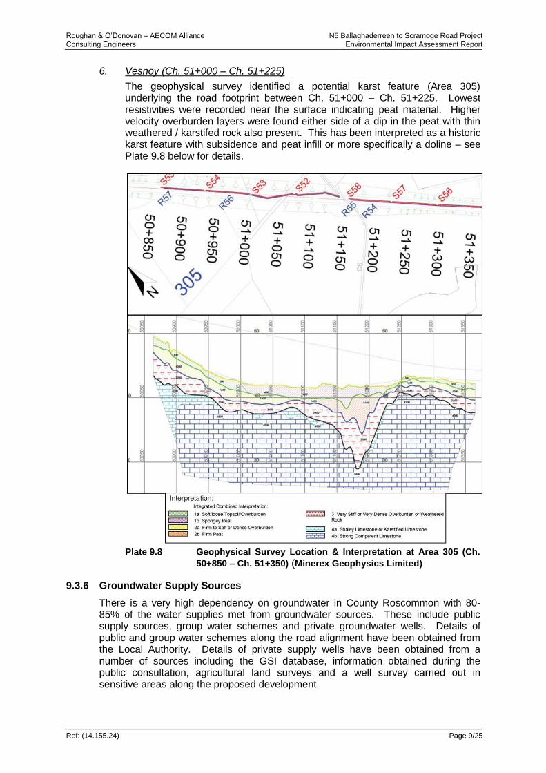
6. Vesnoy (Ch. 51+000 – Ch. 51+225)
The geophysical survey identified a potential karst feature (Area 305) underlying the road footprint between Ch. 51+000 – Ch. 51+225. Lowest resistivities were recorded near the surface indicating peat material. Higher velocity overburden layers were found either side of a dip in the peat with thin weathered / karstifed rock also present. This has been interpreted as a historic karst feature with subsidence and peat infill or more specifically a doline – see Plate 9.8 below for details.
Plate 9.8 Geophysical Survey Location & Interpretation at Area 305 (Ch.
50+850 – Ch. 51+350) (Minerex Geophysics Limited)
9.3.6 Groundwater Supply Sources
There is a very high dependency on groundwater in County Roscommon with 80-85% of the water supplies met from groundwater sources. These include public supply sources, group water schemes and private groundwater wells. Details of public and group water schemes along the road alignment have been obtained from the Local Authority. Details of private supply wells have been obtained from a number of sources including the GSI database, information obtained during the public consultation, agricultural land surveys and a well survey carried out in sensitive areas along the proposed development.
Roughan & O’Donovan – AECOM Alliance N5 Ballaghaderreen to Scramoge Road Project Consulting Engineers Environmental Impact Assessment Report
Ref: (14.155.24) Page 9/26
9.3.6.1 Source Protection Schemes
The GSI carries out source protection mapping whereby source protection areas are delineated around significant groundwater supply sources. The areas are subdivided into inner (SI) and outer (SO) protection areas, based on the 100 day Time of Travel (TOT) and the catchment area respectively. The associated groundwater vulnerability is superimposed on these sub-divisions, to give source protection zones as listed below in Table 9.11 (DoELG, EPA & GSI, 1999). Table 9.11: Groundwater Vulnerability Rating Relevant To Source
Protection Zones
Vulnerability Rating Source Protection Zone
Inner (SI) Outer (SO)
Extreme (E) SI/E SO/E
High (H) SI/H SO/H
Moderate (M) SI/M SO/M
Low (L) SI/L SO/L
Source protection areas are delineated using several hydrogeological methods, varying in complexity, cost and the level of data and hydrogeological analysis required. Four methods, in order of increasing technical sophistication, that are used by the GSI are: calculated fixed radius; analytical methods; hydrogeological mapping; and numerical modelling. As each method has limitations the boundaries must be seen as a guide for decision-making which can be reappraised in the light of new knowledge or changed circumstances. Inner Source Protection (SI) zones are designed to protect against the effects of human activities that might have an immediate effect on the source and, in particular, against microbial pollution. The area is defined by a 100-day TOT from any point below the water table to the source. In karst areas, it will not usually be feasible to delineate 100-day TOT boundaries, as there are large variations in permeability, high flow velocities and a low level of predictability. In these areas, the total catchment area of the source will frequently be classed as SI. If it is necessary to use the arbitrary fixed radius method, a distance of 300m is normally used. A semi-circular area is used for springs. The distance may be increased for sources in karst aquifers and reduced in granular aquifers and around low yielding sources (DoELG, EPA & GSI, 1999). In karst areas, for spring sources, dye tracing surveys are carried out to identify the extent of the source protection area. The Outer Source Protection (SO) zone area covers the remainder of the zone of contribution (ZOC) (or complete catchment area) of the groundwater source. It is defined as the area needed to support an abstraction from long-term groundwater recharge i.e. the proportion of effective rainfall that infiltrates to the water table. The abstraction rate used in delineating the zone will depend on the views and recommendations of the source owner. A factor of safety can be taken into account whereby the maximum daily abstraction rate is increased (typically by 50%) to allow for possible future increases in abstraction and for expansion of the ZOC in dry periods. In order to take account of the heterogeneity of many Irish aquifers and possible errors in estimating the groundwater flow direction, a variation in the flow direction (typically ±10-20°) is frequently included as a safety margin in delineating the ZOC. If the arbitrary fixed radius method is used, a distance of 1000m is
Roughan & O’Donovan – AECOM Alliance N5 Ballaghaderreen to Scramoge Road Project Consulting Engineers Environmental Impact Assessment Report
Ref: (14.155.24) Page 9/27
recommended with, in some instances, variations in karst aquifers and around springs and low-yielding wells (DoELG, EPA & GSI, 1999). The boundaries of the source protection areas are based on the horizontal flow of water to the source and, in the case particularly of the Inner Protection Area, on the time of travel in the aquifer. Consequently, the vertical movement of a water particle or contaminant from the land surface to the water table is not taken into account. This vertical movement is a critical factor in contaminant attenuation, contaminant flow velocities and in dictating the likelihood of contamination, and can be taken into account by mapping the groundwater vulnerability to contamination (DoELG, EPA & GSI, 1999). Source protection mapping has not been carried out by the GSI for the three groundwater supplies (Peak-Mantua, Curracreigh and Polecat GWS‘s) that are located in the vicinity of the road alignment. However, Zone of Contribution (ZOC) mapping has been carried out by the GSI and ZOC reports are available and have been consulted. It must be noted that one of these reports is at draft stage (Peak-Mantua) and the ZOC is currently in the process of being revised.
9.3.6.2 Regional Water Supply Schemes
There is one regional supply scheme within the vicinity of the proposed alignment. The North Roscommon Regional Water Supply Scheme serves approximately 6,500 people in the vicinity of Ballaghaderreen and is sourced by surface water from Lower Lough Gara approximately 2.7km north of the road alignment. An abstraction rate of 7,000m3/day from the lough was reported by the EPA in 2014. The lough is fed primarily by the Breedoge and Lung Rivers however it is likely that groundwater springs are also contributing to water levels in the lough.
9.3.6.3 Group Water Supply Schemes
There are three Group Water Supply (GWS) schemes within the vicinity of the proposed road development as detailed below:
(i) Peak Mantua GWS; this supply source is fed through a spring supply. There is a groundwater source protection plan being developed by the GSI for this scheme – a draft version of this report was available for review.
(ii) Curracreigh GWS; this supply source is fed through a spring. There is a groundwater source protection plan developed by the GSI for the scheme.
(iii) Polecat GWS; this supply source is fed through a spring. There is a groundwater source protection plan developed by the GSI for the scheme.
Each of these groundwater supply schemes are described in detail below: Peak Mantua GWS
The Peak Mantua GWS consists of a spring water supply with an abstraction rate of 80m3/day. The supply source is named Tober Knockageely spring and is marked as a Holy Well on the historic ordnance survey mapping of the area. The spring is located to the east of Bellanagare in the townland of Peak – refer Plate 9.9 below. This scheme supplies approximately 40 domestic connections and serves up to 90 people. The spring supplies water to a holding tank by gravity with an overflow into an adjacent drainage ditch which flows into a tributary of the Owennaforeesha River. The water supply is disinfected prior to entering domestic supply with filtration, ultra violet irradiation and chlorination all taking place.

Roughan & O’Donovan – AECOM Alliance N5 Ballaghaderreen to Scramoge Road Project Consulting Engineers Environmental Impact Assessment Report
Ref: (14.155.24) Page 9/28
The topography of the surrounding area is generally flat with a slight gradient to the west/north west. There is higher ground c. 3km to the south (maximum elevation of 161mOD) and lower ground to the north. The surface water catchment generally drains in a north-westerly direction. Land use in the area is predominantly low intensity agricultural usage for grazing purposes. There is a plot of forestry located to the west of the supply and a larger area under forestry to the east. The supply is located in a rural setting with few houses in the vicinity.
Plate 9.9 Location of the Peak Mantua GWS Spring (Not to Scale)
The area is underlain by limestone which is classified as a Regionally Important Karst Aquifer dominated by conduit flow (Rkc). The area immediately surrounding the spring is mapped as having peaty soils present with low permeability glacial till present across most of the surrounding area. Subsoil cover is highly variable and bedrock is exposed in many areas particularly to the south and west. Groundwater vulnerability in the vicinity of the spring is classified as being low with high and extreme vulnerability area located to the south and west. The location of the spring and the reported regional drainage pattern suggests that groundwater flow arises from the Rathcroghan Uplands to the south and flows northwards generally reflecting local topography. Recharge occurs in a diffuse manner across the area from rock outcrops and through the overlying subsoils. Recharge may also occur directly through specific karst points of entry such as swallow holes and dolines but no such point sources have been identified from the recent tracer surveys. Groundwater flows occur in the limestone bedrock from the upland area to the south through interconnected joints, fissures and fractures many of which may be solutionally enlarged. Groundwater then discharges to springs and streams to the north including Tober Knockageely spring. The GSI draft Zone of Contribution report document for this supply reports that the groundwater table is assumed to be a subdued reflection of topography with the locations of water courses and springs around the perimeter of higher ground reflecting where the water table intersects with

Roughan & O’Donovan – AECOM Alliance N5 Ballaghaderreen to Scramoge Road Project Consulting Engineers Environmental Impact Assessment Report
Ref: (14.155.24) Page 9/29
the low-lying ground at the base of the hill. The GSI have therefore developed a draft ZOC map for the Peak Mantua GWS as shown in Plate 9.10 below.
Plate 9.10 Zone of Contribution (ZOC) for the Peak Mantua GWS Scheme
(Source: GSI, 2016) (Not to Scale)
The road alignment passes to the north of Tober Knockageely spring and is therefore outside the current draft zone of contribution which has been developed by the GSI. The GSI is currently in the process of revising the ZOC for this scheme and are undertaking a number of trace tests in the area to better understand groundwater flow. A number of swallow holes and karst features have however been identified in the vicinity of the Peak/Mantua area – see Plate 9.10 above for details. Given that the ZOC is still at draft development stage, there was a possibility that karst features to the east and particularly a swallow hole located adjacent to the R369 at Corry West could be connected to the karst system with the ZOC in that scenario extending further to the east. In order to confirm if the Polloweween swallow hole feature at Kilvoy Corry West is connected to the Peak-Mantua hydrogeological system, a tracing study was carried out in June 2015 as part of this assessment. Further tracing studies were also carried out as part of this assessment and by the GSI in May/June 2016. The 2015 tracer study involved a discrete slug of Rhodamine WT dye being injected into the swallow hole with 13 No. potential downstream locations being monitored for the appearance of the dye over a number of weeks. No evidence of the dye inserted into the swallow hole at Mantua was found at the Peak-Mantua GWS supply springs or in any of the surrounding monitored locations. Out of the thirteen monitoring locations a dye trace was only observed at a single location at Carrownahorheeny/Shankill. This tracer test was carried out in conjunction with the GSI who were also carrying out tracing studies in the wider area to identify sources for both the Peak-Mantua Group scheme spring supply and the Curracreigh GWS source (see description below). The GSI tracing which released various dyes at five Swallow hole features in the wider area to the south of the road alignment and confirmed positive links for the Curracreigh GWS source (described below). Further tracer tests were carried out by GSI in the area north of the Peak-Mantua supply in June/July 2016 to more accurately delineate the Zone of Contribution (ZOC) boundary for both supplies and no connections were confirmed southwards to these
Roughan & O’Donovan – AECOM Alliance N5 Ballaghaderreen to Scramoge Road Project Consulting Engineers Environmental Impact Assessment Report
Ref: (14.155.24) Page 9/30
spring supplies. Two positive connections between the Rathcroghan upland plateau to the south were confirmed to the Peak-Mantua supply spring. In addition three positive connections were confirmed between this upland area (south of the proposed alignment) and the Curracreigh GWS supply spring. These trace lines are shown in Plate 9.14 below. Each of these traced connections confirm the assumptions made by the GSI in delineating the draft ZOC boundary of the Peak-Mantua and Curracreigh supplies with the upland area to the south providing the recharge zone for both supplies. In this regard the proposed road development is located outside the ZOC of both the Peak-Mantua GWS and the Curracreigh GWS. A further tracer study, undertaken by Roughan & O’Donovan in May 2016, confirmed that the karst swallow hole features located adjacent to the proposed alignment at Corry West are connected to springs located outside Elphin and not the Peak-Mantua or Curracreigh supplies. Further details of this trace are given in the Polecat GWS description below – see Plate 9.14. Curracreigh GWS
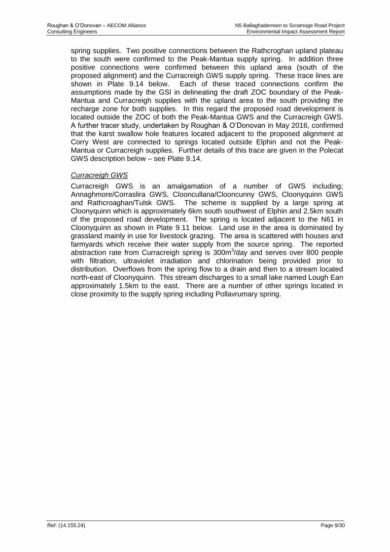
Curracreigh GWS is an amalgamation of a number of GWS including; Annaghmore/Corraslira GWS, Clooncullana/Clooncunny GWS, Cloonyquinn GWS and Rathcroaghan/Tulsk GWS. The scheme is supplied by a large spring at Cloonyquinn which is approximately 6km south southwest of Elphin and 2.5km south of the proposed road development. The spring is located adjacent to the N61 in Cloonyquinn as shown in Plate 9.11 below. Land use in the area is dominated by grassland mainly in use for livestock grazing. The area is scattered with houses and farmyards which receive their water supply from the source spring. The reported abstraction rate from Curracreigh spring is 300m3/day and serves over 800 people with filtration, ultraviolet irradiation and chlorination being provided prior to distribution. Overflows from the spring flow to a drain and then to a stream located north-east of Cloonyquinn. This stream discharges to a small lake named Lough Ean approximately 1.5km to the east. There are a number of other springs located in close proximity to the supply spring including Pollavrumary spring.
Roughan & O’Donovan – AECOM Alliance N5 Ballaghaderreen to Scramoge Road Project Consulting Engineers Environmental Impact Assessment Report
Ref: (14.155.24) Page 9/31
Plate 9.11 Location of the Curracreigh GWS Spring (Not to Scale)
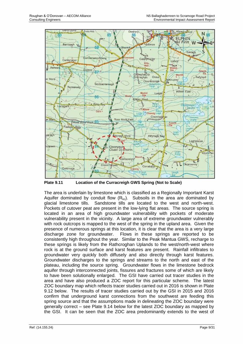
The area is underlain by limestone which is classified as a Regionally Important Karst Aquifer dominated by conduit flow (Rkc). Subsoils in the area are dominated by glacial limestone tills. Sandstone tills are located to the west and north-west. Pockets of cutover peat are present in the low-lying flat areas. The source spring is located in an area of high groundwater vulnerability with pockets of moderate vulnerability present in the vicinity. A large area of extreme groundwater vulnerably with rock outcrops is mapped to the west of the spring in the upland area. Given the presence of numerous springs at this location, it is clear that the area is a very large discharge zone for groundwater. Flows in these springs are reported to be consistently high throughout the year. Similar to the Peak Mantua GWS, recharge to these springs is likely from the Rathcroghan Uplands to the west/north-west where rock is at the ground surface and karst features are present. Rainfall infiltrates to groundwater very quickly both diffusely and also directly through karst features. Groundwater discharges to the springs and streams to the north and east of the plateau, including the source spring. Groundwater flows in the limestone bedrock aquifer through interconnected joints, fissures and fractures some of which are likely to have been solutionally enlarged. The GSI have carried out tracer studies in the area and have also produced a ZOC report for this particular scheme. The latest ZOC boundary map which reflects tracer studies carried out in 2016 is shown in Plate 9.12 below. The results of tracer studies carried out by the GSI in 2015 and 2016 confirm that underground karst connections from the southwest are feeding this spring source and that the assumptions made in delineating the ZOC boundary were generally correct – see Plate 9.14 below for the latest ZOC boundary as mapped by the GSI. It can be seen that the ZOC area predominantly extends to the west of

Roughan & O’Donovan – AECOM Alliance N5 Ballaghaderreen to Scramoge Road Project Consulting Engineers Environmental Impact Assessment Report
Ref: (14.155.24) Page 9/32
Cloonyquinn towards the (Rathcroghan) upland area and that the proposed road development is located well outside the ZOC boundary.
Plate 9.12 Zone of Contribution (ZOC) for the Curracreigh GWS Scheme (Source:
GSI, 2016) (Not to Scale)
Polecat Spring GWS
The Polecat Springs GWS consists of a spring fed water supply with an estimated abstraction rate of 550m3/day. The supply source consists of a surface abstraction from a large groundwater spring supply. There are also two other groundwater springs located in the immediate vicinity (but not abstracted from) and all three are connected to the same underlying aquifer. The average yield of the main Polecat spring has been estimated by the GSI at 4,500m3/day. The springs are located to the north-east of Elphin in the townland of Lissavilla – refer to Plate 9.13 below. This scheme supplies approximately 1000 domestic and agricultural connections and serves up to 400 people. The main spring is located in a low-lying valley adjacent to the L-1031 approximately 3km north-east of Elphin. A broad plateau orientated north-south occurs west of the spring, extending from Elphin to Croghan (8km to the northwest). The surrounding area to the north of the main spring is scattered with drumlins which are oriented southwest-northeast. Land use in the surrounding area is mainly agricultural and is used for grazing.
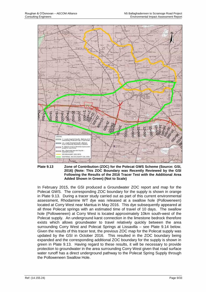
Roughan & O’Donovan – AECOM Alliance N5 Ballaghaderreen to Scramoge Road Project Consulting Engineers Environmental Impact Assessment Report
Ref: (14.155.24) Page 9/33
Plate 9.13 Zone of Contribution (ZOC) for the Polecat GWS Scheme (Source: GSI,
2016) (Note: This ZOC Boundary was Recently Reviewed by the GSI Following the Results of the 2016 Tracer Test with the Additional Area Added Shown in Green) (Not to Scale)
In February 2015, the GSI produced a Groundwater ZOC report and map for the Polecat GWS. The corresponding ZOC boundary for the supply is shown in orange in Plate 9.13. During a tracer study carried out as part of this current environmental assessment, Rhodamine WT dye was released at a swallow hole (Polloweneen) located at Corry West near Mantua in May 2016. This dye subsequently appeared at all three Polecat springs with an estimated time of travel of 10 days. The swallow hole (Polloweneen) at Corry West is located approximately 10km south-west of the Polecat supply. An underground karst connection in the limestone bedrock therefore exists which allows groundwater to travel relatively quickly between the area surrounding Corry West and Polecat Springs at Lissavilla – see Plate 9.14 below. Given the results of this tracer test, the previous ZOC map for the Polecat supply was updated by the GSI in October 2016. This resulted in the ZOC boundary being expanded and the corresponding additional ZOC boundary for the supply is shown in green in Plate 9.13. Having regard to these results, it will be necessary to provide protection to groundwater in the area surrounding Corry West given that road surface water runoff has a direct underground pathway to the Polecat Spring Supply through the Polloweneen Swallow Hole.

Roughan & O’Donovan – AECOM Alliance N5 Ballaghaderreen to Scramoge Road Project Consulting Engineers Environmental Impact Assessment Report
Ref: (14.155.24) Page 9/34
Plate 9.14 Latest Karst Traced Underground Connection Map Published by the GSI (GSI, August 2016). The 2 No. Roughan & O’Donovan Trace Lines are Shown from the Polloweneen Swallow Hole (Not to Scale).
Northeast Roscommon Regional Water Supply Scheme
The North East Roscommon Regional Water Supply extends from Roosky in the east to Tulsk in the west and from Drumsna in the north to Ballyleague in the south. The water supply scheme serves over 5,000 people including residents of Strokestown, Elphin, Tulsk and Scramoge. The supply for this source is taken from Lisheen Lake located approximately 6km north of Strokestown. Roscommon County Council also maintain a number of groundwater supply boreholes located in the vicinity of Strokestown. Drinking water supply for residents in areas surrounding Strokestown is augmented from these boreholes. Groundwater protection zones have not been drawn up for these supplies by either the GSI or the EPA. The closest of these boreholes is located at Kiltrustan located to the north of Strokestown. This supply is from deep abstraction boreholes which are drilled to a depth of c.62.5m with a reported maximum abstraction rate of 59m3/day. Commercial and Industrial Water Supplies
There are no large commercial or industrial premises along the proposed alignment route. A large limestone quarry (Laragan Quarry) is located on the northeastern slopes of Greywood Hill. The quarry is supplied by the public supply and has its own abstraction well bored deep into the limestone Bedrock. Domestic and Agricultural Water Supplies
The majority of residential houses along the proposed road alignment are connected to either the North Roscommon Regional water supply scheme or the Peak Mantua GWS. A total of 20 groundwater supply boreholes or spring wells for domestic and agricultural use were identified during the assessment of the study area. Many of these locations are also connected to mains supplied water. A number of springs and seepages were identified that are used primarily for livestock.
Polloweneen
Swallow Hole
Polecat Main Spring
Curracreigh
Spring GWS
Peak-Mantua Spring GWS
Roughan & O’Donovan – AECOM Alliance N5 Ballaghaderreen to Scramoge Road Project Consulting Engineers Environmental Impact Assessment Report
Ref: (14.155.24) Page 9/35
9.3.7 Natural Heritage
The NPWS and GSI websites were queried regarding the presence of any listed wetland habitats or geological heritage sites traversed by the proposed road alignment, or within the immediate area. A comprehensive review of Biodiversity and Soils & Geology are given separately in Chapters 7 & 8 and therefore a summarised overview of designated sites is given below.
9.3.7.1 Designated Sites
Special Areas of Conservation (SPA) and Special Protection Areas (SPA) are afforded legal protection under European Legislation for the conservation of natural habitats and of wild flora and fauna. SAC’s and SPA’s form part of the NATURA 2000 network of European wide protected sites. A number of priority habitats are also listed which afford special conservation status and attract stricter protection. No SAC or SPA is traversed by the proposed road, however there are six designated sites which were screened-in during Appropriate Assessment; Bellenagare Bog (cSAC and SPA), Annaghmore Lough (cSAC), Cloonshanville Bog (cSAC & SPA), Lough Gara (SPA) and Lough Forbes Complex (SPA). Bellanagare Bog cSAC and SPA
Bellanagare Bog is listed as a SPA (Ref. 004105), a candidate Special Area of Conservation (000592) and is also listed as a proposed National Heritage Area (pNHA) (Ref. 000592). The bog is located some 1.5km south of Frenchpark in the townland of Leggatinty. The road alignment passes approximately 200m to the north of Bog. The bog shows the characteristics of a blanket bog habitat and is classified as an intermediate raised bog. The site is selected as a SAC for the following habitats and/or species listed on Annex I&II of the E.U. Habitats Directive: Active Raised Bog [7110], Degraded Raised Bog [7120], Rhynchosporion Vegetation [7150], Marsh Fritillary (Euphydryas aurinia) [1065]. Annaghmore Lough cSAC
Annaghmore Lough is designated as a candidate Special Area of Conservation (Ref. 001626) and is located approximately 3km south of Elphin. The Lough lies at the centre of a network of small lakes in a rolling, drift-covered landscape. The site was selected as a cSAC for the following habitats and/or species listed on Annex I&II of the E.U. Habitats Directive: Alkaline fens [7230] and Vetigo geyeri (Geyer's Whorl Snail) [1013]). In addition the site is important for wintering birds and is listed as a wildfowl sanctuary (WFS-44). This site is relatively intact with minor damage; cattle grazing, burning on the fen and drainage pose the main potential threats to the site. This is a site of considerable conservation importance given the habitats and rare species present. The proposed road development passes approximately 0.9km to the north of this SAC. Cloonshanville Bog cSAC
Cloonshanville Bog is designated as a candidate Special Area of Conservation (Ref. 000614) and is located approximately 1km north of Frenchpark in the townland of Cloonshanville. The site was selected as a cSAC for the following habitats and/or species listed on Annex I&II of the E.U. Habitats Directive: Active raised bogs [7110], Degraded raised bogs still capable of natural regeneration [7120], Depressions on peat substrates of the Rhynchosporion [7150] and Bog woodland [91D0]. A large flush area occurs in the centre of the bog. This body of flush bogland is reported as supporting an extensive area of bog woodland. It is likely that these wetland

Roughan & O’Donovan – AECOM Alliance N5 Ballaghaderreen to Scramoge Road Project Consulting Engineers Environmental Impact Assessment Report
Ref: (14.155.24) Page 9/36
conditions are maintained by groundwater springs or seepages. The road alignment passes within 1.7km to the south of this designated site Lough Gara SPA
Lough Gara is a shallow medium-sized lake, situated some 6km north-east of Ballaghaderreen. There are two main sections to the lake, a larger northern basin and a smaller southern basin which are joined by a narrow channel. The main inflowing river to the lake system is the River Lung while the main outflow from the lake is the River Boyle. The lake is classified as a mesotrophic system, with reduced planktonic algal growth. Callow Bog cSAC is situated on the southern shore of the lake. The site was selected as a Special Protection Area due to the presence of the following species: Whooper Swan (Cygnus cygnus) [A038] and Greenland White-fronted Goose (Anser albifrons flavirostris) [A395]. Lough Forbes Complex cSAC (001818)
This cSAC consists of a natural lake system, active raised bogs degraded raised bogs, depressions on peat substrates and alluvial forests. The site is a Special Area of Conservation (SAC) selected for the following habitats and/or species listed on Annex I& II of the E.U. Habitats Directive Natural Eutrophic Lakes [3150], Raised Bog (Active) [7110], Degraded Raised Bog [7120], Rhynchosporion Vegetation [7150], Alluvial Forests [91E0]. This site is located downstream of the road project and is fed by the River Shannon.
9.3.7.2 National Heritage Areas (NHA’s)
There are no National Heritage Areas (NHA’s) in the immediate vicinity of the road alignment, however Bellangare Bog is designated as a pNHA (Ref. 000592) and is described above due to it being afforded additional protection as a SPA and cSAC. There are also 3 NHA’s just north of Frenchpark; Bella Bridge Bog, Cornaveagh Bog and Tullaghan Bog.
9.3.7.3 Geological Heritage Sites
There is a statutory requirement placed on Local Authorities to have due regard for conservation of geological heritage features under the Planning and Development Act 2000, as amended, the Planning and Development Regulations 2001, the Heritage Act 1995 and the Wildlife (Amendment) Act 2000. The Irish Geological Heritage Programme is a partnership between the GSI and the NPWS. It aims to identify, document, and protect the wealth of geological heritage in the Republic of Ireland and conserve it against ever increasing threats, and also to promote its value with the landowners and the public. The GSI provides scientific appraisal and interpretative advice on geological and geomorphological sites, and is responsible for the identification of important sites that are capable of being conserved as NHAs. Of the majority of geological sites not eventually selected for NHA designation, some have been promoted as County Geological Sites (CGS), which have no statutory protection, but may be included within County Development Plans. Many counties have now adopted CGS’s into their development plans, and are promoting their interest through Heritage Plans (GSI website). CGS’s have been incorporated into the Roscommon County Development Plan 2014-2020, listed as ‘Sites of Geological Interest’. The following are located along the proposed road development:
Roughan & O’Donovan – AECOM Alliance N5 Ballaghaderreen to Scramoge Road Project Consulting Engineers Environmental Impact Assessment Report
Ref: (14.155.24) Page 9/37
Mid Roscommon Ribbed Moraines (RO022)
The Mid Roscommon Ribbed Moraines (Ref. RO022) are listed in the Roscommon County Development plan as a ‘County Geological Site’. The area consists of a ribbed moraine field with superimposed drumlins. The road development passes through this site along the eastern section of the alignment from Ch. 30+000 to the eastern tie in with the existing road. The features are too large to conserve however the landscape itself is unique and is recommended for promotion by the GSI. Few restrictions are imposed for development within this area however consultation with the GSI is advised. The GSI was consulted regarding the road development and has requested access and information during construction works in order to gain information on the geology of the area to supplement data currently held on record. Pollnagran Cave (RO026)
Pollnagran is a 750m long, active stream cave located in the townland of Leggatinty near Frenchpark. It is the only known active stream cave in County Roscommon. The cave has an entrance on private lands in a shallow valley where a surface stream disappears underground. The cave therefore forms part of a wider active karst limestone bedrock system in the area with the stream emerging as a spring to the north. Noted as a rare active stream cave, the GSI have designated it as a County Geological Site given its unusual and rare nature in County Roscommon. Laragan Quarry (RO016)
Laragan Quarry is a large working quarry located north of Strokestown. The road alignment passes to the south of the quarry and within 150m distance. The quarry is excavated into Carboniferous limestone which is reported as potentially belonging to the Ballymore Limestone Formation. The quarry provides a view of near perfect horizontal limestone beds and provides a window into the bedrock which is normally rarely exposed in County Roscommon. The GSI reports the quarry as a good representative site displaying Carboniferous limestone bedrock in County Roscommon. It is anticipated that the representative rock faces exposed in the quarry will be preserved for geological purposes after the final closure stage of the quarry.
9.3.7.4 Sites of Key Ecological Interest (KER’s)
The ecological assessments for the project were reviewed to locate any sites along the proposed road alignment that could be potentially impacted relative to hydrogeological aspects. Key ecological receptors were identified by the Ecological Specialist as described in Chapter 7 Biodiversity of this EIAR. Ecological receptors were reviewed and those found to be sensitive to changes to hydrological and hydrogeological regimes are summarised in Table 9.12 below. Table 9.12: Ecological Receptors Of Interest (Refer To Chapter 7 -
Biodiversity For Further Details)
No. Location/Name Chainage Main Habitat(s) Conservation Rating
KERs 1a(N) & 1b(C)
Turlaghnamaddy 4+000 – 4+500
Wet Grasslands with encroaching scrub (Molina Meadows)
Potential Marsh Fritillary Habitat
National
County

Roughan & O’Donovan – AECOM Alliance N5 Ballaghaderreen to Scramoge Road Project Consulting Engineers Environmental Impact Assessment Report
Ref: (14.155.24) Page 9/38
No. Location/Name Chainage Main Habitat(s) Conservation Rating
KERs 2a(LH) & 2b(N)
Frenchpark 5+000 – 5+500
Cutover bog
Raised Bog
Local Higher
National
KER 4(C) Leggatinty 10+750 – 10+850
Wet Grasslands with encroaching scrub (Molina Meadows)
County
KER 5(N) Leggatinty 11+750 – 11+850
Wet Grasslands with encroaching scrub (Molina Meadows)
National
KERs 6a(N), 6bN), 6b(C), 6b(LH), 6c(N), 6c(LH), 6c(LL)
Leggatinty/ Derreen
10+900 – 12+350
Raised & Cutover bog
Cutover bog recolonised with wet grassland and scrub
National & County
Local
KERs 15a(LH), 15b(LL), 15c(N), 15d(C), 15e(C)
Tullyloyd 33+350 – 35+750
Alkaline Fen
Wet Grassland
Annex I Alkaline Fen
Transition mire and rich fen habitat
Local Higher
Local Lower
National
County
KER 16(N)
Cregga 36+650 – 37+950
Turlough and associated groundwater dependent habitats (Annex I Habitat)
National
KER17 (LH)
Cloonradoon 50+850 – 51+800
Raised & Cutover bog Local Higher
9.3.8 Hydrochemical and Groundwater Table Data
In order to quantify the existing environment and establish existing baseline groundwater quality, an assessment of existing groundwater quality has been made utilising all available information.
9.3.8.1 Preliminary Water Quality Testing
A water sampling programme has been undertaken as part of the EIAR preparation in order to establish baseline quality in the underling aquifers. A number of piezometers and standpipes were installed in boreholes which were drilled as part of preliminary ground investigations – refer to Chapter 8 for details. Six of these locations were sampled on a bi-monthly basis for a suite of water quality parameters. In addition water quality sampling has also taken place at Cregga Turlough (GW5) which is an area of groundwater/surface-water interaction. Results of the water quality testing are given in Table 9.13 below. The locations of these water quality sampling points are given in Figures 10.2 – 10.6 in EIAR Volume 3.
Table 9.13: Summary* of Hydrochemistry and Water Quality at Groundwater
Sampling Locations
Location pH Total N
mg/l
No2-N
mg/l
No3-N
mg/l
Total P
µg/l
MRP
µg/l
Total Coliforms
(cfu/100ml)
Faecal Coliforms
(cfu/100ml)
Mg
(mg/l)
GW1 6.6 11.9 <0.005 <0.1 1.61 0.016 22.5 23 36.5

Roughan & O’Donovan – AECOM Alliance N5 Ballaghaderreen to Scramoge Road Project Consulting Engineers Environmental Impact Assessment Report
Ref: (14.155.24) Page 9/39
Location pH Total N
mg/l
No2-N
mg/l
No3-N
mg/l
Total P
µg/l
MRP
µg/l
Total Coliforms
(cfu/100ml)
Faecal Coliforms
(cfu/100ml)
Mg
(mg/l)
GW2 6.85
1.13 <0.005 0.923 0.06 0.032 165 80 <5
GW3 7.1 <0.5 <0.005 0.288 0.07 0.014 10000 1000 <5
GW4 7 <0.5 <0.005 0.186 0.68 0.013 1250 <100 6
GW5 (Cregga
Turlough)
7.5 0.90 <0.005 0.515 <0.05 0.028 160 36 36
GW6 7.4 1.11 <0.005 <0.1 0.39 0.093 2000 200 12
*Mean values quoted
9.3.8.2 Regional Water Supply Schemes
No water chemistry data were available for raw water quality at the abstraction point for the North Roscommon Water Supply. A high level of treatment occurs prior to distribution with water quality monitored on a daily basis.
9.3.8.3 Groundwater Supply Schemes (GWS’s)
Peak Mantua GWS
The water supply at Peak Mantua is reported as being ‘flashy’ and highly responsive to rainfall. This is due to the karst nature of the underlying bedrock with rapid entry of rainfall to groundwater through karst features such as dolines and swallow holes and the subsequent fast time of travel through fractures and fissures in the bedrock possible. Quality data of both treated and untreated water have been collected over an extended period and a summary of hydrochemistry and water quality data is given in Table 9.14 below. Generally values are within both the Drinking Water Limit (DWL) and Threshold Values (TV). The water is ‘hard’ with a reported calcium carbonate concentration of 354 mg/l. The ‘hard’ nature of the water is caused by the dissolution of calcium carbonate when the water passes through the limestone bedrock. Microbial contamination was found to be present in both the untreated and the treated water historically. In addition Clostridium perfringens and Cryptosporidium have been present historically (prior to UV treatment being incorporated) in the treated water suggesting agricultural pollution sources. Individual elevated levels of ammonium, aluminium and iron may be associated with the peat which is present in the vicinity of the spring. The presence of microbial contamination and the high variation in other water quality parameters highlights the vulnerability of this water supply to contamination. The karst nature of the surrounding bedrock aquifer which allows rapid recharge through karst features is the most likely pathway for contaminants entering this water supply. Table 9.14: Summary of Hydrochemistry and Water Quality from the Treated
Water at the Peak Mantua GWS (Source: GSI)
Parameter Average Value Drinking water limit DWL) / Threshold Value (TV)
Conductivity (μS/cm) 585 1500
pH 7.5 -
Calcium Carbonate (CaCO3) (mg/l) 354 -
Nitrate (NO3-N) (mg/l) 4.5 50; 37.5
Ammonium (NH4-N) (mg/l) 0.042 0.233, 0.175
Chloride (Cl) (mg/l) 15.8 250; 24

Roughan & O’Donovan – AECOM Alliance N5 Ballaghaderreen to Scramoge Road Project Consulting Engineers Environmental Impact Assessment Report
Ref: (14.155.24) Page 9/40
Parameter Average Value Drinking water limit DWL) / Threshold Value (TV)
Total Coliforms (MPN/100ml) 35 exceedances 0
Faecal Coliforms (MPN/100ml) 32 exceedances 17 exceedances
(>100 counts) 0
Manganese (μg/l) 14 50 (DWL – indicator parameter)
Iron (μg/l) 51 200
Curracreigh GWS
Water quality at the Curragreigh GWS is highly variable. A rapid response to rainfall is reported which is likely related to karst features which allow direct and rapid entry of rainfall to groundwater and therefore heavy rainfall events strongly impact water quality. Water quality data were collected over an extended period and a summary of hydrochemistry and water quality data is given in Table 9.15 below. Generally values are within both the DWL and TV. The water is ‘hard’ with an average calcium carbonate concentration of 338 mg/l and this is due to the underlying limestone bedrock through which the water flows. A historic presence of total and faecal coliforms is reported in untreated (raw) water results, however no coliforms were found in the most recent raw water sampling undertaken in 2014. Between 2002 and 2012, total/faecal coliforms were present in treated water samples in 3 of 43 samples. Clostridium perfringens were reported in the treated water on five occasions most recently in 2010. Elevated phosphate concentrations were also reported historically. The presence of microbial contamination and elevated levels of other water quality parameters highlights the vulnerability of this supply. Direct recharge through karst features is the most likely pathway for contaminants entering this water supply. Table 9.15: Summary of Hydrochemistry and Water Quality from the Treated
Water at the Curracreigh GWS (Source: GSI)
Parameter Average Value Drinking Water Limit DWL) / Threshold Value (TV)
Conductivity (μS/cm) 572 1500
pH 7 -
Calcium Carbonate (CaCO3) (mg/l) 338 -
Nitrate (NO3-N) (mg/l) 7.5 50; 37.5
Ammonium (NH4-N) (mg/l) 0.026 0.233, 0.175
Chloride (Cl) (mg/l) 13.1 250; 24
Total Coliforms (MPN/100ml) 17 exceedances (<100 counts)
12 exceedances (>100 counts)
0
Faecal Coliforms (MPN/100ml) 19 exceedances (<100 counts)
10 exceedances (>100 counts)
0
Manganese (μg/l) 14 50 (DWL – indicator parameter)
Iron (μg/l) 72 200
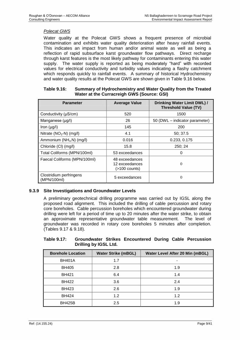
Roughan & O’Donovan – AECOM Alliance N5 Ballaghaderreen to Scramoge Road Project Consulting Engineers Environmental Impact Assessment Report
Ref: (14.155.24) Page 9/41
Polecat GWS
Water quality at the Polecat GWS shows a frequent presence of microbial contamination and exhibits water quality deterioration after heavy rainfall events. This indicates an impact from human and/or animal waste as well as being a reflection of rapid subsurface karst groundwater flow pathways. Direct recharge through karst features is the most likely pathway for contaminants entering this water supply. The water supply is reported as being moderately “hard” with recorded values for electrical conductivity and turbidity values indicating a flashy catchment which responds quickly to rainfall events. A summary of historical Hydrochemistry and water quality results at the Polecat GWS are shown given in Table 9.16 below. Table 9.16: Summary of Hydrochemistry and Water Quality from the Treated
Water at the Curracreigh GWS (Source: GSI)
Parameter Average Value Drinking Water Limit DWL) / Threshold Value (TV)
Conductivity (μS/cm) 520 1500
Manganese (μg/l) 26 50 (DWL – indicator parameter)
Iron (μg/l) 145 200
Nitrate (NO3-N) (mg/l) 4.1 50; 37.5
Ammonium (NH4-N) (mg/l) 0.016 0.233, 0.175
Chloride (Cl) (mg/l) 15.8 250; 24
Total Coliforms (MPN/100ml) 53 exceedances 0
Faecal Coliforms (MPN/100ml) 48 exceedances 12 exceedances
(>100 counts)
0
Clostridium perfringens (MPN/100ml)
5 exceedances 0
9.3.9 Site Investigations and Groundwater Levels
A preliminary geotechnical drilling programme was carried out by IGSL along the proposed road alignment. This included the drilling of cable percussion and rotary core boreholes. Cable percussion boreholes which encountered groundwater during drilling were left for a period of time up to 20 minutes after the water strike, to obtain an approximate representative groundwater table measurement. The level of groundwater was recorded in rotary core boreholes 5 minutes after completion. (Tables 9.17 & 9.18). Table 9.17: Groundwater Strikes Encountered During Cable Percussion
Drilling by IGSL Ltd.
Borehole Location Water Strike (mBGL) Water Level After 20 Min (mBGL)
BH401A 1.7 -
BH405 2.8 1.9
BH421 6.4 1.4
BH422 3.6 2.4
BH423 2.6 1.9
BH424 1.2 1.2
BH425B 2.5 1.9

Roughan & O’Donovan – AECOM Alliance N5 Ballaghaderreen to Scramoge Road Project Consulting Engineers Environmental Impact Assessment Report
Ref: (14.155.24) Page 9/42
Borehole Location Water Strike (mBGL) Water Level After 20 Min (mBGL)
BH434A 2.1 1.1
BH434B 2.1 1.0
BH437 4.9 4.2
BH439 3.6 0.7
BH441 2.9 1.1
BH450 3.6 3.0
BH451 2.0 0.8
BH466 5.6 2.2
BH475 2.1 1.7
BH476 5.1 2.7
BH477 1.2 0.7
BH477.1 1.2 0.7
BH478 3.6 2.1
BH479 2.2 1.3
BH481 2.2 -
Table 9.18: Groundwater Strikes Encountered During Rotary Core Drilling
by IGSL Ltd.
Borehole Location Water Strike (mBGL) Water Level After 5 Min (mBGL)
RC409 - 1.1
RC410 7.5 2.0
RC412 5.5
10.5
-
-
RC414 10.5 -
RC417 3.0 -
RC418 - 1.4
RC419 - 1.2
RC420 - 3.9
RC420A 4.5 -
RC421 - 1.2
RC422 4.5 6.0
RC423 8.5 -
RC425 8.5 -
RC425B 9.0 -
RC428 11.9 -
RC429 3.0
7.0
-
-
RC430B - 7.2
RC431A - 6.7

Roughan & O’Donovan – AECOM Alliance N5 Ballaghaderreen to Scramoge Road Project Consulting Engineers Environmental Impact Assessment Report
Ref: (14.155.24) Page 9/43
Borehole Location Water Strike (mBGL) Water Level After 5 Min (mBGL)
RC432 - 7.6
RC434 - 4.7
RC437 - 9.6
RC438 - 17.3
RC439 4.0 1.0
RC440 4.0 0.8
RC441A 3.2 1.0
RC442 - 4.6
RC444 - 10.0
RC450 4.0 -
RC452 - 5.0
RC476 0.0 -
RC480 9.2 -
In addition a ground investigation programme was undertaken by Priority Geotechnical in 2008 within the preferred route corridor. Details of these ground investigations are given in Table 9.19 below. Monitoring of water levels in these boreholes took place for some time initially (between 2009 and 2010), then recommenced in 2015 as part of this design effort; a summary of water levels is also given. Table 9.19: Groundwater Strikes Encountered During Cable Percussion /
Rotary Core Drilling by Priority Geotechnical (PGL) in 2008
Borehole Location Water Strike (mBGL) Water Level After 20 Min (mBGL)
BH09A 6.0 5.9
BH30 9.3 9.2
BH35 0.5 0.4
BH35A 0.5
2.8
0.4
2.65
BH45 6.0 5.8
BH48A 2.9
5.2
2.8
5.0
BH58 5.0 Artesian flow
BH60 4.0 0
It is noted that the groundwater levels given in the tables above are not necessarily representative of the final groundwater table depth, and that seasonal variations are likely. A summary of water levels in the boreholes drilled as part of the current ground investigation programme are given in Table 9.20 below. Please refer to Figures 8.1 – 8.25 for details of the locations of all boreholes which are part of this current ground investigation programme.
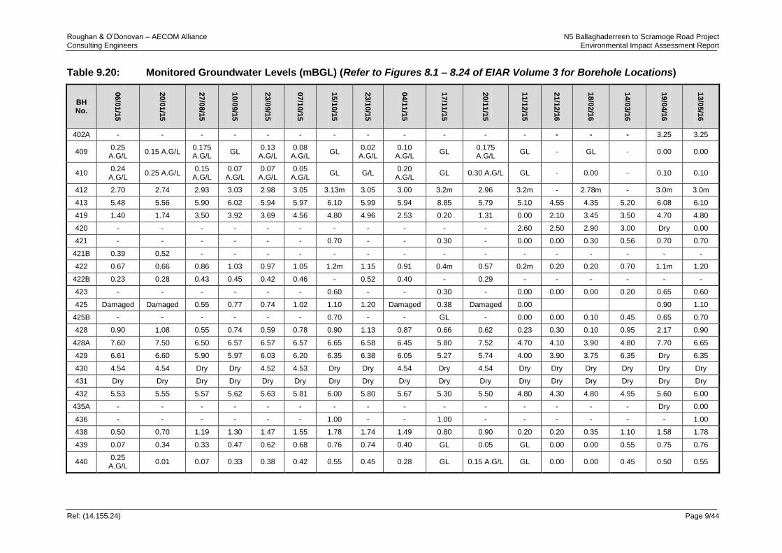
Roughan & O’Donovan – AECOM Alliance N5 Ballaghaderreen to Scramoge Road Project Consulting Engineers Environmental Impact Assessment Report
Ref: (14.155.24) Page 9/44
Table 9.20: Monitored Groundwater Levels (mBGL) (Refer to Figures 8.1 – 8.24 of EIAR Volume 3 for Borehole Locations)
BH No.
06/0
1/1
5
20/0
1/1
5
27/0
8/1
5
10/0
9/1
5
23/0
9/1
5
07/1
0/1
5
15/1
0/1
5
23/1
0/1
5
04/1
1/1
5
17/1
1/1
5
20/1
1/1
5
11/1
2/1
5
21/1
2/1
6
18/0
2/1
6
14/0
3/1
6
19/0
4/1
6
13/0
5/1
6
402A - - - - - - - - - - - - - - - 3.25 3.25
409 0.25
A.G/L 0.15 A.G/L
0.175 A.G/L
GL 0.13
A.G/L 0.08
A.G/L GL
0.02 A.G/L
0.10 A.G/L
GL 0.175 A.G/L
GL - GL - 0.00 0.00
410 0.24
A.G/L 0.25 A.G/L
0.15 A.G/L
0.07 A.G/L
0.07 A.G/L
0.05 A.G/L
GL G/L 0.20
A.G/L GL 0.30 A.G/L GL - 0.00 - 0.10 0.10
412 2.70 2.74 2.93 3.03 2.98 3.05 3.13m 3.05 3.00 3.2m 2.96 3.2m - 2.78m - 3.0m 3.0m
413 5.48 5.56 5.90 6.02 5.94 5.97 6.10 5.99 5.94 8.85 5.79 5.10 4.55 4.35 5.20 6.08 6.10
419 1.40 1.74 3.50 3.92 3.69 4.56 4.80 4.96 2.53 0.20 1.31 0.00 2.10 3.45 3.50 4.70 4.80
420 - - - - - - - - - - - 2.60 2.50 2.90 3.00 Dry 0.00
421 - - - - - - 0.70 - - 0.30 - 0.00 0.00 0.30 0.56 0.70 0.70
421B 0.39 0.52 - - - - - - - - - - - - - - -
422 0.67 0.66 0.86 1.03 0.97 1.05 1.2m 1.15 0.91 0.4m 0.57 0.2m 0.20 0.20 0.70 1.1m 1.20
422B 0.23 0.28 0.43 0.45 0.42 0.46 - 0.52 0.40 - 0.29 - - - - - -
423 - - - - - - 0.60 - - 0.30 - 0.00 0.00 0.00 0.20 0.65 0.60
425 Damaged Damaged 0.55 0.77 0.74 1.02 1.10 1.20 Damaged 0.38 Damaged 0.00
0.90 1.10
425B - - - - - - 0.70 - - GL - 0.00 0.00 0.10 0.45 0.65 0.70
428 0.90 1.08 0.55 0.74 0.59 0.78 0.90 1.13 0.87 0.66 0.62 0.23 0.30 0.10 0.95 2.17 0.90
428A 7.60 7.50 6.50 6.57 6.57 6.57 6.65 6.58 6.45 5.80 7.52 4.70 4.10 3.90 4.80 7.70 6.65
429 6.61 6.60 5.90 5.97 6.03 6.20 6.35 6.38 6.05 5.27 5.74 4.00 3.90 3.75 6.35 Dry 6.35
430 4.54 4.54 Dry Dry 4.52 4.53 Dry Dry 4.54 Dry 4.54 Dry Dry Dry Dry Dry Dry
431 Dry Dry Dry Dry Dry Dry Dry Dry Dry Dry Dry Dry Dry Dry Dry Dry Dry
432 5.53 5.55 5.57 5.62 5.63 5.81 6.00 5.80 5.67 5.30 5.50 4.80 4.30 4.80 4.95 5.60 6.00
435A - - - - - - - - - - - - - - - Dry 0.00
436 - - - - - - 1.00 - - 1.00 - - - - - - 1.00
438 0.50 0.70 1.19 1.30 1.47 1.55 1.78 1.74 1.49 0.80 0.90 0.20 0.20 0.35 1.10 1.58 1.78
439 0.07 0.34 0.33 0.47 0.62 0.68 0.76 0.74 0.40 GL 0.05 GL 0.00 0.00 0.55 0.75 0.76
440 0.25
A.G/L 0.01 0.07 0.33 0.38 0.42 0.55 0.45 0.28 GL 0.15 A.G/L GL 0.00 0.00 0.45 0.50 0.55

Roughan & O’Donovan – AECOM Alliance N5 Ballaghaderreen to Scramoge Road Project Consulting Engineers Environmental Impact Assessment Report
Ref: (14.155.24) Page 9/45
BH No.
06/0
1/1
5
20/0
1/1
5
27/0
8/1
5
10/0
9/1
5
23/0
9/1
5
07/1
0/1
5
15/1
0/1
5
23/1
0/1
5
04/1
1/1
5
17/1
1/1
5
20/1
1/1
5
11/1
2/1
5
21/1
2/1
6
18/0
2/1
6
14/0
3/1
6
19/0
4/1
6
13/0
5/1
6
441 0.30 0.33 0.39 0.41 0.44 0.49 0.63 0.65 0.40 0.10 0.34 0.00 0.00 0.25 0.33 0.75 0.63
442 0.20
A.G/L 0.14 A.G/L 0.05 0.09 0.16 0.12 0.90 0.09 0.05 0.30 0.13 A.G/L 0.00 0.10 0.15 0.26 0.40 0.90
444 0.95 2.73 4.72 5.12 5.50 5.71 6.00 6.00 4.20 0.90 2.45 0.70 0.54 0.90 3.68 5.70 6.00
449 0.30 0.40 2.64 4.55 4.99 6.13 6.60 6.20 4.20 0.40 2.30 0.23 0.18 2.11 3.67 7.00 6.60
450 0.29 0.46 2.56 3.83 3.83 3.83 Dry 3.83 1.75 0.40 0.85 0.19 0.30 0.76 2.78 3.67 Dry
451 - - - - - - 1.20 - - 0.20 - 0.00 0.22 1.10 0.95 1.00 1.20
452 - - 4.27 5.40 5.52 5.66 5.85 5.86 4.75 3.25 3.80 2.80 2.25 2.10 3.67 4.80 5.85
453 15.65 15.65 12.05 12.07 15.67 15.67 Dry 15.67 15.67 Dry 15.65 Dry Dry Dry Dry Dry Dry
459 19.58 19.58 19.55 19.60 19.60 19.63 Dry 19.55 19.55 Dry 19.60 Dry Dry Dry Dry Dry Dry
459A - - - - - - - - - - - - - - - 7.50 0.00
460 14.90 14.90 14.91 14.92 14.87 14.93 Dry 14.90 14.90 Dry 14.90 Dry Dry Dry Dry Dry Dry
461 - - - - - - Dry - - Dry - Dry Dry Dry Dry Dry -
471 - - - - - - - - - - - - - - - - -
476 - - - - - - 0.30 - - GL - 0.00 - - - 0.76 -
478 - - - - - - - - - - - - - - - 2.52 -
479A - - - - - - - - - - - - - - 2.62 2.62 2.62
479B - - - - - - - - - - - - - - 4.70 4.65 4.70
479C - - - - - - - - - - - - - - 3.00 3.00 3.00
480 - - - - - - 1.10 - - GL - - - - - - -
480A - - - - - - - - - - - - - - 3.38 - 3.54
480B - - - - - - - - - - - - - - 3.60 - 3.80
80D - - - - - - - - - 4.30 - - - - - - -
481 - - - - - - - - - - - - - - - - 7.23
481A - - - - - - - - - - - - - - - - 0.30
482 - - - - - - - - - - - - - - - - 4.90
483 - - - - - - - - - - - - - - - - 0.95
483A - - - - - - - - - - - - - - - - 0.65
486A - - - - - - - - - - - - - - - - 1.54
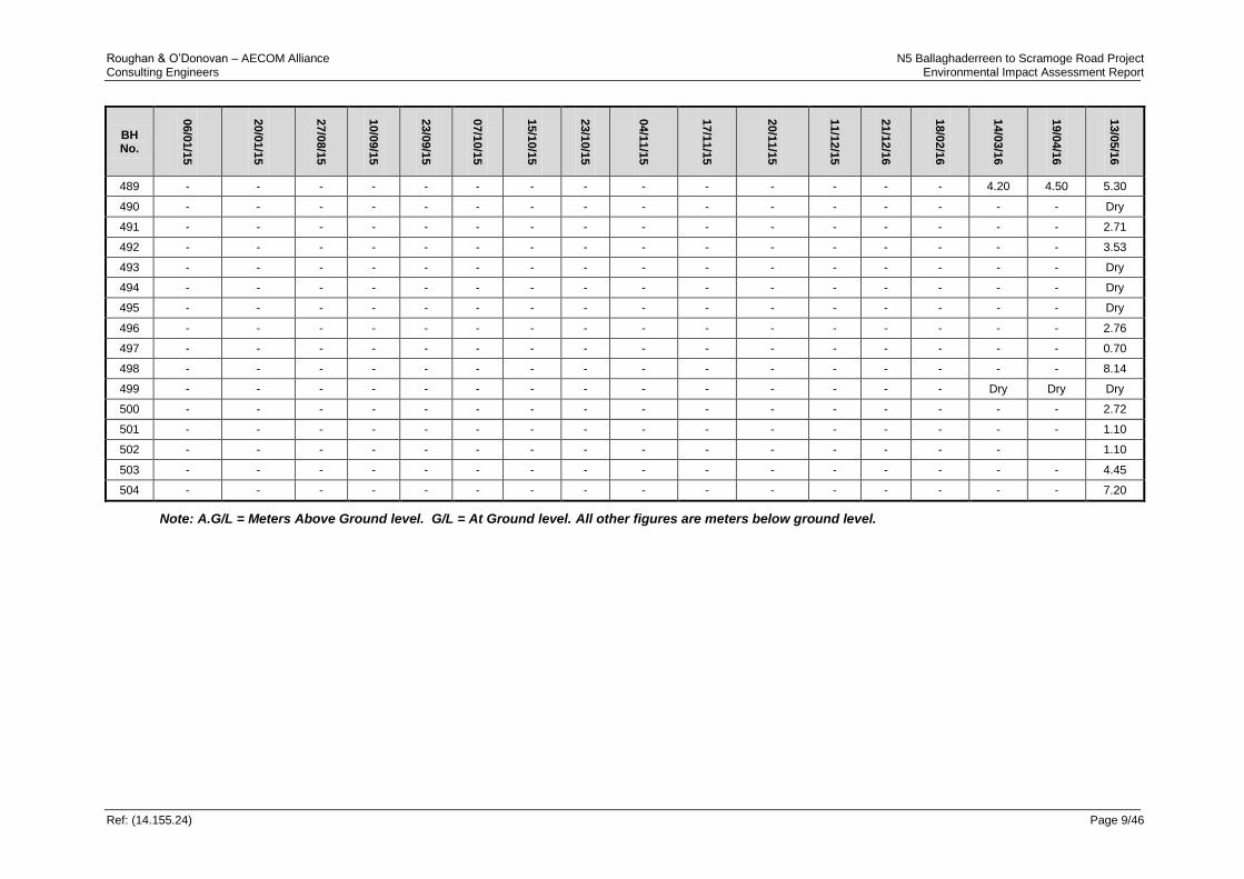
Roughan & O’Donovan – AECOM Alliance N5 Ballaghaderreen to Scramoge Road Project Consulting Engineers Environmental Impact Assessment Report
Ref: (14.155.24) Page 9/46
BH No.
06/0
1/1
5
20/0
1/1
5
27/0
8/1
5
10/0
9/1
5
23/0
9/1
5
07/1
0/1
5
15/1
0/1
5
23/1
0/1
5
04/1
1/1
5
17/1
1/1
5
20/1
1/1
5
11/1
2/1
5
21/1
2/1
6
18/0
2/1
6
14/0
3/1
6
19/0
4/1
6
13/0
5/1
6
489 - - - - - - - - - - - - - - 4.20 4.50 5.30
490 - - - - - - - - - - - - - - - - Dry
491 - - - - - - - - - - - - - - - - 2.71
492 - - - - - - - - - - - - - - - - 3.53
493 - - - - - - - - - - - - - - - - Dry
494 - - - - - - - - - - - - - - - - Dry
495 - - - - - - - - - - - - - - - - Dry
496 - - - - - - - - - - - - - - - - 2.76
497 - - - - - - - - - - - - - - - - 0.70
498 - - - - - - - - - - - - - - - - 8.14
499 - - - - - - - - - - - - - - Dry Dry Dry
500 - - - - - - - - - - - - - - - - 2.72
501 - - - - - - - - - - - - - - - - 1.10
502 - - - - - - - - - - - - - - -
1.10
503 - - - - - - - - - - - - - - - - 4.45
504 - - - - - - - - - - - - - - - - 7.20
Note: A.G/L = Meters Above Ground level. G/L = At Ground level. All other figures are meters below ground level.

Roughan & O’Donovan – AECOM Alliance N5 Ballaghaderreen to Scramoge Road Project Consulting Engineers Environmental Impact Assessment Report
Ref: (14.155.24) Page 9/47
9.4 Potential Impact Assessment
9.4.1 Methodology
Road projects given their scale and nature have significant potential for causing impact to the groundwater environment both during their construction and their on-going operation and consequently require careful planning and detailed assessment to ensure the best solution is attained. This assessment of hydrogeological impacts for the proposed road development has been based on the analysis and interpretation of the data acquired during the Constraints Study and Route Corridor Selection phases, as well as site specific investigations undertaken as part of the Design, EIAR and NIS, including the ecological study, intrusive site investigation, agricultural survey and hydrogeological investigations. The procedure follows guidelines established by the TII/NRA in its ‘Guidelines on Procedures for Assessment and Treatment of Geology, Hydrology and Hydrogeology for National Road Schemes and the TII/NRA DN-DNG-03065 Road Drainage and the Water Environment’. Key hydrogeological attributes that have been considered along the proposed road alignment include:
High yielding springs and wells used for groundwater supply and their surrounding Source Protection Zones (SPZs);
Low-yielding wells used mainly for domestic and farm water supply; and
Any significant natural hydrogeological features (including large springs or groundwater dependent habitats);
The dominant hydrogeological characteristics (aquifer classification) of the underlying strata;
Sensitive karst features and groundwater systems. The individual importance of these attributes has been then assessed with respect to their quality, extent / scale and rarity (Table 9.21). Table 9.21: Criteria for Rating Site Attributes
Importance Criteria
Extremely High Attribute has a high quality or value on an international scale
Very High Attribute has a high quality or value on a regional or national scale
High Attribute has a high quality or value on a local scale
Medium Attribute has a medium quality or value on a local scale
Low Attribute has a low quality or value on a local scale
For the purposes of this assessment and particularly with reference to the identified KERs and how their importance was rated from the ecological perspective (see Chapter 7), the following rating criteria were used in respect to the attribute values :
Local Importance Lower value - Low
Local Importance Higher value – Medium
County/ Regionally Important – High
National Importance – Very high
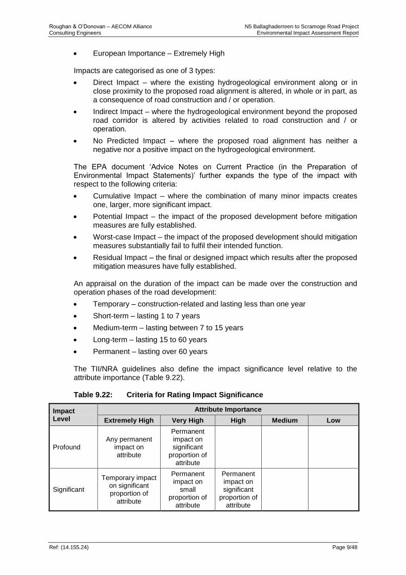
Roughan & O’Donovan – AECOM Alliance N5 Ballaghaderreen to Scramoge Road Project Consulting Engineers Environmental Impact Assessment Report
Ref: (14.155.24) Page 9/48
European Importance – Extremely High Impacts are categorised as one of 3 types:
Direct Impact – where the existing hydrogeological environment along or in close proximity to the proposed road alignment is altered, in whole or in part, as a consequence of road construction and / or operation.
Indirect Impact – where the hydrogeological environment beyond the proposed road corridor is altered by activities related to road construction and / or operation.
No Predicted Impact – where the proposed road alignment has neither a negative nor a positive impact on the hydrogeological environment.
The EPA document ‘Advice Notes on Current Practice (in the Preparation of Environmental Impact Statements)’ further expands the type of the impact with respect to the following criteria:
Cumulative Impact – where the combination of many minor impacts creates one, larger, more significant impact.
Potential Impact – the impact of the proposed development before mitigation measures are fully established.
Worst-case Impact – the impact of the proposed development should mitigation measures substantially fail to fulfil their intended function.
Residual Impact – the final or designed impact which results after the proposed mitigation measures have fully established.
An appraisal on the duration of the impact can be made over the construction and operation phases of the road development:
Temporary – construction-related and lasting less than one year
Short-term – lasting 1 to 7 years
Medium-term – lasting between 7 to 15 years
Long-term – lasting 15 to 60 years
Permanent – lasting over 60 years The TII/NRA guidelines also define the impact significance level relative to the attribute importance (Table 9.22). Table 9.22: Criteria for Rating Impact Significance
Impact Level
Attribute Importance
Extremely High Very High High Medium Low
Profound Any permanent
impact on attribute
Permanent impact on significant
proportion of attribute
Significant
Temporary impact on significant proportion of
attribute
Permanent impact on
small proportion of
attribute
Permanent impact on significant
proportion of attribute
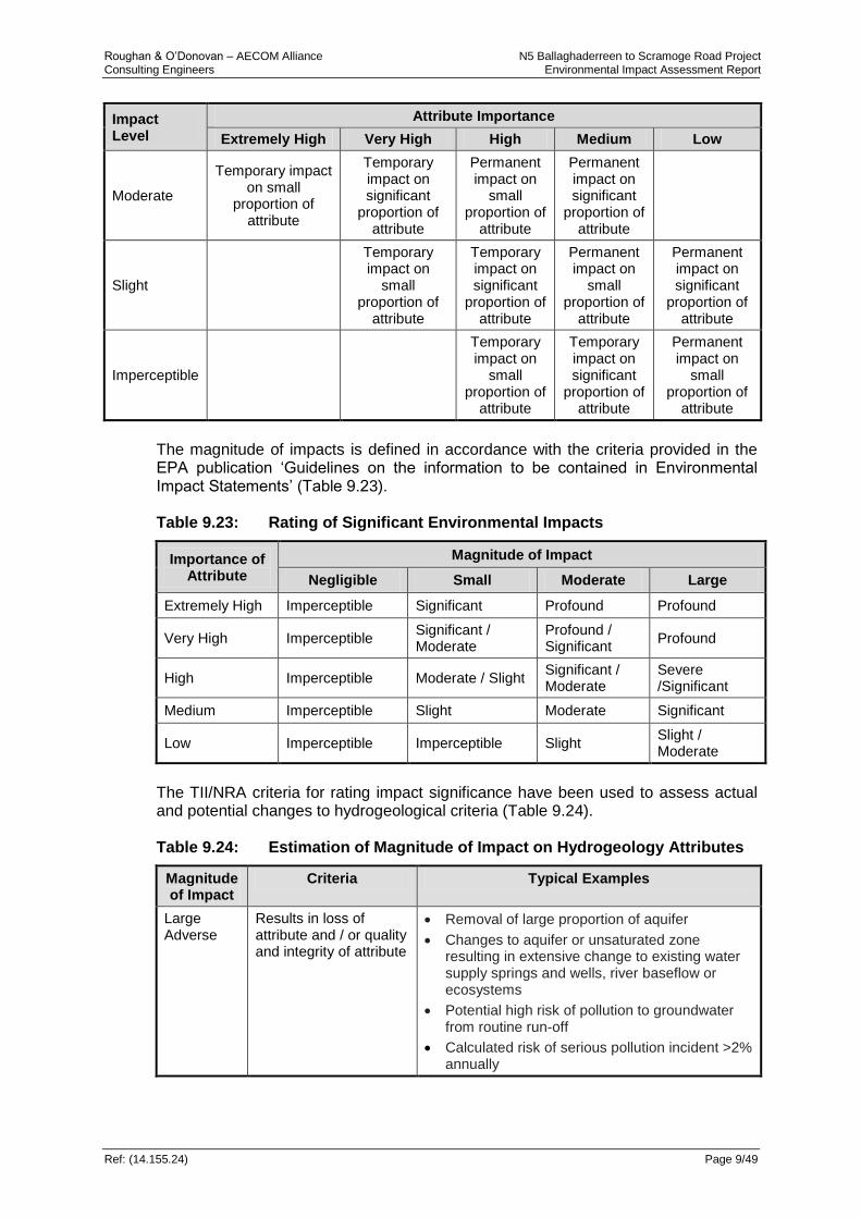
Roughan & O’Donovan – AECOM Alliance N5 Ballaghaderreen to Scramoge Road Project Consulting Engineers Environmental Impact Assessment Report
Ref: (14.155.24) Page 9/49
Impact Level
Attribute Importance
Extremely High Very High High Medium Low
Moderate
Temporary impact on small
proportion of attribute
Temporary impact on significant
proportion of attribute
Permanent impact on
small proportion of
attribute
Permanent impact on significant
proportion of attribute
Slight
Temporary impact on
small proportion of
attribute
Temporary impact on significant
proportion of attribute
Permanent impact on
small proportion of
attribute
Permanent impact on significant
proportion of attribute
Imperceptible
Temporary impact on
small proportion of
attribute
Temporary impact on significant
proportion of attribute
Permanent impact on
small proportion of
attribute
The magnitude of impacts is defined in accordance with the criteria provided in the EPA publication ‘Guidelines on the information to be contained in Environmental Impact Statements’ (Table 9.23). Table 9.23: Rating of Significant Environmental Impacts
Importance of Attribute
Magnitude of Impact
Negligible Small Moderate Large
Extremely High Imperceptible Significant Profound Profound
Very High Imperceptible Significant / Moderate
Profound / Significant
Profound
High Imperceptible Moderate / Slight Significant / Moderate
Severe /Significant
Medium Imperceptible Slight Moderate Significant
Low Imperceptible Imperceptible Slight Slight / Moderate
The TII/NRA criteria for rating impact significance have been used to assess actual and potential changes to hydrogeological criteria (Table 9.24). Table 9.24: Estimation of Magnitude of Impact on Hydrogeology Attributes
Magnitude of Impact
Criteria Typical Examples
Large Adverse
Results in loss of attribute and / or quality and integrity of attribute
Removal of large proportion of aquifer
Changes to aquifer or unsaturated zone resulting in extensive change to existing water supply springs and wells, river baseflow or ecosystems
Potential high risk of pollution to groundwater from routine run-off
Calculated risk of serious pollution incident >2% annually
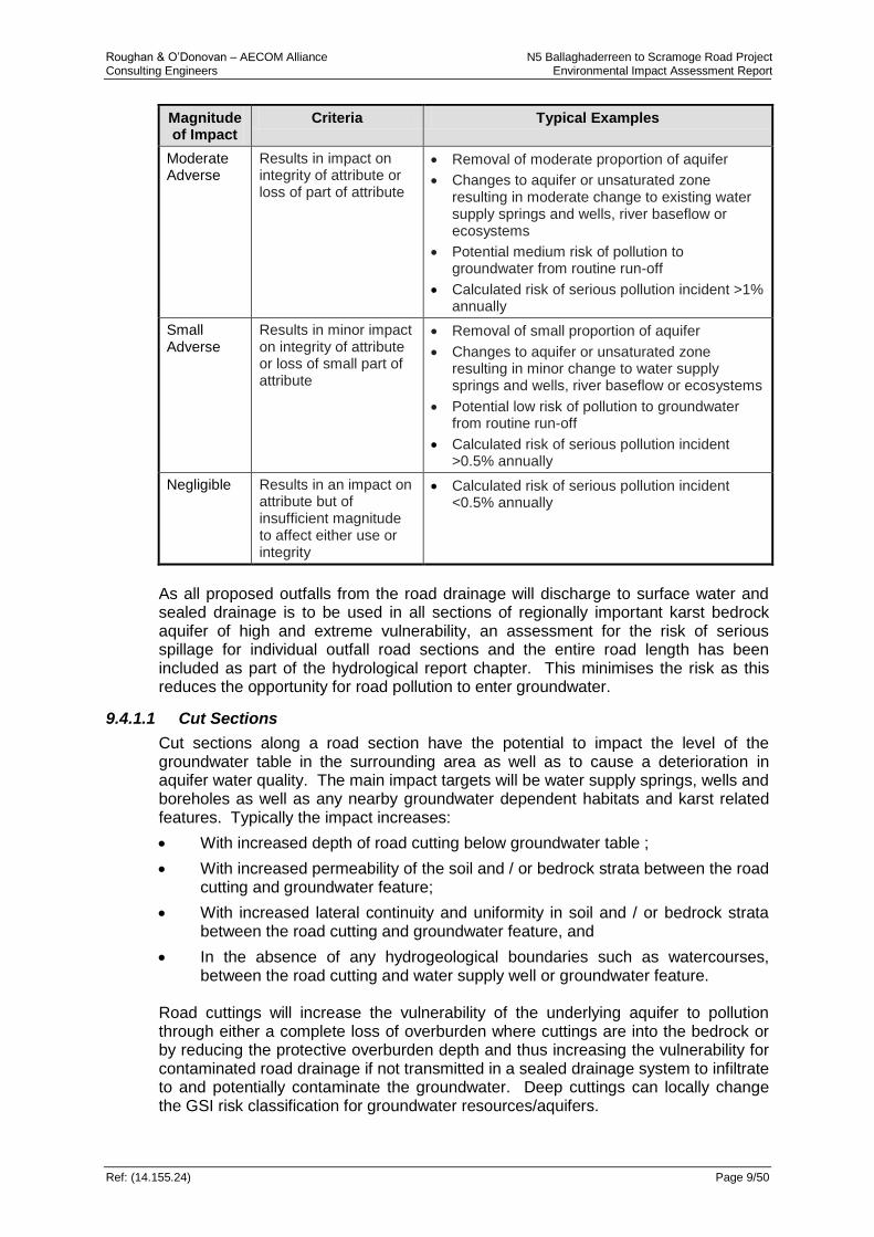
Roughan & O’Donovan – AECOM Alliance N5 Ballaghaderreen to Scramoge Road Project Consulting Engineers Environmental Impact Assessment Report
Ref: (14.155.24) Page 9/50
Magnitude of Impact
Criteria Typical Examples
Moderate Adverse
Results in impact on integrity of attribute or loss of part of attribute
Removal of moderate proportion of aquifer
Changes to aquifer or unsaturated zone resulting in moderate change to existing water supply springs and wells, river baseflow or ecosystems
Potential medium risk of pollution to groundwater from routine run-off
Calculated risk of serious pollution incident >1% annually
Small Adverse
Results in minor impact on integrity of attribute or loss of small part of attribute
Removal of small proportion of aquifer
Changes to aquifer or unsaturated zone resulting in minor change to water supply springs and wells, river baseflow or ecosystems
Potential low risk of pollution to groundwater from routine run-off
Calculated risk of serious pollution incident >0.5% annually
Negligible Results in an impact on attribute but of insufficient magnitude to affect either use or integrity
Calculated risk of serious pollution incident <0.5% annually
As all proposed outfalls from the road drainage will discharge to surface water and sealed drainage is to be used in all sections of regionally important karst bedrock aquifer of high and extreme vulnerability, an assessment for the risk of serious spillage for individual outfall road sections and the entire road length has been included as part of the hydrological report chapter. This minimises the risk as this reduces the opportunity for road pollution to enter groundwater.
9.4.1.1 Cut Sections
Cut sections along a road section have the potential to impact the level of the groundwater table in the surrounding area as well as to cause a deterioration in aquifer water quality. The main impact targets will be water supply springs, wells and boreholes as well as any nearby groundwater dependent habitats and karst related features. Typically the impact increases:
With increased depth of road cutting below groundwater table ;
With increased permeability of the soil and / or bedrock strata between the road cutting and groundwater feature;
With increased lateral continuity and uniformity in soil and / or bedrock strata between the road cutting and groundwater feature, and
In the absence of any hydrogeological boundaries such as watercourses, between the road cutting and water supply well or groundwater feature.
Road cuttings will increase the vulnerability of the underlying aquifer to pollution through either a complete loss of overburden where cuttings are into the bedrock or by reducing the protective overburden depth and thus increasing the vulnerability for contaminated road drainage if not transmitted in a sealed drainage system to infiltrate to and potentially contaminate the groundwater. Deep cuttings can locally change the GSI risk classification for groundwater resources/aquifers.

Roughan & O’Donovan – AECOM Alliance N5 Ballaghaderreen to Scramoge Road Project Consulting Engineers Environmental Impact Assessment Report
Ref: (14.155.24) Page 9/51
A summary of the main cut sections along the proposed development together with the aquifer vulnerability is given in see Table 9.25. Extensive road cuttings can if not mitigated significantly increase the runoff volume to be conveyed within the road drainage system and the volume to be ultimately discharged to receiving waters at road drainage outfalls. This can have an adverse effect on the receiving waters in terms of chemistry and water balance. Groundwater quality can be indirectly impacted if drainage systems are not adequately designed and maintained, to ensure conveyance of potentially contaminated surface run-off through these areas in sealed drains / channels where fissured/weathered bedrock is exposed and the aquifer is a regionally important karst bedrock aquifer. Cut sections can impact potential groundwater recharge and cause dewatering of the intercepted aquifer. There is also the potential to intercept and truncate high yielding groundwater flows within the karst aquifer. It is assumed that where deep cut sections are located along the proposed road alignment, there will always be a direct potential temporary impact to the quality of the underlying aquifer during the construction phase and until appropriate measures are in place to prevent infiltration of contaminated run-off and drainage waters. However in terms of the flow regime, there is the potential for a permanent impact on the underlying aquifer which will remain during the operational phase. Cut sections will reduce the depth of subsoil from particular areas along the proposed road alignment. This will have a localised effect on the groundwater vulnerability rating, as the pathway for potential contaminants to migrate into the underlying aquifer is shortened. Areas where bedrock is at or close to surface will be particularly sensitive. An assessment in relation to hydrogeological aspects at all significant proposed cut sections as outlined in 9.25 is given in Table 9.26. Table 9.25: Significant Cut Sections Along Proposed Road Alignment
Chainage
Maximum Cut depth
(m)
Depth to bedrock (mbgl)
Hydrogeological Comments
13+000 -13+800
10.9 0 - 2.9 Extreme groundwater vulnerability; Locally Important Aquifer. Groundwater table likely to be intercepted.
18+800 – 20+600
6.6 1 – 5.9 High/Extreme groundwater vulnerability; Regionally Important Karstified Aquifer. Possible interception of groundwater at this location.
22+000 – 22+600
4.2 3.7 – 6.2 High to moderate groundwater vulnerability Regionally Important Aquifer. Unlikely to encounter groundwater at this location.
23+250 – 30+450
8.6 3.7 - 5.7
High to moderate groundwater vulnerability. Regionally Important Karstified aquifer. Groundwater not likely to be encountered at this location.
30+000 – 30+500
7.8 3 – 6
High groundwater vulnerability.
Regionally Important Karstified aquifer.
This cut may intercept groundwater.
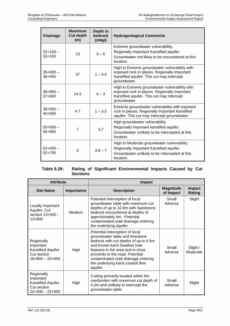
Roughan & O’Donovan – AECOM Alliance N5 Ballaghaderreen to Scramoge Road Project Consulting Engineers Environmental Impact Assessment Report
Ref: (14.155.24) Page 9/52
Chainage
Maximum Cut depth
(m)
Depth to bedrock (mbgl)
Hydrogeological Comments
32+100 – 33+100
13 0 – 5
Extreme groundwater vulnerability.
Regionally Important Karstified aquifer.
Groundwater not likely to be encountered at this location.
35+600 – 36+450
27 1 – 4.4
High to Extreme groundwater vulnerability with exposed rock in places. Regionally Important Karstified aquifer. This cut may intercept groundwater.
36+850 – 37+600
14.5 0 – 3
High to Extreme groundwater vulnerability with exposed rock in places. Regionally Important Karstified aquifer. This cut may intercept groundwater.
39+650 – 40+050
4.7 1 – 3.5 Extreme groundwater vulnerability with exposed rock in places. Regionally Important Karstified aquifer. This cut may intercept groundwater.
50+000 – 50+650
7 3.7
High groundwater vulnerability.
Regionally Important karstified aquifer.
Groundwater unlikely to be intercepted at this location.
52+450 – 52+700
5 3.8 – 7
High to Moderate groundwater vulnerability.
Regionally Important Karstified aquifer.
Groundwater unlikely to be intercepted at this location.
Table 9.26: Rating of Significant Environmental Impacts Caused by Cut
Sections
Attribute Impact
Site Name Importance Description Magnitude of Impact
Impact Rating
Locally Important Aquifer: Cut section 13+000 -13+800
Medium
Potential interception of local groundwater table with maximum cut depths of up to 10.9m with Sandstone bedrock encountered at depths of approximately 4m. Potential contaminated road drainage entering the underlying aquifer.
Small Adverse
Slight
Regionally Important Karstified Aquifer: Cut section 18+800 – 20+600
High
Potential interception of local groundwater table and limestone bedrock with cut depths of up to 6.6m and known karst Swallow hole features in the area and in close proximity to the road. Potential contaminated road drainage entering the underlying karst conduit flow aquifer.
Small Adverse
Slight / Moderate
Regionally Important Karstified Aquifer: Cut section 22+000 – 22+600
High
Cutting primarily located within the overburden with maximum cut depth of 4.2m and unlikely to intercept the groundwater table.
Small Adverse
Slight
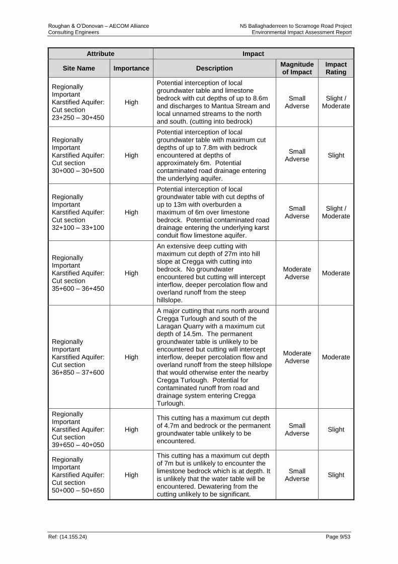
Roughan & O’Donovan – AECOM Alliance N5 Ballaghaderreen to Scramoge Road Project Consulting Engineers Environmental Impact Assessment Report
Ref: (14.155.24) Page 9/53
Attribute Impact
Site Name Importance Description Magnitude of Impact
Impact Rating
Regionally Important Karstified Aquifer: Cut section 23+250 – 30+450
High
Potential interception of local groundwater table and limestone bedrock with cut depths of up to 8.6m and discharges to Mantua Stream and local unnamed streams to the north and south. (cutting into bedrock)
Small Adverse
Slight / Moderate
Regionally Important Karstified Aquifer: Cut section 30+000 – 30+500
High
Potential interception of local groundwater table with maximum cut depths of up to 7.8m with bedrock encountered at depths of approximately 6m. Potential contaminated road drainage entering the underlying aquifer.
Small Adverse
Slight
Regionally Important Karstified Aquifer: Cut section 32+100 – 33+100
High
Potential interception of local groundwater table with cut depths of up to 13m with overburden a maximum of 6m over limestone bedrock. Potential contaminated road drainage entering the underlying karst conduit flow limestone aquifer.
Small Adverse
Slight / Moderate
Regionally Important Karstified Aquifer: Cut section 35+600 – 36+450
High
An extensive deep cutting with maximum cut depth of 27m into hill slope at Cregga with cutting into bedrock. No groundwater encountered but cutting will intercept interflow, deeper percolation flow and overland runoff from the steep hillslope.
Moderate Adverse
Moderate
Regionally Important Karstified Aquifer: Cut section 36+850 – 37+600
High
A major cutting that runs north around Cregga Turlough and south of the Laragan Quarry with a maximum cut depth of 14.5m. The permanent groundwater table is unlikely to be encountered but cutting will intercept interflow, deeper percolation flow and overland runoff from the steep hillslope that would otherwise enter the nearby Cregga Turlough. Potential for contaminated runoff from road and drainage system entering Cregga Turlough.
Moderate Adverse
Moderate
Regionally Important Karstified Aquifer: Cut section 39+650 – 40+050
High
This cutting has a maximum cut depth of 4.7m and bedrock or the permanent groundwater table unlikely to be encountered.
Small Adverse
Slight
Regionally Important Karstified Aquifer: Cut section 50+000 – 50+650
High
This cutting has a maximum cut depth of 7m but is unlikely to encounter the limestone bedrock which is at depth. It is unlikely that the water table will be encountered. Dewatering from the cutting unlikely to be significant.
Small Adverse
Slight

Roughan & O’Donovan – AECOM Alliance N5 Ballaghaderreen to Scramoge Road Project Consulting Engineers Environmental Impact Assessment Report
Ref: (14.155.24) Page 9/54
Attribute Impact
Site Name Importance Description Magnitude of Impact
Impact Rating
Regionally Important Karstified Aquifer: Cut section 52+450 – 52+700
High
This cutting has a maximum cut depth of 5m and is unlikely to encounter the limestone bedrock which is at depth but unlikely to encounter the water table. Dewatering from the cutting unlikely to be significant.
Small Adverse
Slight
9.4.1.2 Embankment Sections
Road embankment sections are required along the route and range from 1m up to 12.3m in height – refer to Table 9.27 for details. In areas of soft ground the soft material must be excavated to depth and replaced by suitable bearing material before the embankment is constructed. Such construction can produce a drainage effect whereby the road formation acts as a wide and potentially deep longitudinal linear drain capable of intercepting, dewatering and conveying flow along the alignment. Table 9.27: Rating Of Significant Environmental Impacts Caused By
Embankment Sections
Chainage (m) Location Maximum Height (m)
Underlying Soil
10+000 – 10+700 Corskeagh, Mullen &
Leggatinty 3.1 Peat, Silt & Glacial Till
12+150 – 12+900 Leggatinty, Derreen &
Cashel 3.7
Glacial Till, Sandstone bedrock
13+800 – 15+700 Ballaghcullia to Peak 6.4 Peat, Glacial Till, overlying
limestone bedrock
21+200 – 21+850 Cartronagor 3.6 Glacial Till
22+750 – 23+150 Creeve 4.0 Glacial Till
30+600 – 32+000 Killeen West & Lurgan 6.5 Peat, silt, glacial till, limestone bedrock
34+500 – 35+075 Tullyloyd & Tullycarton 6.7 Peat, glacial till
34+500 – 35+075 Lugboy 9.2 Glacial till, limestone bedrock
36+475 – 36+875 Cregga & Cuilrevagh 12.3 Glacial till, limestone bedrock
37+675 – 38+150 Cuilrevagh & Tullen 11.8 Glacial till, limestone bedrock
40+150 – 40+500 Lavally 7.3 Glacial till, limestone bedrock
50+800 – 51+250 Vesnoy, Cloonradoon &
Bumlin 7.8
Peat, Glacial till, limestone bedrock
52+800 – 53+400 Scramoge 9.0 Peat, Glacial till, limestone
bedrock
Road embankments by their raised nature can obstruct and divert overland flows which may alter the recharge characteristics of an area. The weight of road embankments may result in the compaction of the native subsoil material under the embankment which would result in the loss of porosity and permeability in the underlying subsoil which could restrict shallow subsurface groundwater flow. In karstified areas the weight of the embankment could potentially

Roughan & O’Donovan – AECOM Alliance N5 Ballaghaderreen to Scramoge Road Project Consulting Engineers Environmental Impact Assessment Report
Ref: (14.155.24) Page 9/55
cause a collapse in the weathered limestone bedrock resulting in potential settlement and drainage issues and conduit flow systems associated with shallow weathered and / or karstified bedrock. Such impacts may have adverse effects on the functioning of nearby aquatic habitat wetland and fen systems through potential drainage effects of the road construction and the potential interception and interference of subsurface flows. Whether the road is at grade or on embankment, areas of soft, compressible organic soils that are generally not suitable as road formation material will have to be removed and replaced by suitable road bearing fill material, that by its nature will be significantly more permeable. This has the potential for the road formation, depending on the vertical alignment and the local topography, to act as a large linear drain which could potentially dewater the surrounding overburden and intercept and divert the natural interflow, and groundwater flows. This drainage effect by the road formation on the surrounding overburden can have a significant adverse impact through potentially drying of nearby wetland habitats such as Blanket bog, wet heath and wet grassland including Molina Meadows. There are a number of locations, predominantly towards the west end of the road development where sensitive wetland habitats adjacent to the road are at risk of such impact from potential drainage effects by the permeable road formation layer. Further areas towards the east at Tullyloyd Fen and Cregga Turlough are also identified as vulnerable to such impacts in terms of the recharge to these features/habitats. The hydrogeological impact of road embankments and at-grade sections as a result of excavation of soft material and replacement by more permeable bearing material or where local drainage channels are modified as a result of the road development (culverting, diversions and truncation of drains, provision of new drains and deepening/widening of existing drains) are generally imperceptible at the catchment and sub-catchment scale but at the local site drainage scale can represent moderate to significant changes in the drainage pattern. Such changes could have an impact on nearby sensitive terrestrial wetland habitats including raised Bog Peatlands (cutover, eroding and intact Blanket Bog) wet heath and wet grassland including Annex I Molina Meadows habitat and groundwater fed fen habitats.
9.4.1.3 Impact on Natural Heritage
European Designated Sites (SAC/SPA)
An assessment of the potential impact for European Designated Sites which were “screened in” during the Screening for Appropriate Assessment was carried out and is summarised in Table 9.28 below. None of the designated sites are assessed to be close enough to produce any perceptible groundwater regime changes from the proposed development and have therefore been assessed as having an impact rating of imperceptible.
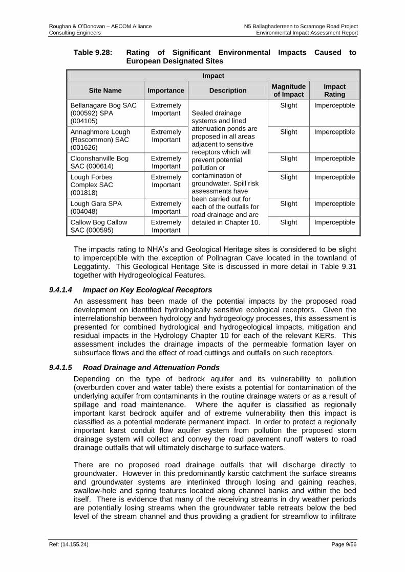
Roughan & O’Donovan – AECOM Alliance N5 Ballaghaderreen to Scramoge Road Project Consulting Engineers Environmental Impact Assessment Report
Ref: (14.155.24) Page 9/56
Table 9.28: Rating of Significant Environmental Impacts Caused to European Designated Sites
Impact
Site Name Importance Description Magnitude of Impact
Impact Rating
Bellanagare Bog SAC (000592) SPA (004105)
Extremely Important Sealed drainage
systems and lined attenuation ponds are proposed in all areas adjacent to sensitive receptors which will prevent potential pollution or contamination of groundwater. Spill risk assessments have been carried out for each of the outfalls for road drainage and are detailed in Chapter 10.
Slight Imperceptible
Annaghmore Lough (Roscommon) SAC (001626)
Extremely Important
Slight Imperceptible
Cloonshanville Bog SAC (000614)
Extremely Important
Slight Imperceptible
Lough Forbes Complex SAC (001818)
Extremely Important
Slight Imperceptible
Lough Gara SPA (004048)
Extremely Important
Slight Imperceptible
Callow Bog Callow SAC (000595)
Extremely Important
Slight Imperceptible
The impacts rating to NHA’s and Geological Heritage sites is considered to be slight to imperceptible with the exception of Pollnagran Cave located in the townland of Leggatinty. This Geological Heritage Site is discussed in more detail in Table 9.31 together with Hydrogeological Features.
9.4.1.4 Impact on Key Ecological Receptors
An assessment has been made of the potential impacts by the proposed road development on identified hydrologically sensitive ecological receptors. Given the interrelationship between hydrology and hydrogeology processes, this assessment is presented for combined hydrological and hydrogeological impacts, mitigation and residual impacts in the Hydrology Chapter 10 for each of the relevant KERs. This assessment includes the drainage impacts of the permeable formation layer on subsurface flows and the effect of road cuttings and outfalls on such receptors.
9.4.1.5 Road Drainage and Attenuation Ponds
Depending on the type of bedrock aquifer and its vulnerability to pollution (overburden cover and water table) there exists a potential for contamination of the underlying aquifer from contaminants in the routine drainage waters or as a result of spillage and road maintenance. Where the aquifer is classified as regionally important karst bedrock aquifer and of extreme vulnerability then this impact is classified as a potential moderate permanent impact. In order to protect a regionally important karst conduit flow aquifer system from pollution the proposed storm drainage system will collect and convey the road pavement runoff waters to road drainage outfalls that will ultimately discharge to surface waters. There are no proposed road drainage outfalls that will discharge directly to groundwater. However in this predominantly karstic catchment the surface streams and groundwater systems are interlinked through losing and gaining reaches, swallow-hole and spring features located along channel banks and within the bed itself. There is evidence that many of the receiving streams in dry weather periods are potentially losing streams when the groundwater table retreats below the bed level of the stream channel and thus providing a gradient for streamflow to infiltrate
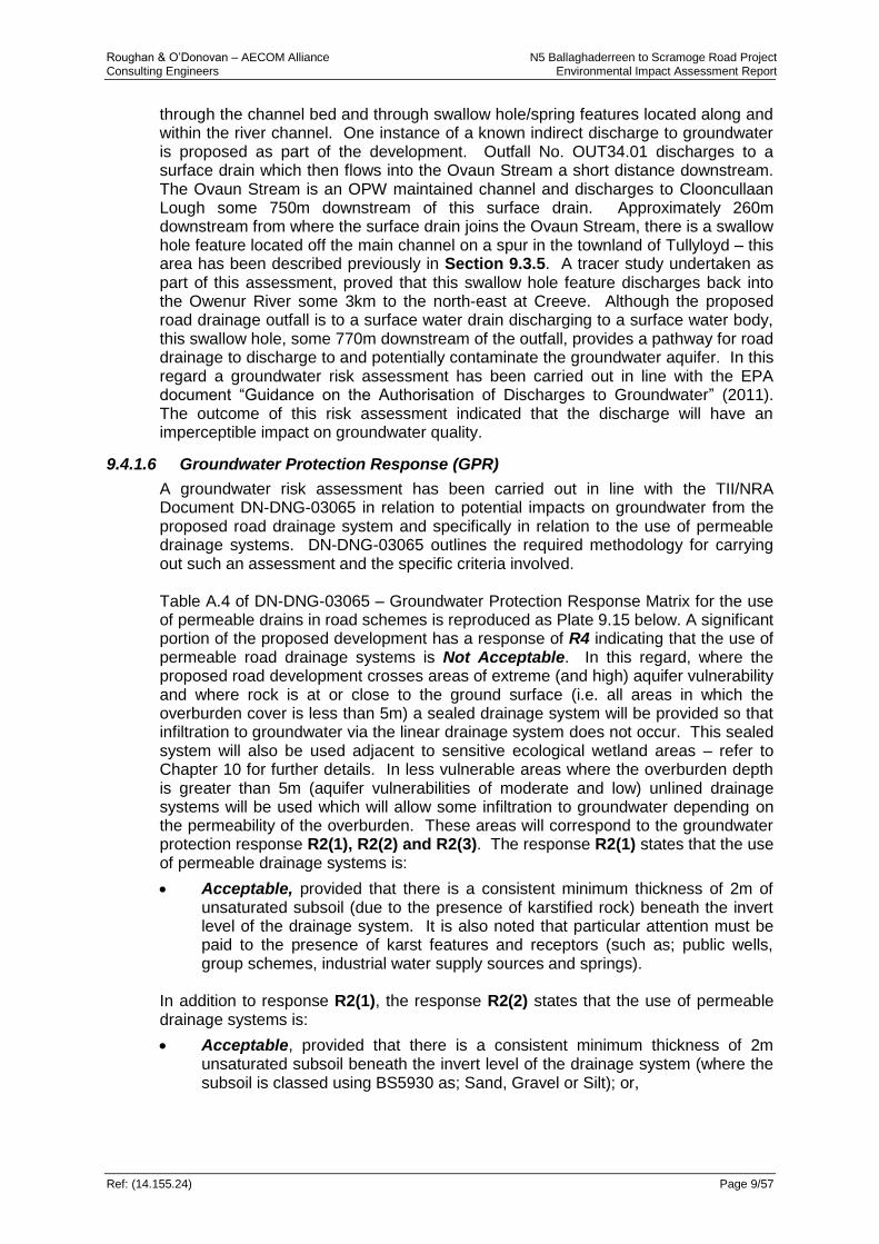
Roughan & O’Donovan – AECOM Alliance N5 Ballaghaderreen to Scramoge Road Project Consulting Engineers Environmental Impact Assessment Report
Ref: (14.155.24) Page 9/57
through the channel bed and through swallow hole/spring features located along and within the river channel. One instance of a known indirect discharge to groundwater is proposed as part of the development. Outfall No. OUT34.01 discharges to a surface drain which then flows into the Ovaun Stream a short distance downstream. The Ovaun Stream is an OPW maintained channel and discharges to Clooncullaan Lough some 750m downstream of this surface drain. Approximately 260m downstream from where the surface drain joins the Ovaun Stream, there is a swallow hole feature located off the main channel on a spur in the townland of Tullyloyd – this area has been described previously in Section 9.3.5. A tracer study undertaken as part of this assessment, proved that this swallow hole feature discharges back into the Owenur River some 3km to the north-east at Creeve. Although the proposed road drainage outfall is to a surface water drain discharging to a surface water body, this swallow hole, some 770m downstream of the outfall, provides a pathway for road drainage to discharge to and potentially contaminate the groundwater aquifer. In this regard a groundwater risk assessment has been carried out in line with the EPA document “Guidance on the Authorisation of Discharges to Groundwater” (2011). The outcome of this risk assessment indicated that the discharge will have an imperceptible impact on groundwater quality.
9.4.1.6 Groundwater Protection Response (GPR)
A groundwater risk assessment has been carried out in line with the TII/NRA Document DN-DNG-03065 in relation to potential impacts on groundwater from the proposed road drainage system and specifically in relation to the use of permeable drainage systems. DN-DNG-03065 outlines the required methodology for carrying out such an assessment and the specific criteria involved. Table A.4 of DN-DNG-03065 – Groundwater Protection Response Matrix for the use of permeable drains in road schemes is reproduced as Plate 9.15 below. A significant portion of the proposed development has a response of R4 indicating that the use of permeable road drainage systems is Not Acceptable. In this regard, where the proposed road development crosses areas of extreme (and high) aquifer vulnerability and where rock is at or close to the ground surface (i.e. all areas in which the overburden cover is less than 5m) a sealed drainage system will be provided so that infiltration to groundwater via the linear drainage system does not occur. This sealed system will also be used adjacent to sensitive ecological wetland areas – refer to Chapter 10 for further details. In less vulnerable areas where the overburden depth is greater than 5m (aquifer vulnerabilities of moderate and low) unlined drainage systems will be used which will allow some infiltration to groundwater depending on the permeability of the overburden. These areas will correspond to the groundwater protection response R2(1), R2(2) and R2(3). The response R2(1) states that the use of permeable drainage systems is:
Acceptable, provided that there is a consistent minimum thickness of 2m of unsaturated subsoil (due to the presence of karstified rock) beneath the invert level of the drainage system. It is also noted that particular attention must be paid to the presence of karst features and receptors (such as; public wells, group schemes, industrial water supply sources and springs).
In addition to response R2(1), the response R2(2) states that the use of permeable drainage systems is:
Acceptable, provided that there is a consistent minimum thickness of 2m unsaturated subsoil beneath the invert level of the drainage system (where the subsoil is classed using BS5930 as; Sand, Gravel or Silt); or,
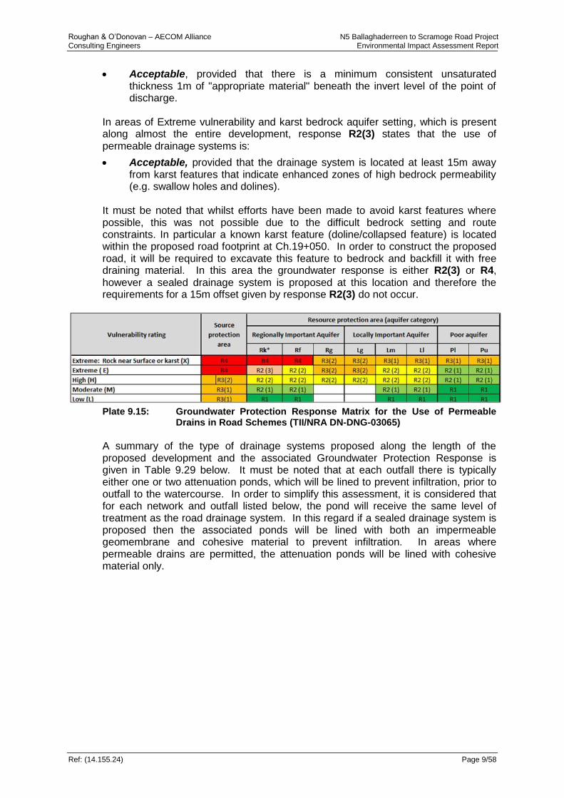
Roughan & O’Donovan – AECOM Alliance N5 Ballaghaderreen to Scramoge Road Project Consulting Engineers Environmental Impact Assessment Report
Ref: (14.155.24) Page 9/58
Acceptable, provided that there is a minimum consistent unsaturated thickness 1m of "appropriate material" beneath the invert level of the point of discharge.
In areas of Extreme vulnerability and karst bedrock aquifer setting, which is present along almost the entire development, response R2(3) states that the use of permeable drainage systems is:
Acceptable, provided that the drainage system is located at least 15m away from karst features that indicate enhanced zones of high bedrock permeability (e.g. swallow holes and dolines).
It must be noted that whilst efforts have been made to avoid karst features where possible, this was not possible due to the difficult bedrock setting and route constraints. In particular a known karst feature (doline/collapsed feature) is located within the proposed road footprint at Ch.19+050. In order to construct the proposed road, it will be required to excavate this feature to bedrock and backfill it with free draining material. In this area the groundwater response is either R2(3) or R4, however a sealed drainage system is proposed at this location and therefore the requirements for a 15m offset given by response R2(3) do not occur.
Plate 9.15: Groundwater Protection Response Matrix for the Use of Permeable
Drains in Road Schemes (TII/NRA DN-DNG-03065)
A summary of the type of drainage systems proposed along the length of the proposed development and the associated Groundwater Protection Response is given in Table 9.29 below. It must be noted that at each outfall there is typically either one or two attenuation ponds, which will be lined to prevent infiltration, prior to outfall to the watercourse. In order to simplify this assessment, it is considered that for each network and outfall listed below, the pond will receive the same level of treatment as the road drainage system. In this regard if a sealed drainage system is proposed then the associated ponds will be lined with both an impermeable geomembrane and cohesive material to prevent infiltration. In areas where permeable drains are permitted, the attenuation ponds will be lined with cohesive material only.

Roughan & O’Donovan – AECOM Alliance N5 Ballaghaderreen to Scramoge Road Project Consulting Engineers Environmental Impact Assessment Report
Ref: (14.155.24) Page 9/59
Table 9.29: Summary of Proposed Locations of Sealed Drainage Systems Along The Proposed Development And Associated Groundwater Protection Response (Refer to Chapter 10 for Details of Drainage Outfall Sections)
Section Outfall
Network Groundwater
Protection Response Combined Filter Drain
Drainage System Proposed
A
OUT1.01 R2(2) Yes Permeable
OUT4.01 R2(2) Yes Sealed between Ch.4+000 to 4+250, otherwise permeable
OUT5.01 R2(1) Yes Sealed between Ch.5+000 to 5+500 otherwise permeable
B
OUT10.01 R4 & R2(3) No Sealed drainage
OUT12.01 R4 & R2(3) No Sealed drainage
OUT14.01 R2(2) Yes Permeable*
OUT14.02 R4 No Sealed drainage
OUT21.01 R4 No Sealed drainage
OUT21.02 R4 No Sealed drainage
OUT22.01 R2(2) Yes Permeable*
C
OUT30.01 R2(2) Yes Permeable
OUT30.02 R2(2) Yes Sealed between Ch.30+750
to 31+850
OUT24.01 R2(1) Yes Permeable
OUT33.01 R2(2) Yes Permeable
OUT33.02 R4 No Sealed drainage
OUT34.01 R2(2) Yes Permeable
D
OUT51.01 R2(2) Yes Permeable*
OUT51.02 R2(3) No Sealed drainage
OUT40.01 R4 No Sealed drainage
OUT40.02 R4 No Sealed drainage
OUT52.01 R2(2) Yes Permeable*
OUT52.02 R2(3) No Sealed drainage
OUT53.01 R2(2) Yes Permeable
* With the exception of where the road is on embankment > 1.5 as per the requirements of TII Standard DN-DNG-03022 Drainage Systems for National Roads
The proposed drainage system will incorporate a range of appropriate pollution control features to limit the water quality impact to receiving waters. These include the use of filter drains, sealed drainage systems (as per Table 9.28) and the use of a vegetated sediment bay with a plan area of at least 10% of the total basin area for all attenuation ponds upstream of the drainage outfall – refer to TII/NRA DN-DNG-03022 standard for details. Further detention storage is provided within the storm attenuation pond system for settlement of suspended pollutants. The vegetated system will allow for the take up of nutrients in the drainage water. These treatment systems will be provided upstream of all proposed outfalls. Attenuation ponds / wetland treatment areas that are located in hydrogeologically sensitive locations such as groundwater fed ecological receptors or where the groundwater vulnerability rating is Extreme have been assessed regarding their

Roughan & O’Donovan – AECOM Alliance N5 Ballaghaderreen to Scramoge Road Project Consulting Engineers Environmental Impact Assessment Report
Ref: (14.155.24) Page 9/60
potential impact on the hydrogeological environment. The principal impact arises from poorly constructed ponds where contaminated water would be able to percolate / infiltrate downwards through the pond lining into the underlying aquifer, overspills during sustained heavy rainfall events, or where discharge outfalls into ecologically sensitive surface water features. The proposed drainage system is designed based on the aquifer properties and its vulnerability reduces the impact level from Moderate Permanent Impact to a Slight Permanent Impact as potential for leakage in such sealed drainage system remains as does the potential for losing channel sections of streams and river receiving the road drainage discharge to discharge to groundwater. A number of the attenuation ponds are sited in areas considered to be of a sensitive hydrogeological nature (Table 9.30). The impacts presented below in Table 9.30 relate to potential impacts should the feature fail to achieve its designed purpose. These impacts are assessed for each of the proposed outfalls which are described further in Chapter 10 Hydrology. Table 9.30: Rating of Significant Environmental Impacts Caused by Road
Drainage and Attenuation Ponds
Attribute Impact
Outfall Ref.
Importance Vulnerability Description Magnitude of
Impact Impact Rating
OUT1.01 High Extreme/High
Long-term Infiltration of contaminants
to the groundwater aquifer via
unlined sections of the
linear road drainage
system and point sources via the unlined
base of attenuation ponds, and
potential impact from
losing* sections of receiving
streams and rivers.
Small adverse Slight / Moderate
OUT4.01 High Extreme/High Small adverse Slight / Moderate
OUT5.01 High Extreme Small adverse Slight / Moderate
OUT10.01 High Extreme Small adverse Slight / Moderate
OUT12.01 High Extreme/High Small adverse Slight / Moderate
OUT14.01 High Low Negligible Imperceptible
OUT14.02 High Moderate/High Small adverse Slight / Moderate
OUT21.01 High Moderate Negligible Imperceptible
OUT21.02 High Moderate Negligible Imperceptible
OUT22.01 High Moderate Negligible Imperceptible
OUT30.01 High Extreme/High Small adverse Slight / Moderate
OUT30.02 High Extreme Small adverse Slight / Moderate
OUT24.01 High Extreme Small adverse Slight / Moderate
OUT33.01 High High Small adverse Slight / Moderate
OUT33.02 High High Small adverse Slight / Moderate
OUT34.01 High Extreme Small adverse Slight / Moderate
OUT51.01 High Extreme Small adverse Slight / Moderate
OUT51.02 High Extreme Small adverse Slight / Moderate
OUT40.02 High Extreme Small adverse Slight / Moderate
OUT40.01 High Extreme Small adverse Slight / Moderate
OUT52.01 High Extreme Small adverse Slight / Moderate
OUT52.02 High Extreme Small adverse Slight / Moderate
OUT53.01 High Moderate/High Small adverse Slight / Moderate
*A losing section of a river or stream is where a watercourse loses flow to groundwater through infiltration through its bed/banks as a linear sink or as a point sink such as a swallow hole features.

Roughan & O’Donovan – AECOM Alliance N5 Ballaghaderreen to Scramoge Road Project Consulting Engineers Environmental Impact Assessment Report
Ref: (14.155.24) Page 9/61
9.4.1.7 Impact on Aquifer Characteristics
There will be a very limited impact on the nature of the underlying aquifers as the road will normally only cover a very small fraction of a groundwater body. The majority of the proposed road development is underlain by a Regionally Important Aquifer (89%) which has an attribute rating of High importance (County importance). The remainder is underlain by Locally Important Aquifers of medium importance (local high). A generalised assessment has been made for each aquifer type along the proposed road alignment, based on potential characteristic changes caused by cut and fill sections (Table 9.31). Table 9.31: Rating of Significant Environmental Impacts on Aquifer
Characteristics
Attribute Impact
Site Name Importance Description Magnitude of Impact
Impact Rating
Regionally Important Aquifer
High Localised changes to groundwater levels in aquifer and / or overlying subsoil caused by dewatering at cut sections
Small Adverse
Slight
Localised changes to down-gradient hydrochemistry in aquifer or overlying subsoil caused by routine surface runoff and spillages
Small Adverse
Slight / Moderate
Localised changes to up-gradient groundwater levels and hydrochemistry caused by flow restriction
Small Adverse
Slight
Locally Important Aquifer
Medium Localised changes to up-gradient groundwater levels and hydrochemistry caused by flow restriction
Small Adverse
Imperceptible
Localised changes to groundwater levels in aquifer and / or overlying subsoil caused by dewatering at cut sections
Small Adverse
Imperceptible
Localised changes to down-gradient hydrochemistry in aquifer or overlying subsoil caused by routine surface runoff and spillages
Small Adverse
Imperceptible
9.4.1.8 Impact on Hydrogeological Features
Karst swallow hole features located at Churchstreet/Portaghard, Leggatinty, Mantua and Lugboy provide direct connection of surface runoff to the underlying aquifer with no attenuating subsoil protection. In addition there is a Turlough located at Cregga which provides surface water/groundwater interaction as this Turlough feature seasonally fills and empties to the groundwater table. There are a number of other smaller karst collapse / swallow features along and adjacent to the route that potentially could provide a pathway for contaminated surface waters to enter virtually unattenuated and untreated into the groundwater system. Ratings of these hydrogeological receptors are given in Table 9.32. Ecological receptors of importance (KERs) are addressed comprehensively in Chapter 10 – Hydrology.

Roughan & O’Donovan – AECOM Alliance N5 Ballaghaderreen to Scramoge Road Project Consulting Engineers Environmental Impact Assessment Report
Ref: (14.155.24) Page 9/62
Table 9.32 Rating of Significant Environmental Impacts on Hydrogeological Features
Attribute Impact
Site Name Importance Nature of Impact Description of Impact Impact Rating
Leggatinty
swallow holes, Caves and karst features Ch 10+000 to 14+000
Locally High Construction
Restriction and interception of subsurface flow resulting in reduction in groundwater flow and yield
The proposed road development is upstream of the Leggatinity cave and swallow-hole features and will intercept surface streams that discharge to these features. The stream flow will be maintained in these streams through culverting temporary works and diversions.
Negligible / Slight
Damage to Feature by Construction Works.
The main potential damage of the road construction on these features is the potential blockage of these features by uncontrolled construction runoff sediments.
Negligible / Slight
Potential for contaminated infiltration / discharge entering aquifer via karst feature from construction runoff and spillages.
Site runoff waters from the construction could potentially enter these features via overland flow and therefore there is a potential direct connection to the groundwater aquifer.
Moderate
Operational
Direct encroachment of feature by road footprint
The proposed road alignment is located well upstream of these features in peatland areas outside the Leggatinty Karstified zone.
Negligible
Contamination of feature by road drainage outfalls and by the drainage system – Routine runoff
Accidental road spillage
There are no proposed road drainage outfalls discharging to this feature and the aquifer vulnerability along the road alignment in the contribution zone is typically moderate to low vulnerability.
Slight
Impact of road alignment on recharge to or discharge from hydro feature
The proposed road development is upstream of the Leggatinty cave and swallow-hole features and will intercept surface streams that discharge to these features. In this area all contributing streams to the swallow holes will be maintained through culverting and sensitive drainage design and the road formation will be prevented from acting as a longitudinal drain
Slight
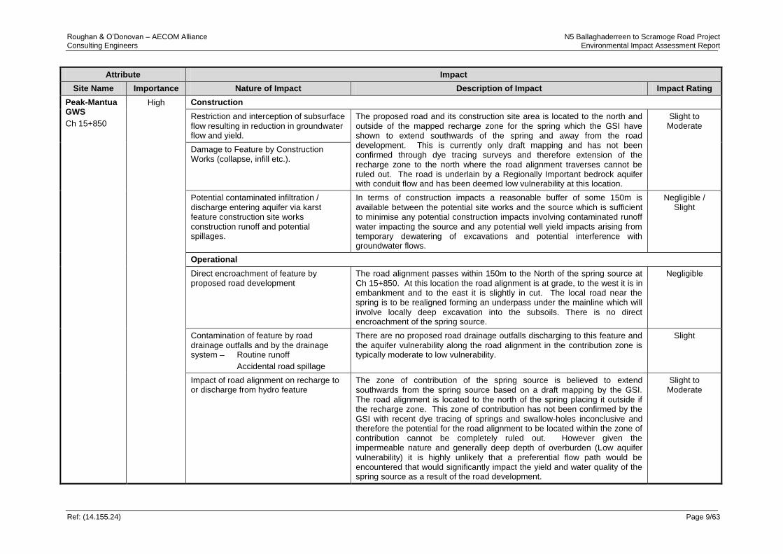
Roughan & O’Donovan – AECOM Alliance N5 Ballaghaderreen to Scramoge Road Project Consulting Engineers Environmental Impact Assessment Report
Ref: (14.155.24) Page 9/63
Attribute Impact
Site Name Importance Nature of Impact Description of Impact Impact Rating
Peak-Mantua GWS
Ch 15+850
High Construction
Restriction and interception of subsurface flow resulting in reduction in groundwater flow and yield.
The proposed road and its construction site area is located to the north and outside of the mapped recharge zone for the spring which the GSI have shown to extend southwards of the spring and away from the road development. This is currently only draft mapping and has not been confirmed through dye tracing surveys and therefore extension of the recharge zone to the north where the road alignment traverses cannot be ruled out. The road is underlain by a Regionally Important bedrock aquifer with conduit flow and has been deemed low vulnerability at this location.
Slight to Moderate
Damage to Feature by Construction Works (collapse, infill etc.).
Potential contaminated infiltration / discharge entering aquifer via karst feature construction site works construction runoff and potential spillages.
In terms of construction impacts a reasonable buffer of some 150m is available between the potential site works and the source which is sufficient to minimise any potential construction impacts involving contaminated runoff water impacting the source and any potential well yield impacts arising from temporary dewatering of excavations and potential interference with groundwater flows.
Negligible / Slight
Operational
Direct encroachment of feature by proposed road development
The road alignment passes within 150m to the North of the spring source at Ch 15+850. At this location the road alignment is at grade, to the west it is in embankment and to the east it is slightly in cut. The local road near the spring is to be realigned forming an underpass under the mainline which will involve locally deep excavation into the subsoils. There is no direct encroachment of the spring source.
Negligible
Contamination of feature by road drainage outfalls and by the drainage system – Routine runoff
Accidental road spillage
There are no proposed road drainage outfalls discharging to this feature and the aquifer vulnerability along the road alignment in the contribution zone is typically moderate to low vulnerability.
Slight
Impact of road alignment on recharge to or discharge from hydro feature
The zone of contribution of the spring source is believed to extend southwards from the spring source based on a draft mapping by the GSI. The road alignment is located to the north of the spring placing it outside if the recharge zone. This zone of contribution has not been confirmed by the GSI with recent dye tracing of springs and swallow-holes inconclusive and therefore the potential for the road alignment to be located within the zone of contribution cannot be completely ruled out. However given the impermeable nature and generally deep depth of overburden (Low aquifer vulnerability) it is highly unlikely that a preferential flow path would be encountered that would significantly impact the yield and water quality of the spring source as a result of the road development.
Slight to Moderate
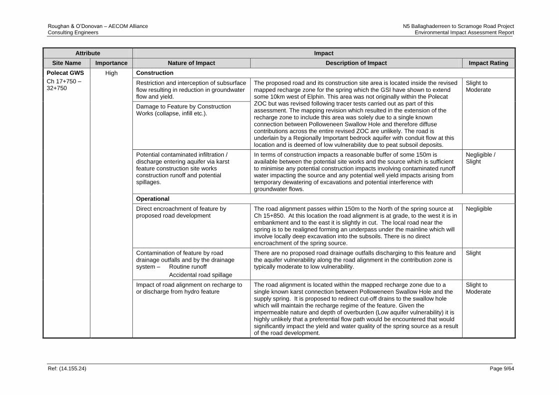
Roughan & O’Donovan – AECOM Alliance N5 Ballaghaderreen to Scramoge Road Project Consulting Engineers Environmental Impact Assessment Report
Ref: (14.155.24) Page 9/64
Attribute Impact
Site Name Importance Nature of Impact Description of Impact Impact Rating
Polecat GWS
Ch 17+750 – 32+750
High Construction
Restriction and interception of subsurface flow resulting in reduction in groundwater flow and yield.
The proposed road and its construction site area is located inside the revised mapped recharge zone for the spring which the GSI have shown to extend some 10km west of Elphin. This area was not originally within the Polecat ZOC but was revised following tracer tests carried out as part of this assessment. The mapping revision which resulted in the extension of the recharge zone to include this area was solely due to a single known connection between Polloweneen Swallow Hole and therefore diffuse contributions across the entire revised ZOC are unlikely. The road is underlain by a Regionally Important bedrock aquifer with conduit flow at this location and is deemed of low vulnerability due to peat subsoil deposits.
Slight to Moderate
Damage to Feature by Construction Works (collapse, infill etc.).
Potential contaminated infiltration / discharge entering aquifer via karst feature construction site works construction runoff and potential spillages.
In terms of construction impacts a reasonable buffer of some 150m is available between the potential site works and the source which is sufficient to minimise any potential construction impacts involving contaminated runoff water impacting the source and any potential well yield impacts arising from temporary dewatering of excavations and potential interference with groundwater flows.
Negligible / Slight
Operational
Direct encroachment of feature by proposed road development
The road alignment passes within 150m to the North of the spring source at Ch 15+850. At this location the road alignment is at grade, to the west it is in embankment and to the east it is slightly in cut. The local road near the spring is to be realigned forming an underpass under the mainline which will involve locally deep excavation into the subsoils. There is no direct encroachment of the spring source.
Negligible
Contamination of feature by road drainage outfalls and by the drainage system – Routine runoff
Accidental road spillage
There are no proposed road drainage outfalls discharging to this feature and the aquifer vulnerability along the road alignment in the contribution zone is typically moderate to low vulnerability.
Slight
Impact of road alignment on recharge to or discharge from hydro feature
The road alignment is located within the mapped recharge zone due to a single known karst connection between Polloweneen Swallow Hole and the supply spring. It is proposed to redirect cut-off drains to the swallow hole which will maintain the recharge regime of the feature. Given the impermeable nature and depth of overburden (Low aquifer vulnerability) it is highly unlikely that a preferential flow path would be encountered that would significantly impact the yield and water quality of the spring source as a result of the road development.
Slight to Moderate

Roughan & O’Donovan – AECOM Alliance N5 Ballaghaderreen to Scramoge Road Project Consulting Engineers Environmental Impact Assessment Report
Ref: (14.155.24) Page 9/65
Attribute Impact
Site Name Importance Nature of Impact Description of Impact Impact Rating
Kilvoy and Corry East
swallow hole and karst features
Ch 18+400 to 19+300
Locally High Construction
Restriction and interception of subsurface flow resulting in reduction in groundwater flow and yield.
This section of the road alignment has a number of karst swallow-hole features running near and in close proximity to the road alignment. The bedrock in this area appears given the density of such features to be soluble and highly karstified. The largest feature, Polloweneen swallow-hole, is a sink to a small local stream. The proposed road passes to the south 25m upstream of this feature. Other swallow hole features are located in proximity to the proposed road footprint which drain local overland flow one of which is lost completely at Ch.19+050.
Moderate
Damage to Feature by Construction Works (collapse, infill etc.).
The geotechnical investigations show considerable weathered bedrock zones along the proposed road development at this location. There is a potential for damage and collapse of these features that could give rise to potential flooding issues and to sink holes.
Slight/ Moderate
Potential contaminated infiltration / discharge entering aquifer via karst feature construction site works construction runoff and potential spillages.
The construction activity will be reasonably proximate to these features which increases the risk for damage through infill, collapse and groundwater pollution from uncontrolled construction site runoff during construction activities. These swallow-holes represent point sources of pollution to the regionally important karst bedrock aquifer. Potential damage to the Polloweneen swallow hole could give rise to flooding as the feature drains a moderate size stream.
Moderate
Operational
Direct encroachment of feature by road alignment
Local cut off drains from the north side of the road alignment will discharge to the Polloweneen swallow-hole feature. This swallow-hole feature shows evidence of surcharging at the feature during flood conditions. This represents a flood risk to the Road further to the east with a potential for flood waters to infiltrate and migrate in the formation layer eastwards to lower road levels. A drainage solution to mitigate this flood risk is required.
Moderate/ Significant
Contamination of feature by road drainage outfalls and by the drainage system – Routine Runoff
Accidental Spillage
There are no proposed road drainage outfalls discharging to these swallow hole features with the road pavement drainage being collected and conveyed in a sealed system eastward to outfall to a surface stream at Ch 21+150.
Slight
Impact of road alignment on recharge to or discharge from hydro feature
The karstification at this location poses a threat to the road stability as it represents a risk of potential collapse from the development of sink-holes. As part of the design for identified karst zones beneath or close to the road development basal reinforcement will be required combined with a drainage layer to maintain existing drainage patterns.
Moderate

Roughan & O’Donovan – AECOM Alliance N5 Ballaghaderreen to Scramoge Road Project Consulting Engineers Environmental Impact Assessment Report
Ref: (14.155.24) Page 9/66
Attribute Impact
Site Name Importance Nature of Impact Description of Impact Impact Rating
Tullyloyd (Ovaun Stream)
Swallow hole feature
Ch 34+400
Locally High Construction
Restriction and interception of subsurface flow resulting in reduction in groundwater flow and yield.
This feature is located adjacent to a maintained arterial drainage channel that outfalls into the Clooncullaan Lough. The swallow hole feature has a spur channel that is connected to the Ovaun Stream. Site visits throughout the year have shown that flow in the Ovaun Stream outfalls both to Clooncullaan Lough and the swallow-hole feature with the proportionality varying significantly over the summer/winter season with water levels in the lake dictating flow conditions.
Negligible / Slight
Damage to Feature by Construction Works (collapse, infill etc.).
This feature is located 150m down gradient of the road alignment which is at grade and in embankment to the east of this feature.
Slight
Potential contaminated infiltration / discharge entering aquifer via karst feature construction site works construction runoff and potential spillages.
The construction activity will be reasonably proximate to this feature which increases the risk for damage from potential uncontrolled site runoff resulting in potential deposition of sediment in the bed of this feature and potential contamination (sediment laden runoff, water quality and construction spillages) of the connected groundwater aquifer. This swallow-holes represent a point sources of pollution to the Regionally important karst bedrock aquifer and may potentially be connected to springs further to the east, however dye tracer studies undertaken as part of this assessment showed this features is not connected to the Polecat Springs GWS.
Moderate
Operational
Direct encroachment of feature by road alignment.
The proposed road alignment is located at grade and on embankment over 150m upgradient of the feature and therefore no direct encroachment of the feature will occur. This distance and proposed road vertical alignment provide ample buffer distance to minimise any potential for direct impact in respect to flow capacity.
Negligible / Slight
Contamination of feature by road drainage outfalls and by the drainage system – Routine Runoff
Accidental Spillage
There are no proposed road drainage outfalls discharging directly to this swallow-hole feature however the proposed road drainage will discharge to a small tributary drain that connects to the Ovaun Stream approximately 400m upstream of this feature. Dye tracing results show that a proportion of the Ovaun Stream Flow discharges to this feature with the remainder of flow discharging westwards to the Clooncullaan Lough. The proportional split varies considerably depending on seasonality. There is a potential for point source contamination of the regionally important karst aquifer system from the road drainage discharge via this feature both routine road drainage and potential road accident spillages.
Moderate
Impact of road alignment on recharge to or discharge from hydro feature
The impact of the road drainage discharge on this feature in respect to flooding is shown to be negligible in respect to increased flood levels at this feature as result of the road drainage discharge to the Ovaun Stream.
Slight

Roughan & O’Donovan – AECOM Alliance N5 Ballaghaderreen to Scramoge Road Project Consulting Engineers Environmental Impact Assessment Report
Ref: (14.155.24) Page 9/67
Attribute Impact
Site Name Importance Nature of Impact Description of Impact Impact Rating
Cregga Turlough
Ch 36+650 to
Ch 37+950
Locally High Construction
Silts and sediments arising from construction works from the large road cutting (excavation, blasting etc.)
The proposed construction works involve significant deep bedrock cutting into the steep hill slopes above the Cregga Turlough Area. Given the terrain and the large excavation works involved, there is a high potential for sediment runoff or spillages from the works to enter the Turlough area which in the short term could impact the water chemistry of the Turlough and result in silt deposition within the Turlough area.
Slight to Moderate
Spillages (hydrocarbons, cement etc.) Spillages occurring during the works could potentially flow or percolate into the subsurface water flow and potentially enter Cregga Turlough polluting surface and groundwater.
Moderate
Disturbance due to construction machinery and carrying out of temporary Works (cofferdams culverts channel diversions, sediment ponds, silt fences etc.).
The proposed road development does not encroach the Turlough extents (as defined by Roger Goodwillie & Associates – see Appendix 7.3) but will intercept its natural recharge waters via overland flow, interflow and deeper percolating flow which temporarily could impact the water balance of the Turlough
Moderate to Significant
Operational
Road drainage and outfalls impacting on water Quality - Routine road runoff
Accidental fuel spills
The road drainage will be a sealed system and will not discharge to the Cregga Turlough. This avoids potential water quality impacts from the routine road runoff waters and accidental road spillages.
Negligible
Road drainage system – Outfalls, Culverts, interceptor drains, diversions and truncations affecting the water flow regime.
A loss of recharge water arising from direct rainfall on the road pavement area which will be piped to an outfall that discharges to the Ovaun Stream.
Moderate to Significant
Interception of drainage paths by the permeable Road formation resulting in diversion of waters and in a dewatering effect on adjacent soils and wetland areas.
The deep cutting will intercept hill slope runoff, interflow and groundwater recharge and flow which will impact potentially on the flow regime, the water balance and the water chemistry of the Turlough. Such an impact is considered to represent a potential significant impact to the hydrological function of the Turlough Habitat.
Significant
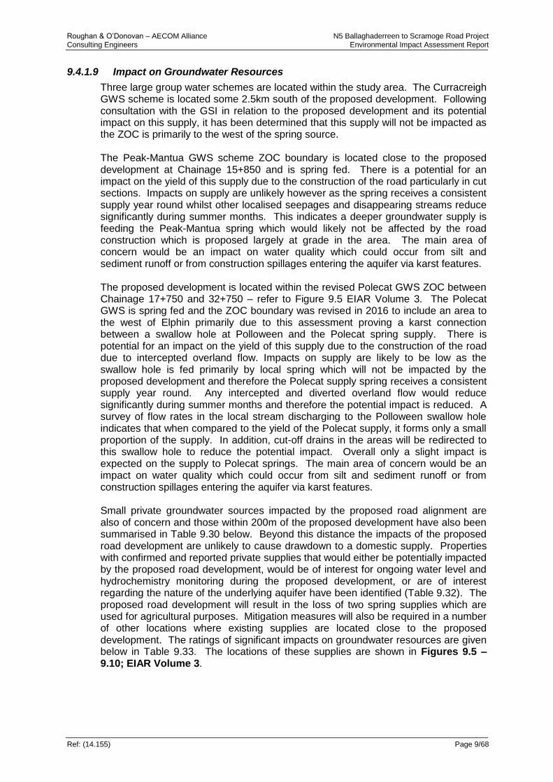
Roughan & O’Donovan – AECOM Alliance N5 Ballaghaderreen to Scramoge Road Project Consulting Engineers Environmental Impact Assessment Report
Ref: (14.155) Page 9/68
9.4.1.9 Impact on Groundwater Resources
Three large group water schemes are located within the study area. The Curracreigh GWS scheme is located some 2.5km south of the proposed development. Following consultation with the GSI in relation to the proposed development and its potential impact on this supply, it has been determined that this supply will not be impacted as the ZOC is primarily to the west of the spring source. The Peak-Mantua GWS scheme ZOC boundary is located close to the proposed development at Chainage 15+850 and is spring fed. There is a potential for an impact on the yield of this supply due to the construction of the road particularly in cut sections. Impacts on supply are unlikely however as the spring receives a consistent supply year round whilst other localised seepages and disappearing streams reduce significantly during summer months. This indicates a deeper groundwater supply is feeding the Peak-Mantua spring which would likely not be affected by the road construction which is proposed largely at grade in the area. The main area of concern would be an impact on water quality which could occur from silt and sediment runoff or from construction spillages entering the aquifer via karst features. The proposed development is located within the revised Polecat GWS ZOC between Chainage 17+750 and 32+750 – refer to Figure 9.5 EIAR Volume 3. The Polecat GWS is spring fed and the ZOC boundary was revised in 2016 to include an area to the west of Elphin primarily due to this assessment proving a karst connection between a swallow hole at Polloween and the Polecat spring supply. There is potential for an impact on the yield of this supply due to the construction of the road due to intercepted overland flow. Impacts on supply are likely to be low as the swallow hole is fed primarily by local spring which will not be impacted by the proposed development and therefore the Polecat supply spring receives a consistent supply year round. Any intercepted and diverted overland flow would reduce significantly during summer months and therefore the potential impact is reduced. A survey of flow rates in the local stream discharging to the Polloween swallow hole indicates that when compared to the yield of the Polecat supply, it forms only a small proportion of the supply. In addition, cut-off drains in the areas will be redirected to this swallow hole to reduce the potential impact. Overall only a slight impact is expected on the supply to Polecat springs. The main area of concern would be an impact on water quality which could occur from silt and sediment runoff or from construction spillages entering the aquifer via karst features. Small private groundwater sources impacted by the proposed road alignment are also of concern and those within 200m of the proposed development have also been summarised in Table 9.30 below. Beyond this distance the impacts of the proposed road development are unlikely to cause drawdown to a domestic supply. Properties with confirmed and reported private supplies that would either be potentially impacted by the proposed road development, would be of interest for ongoing water level and hydrochemistry monitoring during the proposed development, or are of interest regarding the nature of the underlying aquifer have been identified (Table 9.32). The proposed road development will result in the loss of two spring supplies which are used for agricultural purposes. Mitigation measures will also be required in a number of other locations where existing supplies are located close to the proposed development. The ratings of significant impacts on groundwater resources are given below in Table 9.33. The locations of these supplies are shown in Figures 9.5 – 9.10; EIAR Volume 3.

Roughan & O’Donovan – AECOM Alliance N5 Ballaghaderreen to Scramoge Road Project Consulting Engineers Environmental Impact Assessment Report
Ref: (14.155) Page 9/69
Table 9.33: Rating of Significant Environmental Impacts on Groundwater Resources (Refer to Figures 9.5 – 9.10, EIAR Volume 3 for Locations)
Attribute Impact
Site Name Importance Nature of impact Description of Impact Impact Rating
Peak-Mantua GWS Ch.15+800
High Reduction in yield of water supply for GWS domestic usage.
The proposed road development is at grade in the vicinity of this supply however changes in the hydrogeological regime in the area may impact the yield in the spring supply. This is mainly related to deep cutting which have the potential to draw down groundwater levels locally. In addition overland flow which enters the aquifer through karst features may be redirected as part of the works impacting on the supply.
Moderate
Contamination of water supply from road drainage entering aquifer via karst features.
The proposed road development is at grade in the vicinity of this supply however the development is located close to the ZOC and a number of karst features are located within a 3-4km radius. If these karst features are connected to the supply there is a potential for silt laden or contaminated road drainage to enter and contaminate the supply.
Significant
Polecat GWS
Ch.17+750 - 32+750
High Reduction in yield of water supply for GWS domestic usage.
The proposed road development is within the GWS ZOC, however this is mainly due to the karst connection between Polloween swallow hole and the supply springs. A potential impact would therefore relate to changes in the hydrogeological regime in the area which may impact the yield in the spring supply. This is related locally to a potential reduction in overland flow entering the Polloween swallow hole.
Moderate
Contamination of water supply from road drainage entering aquifer via karst features.
The proposed road development is at grade in the vicinity of the Polloween swallow hole, however the development is located close to the karst feature with a number of other karst features located within a 3-4km radius. If these karst features are connected to the supply there is a potential for silt laden or contaminated road drainage to enter and contaminate the supply.
Significant
Curracreigh GWS
High Reduction in yield of water supply for GWS domestic usage.
The proposed road development is located outside the ZOC for this supply. Tracer studies undertaken have shown the supply receives recharge from the south and the road is located to the north. There are no significant cuttings or otherwise which could potentially impact this supply.
Imperceptible

Roughan & O’Donovan – AECOM Alliance N5 Ballaghaderreen to Scramoge Road Project Consulting Engineers Environmental Impact Assessment Report
Ref: (14.155) Page 9/70
Attribute Impact
Site Name Importance Nature of impact Description of Impact Impact Rating
Contamination of water supply from road drainage entering aquifer via karst features.
No karst features noted in the area which could be connected to this supply.
Imperceptible
Domestic well supply used for private supply to commercial premises
Medium Loss of water supply for domestic usage
Located at Ch. 1+850 and c.85m from the mainline. Drawdown unlikely.
Slight/ Moderate
Contamination of water supply from road drainage entering aquifer via karst features
No karst features noted in the area. Negligible
Spring used for agricultural supply
Medium Loss of water supply for domestic usage
Located at Ch. 1+850. Road development will result in the loss of this supply
Significant
Contamination of water supply from road drainage entering aquifer via karst features
N/A N/A
Domestic Well supply
Medium Loss of water supply for domestic usage
Located at 13+550 and some 155m away from the mainline. This well is reported to be to a depth of 61m. The road is in cut of c.10.9m in the area. Drawdown unlikely at this distance.
Slight
Contamination of water supply from road drainage entering aquifer via karst features
Well is located c.155m away from mainline.
Negligible
Domestic Well supply
Medium Loss of water supply for domestic usage
Located at 13+550 and some 188m away from the mainline. This well is reported to be to a depth of 61m. The road is in cut of c.10.9m in the area. Drawdown unlikely at this distance.
Slight
Contamination of water supply from road drainage entering aquifer via karst features
Well is located c.188m away from mainline.
Negligible
Domestic Well supply
Medium Loss of water supply for domestic usage
Located at Ch.13+650 and c.50m away from the mainline. Supply depth reported to be 31m. The road is in cut of c.6.3m. Slight drawdown may occur.
Moderate
Contamination of water supply from road drainage entering aquifer via karst features
No karst features noted in the area. Slight.
Agricultural Well supply
Medium Loss of water supply for domestic usage
Located at Ch. 30+350 and c.80m away from the mainline. Road is in cut of 4.6m. Drawdown unlikely.
Slight/ Moderate
Contamination of water supply from road drainage entering aquifer via karst features
Supply unlikely to be connected to karst features located at Tullyloyd.
Negligible
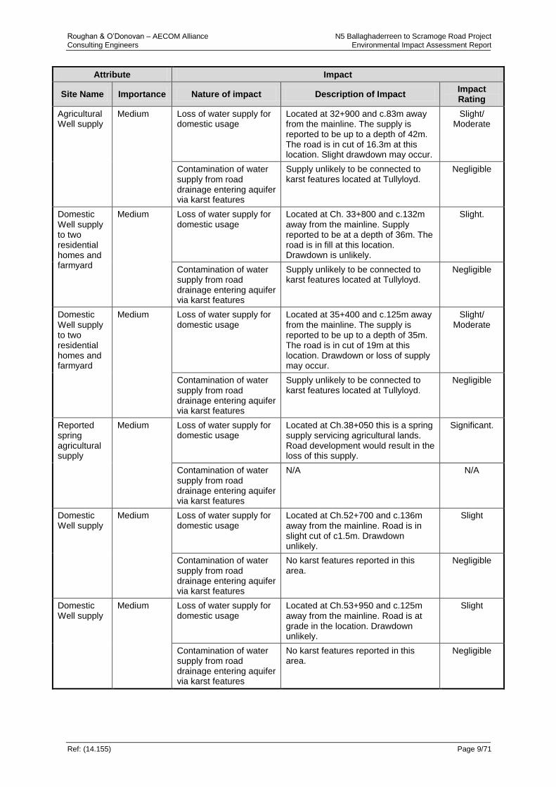
Roughan & O’Donovan – AECOM Alliance N5 Ballaghaderreen to Scramoge Road Project Consulting Engineers Environmental Impact Assessment Report
Ref: (14.155) Page 9/71
Attribute Impact
Site Name Importance Nature of impact Description of Impact Impact Rating
Agricultural Well supply
Medium Loss of water supply for domestic usage
Located at 32+900 and c.83m away from the mainline. The supply is reported to be up to a depth of 42m. The road is in cut of 16.3m at this location. Slight drawdown may occur.
Slight/ Moderate
Contamination of water supply from road drainage entering aquifer via karst features
Supply unlikely to be connected to karst features located at Tullyloyd.
Negligible
Domestic Well supply to two residential homes and farmyard
Medium Loss of water supply for domestic usage
Located at Ch. 33+800 and c.132m away from the mainline. Supply reported to be at a depth of 36m. The road is in fill at this location. Drawdown is unlikely.
Slight.
Contamination of water supply from road drainage entering aquifer via karst features
Supply unlikely to be connected to karst features located at Tullyloyd.
Negligible
Domestic Well supply to two residential homes and farmyard
Medium Loss of water supply for domestic usage
Located at 35+400 and c.125m away from the mainline. The supply is reported to be up to a depth of 35m. The road is in cut of 19m at this location. Drawdown or loss of supply may occur.
Slight/ Moderate
Contamination of water supply from road drainage entering aquifer via karst features
Supply unlikely to be connected to karst features located at Tullyloyd.
Negligible
Reported spring agricultural supply
Medium Loss of water supply for domestic usage
Located at Ch.38+050 this is a spring supply servicing agricultural lands. Road development would result in the loss of this supply.
Significant.
Contamination of water supply from road drainage entering aquifer via karst features
N/A N/A
Domestic Well supply
Medium Loss of water supply for domestic usage
Located at Ch.52+700 and c.136m away from the mainline. Road is in slight cut of c1.5m. Drawdown unlikely.
Slight
Contamination of water supply from road drainage entering aquifer via karst features
No karst features reported in this area.
Negligible
Domestic Well supply
Medium Loss of water supply for domestic usage
Located at Ch.53+950 and c.125m away from the mainline. Road is at grade in the location. Drawdown unlikely.
Slight
Contamination of water supply from road drainage entering aquifer via karst features
No karst features reported in this area.
Negligible
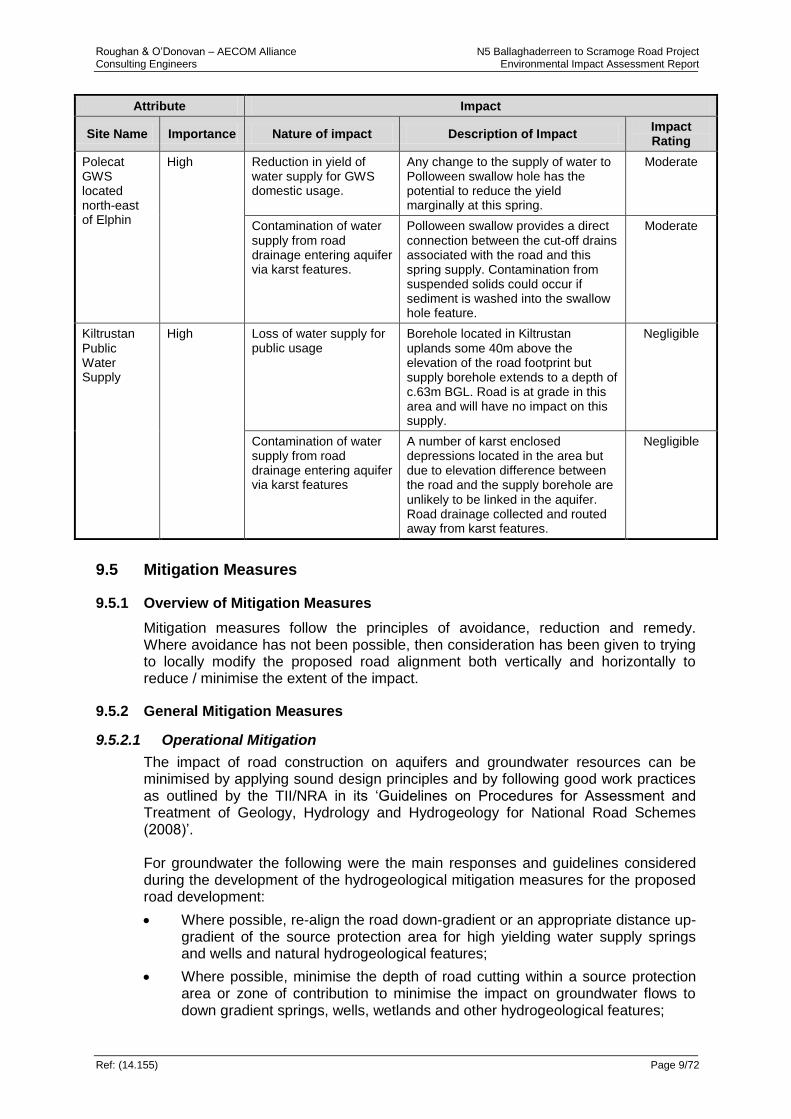
Roughan & O’Donovan – AECOM Alliance N5 Ballaghaderreen to Scramoge Road Project Consulting Engineers Environmental Impact Assessment Report
Ref: (14.155) Page 9/72
Attribute Impact
Site Name Importance Nature of impact Description of Impact Impact Rating
Polecat GWS located north-east of Elphin
High Reduction in yield of water supply for GWS domestic usage.
Any change to the supply of water to Polloween swallow hole has the potential to reduce the yield marginally at this spring.
Moderate
Contamination of water supply from road drainage entering aquifer via karst features.
Polloween swallow provides a direct connection between the cut-off drains associated with the road and this spring supply. Contamination from suspended solids could occur if sediment is washed into the swallow hole feature.
Moderate
Kiltrustan Public Water Supply
High Loss of water supply for public usage
Borehole located in Kiltrustan uplands some 40m above the elevation of the road footprint but supply borehole extends to a depth of c.63m BGL. Road is at grade in this area and will have no impact on this supply.
Negligible
Contamination of water supply from road drainage entering aquifer via karst features
A number of karst enclosed depressions located in the area but due to elevation difference between the road and the supply borehole are unlikely to be linked in the aquifer. Road drainage collected and routed away from karst features.
Negligible
9.5 Mitigation Measures
9.5.1 Overview of Mitigation Measures
Mitigation measures follow the principles of avoidance, reduction and remedy. Where avoidance has not been possible, then consideration has been given to trying to locally modify the proposed road alignment both vertically and horizontally to reduce / minimise the extent of the impact.
9.5.2 General Mitigation Measures
9.5.2.1 Operational Mitigation
The impact of road construction on aquifers and groundwater resources can be minimised by applying sound design principles and by following good work practices as outlined by the TII/NRA in its ‘Guidelines on Procedures for Assessment and Treatment of Geology, Hydrology and Hydrogeology for National Road Schemes (2008)’. For groundwater the following were the main responses and guidelines considered during the development of the hydrogeological mitigation measures for the proposed road development:
Where possible, re-align the road down-gradient or an appropriate distance up-gradient of the source protection area for high yielding water supply springs and wells and natural hydrogeological features;
Where possible, minimise the depth of road cutting within a source protection area or zone of contribution to minimise the impact on groundwater flows to down gradient springs, wells, wetlands and other hydrogeological features;

Roughan & O’Donovan – AECOM Alliance N5 Ballaghaderreen to Scramoge Road Project Consulting Engineers Environmental Impact Assessment Report
Ref: (14.155) Page 9/73
Where possible, minimise the depth of road cutting in order to ensure that its zone of contribution does not extend up gradient to a hydrogeological feature or wetland;
Provide sealed drains along sections of road overlying the vulnerable parts of locally important or regionally important aquifers;
Provide site-specific measures to protect relatively small natural hydrogeological features such as springs, seeps or wetlands;
Assess the potential impact of re-grading small streams on nearby wells or springs;
Ensure all surface water run-off discharged to groundwater via soakaways is passed through systems for settlement or filtration of suspended solids with the parallel effect of removing contaminants (certain heavy metals and hydrocarbons) associated with the suspended solids;
Groundwater monitoring may be appropriate in certain instances, instead of automatically providing specific mitigation measures. In these circumstances however, thresholds should be set that will trigger the introduction of pre-defined mitigation measures;
Specifying regular monitoring of groundwater during the construction period and for a defined period thereafter, following opening of the proposed development;
All wells abandoned as part of the road development should be sealed and abandoned in accordance with “Well Drilling Guidelines (2007)” produced by the Institute of Geologists of Ireland (IGI). Ground investigation boreholes should be backfilled using bentonite or cement bentonite grout in accordance with the Specification and Related Documentation for Ground Investigation (2006) published by the Institution of Engineers of Ireland; and
Abandon obsolete ground investigation boreholes / water supply wells and springs in accordance with the appropriate well drilling guidelines.
The above guidelines have been considered during the development of the design such that impacts have been minimised. Site specific mitigation measures for the unavoidable impacts are detailed in Section 9.5.3. In formulating hydrogeological mitigation measures, regard was made to the requirements of the Water Framework Directive (Directive 2000/60/EC of the European Parliament, 2000) and Groundwater Directive (Directive 2006/118/EC of the European Parliament, 2006) and the enabling national legislation. In developing mitigation measures, there was co-ordinated and ongoing consultation with the River Basin Management Projects, the National Parks and Wildlife Service (NPWS), Local Authorities, Group Water Schemes and Environmental Protection Agency (EPA) as required. The following mitigation will be incorporated in respect of groundwater supplies:
All groundwater supplies currently in use that are within the footprint of the proposed road development will be replaced either through the provision of a private supply or by providing a connection to an existing public or group water scheme;
All groundwater supplies currently in use that are up to 150m from the development boundary or 50m beyond the zone of influence of cuttings will be monitored (for water level and quality) immediately prior to the commencement of construction activities, during on a regular basis and for a time (typically

Roughan & O’Donovan – AECOM Alliance N5 Ballaghaderreen to Scramoge Road Project Consulting Engineers Environmental Impact Assessment Report
Ref: (14.155) Page 9/74
monthly for 12 months) after construction. Monitoring of any private supplies is subject to agreement by the relevant land/ property owner. Should it be concluded that any of these monitored private supplies be lost or contaminated as a result of the development, these shall be replaced either through the provision of a private supply or by providing a connection to an existing public or group water scheme.
9.5.2.2 Constructional Mitigation
During the construction phase any compound areas / service yards are to be located away from key hydrogeologically sensitive areas and features (Swallow holes, springs, turloughs, etc.) and these have been set out in the Construction Erosion and Sediment Control Plan (CESCP) in Appendix 10.1. Further details are also set out in Section 9.5.3 below. In terms of avoiding regionally important aquifers, this was not possible as it is the dominant aquifer type along the route and therefore best environmental practises have been set out in the CESCP to protect against potential pollution. To minimise the risk of pollution to the groundwater, any fuel storage, refuelling and maintenance of construction vehicles will be carried out in accordance with the procedure set out in the CESCP in order to manage any spillages. Procedures are set out in Chapter 10 Hydrology and the CESCP (see Appendix 10.1) which will require that any hydrocarbon leakages or spillages during construction will be dealt with immediately. These measures will absorb the bulk of the contaminant immediately with absorbent material, storing it and the contaminated soil in a stockpile underlain and covered by plastic to prevent leachate generation, until such times as it can be removed off-site by an appropriately licensed waste management company. Where significant groundwater flows are encountered in deep bedrock cut sections, mitigation will be provided to ensure the continued flow of same where possible. The mitigation may involve either piping, construction of gravel filled pathways or short diversions such as the potential case at Cregga Turlough which is outlined in Chapter 10. The Contractor shall be made aware of any areas of potential karst features located at shallow depths, and site traffic in these areas kept to a minimum to reduce the potential compression and collapse of subsurface flow features. Imported fill shall be in accordance with the requirements of the NRA/TII Specification for Road Works. Where water supply wells and springs are located underneath the proposed road development footprint, these will be sealed to prevent contaminants entering the aquifer (Well Drilling Guidelines (IGI, 2007)).
9.5.3 Site Specific Mitigation Required
9.5.3.1 Extreme Vulnerability Areas
Construction
Prior to the commencement of construction works, clean runoff water from lands adjacent to and up gradient of the works area will be diverted to local watercourses through the installation of cut-off ditches. Soiled construction runoff water will undergo treatment before discharge by being passed through a settlement pond (either temporary or permanent pond system). The treated water may be discharged to a surface water body, but depending on drainage features may also discharge to ground (i.e. Mantua, Cregga Turlough) so as to maintain the existing recharge conditions. Further details on the protection of groundwater from pollution during construction are given in the CESCP in Appendix 10.1.

Roughan & O’Donovan – AECOM Alliance N5 Ballaghaderreen to Scramoge Road Project Consulting Engineers Environmental Impact Assessment Report
Ref: (14.155) Page 9/75
Operational
Throughout the proposed road development in areas of extreme and high vulnerability and near sensitive ecological receptors, a sealed drainage system will be used – see Table 9.28 for details. This avoids potential for infiltration to groundwater as a linear source and this approach is in accordance with best practise. However, some watercourses in this karst bedrock area have naturally losing sections of channel which can discharge to groundwater. This has the potential to provide a pathway for road runoff to enter the groundwater system. Wetland systems will be provided at all outfalls to protect both surface and groundwater from any adverse quality and/or quantity impacts of the road drainage discharge.
9.5.3.2 Hydrogeological Features
Each of the hydrogeological features identified that are potentially at risk due to the proposed development were assessed based on the potential magnitude of the impact in Table 9.35. Where an impact rating was deemed to be slight or negligible it is considered that the adherence to good construction practices can adequately mitigate the level of risk involved and no additionally specific mitigation is required. Each of the features which were found to have an impact rating greater than slight have been considered to require some form of mitigation to reduce the magnitude of the risk posed. Table 9.35 gives details of the specific mitigation measures proposed at each hydrogeological feature. These mitigation measures are further detailed below. Wetland and Ecologically Sensitive Areas – General Mitigation Measures
Construction
The adherence to best practise construction methods shall ensure that dewatering does not occur to these sensitive areas. In addition the practices set out in the CESCP will ensure that soiled constructional runoff waters do not enter these areas. Operational
All wetland and ecologically sensitive features (i.e. Tullyloyd Fen) that are traversed or are in close proximity to the proposed road development will incorporate sealed drainage systems to minimise or reduce the potential for contamination – see Table 9.28 for details. The use of over the edge embankment drainage and toe drains shall not be permitted in these sensitive areas as they have the potential to either drain or introduce additional surface and groundwater flows to these features. The use of french drains to convey road runoff is not to be permitted in these areas as they provide a potential pathway for road runoff contaminants to enter the bedrock aquifer. Refer to Chapter 10 – Hydrology for further details of the drainage systems proposed along the proposed development. Deep Cut Sections
Construction
At deep cut sections such as Killeen East (32+100 to 33+100) and Cregga Hill (35+600 to 37+600) the adherence to best practise construction methods shall ensure that the correct management of surface water runoff occurs. Detailed construction mitigation measures are proposed to ensure overland and interflow are kept separate and no pollution occurs in the Turlough and associated groundwater body – refer to Appendix 10.1 for details.
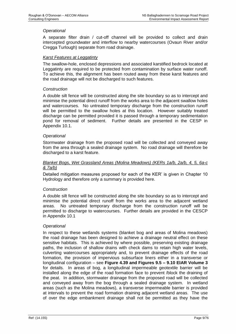
Roughan & O’Donovan – AECOM Alliance N5 Ballaghaderreen to Scramoge Road Project Consulting Engineers Environmental Impact Assessment Report
Ref: (14.155) Page 9/76
Operational
A separate filter drain / cut-off channel will be provided to collect and drain intercepted groundwater and interflow to nearby watercourses (Ovaun River and/or Cregga Turlough) separate from road drainage. Karst Features at Leggatinty
The swallow-hole, enclosed depressions and associated karstified bedrock located at Leggatinty are required to be protected from contamination by surface water runoff. To achieve this, the alignment has been routed away from these karst features and the road drainage will not be discharged to such features. Construction
A double silt fence will be constructed along the site boundary so as to intercept and minimise the potential direct runoff from the works area to the adjacent swallow holes and watercourses. No untreated temporary discharge from the construction runoff will be permitted to the swallow holes at this location. However suitably treated discharge can be permitted provided it is passed through a temporary sedimentation pond for removal of sediment. Further details are presented in the CESP in Appendix 10.1. Operational
Stormwater drainage from the proposed road will be collected and conveyed away from the area through a sealed drainage system. No road drainage will therefore be discharged to a karst feature. Blanket Bogs, Wet Grassland Areas (Molina Meadows) (KERs 1a/b, 2a/b, 4, 5, 6a-c & 7a/b)
Detailed mitigation measures proposed for each of the KER’ is given in Chapter 10 Hydrology and therefore only a summary is provided here. Construction
A double silt fence will be constructed along the site boundary so as to intercept and minimise the potential direct runoff from the works area to the adjacent wetland areas. No untreated temporary discharge from the construction runoff will be permitted to discharge to watercourses. Further details are provided in the CESCP in Appendix 10.1 Operational
In respect to these wetlands systems (blanket bog and areas of Molina meadows) the road drainage has been designed to achieve a drainage neutral effect on these sensitive habitats. This is achieved by where possible, preserving existing drainage paths, the inclusion of shallow drains with check dams to retain high water levels, culverting watercourses appropriately and, to prevent drainage effects of the road formation, the provision of impervious subsurface liners either in a transverse or longitudinal configuration – see Figure 4.39 and Figures 9.5 – 9.10 EIAR Volume 3 for details. In areas of bog, a longitudinal impermeable geotextile barrier will be installed along the edge of the road formation face to prevent /block the draining of the peat. In addition, stormwater drainage from the proposed road will be collected and conveyed away from the bog through a sealed drainage system. In wetland areas (such as the Molina meadows), a transverse impermeable barrier is provided at intervals to prevent the road formation draining adjacent wetland areas. The use of over the edge embankment drainage shall not be permitted as they have the
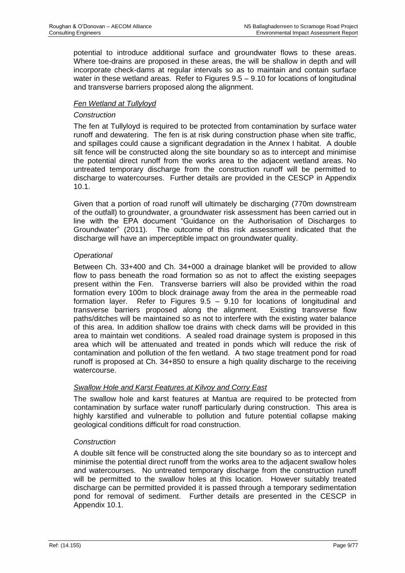
Roughan & O’Donovan – AECOM Alliance N5 Ballaghaderreen to Scramoge Road Project Consulting Engineers Environmental Impact Assessment Report
Ref: (14.155) Page 9/77
potential to introduce additional surface and groundwater flows to these areas. Where toe-drains are proposed in these areas, the will be shallow in depth and will incorporate check-dams at regular intervals so as to maintain and contain surface water in these wetland areas. Refer to Figures 9.5 – 9.10 for locations of longitudinal and transverse barriers proposed along the alignment.
Fen Wetland at Tullyloyd
Construction
The fen at Tullyloyd is required to be protected from contamination by surface water runoff and dewatering. The fen is at risk during construction phase when site traffic, and spillages could cause a significant degradation in the Annex I habitat. A double silt fence will be constructed along the site boundary so as to intercept and minimise the potential direct runoff from the works area to the adjacent wetland areas. No untreated temporary discharge from the construction runoff will be permitted to discharge to watercourses. Further details are provided in the CESCP in Appendix 10.1. Given that a portion of road runoff will ultimately be discharging (770m downstream of the outfall) to groundwater, a groundwater risk assessment has been carried out in line with the EPA document “Guidance on the Authorisation of Discharges to Groundwater” (2011). The outcome of this risk assessment indicated that the discharge will have an imperceptible impact on groundwater quality. Operational
Between Ch. 33+400 and Ch. 34+000 a drainage blanket will be provided to allow flow to pass beneath the road formation so as not to affect the existing seepages present within the Fen. Transverse barriers will also be provided within the road formation every 100m to block drainage away from the area in the permeable road formation layer. Refer to Figures 9.5 – 9.10 for locations of longitudinal and transverse barriers proposed along the alignment. Existing transverse flow paths/ditches will be maintained so as not to interfere with the existing water balance of this area. In addition shallow toe drains with check dams will be provided in this area to maintain wet conditions. A sealed road drainage system is proposed in this area which will be attenuated and treated in ponds which will reduce the risk of contamination and pollution of the fen wetland. A two stage treatment pond for road runoff is proposed at Ch. 34+850 to ensure a high quality discharge to the receiving watercourse. Swallow Hole and Karst Features at Kilvoy and Corry East
The swallow hole and karst features at Mantua are required to be protected from contamination by surface water runoff particularly during construction. This area is highly karstified and vulnerable to pollution and future potential collapse making geological conditions difficult for road construction. Construction
A double silt fence will be constructed along the site boundary so as to intercept and minimise the potential direct runoff from the works area to the adjacent swallow holes and watercourses. No untreated temporary discharge from the construction runoff will be permitted to the swallow holes at this location. However suitably treated discharge can be permitted provided it is passed through a temporary sedimentation pond for removal of sediment. Further details are presented in the CESCP in Appendix 10.1.
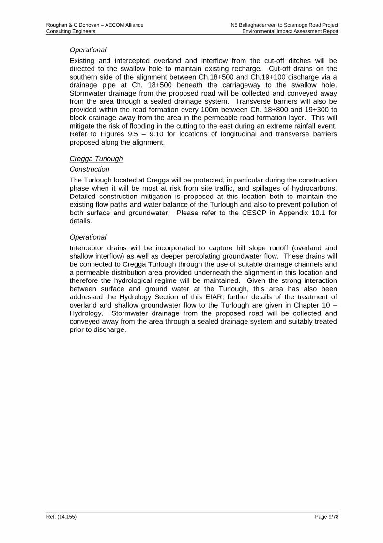
Roughan & O’Donovan – AECOM Alliance N5 Ballaghaderreen to Scramoge Road Project Consulting Engineers Environmental Impact Assessment Report
Ref: (14.155) Page 9/78
Operational
Existing and intercepted overland and interflow from the cut-off ditches will be directed to the swallow hole to maintain existing recharge. Cut-off drains on the southern side of the alignment between Ch.18+500 and Ch.19+100 discharge via a drainage pipe at Ch. 18+500 beneath the carriageway to the swallow hole. Stormwater drainage from the proposed road will be collected and conveyed away from the area through a sealed drainage system. Transverse barriers will also be provided within the road formation every 100m between Ch. 18+800 and 19+300 to block drainage away from the area in the permeable road formation layer. This will mitigate the risk of flooding in the cutting to the east during an extreme rainfall event. Refer to Figures 9.5 – 9.10 for locations of longitudinal and transverse barriers proposed along the alignment. Cregga Turlough
Construction
The Turlough located at Cregga will be protected, in particular during the construction phase when it will be most at risk from site traffic, and spillages of hydrocarbons. Detailed construction mitigation is proposed at this location both to maintain the existing flow paths and water balance of the Turlough and also to prevent pollution of both surface and groundwater. Please refer to the CESCP in Appendix 10.1 for details. Operational
Interceptor drains will be incorporated to capture hill slope runoff (overland and shallow interflow) as well as deeper percolating groundwater flow. These drains will be connected to Cregga Turlough through the use of suitable drainage channels and a permeable distribution area provided underneath the alignment in this location and therefore the hydrological regime will be maintained. Given the strong interaction between surface and ground water at the Turlough, this area has also been addressed the Hydrology Section of this EIAR; further details of the treatment of overland and shallow groundwater flow to the Turlough are given in Chapter 10 – Hydrology. Stormwater drainage from the proposed road will be collected and conveyed away from the area through a sealed drainage system and suitably treated prior to discharge.

Roughan & O’Donovan – AECOM Alliance N5 Ballaghaderreen to Scramoge Road Project Consulting Engineers Environmental Impact Assessment Report
Ref: (14.155) Page 9/79
Table 9.35: Proposed Mitigation Measures For Hydrogeological Features With The Corresponding Residual Impact Rating
Attribute Impact
Site Name Importance Description of Impact Mitigation Measure Residual Impact
Leggatinty
swallow holes, Caves and karst features Ch 10+000 to 14+000
Locally High Construction
Potential contaminated infiltration / discharge entering aquifer via karst feature construction site works construction runoff and potential spillages.
A CESCP has been developed which the contractor must adhere to. This plan will ensure flows to the stream will be maintained through culverting (refer to Chapter 10) temporary works and diversions and that there is no appreciable deterioration in water quality
Slight
Peak-Mantua Spring Supply Ch 15+900
High Construction
Restriction and interception of subsurface flow resulting in reduction in groundwater flow and yield.
The implementation of the CESCP will ensure no construction related impacts to the Peak-Mantua spring supply. This will include silt fences erected on or inside the development boundary which together with the fenceline will restrict construction activity in the vicinity of the zone of contribution and inhibit silt or sediment material from moving southwards into the ZOC and entering the recharge zone. No works will take place outside the land acquisition boundary and therefore works within the ZOC will not be permitted.
Negligible
Damage to Feature by Construction Works (collapse, infill etc.).
Operational
Impact of road alignment on recharge to or discharge from hydro feature
The implementation of the CESCP will be required by the contractor. The design will ensure surface and groundwater flows in the area are maintained largely intact. Streams will be maintained through culverting (Refer to Chapter 10) and diversions. The road is not in cut at this point and will stay outside the ZOC for the spring supply. This will ensure that there is no appreciable change in recharge/discharge to the spring supply.
Negligible
Polecat Spring
Supply ZOC – (Polloween swallow hole) Ch 17+750 – 32+750
Construction
Restriction and interception of subsurface flow resulting in reduction in groundwater flow and yield.
The implementation of the CESCP will ensure no construction related impacts to the Polloween swallow hole (which is connected to the Polecat spring supply). This will include silt fences which will restrict construction activity in the vicinity of the zone of contribution. In addition, interception ditches (cut-off ditches) will be constructed in advance of the main ground works which will redirect overland flow into the swallow hole and maintain its current recharge regime.
Slight
Damage to Feature by Construction Works (collapse, infill etc.).

Roughan & O’Donovan – AECOM Alliance N5 Ballaghaderreen to Scramoge Road Project Consulting Engineers Environmental Impact Assessment Report
Ref: (14.155) Page 9/80
Attribute Impact
Site Name Importance Description of Impact Mitigation Measure Residual Impact
Polecat Spring Supply ZOC – (Polloween swallow hole) Ch 17+750 – 32+750
Operational
Impact of road alignment on recharge to or discharge from hydro feature
The implementation of the CESCP and EOP will be required by the contractor. The design will ensure surface and groundwater flows in the area are maintained largely intact. Interception ditches will be constructed in advance of the main ground works which will redirect overland flow into the swallow hole and maintain its current recharge regime. This will ensure that there is no appreciable change in recharge/discharge to the spring supply.
Slight
Kilvoy and Corry East swallow hole and karst features
Ch 18+400 to 19+300
Locally High Construction
Restriction and interception of subsurface flow resulting in reduction in groundwater flow and yield.
The proposed road development has been routed away from these karst features, however stormwater drainage, which would have previously entered the area as overland flow, will be collected and conveyed away from karst areas. The CESCP and the measures outlined in Chapter 10 for overland and stream flow diversions will ensure that any reductions in flow to the feature are not appreciable.
Slight
Damage to Feature by Construction Works (collapse, infill etc.).
A CESCP has been developed and will be implemented by the contractor. These features will be fenced off with a double silt fence. This will ensure that damage and collapse of these features does not occur as heavy machinery will not be allowed to work in close proximity.
Slight
Potential contaminated infiltration / discharge entering aquifer via karst feature construction site works construction runoff and potential spillages.
Operational
Flood risk to the road from surcharging of the swallow hole feature.
Cut-off drains from the north and south of the alignment will be directed to a drainage pipe at Ch.18+500 which will discharge to the swallow hole. In addition two transverse barriers will be incorporated beneath the road to the east to mitigate the flood risk to the road at the base of the cutting.
Slight
Failure of the road due to the collapse of karst features beneath the road footprint.
Basal reinforcement (Ch. 18+450 – Ch. 19+300 & Ch. 20+350 – Ch. 20+550 combined with a drainage layer (Ch 18+400 – Ch. 19+300m) to maintain existing drainage patterns has been incorporated into the road construction design at this location.
Slight

Roughan & O’Donovan – AECOM Alliance N5 Ballaghaderreen to Scramoge Road Project Consulting Engineers Environmental Impact Assessment Report
Ref: (14.155) Page 9/81
Attribute Impact
Site Name Importance Description of Impact Mitigation Measure Residual Impact
Ovaun Stream Swallow hole feature
Ch 34+400
Locally High Construction
Damage to Feature by Construction Works (collapse, infill etc.).
The construction works will not take place within 100m of this feature. The CESCP will ensure that construction works do not impact on this feature.
Slight
Potential contaminated infiltration / discharge entering aquifer via karst feature construction site works construction runoff and potential spillages.
All site drainage is being routed through an attenuation pond which is to be constructed in advance of any works and will provide treatment prior to discharge. In addition the CESCP will ensure that construction works do not impact on this feature.
Slight
Operational
Contamination of feature by road drainage outfalls and by the drainage system – Routine Runoff
Accidental Spillage
An assessment of flows in the Ovaun has shown that only a small proportion enters groundwater through the swallow hole feature. This occurs some 150m downstream of where the road drainage outfall is located. The road drainage is treated to a high standard in an attenuation pond with a treatment forebay and penstock provided prior to this outfall point. Given the low level of contaminants anticipated and the treatment measures involved the risk to groundwater is very low.
Slight
Cregga Turlough
Ch 36+650 to Ch 37+90
Locally High Construction
Silts and sediments arising from construction related activity (excavation, breaking, blasting etc.)
A CESCP has been developed and will be implemented by the contractor. Construction sequencing has been developed to avoid sediment laden waters entering the Turlough. Refer to the CESCP in Appendix 10.1 for full details.
Slight
Spillages (hydrocarbons, cement etc.) into watercourses and onto wetlands.
The measures outlined in the CESCP will ensure contaminated waters do not enter the Turlough.
Slight
Disturbance due to construction machinery and carrying out of temporary Works (cofferdams culverts channel diversions, sediment ponds, silt fences etc.)
Operational
Interception of drainage paths by the permeable road formation resulting in diversion of waters and in a dewatering effect on adjacent soils and wetland areas
All overland flow and flows arising from the rock cut face will be directed into infiltration galleries located between Ch.36+500 to Ch.36+700, Ch.37+670 to Ch.37+870 and Ch.38+030 to 38+130. This will ensure that all natural overland flow to the Turlough will be largely maintained with no appreciable change.
Slight
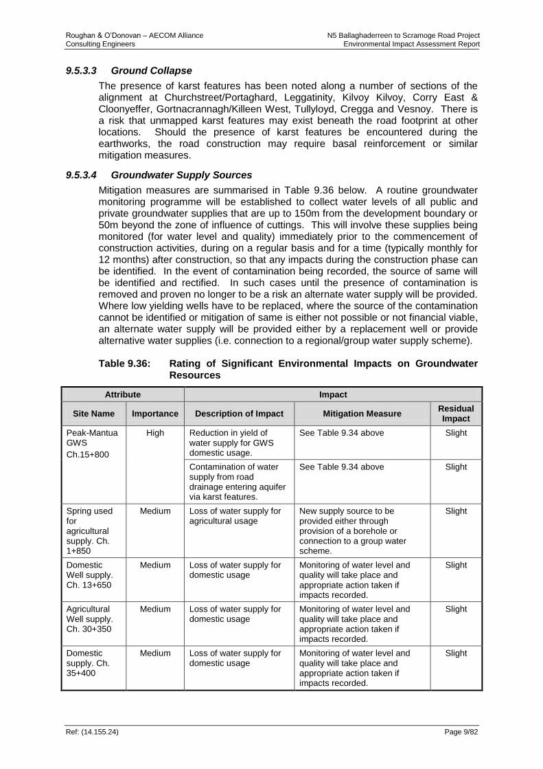
Roughan & O’Donovan – AECOM Alliance N5 Ballaghaderreen to Scramoge Road Project Consulting Engineers Environmental Impact Assessment Report
Ref: (14.155.24) Page 9/82
9.5.3.3 Ground Collapse
The presence of karst features has been noted along a number of sections of the alignment at Churchstreet/Portaghard, Leggatinity, Kilvoy Kilvoy, Corry East & Cloonyeffer, Gortnacrannagh/Killeen West, Tullyloyd, Cregga and Vesnoy. There is a risk that unmapped karst features may exist beneath the road footprint at other locations. Should the presence of karst features be encountered during the earthworks, the road construction may require basal reinforcement or similar mitigation measures.
9.5.3.4 Groundwater Supply Sources
Mitigation measures are summarised in Table 9.36 below. A routine groundwater monitoring programme will be established to collect water levels of all public and private groundwater supplies that are up to 150m from the development boundary or 50m beyond the zone of influence of cuttings. This will involve these supplies being monitored (for water level and quality) immediately prior to the commencement of construction activities, during on a regular basis and for a time (typically monthly for 12 months) after construction, so that any impacts during the construction phase can be identified. In the event of contamination being recorded, the source of same will be identified and rectified. In such cases until the presence of contamination is removed and proven no longer to be a risk an alternate water supply will be provided. Where low yielding wells have to be replaced, where the source of the contamination cannot be identified or mitigation of same is either not possible or not financial viable, an alternate water supply will be provided either by a replacement well or provide alternative water supplies (i.e. connection to a regional/group water supply scheme). Table 9.36: Rating of Significant Environmental Impacts on Groundwater
Resources
Attribute Impact
Site Name Importance Description of Impact Mitigation Measure Residual Impact
Peak-Mantua GWS
Ch.15+800
High Reduction in yield of water supply for GWS domestic usage.
See Table 9.34 above Slight
Contamination of water supply from road drainage entering aquifer via karst features.
See Table 9.34 above Slight
Spring used for agricultural supply. Ch. 1+850
Medium Loss of water supply for agricultural usage
New supply source to be provided either through provision of a borehole or connection to a group water scheme.
Slight
Domestic Well supply. Ch. 13+650
Medium Loss of water supply for domestic usage
Monitoring of water level and quality will take place and appropriate action taken if impacts recorded.
Slight
Agricultural Well supply. Ch. 30+350
Medium Loss of water supply for domestic usage
Monitoring of water level and quality will take place and appropriate action taken if impacts recorded.
Slight
Domestic supply. Ch. 35+400
Medium Loss of water supply for domestic usage
Monitoring of water level and quality will take place and appropriate action taken if impacts recorded.
Slight

Roughan & O’Donovan – AECOM Alliance N5 Ballaghaderreen to Scramoge Road Project Consulting Engineers Environmental Impact Assessment Report
Ref: (14.155.24) Page 9/83
Attribute Impact
Site Name Importance Description of Impact Mitigation Measure Residual Impact
Agricultural Well supply. Ch. 32+900
Medium Loss of water supply for domestic usage
Monitoring of water level and quality will take place and appropriate action taken if impacts recorded.
Slight
Polecat GWS located north-east of Elphin
High Reduction in yield of water supply for GWS domestic usage.
Monitoring of water level and quality will take place and appropriate action taken if impacts recorded – see Table 9.34 for further mitigation measures.
Slight
Contamination of water supply from road drainage entering aquifer via karst features.
The CESCP will be implemented in full which will limit construction sediment entering the swallow hole. In addition monitoring of water level and quality will take place and appropriate action taken if impacts recorded – see Table 9.34 for further mitigation measures.
Slight
Spring agricultural supply. Ch.38+050
Medium Loss of water supply for domestic usage
New supply source to be provided either through provision of a borehole or connection to a group water scheme.
Slight
9.5.3.5 Attenuation Ponds
In order to prevent seepage through the base and sidewalls of attenuation ponds, the main body of the pond will be lined with cohesive material, and additionally with an engineered liner where sealed drainage systems are used, subject to Section 9.4.1.6 and outlet by infiltration will not be permitted. The treatment forebay and main attenuation area will be lined as above and suitably planted to promote the removal of contaminants. A penstock is also provided at the outlet so that in the event of an accidental spillage entering the pond, the outlet can be closed and the contaminant removed by pumping.
9.6 Residual Impacts Residual impacts, remaining after the specific mitigation, have been assessed and are summarised in Table 9.34 and Table 9.35. All other residual impacts have been assessed as slight residual impact.
9.6.1 Road Drainage
There is a potential residual impact on groundwater quality from losing streams which has been assessed as a slight impact. There is also a potential residual impact for sealed drains which are not sealed, however this is considered to be so small that it will have a slight to imperceptible residual impact.
9.6.2 Cut Sections
Any significant cut sections exceeding 3m in depth and associated drainage system along the proposed road alignment would be expected to locally lower the
Roughan & O’Donovan – AECOM Alliance N5 Ballaghaderreen to Scramoge Road Project Consulting Engineers Environmental Impact Assessment Report
Ref: (14.155.24) Page 9/84
groundwater table where intercepted. This represents a localised slight residual impact.
9.6.3 Hydrogeological features
Features such as the Leggatinty and Mantua swallow holes, Leggatinty and Drummin Bogs, Tullyloyd Fen and Cregga Turlough will always be potentially at risk from contaminated surface water runoff entering their hydrogeological regime. The proposed mitigation of sealed drainage systems in these areas mitigate this potential impact reducing it to a slight residual.
9.6.4 Groundwater Resources
Groundwater resources have the potential to be impacted by the proposed development. The quality of groundwater is at risk in high and extreme vulnerability areas and in areas of karst bedrock. A comprehensive suite of mitigation measures are proposed both during the construction and operational phase of the road development which will mitigate these impacts. Any potential impact on quality will be at a very localised scale. Given the mitigation proposed there is a slight residual impact from the proposed development with respect to groundwater quality as a resource. In terms of the quantity of groundwater available within the aquifer (the yield of the resource) there will be an imperceptible effect at the regional scale. There is the potential for residual impacts at the local level where well yields may be impacted or reduced. With the mitigation proposed as part of the development this is assessed as a slight residual impact.