Embed Size (px)
Citation preview

Chapter 8 Nahr El Kabir Basin
How to citeUN-ESCWA and BGR (United Nations Economic and Social Commission for Western Asia; Bundesanstalt für Geowissenschaften und Rohstoffe). 2013. Inventory of Shared Water Resources in Western Asia. Beirut.
INVENTORY OF
SHARED WATER RESOURCES IN WESTERN ASIA (ONLINE VERSION)

246
CHAPTER 8 - NAHR EL KABIR BASIN
EXECUTIVE SUMMARY
The Nahr el Kabir rises from numerous springs in Syria and in the Lebanon Mountain range. It runs a westerly course forming a natural border between northern Lebanon and Syria. The Nahr el Kabir maintains most of its natural seasonal characteristics as water regulation is limited on the main river stem and in the runoff generation area in Lebanon and Syria.
Environmental degradation is a major issue in the basin: the river is severely polluted by widespread discharge of untreated sewage and uncontrolled solid waste disposal. Other threats include recurrent floods and the spread of water hyacinth along the whole river course. The two countries cooperate on the basis of a 2002 water-sharing agreement, with several joint technical sub-committees tackling various issues related to the watershed.
Nahr El Kabir Basin
Overlooking the Bqaiaa Plain near the village of Chadra, Lebanon, 2010. Source: Eileen Maternowski.
KEY CONCERNS
BASIN FACTS MAIN AGREEMENTS
Lebanon, SyriaRIPARIAN COUNTRIES
Lebanon 26%Syria 74%
BASIN AREA SHARES
954 km2BASIN AREA
77.8 kmRIVER LENGTH
377 MCMMEAN ANNUAL FLOW VOLUME
3 (max. storage capacity 75 MCM)
DAMS
~23,000 haPROJECTED IRRIGATED AREA
530,000BASIN POPULATION
2002 – Agreement between Lebanon and Syria to share the water of the Nahr el Kabir and build a joint dam on the main stem.
LEBANON - SYRIA
WATER QUALITY
The Nahr el Kabir is severely polluted. The absence of sound agricultural practices, the uncontrolled discharge of untreated wastewater and the random disposal of solid waste by both riparians has led to widespread environmental degradation and poses a serious threat to public health. Concerns over water quality are not addressed in the Syrian-Lebanese water agreement.

247
INVENTORY OF SHARED WATER RESOURCES IN WESTERN ASIA - PART I
¸
¸
¸¸
¸
µ
µ
µ
µ
µAin
Nassiriyah
AinKhalifah
Akkar/Hamidiyeplain Bqaiaa
plain
Raw
eel
Nassiriya
el Kabir
Es-Safa
Orontes
LakeZeita
Lake Homs
Cha
dra
Abou Foulat
Arous
Khali
fah
Nahr
Mediterranean
Sea
el Kabir
Nahr Nahr el Kabir
Ostuene
Noura al Tahta(planned)
Hekr al Dahri
Beino
Safita
Hermel
Fnaidek
Tell Kalakh
Arida
Aandqet
Idlin
Noura al Tahta
Khalifah
Mzeineh
Tell Hosh
$
$
$
$
AinFarash
AinEs-Safa
Ain Zarqa
ñ
ñ36°20'E
36°20'E
36°E
36°E
34°40'N
S y r i a
L e b a n o n
0 10 205km
Saudi Arabia
Turkey
Iraq
Iran
Azerbaijan
Jordan
Georgia
Syria
Armenia
Kuwait
Lebanon
Nahr el Kabir Basin
Freshwater lake
Canal, irrigation tunnel
Intermittent river, wadi
River
Selected city, town
International boundary
Basin boundary
Dam$
Zone of agricultural development
Monitoring station¸
© UN-ESCWA - BGR Beirut 2013
Inventory of Shared Water Resources in Western AsiaDisclaimerThe boundaries and names shown and the designationsused on this map do not imply official endorsement oracceptance by the United Nations.
Springµ
OVERVIEW MAP

248
CHAPTER 8 - NAHR EL KABIR BASIN
CONTENTS
250GEOGRAPHY250River course
250Climate
251Population
252HYDROLOGICAL CHARACTERISTICS252Annual discharge variability
252Flow regime
253Groundwater
254WATER RESOURCES MANAGEMENT254Development & use: Lebanon
254Development & use: Syria
255Water quality & environmental issues
257AGREEMENTS, COOPERATION & OUTLOOK257Agreements
257Cooperation
258Outlook
259NOTES
260BIBLIOGRAPHY

249
INVENTORY OF SHARED WATER RESOURCES IN WESTERN ASIA - PART I
FIGURES
TABLES
BOXES
250Distribution of the Nahr el Kabir Basin areaFIGURE 1.
250Climate diagram for Tripoli, Lebanon, to the south of the Nahr el Kabir BasinFIGURE 2.
252a) Mean annual discharge, b) specific mean annual discharge and c) discharge anomaly time series of the Nahr el Kabir (1955-2011)FIGURE 3.
253Mean monthly stream-flow and groundwater flow regime of the Nahr el Kabir and the Ain Es-Safa Spring (1955-2011) FIGURE 4.
258Organizational structure and roles of the Nahr el Kabir joint sub-committeesFIGURE 5.
251Mean annual precipitation data from meteorological stations in the basin in Lebanon since 2000TABLE 1.
251Estimated basin populationTABLE 2.
252Summary of annual flow volume statistics for the Nahr el Kabir in Lebanon (1955-2011)TABLE 3.
253Mean flow rate of main springs in the Nahr el Kabir BasinTABLE 4.
254Constructed and planned dams in the Nahr el Kabir Basin in SyriaTABLE 5.
255Mean salinity, nutrients, bacteria and heavy metals in the Nahr el Kabir Basin (2001-2002)TABLE 6.
254The Noura al Tahta DamBOX 1.
257Progress on the Joint Noura al Tahta Dam Project BOX 2.

CHAPTER 8 - NAHR EL KABIR BASIN GEOGRAPHY
250
Geography
Source: Compiled by ESCWA-BGR.
Figure 1. Distribution of the Nahr el Kabir Basin area
Figure 2. Climate diagram for Tripoli, Lebanon, to the south of the Nahr el Kabir Basin
The Nahr el Kabir is a shared river that forms the north-south border between Lebanon and Syria. The basin covers 954 km2, of which 26% lie in Lebanon and 74% lie in Syria (Figure 1). Generally, the basin is divided into four geomorphological zones: the mountain region in the upper catchment shared between Lebanon and Syria, the intra-mountainous cross-border Bqaiaa Plain, the central plateau/gorge area running along the border, and the coastal cross-border Akkar/Hamidiye Plain.1
RIVER COURSE
As a coastal Mediterranean river, the Nahr el Kabir flows from east to west over an approximate distance of 52 km if the Ain Es-Safa Spring is considered the source, or 78 km if the Es-Safa tributary is included (see Overview Map). The river forms the international border between the Akkar region in Lebanon and the Syrian governorate of Tartous over much of its course.2
The river rises from numerous karstic springs and wadis (including the springs Ain Nassiriya, Ain Farash, Ain Es-Safa and Ain Khalifah) in the northern part of the Lebanon Mountain range.3 Upon reaching the intra-mountainous Bqaiaa Plain, the Nahr el Kabir turns westward and traverses a basaltic central plateau where it forms steep gorges. It then meanders through the extensive alluvial flatlands of the coastal Akkar/Hamidiye Plain and discharges into the Mediterranean Sea near the Lebanese town of Arida.
Several tributaries discharge into the Nahr el Kabir on both sides of its course, including the Wadi al Atchane, the Nassiriya (formed by the confluence of the Raweel and the Mzeineh) and the Arous on the Syrian side. On the Lebanese
The Great Southern RiverThe name Nahr el Kabir al Janoubi means Great Southern River. Known as Eleutherus in ancient times, the river is mentioned in the Bible. It is also referred to as Nahr al Kebeer, Nahr el Kebir or simply the Kebir.
Source: Compiled by ESCWA-BGR based on data provided by WorldClim, 2011; Climate Diagrams, 2009; Phytosociological Research Center, 2009.
side, the main tributaries are the Wadi Khaled, Es-Safa and Chadra. The Lebanese mountain Qarnat Araba constitutes the highest point of the catchment with an altitude of 2,215 m asl.4
CLIMATE
The climate in the Nahr el Kabir Basin is characterized by Mediterranean winter precipitation with increasing intensity and quantity from the coastal plain towards the mountainous areas and dry, hot summers.5 The mean annual air temperature measured in Tripoli, Lebanon to the south of the basin is 20°C (Figure 2).
Mean annual precipitation in the whole basin ranged from 600 to 1,000 mm6 from 2001 to 2006 (Table 1).7 It is estimated that 40%-50% of precipitation is lost to evapotranspiration and 30% contributes to river runoff.8 Other sources estimate the mean annual basin precipitation at about 854 mm,9 but observed data suggests a complex spatial pattern of precipitation throughout the basin, most likely caused by the intricate micro-climate10 induced by the Homs Gap.11
710 km2
244 km2
SyriaLebanon
Tripoli, Lebanon (6 m)40 250
WƌĞĐŝƉŝƚĂƟŽŶAir temperature30 200
20 150
10 100
0 50
0ͳϭϬ
ΈȗΉ (mm)
Month:ĂŶ Fe
bMar Apr
May :ƵŶ JulAug
Sep Oct EŽ
ǀDec

251
INVENTORY OF SHARED WATER RESOURCES IN WESTERN ASIA - PART I
Table 1. Mean annual precipitation data from meteorological stations in the basin in Lebanon since 2000
Table 2. Estimated basin population
STATION,ELEVATION(m asl)
PRECIPITATION (mm/yr)
2001 2002 2003 2004 2005 2006 MEANa (2001-2006)
Al Qliaat (5) 907 1,002 896 698 876 879 876 (99)
Al Qubayat (540) 963 775 776 867 1,006 987 895 (105)
Halba (119) 980 767 670 770 605 910 783 (141)
Al Aabde (40) 988 904 961 768 814 768 867 (97)
Al Minia (10) 976 990 889 769 876 755 875 (99)
Sir Edenyeh (915) 1,003 956 894 869 991 934 941 (53)
Source: Compiled by ESCWA-BGR based on data provided by NCRS and UN-ESCWA, 2002.(a) Standard deviations in parentheses.
Bridge over the Nahr el Kabir near Hekr al Dahri, Lebanon, 2010. Source: Andreas Renck.
Source: Compiled by ESCWA-BGR.(a) The population estimate for the area of the basin that lies in Lebanon is based on a 2007 study.(b) The population estimate for the area of the basin that lies in Syria is based on a 2010 estimate and includes populations living in the Syrian governorates of Tartous and Homs.
POPULATION
The basin has an estimated total population of 530,000. Settlements, which range from 200 to 5,500 inhabitants, are made up of mixed urban and rural communities.12 About 19% of the basin population lives in the area of the basin in Lebanon, while about 81% of the basin population lives in Syria.
RIPARIAN COUNTRY COUNTRY POPULATION (MILLIONS)
ESTIMATED POPULATION IN THE BASIN
SOURCE
THOUSANDSAS PERCENTAGE OF
TOTAL BASIN POPULATION
Lebanon 4.5 100 19 Central Administration of Statistics in Lebanon, 2011.a
Syria 20.9 430 81 Central Bureau of Statistics in the Syrian Arab Republic, 2005.b
Total 530
252
CHAPTER 8 - NAHR EL KABIR BASIN HYDROLOGICAL CHARACTERISTICS
Source: Compiled by ESCWA-BGR based on Ministry of Energy and Water in Lebanon, 2011.(a) Coefficient of Variation. For information on definition and calculation of the CV see ‘Overview & Methodology: Surface Water’ chapter.
Source: Compiled by ESCWA-BGR based on data provided by the Ministry of Energy and Water in Lebanon, 2011.
STATION(DRAINAGE AREA, km2)
PERIOD MEAN (MCM)
MINIMUM (MCM)
MAXIMUM (MCM) CVa (-)
Hekr al Dahri(954)
1969-1974, 1999-2011 377 73 1,578 0.91
Arida, Bqaiaa Plain (421)
1955-1974, 1992-2009 180 43 458 0.45
Chadra(..)
1966-1974, 1991-2011 9.3 1.7 23.5 0.61
Table 3. Summary of annual flow volume statistics for the Nahr el Kabir in Lebanon (1955-2011)
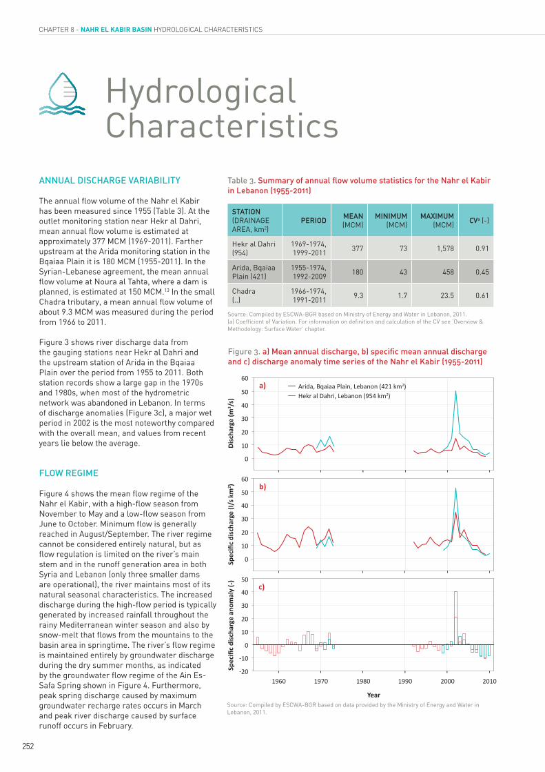
Figure 3. a) Mean annual discharge, b) specific mean annual discharge and c) discharge anomaly time series of the Nahr el Kabir (1955-2011)
Hydrological Characteristics
ANNUAL DISCHARGE VARIABILITY
The annual flow volume of the Nahr el Kabir has been measured since 1955 (Table 3). At the outlet monitoring station near Hekr al Dahri, mean annual flow volume is estimated at approximately 377 MCM (1969-2011). Farther upstream at the Arida monitoring station in the Bqaiaa Plain it is 180 MCM (1955-2011). In the Syrian-Lebanese agreement, the mean annual flow volume at Noura al Tahta, where a dam is planned, is estimated at 150 MCM.13 In the small Chadra tributary, a mean annual flow volume of about 9.3 MCM was measured during the period from 1966 to 2011.
Figure 3 shows river discharge data from the gauging stations near Hekr al Dahri and the upstream station of Arida in the Bqaiaa Plain over the period from 1955 to 2011. Both station records show a large gap in the 1970s and 1980s, when most of the hydrometric network was abandoned in Lebanon. In terms of discharge anomalies (Figure 3c), a major wet period in 2002 is the most noteworthy compared with the overall mean, and values from recent years lie below the average.
FLOW REGIME
Figure 4 shows the mean flow regime of the Nahr el Kabir, with a high-flow season from November to May and a low-flow season from June to October. Minimum flow is generally reached in August/September. The river regime cannot be considered entirely natural, but as flow regulation is limited on the river’s main stem and in the runoff generation area in both Syria and Lebanon (only three smaller dams are operational), the river maintains most of its natural seasonal characteristics. The increased discharge during the high-flow period is typically generated by increased rainfall throughout the rainy Mediterranean winter season and also by snow-melt that flows from the mountains to the basin area in springtime. The river’s flow regime is maintained entirely by groundwater discharge during the dry summer months, as indicated by the groundwater flow regime of the Ain Es-Safa Spring shown in Figure 4. Furthermore, peak spring discharge caused by maximum groundwater recharge rates occurs in March and peak river discharge caused by surface runoff occurs in February.
Disc
harg
e (m
3 /s)
60
60
50
50
40
40
30
30
20
20
50
40
30
20
10
0
ͳϭϬ
1960 1970 1980 1990 2000 2010ͳϮϬ
10
10
0
0
a)
b)
c)
Arida, ƋĂŝĂĂWůĂŝŶ>ĞďĂŶŽŶ;ϰϮϭŬŵ2),ĞŬƌĂůĂŚƌŝ>ĞďĂŶŽŶ;ϵϱϰŬŵ2)
^ƉĞĐŝĮĐĚŝƐĐŚĂ
ƌŐĞ;/
ƐŬŵ
2 )^Ɖ
ĞĐŝĮĐĚŝƐĐŚĂ
ƌŐĞĂŶ
ŽŵĂůLJ;ͲͿ
Year

253
INVENTORY OF SHARED WATER RESOURCES IN WESTERN ASIA - PART I
Source: Compiled by ESCWA-BGR based on data provided by the Ministry of Energy and Water in Lebanon, 2011.
Source: Compiled by ESCWA-BGR based on Central Bureau of Statistics in the Syrian Arab Republic, 2010; Ministry of Energy and Water in Lebanon, 2011.(a) Available flow data for Ain Es-Safa Spring covers the period 1969-2010 and suggests an average flow rate of 1.4 m3/s.
Table 4. Mean flow rate of main springs in the Nahr el Kabir Basin
Figure 4. Mean monthly stream-flow and groundwater flow regime of the Nahr el Kabir and the Ain Es-Safa Spring (1955-2011)
GROUNDWATER
Groundwater significantly contributes to river runoff of the Nahr el Kabir.14 About 70 perennial springs15 ensure that the river’s main channel maintains a continuous flow, even during the dry summer months. The springs’ discharge depends on groundwater recharge from precipitation and snow-melt in the upper catchment zone, which mainly occurs towards the end of the rainy season in winter and spring. The bedrock in the basin is highly fractured and has good aquifer properties.16 The mean annual flow rates of the Ain Farash, Ain Nassiriya, Ain Khalifah and Ain Es-Safa Springs are shown in Table 4. The mean annual flow volume of the Ain Es-Safa Spring for the period of record from 1969 to 2011 is 39.2 MCM.
Geological setting
The aquifers in the Nahr el Kabir Basin were formed through complex tectonic events related to the opening of the Red Sea, and subsequently the Dead Sea. The Yammouneh Fault, which belongs to the Dead Sea Transform Fault (DSTF) System, separates the elevated catchment zones to the east from the Bqaiaa and Akkar/Hamidiye Plains to the west.17
The headwaters of the Lebanese basin area feature a complex sedimentary aquifer system. The central part of the Nahr el Kabir Basin is a gorge carved from a volcanic aquifer system, composed of an upper basalt aquifer that is hydraulically connected to the overlying alluvial sediments, and a lower aquifer separated by a two-metre-thick aquitard clay layer. Finally, an alluvium aquifer system dominates both sides
SPRINGFLOW RATE (m3/s)
2000 2001 2002 2003 2004 2005 2006 2007 2008 2009 AVERAGE(2000-2009)
Ain Farash .. .. 0.58 0.33 0.57 1.33 1.33 .. 0.75 0.75 0.81
Ain Nassiriya .. .. 0.43 0.92 0.81 2.45 2.45 .. 0.69 0.69 1.21
Ain Khalifah .. .. 0.37 0.31 0.36 1.09 0.34 0.64 0.38 0.33 0.48
Ain Es-Safaa 0.71 0.79 1.66 2.62 2.19 2.19 .. .. .. 0.54 1.53
of the basalt flow (i.e. in the coastal Akkar/Hamidiye Plain and the interior Bqaiaa Plain).18
Groundwater recharge areas in the basin are difficult to identify, but empirical observations of different geological settings or subunits indicate their presence. For example, despite the steep slopes in the Chadra area, the Chadra has not shown a significant discharge response to intense rain events. The Chadra sub-basin thus appears to be one of the main regional groundwater19 recharge areas, most likely due to the major fault system.20
,ĞŬƌĂůĂŚƌŝƌŝĚĂƋĂŝĂĂWůĂŝŶŝŶƐͲ^ĂĨĂ^ƉƌŝŶŐ
DĞĂ
ŶŵŽŶ
ƚŚůLJ
ĚŝƐĐŚĂ
ƌŐĞ;ŵ
3 /s)
EŽƌŵŵ
ŽŶƚŚůLJ
ĚŝƐĐŚĂ
ƌŐĞ;ͲͿ
50
40
30
20
10
4
3
2
1
0
0
a)
b)
Month
Sep
EŽǀ
Oct Dec:ĂŶ Fe
bMar Apr
May :ƵŶ JulAug

254
CHAPTER 8 - NAHR EL KABIR BASIN WATER RESOURCES MANAGEMENT
Despite increasing socio-economic activity along the main service road between Lebanon and Syria, the Akkar region in the Nahr el Kabir Basin remains one of the poorest Lebanese districts. This has increased pressure on natural resources in the basin.21 The main source of income is traditional agricultural production, which depends on irrigation in the lowland areas during summer. As a result, a dense network of irrigation and drainage canals has been constructed in the coastal and inner plains.
DEVELOPMENT & USE: LEBANON
In Lebanon, water in the basin is mainly used for domestic purposes and for irrigation. To date, there are no dams in the Lebanese part of the basin.
There are two main irrigation schemes in the area: the Bqaiaa Plain (990 ha) and the Machta Hassan/ Machta Hammoud/ Chadra lands (730 ha).22 Construction of the planned Noura al Tahta Dam would support the irrigation of another 4,959 ha in the Akkar Plain in Lebanon and higher surrounding zones, of which 3,500 ha will be reclaimed agricultural lands.23
DEVELOPMENT & USE: SYRIA
Syria started constructing dams in the Nahr el Kabir Basin in the 1980s. To date three main dams have been built with a total capacity of 75 MCM (Table 5). The dams irrigate the Bqaiaa Plain and the coastal region through three main irrigation schemes: the Tell Hosh and Khalifah Dams provide water for 6,820 ha and 700 ha of farmland respectively, while water from the Mzeineh Dam irrigates 4,000 ha.24
A pumping station planned at the Ain Farash Spring will deliver 0.25 m3/s of water to irrigate 319 ha in the Bqaiaa Plain. Water from this spring will also be used to supply the Tell Hosh Dam through a planned diversion canal.25 In addition, a groundwater irrigation scheme in place since 2000 supplies 2,138 ha through the exploitation of 92 wells with a total yield
Water ResourcesManagement
The Noura al Tahta DamIn 1963, a joint Lebanese-Syrian commission undertook studies to identify potential dam sites on the Nahr el Kabir. In the 1970s, the construction of a dam and reservoir at Noura al Tahta in the river’s gorge area was proposed as part of a larger development programme for the impoverished Akkar/Hamidiye region.a The reservoir was to capture surplus water in winter for agricultural use in the coastal region during the dry summer months, while at the same time controlling flooding in the coastal plain.b Later, based on the 2002 bilateral agreement concerning the division of the Nahr el Kabir waters, Lebanon and Syria agreed to build a shared dam with a capacity of 70 MCM at Noura al Tahta/Idlin. This will allow for the irrigation of 10,000 ha on both sides of the river,c and provide water for domestic and industrial use.
(a) Preliminary studies were carried out by the Food and Agricultural Organization in collaboration with the Lebanese government between 1969 and 1972 within the framework of the FAO Hydro-Agricultural Development Project for North Lebanon (FAO, 1991).(b) UNESCO, 2004.(c) UN-ESCWA, 2006.
BOX
1
NAME COMPLETION YEAR
CAPACITY (MCM) PURPOSEa BACKGROUND INFORMATION
Khalifah 1985 3.5 I Irrigation of 700 ha.
Tell Hosh 1999 52.0 I Irrigation of 6,820 ha. Water originates from the Farash Spring and the Raweel and Khalifah Rivers.
Mzeineh 2003 19.2 ILocated on the Mzeineh River. Irrigation of 4,000 ha. The dam will be supplied with 14 MCM from the Raweel River through a water diversion canal.
Idlin-Noura al Tahta planned 70.0 I, FC
Joint Lebanese-Syrian project. Irrigation of 10,000 ha on both sides of the border. It will also be used for flood management and for domestic and industrial water supply.
Source: Compiled by ESCWA-BGR based on Ministry of Irrigation in the Syrian Arab Republic, 2011; Syrian Economic News, 2010; Al-Thawra, 2011; E-Homs, 2011.(a) Irrigation (I) and Flood Control (FC).
Table 5. Constructed and planned dams in the Nahr el Kabir Basin in Syria
255
INVENTORY OF SHARED WATER RESOURCES IN WESTERN ASIA - PART I
of 20 MCM/yr.26 The total irrigated area in the Syrian part of the Nahr el Kabir Basin is estimated at about 13,660 ha.
WATER QUALITY & ENVIRONMENTAL ISSUES
Water quality is a serious issue in the basin. The absence of sound agricultural practices, the uncontrolled discharge of untreated wastewater and the random disposal of solid waste from both riparians cause widespread environmental degradation and pose a severe threat to public health.27
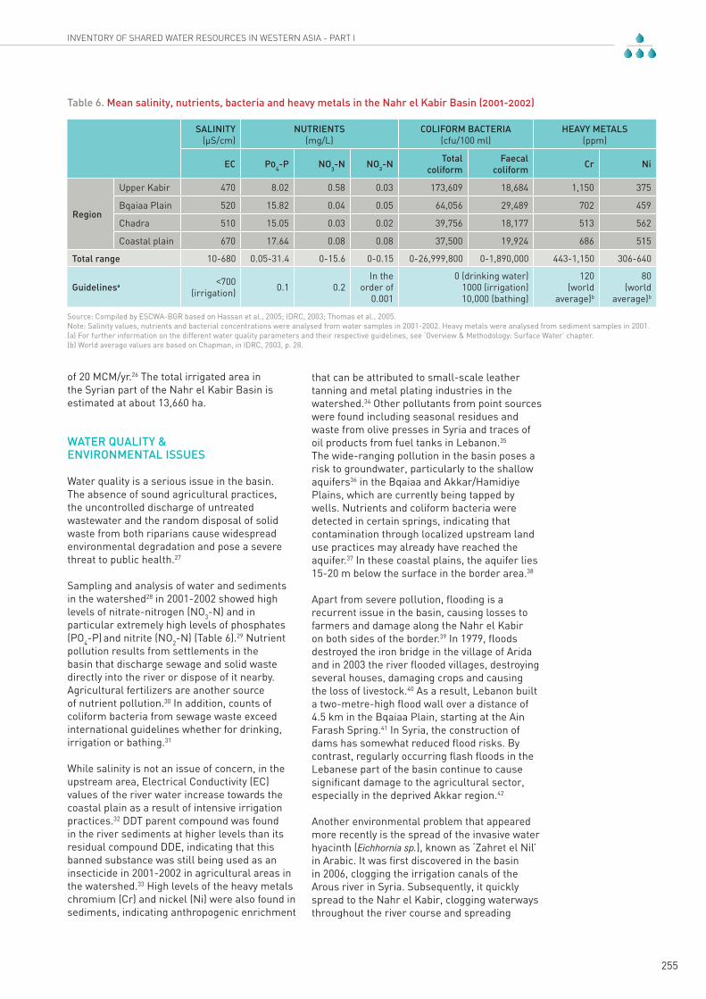
Sampling and analysis of water and sediments in the watershed28 in 2001-2002 showed high levels of nitrate-nitrogen (NO3-N) and in particular extremely high levels of phosphates (PO4-P) and nitrite (NO2-N) (Table 6).29 Nutrient pollution results from settlements in the basin that discharge sewage and solid waste directly into the river or dispose of it nearby. Agricultural fertilizers are another source of nutrient pollution.30 In addition, counts of coliform bacteria from sewage waste exceed international guidelines whether for drinking, irrigation or bathing.31
While salinity is not an issue of concern, in the upstream area, Electrical Conductivity (EC) values of the river water increase towards the coastal plain as a result of intensive irrigation practices.32 DDT parent compound was found in the river sediments at higher levels than its residual compound DDE, indicating that this banned substance was still being used as an insecticide in 2001-2002 in agricultural areas in the watershed.33 High levels of the heavy metals chromium (Cr) and nickel (Ni) were also found in sediments, indicating anthropogenic enrichment
that can be attributed to small-scale leather tanning and metal plating industries in the watershed.34 Other pollutants from point sources were found including seasonal residues and waste from olive presses in Syria and traces of oil products from fuel tanks in Lebanon.35
The wide-ranging pollution in the basin poses a risk to groundwater, particularly to the shallow aquifers36 in the Bqaiaa and Akkar/Hamidiye Plains, which are currently being tapped by wells. Nutrients and coliform bacteria were detected in certain springs, indicating that contamination through localized upstream land use practices may already have reached the aquifer.37 In these coastal plains, the aquifer lies 15-20 m below the surface in the border area.38
Apart from severe pollution, flooding is a recurrent issue in the basin, causing losses to farmers and damage along the Nahr el Kabir on both sides of the border.39 In 1979, floods destroyed the iron bridge in the village of Arida and in 2003 the river flooded villages, destroying several houses, damaging crops and causing the loss of livestock.40 As a result, Lebanon built a two-metre-high flood wall over a distance of 4.5 km in the Bqaiaa Plain, starting at the Ain Farash Spring.41 In Syria, the construction of dams has somewhat reduced flood risks. By contrast, regularly occurring flash floods in the Lebanese part of the basin continue to cause significant damage to the agricultural sector, especially in the deprived Akkar region.42
Another environmental problem that appeared more recently is the spread of the invasive water hyacinth (Eichhornia sp.), known as ‘Zahret el Nil’ in Arabic. It was first discovered in the basin in 2006, clogging the irrigation canals of the Arous river in Syria. Subsequently, it quickly spread to the Nahr el Kabir, clogging waterways throughout the river course and spreading
SALINITY(µS/cm)
NUTRIENTS(mg/L)
COLIFORM BACTERIA(cfu/100 ml)
HEAVY METALS(ppm)
EC P04-P NO3-N NO2-N Total coliform
Faecal coliform Cr Ni
Region
Upper Kabir 470 8.02 0.58 0.03 173,609 18,684 1,150 375
Bqaiaa Plain 520 15.82 0.04 0.05 64,056 29,489 702 459
Chadra 510 15.05 0.03 0.02 39,756 18,177 513 562
Coastal plain 670 17.64 0.08 0.08 37,500 19,924 686 515
Total range 10-680 0.05-31.4 0-15.6 0-0.15 0-26,999,800 0-1,890,000 443-1,150 306-640
Guidelinesa <700 (irrigation) 0.1 0.2
In the order of
0.001
0 (drinking water)1000 (irrigation)10,000 (bathing)
120(world
average)b
80(world
average)b
Source: Compiled by ESCWA-BGR based on Hassan et al., 2005; IDRC, 2003; Thomas et al., 2005.Note: Salinity values, nutrients and bacterial concentrations were analysed from water samples in 2001-2002. Heavy metals were analysed from sediment samples in 2001.(a) For further information on the different water quality parameters and their respective guidelines, see ‘Overview & Methodology: Surface Water’ chapter.(b) World average values are based on Chapman, in IDRC, 2003, p. 28.
Table 6. Mean salinity, nutrients, bacteria and heavy metals in the Nahr el Kabir Basin (2001-2002)

CHAPTER 8 - NAHR EL KABIR BASIN WATER RESOURCES MANAGEMENT
256
over a distance of 13 km.43 It is not known how this non-native aquatic weed was introduced in Syria.44 The damage caused is considerable since it can double its population in two weeks and it rises to a height of up to one metre above the water surface, blocking sunlight to and oxygenation of aquatic organisms and disturbing river flow. It is therefore considered a potential cause of flooding. The plant also creates a prime
habitat for mosquitoes, which are potential vectors of disease in the basin. Both riparian countries have attempted to use excavators to remove the plant from the river and thus control its spread. However, despite continuous joint efforts to control it, the nutrient-rich discharge of agricultural runoff and sewage waste into the Nahr el Kabir has favoured the survival of this invasive plant.
The invasive water hyacinth, which is clogging water channels in the basin, 2009. Source: Ministry of Energy and Water in Lebanon.
257
INVENTORY OF SHARED WATER RESOURCES IN WESTERN ASIA - PART I
AGREEMENTS
The Fraternity, Cooperation and Coordination Treaty signed and ratified by Lebanon and Syria in 1991 provides the formal basis for cooperation in the domain of water and in other sectors. Several joint entities were established in the same year to supervise the implementation of the treaty’s provisions and agreements.45 This includes the Lebanese-Syrian Joint Committee for Shared Water, in which the Lebanese Ministry of Energy and Water and the Syrian Ministry of Irrigation are represented.
In April 2002, after an eight-year negotiation process,46 both countries agreed to share the water of the Nahr el Kabir. The agreement draws on the United Nations Convention on the Law of Non-Navigational Uses of International Watercourses,47 to which both countries are signatories. The agreement is centred on the joint construction of a multi-purpose dam near Noura al Tahta with a planned storage capacity of 70 MCM that will provide water mainly for irrigation and domestic use. According to the agreement, water allocation follows each riparian country’s share in the catchment area that drains to the dam location (representing a total area of 591 km2).48 Thus Lebanon and
Agreements, Cooperation & Outlook
Progress on the Joint Noura al Tahta Dam ProjectThe Lebanese Ministry of Energy and Water invited international tenders for the study and design of the dam in December 2003. In November 2004, the contract was pre-awarded to a Swiss-Lebanese consortium, pending approval by the Syrian and Lebanese governments. The Lebanese Council of Ministers only approved the contract in February 2006, and due to administrative delays and the prevailing political situation in both countries during that period, the necessary funds were not made available. When the two sides resumed discussions on the dam in 2009, the cost of the project had increased substantially. After several meetings of the joint committee in 2009 and 2010, the parties agreed to prepare a new call for tenders. This was done in January 2011 and resulted in the selection of the same Swiss-Lebanese consortium in June 2011. This was subsequently approved by the Lebanese and Syrian governments. Both parties released funds in August 2011, allowing for the feasibility study to be launched. Subsequent events in Syria have delayed the study. Source: Ministry of Energy and Water in Lebanon, 2011.
BOX
2
Syria respectively receive 40% and 60% of the river’s total annual yield (Article 3 of the agreement). The origin of the water, i.e. the respective contribution of each basin riparian to river flow is not taken into account. The amount of water used upstream of the dam (within the limit of the respective allocation proportions) is to be deducted from the riparian countries’ share of stored water (article 12). Costs of dam construction and engineering studies are to be equally divided between both countries (Article 10).49
Both countries consider the agreement as a model for bilateral cooperation over shared water resources in the Arab region. According to Annex 3 of the agreement, the joint committee is to prepare an annual programme for water use in the basin. However, these annual programmes have yet to be drafted, pending construction of the dam, which have not yet started.
COOPERATION
The Lebanese-Syrian Joint Committee for Shared Water is the central entity through which the two countries cooperate over issues related to shared water resources. The membership of the special joint committee for the Nahr el Kabir is drawn from both countries. The committee comprises two subcommittees. The Sub-Committee for the Control of Water Hyacinth
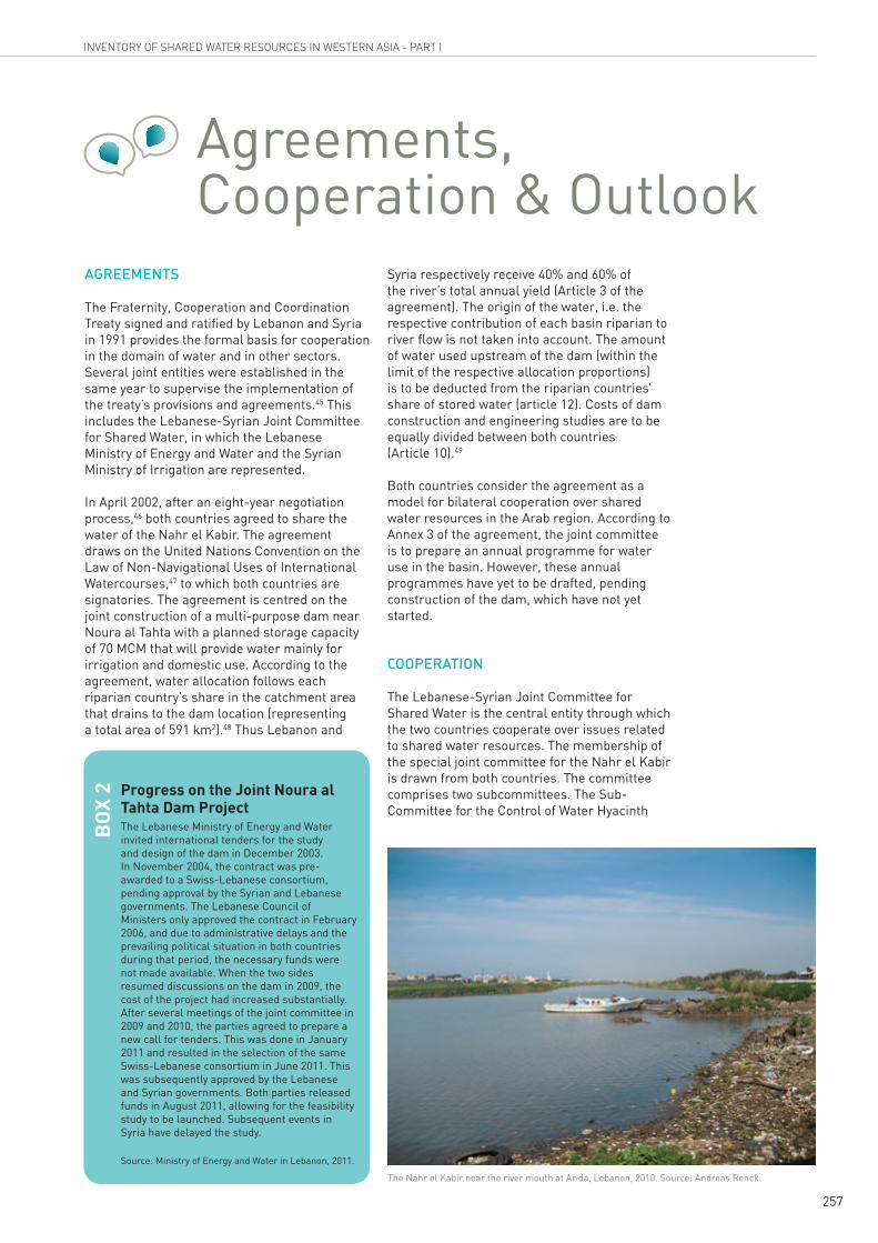
The Nahr el Kabir near the river mouth at Arida, Lebanon, 2010. Source: Andreas Renck.

258
CHAPTER 8 - NAHR EL KABIR BASIN AGREEMENTS, COOPERATION & OUTLOOK
Source: Compiled by ESCWA-BGR based on Ministry of Energy and Water in Lebanon, 2011.
Syrian-Lebanese Higher Council
Syrian-Lebanese Joint Committee for
Shared Water
Nahr el Kabir Joint Committee
Sub-Committee for River Protection
and Environmental Preservation
Sub-Committee for the Control of Water Hyacinth
Committee on River
Hydrology
- Exchange of information on river hydrology- Implementation of hydraulic structures- Coordination of maintenance works on the river and canals- Control of wells for pumping and distribution
- Water quality monitoring- Control of pollution from domestic sources- Coordination of sewage works and solid waste removal from the river
- Regular assessment of the plant’s spread- Coordination of works to remove the plant from waterways- Exchange of information on control measuresControl of
violations and illegal works on the river
Committee on River Pollution
Committee on River
Infringements
Figure 5. Organizational structure and roles of the Nahr el Kabir joint sub-committees
was created in 2009 with the aim of assessing and controlling the spread of this invasive plant. The Sub-Committee for River Protection and Environmental Preservation is responsible for coordinating and supervising issues related to river hydrology, river pollution and river infringements (Figure 5).
Members of the sub-committees usually hold monthly meetings in Lebanon or Syria to exchange data, discuss issues related to the basin and specify joint measures in order to tackle problems such as illegal acts and violations along the river course and river pollution.50
OUTLOOK
The quality of both surface and groundwater in the Nahr el Kabir watershed is rapidly deteriorating due to uncontrolled disposal of untreated domestic sewage, animal waste and solid waste, and unsustainable agricultural practices. To date, joint government efforts to tackle water pollution, floods and illegal activities in the watershed have only offered temporary solutions to recurrent problems. An overall joint plan for the integrated and sustainable management of the basin’s natural resources is still lacking.
Plans for the construction of new wastewater treatment plants in the watershed are under preparation for the region of Al Bireh/Mounjez in Lebanon51 and Tartous Governorate in Syria.52 Both countries have solicited international donors for assistance in water supply management and hydrological monitoring, and various projects were launched. However, with the ongoing crisis in Syria since March 2011, it is likely that some of these projects are currently on hold.

259
INVENTORY OF SHARED WATER RESOURCES IN WESTERN ASIA - PART I
Notes1. IDRC, 2003; UN-ESCWA and BGR, 2009, p. 8.
2. UN-ESCWA, 2006; Khawlie et al., 2005.
3. Comair, 2009, p. 210; Ministry of Irrigation in the Syrian Arab Republic, 2011; Ministry of Irrigation in the Syrian Arab Republic, 2010, p. 149.
4. UNESCO, 2004; Comair, 2009.
5. UNESCO, 2004; UN-ESCWA and BGR, 2010.
6. Lebanese Ministry of Public Works in Shaban et al., 2005.
7. NCRS and UN-ESCWA, 2002; Shaban et al., 2005; IDRC, 2003.
8. Khawlie et al., 2005; IDRC, 2003, p. 17.
9. Shaban et al., 2005, p. 94.
10. UN-ESCWA and BGR, 2010, p. 17, 23.
11. The Homs Gap is a large north-east/south-west strike-slip fault, which separates the Coastal Mountains in Syria from the Lebanon and Anti-Lebanon Mountains.
12. IDRC, 2003.
13. Syrian-Lebanese Higher Council, 2002.
14. IDRC, 2003.
15. Shaban et al., 2005, p. 95.
16. UNESCO, 2004, p. 3.
17. UN-ESCWA and BGR, 2010, p. 17.
18. UNESCO, 2004, p. 2, 3.
19. UN-ESCWA and BGR, 2010, p. 17.
20. The Yammouneh Fault, which belongs to the Dead Sea Transform Fault System (DSTF) (UNESCO, 2004, p. 2).
21. IDRC, 2003.
22. Hreiche, 2009, p. 15, 24.
23. Ministry of Energy and Water in Lebanon, 2000.
24. Ministry of Irrigation in the Syrian Arab Republic, 2006; World Bank, 2001.
25. Ministry of Irrigation in the Syrian Arab Republic, 2011; Al-Thawra, 2011.
26. World Bank, 2001, p. 96; Syrian Economic News, 2010.
27. IDRC, 2003; Syrian-Lebanese Higher Council, 2011.
28. The study was conducted by IDRC, 2003. Samples were taken from both riparians.
29. IDRC, 2003.
30. Hassan et al., 2005.
31. IDRC, 2003, p. 44.
32. IDRC, 2003.
33. Ibid. Banned in 1972, DDT (dichlorodiphenyltrichloroethane) was commonly used as a pesticide and can persist in the environment for many years. It is toxic to a wide range of animals, insects and aquatic organisms. It can also accumulate in the food chain and is considered a human carcinogen (US-EPA, 2011).
34. Thomas et al., 2005; IDRC, 2003.
35. Syrian-Lebanese Higher Council, 2004.
36. The Upper Basalt Alluvium Aquifer System.
37. IDRC, 2003.
38. IDRC, 2003; UNESCO, 2004.
39. UN-ESCWA, 2006.
40. Lebanese Army Magazine, 2003.
41. Ministry of Energy and Water in Lebanon, 2011.
42. Al-Diyar, 2011; Sada Akkar, 2010.
43. SANA, 2010; Tishreen, 2009.
44. The water hyacinth was brought from its native home in South America to various countries as an ornamental plant. It was introduced to the United States of America in the 1980s and to Africa in the 1950s, where it spread to the Congo, the Nile and Lake Victoria (Columbia University, 2003).
45. Syrian-Lebanese Higher Council, 1991.
46. UN-ESCWA, 2006, p. 15.
47. Comair, 2003.
48. The respective riparian shares are allocated based on the following surface areas: 360 km2 of the total area in Syria (63%), and 231 km2 in Lebanon (37%) (Ministry of Energy and Water in Lebanon, 2011; Ministry of Irrigation in the Syrian Arab Republic, 2011).
49. Syrian-Lebanese Higher Council, 2002.
50. Ministry of Energy and Water in Lebanon, 2011.
51. Tidière, 2009, p. 7, 27; Council for Development and Reconstruction in Lebanon, 2011.
52. Syrian-Lebanese Higher Council, 2011.

260
CHAPTER 8 - NAHR EL KABIR BASIN BIBLIOGRAPHY
BibliographyAl- Diyar. 2011. Heavy Rains Turned Streets into River Streams and Akkar Border Towns Fear the Flood of the El-Kabir River. Issued on August 14, 2011. Beirut. Available at: http://www.aldiyaronline.com/index.php/article-details/45618. Accessed on August 31, 2011. ȯǞƈƄů ǀƁȢȶNjƑȚȤƾƳŸ ȝȚNjƴŮ ǍƷſȖ ȸȤƾƆž ǟŽȘ ȬȤȚǞƪŽȚ ǁŽǞŲ ȜǍƁǎưŽȚ ȤƾƭžLjȚ ȤƾƁNjŽȚ.ǍƸƃƳŽȚ ǍƷƶŽȚ ȴƾƬƸź ǜž
Al-Thawra. 2011. After the Bridges, Roads and the Train, the Hands of Sabotage Reach Agriculture, Water and Oil. Haitham Mohammed. Issued on July 30, 2011. Damascus. Available at: http://thawra.alwehda.gov.sy/_archive.asp?FileName=30286683220110730015347. Accessed on August 31, 2011. ǓƱƶŽȚȶ ȔƾƓȚȶ ȬȤǎŽȚ ȲǞƭů ƿƁǍƈƄŽȚ ȸȢƾƁȖ ȤƾƭƲŽȚȶ ȝƾŻǍȮƭŽȚȶ ȤǞȮƉƐȚ NjȮƯŮ
Central Administration of Statistics in Lebanon. 2011. Demographic and Social Statistics. Available at: http://www.cas.gov.lb/. Accessed on November 1, 2011.
Central Bureau of Statistics in the Syrian Arab Republic. 2005. General Census, Population in the Areas and Suburbs 2004. Available at: http://cbssyr.org/General%20census/census%202004/pop-man.pdf. Accessed on October 15, 2010.
Central Bureau of Statistics in the Syrian Arab Republic. 2010. Flow Rates of Main Springs. Available at: http://cbssyr.org/yearbook/2010/chapter1-EN.htm. Accessed on September 27, 2011.
Climate Diagrams. 2009. Climate Diagrams. Available at: http://climatediagrams.com/. Accessed on September 20, 2011.
Columbia University. 2003. Water Hyacinth (Eichhornia crassipies). Available at: http://www.columbia.edu/itc/cerc/danoffburg/invasion_bio/inv_spp_summ/water%252520hyacinth.html. Accessed on August 3, 2011.
Comair, F. 2003. Hydrodiplomacy of Middle Eastern countries along with the UN Convention on Non-Navigational Uses of International Watercourses: Case study of Orontus and Nahr El Kabir. In Preparatory Workshop on Enhancing Negotiation Skills on Shared Water Issues for Palestine. Dead Sea.
Comair, F. 2009. Water Management and Hydrodiplomacy in Lebanon. Published by Notre Dame University Press. Zouk Mikayel.
Council for Development and Reconstruction in Lebanon. 2011. Wastewater Sector Program. Available at: http://www.cdr.gov.lb/eng/select_underpreparation_proj_details.asp. Accessed on August 26, 2011.
E-Homs. 2011. Mzeineh Dam Revives the Region’s Economy. Anis Misyati. Issued on February 20, 2011. Homs. Available at: http://www.esyria.sy/ehoms/index.php?p=stories&category=business&filename=201102201025021. Accessed on August 31, 2011. ǀƲƭƶƓȚ ȢƾƫƄŻȚ ǠƸƎ ȜȶǍŰ ǀƶƁǎƓȚ NjŴ
FAO (Food and Agriculture Organization of the United Nations). 1991. Planification Hydro-Agricole du Liban Nord, Plaine du Akkar: Projet de Barrage de Noura Et Tahta sur Nahr El Kebir. In Appui Technique pour la Planification du Développement Agricole et Rural. Beirut.
Hassan, S., Thomas, R. L., Shaban, A. and Khawlie, M. 2005. Phosphorus and Nitrogen in the Waters of the El-Kabir River Watershed in Syria and Lebanon. Lakes and Reservoirs, 2: p. 127-134.
Hreiche, A. 2009. Composante Agronomie, Irrigation et Sécurité Alimentaire. In GWP-Med National Integrated Water Resources Management Plan for Lebanon. Published by GWP-Med (Global Water Partnership-Mediterranean).
IDRC (International Development Research Center). 2003. Institutions for Transboundary Rivers: The Akkar Watershed in Syria and Lebanon, Final Technical Report.
Khawlie, M., Shaban, A., Abdallah, C. and Darwish, T. 2005. Watershed Characteristics, Land Use and Fabric: The Application of Remote Sensing and Geographical Information Systems. Lakes and Reservoirs, 10: p. 85-92.
Lebanese Army Magazine. 2003. Many Goods but Many Losses Also. Issued in March 2003. Available at: http://www.lebarmy.gov.lb/article.asp?ln=ar&id=1852. Accessed on January 12, 2012. ƾƬƁȖ ǍǣƾƉƒȚȶ ǍƸƅż ǍƸƒȚ :ǐƸƐȚ ǀƴƆž
Ministry of Energy and Water in Lebanon. 2000. Construction of Noura Et Tahta Dam on El-Kebir River, Project Summary Report from a Lebanese Perspective. Published by the General Directorate of Hydraulic and Electric Resources in Lebanon.
Ministry of Energy and Water in Lebanon. 2011. Country Consultation with the Republic of Lebanon. In Country Consultations for the Inventory of Shared Water Resources in Western Asia 2011-2012. Beirut.
Ministry of Irrigation in the Syrian Arab Republic. 2006. Executed Dams in the Coastal Basin Till Year 2006. Available at: http://www.irrigation.gov.sy/index.php?d=116. Accessed on August 3, 2011. ȉȇȇȍ ȳƾŸ ǟƄŲ ǚŲƾƉŽȚ ȩǞŲ Ǡź ȜnjƱƶƓȚ ȢȶNjƉŽȚ
Ministry of Irrigation in the Syrian Arab Republic. 2010. The Syrian-Lebanese Experience on Water Management in the Orontes and El-Kabir Basin. In Proceedings of the Third Meeting of the Technical Scientific Advisory Committee of the Arab Ministerial Water Council. Cairo. Available at: www.arableagueonline.org/lasimages/picture_gallery/reportes29-30june2009.pdf. Accessed on July 17, 2011.
Ministry of Irrigation in the Syrian Arab Republic. 2011. The Great Southern River. In Country Consultations for the Inventory of Shared Water Resources in Western Asia 2011-2012. Beirut. ǠŮǞƶƐȚ ǍƸƃƳŽȚ ǍƷƶŽȚ
NCRS and UN-ESCWA (National Center for Scientific Research; United Nations Economic and Social Commission for Western Asia). 2002. Hydrological Data on El-Kabir Watershed in Lebanon.
Phytosociological Research Center. 2009. Worldwide Bioclimatic Classification System. Available at: http://www.globalbioclimatics.org/plot/diagram.htm. Accessed on September 20, 2011.
Sada Akkar. 2010. Heavy losses in the Plain of Akkar After Wave of Torrential Rains and Floods. Issued on January 5, 2010. Available at: http://www.sadaakkar.com/2010/01/05/4687.html. Accessed on August 31, 2011. .ȝƾſƾƬƸƱŽȚȶ ȲǞƸƉŽȚ ǀűǞž NjƯŮ ȤƾƳŸ ǚƷŴ Ǡź ǀƵƸƉű ǍǣƾƉų
SANA (Syrian Arab News Agency ). 2010. Continuing Efforts to Control Zahret el Nil in Rivers of Abrash, Arous, El-Kabir and Orontes. Wael Hawija. Issued on February 3, 2010. Damascus. Available at: http://www.sana.sy/ara/82/2010/02/03/270661.htm. Accessed on August 31, 2011. ǍƸƃƳŽȚȶ ȦȶǍƯŽȚȶ ȧǍŮLjȚ ȤƾƷſȖ Ǡź ǚƸƶŽȚ ȜǍƀȥ ǀƃƪŸ ǀƇźƾƳž ǀƯŮƾƄžǠǧƾƯŽȚȶ ǠŮǞƶƐȚ
Shaban, A., Khawlie, M. and Abdallah, C. 2005. Hydrological and Watershed Characteristics of the El-Kabir River, North Lebanon. Lakes and Reservoirs, 10: p. 93-101.
Syrian-Lebanese Higher Council. 1991. Fraternity, Cooperation and Coordination Treaty. Available at: http://www.syrleb.org/docs/agreements/01TREATYeng.pdf. Accessed on August 28, 2011.

261
INVENTORY OF SHARED WATER RESOURCES IN WESTERN ASIA - PART I
Syrian-Lebanese Higher Council. 2002. Agreement between the Syrian Arab Republic and Lebanon for Sharing the Water of the Al-Kabir Al-Janoubi River and for Building a Joint Dam on the Main Watercourse. Available at: http://www.syrleb.org/docs/agreements/31%20%20ALJANUBEH%20RIVER.pdf. Accessed on August 28, 2011.ȩǞŲ ȵƾƸž ȳƾƉƄŻǽ ǀƸſƾƶƃƴŽȚ ǀƁȤǞƷƵƐȚȶ ǀƁȤǞƉŽȚ ǀƸŮǍƯŽȚ ǀƁȤǞƷƵƐȚ ƞŮ ǀƸŻƾƱůȘ ǍƷƶƴŽ ǠƉƸǣǍŽȚ ȷǍƣȚ ǟƴŸ ȱǍƄƪž NjŴ ȔƾƶŮȶ ǠŮǞƶƐȚ ǍƸƃƳŽȚ ǍƷƶŽȚ
Syrian-Lebanese Higher Council. 2004. Joint Committee’s Meeting Records 2004. Available at: http://www.syrleb.org/reports/2004/committees2004_3.asp. Accessed on September 2, 2011. ȉȇȇȋ ȳƾŸ ȲǾų ǀƁȤǞƉŽȚ ǀƸſƾƶƃƴŽȚ ȴƾƆƴŽȚ ȲƾƵŸȖ
Syrian-Lebanese Higher Council. 2011. Joint Sub-Committee’s Meeting Records 2004-2011. ǀƸŸǍƱŽȚ ȴƾƆƴŽȚ ȝƾŸƾƵƄűȚ ǍǤƾƇž
Syrian Economic News. 2010. After Four Decades, 11% of the Akkar Plain Area in Syria Remains Unexploited. Issued on April 21, 2010. Available at: http://sensyria.com/index.php?rto=901&id=773. Accessed on August 31, 2011. ƾƸŸȚȤȥ ȜǍƵƅƄƉž ǍƸŹ ȤƾƳŸ ǚƷŴ ǀŲƾƉž ǜž ǀƂƓȚ Ǡź ȈȈ ȢǞƲŸ ǀƯŮȤȖ NjƯŮ
Thomas, R. L., Shaban, A. and Khawlie, M. 2005. Geochemistry of the Sediments of the El-Kabir River and Akkar Watershed in Syria and Lebanon. Lakes and Reservoirs, 10: 127-134.
Tidière, A. 2009. Composante Assainissement. In GWP-Med National Integrated Water Resources Management Plan for Lebanon. Published by GWP-Med (Global Water Partnership-Mediterranean).
Tishreen. 2009. Zahrat El Nil Threatens Tartous Rivers Hitting Nahr El Kebir, Nahr Abrash and Nahr Arous. Aida Dyoub. Issued on December 29, 2009. Available at: http://www.4geography.com/vb/t2631.html. Accessed on August 31, 2011. ȧǍŮLjȚ ǠŮǞƶƐȚ ǍƸƃƳŽȚ ǁŮƾǧȖ ƾƬƁȖ ȦǞŶǍŶ ȤƾƷſȖ ȢNjƷů ȜǍƸƭƒȚ ǚƸƶŽȚ ȜǍƀȥ ǜƁǍƪů ȦȶǍƯŽȚȶ
UN-ESCWA (United Nations Economic and Social Commission for Western Asia). 2006. Regional Cooperation Between Countries in the Management of Shared Water Resources: Case Studies of Some Countries in the ESCWA Region. New York.
UN-ESCWA and BGR (United Nations Economic and Social Commission for Western Asia; Bundesanstalt für Geowissenschaften und Rohstoffe). 2010. Assessment of the Project Area and Recommendations for Initial Technical Measures Vol. 2. In ESCWA-BGR Technical Assistance Program: Support to the Republic of Lebanon. Unpublished work.
UN-ESCWA and BGR (United Nations Economic and Social Commission for Western Asia; Bundesanstalt für Geowissenschaften und Rohstoffe). 2009. Preliminary Assessment of Hydrological Monitoring Needs for the Nahr El Kabir El Jnoubi in Lebanon Vol. 1 (Draft). In ESCWA-BGR Technical Assistance Program: Support to the Republic of Lebanon. Unpublished work.
UNESCO (United Nations Educational Scientific and Cultural Organization). 2004. Report: Nahr el-Kabir Basin (Lebanon, Syria) Consensus Building for Integrated Management, Main Characteristics of the Basin. In Water: A Catalyst for Peace. Zaragossa. Available at: http://www.unesco.org/water/wwap/pccp/zaragoza/basins/nahr_el_kabir/nahr_el_kabir.pdf. Accessed on October 10, 2009.
US-EPA (United States Environmental Protection Agency). 2011. DDT. In Persistent Bioaccumulative and Toxic (PBT) Chemical Program. Available at: http://www.epa.gov/pbt/pubs/ddt.htm. Accessed on December 19, 2011.
World Bank. 2001. Syrian Arab Republic Irrigation Sector Report. In Rural Development, Water and Environment Group, Middle East and North Africa Region.
WorldClim. 2011. Global Climate Data. Available at: http://www.worldclim.org. Accessed on September 20, 2011.