Embed Size (px)
Citation preview

———River Corridor and Watershed Management———
14-1
Chapter 14 River Corridor and Watershed Management Chapter Overview There is a growing interest among those concerned and involved in managing flood-prone lands to broaden the area of interest beyond the regulatory floodplain, to look at the entire river corridor or even encompass total watershed management. This allows inclusion of multiple management objectives and approaches. This chapter examines some objectives and approaches that can contribute to broader floodplain management.
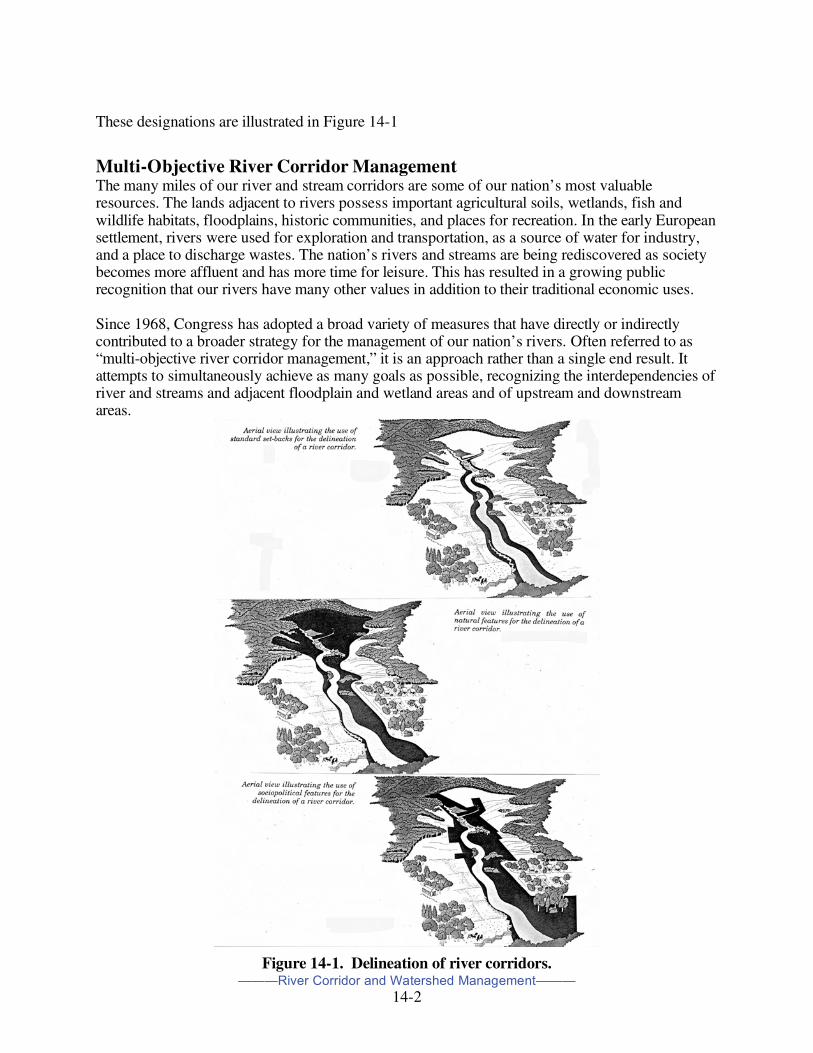
Designation of River Corridors A river (or stream) corridor includes the width of the channel in which water flows and is typically expanded to account for the extensive influence of the watercourse into the surrounding landscape. Corridors are of vital importance in that they help preserve those qualities that make a river or stream suitable as a habitat for wildlife, a site for recreation, and a source for domestic and other water uses. These corridors also allow the free movement of wildlife from area to area within the region, help control erosion and river sedimentation, and help absorb floodwaters. The river corridor is a diverse zone in terms of its scale, situation, and character, and is one that may have already been heavily modified by human activity. Corridors may be designated in a number of ways, including specified distances from the watercourse, physiographic features, or inclusion of the boundaries of land units. Corridors may be designated as specified distances or setbacks from the river or stream, such as 200 or 500 feet from the stream bank, or edge or center of the watercourse. There are a number of factors that enter into the decision-making process of determining the setback distances including political and public interest and support. Utilizing physiographic features, at one end of the spectrum the corridor may comprise a narrow strip of riparian vegetation separating the upland from the stream channel. At the other end, the corridor may consist of a wide and complex floodplain including many landscape units. Because stream channels move due to natural processes such as meandering, riverbank erosion, and creation of new channels, river corridors based on physiographic features may shift with time. Corridors may be further designated by boundaries of land units such as vegetated buffers, riparian forests, wetlands, and other important land features. Finally, they may encompass local units of government wishing to provide an added degree of land use planning and developmental control. .
———River Corridor and Watershed Management———
14-2
These designations are illustrated in Figure 14-1
Multi-Objective River Corridor Management The many miles of our river and stream corridors are some of our nation’s most valuable resources. The lands adjacent to rivers possess important agricultural soils, wetlands, fish and wildlife habitats, floodplains, historic communities, and places for recreation. In the early European settlement, rivers were used for exploration and transportation, as a source of water for industry, and a place to discharge wastes. The nation’s rivers and streams are being rediscovered as society becomes more affluent and has more time for leisure. This has resulted in a growing public recognition that our rivers have many other values in addition to their traditional economic uses. Since 1968, Congress has adopted a broad variety of measures that have directly or indirectly contributed to a broader strategy for the management of our nation’s rivers. Often referred to as “multi-objective river corridor management,” it is an approach rather than a single end result. It attempts to simultaneously achieve as many goals as possible, recognizing the interdependencies of river and streams and adjacent floodplain and wetland areas and of upstream and downstream areas.
Figure 14-1. Delineation of river corridors.
———River Corridor and Watershed Management———
14-3
Beyond federal initiatives, a number of states have enacted measures to protect shorelands and coastal and freshwater wetlands. Local efforts include a broad range of greenway programs. Many involve urban renewal and the restoration of historic and abandoned or dilapidated buildings for riverfront commercial or residential use. Others involve the creation of parks, golf courses, bike and walking paths, and the restoration or improvement of historic properties to maintain the community’s heritage. Multi-objective management takes what is known about water resources, geomorphology, and ecology in arriving at “consensus” ways to manage the water resource and adjacent floodplains, and broader stream and river corridors as integrated and inter-related landscape features. The resulting actions maximize public and private benefits with the least impacts on significant river resources.
Interest in Multi-Objective River Corridor Management There are several causes or reasons for this growing interest. Over the past few decades better procedures have been developed to identify and document the natural and beneficial resources and values contained within river corridors including impact analysis, i.e., not only the extent of benefits these resources provide but also how they can be impacted, impaired, or even lost. The passage of various federal acts and administrative actions (described in Chapter Eleven) have helped to give formal recognition to the environmental aspects of floodplain management and the broader river corridor, and to establish a conceptual and management framework. There are increasing (although yet limited) levels of interdisciplinary and intergovernmental cooperation. Most riverine wetlands are located within floodplains, and wetlands managers, floodplain managers, and other natural resources managers are discovering that they are involved in the same areas and have many common interests and needs. But much remains to be done. There is still a significant polarization of positions, missions, and interests. Some managers have already recognized, and others are discovering that existing management approaches are not working well or as effective as they could or should be working. Most floodplain management objectives and practices use existing watershed and floodplain conditions to determine areas of involvement; generally deal with controlling future development; do little for existing problems; look at only a small portion of the floodplain and river corridor (i.e., the 1-percent annual chance flood); and are typically single purpose, i.e., flood loss reduction. Community and citizen interest in floodplain management for flood loss reduction is lukewarm at best. Most programs exist because of a state mandate or requirement to participate in the National Flood Insurance Program. Because of the perceived unlikelihood of occurrence of the regulatory flood (e.g., “100-year” flood) and the prevailing view that after a flood, government at a higher level will bail them out by restoring everything to pre-flood conditions or more likely even better, bigger, and stronger, any support is often tacit. Putting together multipurpose management plans and programs to meet a number of community needs helps broaden the political and public support needed for success. This includes being able to put together funding packages where resources and support are not adequate for single-objective approaches.
———River Corridor and Watershed Management———
14-4
There are a number of trends resulting from a renewed interest in managing river corridors to meet multiple objectives.1 ∞ The objectives of floodplain management have been broadened to recognize the need to protect
natural floodplain resources as well as reduce flood losses. ∞ The public desires more involvement in making decisions about projects that affect them and
their communities. ∞ Rivers in urban areas, often associated with historic and cultural features, are increasingly seen
as the foundation for community revitalization efforts. ∞ There is renewed interest in recreational opportunities associated with rivers in metropolitan
areas. ∞ Changing sources of funding for flood control projects require that projects meet a broader
range of objectives. ∞ An increasing number of designs for flood protection projects are based on the workings of
natural hydrologic systems. A key feature, essential to the success of these projects, is the development of cooperative public and private partnerships. Differing projects have different supporters; incorporating multiple objectives into the planning process results in a broad base of support. These partnerships typically involve federal, state and local governments; landowners; businesses; conservationists; and recreationists. Not only do these partnerships ensure that a broad range of interests are addressed in planning, but they also bring funding, expertise, and other critical resources. Ultimately, partnerships bring the public support necessary for long-term success.
The importance of river corridors warrants a well thought out and balanced management approach. Emphasis is often placed on flood hazard protection, but includes multiple objectives such as improving or maintaining water quality, protecting wetlands, maintaining natural hydrological processes, maintaining riparian vegetation, providing water supply and navigation, enhancing fish and wildlife habitat, improving recreation opportunities, and encouraging compatible economic development.
Why Multi-Objective River Corridor Management2 The use of rivers and their adjacent lands for a variety of uses to serve a broad variety of objectives is not new. They typical pattern of use of rivers and streams and adjacent lands is one of piecemeal agricultural, forestry, residential, commercial, industrial, and other uses along the length of the river or stream and tiered back from the water along the floodplain. Although rivers and their adjacent lands have been used for many purposes, attempts are relatively rare to simultaneously achieve multiple objectives for particular river segments or to interrelate planning and activities on various river segments. Multi-objective river corridor management takes the multiple use concept a step further to relate activities throughout the length of a river and for the river, the bank, and the adjacent floodplain. It is an integrated approach that attempts to maximize multi-objective values for each reach of the river and parcel of land, while recognizing relationships between parcels and segments.
1 Taken from “A Casebook in Managing Rivers for Multiple Uses,” National Park Service, 1991. 2 Much of the following discussion is based on a paper “Multiobjective River Corridor Management: An Introduction to Issues: Recommendations for Implementing Programs,” Jon Kusler, Association of Wetland Managers, circa early 1990s
———River Corridor and Watershed Management———
14-5
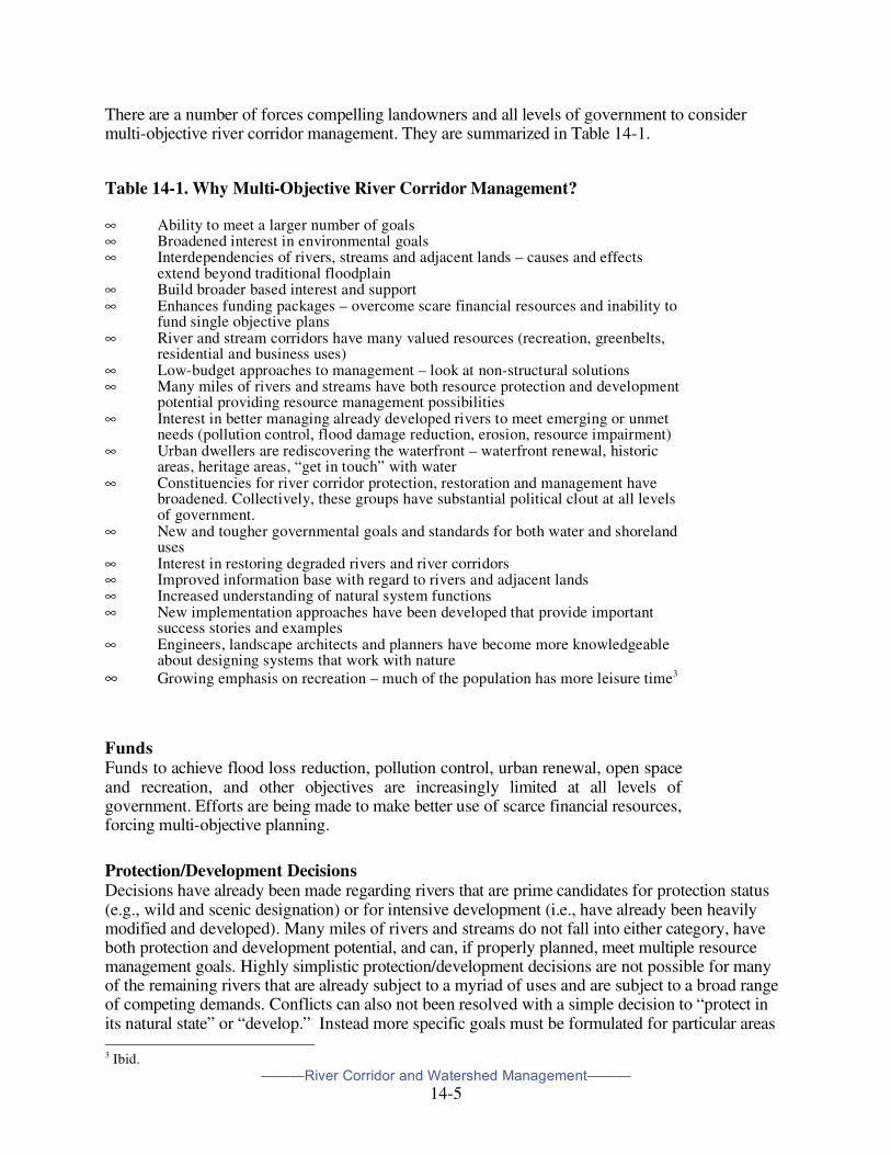
There are a number of forces compelling landowners and all levels of government to consider multi-objective river corridor management. They are summarized in Table 14-1.
Table 14-1. Why Multi-Objective River Corridor Management? ∞ Ability to meet a larger number of goals ∞ Broadened interest in environmental goals ∞ Interdependencies of rivers, streams and adjacent lands – causes and effects
extend beyond traditional floodplain ∞ Build broader based interest and support ∞ Enhances funding packages – overcome scare financial resources and inability to
fund single objective plans ∞ River and stream corridors have many valued resources (recreation, greenbelts,
residential and business uses) ∞ Low-budget approaches to management – look at non-structural solutions ∞ Many miles of rivers and streams have both resource protection and development
potential providing resource management possibilities ∞ Interest in better managing already developed rivers to meet emerging or unmet
needs (pollution control, flood damage reduction, erosion, resource impairment) ∞ Urban dwellers are rediscovering the waterfront – waterfront renewal, historic
areas, heritage areas, “get in touch” with water ∞ Constituencies for river corridor protection, restoration and management have
broadened. Collectively, these groups have substantial political clout at all levels of government.
∞ New and tougher governmental goals and standards for both water and shoreland uses
∞ Interest in restoring degraded rivers and river corridors ∞ Improved information base with regard to rivers and adjacent lands ∞ Increased understanding of natural system functions ∞ New implementation approaches have been developed that provide important
success stories and examples ∞ Engineers, landscape architects and planners have become more knowledgeable
about designing systems that work with nature ∞ Growing emphasis on recreation – much of the population has more leisure time3
Funds Funds to achieve flood loss reduction, pollution control, urban renewal, open space and recreation, and other objectives are increasingly limited at all levels of government. Efforts are being made to make better use of scarce financial resources, forcing multi-objective planning.
Protection/Development Decisions Decisions have already been made regarding rivers that are prime candidates for protection status (e.g., wild and scenic designation) or for intensive development (i.e., have already been heavily modified and developed). Many miles of rivers and streams do not fall into either category, have both protection and development potential, and can, if properly planned, meet multiple resource management goals. Highly simplistic protection/development decisions are not possible for many of the remaining rivers that are already subject to a myriad of uses and are subject to a broad range of competing demands. Conflicts can also not been resolved with a simple decision to “protect in its natural state” or “develop.” Instead more specific goals must be formulated for particular areas 3 Ibid.
———River Corridor and Watershed Management———
14-6
reflecting a broad range of factors including, in some instances, restoration of degraded river and adjacent corridor areas.
Interest now extends to small streams. Interest has broadened to include smaller rivers, streams, and creeks for a number of reasons. They are often the sources of pollution and it is impossible to improve water quality on the larger rivers without addressing problems at their source. Many of the prime wetlands, wildlife areas, and habitats lie along these watercourses. Increased runoff from these watercourses in urbanized or urbanizing areas is, collectively, greatly increasing flood peaks on larger rivers and streams. Finally, there are the increasing focus for water-oriented recreation and for use of their shorelines for hiking, nature watching, picnicking, and other leisure activities.
Interest has shifted to urban environments. At one time there was little interest in urban rivers and streams except for development purposes (warehouses, docks, ports). With improved water quality and shifting public needs, interest has shifted in cities throughout the nation to restoration of waterfronts and protection of undeveloped areas, restoration of historic buildings and “heritage” areas, providing parks and recreation areas, and enhancing the economic values of riverfront areas for residential and commercial use. In the past few decades many of the most innovative river and river corridor restoration efforts have involved urban environments.
Constituencies have broadened. At one time, the major proponents of river management were navigation interests, commercial and industrial developers, boaters, and flood loss reduction planners and engineers. Over the past quarter century these groups were joined by many others – nature watchers; recreationists; owners of businesses and lodging desiring an attractive nearby river or stream environment; residential developers also desiring an attractive environment for homes; and floodplain and wetland managers. Collectively, these groups have substantial political clout at all levels of government. Legislative goals have broadened. Due to broadened public interests and concerns, the legislative goals for river and adjacent river corridor management have broadened. New federal, state, and local regulations have been adopted that codify these goals and provide new, tougher standards for water and shoreland uses.
Federal aid has been reduced. Also during the past quarter century federal and state subsidies and grants in aid for flood control measures and recreational land acquisition have been dramatically reduced. Congress has approved few projects. In addition, state or local cost-sharing requirements have been increased. These changes, combined with tight budgets and fiscal restraints at state and local levels have required increased use of low budget approaches to river and river corridor management that combine flood loss reduction, recreation, and water quality treatment with efforts to appeal to a broader range of constituencies in communities.
Information base greatly improved. The information base with regard to rivers and adjacent lands has been greatly improved. This improved database facilitates detailed assessment, modeling, and implementation efforts. Flood studies have been carried out by FEMA for some 20,000 communities, wetland maps have been prepared for most riverine areas at part of the National Wetland Inventory, rare and endangered

———River Corridor and Watershed Management———
14-7
species habitat has been identified by the U.S. Fish and Wildlife Service and state natural resource agencies, and areas of natural diversity, historic importance, and special scientific interest have been identified and mapped by state Natural Heritage Programs and private efforts.
Technological advances. Technological advances in science and engineering have been made and scientific understanding of natural system functions and nonstructural approaches has increased. Over the past few decades, significant advances in knowledge have been made with regard to a broad range of assessment methods, modeling and planning approaches, and implementation techniques for floodplain, wetland, and wildlife management. This includes “soft” and bioengineering techniques to achieve flow levels and for bank stabilization and park design. Today the planner or engineer wishing to achieve multi-objective goals in river and river corridor management has a much broader range of techniques. Much of the “how” with regard to multi-objective river corridor management in now available, although this information has not been broadly disseminated.
New implementation approaches. In the past few decades, local governments and states have developed a variety of new and innovative approaches for goal-setting in particular river and river corridor contexts, and for planning, coordination of programs, constituency building, and financing of efforts. These have included various special area management planning approaches, river corridor planning efforts for particular rivers or segments of rivers, stormwater planning and management programs, stormwater utility approaches, and other financing mechanisms.
Pro-Active Federal programs. Among the leaders in promoting and facilitating Multi-objective River corridor management has been the National Park Service. Under its Rivers, Trails, and Conservation Assistance program, the “Riverwork” process assists communities in collaborative planning for their river corridors. While their work has occurred “in the context of the larger watershed,” the focus has been the river segment and its immediate environs. Information on the Service’s program may be found at their website: www.ncrc.nps.gov/rtca.
Impediments Despite the advantages, multi-objective river corridor management efforts face a number of impediments.
Traditional approaches have great momentum. Many factors favor continuation of old approaches. It is perhaps human nature to apply “familiar” solutions to problems. Traditional engineering approaches are all that many design professionals (engineers, water resources planners) know. Such approaches are the only ones that have been taught in an academic environment. In addition, engineers have a fear of liability in applying new designs that may not perform as anticipated. Beyond this, the entire set of relationships that water resources agencies, engineers, and contractors have developed over a period of years tends to support traditional approaches. Traditional engineering projects often involve substantial contracting and jobs for an area. Natural area protection approaches typically do not.
———River Corridor and Watershed Management———
14-8
Traditional programs continue to have single or few purposes. Individual government programs usually continue to be designed to serve a primary objective or a small number of objectives. Given limited statutory or program objectives, it is often difficult for staff of single-objective agencies to undertake multi-objective projects, fund such projects, or even provide technical assistance for such projects. There are few incentives for coordination among agencies, and, in many instances, out and out turf battles when one agency attempts to do something that overlaps with activities of another agency. Multi-objective situations may be avoided where jurisdictions overlap.
There is little incentive for cooperation. There is often little incentive for agencies, groups or organizations to cooperate al long as they have sufficient money and/or political support to carry out their missions. Cooperation is often viewed as time-consuming and adding complexity. It may involve compromising “turf” and sharing credit for successful efforts. Cooperative mechanisms may also be lacking or inadequate.
Multidisciplinary expertise is lacking. Individual experts whose skills and knowledge are needed for multidisciplinary assessments, designs, and implementation are not widely available. Those designing river corridor projects often have limited knowledge outside of their immediate areas of expertise. Geologists have some knowledge about bank stability problems but often know little about the biological aspects of river management. Biologists and botanists know little about hydrology, bank stability problems, or engineering design. Engineers often know a fair amount about hydrology and hydraulics, but little about biology or botany. Planners often have limited knowledge of hydrology, hydraulics, geology, botany or biology. Individuals may not only have limited knowledge of these disciplines, but they may view with mistrust or suspicion individuals with other expertise.
Training for multi-objective approaches is inadequate. Despite quite widespread use of various “soft engineering” approaches over the past few decades, there have been limited studies to determine how well such approaches perform in major flood events and little written on the topic. Training in the use of various innovative design techniques has not been provided to planners, engineers, local officials, and other key decision-makers and design professionals.
Limitations exist in data base and modeling capabilities. Most of the data gathering and mapping to date has been for larger rivers and streams with little data available for smaller water bodies. Modeling capabilities have been improved but much remains to be done to develop adequate predictive capability with regard to flood storage and conveyance, erosion, sediment transport, the response of streams to changes in sediment regime, and wetland restoration and creation.
Regulatory standards are inflexible. Inflexible regulatory standards fail to allow innovation and tailoring to factual situations. In some instances, rigid regulations adopted to achieve particular goals such as flood loss reduction may prevent innovative multi-objective approaches. For example, stormwater regulations that require concrete channels, paved detention basins that also serve as parking areas, and below ground systems, may reduce flood losses but they also may prevent the use of above ground grassed
———River Corridor and Watershed Management———
14-9
channels or vegetative detention areas with not only flood conveyance or storage, but water quality protection and maintenance potential.
Funding sources often favor engineering projects. There is often a strong bias toward structural approaches. Funding organizations often include engineers and water resources planners familiar with traditional approaches. These approaches are viewed as “tried and tested.” They favor definable, relatively large-scale “projects” with favorable cost-benefit ratios. Protection of a natural channel and adjacent river corridor, floodplain or wetland often does not meet the conventional concept of a “project.” It might be cost effective in the long run in comparison to an engineering project for reducing flood losses, but benefits must be included for preventing future development (often not considered an acceptable benefit item) in contrast with protecting existing development (an acceptable benefit item).
Jurisdictional authority over river corridor areas is highly fragmented. Efforts to formulate and implement multiobjective projects are often thwarted by the large number of governmental units with jurisdiction over even a modest section (e.g., 30 miles) of a river or stream. These units may include a number of incorporated areas, one or more counties, the state, and one or more federal agencies.
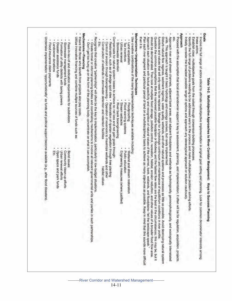
Keys to Success Multi-objective river corridor management involves a balanced consideration of implementation techniques. As stated earlier, it is an approach rather than a single end result. The “keys to success” differ. However, a number of key elements characterize many of these efforts. These are outlined in Table 14-2.4 Many of these recommendations may be grouped under two major headings: A Shift in Philosophy and A Shift in Responsibility.
A Shift in Philosophy First, multi-objective river corridor management requires a philosophical shift not only with regard to goals but to the factors considered and the implementation techniques. There is need to more broadly apply what is known about hydrology, geomorphology, and ecology in creative “consensus” ways to manage waters and adjacent floodplains and wetlands as integrated landscape features. It should be assumed that traditional solutions to river management problems are not necessarily the best approaches for meeting multi-objective river corridor management needs for a particular segment of a river or parcel of land. This does not mean going to “soft engineering” in all instances. Multi-objective management must often be achieved through multi-objective use of each segment of a river rather than allocating different segments to different single purpose uses. This is an important shift in philosophy from one that allocates different sections of the river corridor to different uses, often with little thought of impact on upstream or downstream areas. The general assumptions that the “narrowest possible” floodplain or floodway and the quickest possible movement of water from upstream to downstream points along a stream are desirable should be carefully reevaluated for applicability in specific contexts. Traditionally it has often been assumed that it is in the public interest to reduce the floodplain to as small a conveyance area as possible by deepening the channel, straightening the channel, and reducing the flow resistance
4 Kusler, Ibid.

———River Corridor and Watershed Management———
14-10
through clearing of vegetation and use of concrete. While a reduced conveyance area may be desirable in some instances (e.g., reduction in flood losses to existing structures), a narrow, deep concrete channel destroys wetlands, wildlife, fisheries, accelerates downstream flood flows and potential erosion problems, provides little in the way of recreational opportunities, provides little water quality protection, and is often unaesthetic. Wider, vegetative channels and banks do require more land but may also require less engineering and may have a broad range of other flood storage, pollution control, recreational, aesthetic, habitat, and erosion control benefits. Finally, it should be realized that to achieve multi-objective goals considerable specificity in thinking must take place with an examination of natural resources and functions of floodplain as a whole, and their value to the community and society, and a consideration of geomorphological as well as hydrologic and hydraulic factors. A factually sensitive approach often means more detailed data gathering and analysis for the floodplain as a whole and consideration of factors that have often been ignored in the past.
———River Corridor and Watershed Management———
14-11

———River Corridor and Watershed Management———
14-12
A Shift in Responsibility Second, multi-objective river corridor management often requires not only a philosophical shift in approach but who is responsible for goal-setting, planning, funding, and implementation responsibilities. Successful implementation requires considerable “bottom-up” planning and plan implementation. Local government and landowner initiatives are key. The federal government and states can help, but the major motivation, planning, design, and financing must often take place at the local level. Locals often have the most to gain from multi-objective river corridor management and most to lose from single objective approaches. They also have the greatest incentive to coordinate federal and state technical and financial assistance. A strong bottom-up orientation requires the involvement of landowners and local governments from the beginning, the application of consensus decision-making models, and a division of responsibilities for implementation. It requires power-sharing and new coordinating mechanisms to gain consensus and facilitate implementation.
Conclusion Multi-objective river corridor management is complex and cannot be easily accomplished. But the tools and techniques are available. The long term benefits can be substantial.
Tennessee and Other Statewide River Assessments In the early 1990s the Tennessee Department of Environment and Conservation, with assistance from the U.S. National Park Service’s Rivers, Trails and Conservation Assistance Program (described above), undertook a statewide river assessment. The state was divided into five major watersheds: Barren, Conasauga, Cumberland, Mississippi, and Tennessee. Within the watersheds, data were collected for river corridors based on four categories of interest: ∞ Natural and scenic qualities – the aesthetics of each river corridor ∞ Recreational boating – recreational opportunities in each river corridor ∞ Recreational fishing – identification of river segments containing likely spots for angler
satisfaction ∞ Water quality – status of water quality of each river corridor A report describing the assessment was prepared in the late 1990s but is now out of print. The only information of the assessment is found at the Department of Environment and Conservation website at: http://tennessee/gov/environment/wpc/publications/riv. According to the Summary Report, Introduction, at the website, “The data collected in the Assessment is intended to analyze the strengths and weaknesses of Tennessee’s rivers and enhance planning and management by developing a better understanding of river resources, not to determine policy or impose regulations.” The assessment database may have some utility in carrying out a number of the multi-objective river corridor management approaches described above. A more comprehensive statewide river assessment was carried out by the Commonwealth of Kentucky a few years earlier in a cooperative effort between the state Division of Waters and the National Park Service’s Rivers, Trails and Conservation Assistance Program. Published in 1992,
———River Corridor and Watershed Management———
14-13
the report was titled “Kentucky Rivers Assessment.” The website for the report cannot be accessed directly. Utilize the following steps to view the document: www.water.ky.gov On the right side of the screen, click “Publications.” On the next screen, click on “Environmental and Public Protection Cabinet’s publication database.” On the next screen, click on www.water.ky.gov., and then “Display Publications.” Scroll down alphabetically to the report. It is in 23 parts. Over more than a decade this Park Service program assisted fourteen states in preparing statewide river assessments for various needs and purposes. Because of the commitment of resources necessary in preparing such assessments, the Service is no longer involved in this activity.
Watershed Management The conditions that cause floods and influence the impacts of flooding do not recognize political boundaries. They typically occur throughout the watershed. John Wesley Powell – scientist, geographer, explorer – who made the first descent through the Grand Canyon on the Colorado River in 1869 understood not only the geological, but also the political and social significance of a watershed: that area of land, a bounded hydrologic system, within which all living things are inextricably linked by their common water course, and where, as humans settled, simple logic demanded that they become part of the “community.” Many efforts to reduce flood losses have focused too narrowly on the floodplain. Many floodplain management professionals see the need for a broader management approach based on hydrologic units and encompassing entire watersheds. More effective “upland” management can avoid substantial increases in the frequency and severity of flooding in the lower reaches of the watershed. By focusing only on the floodplain, many opportunities for examining alternatives to floodplain development and use are lost, and the particular role of the floodplain within the total watershed is not properly appreciated. Watershed approaches to floodplain management, however, require additional time, cost, and effort to pursue. They typically involve multiple jurisdictions. Funding for the studies needed to support basin-wide management efforts is often beyond the capability of local jurisdictions and obtaining outside funding is difficult. Also, such an approach is not required by federal or state mandates or programs, and must therefore be carried out on a “volunteer” basis by the community. As a result, it is difficult to develop public understanding and support for basin-wide floodplain management efforts. With this said, such an approach is often needed. Standards for floodplain development and use, including designation of a regulatory floodway and flood protection elevation for construction, will quickly become inadequate if watershed development results in significant increases in the magnitude and frequency of flooding along watercourses. Floodplain development may be controlled but the focus needs to include watershed management so as not to aggravate the situation and diminish the effectiveness of management efforts.
———River Corridor and Watershed Management———
14-14
Practicing the Watershed Approach5 There is a growing interest and practice of the “watershed approach.” Citizen river groups across the nation are adopting watersheds as their organizing unit. There are now several thousand river and watershed organizations. Several states have passed legislation or established programs specifically to deal with clean water and other issues at the watershed level. A number of federal agencies, notably the Environmental Protection Agency, the Fish and Wildlife Service, and the Corps of Engineers, have organized themselves along river basin, or watershed boundaries. The National Park Service’s Rivers, Trails, and Conservation Assistance program is assisting several dozen community-based watershed efforts and the Natural Resources Conservation Service continues its watershed activities under the Public Law 566 Watershed Conservation Program. The watershed approach extends river corridor planning and similarly emphasizes good data, public involvement, and other techniques. It is a significant step forward for agencies, nonprofit organizations and communities in several respects.
∞ Stakeholder Participation. The breath and quality of involvement in planning for watersheds mirror the complexity of the ecosystem. The recognition that all stakeholders – across jurisdictional lines, across traditional differences between businesses, landowners, and environmentalists – need to be involved in developing solutions is a hallmark of the watershed approach. While broader involvement significantly increases the complexity, it also leads to better, more creative, more informed solutions. Broad community participation and “visioning” processes are helping people regain a sense of place, ownership, and responsibility for their watershed and their community.
∞ Focus on Water. While any one of the many resource management issues – preserving wildlife habitat, coping with property damage from flooding, establishing wild and scenic protection measures, encouraging tourism – may be the driving focus in an effort, that effort finally focuses on the water resource.
∞ Science and the Use of a Precisely Defined Hydrologic Unit. Scientific data are collected and analyzed at the scale of a watershed by interdisciplinary teams with members from public and private entities, and solutions based on this science drive many aspects of planning for the watershed. This approach also brings a fresh geographic scope to the equation, as the watershed replaces hard-to-determine river corridor boundaries as the planning unit.
∞ Diverse Issues and Funding Sources. Many of the following issues are similar to those described earlier in multi-objective river corridor management approaches. Interrelated issues, such as water quality, recreation, flooding, and natural resources and historic preservation, lead to multi-objective solutions, solutions that solve more than one problem at a time and can often lead to the availability of many funding sources for watershed conservation ranging from local, state, and federal governments to corporations and philanthropic organizations. Coordinated planning and implementation is needed to take advantage of many funding sources and can lead to more efficient use of funds and saving of dollars. Transportation, protection of cultural resources, flood protection, recreation, and aquatic habitat restoration are only a few types of funding initiatives that can contribute to a
5 This material is excerpted from “The Watershed Approach,” by Christopher Brown, River Network, Vol.7, No. 4, Winter 1997.
———River Corridor and Watershed Management———
14-15
watershed effort. A watershed project, without funding from at least a half-dozen sources, is missing fiscal opportunities.
Some Final Thoughts The potential vastness and complexity of watershed projects, and the innumerable land-use decisions, can lead to paralysis. Watersheds also do not have an “identity,” that have inspired generations of Americans to become activists for saving rivers. Then too, the watershed approach, with its expectations of consensus-based decision making may compromise the advocacy that is the irreplaceable engine of conservation progress. However, there is often a requirement for this approach in addressing flood damage reduction, natural resource protection, and other community problems and needs. Much remains to be done in carrying out this approach, but it is encouraging that numerous river and watershed advocacy groups are undertaking and participating in watershed approaches in thoughtful, energetic, and effective ways.
Chapter Homework Assignment Read “Floods, Floodplains and Folks,” National Park Service, Rivers, Trails and Conservation Assistance Program, 1996, available at: nps.gov/ncrc/programs/rtca/helpfultools/floodplain.pdf. It takes a few minutes to download. Submit a statement indicating how many of the case studies you read and which one of the case studies you found most interesting and why (limit to no more than two typed pages).