Embed Size (px)
Citation preview
Red River Watershed Restoration Action Strategy
and Watershed Guide
by the Red River Watershed Group
November 18, 2003
Draft Red River Watershed Restoration Action Strategy
and Watershed Guide
Prepared by the Red River Watershed Group under a 319 Grant administered by The Meridian Institute
September 1, 2003 (revised)
Contributors and Editors: Ernie Atencio, Land & Culture Consulting
Hope Buechler Ron Gardiner
Rosemary Romero
Red River Watershed Group WRAS Subcommittee: Rachel Conn, Amigos Bravos
Maggie Evans-Raél, Singing River Field Center and watershed resident Gregory Gustina, Bureau of Land Management, Taos Field Office
Deb Kanter, U.S. Forest Service, Carson National Forest William King, New Mexico Environment Department, Taos Field Office
Greg Miller, U.S. Forest Service, Carson National Forest Allan Pasteris, New Mexico Environment Department, Surface Water Quality Bureau
Michele Potter, Red River Watershed Group Newsletter Editor Harvey Seto, Molycorp, Inc.
Ron Thibedeau, Questa Ranger District, U.S. Forest Service, Carson National Forest Chris Wolff, watershed resident
For more information contact: Rosemary Romero, Coordinator
Red River Watershed Group 1350 San Juan Drive Santa Fe, NM 87505
phone: (505) 982-9805 email: [email protected]
1
Contents
I. Introduction: What is a WRAS? _______________________________________________ 2
A Collaborative and Comprehensive Approach _________________________________ 2
Clean Water Act, TMDLs, Nonpoint Source, and Point Source Pollution ____________ 3
II. Public Outreach ___________________________________________________________ 4
Past Public Outreach Efforts _________________________________________________ 4
Ongoing and Future Public Outreach__________________________________________ 5
III. Watershed Inventory and Assessment _________________________________________ 6
A Restoration Blueprint _____________________________________________________ 6
Information Needs and Sources_______________________________________________ 6
Water Quality Problems_____________________________________________________ 7
Red River WRAS Blueprint__________________________________________________ 8
IV. Water Quality Goals_______________________________________________________ 17
Desired Conditions and Uses ________________________________________________ 17
Monitoring and Assessments ________________________________________________ 17
Project and Process Evaluation ______________________________________________ 18
V. Action Plan ______________________________________________________________ 19
Still a Collaborative and Comprehensive Approach _____________________________ 19
Priorities and Timetable____________________________________________________ 19
VI. Funding and Coordination _________________________________________________ 22
Red River Watershed Group Structure _______________________________________ 22
Funding _________________________________________________________________ 22
Additional Information _______________________________________________________ 24
Partnership List __________________________________________________________ 24
Directory of Government Agencies and Other Organizations _____________________ 26
Glossary of Terms, Acronyms & Abbreviations ________________________________ 28
Bibliography and Other Resources ______________________________________________ 30
Land, Water & Management________________________________________________ 30
Mining & Geology_________________________________________________________ 35
History, Culture & Economics_______________________________________________ 36
Permitting & Regulatory Documents _________________________________________ 38
Other Resources __________________________________________________________ 40
1
I. Introduction: What is a WRAS? A Collaborative and Comprehensive Approach A Watershed Restoration Action Strategy, or WRAS, is a non-regulatory, voluntary approach to addressing nonpoint source impacts to water quality. It is based not on legal obligations but on a desire to restore watershed health and water quality through the strength of collegial collaboration, open communication, and building a watershed community among local residents, agencies, and other stakeholders. It is a general blueprint for a comprehensive, watershed-wide restoration program, one small project at a time. The 1999 New Mexico Nonpoint Source Management Program from the New Mexico Environment Department (NMED), calls for development of WRASes for those watersheds in most need of restoration. The Red River has long been recognized by state and federal agencies as a high priority watershed, and it lies within the Upper Rio Grande watershed which is listed as a Category 1 watershed “in need of restoration.” Category 1 watersheds receive priority funding for restoration projects, and watersheds with an existing TMDL (see below), a WRAS and/or an active watershed group receive even greater consideration. So another purpose of a WRAS is to help secure and coordinate funding for restoration projects. This WRAS, like a community, is an evolving process. It will continue to be an organic document with the hope of remaining as fresh, useful, and relevant as possible and keeping the momentum rolling. This documents represents a starting point providing a basic framework and identifying priority areas, but we will add details and layers of information as we proceed, possibly including Geographic Information System (GIS) data and maps. We hope that this document will also serve as a general watershed and resource guide for any person or entity who would like to learn more about the Red River watershed or address water-related issues within the watershed. This document is a product of the Red River Watershed Group. Since 1998 the RRWG has been working to draw together a broad-based group of watershed residents, agencies, and stakeholders to take on the immense task of restoring conditions that will improve the quality of water—and therefore the quality of life—throughout the Red River watershed. We address a variety of water quality issues throughout the entire drainage of the Red River and its tributaries—from the headwaters to the Río Grande—through a collaborative, consensus-based approach in which every voice has equal weight. The Red River Watershed Group’s mission is to restore the Red River to support and be safe for a variety of uses and enhance the understanding about the area waters through information and education. We pursue that mission through these four goals: 1. Determine pollutants, their sources and effects, and communicate the information to citizens. 2. Seek opportunities to enhance fish habitat within the watershed. 3. Bring citizens together to restore, protect, and fully utilize the Red River. 4. Educate and inform users and citizens about the area and watershed stewardship.
2
Because of the regulatory history, agencies, and processes involved, there will be an unavoidable layer of technical jargon and acronyms and abbreviations in this document. We will try to make it as reader-friendly as possible with explanations, definitions, and glossaries throughout. Clean Water Act, TMDLs, Nonpoint Source, and Point Source Pollution The 1972 federal Clean Water Act (CWA) is the basis of most national and state water quality standards and regulations. The CWA protects water quality in all streams, lakes, and other surface waters of the U.S. It also established the goals of eliminating the discharge of all pollutants and cleaning up all surface waters to support fish, wildlife, and recreation by 1985. Thirty years later we still haven’t reached those goals, but they are the intention and the ultimate aim of the regulatory processes described below and of this WRAS, all of which grew out of the CWA. The TMDL, or Total Maximum Daily Load, is one tool that lies at the core of the WRAS, though we hope to go well beyond its limited scope in our restoration plans. As part of the federal Clean Water Act, TMDLs set limits to particular substances identified as pollutants for any given stretch of river. The New Mexico Environment Department began working on TMDL background monitoring for the Red River in 1999 and released a draft document in 2003. Only aluminum, stream bottom deposits, and turbidity have so far been identified as limited pollutants in the draft TMDL, but the background monitoring can provide a comprehensive picture of water quality impacts throughout the watershed. Even for these few listed materials, the TMDL unfortunately does not include legal mechanisms for addressing “nonpoint source” impacts, which comprise up to 50% of water quality problems nationwide. Nonpoint source pollution, according to the Environmental Protection Agency (EPA), “occurs when water runs over land or through the ground, picks up pollutants, and deposits them in surface waters or introduces them into groundwater.” It comes from scattered, often indistinct sources such as abandoned mines, agricultural runoff, erosion from denuded hillsides or streambanks, fires scars, overgrazing or overcutting, parking lots, recreational or paved roads, etc. Hence the need for a voluntary watershed group and this WRAS. Point source discharges, on the other hand, are regulated by EPA under National Pollutant Discharge Elimination System (NPDES) permits and must meet TMDL limits. Point sources include any discharge that flows into a receiving body out of the end of a pipe or from a discrete source, such as runoff or seepage from an industrial site. NPDES regulated point sources on the Red River include only the Town of Red River Waste Water Treatment Plant, the Molycorp Mine site, the Molycorp tailings facility, and the Red River Fish Hatchery. In considering the TMDL and the known source impacts in the Red River watershed, this WRAS reflects the priorities and recommendations set forth in the 1999 New Mexico Nonpoint Source Management Program and in the 1998 Clean Water Action Plan and Unified Watershed Assessment for New Mexico.
3
II. Public Outreach Past Public Outreach Efforts The Red River Watershed Group recognizes that public outreach and education are just as important to long-term nonpoint source mitigation and water quality protection as on-the-ground restoration projects. To that end, the group has been actively conducting outreach and education on water quality and watershed issues since 1998 through a variety of media and venues throughout the watershed. With the planning and implementation of projects outlined in this WRAS, we will continue and expand that process. Through our outreach, the Watershed Group has worked to establish credibility among a broad spectrum of watershed interests and develop our a role as an open forum, reliable information clearinghouse, and source of unbiased watershed information. A few examples of the Watershed Group’s outreach efforts so far: • Conducted open public meetings monthly over a period of several years • Given presentations before the Questa Village Council, Questa Strategic Planning
Committee, Red River Town Council, and other public meetings • Surveyed local attitudes and restoration priorities with a questionnaire mailed out to every
address in the watershed • Distributed numerous newsletters and public announcement fliers • Convened subcommittees and facilitated public discussions about the Red River TMDL,
contamination from faulty septic systems and poorly regulated development in the upper valley, potential 319 (nonpoint source pollution prevention) projects in Questa, public access to a popular local camping and picnicking site that involved water quality impacts, and the WRAS
• Sponsored Water Fairs Key ingredients for successful public outreach include 1) clearly identifying what’s in this for local residents and stakeholders, 2) keeping the process and the information clear, jargon-free, and accessible to a wide diversity of the general public, and 3) striving for maximum buy-in through relationships, projects, and solutions that are collaborative and collegial. It is an unending process, but the Watershed Group will continue to address the public interest in terms of important issues related to water quality, including fishing, drinking water, agriculture, recreation, aesthetics, property values, and general quality of life. These are the very values and priorities the public identified as important in the questionnaires mailed out in 2000. A snapshot of the results of that survey: • 112 people responded, the majority from the Questa area • 62% say moderate to major water quality problems exist in the watershed • 37% say that most of the problems are in lower watershed; 40% say there are problems
throughout • Chemicals rank as the biggest problem, sediment second • Historic and current mining rank as greatest source of pollutants • Fishing, drinking, irrigation, recreation, and aesthetics all rank high as important uses • Most residents have confidence in environmental groups and agencies to address water
quality problems
4
• Most residents want to help by influencing policies and defining strategies • Most residents want to learn more about issues through newsletters and meetings Ongoing and Future Public Outreach The Red River Watershed Group continues to solicit input and conduct outreach, and will expand that process through the implementation of projects outlined in this WRAS, through a variety of organizations and venues, including: • Members of the Red River Watershed Group (local residents, non-profit organizations, local,
state, and federal agencies, other stakeholders) • Community constituents (acequias, foresters, ranchers, schools, summer residents, traditional
community) • Outdoor interests (anglers, ATV recreationists, hikers/backpackers, cross-country and
downhill skiers) • Local businesses (Red River and Enchanted Forest ski areas, ATV and snowmobile rentals,
fishing and other outdoor sports, realtors, developers) • Municipal Councils and Strategic Planning Committees • Amigos Bravos community meetings • ongoing TMDL development under the New Mexico Environment Department (NMED) In particular, the Watershed Group will also involve watershed residents and other stakeholders, along with land management and regulatory agencies, in the decision making process through a combination of local advisory committees, public meetings, questionnaires, targeted interviews, and/or focus groups to help determine local water quality perspectives, values, and restoration priorities using sound scientific and technical expertise. We will also continue to take advantage of a variety of media and approaches for effective and creative public outreach and education, including oral histories, publications, and public events. Details on coordinating cross-agency and public involvement are found in the Action Plan for this WRAS in Chapter V.
5
III. Watershed Inventory and Assessment A Restoration Blueprint The table included later in this chapter is the core of this WRAS, providing a watershed-wide overview of 1) potential water quality issues and potential impairments, 2) potential restoration needs and projects, and 3) key stakeholders and potential partners. We recognize the fact that this table is not a detailed and exacting as it might be, but given the physical, historical, cultural, jurisdictional, and water quality complexities of this particular watershed, it is the most comprehensive water quality overview and watershed restoration blueprint to date. In some cases the table provides specific direction; at the very least it is a springboard from which to move forward to more completely identify potential water quality problems and restoration projects. The table is organized into eight reaches, or subwatershed areas, each with its own distinctive geography, jurisdictions, and collection of potential water quality issues, impairments, and potential remedies. The subwatershed areas are 1) Upper Red River Valley, 2) Town of Red River, 3) Middle Red River Valley, 4) Cabresto Creek, 5) Village of Questa, 6) Cerro and Guadalupe Mountain, 7) La Lama, and 8) Lower Red River Gorge. Each subwatershed heading includes a general description of topography and vegetation and is further divided into more specific stream reaches or tributaries. Information Needs and Sources In the spirit of approaching this WRAS as a living, working document, the Red River Watershed Group and its partners will continue to build on the overview presented in the table with additional layers of information and detail as we move forward with specific restoration projects. Some of the information we will continue to gather and add to the WRAS process includes: • Additional maps, possibly including layered GIS maps • Specifics on soils and vegetation • Hydrogeology data • More detail on surface water quality concerns • Stream morphology assessments • Abandoned mine inventory and assessment • Inventory and assessment of U.S. Forest Service (USFS) and recreational roads • Specific data on state highway impacts • Details on jurisdiction, ownership, and land use • Historical uses, traditional values, local knowledge • Recognition of rapid changes in uses of land and water • Recognition of regulation changes Potential sources for this information include: • USFS and Bureau of Land Management (BLM) Environmental Impact Statements and
Environmental Assessments • Detailed USFS abandoned mine inventory and assessment already completed • Ongoing USFS inventory and assessment of national forest and recreational roads
6
• NMED TMDL background monitoring data and other studies • New Mexico Office of the Natural Resources Trustee • U.S. Geological Survey (USGS) Background Characterization Study • U.S. Fish & Wildlife Service (USFWS) studies • New Mexico Department of Fish & Game (NMDGF) studies • New Mexico State Highway & Transportation Department (NMSHTD) information • Town of Red River Strategic Plan • Village of Questa Strategic Plan • Taos County Planning Department • Molycorp studies and reports • New Mexico State Historical Archives • Amigos Bravos library • Personal libraries and archives of watershed residents • Oral histories and local knowledge Water Quality Issues The water quality impairments listed on the table are labeled “potential,” because in some cases the jury is still out. But everything listed is an issue that has been identified as an area of concern by one party or another and worth at least further investigation and monitoring, if not a full-scale restoration project. And everything listed contributes in some way to overall watershed health and function in terms of water quality and/or water yield. In a few cases the “issue” is nothing more than an educational potential, but that is just as important to long-term nonpoint source mitigation and water quality protection as on-the-ground restoration projects. A general list of water quality issues in the watershed, more-or-less from upstream to downstream, includes: • Unnaturally dense forest conditions and excessive fuel loading in spruce-fir and mixed
conifer areas from historical fire and forestry management practices • Acid rock drainage (ARD) and metals and sediment loading from natural hydrothermal scars • Sediment and nutrient contamination from excessive livestock and wildlife grazing • Acid rock drainage (ARD) and metals loading from abandoned historic mines • Nutrient contamination from poorly designed and poorly regulated septic systems in the
upper valley floodplain, open pits, holding tanks and increased growth • Wetlands, riparian, and stream impacts from dense and poorly regulated development in the
upper valley • Sediment erosion from excessive ATV use and poorly designed and maintained recreational
roads • Erosion from unnaturally dense ponderosa and piñon-juniper woodlands where grasses and
groundcover are crowded out • Sediment erosion from road cuts along State Highway 38 and other paved roads • Acidic groundwater seeps along the Red River • Severe erosion from the Hondo Fire scar • Habitat loss due to degraded and unnaturally channelized stream course • Permitting processes (NMED, Taos County, SEO, Army Corps of Engineers)
7
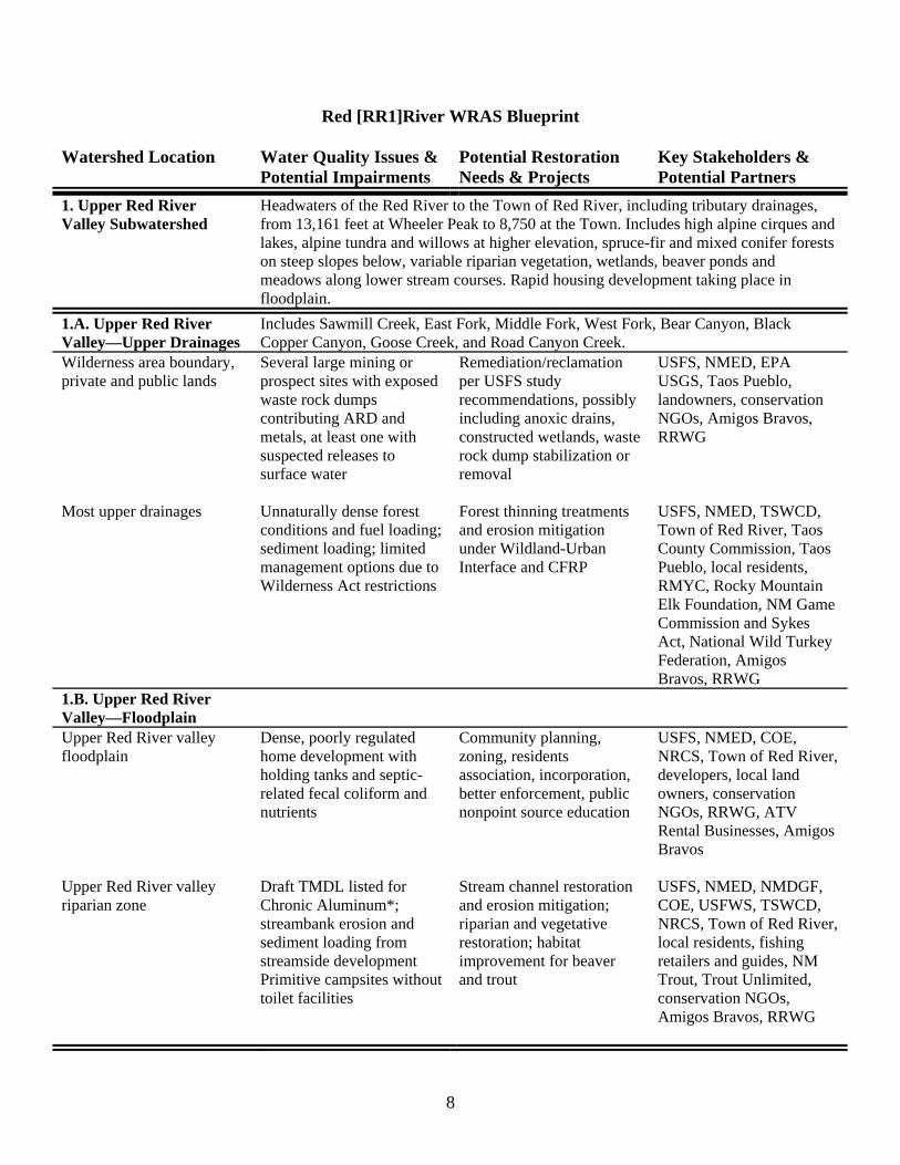
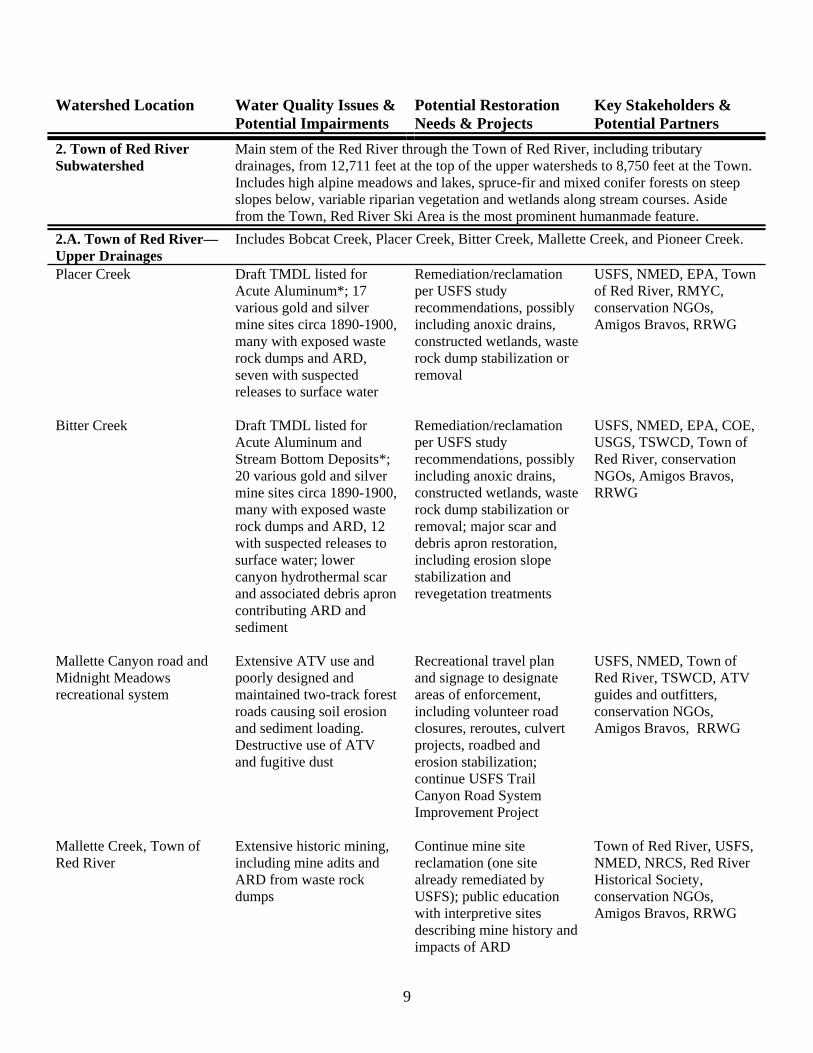
Red [RR1]River WRAS Blueprint
Watershed Location Water Quality Issues & Potential Impairments
Potential Restoration Needs & Projects
Key Stakeholders & Potential Partners
1. Upper Red River Valley Subwatershed
Headwaters of the Red River to the Town of Red River, including tributary drainages, from 13,161 feet at Wheeler Peak to 8,750 at the Town. Includes high alpine cirques and lakes, alpine tundra and willows at higher elevation, spruce-fir and mixed conifer forests on steep slopes below, variable riparian vegetation, wetlands, beaver ponds and meadows along lower stream courses. Rapid housing development taking place in floodplain.
1.A. Upper Red River Valley—Upper Drainages
Includes Sawmill Creek, East Fork, Middle Fork, West Fork, Bear Canyon, Black Copper Canyon, Goose Creek, and Road Canyon Creek.
Wilderness area boundary, private and public lands
Several large mining or prospect sites with exposed waste rock dumps contributing ARD and metals, at least one with suspected releases to surface water
Remediation/reclamation per USFS study recommendations, possibly including anoxic drains, constructed wetlands, waste rock dump stabilization or removal
USFS, NMED, EPA USGS, Taos Pueblo, landowners, conservation NGOs, Amigos Bravos, RRWG
Most upper drainages Unnaturally dense forest
conditions and fuel loading; sediment loading; limited management options due to Wilderness Act restrictions
Forest thinning treatments and erosion mitigation under Wildland-Urban Interface and CFRP
USFS, NMED, TSWCD, Town of Red River, Taos County Commission, Taos Pueblo, local residents, RMYC, Rocky Mountain Elk Foundation, NM Game Commission and Sykes Act, National Wild Turkey Federation, Amigos Bravos, RRWG
1.B. Upper Red River Valley—Floodplain
Upper Red River valley floodplain
Dense, poorly regulated home development with holding tanks and septic-related fecal coliform and nutrients
Community planning, zoning, residents association, incorporation, better enforcement, public nonpoint source education
USFS, NMED, COE, NRCS, Town of Red River, developers, local land owners, conservation NGOs, RRWG, ATV Rental Businesses, Amigos Bravos
Upper Red River valley riparian zone
Draft TMDL listed for Chronic Aluminum*; streambank erosion and sediment loading from streamside development Primitive campsites without toilet facilities
Stream channel restoration and erosion mitigation; riparian and vegetative restoration; habitat improvement for beaver and trout
USFS, NMED, NMDGF, COE, USFWS, TSWCD, NRCS, Town of Red River, local residents, fishing retailers and guides, NM Trout, Trout Unlimited, conservation NGOs, Amigos Bravos, RRWG
8
Watershed Location Water Quality Issues & Potential Impairments
Potential Restoration Needs & Projects
Key Stakeholders & Potential Partners
2. Town of Red River Subwatershed
Main stem of the Red River through the Town of Red River, including tributary drainages, from 12,711 feet at the top of the upper watersheds to 8,750 feet at the Town. Includes high alpine meadows and lakes, spruce-fir and mixed conifer forests on steep slopes below, variable riparian vegetation and wetlands along stream courses. Aside from the Town, Red River Ski Area is the most prominent humanmade feature.
2.A. Town of Red River—Upper Drainages
Includes Bobcat Creek, Placer Creek, Bitter Creek, Mallette Creek, and Pioneer Creek.
Placer Creek Draft TMDL listed for Acute Aluminum*; 17 various gold and silver mine sites circa 1890-1900, many with exposed waste rock dumps and ARD, seven with suspected releases to surface water
Remediation/reclamation per USFS study recommendations, possibly including anoxic drains, constructed wetlands, waste rock dump stabilization or removal
USFS, NMED, EPA, Town of Red River, RMYC, conservation NGOs, Amigos Bravos, RRWG
Bitter Creek Draft TMDL listed for
Acute Aluminum and Stream Bottom Deposits*; 20 various gold and silver mine sites circa 1890-1900, many with exposed waste rock dumps and ARD, 12 with suspected releases to surface water; lower canyon hydrothermal scar and associated debris apron contributing ARD and sediment
Remediation/reclamation per USFS study recommendations, possibly including anoxic drains, constructed wetlands, waste rock dump stabilization or removal; major scar and debris apron restoration, including erosion slope stabilization and revegetation treatments
USFS, NMED, EPA, COE, USGS, TSWCD, Town of Red River, conservation NGOs, Amigos Bravos, RRWG
Mallette Canyon road and Midnight Meadows recreational system
Extensive ATV use and poorly designed and maintained two-track forest roads causing soil erosion and sediment loading. Destructive use of ATV and fugitive dust
Recreational travel plan and signage to designate areas of enforcement, including volunteer road closures, reroutes, culvert projects, roadbed and erosion stabilization; continue USFS Trail Canyon Road System Improvement Project
USFS, NMED, Town of Red River, TSWCD, ATV guides and outfitters, conservation NGOs, Amigos Bravos, RRWG
Mallette Creek, Town of Red River
Extensive historic mining, including mine adits and ARD from waste rock dumps
Continue mine site reclamation (one site already remediated by USFS); public education with interpretive sites describing mine history and impacts of ARD
Town of Red River, USFS, NMED, NRCS, Red River Historical Society, conservation NGOs, Amigos Bravos, RRWG
9
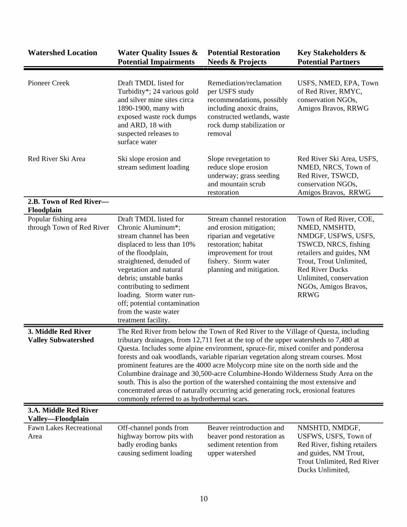
Watershed Location Water Quality Issues & Potential Impairments
Potential Restoration Needs & Projects
Key Stakeholders & Potential Partners
Pioneer Creek Draft TMDL listed for
Turbidity*; 24 various gold and silver mine sites circa 1890-1900, many with exposed waste rock dumps and ARD, 18 with suspected releases to surface water
Remediation/reclamation per USFS study recommendations, possibly including anoxic drains, constructed wetlands, waste rock dump stabilization or removal
USFS, NMED, EPA, Town of Red River, RMYC, conservation NGOs, Amigos Bravos, RRWG
Red River Ski Area Ski slope erosion and
stream sediment loading Slope revegetation to reduce slope erosion underway; grass seeding and mountain scrub restoration
Red River Ski Area, USFS, NMED, NRCS, Town of Red River, TSWCD, conservation NGOs, Amigos Bravos, RRWG
2.B. Town of Red River—Floodplain
Popular fishing area through Town of Red River
Draft TMDL listed for Chronic Aluminum*; stream channel has been displaced to less than 10% of the floodplain, straightened, denuded of vegetation and natural debris; unstable banks contributing to sediment loading. Storm water run-off; potential contamination from the waste water treatment facility.
Stream channel restoration and erosion mitigation; riparian and vegetative restoration; habitat improvement for trout fishery. Storm water planning and mitigation.
Town of Red River, COE, NMED, NMSHTD, NMDGF, USFWS, USFS, TSWCD, NRCS, fishing retailers and guides, NM Trout, Trout Unlimited, Red River Ducks Unlimited, conservation NGOs, Amigos Bravos, RRWG
3. Middle Red River Valley Subwatershed
The Red River from below the Town of Red River to the Village of Questa, including tributary drainages, from 12,711 feet at the top of the upper watersheds to 7,480 at Questa. Includes some alpine environment, spruce-fir, mixed conifer and ponderosa forests and oak woodlands, variable riparian vegetation along stream courses. Most prominent features are the 4000 acre Molycorp mine site on the north side and the Columbine drainage and 30,500-acre Columbine-Hondo Wilderness Study Area on the south. This is also the portion of the watershed containing the most extensive and concentrated areas of naturally occurring acid generating rock, erosional features commonly referred to as hydrothermal scars.
3.A. Middle Red River Valley—Floodplain
Fawn Lakes Recreational Area
Off-channel ponds from highway borrow pits with badly eroding banks causing sediment loading
Beaver reintroduction and beaver pond restoration as sediment retention from upper watershed
NMSHTD, NMDGF, USFWS, USFS, Town of Red River, fishing retailers and guides, NM Trout, Trout Unlimited, Red River Ducks Unlimited,
10
Watershed Location Water Quality Issues & Potential Impairments
Potential Restoration Needs & Projects
Key Stakeholders & Potential Partners conservation NGOs, Amigos Bravos, RRWG
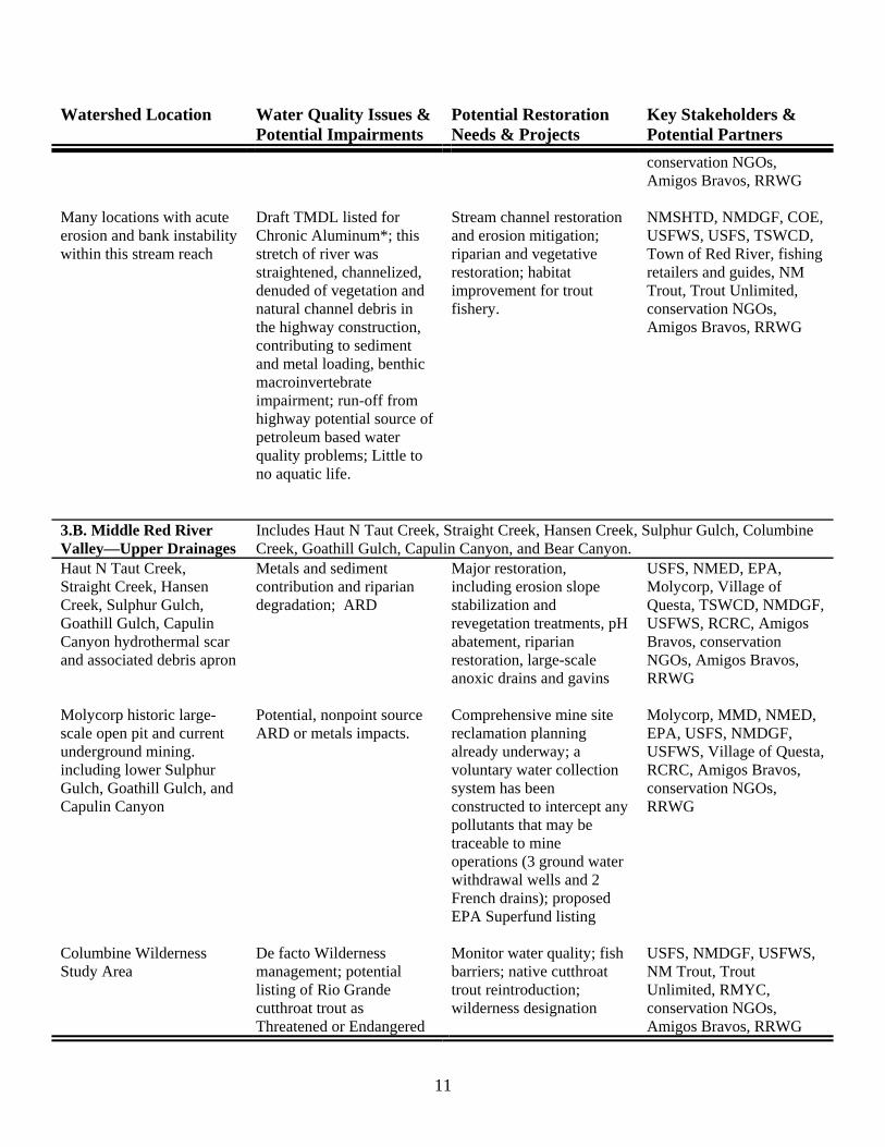
Many locations with acute erosion and bank instability within this stream reach
Draft TMDL listed for Chronic Aluminum*; this stretch of river was straightened, channelized, denuded of vegetation and natural channel debris in the highway construction, contributing to sediment and metal loading, benthic macroinvertebrate impairment; run-off from highway potential source of petroleum based water quality problems; Little to no aquatic life.
Stream channel restoration and erosion mitigation; riparian and vegetative restoration; habitat improvement for trout fishery.
NMSHTD, NMDGF, COE, USFWS, USFS, TSWCD, Town of Red River, fishing retailers and guides, NM Trout, Trout Unlimited, conservation NGOs, Amigos Bravos, RRWG
3.B. Middle Red River Valley—Upper Drainages
Includes Haut N Taut Creek, Straight Creek, Hansen Creek, Sulphur Gulch, Columbine Creek, Goathill Gulch, Capulin Canyon, and Bear Canyon.
Haut N Taut Creek, Straight Creek, Hansen Creek, Sulphur Gulch, Goathill Gulch, Capulin Canyon hydrothermal scar and associated debris apron
Metals and sediment contribution and riparian degradation; ARD
Major restoration, including erosion slope stabilization and revegetation treatments, pH abatement, riparian restoration, large-scale anoxic drains and gavins
USFS, NMED, EPA, Molycorp, Village of Questa, TSWCD, NMDGF, USFWS, RCRC, Amigos Bravos, conservation NGOs, Amigos Bravos, RRWG
Molycorp historic large-scale open pit and current underground mining. including lower Sulphur Gulch, Goathill Gulch, and Capulin Canyon
Potential, nonpoint source ARD or metals impacts.
Comprehensive mine site reclamation planning already underway; a voluntary water collection system has been constructed to intercept any pollutants that may be traceable to mine operations (3 ground water withdrawal wells and 2 French drains); proposed EPA Superfund listing
Molycorp, MMD, NMED, EPA, USFS, NMDGF, USFWS, Village of Questa, RCRC, Amigos Bravos, conservation NGOs, RRWG
Columbine Wilderness Study Area
De facto Wilderness management; potential listing of Rio Grande cutthroat trout as Threatened or Endangered
Monitor water quality; fish barriers; native cutthroat trout reintroduction; wilderness designation
USFS, NMDGF, USFWS, NM Trout, Trout Unlimited, RMYC, conservation NGOs, Amigos Bravos, RRWG
11
Watershed Location Water Quality Issues & Potential Impairments
Potential Restoration Needs & Projects
Key Stakeholders & Potential Partners
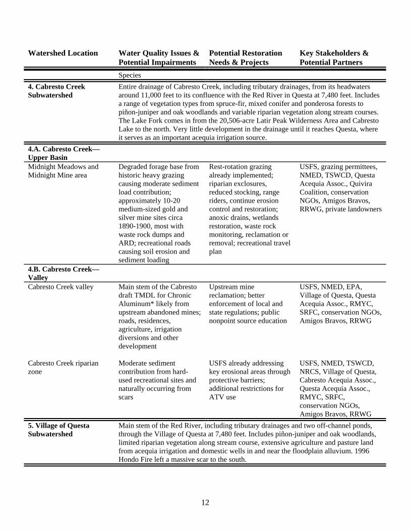
Species 4. Cabresto Creek Subwatershed
Entire drainage of Cabresto Creek, including tributary drainages, from its headwaters around 11,000 feet to its confluence with the Red River in Questa at 7,480 feet. Includes a range of vegetation types from spruce-fir, mixed conifer and ponderosa forests to piñon-juniper and oak woodlands and variable riparian vegetation along stream courses. The Lake Fork comes in from the 20,506-acre Latir Peak Wilderness Area and Cabresto Lake to the north. Very little development in the drainage until it reaches Questa, where it serves as an important acequia irrigation source.
4.A. Cabresto Creek—Upper Basin
Midnight Meadows and Midnight Mine area
Degraded forage base from historic heavy grazing causing moderate sediment load contribution; approximately 10-20 medium-sized gold and silver mine sites circa 1890-1900, most with waste rock dumps and ARD; recreational roads causing soil erosion and sediment loading
Rest-rotation grazing already implemented; riparian exclosures, reduced stocking, range riders, continue erosion control and restoration; anoxic drains, wetlands restoration, waste rock monitoring, reclamation or removal; recreational travel plan
USFS, grazing permittees, NMED, TSWCD, Questa Acequia Assoc., Quivira Coalition, conservation NGOs, Amigos Bravos, RRWG, private landowners
4.B. Cabresto Creek—Valley
Cabresto Creek valley Main stem of the Cabresto draft TMDL for Chronic Aluminum* likely from upstream abandoned mines; roads, residences, agriculture, irrigation diversions and other development
Upstream mine reclamation; better enforcement of local and state regulations; public nonpoint source education
USFS, NMED, EPA, Village of Questa, Questa Acequia Assoc., RMYC, SRFC, conservation NGOs, Amigos Bravos, RRWG
Cabresto Creek riparian zone
Moderate sediment contribution from hard-used recreational sites and naturally occurring from scars
USFS already addressing key erosional areas through protective barriers; additional restrictions for ATV use
USFS, NMED, TSWCD, NRCS, Village of Questa, Cabresto Acequia Assoc., Questa Acequia Assoc., RMYC, SRFC, conservation NGOs, Amigos Bravos, RRWG
5. Village of Questa Subwatershed
Main stem of the Red River, including tributary drainages and two off-channel ponds, through the Village of Questa at 7,480 feet. Includes piñon-juniper and oak woodlands, limited riparian vegetation along stream course, extensive agriculture and pasture land from acequia irrigation and domestic wells in and near the floodplain alluvium. 1996 Hondo Fire left a massive scar to the south.
12
Watershed Location Water Quality Issues & Potential Impairments
Potential Restoration Needs & Projects
Key Stakeholders & Potential Partners
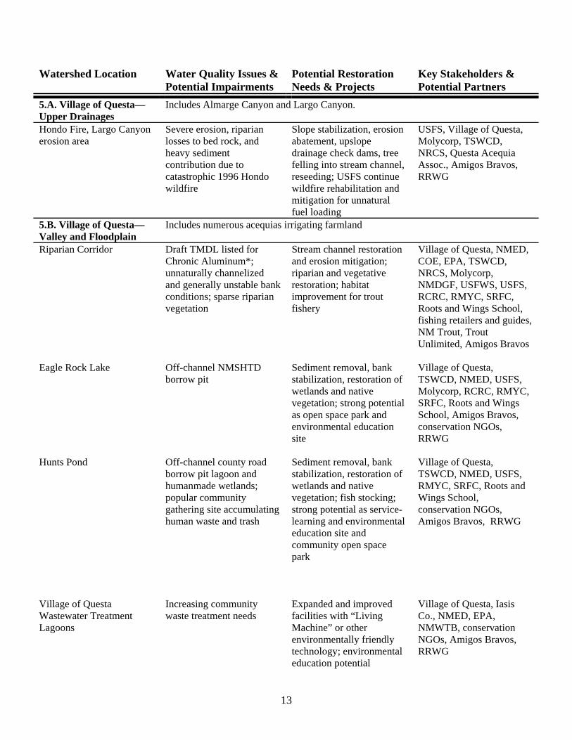
5.A. Village of Questa—Upper Drainages
Includes Almarge Canyon and Largo Canyon.
Hondo Fire, Largo Canyon erosion area
Severe erosion, riparian losses to bed rock, and heavy sediment contribution due to catastrophic 1996 Hondo wildfire
Slope stabilization, erosion abatement, upslope drainage check dams, tree felling into stream channel, reseeding; USFS continue wildfire rehabilitation and mitigation for unnatural fuel loading
USFS, Village of Questa, Molycorp, TSWCD, NRCS, Questa Acequia Assoc., Amigos Bravos, RRWG
5.B. Village of Questa—Valley and Floodplain
Includes numerous acequias irrigating farmland
Riparian Corridor Draft TMDL listed for Chronic Aluminum*; unnaturally channelized and generally unstable bank conditions; sparse riparian vegetation
Stream channel restoration and erosion mitigation; riparian and vegetative restoration; habitat improvement for trout fishery
Village of Questa, NMED, COE, EPA, TSWCD, NRCS, Molycorp, NMDGF, USFWS, USFS, RCRC, RMYC, SRFC, Roots and Wings School, fishing retailers and guides, NM Trout, Trout Unlimited, Amigos Bravos
Eagle Rock Lake Off-channel NMSHTD
borrow pit Sediment removal, bank stabilization, restoration of wetlands and native vegetation; strong potential as open space park and environmental education site
Village of Questa, TSWCD, NMED, USFS, Molycorp, RCRC, RMYC, SRFC, Roots and Wings School, Amigos Bravos, conservation NGOs, RRWG
Hunts Pond Off-channel county road
borrow pit lagoon and humanmade wetlands; popular community gathering site accumulating human waste and trash
Sediment removal, bank stabilization, restoration of wetlands and native vegetation; fish stocking; strong potential as service-learning and environmental education site and community open space park
Village of Questa, TSWCD, NMED, USFS, RMYC, SRFC, Roots and Wings School, conservation NGOs, Amigos Bravos, RRWG
Village of Questa Wastewater Treatment Lagoons
Increasing community waste treatment needs
Expanded and improved facilities with “Living Machine” or other environmentally friendly technology; environmental education potential
Village of Questa, Iasis Co., NMED, EPA, NMWTB, conservation NGOs, Amigos Bravos, RRWG
13
Watershed Location Water Quality Issues & Potential Impairments
Potential Restoration Needs & Projects
Key Stakeholders & Potential Partners
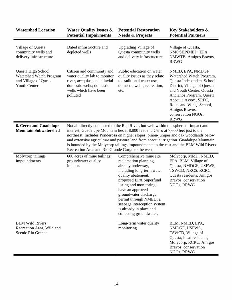
Village of Questa community wells and delivery infrastructure
Dated infrastructure and depleted wells
Upgrading Village of Questa community wells and delivery infrastructure
Village of Questa, NMOSE,NMED, EPA, NMWTB, Amigos Bravos, RRWG
Questa High School Watershed Watch Program and Village of Questa Youth Center
Citizen and community and water quality lab to monitor river, acequias, and alluvial domestic wells; domestic wells which have been polluted
Public education on water quality issues as they relate to traditional water use, domestic wells, recreation, etc.
NMED, EPA, NMDGF Watershed Watch Program, Questa Independent School District, Village of Questa and Youth Center, Questa Ancianos Program, Questa Acequia Assoc., SRFC, Roots and Wings School, Amigos Bravos, conservation NGOs, RRWG
6. Cerro and Guadalupe Mountain Subwatershed
Not all directly connected to the Red River, but well within the sphere of impact and interest, Guadalupe Mountain lies at 8,800 feet and Cerro at 7,600 feet just to the northeast. Includes Ponderosa on higher slopes, piñon-juniper and oak woodlands below and extensive agriculture and pasture land from acequia irrigation. Guadalupe Mountain is bounded by the Molycorp tailings impoundments to the east and the BLM Wild Rivers Recreation Area and Rio Grande Gorge to the west.
Molycorp tailings impoundments
600 acres of mine tailings; groundwater quality impacts
Comprehensive mine site reclamation planning already underway, including long-term water quality abatement; proposed EPA Superfund listing and monitoring; have an approved groundwater discharge permit through NMED; a seepage interception system is already in place and collecting groundwater.
Molycorp, MMD, NMED, EPA, BLM, Village of Questa, NMDGF, USFWS, TSWCD, NRCS, RCRC, Questa residents, Amigos Bravos, conservation NGOs, RRWG
BLM Wild Rivers Recreation Area, Wild and Scenic Rio Grande
Long-term water quality monitoring
BLM, NMED, EPA, NMDGF, USFWS, TSWCD, Village of Questa, local residents, Molycorp, RCRC, Amigos Bravos, conservation NGOs, RRWG
14
Watershed Location Water Quality Issues & Potential Impairments
Potential Restoration Needs & Projects
Key Stakeholders & Potential Partners
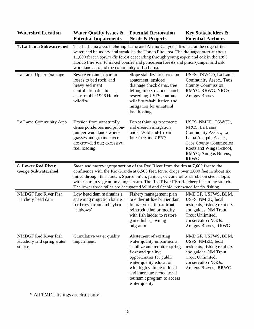
7. La Lama Subwatershed The La Lama area, including Lama and Alamo Canyons, lies just at the edge of the watershed boundary and straddles the Hondo Fire area. The drainages start at about 11,600 feet in spruce-fir forest descending through young aspen and oak in the 1996 Hondo Fire scar to mixed conifer and ponderosa forests and piñon-juniper and oak woodlands around the community of La Lama.
La Lama Upper Drainage Severe erosion, riparian losses to bed rock, and heavy sediment contribution due to catastrophic 1996 Hondo wildfire
Slope stabilization, erosion abatement, upslope drainage check dams, tree felling into stream channel, reseeding; USFS continue wildfire rehabilitation and mitigation for unnatural fuel loading
USFS, TSWCD, La Lama Community Assoc., Taos County Commission RMYC, RRWG, NRCS, Amigos Bravos
La Lama Community Area Erosion from unnaturally
dense ponderosa and piñon-juniper woodlands where grasses and groundcover are crowded out; excessive fuel loading
Forest thinning treatments and erosion mitigation under Wildland-Urban Interface and CFRP
USFS, NMED, TSWCD, NRCS, La Lama Community Assoc., La Lama Acequia Assoc., Taos County Commission Roots and Wings School, RMYC, Amigos Bravos, RRWG
8. Lower Red River Gorge Subwatershed
Steep and narrow gorge section of the Red River from the rim at 7,600 feet to the confluence with the Rio Grande at 6,500 feet. River drops over 1,000 feet in about six miles through this stretch. Sparse piñon, juniper, oak and other shrubs on steep slopes with riparian vegetation along stream. The Red River Fish Hatchery lies in the stretch. The lower three miles are designated Wild and Scenic, renowned for fly fishing.
NMDGF Red River Fish Hatchery head dam
Low head dam maintains a spawning migration barrier for brown trout and hybrid “cutbows”
Fishery management plan to either utilize barrier dam for native cutthroat trout reintroduction or modify with fish ladder to restore game fish spawning migration
NMDGF, USFWS, BLM, USFS, NMED, local residents, fishing retailers and guides, NM Trout, Trout Unlimited, conservation NGOs, Amigos Bravos, RRWG
NMDGF Red River Fish Hatchery and spring water source
Cumulative water quality impairments.
Abatement of existing water quality impairments; stabilize and monitor spring flow and quality; opportunities for public water quality education with high volume of local and interstate recreational tourism ; program to access water quality
NMDGF, USFWS, BLM, USFS, NMED, local residents, fishing retailers and guides, NM Trout, Trout Unlimited, conservation NGOs, Amigos Bravos, RRWG
* All TMDL listings are draft only.
15
Glossary of abbreviations ARD Acid Rock Drainage generated by unreclaimed mine waste rock dumps and tailings BLM U.S. Bureau of Land Management CFRP Collaborative Forest Restoration Program COE U.S. Army Corps of Engineers EPA U.S. Environmental Protection Agency MMD New Mexico Mining & Minerals Division NGO Non-Governmental Organization NMDGF New Mexico Department of Game & Fish NMED New Mexico Environment Department NMOSE New Mexico Office of the State Engineer NMSHTD New Mexico State Highway & Transportation Department NMWTB New Mexico Water Trust Board NPDES National Pollutant Discharge Elimination System NRCS U.S. Natural Resources Conservation Service (formerly Soil Conservation Service) RCRC Río Colorado Reclamation Committee RMYC Rocky Mountain Youth Corps RRWG Red River Watershed Group SRFC Singing River Field Center TSWCD Taos Soil & Water Conservation District USFS U.S. Forest Service USFWS U.S. Fish & Wildlife Service
16
IV. Water Quality Goals Desired Conditions and Uses One priority water quality goal is to implement the proposed TMDLs for the Red River and its tributaries in as far as we are able throughout the watershed. Remediating chronic and acute aluminum stream bottom deposits and turbidity contamination might be beyond the reach and capacity of the Red River Watershed Group. As the WRAS continues to evolve through an iterative, adaptive process, Watershed Group partners and working groups will determine specific desired uses and the conditions required to reach those uses for each subwatershed and/or on a project-by-project basis. This process will involve the land management and regulatory agencies, but will also involve watershed residents and other stakeholder through an extensive outreach program. To help determine desired uses and conditions we will solicit local perspectives, values, and priorities through local advisory committees, public meetings, questionnaires, targeted interviews, and/or focus groups. The scoping, designing, and implementation of projects will obviously incorporate all available information and will also utilize the best science available. Monitoring and Assessments To measure whether we have attained the desired uses and conditions, it will be important to establish clear water quality goals and monitoring protocols for each restoration project. Along with conventional quantitative water quality measurements, in places we will also utilize the Rosgen Stream Classification System for general assessments of stream health and fishery habitat, as well as other qualitative ecological assessments as appropriate. Whenever possible, we will utilize all available regulatory-related water quality monitoring data, both as existing baseline data and to monitor ongoing progress. Some of the baseline data will come from the draft TMDL background monitoring and other previous water quality studies and reports. However, all up-to-date and available data will be utilized. Particular projects may be able to piggyback on the monitoring and data from the ongoing USGS Background Characterization Study, the RI/FS, and other Molycorp studies. As Watershed Group partners, the regulatory agencies, Molycorp, and the Town of Red River water quality lab might contribute not only data, but technical assistance and expertise. In addition to existing partners, we may find need to hire professional consultants to help design and implement water quality monitoring and other assessments. Water quality monitoring and other assessments, before, during, and after each project, can double as an excellent opportunity for hands-on education. Through the state-sponsored Watershed Watch, the Questa High School science program already has an active water quality monitoring program in place. Roots and Wings Community School in Lama, Rocky Mountain Youth Corps, non-profit community and environmental organizations, and the general public can all participate in monitoring and assessments. This approach opens many opportunities for expanded outreach, solicits in-kind contributions to help get the work done, and provides solid experiential education for the participants.
17
Project and Process Evaluation In addition to physical monitoring and assessments, it is just as important to monitor and evaluate the process of communication, collaborative planning, and project implementation on an ongoing basis. The Watershed Group will actively solicit and incorporate recommendations and input from all project partners and local residents early in the planning process. During and after every project, we will actively solicit and incorporate follow-up recommendations and input as part of an iterative adaptive management process. This is important for better project implementation, but also for improving communications, strengthening collaborative partnerships, and working toward building a broad and strong watershed-wide community.
18
V. Action Plan Still a Collaborative and Comprehensive Approach A WRAS, by definition and intent, is a comprehensive approach that includes technical, educational, and financial components of watershed restoration. The Red River Watershed Group was originally founded to take on the significant water quality problems within the watershed in just such a comprehensive way—step by step, project by project. We take the next major step in that process with this WRAS. The Watershed Group may not take the lead on every project, but a main function will be to coordinate all the relevant stakeholders, information, technical resources, public educational activities, and finances for watershed restoration projects. With all projects, the Watershed Group will help coordinate compliance with all laws, regulations, and permits, particularly the legal requirements of NEPA and other federal laws for any actions on federal lands. This coordinated approach will help facilitate communication, networking, and planning among the many agency and private stakeholders, even beyond the scope of the WRAS, and will help avoid duplication of efforts. The table in Chapter III includes a preliminary list of key stakeholders and potential partners for each potential project area. As part of the project coordination, the Watershed Group will continue to identify and involve core stakeholders for each water quality issue or restoration project, incorporating existing mandates and agreements between agencies and other entities as much as possible. As with monitoring and assessments, involving and coordinating local schools and educational and non-profit conservation organizations in restoration projects will be an integral part of our effort. Again, it is an excellent opportunity to both enlist volunteers and facilitate hands-on watershed and natural resource education. The Watershed Group will always keep in mind the fact that this WRAS is a non-regulatory, voluntary approach based not on legal obligations but on the strength of collegial collaboration, open communication, and building a watershed community. It is important for us to keep that spirit in all our restoration planning and projects. Without a formal legal framework, however, we will structure strategic partnerships and stipulate expectations between agencies and other stakeholders through formal Memoranda of Understanding (MOUs) or Memoranda of Agreement (MOAs) to insure better follow through on restoration plans and projects. Some general MOUs and MOAs already exist between federal and state agencies. Priorities and Timetable Looking at the general list of water quality issues and potential problems and the potential restoration needs and projects on the table in Chapter III, it is obvious that there is no shortage of restoration work in this watershed. The trick will be to strategically prioritize the projects in a way that makes sense and is achievable. We will use several criteria for determining priorities and structuring projects: • Priority nonpoint source issues identified in the Draft Red River TMDL. Various areas
throughout the watershed have draft TMDLs proposed for Chronic and Acute Aluminum Stream Bottom Deposits, and Turbidity.
19
• Consistency with existing management plans. This might include, for instance, USFS forest thinning projects, erosion mitigation projects, grazing program modifications, or a recreation travel plan. The Village of Questa’s recent Comprehensive Plan calls for such things as better land use planning, protecting local water and land, preserving open space, and developing economic opportunities, all of which could well be consistent with restoration projects.
• Fit within existing MOUs and MOAs. Several state and federal agencies already have formal agreements and relationships through MOUs and MOAs that deal with particular issues.
• Reflect local community concerns and priorities. The Watershed Group has already started addressing septic contamination in the upper valley, for instance, due to local residents’ concerns.
• Potential as experimental pilot projects to test the feasibility of certain treatments. Before taking on a larger project with uncertain results, we will test certain treatments on a smaller scale first.
• Potential as demonstration pilot projects to generate public interest, involvement, and support. As one example, the Watershed Group has been instrumental in advancing the Hunt’s Pond project in Questa, which will not yield major water quality improvements to the river, but will be a high visibility project in an area with significant community interest and use. The project was chosen and designed with community input, and we expect plenty of local involvement in hands-on restoration work, monitoring, and public educational activities.
• Potential for building or strengthening partnerships. Along the lines of the previous item, building and strengthening relationships among watershed residents and stakeholders is a high priority to keep the WRAS process moving forward.
• Availability of funding. All projects will of course be contingent on funding. The table in Chapter III outlines water quality issues and potential restoration projects on a site-by-site basis. In general, the Watershed Group will address identified quality issues (from the list under “Water Quality Problems” in Chapter III) in the following ways: • Unnaturally dense forest conditions and excessive fuel loading in spruce-fir and mixed
conifer areas from historical fire and forestry management practices. Work with the USFS and local residents to develop local expertise in thinning and prescribed fire programs through the Collaborative Forest Restoration Program (CFRP) and the Wildland-Urban Interface fire program. This will also create significant opportunities for local capacity building and sustainable, small-scale economic development.
• Acid rock drainage and mineralized sediment/metals loading from natural hydrothermal erosional scars. Experiment first on small-scale debris-flow mitigation treatments and identify specific problem tributaries for large-scale treatment.
• Sediment and nutrient contamination from excessive livestock and wildlife grazing. Conduct impact assessment and mitigation, including the USFS’s ongoing implementation of rest-rotation grazing management and erosions control.
• Acid rock drainage and metals contamination from abandoned historic mines. Following the recommendations from the completed USFS abandoned mine inventory and assessment, implement a variety of reclamation and remediation projects, possibly including full-scale mine reclamation, anoxic drains, and constructed wetlands development.
20
• Nutrient contamination from poorly designed and poorly regulated septic systems in the upper valley floodplain. Continue the process of citizen monitoring, public education, and regulatory enforcement of Taos County and NMED regulations.
• Wetlands, riparian, and stream impacts from dense and poorly regulated development in the upper valley. Continue the process of public education, citizen monitoring, and regulatory enforcement of U.S. Army Corps of Engineers permits and regulations.
• Sediment erosion from excessive ATV use and poorly designed and maintained recreational roads. Building upon the ongoing USFS recreational road inventory and assessment, prepare a comprehensive recreational travel plan with all stakeholders, possibly including volunteer road closures, reroutes, culvert projects, and roadbed and erosion stabilization.
• Erosion from unnaturally dense ponderosa and piñon-juniper woodlands where grasses and groundcover are crowded out. Work with the USFS and local residents to develop local expertise in thinning and prescribed fire programs through the CFRP and the Wildland-Urban Interface fire program, and reseed native grasses. This will also create opportunities for small-scale fuelwood enterprises.
• Sediment erosion from road cuts along State Highway 38 and other paved roads. Working with the New Mexico State Highway & Transportation Department and NMED, conduct an impact assessment and design mitigation projects.
• Unregulated mineralized groundwater seeps into Red River. Identify mineralized groundwater seeps that are not currently regulated conduct impact assessments, and design remediation projects.
• Severe erosion from Hondo Fire scar. Coordinate local youth, volunteer, and non-profit conservation organizations to help continue USFS’s ongoing erosion control work.
• Habitat loss due to degraded and unnaturally channelized stream course. Conduct stream morphology assessments and enhancements based on Dave Rosgen’s Stream Classification System.
A specific timetable for restoration work will emerge as the WRAS process moves forward and projects are prioritized as described above and get started. Depending on which of the many projects we choose to tackle first, our ability to coordinate and schedule with agencies and other stakeholders, and contingent on the availability of funding, we hope to be underway with at least one or two demonstration 319 nonpoint source projects by next year. Given the range, variety, and scale of water quality issues in the Red River watershed, however, comprehensive WRAS implementation will be an open-ended process likely to last indefinitely.
21
VI. Funding and Coordination Red River Watershed Group Structure As the main vehicle for facilitating and coordinating WRAS implementation, as described in previous chapters, the Red River Watershed Group will consider officially incorporating and seeking 501(c)(3) non-profit tax status. Among other benefits, this will create a more formalized and accountable structure, including, at a minimum, a board of directors and operating bylaws. It will also increase the group’s credibility and open the possibility of applying directly for grants. As part of the process of formalizing the structure, it might become necessary for the group to hire a full-time coordinator or director, and possibly other staff and/or contractors, to oversee all the outreach, coordination, project implementation, fundraising, and other activities that could be undertaken under this WRAS. Formal structure might include working committees on a variety of issues, a community advisory council, project committees, or any number of other mechanisms to insure stakeholder involvement in decision making and accountability to watershed residents and a Watershed Group partners. Funding One of the Watershed Group’s main coordinating functions is to secure and coordinate appropriate funding to match up with particular restoration projects and key stakeholders. In some cases where funding is already in place or accessible with a particular Watershed Group partner, we may simply help coordinate the project and other partners around the funding. Matching funds are often required for federal or state grants and one of our coordinating functions with be secure and document in-kind contributions of materials, equipment, and labor from all participating partners, schools, non-profit conservation organizations, and the general public. Potential federal sources for watershed restoration funding include: • 319 nonpoint source grants from EPA • EPA watershed initiative grants • CFRP grants • U.S. Natural Resources Conservation Service assistance • USFS and possible Abandoned Hardrock Mines Restoration Act funding for abandoned mine
reclamation and ARD remediation Potential state and local sources for watershed restoration funding include: • New Mexico State Legislature • Taos Soil and Water Conservation District • Village of Questa • Town of Red River
22
In addition to government grants and assistance, there are numerous private foundations, both locally and nationally, the fund watershed-based restoration initiatives such as this WRAS, and we will also research and seek grants from those sources as needed.
23
Additional Information Partnership List (see the glossary of abbreviations at the end of this section)
A. Past participation with the Red River Watershed GroupAmigos Bravos BLM Molycorp MMD NMDGF NMDGF Watershed Watch NMED Questa residents Red River residents Rio Grande Restoration
RMYC SRFC Taos Pueblo Town of Red River Upper Valley residents USFS USFWS USGS Village of Questa Western Environmental Law Center
B. Current and potential jurisdictional partnersBLM Cabresto Acequia Association COE EPA La Lama Acequia Association MMD NM Game Commission and Sykes Act NM Governor Bill Richardson NM Representative Bobby Gonzales NM Senator Carlos Cisneros NMDGF NMDGF Watershed Watch NMED NMED NMSFD NMSHTD
NMWTB NRCS OSE Questa Acequia Association Taos County Commission Taos County Commissioner Virgil Martinez Taos Pueblo Town of Red River TSWCD U.S. Congressman Tom Udall U.S. Senator Jeff Bingaman U.S. Senator Pete Domenici USFS USFWS USGS Village of Questa
C. Current and potential citizen and NGO partnersAmigos Bravos Cabresto Acequia Association Cabresto Canyon residents La Lama residents Lama Foundation Molycorp National Wild Turkey Federation NM Trout Questa Acequia Association Questa residents
Questa Youth Center Red River Ducks Unlimited Red River residents Red River Rocky Mountain Corps Red River Ski Area RCRC Rio Grande Restoration RMYC Roots and Wings School SRFC
24
Taos Community Foundation Trout Unlimited UNM Oral History Program
Upper Valley residents Western Environmental Law Center
D. Current and potential partners with existing planning documentsAmigos Bravos BLM EPA Molycorp NMED NMSHTD Taos County Commission
Taos County Planning Department Taos Pueblo Town of Red River TSWCD USFS Village of Questa
Glossary of abbreviations BLM U.S. Bureau of Land Management COE U.S. Army Corps of Engineers EPA U.S. Environmental Protection Agency MMD New Mexico Mining & Minerals Division NGO Non-Governmental Organization NMDGF New Mexico Department of Game & Fish NMED New Mexico Environment Department NMSFD New Mexico State Forestry Division NMSHTD New Mexico State Highway & Transportation Department NMWTB New Mexico Water Trust Board NRCS U.S. Natural Resources Conservation Service (formerly Soil Conservation Service) OSE New Mexico Office of the State Engineer RCRC Río Colorado Reclamation Committee RMYC Rocky Mountain Youth Corps RRWG Red River Watershed Group SRFC Singing River Field Center TSWCD Taos Soil & Water Conservation District USFS U.S. Forest Service USFWS U.S. Fish & Wildlife Service
25
Directory of Government Agencies and Other Organizations Amigos Bravos, Friends of the Wild Rivers (non-profit advocacy group focusing on Molycorp issues) PO Box 238 Taos, NM 87513
(505) 758-3874 www.amigosbravos.org/molycorpwatch
Molycorp, Inc. (operates the Molycorp Mine and tailings impoundments near Questa) PO Box 469 Questa, NM 87556
(505) 586-0212 www.molycorp.com
New Mexico Department of Game and Fish (operates Red River Fish Hatchery and stocks river for fishing) PO Box 25112 Santa Fe, NM 87504
(505) 476-8000 www.wildlife.state.nm.us
New Mexico Environment Department (responsible for surface water, groundwater, and drinking water quality and permitting) PO Box 26110 Santa Fe, NM 87502 NMED Drinking Water Quality Bureau (community drinking water systems) NMED Groundwater Quality Bureau (groundwater discharge permits) NMED Surface Water Quality Bureau (319 program and TMDLs) NMED Taos Field Office (liquid waste permitting for septic systems) PO Box 208 Taos, NM 87571 (505) 758-8808
www.nmenv.state.nm.us (505) 827-0187 (505) 827-2919 (505) 827-7536
New Mexico Mining and Minerals Division (administers mining and reclamation permits) 1220 South St. Francis Dr. Santa Fe, NM 87505
(505) 476-3400 www.emnrd.state.nm.us/Mining
New Mexico Office of the State Engineer (administers all New Mexico water rights) PO Box 25102 (505) 827-6175 Santa Fe, NM 87504 www.seo.state.nm.us
26
Río Colorado Reclamation Committee (Technical Assistance Grant group disseminating technical information related to Superfund) P.O. Box 637 Questa, NM 87556
www.rcrc.nm.org
Taos Soil and Water Conservation District (education and services for local natural resources conservation) PO Box 2787 Ranchos de Taos, NM 87557
(505) 751-0584 email: [email protected]
U.S. Army Corps of Engineers (administers 404 permits for dredging or filling stream channels) 4001 Jefferson Plaza NE Albuquerque, NM 87109
(505) 342-3109 www.usace.army.mil
U.S. Bureau of Land Management, Taos Field Office (manages lower Red River and Río Grande Wild and Scenic Rivers area) 226 Cruz Alta Rd. Taos, NM 87571
(505) 758-8851 www.nm.blm.gov
U.S. Environmental Protection Agency (NPDES, and Superfund programs) 1445 Ross Ave., Suite 1200 Dallas, TX 75202
(214) 665-6444/(800) 887-6063 www.epa.gov
U.S. Forest Service, Carson National Forest (manages most of the headwater and streamside lands in the watershed) 208 Cruz Alta Rd. Taos, NM 87571
(505) 758-6200 www.fs.fed.us/r3/carson
USFS, Questa Ranger District (local ranger district the includes the Red River watershed) PO Box 110 Questa, NM 87556
(505) 586-0520
U.S. Geological Survey (streamflow and groundwater monitoring and mapping services) 5338 Montgomery NE, Suite 400 Albuquerque, NM 87109
(505) 830-7900/(888) 275-8747 www.usgs.gov
U.S. Natural Resources Conservation Service (conserves natural resources on private lands; formerly Soil Conservation Service) 224 Cruz Alta Rd. Taos, NM 87571
(505) 758-3701 www.nrcs.usda.gov
27
Glossary of Terms, Acronyms & Abbreviations 319 program—nonpoint source pollution prevention program under the Clean Water Act that provides grants and other assistance to local organizations and governments 404 permit—required under the Clean Water Act before dredging or filling stream channels or wetlands, administered by the U.S. Army Corps of Engineers ARD—Acid Rock Drainage generated by unreclaimed mine waste rock dumps and tailings BLM—U.S. Bureau of Land Management BMPs—Best Management Practices to reduce nonpoint source impacts CFRP—Collaborative Forest Restoration Program, which provides federal funding for community-based forest thinning and stewardship and small-diameter wood marketing COE—U.S. Army Corps of Engineers CWA—commonly known as the Clean Water Act, the 1972 Federal Water Pollution Control Act protects water quality in all streams, lakes, and other surface waters of the U.S., with a goal of eliminating the discharge of all pollutants EPA—U.S. Environmental Protection Agency GIS—Geographical Information System is a databased computer mapping technology that can generate multiple layers of different kinds of map information GWQB—Ground Water Quality Bureau of the New Mexico Environment Department MMD—Mining and Minerals Division of the New Mexico Energy, Minerals & Natural Resources Department MOA—Memorandum of Agreement MOU—Memorandum of Understanding NEPA—National Environmental Policy Act, which mandates an assessment of potential environmental consequences of management actions on federal public lands, possibly including Environmental Assessments or Environmental Impact Statements NGO—Non-Governmental Organization, generally a non-profit community or environmental organization NMDGF—New Mexico Department of Game & Fish NMED—New Mexico Environment Department NMEMNRD—New Mexico Energy, Minerals & Natural Resources Department NMMA—New Mexico Mining Act, which requires mine permitting and Closeout and Reclamation Plans NMSFD—New Mexico Forestry Division NMSHTD—New Mexico State Highway & Transportation Department NMWQA—New Mexico Water Quality Act, which mandates compliance with New Mexico water quality standards NMWTB—New Mexico Water Trust Board Nonpoint source—scattered, often indistinct pollution sources, such as abandoned mines, agricultural runoff, erosion from denuded hillsides or streambanks, fires scars, overgrazing or overcutting, parking lots, recreational or paved roads, etc. NPDES—National Pollutant Discharge Elimination System permit under the Clean Water Act requires compliance with water quality standards and TMDLs for point source discharges to surface water, administered by the Environmental Protection Agency NPS—Nonpoint source NRCS—U.S. Natural Resources Conservation Service (formerly the Soil Conservation Service)
28
OSE—New Mexico Office of the State Engineer Point source—any polluted effluent that flows into the river out of the end of a discharge pipe or from a distinct single source, such as runoff or seepage from an industrial site, usually regulated under NPDES permits RI/FS—Remedial Investigation and Feasibility Study is a preliminary step in the Superfund cleanup process RMYC—Rocky Mountain Youth Corps RRWG—Red River Watershed Group SRFC—Singing River Field Center Superfund—money and process administered by the Environmental Protection Agency to clean up toxic contamination that threatens environmental and human health SWQB—Surface Water Quality Bureau of the New Mexico Environment Department TAG—Technical Assistance Grant through the Environmental Protection Agency to assist local community interests in interpreting and disseminating technical information related to the Superfund process TMDL—Total Maximum Daily Loads set limits to particular substances identified as pollutants for any given stretch of river TSWCD—Taos Soil & Water Conservation District USDA—U.S. Department of Agriculture USDOI—U.S. Department of Interior USFS—U.S. Forest Service USFWS—U.S. Fish & Wildlife Service USGS—U.S. Geological Survey Watershed—the entire area of land, from the headwaters to the mouth of a drainage, that flows into a stream or water body Wildland-Urban Interface—federal program to reduce forest fire hazard on public lands around populated areas WRAS—Watershed Restoration Action Strategy is a non-regulatory, voluntary approach to addressing nonpoint source impacts to water quality
29
Bibliography and Other Resources All the material listed in this bibliography can be found in public and organizational libraries and at state and federal agencies. Using the following abbreviations and internet addresses where applicable, specific locations are included in parentheses following each entry. Location Codes AB Amigos Bravos Library, Taos BLM Bureau of Land Management, Taos Field Office CNF Carson National Forest Supervisor’s Office, Taos EPA Environmental Protection Agency, Region 6, Dallas, TX General General Library Access GWQB NMED Groundwater Quality Bureau, Santa Fe MMD New Mexico Mining and Minerals Division, Santa Fe NMDGF New Mexico Department of Game & Fish, Santa Fe NMSHTD New Mexico State Highway & Transportation Department, Santa Fe Questa Village of Questa Municipal Offices Repository RR Town of Red River SWQB NMED Surface Water Quality Bureau, Santa Fe TPL Taos Public Library UNM University of New Mexico Library Consortium, online at http://libros.unm.edu Land, Water & Management Akroyd, Robert F., Jr. 1988 Electroshocking Surveys of Red River. Memorandum to Michael Hatch. New Mexico
Department of Game & Fish. (NMDGF, AB) Atencio, Ernest 2000 The mine that turned the Red River blue: Activists turn the tables on the biggest,
slipperiest mine in the Rio Grande watershed. High Country News, August 28: pp. 1, 10-14. (General; www.hcn.org)
CDM Federal Programs Corporation 2000 Final Work Plan/Health and Safety Plan, Preliminary Assessment/Site Inspection,
Mallette Creek Watershed Abandoned/Inactive Mine Sites, Carson National Forest, New Mexico. Taos: U.S. Forest Service, November 27. (CNF)
2001 Final Preliminary Assessment/Site Inspection, Mallette Creek Watershed
Abandoned/Inactive Mine Sites, Carson National Forest, New Mexico. Taos: U.S. Forest Service, December 7. (CNF)
2002 Final Preliminary Assessment/Site Inspection, Hansen Creek Watershed
Abandoned/Inactive Mine Sites, Carson National Forest, New Mexico. Taos: U.S. Forest Service, July 8. (CNF)
30
Chadwick Ecological Consultants, Inc. 1997 Aquatic Biological Assessment of the Red River, New Mexico, in the vicinity of the
Questa Molybdenum Mine. Prepared for Molycorp, Inc., Questa New Mexico. Also Red River Aquatic Biological Monitoring, 1998 through 2000. (AB)
Daniel B. Stephens & Associates, Inc. 2002 Total Maximum Daily Load for Metals (Chronic and Acute Aluminum), Stream Bottom
Deposits, and Turbidity in Listed Reaches in the Red River Watershed. Albuquerque: New Mexico Environment Department. (AB)
ecology and environment, inc. 2001 Red River Headwaters, Carson National Forest, New Mexico. Preliminary
Assessment/Site Inspection. Taos: U.S. Forest Service, Region 3, September. (CNF) 2002a Pioneer Creek Watershed, Carson National Forest, New Mexico. Preliminary
Assessment/Site Inspection. Taos: U.S. Forest Service, Region 3, April. (CNF) 2002b Placer Creek Watershed, Carson National Forest, New Mexico. Preliminary
Assessment/Site Inspection. Taos: U.S. Forest Service, Region 3, April. (CNF) 2002c Bitter Creek Watershed, Carson National Forest, New Mexico. Preliminary
Assessment/Site Inspection. Taos: U.S. Forest Service, Region 3, May. (CNF) Gardiner, Ron G. 1996 The Red River Watershed: Planning and Users Guide. Paper prepared for UNM Water
Resources Administration Program. Courtesy of the author. (Questa) Garn, Herbert S. 1984 Spatial and Temporal Variations in Water Quality of the Rio Grande—Red River, Wild
and Scenic River, Taos County, New Mexico. Proceedings of a Symposium on Water Quality and Pollution in New Mexico, April 12, 1984. Socorro: New Mexico Bureau of Mines & Mineral Resources. (AB)
1985 Point and Nonpoint Source of Trace Elements in a Wild and Scenic River of Northern
New Mexico. Journal of Soil and Water Conservation, vol. 40, no. 5. (General) Garrabrant, Lynn A. 1993 Water Resources of Taos County, New Mexico. Prepared in cooperation with the New
Mexico State Engineer Office, New Mexico Environment Department, and New Mexico Bureau of Mines and Mineral Resources. Albuquerque: U.S. Department of Interior, U.S. Geological Survey. (UNM)
Gross, Michele Beth
31
1992 Aquatic Insects as Biomonitors for Heavy Metal Contamination in the Red River, Taos County, New Mexico. Master’s thesis, New Mexico Institute of Mining and Technology. (UNM)
Hagan, Laura Beth 2001 Natural and Mining-related Sources of Metal Contamination, Red River, Northwestern
New Mexico: a Hydrogeochemical Investigation of Surface Water and Groundwater. Master’s thesis, University of New Mexico, Department of Earth and Planetary Science. (UNM)
Jacobi, Gerald Z., et al. 1998 Benthic Macroinvertebrate Bioassessment of the Red River, New Mexico, USA. Paper
presented at the 27th Congress of the International Association of Theoretical and Applied Limnology, Dublin, Ireland. (AB)
Jacobi, Gerald Z. and Larry Smolka 1984 Intensive Survey of the Red River in the Vicinity of the Red River and Questa
Wastewater Treatment Facilities and the Molycorp Complex, Taos County, New Mexico. Santa Fe: Health & Environment Department. (AB)
Kline, Doyle 1974 My God—They’re Tearing the Mountain Down! Field & Stream, August: pp. 56-70.
(General) 1977 Killing of a Wild River. Field & Stream, September: pp. 104-110. (General) Lucius, Jeffrey E., et al.
2001 Results of Electrical Surveys near Red River, New Mexico. U.S. Geological Survey Open-File Report 01-0331. Electronic document: http://pubs.usgs.gov/of/2001/ofr-01-0331/index.html.
MacDonald, Lee, et al. 2002 Alternative: Restore and Manage Forests, Piñon-Juniper Woodlands, and Riparian
Systems. Alternative Assessment White Paper prepared for Jemez y Sangre Water Plan by Daniel B. Stephens & Associates, July. Courtesy of co-author Ernest Atencio.
Melancon, Susan M. S., et al. 1982 Site Specific Water Quality Assessment: Red River, New Mexico. Las Vegas, NV: U.S.
Environmental Protection Agency. (AB) Morain, Stan 1996 Landscape Change Survey, Red River Region, New Mexico: Aerial Photo
Interpretation of Federally Acquired Photographs Collected Between 1935/36 and 1992. (AB)
New Mexico Environment Department
32
1998 Clean Water Action Plan, Unified Watershed Assessment, New Mexico. Santa Fe: New Mexico Environment Department, September. (SWQB)
1999 New Mexico Nonpoint Source Management Program. Santa Fe: New Mexico
Environment Department, Surface Water Quality Bureau, NPS Pollution Section. (SWQB)
New Mexico Health and Environment Department 1989 Intensive Water Quality Survey of the Middle Red River, Taos County, New Mexico,
September 12-October 25, 1988. Santa Fe: Surface Water Quality Bureau, New Mexico Health and Environment Department. (AB)
New Mexico State Highway and Transportation Department 1992 Environmental Assessment Project 1529.11: Reconstruction of NM 38, Questa east for
4.9 miles. Santa Fe: Federal Highway Administration, New Mexico Division, and New Mexico State Highway and Transportation Department. (NMSHTD, UNM)
1995 Environmental Assessment Project TPM-TPE-0038(14) CN-2432: NM 38 improvement
project, Taos County, New Mexico. Santa Fe: the New Mexico State Highway and Transportation Department, in cooperation with the U.S. Department of Transportation, Federal Highway Administration, New Mexico Division. (NMSHTD, UNM)
New Mexico Water Pollution Control Bureau 1982 Point source waste load allocation for the town of Red River: milestone 6.2.b. Santa Fe:
Water Pollution Control Bureau, Environmental Improvement Division, New Mexico Health and Environment Department. (SWQB, UNM)
Nordstrom, D. K., et al. 2002 The Questa baseline and pre-mining ground-water quality investigation: preliminary
data [abs.]. Geological Society of America Abstracts with Programs, v.34, no. 6: p. 51. Electronic document: http://wwwbrr.cr.usgs.gov/projects/GWC_chemtherm/questa.htm.
2003 A baseline and pre-mining ground-water quality investigation at the Questa
molybdenum mine site, New Mexico, USA. [abs.]. 7th International Conference on the Biogeochemistry of Trace Elements, Uppsala, Sweden, June 15-19. Electronic document: http://wwwbrr.cr.usgs.gov/projects/GWC_chemtherm/questa.htm.
Rosgen, David L. 1996 Applied River Morphology. Pagosa Springs: Wildland Hydrology Books. (General,
UNM) 1998 Field Guide for Stream Classification. Pagosa Springs: Wildland Hydrology Books.
(General, UNM) Slifer, Dennis
33
1996 Red River Groundwater Investigation. Santa Fe: New Mexico Environment Department, Surface Water Quality Bureau. (SWQB, AB)
Smalling, Wes R. 1998 Red River. Rocky Mountain Edition, pp.18-21. (General) Smolka, Larry R. and Gerald Z. Jacobi 1986 Water Quality Survey of the Red River, Taos County, New Mexico. April 15-17, 1985.
Santa Fe: Surface Water Quality Bureau, New Mexico Environmental Improvement Division. (CNF)
Smolka, Larry R. and David F. Tague 1987 Intensive Survey of the Red River, Taos County, New Mexico. August 18-21, 1986.
Santa Fe: Surface Water Quality Bureau, New Mexico Environmental Improvement Division. (CNF)
Souder, Miller & Associates 1995 Molycorp and the Red River: a summary of available information on geohydrology and
environmental chemistry. Prepared for Molycorp, Inc. Santa Fe: Souder, Miller & Associates. (AB)
Sutley, S. J., et al. 1983 Chemical analyses and statistical summary for samples of minus-200-mesh stream-
sediment, magnetic, and nonmagnetic heavy-mineral concentrates from the Latir Peak and Wheeler Peak Wildernesses and the Columbine-Hondo Wilderness study area, Taos County, New Mexico (microform). U.S. Department of Interior, U.S. Geological Survey. (UNM)
U.S. Bureau of Land Management 1984 Rio Grande Wild and Scenic River Recreation Area Management Plan. Taos: Bureau of
Land Management. (BLM) 1988 The Taos Resource Management Plan. Taos: Bureau of Land Management. (BLM) 2000 Final Environmental Impact Statement for Riparian and Aquatic Habitat Management,
vols. I & II. Taos: Bureau of Land Management. (BLM) 2002 Environmental Assessment. Pescadero/Red River Fault Loop Trail Links. Taos: Bureau
of Land Management. (BLM) 2002 Rio Grande Corridor Final Plan. Taos: Bureau of Land Management. (BLM) U.S. Department of Agriculture 1982 Soil Survey of Taos County and parts of Rio Arriba and Mora Counties, New Mexico in
cooperation with New Mexico Agricultural Experiment Station. New Mexico State University. (UNM)
34
1987 Terrestrial Ecosystems Survey of the Carson National Forest. U.S. Forest Service,
Southwestern Region. (CNF) U.S. Environmental Protection Agency 1994 Rural Nonpoint Source Management: Landscape Design and Maintenance for
Pollution Control. U.S. Environmental Protection Agency, Region 6, Water Management Division, Water Quality Management Branch. Washington: Terrene Institute. (EPA)
1996 Nonpoint Pointers: A series of fact sheets on nonpoint source (NPS) pollution. U.S.
Environmental Protection Agency, Office of Water, March, publication numbers EPA-841-F-96-004A through J. (EPA).
U.S. Environmental Protection Agency with New Mexico Department of Game and Fish and New Mexico Environmental Improvement Agency 1971 Water Quality Survey, Red River and Rio Grande, New Mexico. Ada, OK: U.S.
Environmental Protection Agency, Region 6, Surveillance and Analysis Division. (EPA, UNM)
U.S. Forest Service 1986-2003 Environmental Assessments, Questa Ranger District. Includes Midnight, Bobcat,
Black Copper, Red River, and Columbine Grazing Allotments; Recreation and Trails Analyses; Red River Ski Area; Road improvements relative to motorized recreation; Timber sales; Wildland-Urban Interface Analyses. (CNF)
Winter, Elizabeth
1995 The history of trout in the Red River between the towns of Questa and Red River, Taos County, New Mexico, with regard to the Molycorp mine workings. Paper prepared for the Sierra Club. Santa Fe: Rio Grande Chapter of the Sierra Club. (AB)
Mining & Geology Allen, B. C., et al. 1999 Geochemistry of the Red River Stream System Before and After Open-Pit Mining,
Questa Area, Taos County, New Mexico. Santa Fe: New Mexico Office of the Natural Resources Trustee. (AB)
Bauer, Paul W. and John Harold Schilling 1991 The Enchanted Circle: Loop Drives from Taos. Series: Scenic Trips to the Geologic
Past; no. 2. Socorro: New Mexico Bureau of Mines & Mineral Resources. (General, TPL)
Kuipers, James R. 2002 Full Reclamation and Closure Plan, Molycorp Questa Mine, NM. Prepared for Amigos
Bravos. Bozeman: Center for Science in Public Participation, May 16. (AB)
35
Livo, Eric and Roger N. Clark 2002 Mapped Minerals at Questa, New Mexico, Using Airbourne Visible-Infrared Imaging
Spectrometer (AVIRIS) Data – Preliminary Report. U.S. Geological Survey Open-File Report 02-0026. Electronic document: http://pubs.usgs.gov/of/2002/ofr-02-0026/index.html.
McKinlay, Philip F . 1957 Geology of Questa Quadrangle, Taos County, New Mexico. Socorro: State Bureau of
Mines and Mineral Resources, New Mexico Institute of Mining & Technology. (General, UNM)
Roberts, Thomas, T., et al. 1990 Geology of the Red River District, Taos County, New Mexico. New Mexico Geological
Society Guidebook, 41st Field Conference. (General, AB) Schilling, John H. 1956 Geology of the Questa Molybdenum (Moly) Mine Area, Taos County, NM. Socorro.
New Mexico Bureau of Mines and Mineral Resources. (TPL) 1960 Mineral Resources of Taos County, New Mexico. Bulletin 71. Description of Mineral
Deposits, Prospects and Mines as Related to Regional Geology. Socorro: New Mexico Bureau of Mines and Mineral Resources. (TPL)
History, Culture & Economics Amigos Bravos 1997-99 Oral History Project. Numerous oral history interviews conducted in the Red River
watershed by anthropology graduate students Lorenzo Sotelo, Eirian Humphreys, and Sandhya Ganapathy, project supervisor Ernie Atencio. (AB)
Atencio, Ernest 2001 Of Land and Culture: Environmental Justice and Public Lands Ranching in Northern
New Mexico. Santa Fe: The Quivira Coalition. (TPL) Balcomb, Kenneth C. 1981 The Red River Hill. Illustrated with sketches by the author. Albuquerque: Albuquerque
Historical Society. (UNM) Condie, Carole J. and Landon D. Smith 1992 Data Recovery at Eight Archeological sites on the Cabresto by-pass road north of
Questa, T29N R13E, Questa Ranger District, Taos County, New Mexico; for Carson National Forest. Albuquerque: Quivira Research Associates. (CNF, UNM)
Hamilton, Winifred Oldham 1947 Wagon days in Red River. Raton: Daily Range. (UNM)
36
Kenneth W. Larsen & Associates 1973-74 Comprehensive Plan, Red River, New Mexico. Albuquerque: Larsen. (RR, UNM) Martin, Craig 1991 Fly-fishing in Northern New Mexico. Albuquerque: University of New Mexico Press.
(TPL) Martinez, Marcelino 1980 Oral History: Questa in early days, working in mine. Harwood Foundation Oral History
Project, Series 1. (TPL) New Mexico Department of Health 2002 Taos County, 2002 County Health Profile. Santa Fe: Bureau of Vital Records and
Health Statistics (previous years’ profiles also available). (www.health.state.nm.us) Nichols, John 1970 A Man with a Previous Record. The New Mexico Review, May: pp.11-14. (General) Pearson, Jim Berry 1986 The Red River-Twining Area: A New Mexico Mining Story. Albuquerque: University of
New Mexico Press. (UNM) Peters, Steve 1971 Incident on the Red River, and other true stories of New Mexico. Santa Fe: Peters.
(UNM) Potter, Michele
1998 Unocal and Questa: A Multinational Corporation’s Hold on a Northern New Mexico Village. Paper prepared for University of New Mexico Environmental Justice course. Courtesy of the author. (AB)
Questa Village Council 1973 Village of Questa Comprehensive Plan. Santa Fe: Scanion and Associates, Inc.
(Questa, UNM)
2002 Village of Questa Comprehensive Plan. Santa Fe: Planners Ink, September. (Questa) Seaman, Timothy J, and Richard C. Chapman, eds. 1993 Guadalupe Mountain, New Mexico: an inquiry into the archeology of place. Prepared
for Bureau of Land Management, Albuquerque District. Albuquerque: Office of Contract Archeology, University of New Mexico. (BLM, UNM)
Stanley, F. 1962 The Red River, New Mexico Story. TX: Pantex. (UNM)
37
1962 The Questa, New Mexico Story. TX: Pantex. (UNM) Streit, Taylor 1985 Red River Blues, A Downstream Disgrace. Valley Alternative, January 1. (General,
AB) 2000 Remembering the Red River. Fly Rod and Reel, September/October, 2000. (General,
AB) Talberth, John, et al. 2001 A Framework for Assessing the Economic Benefits of Mine Reclamation: A Case
Study Addressing Reclamation of the Molycorp Mine, Questa, New Mexico. Santa Fe: Ecology and Law Institute and Amigos Bravos, September 24. (AB)
The Taos News
1965-2003 Numerous articles on Molycorp, Questa, and the Red River watershed. The Taos News. (Taos News, AB)
Permitting & Regulatory Documents (Overview and selected documents relating to a variety of permitting and regulatory processes.) New Mexico Environment Department Groundwater Discharge Permit 933 Administered by the NMED Groundwater Quality Bureau (GWQB) under the New Mexico Water Quality Act, DP 933 requires compliance with New Mexico water quality standards for all water discharged into groundwater at the Molycorp tailings impoundments and a final Closure Plan for the area. Numerous public documents and studies available through NMED GWQB. New Mexico Environment Department Groundwater Discharge Permit 1055 Administered by the NMED Groundwater Quality Bureau (GWQB) under the New Mexico Water Quality Act, DP 1055 requires compliance with New Mexico water quality standards for all water discharged into groundwater at the Molycorp Mine and mill site and a final Closure Plan for the area. Numerous public documents and studies available through NMED GWQB. New Mexico Mining and Minerals Division Mining Permit and Closeout and Reclamation Plan Administered by the New Mexico Energy, Minerals & Natural Resources Department Mining and Minerals Division (MMD) under the New Mexico Mining Act, the Mining Permit requires that Molycorp complete specific planning and documentation for mining activities; the Closeout and Reclamation Plan must reclaim the Mine site and tailings impoundments “to a condition that allows for the re-establishment of a self-sustaining ecosystem . . . appropriate for the life zone of the surrounding areas.” Numerous public documents and studies available through MMD.
38

U.S. Bureau of Land Management Guadalupe Mountain Tailings Disposal Facility A 1980s proposal by Molycorp to build a new tailings disposal facility on Guadalupe Mountain on BLM land west of Questa generated numerous public documents and studies, under the National Environmental Policy Act process, available through BLM. U.S. Bureau of Land Management 1985 Proposed Molybdenum Tailings Disposal Facility for Molycorp, Inc.: Final
Environmental Assessment. Taos: U.S. Department of Interior, Bureau of Land Management, Albuquerque District, Taos Resource Area. (BLM, AB)
1989 Molycorp Guadalupe Mountain Tailings Disposal Facility: Final Environmental
Impact Statement. Prepared for Bureau of Land Management. Albuquerque: U.S. Department of Interior, Bureau of Land Management, Albuquerque District Office. (BLM, AB)
U.S. Environmental Protection Agency National Pollutant Discharge Elimination System Permits Administered by EPA under the Clean Water Act, NPDES permits requires compliance with water quality standards and TMDLs for point source discharges to surface water. NPDES permitted discharges in the Red River watershed include the Town of Red River Waste Water Treatment Plant, the Molycorp Mine site, the Molycorp tailings impoundment site, and the Red River Fish Hatchery. Background information and monitoring data are available to the public through EPA, Region 6. Abshire, David 1998 Report on Hydrological connection Associated with Molycorp Mining Activity, Questa,
New Mexico. EPA, Region 6, NPDES permits branch. (EPA, AB) U.S. Environmental Protection Agency Superfund Administered by EPA under Superfund, this process aims to clean up toxic contamination that threatens environmental and human health, beginning with the Remedial Investigation and Feasibility Study process. Numerous public document and studies available through EPA, Region 6. Kent, Stuart 1995 Expanded site inspection report on Molycorp Inc. Questa Division, Taos County, New
Mexico. Santa Fe: New Mexico Environmental Department, Groundwater Protection and Remediation Bureau-Superfund Program. (EPA, AB)
U.S. Environmental Protection Agency 1999 Hazard Ranking System Documentation Record. Molycorp, Inc, Questa, Taos County.
Houston: U.S. Environmental Protection Agency, Region 6. (EPA, Questa) URS 2002 Molycorp Remedial Investigation/Feasibility Study Work Plan, vols. 1 through 5.
Prepared for Molycorp, Inc., Denver: URS Corporation. (EPA, Questa)
39
Other Resources Center for Watershed Protection website: www.cwp.org. Clean Water Network website: www.cwn.org. EPA Clean Water Act website: www.epa.gov/region5/water/cwa.htm. EPA Watershed Information Network website: www.epa.gov/win. Río Colorado Reclamation Committee (local Superfund Technical Assistance Grant committee) website: www.rcrc.nm.org. USFS public participation process for developing off-road vehicle travel plan: www.fs.fed.us/r2/psicc/sal/fourmile.htm. USGS current Red River Background Characterization Study information: wwwbrr.cr.usgs.gov/projects/GWC_chemtherm/questa.htm. Watershed Support Program website: www.4sos.org.
40