Embed Size (px)
Citation preview

This article was downloaded by: [University of California, Los Angeles (UCLA)]On: 13 September 2012, At: 10:01Publisher: Taylor & FrancisInforma Ltd Registered in England and Wales Registered Number: 1072954 Registeredoffice: Mortimer House, 37-41 Mortimer Street, London W1T 3JH, UK
International Geology ReviewPublication details, including instructions for authors andsubscription information:http://www.tandfonline.com/loi/tigr20
Cenozoic Left-Slip Motion along theCentral Altyn Tagh Fault as Inferredfrom the Sedimentary RecordZhengle Chen a , Xiaofeng Wang a , An yin b , Bailin Chen a &Xuanhua Chen aa Institute of Geomechanics, Chinese Academy of GeologicalSciencesb University of California, Los Angeles
Version of record first published: 14 Jul 2010.
To cite this article: Zhengle Chen, Xiaofeng Wang, An yin, Bailin Chen & Xuanhua Chen (2004):Cenozoic Left-Slip Motion along the Central Altyn Tagh Fault as Inferred from the SedimentaryRecord, International Geology Review, 46:9, 839-856
To link to this article: http://dx.doi.org/10.2747/0020-6814.46.9.839
PLEASE SCROLL DOWN FOR ARTICLE
Full terms and conditions of use: http://www.tandfonline.com/page/terms-and-conditions
This article may be used for research, teaching, and private study purposes. Anysubstantial or systematic reproduction, redistribution, reselling, loan, sub-licensing,systematic supply, or distribution in any form to anyone is expressly forbidden.
The publisher does not give any warranty express or implied or make any representationthat the contents will be complete or accurate or up to date. The accuracy of anyinstructions, formulae, and drug doses should be independently verified with primarysources. The publisher shall not be liable for any loss, actions, claims, proceedings,demand, or costs or damages whatsoever or howsoever caused arising directly orindirectly in connection with or arising out of the use of this material.

839
International Geology Review, Vol. 46, 2004, p. 839–856.Copyright © 2004 by V. H. Winston & Son, Inc. All rights reserved.
0020-6814/04/760/839-18 $25.00
Cenozoic Left-Slip Motion along the Central Altyn Tagh Faultas Inferred from the Sedimentary Record
ZHENGLE CHEN,1 XIAOFENG WANG, Institute of Geomechanics, Chinese Academy of Geological Sciences, Beijing 100081, China
AN YIN,Department of Earth and Space Sciences and Institute of Geophysics and Planetary Physics, University of California,
Los Angeles, California 90095
BAILIN CHEN, AND XUANHUA CHEN
Institute of Geomechanics, Chinese Academy of Geological Sciences, Beijing 100081, China
Abstract
Several Cenozoic sedimentary basins are present along the central segment of the Cenozoic AltynTagh fault (ATF) that marks the northern boundary of the Tibetan Plateau. Field investigationsreveal that basin sedimentation and subsequent deformation are controlled by left-slip motion alongthe Cenozoic ATF. In order to better understand the temporal and spatial interactions between theAltyn Tagh fault and the development of adjacent basins, we divided Cenozoic sedimentarysequences into three subunits based on lithologic variation and the presence of unconformities.From our own observations and regional correlations, we suggest that slip along the central ATFbegan in the Early Oligocene. Reconstruction of sedimentary relationships among the basin, slipalong the fault, and offset topography suggests that the ATF experienced four stages of Cenozoic left-slip motion. The offset of a Late Miocene sequence and its possible correlation across the Altyn Taghfault suggests 80–100 km left slip. This yields an average slip rate of 10–12.5 mm/yr assuming thatthe sequence was deposited at ~8 Ma.
Introduction
THE ENE-TRENDING Altyn Tagh fault (ATF) is alarge intracontinental left-slip fault defining thenorthwestern edge of the Tibetan Plateau (Fig. 1). Itsdevelopment has been considered to be an impor-tant mechanism for accommodating the growth anduplift of the Tibetan Plateau during the Indo-Asiacollision (Molnar and Tapponnier, 1975; Burchfielet al., 1989; Yin and Nie, 1996). The magnitude andrate of left-slip motion on the fault represents a keyto assessing the relative importance between extru-sion and distributed shortening during the Indo-Asian collision (Meyer et al., 1996, 1998; Ge et al.,1998; Shen et al., 2001; Cowgill et al., 2003;Gehrels et al., 2003a, 2003b). Although the AltynTagh fault system has been investigated by usingsatellite images (Tapponnier and Molnar, 1977;Peltzer et al., 1989; Meyer et al., 1996, 1998) andfield investigations (Molnar et al., 1987; SSB, 1992;Rumelhart et al., 1999; Yue and Liou, 1999; Xu et
al., 1999; Cowgill et al., 2000, 2003; Washburn etal., 2001; Yin et al., 2002), its detailed slip historyand the distribution of left-slip motion along thefault remain controversial (Yin and Harrison, 2000;Yin et al., 2002; Yue and Liu, 1999; Yue et al.,2001; Ritts et al., 2003). A few estimations of thetotal displacement have been proposed from differ-ent sets of geologic piercing points, which rangefrom about 120 km to more than 1000 km (Peltzer etal., 1989; SSB, 1992; Meyer et al., 1996; Wang,1997; Guo and Xiang, 1998; Xu et al., 1999; Rittsand Biffi, 2000; Xiang et al., 2000; Meng et al.,2001; Yang et al., 2001; Yin et al., 2002; Cowgill etal., 2003; Gehrels et al., 2003a, 2003b).
Several Cenozoic sedimentary basins havedeveloped between 90ºE and 92ºE along the centralsegment of the Altyn Tagh fault, from Manya southof the Altyn Tagh fault to Lapeiquan north of thefault (Fig. 2). These include, from northeast tosouthwest, the North Xorkol Basin, the Xorkol Val-ley fault-basin, the south Xorkol area, the Gebilingarea, the Xorkol Basin, the Yitunbulake Basin, andthe Kumutashi Basin (Fig. 2). Although some1Corresponding author; email: [email protected]
Dow
nloa
ded
by [
Uni
vers
ity o
f C
alif
orni
a, L
os A
ngel
es (
UC
LA
)] a
t 10:
01 1
3 Se
ptem
ber
2012
840 CHEN ET AL.
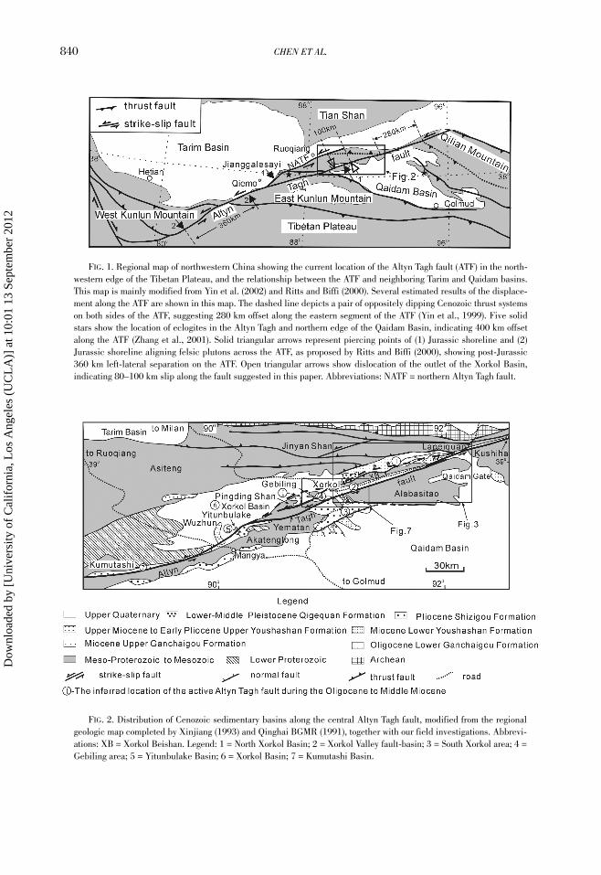
FIG. 1. Regional map of northwestern China showing the current location of the Altyn Tagh fault (ATF) in the north-western edge of the Tibetan Plateau, and the relationship between the ATF and neighboring Tarim and Qaidam basins.This map is mainly modified from Yin et al. (2002) and Ritts and Biffi (2000). Several estimated results of the displace-ment along the ATF are shown in this map. The dashed line depicts a pair of oppositely dipping Cenozoic thrust systemson both sides of the ATF, suggesting 280 km offset along the eastern segment of the ATF (Yin et al., 1999). Five solidstars show the location of eclogites in the Altyn Tagh and northern edge of the Qaidam Basin, indicating 400 km offsetalong the ATF (Zhang et al., 2001). Solid triangular arrows represent piercing points of (1) Jurassic shoreline and (2)Jurassic shoreline aligning felsic plutons across the ATF, as proposed by Ritts and Biffi (2000), showing post-Jurassic360 km left-lateral separation on the ATF. Open triangular arrows show dislocation of the outlet of the Xorkol Basin,indicating 80–100 km slip along the fault suggested in this paper. Abbreviations: NATF = northern Altyn Tagh fault.
FIG. 2. Distribution of Cenozoic sedimentary basins along the central Altyn Tagh fault, modified from the regionalgeologic map completed by Xinjiang (1993) and Qinghai BGMR (1991), together with our field investigations. Abbrevi-ations: XB = Xorkol Beishan. Legend: 1 = North Xorkol Basin; 2 = Xorkol Valley fault-basin; 3 = South Xorkol area; 4 =Gebiling area; 5 = Yitunbulake Basin; 6 = Xorkol Basin; 7 = Kumutashi Basin.
Dow
nloa
ded
by [
Uni
vers
ity o
f C
alif
orni
a, L
os A
ngel
es (
UC
LA
)] a
t 10:
01 1
3 Se
ptem
ber
2012
CENOZOIC LEFT-SLIP MOTION 841
authors have focused on the Paleozoic to Mesozoictectonic features along the Altyn Tagh fault (e.g., Xuet al., 1999), the Cenozoic basins have been poorlymapped and studied (Guo and Zhang, 1998; Li etal., 2002b). The study presented below results froman integrated investigation of interactions betweenCenozoic basin fill and deformation related to theATF strike-slip motion.
Lithostratigraphy and Structuresof Cenozoic Basins
North Xorkol BasinThe North Xorkol Basin is bounded by the EW-
trending Jinyan Shan thrust in the north, by theENE-trending Xorkol thrust along the northern edgeof the Xorkol Beishan, and by the Lapeiquan Nans-han in the south (Chen et al., 2003) (Fig. 3). Thisbasin is ~150 km long and 8~10 km wide. Fourlithostratigraphic units are recognized, based on anearly geological map of the Xorkol Sheet (XinjiangBGMR, 1981b) and our own field mapping in thesummer of 2001. Unit 1, the Xia (Xia = lower inChinese) Ganchaigou Formation, is composed ofgypsum-bearing red conglomerates and sandy con-glomerates interbedded with gray and yellow sand-stones and mudstones. This unit is of Oligocene agebased on the presence of freshwater ostracods
(Xinjiang BGMR, 1993). Alluvial and fluvial fanfacies were deposited along the northern and south-ern basin boundaries, whereas lacustrine facieswere deposited in the center of the basin. Unit 2, theMiocene Shang (Shang = upper in Chinese) Gan-chaigou Formation, consists of grey to yellow andbrown mudstones and siltstones locally interbeddedwith coal-bearing mudstones; these strata are oflacustrine origin. Unit 3, the Miocene Xia Youshas-han Formation, consists mainly of yellow conglom-erates with brown and red mudstones, siltstones,and sandstones, which in general are not well sortedwith angular pebbles and boulders, suggesting allu-vial- and pluvial-fan settings. Unit 4, the LowerQuaternary Qigequan Formation, was newly recog-nized in this basin during our field study throughregional comparison of both composition and texturewith sediments in the western Qiadam Basin southof the Altyn Tagh fault (Qinghai BGMR, 1991), aswell as its unconformable contact with lower sec-tions. It is mainly composed of light grey, sandy con-glomerates interbedded with grey and yellowsandstones and siltstones. The sediments are poorlysorted and pebbles poorly rounded. Pebbles in theconglomerates are mostly limestone, similar to rocksexposed in the hanging walls of the Jinyan andXorkoli thrusts around the basin. Flat-lying Quater-nary conglomerates lie directly over folded Tertiary
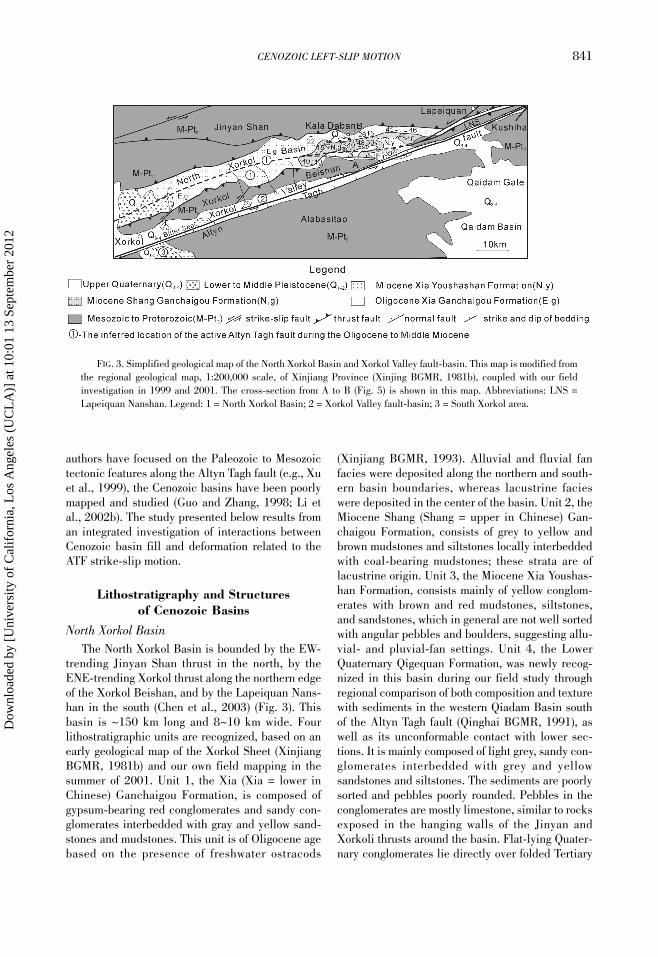
FIG. 3. Simplified geological map of the North Xorkol Basin and Xorkol Valley fault-basin. This map is modified fromthe regional geological map, 1:200,000 scale, of Xinjiang Province (Xinjing BGMR, 1981b), coupled with our fieldinvestigation in 1999 and 2001. The cross-section from A to B (Fig. 5) is shown in this map. Abbreviations: LNS =Lapeiquan Nanshan. Legend: 1 = North Xorkol Basin; 2 = Xorkol Valley fault-basin; 3 = South Xorkol area.
Dow
nloa
ded
by [
Uni
vers
ity o
f C
alif
orni
a, L
os A
ngel
es (
UC
LA
)] a
t 10:
01 1
3 Se
ptem
ber
2012

842 CHEN ET AL.
units (Fig. 4), making a distinguishable topographybecause of the resistant nature of the calcite-cemented conglomerates in the younger unit.
The Tertiary strata are gently folded. The foldaxis trends ENE parallel to the long dimension ofthe basin and the basin-bounding thrusts. The dipangle of the bedding is typically less than 30°, butlocally becomes steeper toward its margins againstthe thrusts. An oven-shaped syncline can beobserved (Fig. 5). The fold series are overlain inangular unconformity by the Lower PleistoceneQigequan conglomerates (Figs. 4 and 5). This unitalso overlies the Jinyan and Xorkoli thrusts, attest-ing that the thrusts are no longer active.
A north-dipping normal fault was newly discov-ered close to the southern edge of the basin duringour field observation (F1 in Figs. 3 and 5). The foot-wall is composed of the Oligocene Xia GanchaigouFormation; the hanging wall is made of the Miocene
Shang Ganchaigou Formation. The dip of the bed-ding in the hanging wall increases toward the fault(Fig. 5), suggesting syn-sedimentary faulting. Smallsyn-sedimentary normal faults are also found in theMiocene Shang Ganchaigou Formation and the XiaYoushashan Formation, indicating a transtensionaltectonic environment during the Miocene.
The narrow, elongate geometry of the NorthXorkol Basin and the distribution of Cenozoic sedi-ments indicate that the formation and filling processof the basin was controlled by a major strike-slipfault. As described later, a large-scale strike-slipfault, possibly the main trace of the active ATF inthe Oligocene, may lie below the basin or along itssoutheastern edge. This speculated tectonic config-uration of the ATF—in and prior to—the Oligocenerelationship may be similar to the present trans-tensional relationship between the active ATF andthe modern Xorkol Valley fault basin (Fig. 2).
FIG. 4. Unconformity contact between the Lower Quaternary conglomerate and the Tertiary mudstone. Legend: E3g =Oligocene Xia Gangchaigou Formation; N1g = Miocene Shang Gangchaigou Formation; Q1-2 = Lower–Middle PleistoceneQigequan Formation.
FIG. 5. Cross-section in the Kala Daban area, North Xorkol Basin, showing the oven-shaped syncline of Tertiary unitscapped by gently dipping Lower Quaternary conglomerates. Tertiary sediments mostly unconformably overlie Proterozoicmetamorphic rocks on both sides of the basin. The location of this cross-section is shown in A–B, Figure 3. Legend: E3g =Oligocene Xiar Gangchaigou Formation; N1g = Miocene Shang Gangchaigou Formation; Q1-2 = Lower–Middle Quater-nary; Pt = Proterozoic.
Dow
nloa
ded
by [
Uni
vers
ity o
f C
alif
orni
a, L
os A
ngel
es (
UC
LA
)] a
t 10:
01 1
3 Se
ptem
ber
2012

CENOZOIC LEFT-SLIP MOTION 843
Xorkol Valley Basin
The ENE-trending Xorkol Valley, a narrow fault-bounded depression, is 100 km long and 1–5 kmwide. It is bounded by the active Altyn Tagh faultalong the northern margin of the Alabasitao massifin the south, and the south slope of the Xorkol Bei-shan in the north (Figs. 2 and 3). Three sedimentarysequences filling the fault valley were distinguishedduring our field investigation. The youngest unitconsists of active, poorly consolidated Holocenealluvial fans, mostly developed on both sides of thevalley. The middle unit is exposed by erosion alongthe central valley, and is composed of a series of red-to-dark purple mudstones deposited in a lacustrineenvironment. They are flat-lying in the center of thevalley but become gently tilted near the ATF. Thisredbed sequence is capped on top by a gravel layer.TL dating of the gravel layer yields ages of 22 ka, 79ka, and 100 ka (SSB, 1992; Li et al., 2002a). Theseages suggest that the gravel unit was deposited inthe late Pleistocene. The oldest sedimentarysequence in the Xorkol Valley consists of gypsum-bearing red mudstones and sandy mudstones, whichare sparsely exposed along the active trace of theATF. The age of the unit is not known, although ithas been assigned to a Middle to Late Tertiary agebased on regional lithologic correlation (Xinjiang
BGMR, 1981b). In order to determine the age of thisunit, we dated one gypsum sample from this unit(sample 6151-3) using the electron spin resonancemethod, which gave an age of 1.71 Ma (Chen, 2002).This suggests that the redbed unit in the XorkolValley is Pleistocene in age.
The main trace of the active ATF lies along thecenter of the valley. It curves southeastward tobound the basin and forms a series of NW-facing tri-angular facets with a normal-slip component. Atleast two phases of triangular facets can be recog-nized along the fault (Fig. 6). The older ones are tall,uplifted, and dissected by streams, whereas theyounger ones are short and relatively continuous lat-erally. The young facets cut the older ones. TheAltyn Tagh fault continues southwestward into theSouth Gebiling Valley where the active ATF cutsseveral alluvial fans (SSB, 1992; Washburn et al.,2001).
Li et al (2002a) has proposed that the long, nar-row Xorkol Valley results from transpression startedin the Pliocene, and modern basin morphology wascreated during the Late Pleistocene. The valley isalso suggested to be controlled by thrust faults onboth sides (SSB, 1992). However, our field obser-vations and regional data do not support these sug-gestions. Neotectonic features as described abovealong the Altyn Tagh fault are more compatible with
FIG. 6. Two phases of triangular facets developed along the active Altyn Tagh fault in the southeastern edge of theXorkol Valley fault-basin. The older triangular facet is cut by a new developed triangular facet. Pluvial and fluvial fansare cut by the younger facet. Abbreviations: OTF = older triangular facet; YTF = younger triangular facet; N2 = PlioceneZhizigou Formation; Pt = Proterozoic; PF = Pluvial fan deposit; FF = Fluvial fan sediment.
Dow
nloa
ded
by [
Uni
vers
ity o
f C
alif
orni
a, L
os A
ngel
es (
UC
LA
)] a
t 10:
01 1
3 Se
ptem
ber
2012

844 CHEN ET AL.
transtension along the fault. This interpretationwould explain the southeastward tilting of the Alab-asitao massif in the Xorkol Nanshan south of theAltyn Tagh fault. Tilting is expressed by denudationof Pliocene–Middle Pleistocene strata. We alsospeculate that the South Gebiling valley and Yema-tan valley result from transtensional tectonics alongthe left-slip Altyn Tagh fault. We suggest that theXorkol valley basin began to form during the LatePleistocene because: (1) the youngest strata cut bythe ATF in the basin are Early to Middle Pleistocenein age; and (2) sedimentary facies and paleo-currentindictors show that paleo-drainage systems wereflowing across the main trace of the ATF from thePliocene to Early and Middle Pleistocene. The rela-tively small topographic relief (~400 m) also impliesyouthfulness of the Xorkol Valley (see profile E–F inFig. 7).
South Xorkol areaThe Cenozoic sedimentary units south of the
Altyn Tagh fault in the Xorkol Pass area are trun-cated by the active ATF (Figs. 7 and 8). Two Ceno-zoic lithostratigraphic units were mapped byXinjiang BGMR (1981b) in the South Xorkol area(Figs. 7 and 8): the older > 1000 m thick PlioceneShizigou Formation, and the younger 80 m thickLower to Middle Pleistocene Qigequan Formation inthe map of the Xorkol sheet (Xinjiang BGMR,1981b). The ages of the two units were determinedby magnetostratigraphic analysis (CNPC, 1992; Liuet al., 1997; Wan et al., 1999). An angular unconfor-mity between these two units was found in our fieldinvestigation and was also reported by XinjiangBGMR (1981b).
The Shizigou Formation can be divided intothree lithostraigraphic packages. Unit 1 consists
FIG. 7. Simplified geological map in the Xorkol area. Section locations of Figures 8 and 10 are shown by A, B and C,D on this map. Profile E–F shows structure of Quaternary deposits in the Xorkol Valley fault-basin and Tertiary sedi-ments in the south Xorkol area, and the more than 400 meter difference in topography between the Xorkol Valley withthe Xorkol Nanshan. Tilt-uplifting and normal-faulting resulted in the formation of more than 400 meters difference inelevation between the Xorkol Valley and the Xorkol Nanshan. Sample 6228a yields 1.83 Ma and sample 6228b yields1.02 Ma ESR (Electron Spin Resonance) ages of gypsum collected in WNW-trending fissures.
Dow
nloa
ded
by [
Uni
vers
ity o
f C
alif
orni
a, L
os A
ngel
es (
UC
LA
)] a
t 10:
01 1
3 Se
ptem
ber
2012

CENOZOIC LEFT-SLIP MOTION 845
primarily of greyish white to yellow cobble-sizedconglomerates with lenticular gravel-bearing sand-stones. Pebbles are mainly gneiss, limestone, andschist that are particularly prevalent in the basalpart of the unit (>70%). The percentage of the peb-ble clasts decreases systematically upsection fromnearly 95% to 45% from the base to the top. This isassociated with an increase in the roundness of thepebbles. Unit 2 is mainly composed of 40–60% con-glomerates interbedded with pebble sandstones andpebble-bearing mudstones. Unit 3 contains domi-nantly greyish white to greyish green and yellowmudstones interbedded with less than 30% con-glomerates. Pebbles in the conglomerates contain>50% quartzite. The upward fining of the ShizigouFormation indicates a systematic change in sedi-mentary environment, from the alluvial fans at thebottom to fluvial channels at the top. Most of the
paleocurrent indicators such as cross-bedding andpebble imbrication show a northwest-derived sourcefor the Shizigou Formation in the South Xorkoliarea. Well-developed synsedimentary growth faultsand normal faults (Fig. 9) parallel the main trace ofthe ATF, indicating a transtensional tectonic settingduring deposition of the unit. Striations mark somefault planes, showing left-lateral normal faulting.
The Qigequan Formation consists mainly (> 85%)of grey conglomerates, locally interbedded with len-ticular sandstone beds. Pebbles in the conglomer-ates typically contain well-rounded pebbles. Arelatively flat erosional surface is well preserved atthe top of the Qigequan Formation.
Subvertical WNW-striking (290°) extensionalcleavages are widespread near Xorkol Pass in theShizigou Formation (Fig. 7). Gypsum veins aredeveloped perpendicularly to the cleavage, suggest-
FIG. 8. Profile across the South Xorkol Area, showing characteristics of a typical channel filling series. The verticalscale is 6× the horizontal scale in order to show the texture inside the basin more clearly. See Figure 7 and the maplegend for explanation. Legend: Q1-2 = Lower–Middle Pleistocene Qigequan Formation; N2s = Pliocene Shizigou Forma-tion; J2-3 = Middle–Upper Jurassic; Pt2 = Proterozoic.
FIG. 9. Normal faults parallel to the main trace of the active Altyn Tagh fault in the Pliocene Shizigou Formation arewell developed. This caption is modified from a field photo, and the ruler in the picture is shown for scale.
Dow
nloa
ded
by [
Uni
vers
ity o
f C
alif
orni
a, L
os A
ngel
es (
UC
LA
)] a
t 10:
01 1
3 Se
ptem
ber
2012

846 CHEN ET AL.
ing that their development may be coeval. Two gyp-sum samples were collected from the cleavages forelectron-spin-resonance dating. They yield ages of1.02 Ma (sample 6228b) and 1.82 Ma (sample6228a), respectively (Chen et al., 2002a, 2002c).These ages indicate that the cleavage formed in theEarly Quaternary. The presence of a WNW-trendingnormal fault (F2 in Fig. 7), WNW-trending cleavage,and a drag fold in the Pliocene mudstone all suggestcompression in a WNW-ESE direction.
Gebiling areaUpper Cenozoic sediment in the Gebiling area
can also be divided into two units: the PlioceneShang Youshashan Formation and the PlioceneShizigou Formation with a thickness of over 1200meters, with the bottom not exposed (Figs. 6 and 10;Xinjiang BGMR, 1981a). The Shang YoushashanFormation might be Upper Miocene sedimentaccording to paleomagnetic data in the west QaidamBasin (CNPC, 1992; Liu et al., 1997; Wan et al.,1999). The lower part of the Shang Youshashan For-mation is characterized by brown to yellow conglom-erates interbedded with yellow sandstones andmudstones. Red siltstones and mudstones as themajor component in the upper part are locally inter-bedded with lenticular yellow conglomerates. Gyp-sum grew on the surface of the bamboo-bearingmudstone on the topmost, indicating a relativelydry-season lacustrine environment. This changefrom conglomerate to sandstone to mudstone upwardshows a complete sedimentary cycle of a fault-bounding lake series from alluvium or talus at thebottom to lacustrine on the top. The Shizigou Forma-tion here is mostly composed of yellow to grey con-glomerates with sandstones, overlying the ShangYoushashan Formation with angular unconformity(Fig. 10).
Xorkol BasinThe Xorkol Basin is expressed in topography as
a large depression inside the Altyn Tagh Range. It ismostly filled by Upper Quaternary alluvial fandeposits. Huge, prominent alluvial bajadas aredeveloped along the southern and northern marginsof the basin. Wuzhun Lake is the southernmost partof the basin and is cut by the active ATF (Fig. 2).The origin of the Xorkol Basin is poorly understood.Guo and Zhang (1998) proposed a pull-apart-basinmodel for its formation. However, neither satellite-image interpretations nor our field observations sup-port this model. Based on the morphology of thebasin, we argue that Xorkol Basin originated fromincision of a river system during the Late Tertiary.The outlet of this basin is located in Wuzhun Lake,which has been offset left-laterally by the ATF.Eroded sediments of the valley should have beenshed into the Qaidam Basin. As illustrated below,the erosional valley evolved into a depositionalbasin during the Middle to Late Quaternary as aconsequence of closure of its outlet by left-lateraljuxtaposition of the Akatenglong massif along theAltyn Tagh fault (Fig. 2).
Yitunbulake and Kumutashi basinsThe Late Cenozoic Yintunbulake basin lies along
the northern edge of the Akatenglong Shan againstthe Altyn Tagh fault (Fig. 1). The northwestern partof the basin is truncated by the active ATF. QinghaiBGMR (1986a) recognized three sedimentary unitsin the basin. The lower unit, the Xia YoushashanFormation, is composed of red mudstones andsiltstones interbedded with sandy mudstones andlocal conglomerates. They lie unconformably overProterozoic gneisses and Early Paleozoic granites.The younger Shang Youshashan Formation containsa large portion of conglomerates, whereas the over-
FIG. 10. Cross-section showing Upper Cenozoic sediments in the Gebiling area (modified from the 1:200,000 regionalmap of the Xorkol sheet of Xinjiang Province, 1981b). Legend: Q3+4 = Upper Pleistocene to Holocene; N2s = PlioceneShizigou Formation; N2y = Pliocene Shang Youshashan Formation; Pt2 = Proterozoic.
Dow
nloa
ded
by [
Uni
vers
ity o
f C
alif
orni
a, L
os A
ngel
es (
UC
LA
)] a
t 10:
01 1
3 Se
ptem
ber
2012

CENOZOIC LEFT-SLIP MOTION 847
lying Shizigou Formation is composed mainly ofgray mudstones interbedded with conglomeratesand sandstones. Contacts of these three units areunconformable (Fig. 11).
The Kumutashi Basin is 60 km long and < 2 kmwide. It is also cut by the ATF at its southeasternend (Fig. 1). Deposits in the basin consist of con-glomerates and sandstone lenses, which can be cor-related with the Shizigou Formation. They restdirectly over Proterozoic gneisses (Xinjiang BGMR,1993). The narrow, elongated geometry of theYintunbulake and Kumutashi basins implies thatboth may have originated as releasing bends alongthe ATF.
Synthesis of Cenozoic Sedimentary Sequences
A general lithostratigraphic correlation of Ceno-zoic sedimentary sequences along the central seg-ment of the Altyn Tagh fault can be established,based on the composition of sediments, sedimentaryfacies, and the internal unconformities (Fig. 12).The lowest unit is exposed in the North XorkolBasin where sedimentary facies change graduallyfrom alluvial and fluvial fan at the base, to lacus-trine in the middle, and finally to alluvial and fluvialfan facies at the top. The middle unit is composed of
the Upper Miocene to Lower Pliocene ShangYoushashan subunit, the Pliocene Shizigou subunit,and the Qigequan subunit. The lowermost subunitshows a facies change from alluvial fan at the bottomto lacustrine deposition in the top. The middle sub-unit displays a change from alluvium or talus depos-its at the bottom to fluvial sedimentation in the top.The youngest Qigequan subunit is composed ofmainly alluvial or pluvial sediments. The UpperQuaternary subunit in the uppermost section ismostly pluvial, alluvial fan, and lake deposits alongthe active trace of the ATF.
Estimates of Cenozoic Offsetsalong the ATF
Offset of a uniform strike-slip basinAs described above, the Cenozoic Yitunbulak
Basin is exposed along the ATF and is cut at itsnorthwestern end by the active ATF. There, basinsediments are directly juxtaposed against the Pre-cambrian basement. Additionally, Upper Cenozoicsedimentary rocks in the Kumutashi Basin, althoughpoorly constrained in age, extend along the north-western side of the ATF and unconformably overliePrecambrian basement. The basin is cut by theAltyn Tagh fault at its southeastern end.
FIG. 11. Unconformity between the Miocene Xia Youshashan Formation and the Pliocene Shang Youshashan Forma-tion in the Yitunbulake Basin. The backpack in the picture is about 20 cm in width. Legend: N2y = Pliocene ShangYoushashan Formation; N1y = Miocene Xia Youshashan Formation; Pt2 = Proterozoic.
Dow
nloa
ded
by [
Uni
vers
ity o
f C
alif
orni
a, L
os A
ngel
es (
UC
LA
)] a
t 10:
01 1
3 Se
ptem
ber
2012

848 CHEN ET AL.
FIG. 12. Cenozoic sedimentary features and tectonic evolution along the central Altyn Tagh fault. The vertical scaleof the stratigraphic column is based on the thickness of the strata measured during our field investigation and the geo-logical map (1:200,000 scale) completed by Xinjiang (1981a, 1981b) and Qinghai BGMR (1986). The boundary agesbetween the Cenozoic units are cited from data in the Qaidam Basin by Huang et al. (1996).
Dow
nloa
ded
by [
Uni
vers
ity o
f C
alif
orni
a, L
os A
ngel
es (
UC
LA
)] a
t 10:
01 1
3 Se
ptem
ber
2012
CENOZOIC LEFT-SLIP MOTION 849
Based on the above geologic relationships, weargue that the Neogene sediments exposed in theYitunbulak and Kumutashi basins were depositedinitially in a unified strike-slip basin formed duringthe Late Miocene and Early Pliocene along theAltyn Tagh fault. This basin was subsequently cutoff and sliced by the ATF. This correlation requiresthat more than 80 km of left-slip has occurred alongthe central ATF since the Late Pliocene (Fig. 2; seealso Fig. 14D).
Outlet of the Xorkol Basin and its correlationwith channels in the South Xorkol area
We interpret Neogene sedimentary rocksexposed in the South Xorkol area south of the AltynTagh fault to have been deposited in fluvial mean-dering environments (Fig. 8). This interpretation hasimportant implications for paleogeographic evolu-tion of the Xorkol Basin during the Pliocene andQuaternary. Because no similar lithologic units existbetween Neogene sedimentary rocks in the SouthXorkol area south of the ATF and those in the Gebil-ing area north of the fault, we suggest that the drain-age systems, as preserved in the South Xorkol area,may correspond to the outlet of a river valley that isoccupied by the Xorkol Basin. As discussed earlier,the Xorkol Basin may have originated from an ero-sional valley during the Late Neogene. Outlet chan-nels may have formed by incision of rivers intobasement rocks, which allowed eroded materials tobe transported southward across the Altyn Taghfault into the western Qaidam Basin. Thus, thepresent position of the drainage system in the SouthXorkol area may have resulted from a northeastwardshift, with respect to rocks north of the Altyn Taghfault, by continuous left-lateral strike-slip motion.This interpretation requires that the outlet channelsystem in the south Xorkoli area was originallylocated downstream of the Xorkol Basin. The com-position of the pebbles in the Shizigou Formation inthe South Xorkol area is similar to that of rocksexposed in the mountain ranges around the XorkolBasin. This further supports the hypothesis that sed-iments in the south Xorkol area were derived frommountains around the Xorkol Basin north of theAltyn Tagh fault. Stream erosion had turned theXorkol Basin into an intramountain depositionalcenter during the Late Pliocene and Quaternary.The above reconstruction yields 80–100 km left-lat-eral offset along the central ATF during Pliocene–Quaternary time (Fig. 2; see also Fig. 14D).
A Four-Stage Modelfor the Slip History of the ATF
Our field investigations across the central AltynTagh, together with basin analyses, Electron SpinResonance (ESR) dating of gypsum, and deforma-tion and depositional history of Cenozoic sedimen-tary basins, allow us to reconstruct relationshipsamong motion along the ATF, basin evolution, anddevelopment of paleotopography. In the following,we propose a four-stage strike-slip model for theevolution of the central ATF during the Cenozoic(Figs. 13 and 14).
Stage 1 (Oligocene to Middle Miocene,36.5–8 Ma)
In the Early Oligocene, the ATF was transten-sional, resulting in the formation of the North XorkolBasin (similar to the present-day Xorkol Valley).This was accompanied by the uplift of the wholeAltyn Tagh Range, although the magnitude of theuplift might have been small (Chen et al., 2001).The main trace of the Oligocene ATF may havebounded or was located inside the basin, causing itsdevelopment as a narrow and elongate feature (Figs.13A and 14A). Alluvial and pluvial fans developedalong the edge of the basin that was bounded by thepaleo-Altyn Tagh fault, which may have been asso-ciated with normal faults to accommodate transten-sion (i.e., fault F1 in Figs. 3 and 5). Lakes probablyformed in front of the major alluvial and fluvial fansdistant from the mountain fronts, where fine-grainedlacustrine sediments were deposited under rela-tively dry climatic conditions.
In the Early Miocene (the Shang Ganchaigoutime period), sedimentation was limited to the cen-ter of the basin under relatively wet climatic condi-tions. As the ATF continued transtensional motion,the depositional center in the basin migrated towardthe NNE. In the Middle–Late Miocene (ShangYoushashan time period), alluvial and fluvial fandeposits were limited to its northeastern part.Regional deformation and rapid strike-slip motionalong the ATF occurred at ~8 Ma (Chen et al., 2002;Chen et al., 2002b), causing a rapid uplifting ofmountains nearby and termination of sedimentationin the North Xorkol Basin.
Stage 2 (Late Miocene to the end of Pliocene,8–2.5 Ma)
Tertiary folds in the North Xorkol Basin weredeveloped in association with rapid incision of the
Dow
nloa
ded
by [
Uni
vers
ity o
f C
alif
orni
a, L
os A
ngel
es (
UC
LA
)] a
t 10:
01 1
3 Se
ptem
ber
2012

850 CHEN ET AL.
FIG. 13. Reconstruction showing the relationship among slip along the ATF, sedimentation in basins, and the paleo-topography, indicating four-stage strike-slip motion along the central ATF. A. Early Oligocene to Middle Miocene. B. LateMiocene to Early Pliocene. C. Late Pliocene. D. Present. Abbreviations: ATF = Altyn Tagh fault. See text for explanation.
Dow
nloa
ded
by [
Uni
vers
ity o
f C
alif
orni
a, L
os A
ngel
es (
UC
LA
)] a
t 10:
01 1
3 Se
ptem
ber
2012

CENOZOIC LEFT-SLIP MOTION 851
FIG. 14. Late Cenozoic strike-slip history along the central segment of the Altyn Tagh fault. The offset points ofTertiary sedimentary basins are marked by solid stars. The displacement of a proposed drainage outlet and its offsetcounterpart for the Xorkol Basin are marked by solid triangles. Isopach of the western Qaidam Basin is cited from Huanget al. (1996). A. Oligocene to Middle Miocene. B. Late Miocene (~8 Ma). C. Pliocene. D. Present. Abbreviations: ATF =Altyn Tagh fault. Legend: 1 = North Xorkol Basin; 2 = Xorkol Valley fault-basin; 3 = inferred location of the active AltynTagh fault during the Oligocene to Middle Miocene.
Dow
nloa
ded
by [
Uni
vers
ity o
f C
alif
orni
a, L
os A
ngel
es (
UC
LA
)] a
t 10:
01 1
3 Se
ptem
ber
2012
852 CHEN ET AL.
Xorkol Basin and sedimentation in the far-westernQaidam Basin. Meanwhile, strike-slip basins werecreated along releasing bends of the ATF (i.e.,Gebiling, Yitunbulake, and Kumutashi basins)(Figs. 13B and 14B). In the Late Pliocene, Neogenestrike-slip basins along the main fault trace weredeformed by transpressional tectonics, causing fold-ing and faulting of the Shang Youshashan Formationin the Gebiling, Yitunbulake, and Kumutashi areasand producing an unconformity between theYoushashan and Shizigou formations. The northwestside of the fault block was topographically higherthan the southeast side along the central ATF. Sev-eral drainages cut across the Altyn Tagh fault, alongwhich sediments were transported southwestward tothe western Qaidam Basin. The Pliocene ShizigouFormation in the South Xorkol area was a result ofriver incision and basin fill, providing a geologiclink between the Altyn Tagh Range and the QaidamBasin (Figs. 13C and 14C).
In the beginning stage, the South Xorkol areawas located at the upper reaches of the drainage sys-tem. Most of the sediments were derived from anearby mountain front, resulting in deposition of ill-sorted, poorly rounded conglomerates. Subse-quently, incision and offset of the source region bythe Altyn Tagh fault stretched the length of the rivercourse and the distance between the mountain frontand the South Xorkol area. As a result, the basin inthe South Xorkol area received sediments of moredistal facies characterized by better sorted, morerounded, and relatively fine grained sedimentarydeposits. As left-slip motion on the Altyn Tagh faultcontinued, the Yitunbulake-Kumutashi Basin wasoffset, and the outlet of the Xorkol Basin was cut andtranslated by the fault northeastward.
Stage 3 (Early to Middle Pleistocene)
At the end of the Neogene, most Cenozoic basinsbegan to be uplifted. All river channels ceased todevelop, and sedimentation was limited to a few locisuch as the South Xorkol area, which was filled byalluvial fan deposits of the Lower–Middle Pleis-tocene Qigequan conglomerates, with provenancefrom a nearby mountain front. Reduced extent ofsedimentary basins in the region, the presence ofWNW-trending normal faults and cleavages in theSouth Xorkol area, and the development of thrustsalong the Milan River along the northern edge of theAltyn Tagh range (Chen, 2002; Chen et al., 2002a)all imply a decrease in the normal component oftranstension along the Altyn Tagh fault and regional
NW-WNW–SE-ESE compression. The NorthXorkol Basin subsided, resulting in the depositionof the Pleistocene Qigequan conglomerates restinggently on folded Tertiary sediments.
Stage 4 (Late Pleistocene to present)
Left-slip motion on the ATF has become local-ized and caused narrow valleys such as the Xorkoland Yematan to be developed. Left-lateral strike-slip of the ATF, accompanied by a minor normalcomponent, shaped the modern topography alongthe central ATF. A change in the relative elevationbetween the Altyn Tagh range to the north and theQaidam Basin to the south across the ATF occurredin the Xorkol Pass area (Fig. 8): the Altyn Taghrange immediately north of the fault lies > 400 mlower than the western edge of the Qaidam Basin(Figs. 13D and 14D). The Xorkol Basin was shut offas a consequence of left-lateral juxtaposition of theAkatenglong massif, causing it to evolve into an iso-lated depositional basin. The relatively uniformshape of the Late Cenozoic Yitunbulake-KumatashiBasin was continuously torn off by the ATF, and thesoutheastern part of the basin was dislocated north-eastward about 80–100 km to its present location.
Discussion
Change of location of the Altyn Tagh fault
As mentioned above, we argued that the forma-tion of the North Xorkol basin was controlled by alarge strike-slip fault, similar to the relationshipbetween the present-day ATF and the Xorkol Valleybasin (Fig. 1). The inferred paleo–Altyn Tagh faultmay extend northward to the Lapeiquan area, turn-ing into a thrust fault between the Ordovician Lapei-quan Group and the Xia Ganchaigou Formation. Itjoined the northeastern end of the active ATF in theKushiha area, and is covered by the Qigequan con-glomerates in the southwestern part of the basin.Toward the southwest, the inferred strike-slip faultmight either join the present-day inactive normalfault developed along the northwestern edge of theGebiling Shan and Pingding Shan, or connect withthe active ATF in the Yematan area (Figs. 1 and 2).Lithostraigraphic evidence supports our idea of aconcealed strike-slip fault beneath the North XorkolBasin. Rocks exposed on the south side of the basin,the Xorkol Beishan, are dominantly Precambrianlimestone, which are very different in lithologicalassemblages, textures, deformational styles, andmetamorphic features from those exposed on the
Dow
nloa
ded
by [
Uni
vers
ity o
f C
alif
orni
a, L
os A
ngel
es (
UC
LA
)] a
t 10:
01 1
3 Se
ptem
ber
2012

CENOZOIC LEFT-SLIP MOTION 853
north side of the basin in the Jinyan Shan. There therocks are mainly Ordovician schists and volcanicrocks (Xinjiang BGMR, 1981b). This situation issimilar in the south Lapeiquan area, where the rocksexposed on opposite sides of the basin are different(Qinghai BGMR, 1986b). Thus, we suggest that theNorth Xorkol Basin conceals the trace of the paleo-ATF that was developed in the Oligocene. Thisreconstruction implies that the location of the maintrace of the Altyn Tagh fault has changed since theOligocene.
The unconformity between the folded Tertiarysediments below and the Lower Pleistocene con-glomerates above provides evidence for basin inver-sion of the North Xorkol Basin in the Late Tertiary.Fission track dating (Wan et al., 2001; Chen, 2002;Chen et al., 2002b) also suggests a significant cool-ing, possibly related to tectonic activity thatoccurred at ~8 Ma in the Altyn Tagh region. Thischange is coeval with the end of basin filling in theNorth Xorkol Basin.
Initiation age of the Altyn Tagh fault
The initiation age of the ATF remains controver-sial (SSB, 1992; Rumelhart et al., 1997; Ge et al.,1998; Cui et al., 2001; Liu et al., 2001; Meng et al.,2001; Yue et al., 1999, 2001; Cowgill et al., 2000,2003; Chen et al., 2001, 2002b, 2002c; Chen, 2002;Li et al., 2002b; Yin et al., 2002). Ge et al. (1998)proposed that the fault was initiated in the LatePaleocene. Li et al. (2002b) suggested that the majorstrike-slip movement along the Altyn Tagh faultzone started as early as Triassic time. 40Ar/39Ar laserdating of syntectonic muscovite and biotite fromJurassic rocks along the Altyn Tagh fault yields agesvarying from 92 to 89 Ma (Liu et al., 2000). Yue andLiou (1999) and Yue et al. (2001) suggested a two-stage evolution model of the ATF in which the north-eastern Altyn Tagh fault started to develop aroundOligocene time. Yin et al. (2002) showed that at orprior to the Middle Eocene, the Altyn Tagh fault as abounding structure of the Qaidam Basin was alreadyin existence. Cowgill et al. (2000) suggested thatboth the Altyn Tagh fault and the North Altyn Taghfault began strike slipping at the same time duringthe Oligocene and Miocene (2000). 40Ar/39Ar K-feldspar thermochronology for the central AltynTagh fault system by Cowgill et al. (2001) indicatesthat the ATF was already active as a left-lateralstrike-slip fault in the Oligocene.
The oldest lithostratigraphy in those strike-slipbasins along the central Altyn Tagh fault is
Oligocene in age. Older strata may also exist,because we do not see the base of the stratigraphicsection in the North Xorkol Basin. If the oldestlithostratigraphy in the strike-slip basin can repre-sent the onset of those related to strike-slip faulting,then the Altyn Tagh fault must have started at orprior to the beginning of the Oligocene. Significantmotion along the Altyn Tagh fault system is also sup-ported by fission track ages of apatite from granitesand gneiss across the Altyn Tagh range with agesvarying from 35.6 Ma to 8 Ma (Chen et al., 2001,2002b; Chen, 2002). Rapid changes of δ18O andδ13C values in calcite from the Jianggalesayi area,on the northwestern edge of the Altyn Tagh range(Fig. 1), starting in the Early Oligocene, also indi-cate that a significant uplift of mountain ranges tookplace during the Early Oligocene in the south (i.e.,the Tibetan Plateau), creating a rain shadow (Chen,2002; Chen et al., 2002c).
Magnitude of slip and slip rate alongthe Altyn Tagh fault
Correlation of the Yitunbulake Basin with theKumutashi Basin and the outlet-offset of the XorkolBasin provide constraints of 80–100 km fault dis-placement along the ATF. Based on our reconstruc-tion, this 80–100 km offset began to be accumulatedat 8 Ma. This age is earlier than the rapid depositionof sediments in the Qaidam Basin starting at ~5 Ma(Metivier et al., 1998). Our interpretation implies anaverage slip rate of 10–12.5 mm/yr for the ATFsince 8 Ma. However, this estimate is quite uncer-tain, because tight constraints on the age of the sed-imentation and the associated basin that is offset bythe Altyn Tagh fault are lacking.
Our result of 80–100 km offset is significantlyless than the 350–400 km offset estimated by Xu etal. (1999) and Zhang et al. (2001), based on correla-tion of Paleozoic tectonic units across the fault, andthe 360 km offset estimated by Ritts and Biffi (2000)based on the restoration of Jurassic lake shorelines.Our result is broadly compatible with the earlierestimate of slip by Peltzer and Saucier (1996) whosuggested 156 ± 40 km left-lateral offset along theAltyn Tagh fault since 10 Ma. Yue et al. (2003)recently also proposed 165 km of post-EarlyMiocene slip on the ATF.
Detailed field mapping by Yin et al. (1999)revealed a couple of dislocated Cenozoic backthrusts on both sides of the ATF, suggesting that theeastern part of the Altyn Tagh fault has accumulated280 ± 30 km strike-slip since Early Oligocene time
Dow
nloa
ded
by [
Uni
vers
ity o
f C
alif
orni
a, L
os A
ngel
es (
UC
LA
)] a
t 10:
01 1
3 Se
ptem
ber
2012

854 CHEN ET AL.
(40–32 Ma), which yield an average slip rate of 7–9mm/yr (Fig. 1). If the reconstruction is correct, thefault should have experienced 180–200 km dis-placement between the Oligocene and MiddleMiocene (40–8 Ma), yielding an average slip rate of5–6.5 mm/yr. Subsequently the fault has accumu-lated 80–100 km displacement between 8 Ma andthe present, requiring an average slip rate of 10–12.5mm/yr. These inferences indicate that the sliprate of the Altyn Tagh fault may have increased withtime.
Conclusions
Field observation and geological mapping showthat the Cenozoic sedimentary sequence along thecentral ATF can be divided into three units depend-ing on lithostratigraphy and unconformities, sug-gesting that the ATF experienced a four-stagestrike-slip motion during the Cenozoic. Evidencefrom both sedimentation in Cenozoic basins anduplift of mountains suggest that the ATF began itssinistral strike-slip in the Early Oligocene. The off-set of a Cenozoic original uniform strike-slip basinand the dislocation of the outlet of the Xorkol Basinindicated 80–100 km sinistral offset along the faultsince 8 Ma; the average Late Cenozoic slip rate is10–12.5 mm/yr.
Acknowledgments
This study was supported by the Major StateBasic Research Program of People’s Republic ofChina (No. 2001CB409808 and 2001CB7110013),the National Natural Science Foundation for YoungGeologists (No. 40102022), and the U.S. NationalScience Foundation.
REFERENCES
Burchfiel, B. C., Deng, Q., Molnar, P., Royden, L. H.,Wang, Y., Zhang, P., and Zhang W., 1989, Intracrustaldetachment with zones of continental deformation:Geology, v. 17, p. 748–752.
Chen, X. H., Yin, A., George, G. E., Cowgill, E. S., Grove,M., Harrison, T. M., and Wang, X. F., 2003, Two phasesof Mesozoic north-south extension in the eastern AltynTagh Range, northern Tibetan Plateau: Tectonics, v,22(5), p. 1053 [10.1029/2001TC001336].
Chen, Z. L., 2002, Cenozoic strike-slip history of the cen-tral Altyn Tagh fault—new evidences from the sedi-mentary process and uplift of mountains; Ph.D. thesis,
Chinese Academy of Geological Sciences, 76 p. (inChinese with English abstract).
Chen, Z. L., Gao, J., Zhang, Y. Q., Wang, X. F., and Chen,X. H., 2002a, Electron Spin Resonance Dating of theLate Cenozoic deformation along the central AltunFault: Geological Review, v. 48 (suppl.), p. 140–145(in Chinese with English abstract).
Chen, Z. L., Wang, J. L., Wang, X. F., Chen, X. H., andPan, J. H., 2002b, Rapid strike-slip of the Altyn Taghfault at 8 Ma and its geological implications: Acta Geo-logica Sinica, v. 23, no. 4, p. 295–300 (in Chinese withEnglish abstract).
Chen, Z. L., Wang, X. F., Feng, X. H., Wang, C. Q., Chen,X. H., and Liu, J., 2002c, New evidence from stableisotope for the uplift of mountains in northern edge ofthe Qinghai-Tibetan plateau: Sciences in China (E), v.32 (suppl.), p. 1–10 (in Chinese with English abstract).
Chen, Z. L., Zhang, Y. Q., Wang, X. F., and Chen, X. H.,2001, Fission track dating of apatite constrains on theCenozoic uplift of the Altyn Tagh mountain: Acta Geo-logica Sinica, v. 22, no. 5, p. 413–418 (in Chinese withEnglish abstract).
CNPC (China National Petroleum Corporation Coordi-nated Group of the Tertiary Research), 1992, Correla-tion between the Tertiary strata in oil-gas-bearingareas of China and the typical sequence in Europe andAmerica: Chinese Sciences Bulletin, v. 36, no. 6, p.491–496.
Cowgill, E., Yin, A., Harrison, T. M., Grove, M., and Wang,X. F., 2001, Oligocene initiation of the central AltynTagh fault system inferred from 40AR/39Ar K-feldsparthermochronology: EOS (Transactions of the AmericanGeophysical Union), v. 82, no. 47, p. F-1018.
Cowgill, E., Yin, A., Harrison, T. M., and Wang X. F.,2003, Reconstruction of the Altyn Tagh fault based onU-Pb geochronology: Role of back thrusts, mantlesutures, and heterogeneous crustal strength in formingthe Tibetan plateau: Journal of Geophysical Research,v. 108 no. 7, p. 2346 [10.1029/2002JB002080].
Cowgill, E., Yin, A., Wang, X. F., and Zhang, Q., 2000, Isthe North Altyn fault part of a strike-slip duplex alongthe Altyn Tagh fault system?: Geology, v. 28, p. 255–258.
Cui, J. W., Li, L., Yang, J. S., Yue, Y. J., Li, P. W., Zhang,J. X., and Chen, W., 2001, The Altun fault: Its geome-try, nature, and mode of growth: Acta Geologica Sinica,v. 73, no. 3, p. 133–143 (in Chinese with Englishabstract).
Ge, X. H., Zhang, M. S., and Liu, Y. J., 1998, Scientificproblems and research trends in studying the Altunfault: Modern Geology, v. 12, no. 3, p. 295–301 (inChinese with English abstract).
Gehrels, G. E., Yin, A., and Wang, X. F., 2003a, Detritalzircon geochronology of the northeastern Tibet: Geo-logical Society of America Bulletin, v. 115, p. 881–896.
Dow
nloa
ded
by [
Uni
vers
ity o
f C
alif
orni
a, L
os A
ngel
es (
UC
LA
)] a
t 10:
01 1
3 Se
ptem
ber
2012

CENOZOIC LEFT-SLIP MOTION 855
______, 2003b, Magmatic history of the Altyn Tagh, NanShan, and Qilian Shan region of western China: Jour-nal of Geophysical Research, v. 108, no. 9, p. 2423[10.1029/2002JB001876].
Guo, S. M., and Xiang, H. F., 1998, Study on spatial-tem-poral distribution of the left-lateral offsets sinceOligocene–Miocene of the Altyn Tagh fault system:Seismology and Geology, v. 20, p. 9–17 (in Chinesewith English abstract).
Guo, Z. J., and Zhang, Z. C., 1998, Types and evolution ofthe Altyn Tagh strike-slip basins: Geological Review,v. 44, p. 357–364 (in Chinese with English abstract).
Huang, H.C., Huang, Q.H., and Ma, Y.S., 1996, Geologyand oil and gas prediction of the Qaidam Basin.Beijing: Geological Publishing House, 108 p. (in Chi-nese with English abstract).
Li, H. B., Yang, J. S., Shi, R. D., Wu, C. L., Tapponnier, P.,Wang, Y. S., Zhang, J. X., and Meng, F. C., 2002a,Determination of the Altyn Tagh strike-slip fault basinand its relationship with mountains: Chinese ScienceBulletin, v. 47, p. 572–577.
Li, H. B., Yang, J. S., Xu, Z. Q., Wu, C. L., Wang, Y. S., Shi,R. D., Liou, J. G., Tapponnier, P., and Irelan, R. T.,2002b, Geological and chronological evidence of Indo-Chinese strike-slip movement in the Altyn Tagh faultzone: Chinese Science Bulletin, v. 47, p. 27–32.
Liu, Y. J., Ye, H., Ge, X., Chen, W., Liu, J., Ren, S., andPan, H., 2001, Lasr probe 40Ar/39Ar dating of mica onthe deformed rocks from Altyn Tagh and its tectonicimplications, western China: Chinese Science Bulle-tin, v. 46, p. 322–325.
Liu, Z. C., Wang, J., Wang, Y. J., Sun, S. Y., Chen, Y. A.,Zhang, J. X., Jiang, W. Y., Fan, L. S., Li, J. Q., Yang, F.,Qu, P., and Chen, H. L., 1997, On lower Tertiary chro-nostratigraphy and climatostratigraphy of MangyaiDepression in western Qaidam Basin: Journal ofStratigraphy, v. 20, no. 2, p. 104–113 (in Chinese withEnglish abstract).
Meng, Q. R., Hu, J. M., and Yang, F. Z., 2001, Timing andmagnitude of displacement on the Altyn Tagh fault:Constraints from stratigraphic correlation of adjoiningTarim and Qaidam basins, NW China: Terra Nova, v.13, p. 86–91.
Metivier, F., Gaudermer, Y., Tapponnier, P., and Meyer, B.,1998, Northeastward growth of the Tibet Plateaudeduced from balanced reconstruction of two sedimen-tary basins: The Qaidam and Hexi corridor: Tectonics,v. 17, p. 823–842.
Meyer, B., Tapponnier, P. , Bourjot, L., Metivier, F., Gaud-emer, Y., Peltzer, G., Guo., S., and Chen, Z., 1998,Crustal thickening in Gansu-Qinghai, lithosphericmantle subduction, and oblique, strike-slip controlledgrowth of the Tibet Plateau: Geophysical Journal Inter-national, v. 135, p. 1–47.
Meyer, B., Tapponnier, P., Gaudemer, Y., Peltzer, G., Guo,S., and Chen, Z., 1996, Rate of left-lateral movementalong the eastern segment of the Altyn Tagh Fault, east
of 96E (China): Geophysical Journal International, v.124, p. 29–44.
Molnar, P., Burchfiel, B. C., Zhao, Z., Lian, K., Wang, S.,and Huang, M., 1987, Geomorphic evidence for activefaulting in the Altyn Tagh and northern Tibet and qual-itative estimates of its contribution to the convergenceof India and Eurasia: Geology, v. 15, p. 249–253.
Molnar, P., and Tapponnier, P., 1975, Cenozoic tectonics ofAsia: Effects of continental collision: Science, v. 189,p. 419–426.
Peltzer, G., and Saucier, F., 1996, Present-day kinematicsof Asia derived from geologic fault rates: Journal ofGeophysical Research, v. 101, p. 27,943–27,956.
Peltzer, G., Tapponnier, P., and Armijo, R., 1989, Magni-tude of late Quaternary left-lateral displacementsalong the northern edge of Tibet: Science, v. 246, p.1285–1289.
Qinghai BGMR (Qinghai Bureau of Geology and MineralResources), 1986a, Geological map of the MangyaSheet: Beijing, China, Geological Publishing House,scale 1:200,000, 121 p. (in Chinese).
Qinghai BGMR (Qinghai Bureau of Geology and MineralResources), 1986b, Geological map of the EboliangSheet: Beijing, China, Geological Publishing House,scale 1:200,000, 327 p. (in Chinese).
Qinghai BGMR (Qinghai Bureau of Geology and MineralResources), 1991, Geologic history of the Qinghairegion: Beijing, China, Geological Publishing House,662 p. (in Chinese with English abstract).
Ritts, B. D., and Biffi, U., 2000, Magnitude of post-MiddleJurassic (Bajocian) displacement on the central AltynTagh fault system, northwest China: Geological Societyof America Bulletin, v. 112, p. 61–74.
Ritts, B. D., Yue, Y. J., and Graham, S. A., 2003, Oli-gocene–Miocene tectonics and sedimentation alongthe Altyn Tagh fault, northern Tibetan plateau: Analy-sis of the Xorkol, Subei, and Aksay basins [abs.]:Abstracts of the 18th HKT workshop, Monte Verita,Switzerland, p. 103.
Rumelhart, P. E., Yin, A., Cowgill, E., Butler, R., Zhang,Q., and Wang, X. F., 1999, Cenozoic vertical-axis rota-tion of the Altyn Tagh fault system: Geology, v. 27, p.819–822.
Rumelhart, P. E., An, Y., Rick, B., and Zhang, Q., 1997,Oligocene initiation of deformation of northern Tibet:Evidence from the Tarim basin, NW China [abs.]: Geo-logical Society of America Abstracts with Programs, v.29, p. A-143.
Shen, Z. K., Wang, M., Li, Y., Jackson, D. D., Yin, A.,Dong, D., and Fang, P., 2001, GPS study of crustaldeformation associated with the Altyn Tagh fault sys-tem: Journal of Geophysical Research, v. 106, p.30,607–30,621.
SSB (State Seismological Bureau), 1992, The Altyn Taghactive fault: Beijing, China: Seismological PublishingHouse, 319 p. (in Chinese with English abstract).
Dow
nloa
ded
by [
Uni
vers
ity o
f C
alif
orni
a, L
os A
ngel
es (
UC
LA
)] a
t 10:
01 1
3 Se
ptem
ber
2012

856 CHEN ET AL.
Tapponnier, P., and Molnar, P., 1977, Active faulting andtectonics in China: Journal of Geophysical Research, v.82, p. 2905–2930.
Wan, J. L, Wang, Y., and Li, Q., 2001, FT evidence ofnorthern Altyn uplift in Late Cenozoic: Bulletin ofMineralogy, Petrology, and Geochemistry, v. 20, p.222–224 (in Chinese with English abstract).
Wan, J., Wang, Y. J., Liu, Z. C., Li, J. Q., and Xi, P., 1999,Cenozoic environmental evolution of the Qaidam basinand its implications for the uplift of the TibetanPlateau and the drying of ventral Asia: Paleogeogra-phy, Paleoclimatology, Palaeoecology, v. 152, p. 37–47.
Wang, E., 1997, Displacement and timing along the north-ern strand of the Altyn Tagh fault zone, Northern Tibet:Earth and Planetary Science Letters, v. 150, p. 55–64.
Washburn, Z., Arrowsmith, J. R., Forman, L. S., Cowgill,E., Wang, X., Zhang, Y. Q., and Chen, Z. L., 2001, LateHolocene earthquake history of the central Altyn Taghfault, China: Geology, v. 29, p. 1051–1054.
Xinjiang BGMR (Xinjiang Bureau of Geology and MineralResources), 1981a, Geological map of the Bash-ikaogong Sheet: Beijing, China, Geological PublishingHouse, scale 1:200,000, 236 p. (in Chinese).
______, 1981b, Geological map of the Xorkol Sheet:Beijing, China, Geological Publishing House, scale1:200,000, 237 p. (in Chinese).
______, 1993, Geologic history of the Xinjiang UygurAutonomous Region: Beijing, China: Geological Pub-lishing House, 681 p. (in Chinese with Englishabstract).
Xiang, H. F., Guo, S. M., Zhang, W. X., and Zhang, B. L.,2000, River offset and slip rate of the east segment ofAltun Tagh fault zone, Gansu, China since the Quater-nary: Seismology and Geology, v. 22, no. 2, p. 129–138(in Chinese with English abstract).
Xu, Z. Q., Yang, J. S., Zhang, J. X., and Cui, J. W., 1999,A comparison between the tectonic units on the twosides of the Altun sinistral strike-slip fault and themechanism of lithospheric shearing: Acta GeologicaActa, v. 73, p. 193–205 (in Chinese with Englishabstract).
Yang, J. S., Xu, Z. Q., Zhang, J. X., Chu, J. Y., Zhang,R. Y., and Liou, J. Q., 2001, Tectonic significance of
early Paleozoic high-pressure rocks in Altun-Qaidam-Qilian Mountains, northwest China, in Hendrix, M. S.,and Davis, G. A., Paleozoic and Mesozoic tectonic evo-lution of central and eastern Asia: From continentalassembly to intracontinental deformation: GeologicalSociety of America Memoir, v. 194, p. 151–170.
Yin, A., Gehrels, G., Chen X., and Wang, X. F., 1999, Evi-dence for 280 km of Cenozoic left slip motion along theeastern segment of the Altyn Tagh fault system, west-ern China [abs.]: EOS (Transactions of the AmericanGeophysical Union), v. 80, p. F1018.
Yin, A., and Harrison, T. M., 2000, Geologic evolution ofthe Himalayan-Tibetan orogen: Annual Review ofEarth and Planetary Sciences, v. 28, p. 211–280.
Yin, A., and Nie, S., 1996, A Phanerozoic palinspasticreconstruction of China and its neighboring regions, inYin, A., and Harrison, T. M., eds., The tectonics ofAsia: New York, NY, Cambridge University Press, p.442–485.
Yin, A., Rumelhart P. E., Bulter, R., Cowgill, E., Harrison,T. M., Foster, D. A., Ingersoll, R. V., Zhang, Q., Zhou,X. Q., Wang, X. F., Hanson, A., and Raza, A., 2002,Tectonic history of the Altyn Tagh fault system innorthern Tibet inferred from Cenozoic sedimentation:Geological Society of America Bulletin, v. 114, p.1257–1295.
Yue, Y. J., and Liou, J. G., 1999, Two-stage evolutionmodel for the Altyn Tagh Fault, China: Geology, v. 27,p. 227–230.
Yue, Y. J., Ritts, B. D. and Graham, S. A., 2001, Initiationand long-term slip history of the Altyn Tagh fault:International Geology Review, v. 43, p. 1087–1093.
Yue, Y. J., Ritts, B. D., Graham, S. A, Wooden, J., Gehrels,G., and Zhang, Z. C., 2003, Slowing extrusion tecton-ics: Lowered estimate of post-Early Miocene long-termslip rate for the Altyn Tagh fault, China [abs.], inAbstracts of the 18th Himalaya-Karakoram-Tibetworkshop, Ascona, Switzerland, p. 134.
Zhang, J. X., Zhang, Z. M., Xu, Z. Q., Yang, J. S., and Cui,J. W., 2001, Petrology and geochronology of eclogitesfrom the western segment of the Altyn Tagh, northwest-ern China: Lithos, v. 56, p. 187–206.
Dow
nloa
ded
by [
Uni
vers
ity o
f C
alif
orni
a, L
os A
ngel
es (
UC
LA
)] a
t 10:
01 1
3 Se
ptem
ber
2012