Embed Size (px)
Citation preview

The crustal structure from the Altai Mountains to the Altyn Tagh
fault, northwest China
Youxue Wang,1,2,3 Walter D. Mooney,2 Xuecheng Yuan,4 and Robert G. Coleman5
Received 30 March 2001; revised 7 November 2002; accepted 17 March 2003; published 28 June 2003.
[1] We present a new crustal section across northwest China based on a seismic refractionprofile and geologic mapping. The 1100-km-long section crosses the southern margin ofthe Chinese Altai Mountains, Junggar Accretional Belt and eastern Junggar basin,easternmost Tianshan Mountains, and easternmost Tarim basin. The crustal velocitystructure and Poisson’s ratio (s), which provide a constraint on crustal composition,were determined from P and S wave data. Despite the complex geology, the crustalthickness along the entire profile is nearly uniform at 50 km. The thickest crust (56 km)occurs at the northern end of the profile beneath the Altai Mountains and the thinnest(46 km) crust is beneath the Junggar basin. Beneath surficial sediments, the crust isfound to have three layers with P wave velocities (Vp) of 6.0–6.3, 6.3–6.6, and6.9–7.0 km/s, respectively. The southern half of the profile, including the eastern TianshanMountains and eastern margin of the Tarim basin, shows low P wave velocities ands = 0.25 to a depth of 30 km, which suggests a quartz-rich, granitic upper crustalcomposition. The northern half of the profile below the Altai Mountains and JunggarAccretional Belt has a higher Poisson’s ratio of s = 0.26–0.27 to a depth of 30 km,indicative of an intermediate crustal composition. The entire 1100-km-long profile isunderlain by a 15–30 km thick high velocity (6.9–7.0 km/s; s = 0.26–0.28) lower-crustallayer that we interpret to have a bulk composition of mafic granulite. At the southern endof the profile, a 5-km-thick midcrustal low-velocity layer (Vp = 5.9 km/s, s = 0.25)underlies the Tianshan and the region to the south, and may be indicative of a near-horizontal detachment interface. Pn velocities are �7.7–7.8 km/s between the Tianshanand the Junggar basin, and �7.9–8.0 km/s below the Altai Mountains and eastern marginof the Tarim basin. We interpret the consistent three-layer stratification of the crust toindicate that the crust has undergone partial melting and differentiation after Paleozoicterrane accretion. The thickness (50 km) of the crust appears to be related to compressionresulting from the Indo-Asian collision. INDEX TERMS: 7205 Seismology: Continental crust
(1242); 7218 Seismology: Lithosphere and upper mantle; 8110 Tectonophysics: Continental tectonics—
general (0905); KEYWORDS: crustal structure, China, seismic refraction, compression, Indo-Asian collision
Citation: Wang, Y., W. D. Mooney, X. Yuan, and R. G. Coleman, The crustal structure from the Altai Mountains to the Altyn Tagh
fault, northwest China, J. Geophys. Res., 108(B6), 2322, doi:10.1029/2001JB000552, 2003.
1. Introduction
[2] Northwest China consists of a 2000-km-wide orogen-ic belt located between the Siberian craton and the northernedge of the Tibetan plateau. The Indo-Asian collision is thelatest in a series of tectonic events that have built thisimpressive orogenic belt. This region offers excellent fieldexposures that document a wide range of geological pro-cesses that have formed and modified the Earth’s crust.
Northwest China is considered a ‘‘type locality’’ for studiesof crustal accretion, deformation, and stabilization [Yangand Yang, 1981; Zhang et al., 1984; Ren et al., 1987; Yuanet al., 1992; Avouac and Tapponnier, 1993; Dong, 1993;Berzin et al., 1994; Rowly, 1996; Yin and Nie, 1996].[3] As part of a geoscience transect that extended from
the Altai Mountains to Taiwan, a 1100-km-long seismicrefraction survey was conducted across northwest China(Figures 1 and 2) by the former Ministry of Geology andMineral Resources (MGMR). The three-component seismicdata were acquired in 1988. The goal of this project was togain a better understanding of the deep crustal structurebeneath different tectonic provinces in the area and toprovide crustal information for mineral resources develop-ment [Xu and Wang, 1991; Wang, 1992; Yuan et al., 1992].[4] Prior information regarding the seismic properties of
the crust and upper mantle in northwest China have beenobtained using local and teleseismic tomography [Liu et al.,
JOURNAL OF GEOPHYSICAL RESEARCH, VOL. 108, NO. B6, 2322, doi:10.1029/2001JB000552, 2003
1China University of Geoscience, Beijing, China.2U.S. Geological Survey, Menlo Park, California, USA.3Now at Department of Resources and Environmental Engineering,
Guilin Institute of Technology, Guilin, China.4China Geological Survey, Beijing, China.5Department of Geology and Environmental Sciences, Stanford
University, Stanford, California, USA.
This paper is not subject to U.S. copyright.Published in 2003 by the American Geophysical Union.
ESE 7 - 1

1989; Roecker et al., 1993; Teng et al., 1992, 1994], theanalysis of seismic surface waves [Feng et al., 1980; Cottonand Avouac, 1994; Mahdi and Pavlis, 1998], seismicrefraction studies in the southwestern Tarim basin [Kao etal., 2001], and modeling of gravity data [Burov et al.,1990]. The majority of prior work has focused on the regionof the Tianshan where a crustal thickness of 50–55 km hasbeen reported [Roecker et al., 1993]. Prior work has notincluded the crustal structure of the Altai Mountains or theeastern edge of the Tarim basin, as we present here. Cottonand Avouac [1994] report low shear wave velocities in ourstudy area, a result that is consistent with our observations.There have been geophysical studies of the Junngar basin,
but these have mainly addressed shallow depths wherehydrocarbon deposits are known [e.g., Song et al., 2000]and these data have not been made available.[5] This information, combined with recent advances in
processing techniques of three-component data, have en-abled us to model both the P and S wave velocity structure(Vp and Vs, respectively), and to infer compositional changeswithin the crust and uppermost mantle using Poisson’s ratio[Castagna, 1985; Holbrook et al., 1988, 1992; Eesley, 1989;Gajewski et al., 1990; Romero et al., 1993; Zandt et al.,1994; Kosminskaya, 1995; Krilov et al., 1995; Christensenand Mooney, 1995; Christensen, 1996; Catchings and Lee,1996; Hawman, 1996; Kern et al., 1999; Swenson et al.,
Figure 1. Topographic relief map of southeast Asia with seismic transect indicated by a heavy dark line.The entire transect is located north of the Tibetan Plateau, and crosses from the Altai Mountains to theeastern Tarim basin. The transect is composed of four linear segments. The box indicates the areadepicted in Figure 2. The dashed line across the eastern Tibetan Plateau is the southward continuation ofthe seismic transect reported here.
ESE 7 - 2 WANG ET AL.: CRUSTAL STRUCTURE OF THE ALTAI MOUNTAINS

2000]. In this paper we present the P and S wave velocitystructure of the crust from our seismic refraction data, anddescribe an interpretive geological crustal section that isbased on these results and geologic mapping.
2. Geological Setting
[6] Southern Eurasia, of which northwestern China is apart, was formed by the coalescence and accretion ofdiverse crustal fragments from a series of collisional eventsduring Paleozoic and Mesozoic times [Yang and Yang,1981; Zhang et al., 1984; Ren et al., 1987; Zhang, 1997;Berzin et al., 1994; Carroll et al., 1995; Rowly, 1996; Yin
and Nie, 1996; Neil and Houseman, 1997; Yin et al., 1998].Most of western China, including the Altai Mountains,Junggar basin, Tianshan Mountains (henceforth simply theTianshan, since ‘‘shan’’ means ‘‘mountains’’), and theeastern margin of the Tarim basin (Figure 2), where assem-bled prior to the mid-Cenozoic Indo-Asian collision thatreshaped the region and reactivated older structures [Molnarand Tapponnier, 1975; Tao and Lu, 1981; Tapponnier et al.,1982, 2001; Windley et al., 1990; Dong, 1993; Avouac andTapponnier, 1993; Avouac et al., 1993; Liu et al., 1994;Allen et al., 1995; Yin and Nie, 1996].[7] The tectonic terranes comprising the study area are
bounded by faults and inferred sutures (Figure 2). Some of
Figure 2. Geological map of the region investigated by the seismic transect. The transect location isindicated by a solid line; circled numbers 1 through 12 indicate shot point locations. The northernmostshot point (SP1) is located at the boundary between the Altai Mountains and the Junggar AccretionalBelt. The southernmost shot point (SP12) is located adjacent to the Altyn Tagh fault. The seismic transectcrosses, in addition, the eastern Junggar basin, Bogda Shan arc (SP5-6), the Turpan-Hami basin (SP6-9),the Tienshan (SP9-10), and the eastern Tarim basin (SP10-12).
WANG ET AL.: CRUSTAL STRUCTURE OF THE ALTAI MOUNTAINS ESE 7 - 3

these faults are seismically active and have been sites ofmajor historic earthquakes, while others are aseismic andmark the sutures between Paleozoic and Mesozoic terranes.The geologic makeup and tectonic history of each separateterrane is briefly discussed from north to south.
2.1. The South Margin of the Altai Mountains andthe Junggar Fold (Accretional) Belt
[8] The Altai Mountains (north of shot point 1, Figure 2)includes a 12-km-thick early Paleozoic accretionary wedge,consisting of metamorphosed sandstone, shales, and minorlimestones. Intercalated within these sedimentary sequencesare mid-Paleozoic island arc volcanics and calc-alkalineintrusives [Sengor et al., 1993; Qu and He, 1993; Cunning-ham et al., 1996a, 1996b]. Gneissic rocks along the south-ern border are believed to comprise the Precambrianbasement [Feng et al., 1989], but the existence of olderbasement in the Altai is not yet resolved. Windley et al.[1994] suggest that these gneisses may represent Precam-brian to early Paleozoic accreted fragments. This suggestionis supported by Berzin et al. [1994] who show the AltaiMountains as a microcontinent with possible Precambrianbasement [Bibkova et al., 1992].[9] The Junggar Accretional Belt (shot points 1, 2, and 3;
Figure 2) is bound by the Irtysh and Kelimali faults andconsists mainly of accreted Devonian and Carboniferoussediments and volcanics with a few scattered Ordovicianand Silurian rocks [Feng et al., 1980], and is a part of thesouth margin of the Altai Block. Dismembered ophiolitesand associated cherts that record the involvement of oceaniccrust of the Paleo-Junggar Ocean in the accretion processare concentrated along the Irtysh, Kelimali, and Almantifaults (Figure 2). The ages of these rocks indicate continuedsubduction and accretion from the Middle Devonian to theEarly Carboniferous. Within the Altai and Junggar Moun-tains, Paleozoic calc-alkaline intrusions were formed abovea northward-dipping oceanic slab. The Paleozoic calc-alka-line plutons predate the final Late Carboniferous to EarlyPermian amalgamation along the North and central Tian-shan suture.
2.2. The Junggar Basin
[10] The sediments of the Junggar basin (shot points 4and 5; Figure 2) have been deposited on a basement similarto that of the Junggar Accretionary Belt [Feng et al., 1980;Tao and Lu, 1981; Kwon et al., 1989; Carroll et al., 1990,1995; Allen et al., 1991, 1995]. The basin is triangular inshape and filled with deposits thickening gradually fromnorth to south, and the largest accumulations being foundalong the Bogda Shan island arc (Figure 2). The basalUpper Permian deposits of the Junggar basin are nonmarineand were deposited within the subsiding foreland basin[Kwon et al., 1989; Carroll et al., 1990]. Geologicalreconstructions suggest that the basement underlying theJunggar basin consists of incompletely subducted, imbri-cated mid-Carboniferous oceanic crust and trench-wedgevolcanoclastic sediment.
2.3. The Bogda Shan Volcanic Arc
[11] The Carboniferous Bogda Shan volcanic arc, southof the Junggar basin (shot points 5 and 6; Figure 2), was
formed as a consequence of northward subduction andextension during and prior to the accretion of the Paleozoicand Precambrian Tianshan blocks. The arc appears to becentered in the Bogda Shan where thick sections of Car-boniferous submarine pyroclastics and basalt-andesite flowsextend north and south across the present Junggar andTurpan basins [Coleman, 1989] (Figure 2). To the west ofthe Bogda Shan, the Carboniferous volcanics rest uncon-formably on an early Paleozoic accretionary complex oftrench sediment and dismembered ophiolite. Evidence for aPrecambrian basement underlying these Carboniferous vol-canics is not seen along the northern front of the BogdaShan [Ren et al., 1987]. Similar Permian lacustrine depositsand overlying felsic clastics in both basins suggest that anAndean-type arc did not separate the Turpan and Junggarbasins at this time [Greene et al., 1997].
2.4. The Turpan-Hami Basin
[12] The depositional sequences in the Turpan-Hamibasin (shot points 7, 8, and 9; Figure 2) are similar to thosein the Junggar basin and consist of basal Carboniferousandesitic volcanics, overlain by Permian lacustrine mud-stones interlayered with continental fluvial and volcanicsediments. The Permian sequence is overlain by nearly3000 m of Triassic and Jurassic foreland-style continentaldeposits, rich in coals and lacustrine mudstones [Carroll etal., 1995; Greene et al., 1997]. The Carboniferous volcano-clastic sequences exposed on the southern margins of theTurpan-Hami basin are intruded by late Paleozoic calc-alkaline granites related to the Bogda Shan arc.
2.5. The Tianshan
[13] Located south of the Kushi fault (shot point 10;Figure 2) (also called the South Tianshan fault or NicolaevLine), the Tianshan has been tightly compressed duringMesozoic and Cenozoic time. The central Tianshan consistsof Proterozoic gneiss and schist intruded by Paleozoic calc-alkaline granite [Allen et al., 1992, 1993; Windley et al.,1990]. These older rocks are overlain by passive margincarbonate and continental clastics of Middle and UpperProterozoic age [Ren et al., 1987]. The rock formations ofthe South Tianshan merge with the passive margin of theTarim Platform. A late Paleozoic subduction scenario be-tween the Tarim and central Tianshan has been suggested byAllen et al. [1992] based on fragments of ophiolite bodiesfound within the South Tianshan fault zone. Further east,the central Tianshan wedges out as a result of dextral strike-slip faulting and crustal subduction of the central Tianshanblock under the north-facing passive margin of the TarimPlatform (Figure 1). Finally, the Cenozoic shortening of thisarea is considered to result from the collision of the IndianCraton to the south [Carroll et al., 1995; Windley et al.,1994; Hendrix et al., 1994]. The Cenozoic imbrication, andthickening of the crustal section south of the Bogda Shan,was accomplished by thrusting and strike-slip faulting at thesurface, submerging the central Tianshan under the Tarimpassive margin (Figure 2). Present-day strike-slip motionalong the Altyn Tagh (Figure 2) and thrusting in the area[Zhou and Graham, 1996] has, together with convergence,produced an unusually thick (50 km) continental crustbeneath the seismic transect at this location.
ESE 7 - 4 WANG ET AL.: CRUSTAL STRUCTURE OF THE ALTAI MOUNTAINS

2.6. The Tarim Basin
[14] The Tarim basin (shot points 11 and 12; Figure 2) isfilled with a thick (�6 km along our profile) forelandsequence of Mesozoic and Cenozoic continental sediments.These are underlain by Paleozoic shallow marine sediments,and Late Proterozoic rocks which floor the entire basin [Jiaet al., 1991; Allen et al., 1991; Sobel, 1999]. The AltynTagh fault system has exposed possible Archean basementon the southern boundary of this craton. These inferredolder rocks are intruded by early Paleozoic calc-alkalinegranite (Figure 2).
2.7. The Altyn Tagh Fault and the Qaidam Depression
[15] The Altyn Tagh fault zone (shot point 12; Figure 2)truncates the E-W trending Qaidam units, juxtaposing themagainst the mildly deformed Tarim Platform sequences[Zhou and Graham, 1996; Ritts and Biffi, 2000]. TheQaidam Depression is filled with Mesozoic to Cenozoicbasinal sequences of lacustrine and fluvial fan deposits[Carroll et al., 1990; Ritts, 1995]. The basement consistsof a late Paleozoic fold belt containing active continental-
margin sediments and volcanics. The entire sequence isstrongly folded and is related to the E-W trending Kunlunsuture which shows evidence of Paleozoic convergencewith its high-pressure/low-temperature metamorphic rocks[Chen et al., 1999].
3. Seismic Data
3.1. Acquisition and Processing
[16] Seismic energy was provided by 12 chemical explo-sive shots fired in boreholes. The charge size ranged from1500 to 4000 kg, sufficient to provide clear first arrivals to amaximum distance of 300 km. The distance between shotpoints ranged from 63 to 125 km, and the interval betweenportable seismographs was between 2 and 4 km. The profilewas recorded along existing roads and provided four nearlystraight profile segments (Figure 2).[17] To assist in phase correlation, record sections with
reduction velocities of 6.0 and 3.46 km/s were used forP and S waves, respectively. The timescale used for S waverecord sections was compressed by a factor of 0.58 in order
Figure 3. Record sections of shot point SP1. (a) Trace-normalized band-pass filtered (0–8 Hz) S waverecord section with a reduction velocity of 3.46 km/s and a factor of 0.58 in timescale with respect to Pwaverecord section; (b) trace-normalized P wave record section with a reduction velocity of 6.00 km/s. Thewide-angle reflection from the Moho (PmP) is delayed by the thick (56 km) crust of the Altai Mountains.
WANG ET AL.: CRUSTAL STRUCTURE OF THE ALTAI MOUNTAINS ESE 7 - 5

to match the P wave arrival times. To avoid the small timeshift introduced by digital filters, unfiltered P wave datawere used for phase correlation and travel time picking. Inorder to improve the signal-to-noise ratio for phase corre-lation, the S wave data were filtered with a 0–8 Hz bandpass.
3.2. Correlation of Phases
[18] Standard nomenclature has been used to identify firstand secondary arrival phases. The upper crustal refractioncommonly referred to as Pg and Sg actually corresponds totwo travel time segments (Figures 3 and 4). The first,usually a short travel time branch that propagates very nearthe shot point, is a diving wave within the sedimentarylayer, whereas the second and much longer travel timebranch is the refraction (or diving wave) from the top ofbasement. True first-arrival refractions from the middle orlower crust were rarely observed. Much more apparent werewide-angle reflections, that are labeled P1P and S1S, P2Pand S2S, and PLP and SLS, corresponding to reflections fromthe top of the middle crust, lower crust, and low-velocitylayer (where present) for P and S waves, respectively. The
phase PmP (SmS) is the reflection from the Moho, and Pn
(Sn) is the refraction from the Moho.[19] In general, Pg is a very clear phase that contains
detailed information about the upper crustal velocity struc-ture. The Sg phase is not always as clear as Pg because of alower signal-to-noise ratio. The first segment of Pg (Sg)corresponds to waves propagating in the sediments orweathered layer, and is the first arrival within a distanceof 50 km of the shot points. P wave velocities observedwithin the three basins that are crossed (Figure 2) indicate ahigher velocity gradient than is measured within the crys-talline crust. The apparent velocities for Pg and Sg from shotpoints SP4 (Figure 4) and SP7 (Figure 5), which are locatedin the Junggar and Turpan basins, respectively, are relativelylow (<5.00 km/s for P wave and <2.60 km/s for S wave)corresponding to thick sediments. Where sediments areabsent, the velocities of Pg and Sg are about 6.0 and3.46 km/s, respectively (Figures 3 and 6).[20] The phase that arrives after Pg (Sg) is the wide-angle
reflection P1P (S1S) from the top of the middle crust (6.3–6.6 km/s). At certain distances, P1P seems to be a firstarrival because the Pg energy is too weak to be detected.
Figure 4. Record sections of shot point SP4. (a) Trace-normalized band-pass filtered (0–8 Hz) S waverecord section (transverse component) with a reduction velocity of 3.46 km/s and a factor of 0.58 intimescale with respect to P wave record section; (b) trace-normalized P wave record section with areduction velocity of 6.00 km/s. The wide-angle reflection from the Moho (PmP) and the refracted arrivalfrom below the Moho (Pn) are very clear on the P wave record section.
ESE 7 - 6 WANG ET AL.: CRUSTAL STRUCTURE OF THE ALTAI MOUNTAINS

The phase P2P (S2S) corresponds to a reflection from thetop of the lower crust (6.8–7.0 km/s), and is visible onmany of the record sections. P2P (S2S) intersects PmP (SmS)(the Moho reflection) at a distance of 200–250 km from theshot. Despite the dominance of the PmP (SmS) phase, theP2P (S2S) phase can often be clearly identified.[21] To the south of shot point SP8 (Figure 2), another
phase, referred to as PLP (SLS) (Figure 6), can be identi-fied just above the signal-to-noise level in the recordsections between P1P (S1S) and P2P (S2S). Despite itsweak energy, this phase is visible in the trace-normalizedrecord section when compared to the very strong PmP(SmS) phase (Figure 6). PLP (SLS) nearly parallels P1P(S1S), but has a lower average velocity. It is the low-velocity zone (LVZ) that gives rise to this phase thatdelays the Moho reflections in the related regions (Figures5 and 6). No obvious time delay appears for the phasesbefore P2P (S2S), and therefore the phase PLP (SLS) isinterpreted to be a reflection from the top of a low-velocitylayer beneath the southern section of the profile (Tianshan,Turpan-Hami basin, and eastern Tarim basin).[22] The Moho reflection PmP (SmS) is the dominant
phase on all record sections at distances greater than
100–150 km. Due to the existence of a complex crustalstructure, especially the midcrustal low-velocity layer be-low the southern part of the profile, the phase PmP (SmS)sometimes exists in two segments with a clear time delayseparating them. Examples of this phenomenon canbe found in the record sections from shot points SP7(Figure 5) and SP10 (Figure 6). In the record section ofSP7, the arrivals of PmP (SmS) reflections arrive later at adistance greater than 170 km. Likewise for SP10, thetravel times of PmP and SmS are delayed at distances lessthan about 200 km from the shot in the northern segment.These results indicate that the northern limit of the deepcrustal low-velocity layer must be located somewherebetween SP8 and SP9 along the profile near the northernedge of the Tianshan (Figure 2).[23] Pn was observed as the first arrival in several record
sections at distances greater than 200 km (Figures 4–6).The apparent velocity of Pn ranges from 7.6 to 7.9 km/s.The lowest values occur beneath the Junggar and Turpan-Hami basins, but Pn has a high apparent velocity beneaththe Altai Mountains, Junggar Accretional Belt, TianshanAccretional Belt, and eastern margin of the Tarim platform.Sn is also visible in some S wave sections. Forward
Figure 5. Record sections of shot point SP7. (a) Trace-normalized band-pass filtered (0–8 Hz) S waverecord section with a reduction velocity of 3.46 km/s and a factor of 0.58 in timescale with respect toP wave record section; (b) trace-normalized P wave record section with a reduction velocity of 6.0 km/s.Intracrustal wide-angle reflections, the reflection from Moho (PmP), and the refraction from below Mohoare all clearly recorded.
WANG ET AL.: CRUSTAL STRUCTURE OF THE ALTAI MOUNTAINS ESE 7 - 7

modeling of Pn observations was used to determine thevelocity structure of the uppermost mantle.
4. Modeling the Data
[24] Using the abovementioned phase correlations, thefirst arrivals of Pg were used to invert for the upper crustalvelocity structure using a finite difference tomographicmethod [Kelly et al., 1976; Hole, 1992; Ohminato andChouet, 1997]. The reflection phases P1P, PLP, P2P, andPmP were used to determine the approximate velocitystructure of the middle to lower crust using a combinationof the x2-t2 method [Giese et al., 1976] and the reflectivitymethod [Fuchs and Muller, 1971]. After establishing aninitial crustal P wave velocity structure, the final P wavemodel was determined using 2-D forward raytracing [Cer-veny et al., 1977; Cerveny and Psencik, 1984]. Travel timesand amplitudes of the various phases on the record sectionswere fitted by adjusting the velocities and depths of theboundaries with the raytracing method (Figures 7 and 8),thus establishing the final P wave velocity model. The raymethod that we have used to model the data is biasedtoward relatively flat-laying structures with discrete seismicdiscontinuities. We admit the possibility of alternate seismic
models with gradational velocity boundaries rather thanfirst-order discontinuities. However, the main conclusionsof this paper would not change significantly if such modelswere obtained.[25] In recent years, there has been an increased interest
in modeling both the P and S wave velocity structure of thecrust because this combination provides better constraintson composition [e.g., Castagna, 1985; Holbrook et al.,1988, 1992; Eesley, 1989; Gajewski et al., 1990; Kosmin-skaya, 1995; Rudnick and Fountain, 1995; Zandt andAmmon, 1995; Krilov et al., 1995; Hauksson and Haae,1997; Musacchio et al., 1997; Eberhart-Phillips and Mi-chael, 1998; Menke et al., 1998; Stoerzel and Simithson,1998; Catchings, 1999]. We have modeled the S wave databy assuming the depths to all boundaries are those obtainedfrom the P waves. We were able to fit the travel times forthe crystalline upper crust by replacing the P wave veloc-ities with S wave velocities assuming a Poisson’s ratio of0.25 in the initial S wave model. Two-dimensional forwardmodeling was then used to fit the S wave reflections andcreate a complete S wave model for the crust.[26] Uncertainties in the final velocity model primarily
depend on the correct identification of the various phasesand the density of rays, the shot point interval, the receiver
Figure 6. Record sections of shot point SP10. (a) Trace-normalized band-pass filtered (0–8 Hz) S waverecord section with a reduction velocity of 3.46 km/s and a factor of 0.58 in timescale with respect toP wave record section; (b) trace-normalized P wave record section with a reduction velocity of 6.0 km/s.The S wave record section shows a very clear wide-angle reflection from the Moho, as well as clearP wave and S wave refracted arrivals from below Moho.
ESE 7 - 8 WANG ET AL.: CRUSTAL STRUCTURE OF THE ALTAI MOUNTAINS

density, and the degree of lateral variations in the thicknessof surficial sediments. Our result has shown that, dependingon the uniformity of the structure and the density of therays, the ability to resolve velocity and depths to theinterfaces are 2 and 5%, respectively (Table 1). Thus avelocity of 7.0 km/s has an uncertainty of ±0.14 km/s and alayer depth of 30 km has an uncertainty of ±1.5 km. TheVp/Vs ratio has an uncertainty of 4%. Figure 9 shows athree-dimensional perspective of the final structural modelalong the seismic refraction profile. P wave velocity andPoisson’s ratio are indicated in this figure.
4.1. Crustal Seismic Velocity Structure
[27] The crustal model (Figures 9 and 10, and Table 1)shows many significant features. As expected, the Junggar,Turpan-Hami, and Tarim sedimentary basins have lowvelocities and steep velocity gradients with Vp = 3.6–5.8 km/s and Vs = 2.3–3.3 km/s. The Turpan-Hami basinhas the greatest thickness (10 km) of sediments. Beneath the
eastern Tarim basin, the velocity increases from 4.4 km/snear the surface (Vs = 2.7 km/s) to 5.8 km/s (Vs = 3.3 km/s)at a depth of �6 km. The strong velocity contrast betweenthe basin fill and the crystalline basement clearly outlinesthe 2-D configuration of the sedimentary basins. Alongmost of the profile, the velocity of the crystalline upper crustis 6.0–6.1 km/s at depths 8–14 km. The Bogda Shan,however, is underlain by a higher-velocity block (Vp =6.30 km/s, Vs = 3.7 km/s) at the same depth range.[28] A remarkable feature of the crustal model is that the
middle crust has a nearly uniform 16 km thickness to thenorth of the Tianshan despite the complex surface geology.However, the southward-decreasing average seismic veloc-ities in this layer, with a LVZ, indicates a nonuniformcomposition. From the Altai block to the Turpan-Hamibasin, middle-crustal velocities are 6.5–6.6 km/s. Furthersouth, beneath the Tianshan, Tarim basin, and Qaidambasin, the velocity drops to 6.3 km/s, and a 5-km-thickLVZ with an estimated P wave velocity of 5.9 km/s is
Figure 7. Observed and synthetic record sections of P wave and ray coverage for shot SP7. The wide-angle reflection from the Moho is very clear, as is the refracted arrival from below the Moho (Pn).
WANG ET AL.: CRUSTAL STRUCTURE OF THE ALTAI MOUNTAINS ESE 7 - 9

located at �25 km depth. The LVZ causes clearly observedtime delays of the Moho reflections recorded south ofTianshan (Figures 5–8).[29] The entire seismic profile is underlain by a remark-
ably uniform high-velocity (6.9–7.0 km/s) lower crustwhose top is at a depth of 25–30 km. The lower crust hasan average thickness of about 20 km. The maximum lowercrustal thickness (30 km) is found to the north, beneath theAltai Mountains, where the Moho is at a maximum depth of55 km (Figure 9). The thickening of the lower crust isaccommodated by both deepening of the Moho and thinning(isostatic uplift) of the upper crust. The thinnest (15 km)portion of the lower crust underlies the Junggar basin, wherethe Moho depth is 46 km. South of the Junggar basin, theMoho depth increases to about 50 km and then deepensabruptly (to about 68 km) to the south of the Altyn Taghfault [Wang et al., 1997].
[30] The seismic velocity of the uppermost mantle (Pn) isless than or equal to the global average (8.09 km/s) in allparts of the study area. The lowest values (7.7–7.8 km/s)occur beneath the Junggar and Turpan-Hami basins. Be-neath the Altai Mountains, Junggar Accretional Belt, Tian-shan Accretional Belt, and eastern margin of the Tarimplatform, Pn velocity is 8.0 km/s.
4.2. Poisson’s Ratio
[31] Poisson’s ratio shows the largest lateral variationwithin the uppermost crust (Figure 9). Poisson’s ratioincreases with depth in the upper crust, especially in theMesozoic and Cenozoic basins, such as the Junggar, Tur-pan-Hami, and Dunhuang basins (Figure 2). We note thatour measured velocities can also be affected by crustaltemperatures. However, our seismic profile passes througha region of generally low surface heat flow [40–45 mW/m2;
Figure 8. Observed and synthetic record sections of P wave and ray coverage for shot SP10. Wide-angle reflections are clearly observed, as is the refracted arrival from below the Moho (Pn).
ESE 7 - 10 WANG ET AL.: CRUSTAL STRUCTURE OF THE ALTAI MOUNTAINS

Artemieva and Mooney, 2001]. For temperatures more than10% below the solidus, thermal effects act approximatelyequally for P wave and S wave velocities [Christensen,1996]. Therefore we do not expect that temperature willsignificantly alter the measured Poisson’s ratio in the upperand middle crust. The observed Pn velocity along the centralportion of our profile is a low 7.7 km/s, nearly 0.4 km/slower than the global average Pn velocity (8.09 km/s). If thislow Pn velocity is due to a warm uppermost mantle, and notseismic anisotropy, we would expect that thermal effectswould reduce Poisson’s ratio in the uppermost mantle andlower crust. While we have not estimated Poisson’s ratio in
the uppermost mantle, we do observe a lower Poisson’sratio (0.26) in the central portion of the lower crust. Errorestimates for Poisson’s ratios are presented in Table 1.[32] The Mesozoic and Cenozoic sedimentary basins
have low values of Poisson’s ratio (0.19–0.22), with thelowest value in the Turpan-Hami basin. Poisson’s ratio inthe upper crust is about 0.25 in most areas, except beneaththe Bogda Shan, where the value is about 0.26.[33] On the basis of Poisson’s ratio, the middle crust
along the transect can be divided at the Bogda Shan into anorthern and southern segment. In the northern segment,including the Bogda Shan, the middle crust shows a
Figure 9. Three-dimensional perspective view of the crustal structure along the seismic transect fromthe Altai Mountains to the Altyn Tagh fault. Dashed lines indicate the top of the crystalline basement.Three distinct layers are present along this transect that we identify as the upper (6.1–6.3 km/s), middle(6.3–6.6 km/s) and lower (6.9–7.0 km/s) crust. P wave velocity values are given, as is Poisson’s ratio (inparenthesis). The Moho, which is remarkably flat from the Junggar basin to the Altyn Tagh fault, isshown as a heavy, dark line.
Table 1. The Velocity and Poisson’s Ratio (s) Structure for Different Tectonic Units
Tectonic Unit Parameters Uncertainty, % Sediments Upper Crust Middle Crust LV Zone Lower Crust Crust Thickness km/s
Altai H, km 5 2.12 7.60 16.00 . . . 729.40 56.00 7.90Vp, km/s 2 5.50–6.00 6.10 6.60 . . . 7.00s 3 0.25 0.25 0.26 . . . 0.28
Junggar Basin H, km 5 5.10 5.40 21.10 . . . 14.50 46.00 7.70Vp, km/s 2 4.3–5.8 6.10 6.50 . . . 6.90s 3 0.22 0.26 0.27 . . . 0.27
Bogda Shan H, km 5 3.65 10.40 16.50 . . . 20.30 51.00 7.70Vp, km/s 2 5.40–5.90 6.30 6.50 . . . 6.90s 3 0.25 0.25 0.26 . . . 0.27
Turpan-Hami Basin H, km 5 9.84 5.00 15.00 . . . 19.10 49.00 7.70Vp, km/s 2 3.60–5.90 6.10 6.50 . . . 6.90s 3 0.19 0.25 0.25 . . . 0.26
Tianshan H, km 5 2.74 9.00 12.40 7.40 18.20 50.00 7.90Vp, km/s 2 5.80–6.00 6.10 6.30 5.90 7.00s 3 0.25 0.25 0.25 0.25 0.27
Tarim H, km 5 6.07 3.00 13.00 5.30 21.70 49.00 8.00Vp, km/s 2 4.40–5.80 6.00 6.30 5.90 7.00s 3 0.20 0.25 0.25 0.25 0.27
WANG ET AL.: CRUSTAL STRUCTURE OF THE ALTAI MOUNTAINS ESE 7 - 11

Poisson’s ratio as high as 0.27. However, the middle crust tothe south of the Bogda Shan has a more typical Poisson’sratio of around 0.25. Poisson’s ratio in the lower crust is0.26–0.28, with the highest value (0.28) beneath the Altaiblock, and the lowest value (0.26) beneath the Turpan-Hamibasin. As discussed below, the profile segment with highervalues of Poisson’s ratio correlates with Nd, Sr, and Pbisotopic anomalies determined on the granitic plutons [Hop-son et al., 2003] indicating crust sources of oceanic (mafic)origin beneath the Junggar, Bogda Shan, and Turpan-Hamiblocks. Isotopic ratios indicate that more felsic continentalcrust is present beneath the central and South Tianshan[Hopson et al., 2003].
4.3. Geological Interpretation
[34] We have constructed a geologic cross section fromthe surface to the Moho along the seismic profile (Figure10). The cross section uses information on surface geology
from Tao and Lu [1981], Coleman [1989], Yuan et al.[1992], Teng et al. [1994], and Allen and Vincent [1999].We describe this 1100-km-long cross section from north(Altai Mountains) to south (Altyn Tagh fault).[35] The greatest total crustal thickness (55 km) and
lower-crustal thickness (30 km) are found north of theKelimali fault in the Altai Mountains and Junggar Accre-tional Belt where the high Poisson’s ratio (0.28) in the lowercrust is consistent with a mafic lower-crustal composition.The lower crust is less than 15 km thick beneath the Junggarbasin. There has been much discussion concerning theorigin of the deep basement of the Junggar basin, whichmay be composed of either Precambrian crystalline rocks oraccreted Paleozoic metasedimentary and/or imbricated maf-ic oceanic rocks [Yang and Yang, 1981; Tao and Lu, 1981].[36] In the area of the Bogda Shan Arc and Turpan-Hami
basin the crustal structure inferred from geology indicates acomplex evolution, and the composition and origin of the
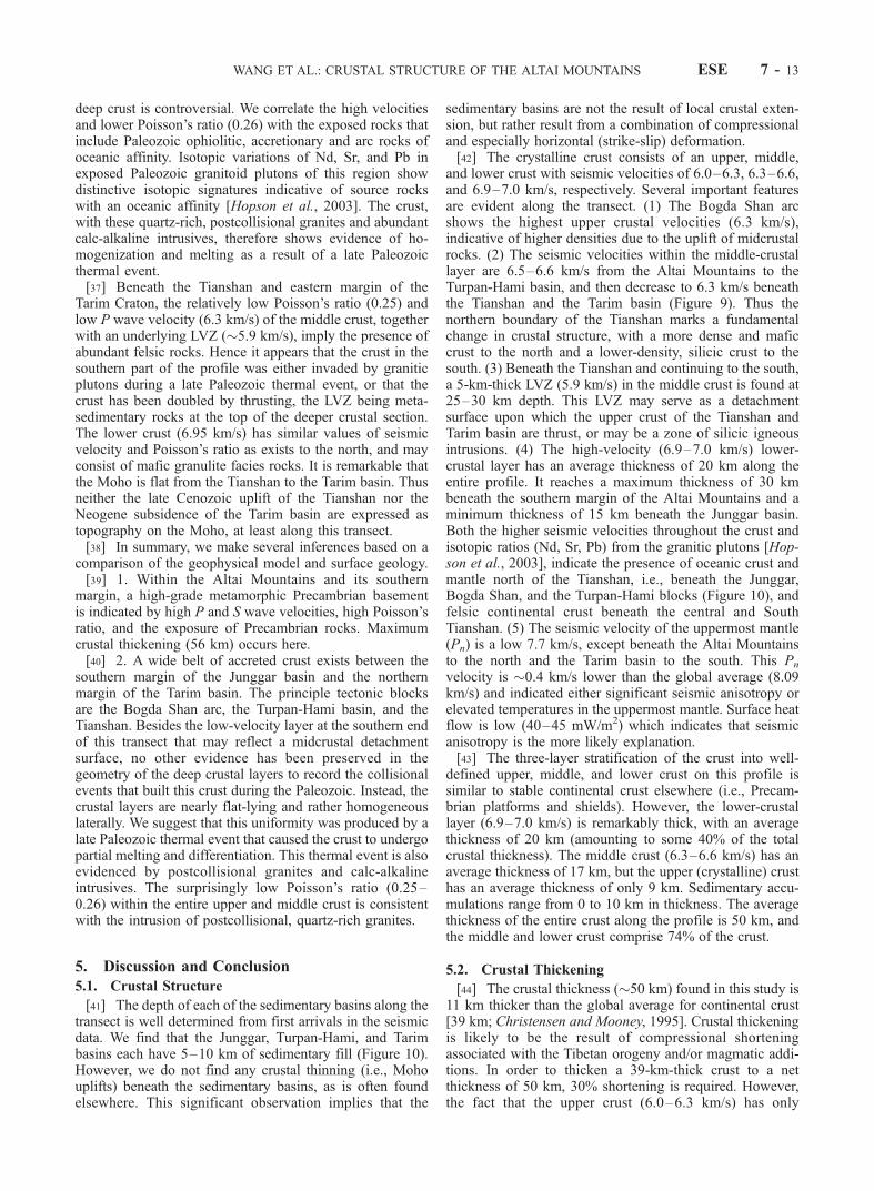
Figure 10. Geological cross section of the transect from the Altai Mountains to the Altyn Tagh faultwith P wave velocity structure superimposed. This section follows the transect and therefore has somedistortion crossing the Bogda Shan volcanic arc. The seismic transect crosses diverse crustal blocks thatwere accreted during the Paleozoic, but results show a relatively uniform, flat-layered, �50-km-thickcrust (cf., Figure 9). The measured seismic velocities within the uniform, three-layered structure are takento indicate that the crust has undergone partial melting and differentiation after the Paleozoic accretionaryphase. The greater-than-average crustal thickness is interpreted as due to the subsequent Indo-Asiancollision. The nonuniform composition of the accreted crustal blocks (i.e., continental and oceanicterranes, accretionary prisms, and magmatic arcs) is reflected in the variation in the measured averagecrustal velocity from north to south along the profile.
ESE 7 - 12 WANG ET AL.: CRUSTAL STRUCTURE OF THE ALTAI MOUNTAINS
deep crust is controversial. We correlate the high velocitiesand lower Poisson’s ratio (0.26) with the exposed rocks thatinclude Paleozoic ophiolitic, accretionary and arc rocks ofoceanic affinity. Isotopic variations of Nd, Sr, and Pb inexposed Paleozoic granitoid plutons of this region showdistinctive isotopic signatures indicative of source rockswith an oceanic affinity [Hopson et al., 2003]. The crust,with these quartz-rich, postcollisional granites and abundantcalc-alkaline intrusives, therefore shows evidence of ho-mogenization and melting as a result of a late Paleozoicthermal event.[37] Beneath the Tianshan and eastern margin of the
Tarim Craton, the relatively low Poisson’s ratio (0.25) andlow P wave velocity (6.3 km/s) of the middle crust, togetherwith an underlying LVZ (�5.9 km/s), imply the presence ofabundant felsic rocks. Hence it appears that the crust in thesouthern part of the profile was either invaded by graniticplutons during a late Paleozoic thermal event, or that thecrust has been doubled by thrusting, the LVZ being meta-sedimentary rocks at the top of the deeper crustal section.The lower crust (6.95 km/s) has similar values of seismicvelocity and Poisson’s ratio as exists to the north, and mayconsist of mafic granulite facies rocks. It is remarkable thatthe Moho is flat from the Tianshan to the Tarim basin. Thusneither the late Cenozoic uplift of the Tianshan nor theNeogene subsidence of the Tarim basin are expressed astopography on the Moho, at least along this transect.[38] In summary, we make several inferences based on a
comparison of the geophysical model and surface geology.[39] 1. Within the Altai Mountains and its southern
margin, a high-grade metamorphic Precambrian basementis indicated by high P and S wave velocities, high Poisson’sratio, and the exposure of Precambrian rocks. Maximumcrustal thickening (56 km) occurs here.[40] 2. A wide belt of accreted crust exists between the
southern margin of the Junggar basin and the northernmargin of the Tarim basin. The principle tectonic blocksare the Bogda Shan arc, the Turpan-Hami basin, and theTianshan. Besides the low-velocity layer at the southern endof this transect that may reflect a midcrustal detachmentsurface, no other evidence has been preserved in thegeometry of the deep crustal layers to record the collisionalevents that built this crust during the Paleozoic. Instead, thecrustal layers are nearly flat-lying and rather homogeneouslaterally. We suggest that this uniformity was produced by alate Paleozoic thermal event that caused the crust to undergopartial melting and differentiation. This thermal event is alsoevidenced by postcollisional granites and calc-alkalineintrusives. The surprisingly low Poisson’s ratio (0.25–0.26) within the entire upper and middle crust is consistentwith the intrusion of postcollisional, quartz-rich granites.
5. Discussion and Conclusion
5.1. Crustal Structure
[41] The depth of each of the sedimentary basins along thetransect is well determined from first arrivals in the seismicdata. We find that the Junggar, Turpan-Hami, and Tarimbasins each have 5–10 km of sedimentary fill (Figure 10).However, we do not find any crustal thinning (i.e., Mohouplifts) beneath the sedimentary basins, as is often foundelsewhere. This significant observation implies that the
sedimentary basins are not the result of local crustal exten-sion, but rather result from a combination of compressionaland especially horizontal (strike-slip) deformation.[42] The crystalline crust consists of an upper, middle,
and lower crust with seismic velocities of 6.0–6.3, 6.3–6.6,and 6.9–7.0 km/s, respectively. Several important featuresare evident along the transect. (1) The Bogda Shan arcshows the highest upper crustal velocities (6.3 km/s),indicative of higher densities due to the uplift of midcrustalrocks. (2) The seismic velocities within the middle-crustallayer are 6.5–6.6 km/s from the Altai Mountains to theTurpan-Hami basin, and then decrease to 6.3 km/s beneaththe Tianshan and the Tarim basin (Figure 9). Thus thenorthern boundary of the Tianshan marks a fundamentalchange in crustal structure, with a more dense and maficcrust to the north and a lower-density, silicic crust to thesouth. (3) Beneath the Tianshan and continuing to the south,a 5-km-thick LVZ (5.9 km/s) in the middle crust is found at25–30 km depth. This LVZ may serve as a detachmentsurface upon which the upper crust of the Tianshan andTarim basin are thrust, or may be a zone of silicic igneousintrusions. (4) The high-velocity (6.9–7.0 km/s) lower-crustal layer has an average thickness of 20 km along theentire profile. It reaches a maximum thickness of 30 kmbeneath the southern margin of the Altai Mountains and aminimum thickness of 15 km beneath the Junggar basin.Both the higher seismic velocities throughout the crust andisotopic ratios (Nd, Sr, Pb) from the granitic plutons [Hop-son et al., 2003], indicate the presence of oceanic crust andmantle north of the Tianshan, i.e., beneath the Junggar,Bogda Shan, and the Turpan-Hami blocks (Figure 10), andfelsic continental crust beneath the central and SouthTianshan. (5) The seismic velocity of the uppermost mantle(Pn) is a low 7.7 km/s, except beneath the Altai Mountainsto the north and the Tarim basin to the south. This Pn
velocity is �0.4 km/s lower than the global average (8.09km/s) and indicated either significant seismic anisotropy orelevated temperatures in the uppermost mantle. Surface heatflow is low (40–45 mW/m2) which indicates that seismicanisotropy is the more likely explanation.[43] The three-layer stratification of the crust into well-
defined upper, middle, and lower crust on this profile issimilar to stable continental crust elsewhere (i.e., Precam-brian platforms and shields). However, the lower-crustallayer (6.9–7.0 km/s) is remarkably thick, with an averagethickness of 20 km (amounting to some 40% of the totalcrustal thickness). The middle crust (6.3–6.6 km/s) has anaverage thickness of 17 km, but the upper (crystalline) crusthas an average thickness of only 9 km. Sedimentary accu-mulations range from 0 to 10 km in thickness. The averagethickness of the entire crust along the profile is 50 km, andthe middle and lower crust comprise 74% of the crust.
5.2. Crustal Thickening
[44] The crustal thickness (�50 km) found in this study is11 km thicker than the global average for continental crust[39 km; Christensen and Mooney, 1995]. Crustal thickeningis likely to be the result of compressional shorteningassociated with the Tibetan orogeny and/or magmatic addi-tions. In order to thicken a 39-km-thick crust to a netthickness of 50 km, 30% shortening is required. However,the fact that the upper crust (6.0–6.3 km/s) has only
WANG ET AL.: CRUSTAL STRUCTURE OF THE ALTAI MOUNTAINS ESE 7 - 13

approximately half the thickness of the middle and lowercrust suggests that isostatic uplift has caused erosion ofabout 10 km of the (shortened) upper crust. If we tentativelyaccept that 10 km of crust has been removed, then theshortening along the profile amounts to 50%. A majoruncertainty in this calculation is the initial crustal thickness.[45] Alternatively, the crust may have been thickened by
magmatic additions. If magmatism was mainly of interme-diate to mafic composition, thickening will have occurredmainly in the middle and lower crust. Silicic intrusions mayhave thickened the upper crust, which was subsequentlythinned by erosion processes. The present geophysical datado not allow us to discern which process, compression ormagmatic addition, has dominated the mechanism of crustalthickening.
5.3. Crustal Composition
[46] The interpretation of crustal composition from seis-mic velocity measurements has recently been reviewed byHolbrook et al. [1992], Rudnick and Fountain [1995], andChristensen and Mooney [1995]. We begin our discussionwith the measured Vp structure, and then proceed to the Vp/Vs ratio, or equivalently, Poisson’s ratio.[47] The average P wave velocity of the crystalline crust
varies along the seismic transect, with important boundariescoinciding with: (1) the southern Junggar Accretional Beltand (2) the northern Tianshan. Beneath the Altai Mountainsand the Junggar Accretional Belt (SP1 and SP2; Figure 10)the average crustal velocity is 6.7 km/s. This value, which issignificantly higher than the global average (6.45 km/s), isdue to two factors: (1) the moderately high seismic velocity(6.5–6.6 km/s) of the middle crust and (2) the unusuallylarge thickness (30 km) of the high-velocity (7.0 km/s)lower crust (Figure 10). Between the Junggar basin and thenorthern flank of the Tianshan (SP3 through SP8; Figure10) the average crustal velocity is 6.5 km/s, a value that isessentially equal to the global average. From the Tianshanto the Altyn Tagh fault, the average crustal velocity is6.3 km/s, a value that is 0.15 km/s lower than the globalaverage and is significantly lower (0.2–0.4 km/s) than theportion of the transect north of the Tianshan. Thus threecrustal types may be clearly distinguished along this tran-sect on the basis of average crustal velocities of 6.3, 6.5, and6.7 km/s. The origin of these crustal types may be attributedto: (1) diverse accreted terranes (magmatic arcs, oceaniccrust, continental fragments) that form the crust and (2)different amounts of crustal shortening and postaccretionalmagmatic additions that have modified the crust.[48] Christensen and Mooney [1995] present statistical
averages of seismic velocity as a function of depth forcontinental crust, and relate seismic velocity to rock types.Upper crustal velocities in the study area are consistent withgeologically observed metasedimentary and felsic intrusiverocks. Measured Poisson’s ratio for these rocks (0.25) areconsistent with this interpretation. As noted above, seismicvelocities within the middle crust are lower beneath theTianshan and eastern Tarim basin (Vp = 6.3 km/s) thanunder the terranes to the north (Vp = 6.5–6.6 km/s), andPoisson’s ratio increases slightly from south (0.25) to north(0.26–0.27). These observations indicate that the bulkcomposition of middle crust beneath the Tianshan is closeto that of a tonalite or granodiorite, and becomes more mafic
to the north (i.e., equivalent to a diorite). For example, anincrease in the abundance of amphibolite in the middle crustfrom 5% beneath the Tianshan to about 35% beneath theterranes to the north would satisfy the observations [cf.,Figure 18 of Christensen and Mooney, 1995]. The seismicvelocity (6.9–7.0 km/s) and Poisson’s ratio (0.26–0.28) ofthe lower crust are remarkably uniform along the entire1100 km transect. The seismic measurements are consistentwith a mafic composition (mafic granulite and/or maficgarnet-granulite), or anorthosite (less likely). Hopson et al.[2003] suggested that the lower crust consists largely ofmafic migmatite in which a large mafic (amphibolite andgranulite) and ultramafic (meta peridotite) component isresponsible for the 6.9–7.0 km/s P wave velocity, whereas asubordinate granitoid (i.e., metadiorite, metatonalite, andleucotrondhjemite) component is responsible for a some-what lower-than-expected Poisson’s ratio. However, thesecompositions could provide a Poisson’s ratio as high as0.29–0.31, which is 0.01–0.05 higher than the measuredvalues. Granulite grade metapelite provides the best fit tothe seismic velocity data, but it seems unlikely, based onheat flow constraints and volumetric considerations, that thelower continental crust is composed of a thick (20 km) layerof metapelite over a distance of 1100 km. Thus we favormafic granulite composition.[49] Our crustal cross section (Figure 10), which is based
on surface geology and P and S wave seismic velocities,reveals a 50-km-thick crust that is remarkable for its rela-tively uniform three-layer stratification. The crustal structure(layer velocities, thickness, and Poisson’s ratio) of the centralportion of the profile (i.e., from the Turpan-Hami basin to theJunggar basin) is similar to that of Precambrian platformsand shields [Rudnick and Fountain, 1995; Christensen andMooney, 1995]. We therefore conclude that the accretionaryprocess combined with compression and �50% crustalshortening, with some magmatic additions to the base ofthe crust, is a valid description of the formation andevolution of stable continental crust. The outstanding majorquestion in this study area is the composition and configu-ration of the underlying mantle lithosphere. Such informa-tion can be obtained from geochemical studies andseismological investigations that probe to sub-Moho depths.
[50] Acknowledgments. The first and third authors would like toexpress their appreciation for the support of the scientific exchange programof the U.S. Geological Survey. We thank those who provided advice on thedata processing and interpretation during this research, including G.A.Thompson from Stanford University, USA; C. Prodehl and F. Wenzel fromthe Geophysical Institute at Karlsruhe, Germany; G. Fuis, J.H. Luetgert andJ. Hole from the U.S. Geological Survey; T. Ohminato from the JapanGeological Survey; E. Gurria from Intituto Geografico Nacional, Spain. Wethank J. Hole for providing the data analysis code of the finite differencetravel time inversion and T. Ohminato for using his finite differencealgorithm for 2-D heterogeneous media with transparent boundary con-ditions and topography to calculate the synthetic seismograms in thisresearch. The Stanford China Industrial Group provided much new dataconcerning basin development and C.A. Hopson has shared new isotopicdata on granites closely related to the transect. Review comments fromR. Girdler, K. Favret, G. Chulick, S. Detweiler, R. Meissner and Y. Laursen,P.R. Reddy, S. van der Lee, K. Vogfjord, and an anonymous reviewergreatly improved the manuscript.
ReferencesAllen, M. B., and S. J. Vincent, Late Cenozoic tectonics of the Kepinstagethrust zone: Interactions of the Tianshan and Tarim basin, northern China,Tectonics, 18, 639–654, 1999.
ESE 7 - 14 WANG ET AL.: CRUSTAL STRUCTURE OF THE ALTAI MOUNTAINS

Allen, M. B., B. F. Windley, C. Zhang, Z. Zhao, and G. Wang, Basinevolution within and adjacent to the Tien Shan range, NW China,J. Geol. Soc. London, 148, 369–378, 1991.
Allen, M. B., B. F. Windley, and C. Zhang, Cenozoic tectonics in theUrumqi-Korla region of the Chinese Tien Shan, Geol. Rundsch., 83,406–416, 1992.
Allen, M. B., B. F. Windley, and C. Zhang, Paleozoic collisional tectonicsand magmatism of the Chinese Tien Shan, central Asia, Tectonophysics,220, 89–115, 1993.
Allen, M. B., M. C. Sengor, and B. A. Natal’in, Junggar, Turfan and Alakolbasins as Late Permian to Early Triassic extensional structures in a sinis-tral shear zone in the Altaid orogenic collage, central Asia, J. Geol. Soc.London, 152, 327–338, 1995.
Artemieva, I. M., and W. D. Mooney, Thermal thickness and evolution ofPrecambrian lithosphere: A global study, J. Geophys. Res., 106, 16,387–16,414, 2001.
Avouac, J.-P., and P. Tapponnier, Kinematic model of active deformation incentral Asia, Geophys. Res. Lett., 20, 895–898, 1993.
Avouac, J.-P., P. Tapponnier, M. Bai, H. You, and G. Wang, Active thrust-ing and folding along the Tien Shan and late Cenozoic rotation of theTarim relative to Dungaria and Kazakhstan, J. Geophys. Res., 98, 6755–6804, 1993.
Berzin, N. A., R. G. Coleman, N. L. Dobretsov, L. P. Zonenshain, X. Xiao,and E. Z. Chang, Geodynamic map of the western part of the PaleoasianOcean, Russ. Geol. Geophys., 35(7–8), 5–22, 1994.
Bibkova, Y. V., T. I. Kimozova, I. K. Kozakov, A. B. Kotav, L. A. Ney-mark, B. M. Gorokhovskiy, and I. K. Shuleshko, U-Pb ages for poly-metamorphic complexes on the southern flank of the Mongolian andGobi Altai, Geotectonics, 26, 166–172, 1992.
Burov, E. V., M. G. Kogan, H. Lyon-Caen, and P. Molnar, Gravity anoma-lies, the deep structure, and dynamic processes beneath the Tian Shan,Earth Planet. Sci. Lett., 96, 367–383, 1990.
Carroll, A. R., S. A. Graham, S. A. Hendrix, J. Chu, C. L. McKnight,X. Xiao, and Y. Liang, Junggar basin, northwest China: Trapped latePaleozoic ocean, Tectonophysics, 181, 1–14, 1990.
Carroll, A. R., S. A. Graham, M. S. Hedrix, D. Ying, and D. Zhou, LatePaleozoic tectonic amalgamation of northwestern China: Sedimentaryrecord of the northern Tarim, northwest Turpan, and southern Junggarbasins, Geol. Soc. Am. Bull., 107, 571–594, 1995.
Castagna, J. P., Relationships between compressional wave and shear wavevelocity in clastic silicate rocks, Geophysics, 50(4), 571–581, 1985.
Catchings, R. D., Regional Vp, Vs, Vp/Vs, and Poisson’s ratios across earth-quake source zones from Memphis, Tennessee, to St. Louis, Missouri,Bull. Seismol. Soc. Am., 89, 1591–1605, 1999.
Catchings, R. D., and W. H. K. Lee, Shallow velocity structure and Pois-son’s ratio at the Tarzana, California, strong-motion accelerometer site,Bull. Seismol. Soc. Am., 86, 1704–1713, 1996.
Cerveny, V., and I. Psencik (Eds.), SEIS83-numerical modeling of seismicwavefield in 2-D laterally varying layered structures by the ray method,in Documentation of Earthquake Algorithms, edited by E. R. Engdahl,Rep. SE-35, pp. 36–40, World Data Cent. (A) for Solid Earth Geophys.,Boulder, Colo., 1984.
Cerveny, V., I. A. Molotkov, and I. Psencik, Ray Method in Seismology,pp. 57–158, Univ. Karlova, Prague, 1977.
Chen, W.-P., C.-Y. Chen, and J. L. Nabelek, Present-day deformation of theQaidam basin with implications for intra-continental tectonics, Tectono-physics, 305, 165–181, 1999.
Christensen, N. I., Poisson’s ratio and crustal seismology, J. Geophys. Res.,101, 3139–3156, 1996.
Christensen, N. I., and W. D. Mooney, Seismic velocity structure andcomposition of the continental crust: A global view, J. Geophys. Res.,100, 9761–9788, 1995.
Coleman, R. G., Continental growth of northwest China, Tectonics, 8, 621–635, 1989.
Cotton, F., and J.-P. Avouac, Crustal and upper mantle structure under theTien Shan from surface wave dispersion, Phys. Earth Planet. Inter., 84,95–109, 1994.
Cunningham, W. D., B. F. Windley, D. Dorjnamjaa, J. Badamgarov, andM. Saandar, Late Cenozoic transpression in southwestern Mongolia andthe Gobi Altai-Tien Shan connection, Earth Planet. Sci. Lett., 140, 67–81, 1996a.
Cunningham, W. D., B. F. Windley, D. Dorjnamjna, G. Badamgarov, andM. Saandar, A structural transect across the Mongolian Western Altai;active transpressional mountain building in central Asia, Tectonics, 15,142–156, 1996b.
Dong, S., Metamorphic and tectonic domains of China, J. Metamorph.Geol., 11, 465–481, 1993.
Eberhart-Phillips, D., and A. J. Michael, Seismotectonics of the LomaPrieta, California, region determined from three-dimensional Vp, Vp/Vs,and seismicity, J. Geophys. Res., 103, 21,099–21,120, 1998.
Eesley, R. A., Analysis of compressional and shear-wave seismic data fromthe Prudhoe Bay Field, Leading Edge, 11, 10–13, 1989.
Feng, R., J. S. Zhu, Y. Y. Ding, G. Y. Chen, Z. Q. He, S. B. Xiang, H. N.Zhou, and K. Z. Shun, Using surface wave to study the crust structure ofChina, Acta Seismol. Sin., 3, 335–350, 1980.
Feng, Y., R. G. Coleman, G. Tilton, and X. Xiao, Tectonic evolution of theW. Junggar Region, Xinjiang, China, Tectonics, 8, 729–752, 1989.
Fuchs, K., and G. Muller, Computation of synthetic seismograms with thereflectivity method and comparison with observations, Geophys. J. R.Astron. Soc., 23, 417–433, 1971.
Gajewski, D., R. Stangle, K. Fuchs, and K. J. Sandmeier, A new constrainton the composition of the topmost continental mantle—Anomalouslydifferent depth increases of P- and S-wave velocity, Geophys. J. Int.,103, 497–507, 1990.
Giese, P., C. Prodehl, and A. Stein, Explosion Seismology in Central Eur-ope, pp. 146–161, Springer-Verlag, New York, 1976.
Greene, T. J., A. R. Carroll, M. S. Hendrix, J. Chu, and C. L. McKnight,Permian-Triassic basin evolution and petroleum system of the Turpan-Hami basin, Xinjiang Province, northwest China, in Annual MeetingAbstracts, vol. 6, p. 42, Am. Assoc. of Pet. Geol., Tulsa, Okla., 1997.
Hauksson, E., and J. S. Haae, Three-dimensional Vp and Vs velocity modelsof the Los Angeles basin and central transverse ranges California,J. Geophys. Res., 102, 5423–5453, 1997.
Hawman, R. B., Wide-angle, three-component seismic reflection profilingof the crust along the East Coast Gravity High, southern Appalachians,using quarry blasts, J. Geophys. Res., 101, 13,933–13,945, 1996.
Hendrix, M. S., T. A. Dumitru, and S. A. Graham, Late oligocene-earlymiocene unroofing in the Chinese Tian Shan: An early effect of the India-Asia collision, Geology, 22, 487–490, 1994.
Holbrook, W. S., D. Gajewski, A. Krammer, and C. Prodehl, An interpreta-tion of wide-angle compressional and shear wave data in SouthwestGermany: Poisson’s ratio and petrological implications, J. Geophys.Res., 93, 12,081–12,106, 1988.
Holbrook, W. S., W. D. Mooney, and N. I. Christensen, The seismic velo-city structure of the deep continental crust, in Continental Lower Crust,edited by D. M. Fountain, R. Arculus, and R. W. Kay, pp. 1–43, ElsevierSci., New York, 1992.
Hole, J. A., Nonlinear high-resolution three-dimensional seismic travel timetomography, J. Geophys. Res., 97, 6553–6562, 1992.
Hopson, C. A., J. Wen, Y. Tang, and G. R. Tilton, Geology and isotopicvariation of Nd, Sr, and Pb in Paleozoic granitoid plutons along an EastJunggar-Bogda Shan-Tianshan transect, NW China, with tectonic impli-cations, Int. Geol. Rev., in press, 2003.
Jia, C., H. Yao, G. Wei, and L. Wei, Plate tectonic evolution and character-istics of major tectonics units of the Tarim basin, in The Tarim Basin,edited by X. Tong and D. Liang, pp. 207–225, Xinjiang Sci., Urumqi,China, 1991.
Kao, H., R. Gao, R.-J. Rau, D. Shi, R.-Y. Chen, Y. Guan, and F. Wu,Seismic image of the Tarim basin and its collision with Tibet, Geology,29, 575–578, 2001.
Kelly, K. R., R. W. Ward, S. Treitel, and R. M. Alford, Synthetic seismo-grams: A finite-difference approach, Geophysics, 41, 2–27, 1976.
Kern, H., S. Gao, Z. Jin, T. Popp, and S. Jin, Petrophysical studies on rocksfrom the Dabie ultrahigh-pressure (UHP) metamorphic belt, central Chi-na: Implications for the composition and delamination of the lower crust,Tectonophysics, 301, 191–215, 1999.
Kosminskaya, I. P., Progress in deep seismic sounding studies of the Earth’scrust and upper mantle, in 1993, CCSS Workshop Proceedings Volume,edited by W. D. Mooney, pp. 165–194, U.S. Geol. Surv., Menlo Park,Calif., 1995.
Krilov, S. V., V. S. Mishenkina, V. S. Seleznjov, and I. F. Sheludko, Meth-ods and results of detailed seismic investigations of the Earth’s crust inthe Baikal rift zone, in CCSS Workshop Proceedings, edited by W. D.Mooney, pp. 9–33, U.S. Geol. Surv., Menlo Park, Calif., 1995.
Kwon, S. T., G. R. Tilton, R. G. Coleman, and Y. Feng, Isotopic studiesbearing on the tectonics of the west Junggar region, Xiangiang, China,Tectonics, 8, 753–757, 1989.
Liu, F., K. X. Qu, H. Wu, Q. Li, J. Hua, and G. Hu, The tomography ofChinese Continent and its adjacent area, Acta Geophys. Sin., 32, 281–291, 1989.
Liu, H., H. Liang, L. Cai, Y. Xia, and L. Liu, Evolution and structure styleof Tianshan and adjacent basins, northwestern China, J. China Univ.Geosci., 5, 46–54, 1994.
Mahdi, H., and G. L. Pavlis, Velocity variations in the crust and uppermantle beneath the Tien Shan inferred from Rayleigh wave dispersion:Implications for tectonic and dynamic processes, J. Geophys. Res., 103,2693–2703, 1998.
Menke, W., M. West, B. Brandsdottir, and D. Sparks, Compressional andshear velocity structure of the lithosphere in Northern Iceland, Bull.Seismol. Soc. Am., 86, 1561–1571, 1998.
WANG ET AL.: CRUSTAL STRUCTURE OF THE ALTAI MOUNTAINS ESE 7 - 15

Molnar, P., and P. Tapponnier, Cenozoic tectonics of Asia: Effects of acontinental collision, Science, 189, 419–426, 1975.
Musacchio, G., W. D. Mooney, J. H. Luetgert, and N. I. Christensen,Composition of the crust in the Grenville and Appalachian Provincesof North America inferred from Vp/Vs ratios, J. Geophys. Res., 102,15,225–15,241, 1997.
Neil, E. A., and G. A. Houseman, Geodynamics of the Tarim basin and theTianshan in central Asia, Tectonics, 16, 571–584, 1997.
Ohminato, T., and B. Chouet, A free-surface boundary condition for in-cluding 3D topography in the finite difference method, Bull. Seismol.Soc. Am., 87, 494–515, 1997.
Qu, G., and G. He, The orogeny in the Altaides, Acta Geol. Sin., 6(1), 1–5,1993.
Ren, J., C. Jiang, Z. Zhang, D. Qin, and T. K. Huang, Geotectonic Evolu-tion of China, pp. 56–68, Science, Enfield, N. H., 1987.
Ritts, B. D., Mesozoic tectonics of the Qaidam region, NW China, and therelationship between Mesozoic Qaidam and Tarim basins (abstracts withPrograms 1995 Annual Meeting), Geol. Soc. Am., 27(6), 456, 1995.
Ritts, B. D., and U. Biffi, Magnitude of post-Middle Jurassic (Bajocian)displacement on the Altyn Tagh fault system, northwest China, Geol. Soc.Am. Bull., 112, 61–74, 2000.
Roecker, S. W., T. M. Sabitova, L. P. Vinnik, Y. A. Burmakov, M. I.Golvanov, R. Mamatkanova, and L. Munirova, Three-dimensional elasticwave velocity structure of the western and central Tianshan, J. Geophys.Res., 98, 15,779–15,795, 1993.
Romero, A. E., Jr., T. V. McEvilly, and E. L. Majer, Velocity structure of theLong Valley Caldera from the inversion of local earthquake P and Stravel times, J. Geophys. Res., 98, 19,869–19,879, 1993.
Rowly, D. B., Age of initiation of collision between India and Asia: Areview of stratigraphic data, Earth Planet. Sci. Lett., 145, 1–13, 1996.
Rudnick, R. L., and D. M. Fountain, Nature and composition of the con-tinental crust: A lower crustal perspective, Rev. Geophys., 33(3), 267–309, 1995.
Sengor, A. M. C., B. A. Natalin, and V. S. Burtman, Evolution of the Altaidtectonic collage and Palaeozoic crustal growth in Eurasia, Nature, 364,299–307, 1993.
Sobel, E. R., Basin analysis of the Jurassic-Lower Cretaceous southwestTarim basin, northwest China, Geol. Soc. Am. Bull., 111, 709–724, 1999.
Song, Y., S. Wang, and D. Fang, The formation and development of pet-roleum systems in Junggar Basin, Xinjiang, China, Acta Petrol. Sin., 21,20–25, 2000.
Stoerzel, A., and S. B. Smithson, Two-dimensional travel time inversion forthe crustal P- and S- wave velocity structure of Ruby Mountains meta-morphic core complex, N E Nevada, J. Geophys. Res., 103, 21,121–21,143, 1998.
Swenson, J. L., S. L. Beck, and G. Zandt, Crustal structure of the Altiplanofrom broadband regional waveform modeling: Implications for the com-position of thick continental crust, J. Geophys. Res., 105, 607–621, 2000.
Tao, J., and Z. Lu, The preliminary research on plate tectonics in Xingjiangarea, Xingjiang Geol., 1, 10–17, 1981.
Tapponnier, P., G. Peltzer, A. Y. Le Dain, R. Armijo, and P. Cobbold,Propagating extrusion tectonics in Asia, Geology, 10, 611–616, 1982.
Tapponnier, P., Z. Xu, F. Roger, B. Meyer, N. Arnaud, G. Wittlinger, andJ. Yang, Oblique stepwise rise and growth of the Tibet Plateau, Science,294, 1671–1677, 2001.
Teng, J. W., H. Wu, A. Wang, and X. Sun, The lithosphere structure anddynamics of south China and its continental margin, paper presented atthe 29th International Geological Congress, Kyoto, Japan, vol. 2, p. 427,1992.
Teng, J. W., F. T. Liu, Y. Quan, J. Liu, Y. Liu, J. Wei, L. Ji, and Z. Yang,Seismic tomography of the crust and mantle under the orogenic belts andsedimentary basins of Northwestern China, Adv. Solid Earth Geophys.China, 1, 6–80, 1994.
Wang, Y. X., Discussion on division problem of tectonic units in Xinjiangarea from seismic refraction results, paper presented at the 29th Interna-tional Geological Congress, vol. 2, p. 463, 1992.
Wang, Y. X., X. Z. Xu, and G. H. Han, Studies on 2-D crustal velocitystructure along V9-3 wide-angle reflection profile of geoscience transectfrom Taiwan to Altai (Chinese), in Memoirs of the Geoscience Transec-tion for the Continental Lithosphere Beneath Altai-Taiwan, China, editedby X. C. Yuan, pp. 14–20, China Univ. of Geosci. Press, Wuhan, China,1997.
Windley, B. F., M. B. Allen, C. Zhang, Z. Zhao, and G. Wang, Paleozoicaccretion and Cenozoic redeformation of Chinese Tien Shan range, cen-tral Asia, Geology, 18, 128–131, 1990.
Windley, B. F., J. Guo, J. Li, and C. Zhang, Subdivisions and tectonicevolution of the Chinese Altai, Russ. Geol. Geophys., 35(7–8), 98–99,1994.
Xu, X. Z., and Y. X. Wang, The velocity characteristics of geosciencetransect from Keketuohai to Aksai, paper presented at PROJECT 283:Geodynamic Evolution and Main Sutures of Paleoasian Ocean, Beijing,China, 1991.
Yang, S. N., and W. R. Yang, Regional Tectonics of China, Geol Publ.House, Beijing, China, 1981.
Yin, A., and S. Nie, A Phanerozoic palinspastic reconstructions of Chinaand its neighboring regions, in Tectonic Evolution of Asia, edited byA. Yin and T. M. Harrison, pp. 442–485, Cambridge Univ. Press, NewYork, 1996.
Yin, A., S. Nie, P. Craig, and T. M. Harrison, Late Cenozoic tectonicevolution of the southern Chinese Tianshan, Tectonics, 17, 1–27, 1998.
Yuan, X., Y. Zuo, and C. Zhnag, Evidences for the West China Craton andits evolution, in Proceedings of the Twenty Ninth International Geologi-cal Conference, Kyoto, Japan, edited by R. G. Coleman, VSP, Utrecht,1992.
Zandt, G., and C. J. Ammon, Continental crust composition constrained bymeasurements of crustal Poisson’s ratio, Nature, 374, 152–154, 1995.
Zandt, G., A. Velasco, and S. L. Beck, Composition and thickness of thesouthern Altiplano crust, Bolivia, Geology, 22, 1003–1006, 1994.
Zhang, C. W., Basic tectonic framwork and evolution of Altai-Altun region,in Memoirs of the Geoscience Transection for the Continental Litho-sphere Beneath Altai-Taiwan, China, edited by Y. Xuecheng, China Univ.of Geosci. Press, Wuhan, China, 1997.
Zhang, Z., J. Liou, and R. G. Coleman, An outline of plate tectonics ofChina, Geol. Soc. Am. Bull., 95(3), 295–312, 1984.
Zhou, D., and S. A. Graham, Extrusion of the Altyn Tagh wedge: A kine-matic model for the Altyn Tagh fault and palinspastic reconstruction ofnorthern China, Geology, 24, 427–430, 1996.
�����������������������R. G. Coleman, Department of Geology and Environmental Sciences,
Stanford University, Stanford, CA 94305, USA.W. D. Mooney, U.S. Geological Survey, 345 Middlefield Road, MS 977,
Menlo Park, CA 94025, USA. ([email protected])Y. Wang, Department of Resources and Environmental Engineering,
Guilin Institute of Technology, Guilin 541004, China.X. Yuan, China Geological Survey, 31 Xueyuan Lu, Beijing, 100081,
China.
ESE 7 - 16 WANG ET AL.: CRUSTAL STRUCTURE OF THE ALTAI MOUNTAINS