Embed Size (px)
Citation preview

Two phases of Mesozoic north-south extension in the eastern
Altyn Tagh range, northern Tibetan Plateau
Xuanhua Chen,1 An Yin,2 George E. Gehrels,3 Eric S. Cowgill,2 Marty Grove,2
T. Mark Harrison,2 and Xiao-Feng Wang1
Received 24 October 2001; revised 4 November 2002; accepted 26 February 2003; published 15 October 2003.
[1] The >300-km long, east striking Lapeiquan faultlies in the eastern Altyn Tagh range along the northernmargin of the Tibetan Plateau and was interpreted as anorth dipping thrust in early studies. However, ourmapping shows that the fault is a south dipping normalfault juxtaposing Archean-Proterozoic gneissesbeneath an early Paleozoic volcanic and sedimentarysequence. Its dip angle varies from <30� to �60�. Thecentral fault segment is expressed as a 30–50 m thickductile shear zone with well-developed myloniticfabrics and stretching mineral lineations, where theeastern and western segments are characterized bycataclastic deformation. Kinematic indicators such asasymmetric boudinage, asymmetric folds, and minorbrittle and ductile faults within the fault zoneconsistently indicate a top-south normal-slip sense ofshear. The age of the Lapeiquan fault is constrained bytwo types of information. First, a sequence of Early-Middle Jurassic sediments is locally present in thehanging wall of the Lapeiquan fault. The clasts of theJurassic strata, particularly the stromatolite-bearing,cherty limestone and purple quartzite, can becorrelated uniquely with those in the footwall of thefault. We interpret that the Early-Middle Jurassic stratawere deposited in an extensional basin related tomotion along the Lapeiquan fault. Second, 40Ar/39Arthermochronologic analyses indicate two prominentcooling events in the Lapeiquan footwall. The olderevent occurred in the latest Triassic-earliest Jurassicbetween �220 and 187 Ma, while the younger eventoccurred in the latest Early Cretaceous at �100 Ma.Because the 220–187 Ma cooling ages are widespreadin the Lapeiquan footwall, we suggest it to representthe main stage of faulting. We interpreted the youngerphase of fault motion at �100 Ma to have been relatedto fault reactivation. The deformation was aided bymotion along the south dipping Qiashikan normal fault
that merges with the eastern Lapeiqaun fault. From theregional tectonic setting, it appears that Mesozoicextension in northern Tibet to have occurred in a backarc setting during northward subduction of the Tethyanoceanic plate. The findings of Mesozoic extensionalstructures in northern Tibet suggest that compressivestress induced by collision of the Qiangtang and Lhasaterranes with Asia was not transmitted beyond northernTibet. This in turn implies that the popularly inferredcontractional setting for Mesozoic evolution of theTian Shan north of Tibet needs a reevaluation based ona combination of both structural and sedimentologicalobservations. INDEX TERMS: 8157 Tectonophysics: Plate
motions—past (3040); 8199 Tectonophysics: General or
miscellaneous; 9320 Information Related to Geographic Region:
Asia; KEYWORDS: Tibetan Plateau, Altyn Tagh fault, extensional
tectonics. Citation: Chen, X., A. Yin, G. E. Gehrels, E. S.
Cowgill, M. Grove, T. M. Harrison, and X.-F. Wang, Two phases
of Mesozoic north-south extension in the eastern Altyn Tagh
range, northern Tibetan Plateau, Tectonics, 22(5), 1053,
doi:10.1029/2001TC001336, 2003.
1. Introduction
[2] One of the major challenges in determining the role ofthe Indo-Asian collision in creating the Tibetan Plateau is toremove the effect of widespread Paleozoic and Mesozoicdeformation in the region [e.g., Yin and Nie, 1996; Murphyet al., 1997]. Because the Paleozoic and Mesozoic geologichistory of the Tibetan Plateau remains poorly defined, ourability in determining the mechanism under which theTibetan Plateau has developed in the Cenozoic has beenseverely hampered. The Phanerozoic tectonic evolution ofthe Tibetan region was traditionally viewed as having beendominated by contractional deformation resulted from suc-cessive accretion of micro-continents and arc terranes ontothe southern margin of Asia [Chang and Zheng, 1973;Allegre et al., 1984; Dewey et al., 1988]. These collisionalevents along the southern margin of Asia were thought tohave affected the basin development in the Tarim and TianShan areas, creating large intracontinental thrust-relatedbasins [e.g., Hendrix et al., 1992; Ritts and Biffi, 2000].However, recent discoveries of Mesozoic detachment faultsin Tibet [Kapp et al., 2000], Mongolia [Zheng and Zhang,1994; Webb et al., 1999], and north China [Darby et al.,2001; Davis et al., 2001a, 2001b; Ratschbacher et al., 2000]highlight the importance of extension in shaping the geo-logic framework of east Asia.
TECTONICS, VOL. 22, NO. 5, 1053, doi:10.1029/2001TC001336, 2003
1Institute of Geomechanics, Chinese Academy of Geological Sciences,Beijing, China.
2Department of Earth and Space Sciences, University of California, LosAngeles, California, USA.
3Department of Geosciences, University of Arizona, Tucson, Arizona,USA.
Copyright 2003 by the American Geophysical Union.0278-7407/03/2001TC001336$12.00
8 - 1

[3] As shown by Kong et al. [1997], pre-Cenozoictectonic history may have played a decisive role in control-ling the kinematics and dynamics of Tibetan Plateauformation during the Indo-Asian collision. First, the pre-existing sutures are loci of north-south contraction andlarge-scale strike-slip faults. Second, the velocity field ofthe collision zone (i.e., north-south shortening versus east-ward extrusion) is very sensitive to gravitational force asrepresented by pre-existing topography. From the geologicpoint of view, Mesozoic extension in central Tibet hasplayed a key role in localizing Cenozoic crustal shorteningand magmatism during the Indo-Asian collision [Yin andHarrison, 2000].[4] In this paper, we report the discovery of major
Mesozoic extensional fault systems in the eastern AltynTagh range along the northern margin of the Tibetan Plateau(Figure 1). Based on newly obtained U-Pb zircon and40Ar/39Ar thermochronologic data, field relationship estab-lished by our mapping, and correlation of regional geology,we suggest that extensional faulting in the eastern AltynTagh region occurred in two phases, one during the EarlyJurassic and another during the late Early Cretaceous. Ourtiming of extensional events in northern Tibet correlatesremarkably well with those in north China described byDarby et al. [2001] and Davis et al. [2001a, 2001b],implying regional importance of Mesozoic episodic exten-sional tectonics in China.
2. Geology of the Altyn Tagh Range
[5] The Altyn Tagh range separates the Tarim basin in thenorth from the Tibetan Plateau in the south (Figure 1).Within the context of the Late Cenozoic regional tectonicframework, the Altyn Tagh massif lies entirely north of theactive left-slip Altyn Tagh fault [Burchfiel et al., 1989].[6] The geology of the Altyn Tagh range east of the
Mangnai-Rouqiang Road is better known than that in thewestern Altyn Tagh. East of the road, unpublished Chinese
geologic maps at a scale of 1:200,000 are available, whereasthe most detailed geologic maps for the western Altyn Taghregion are at a scale of 1:1,000,000. Lithologically, theAltyn Tagh range consists of Archean and Proterozoicmetamorphic gneisses along its northeastern edge [XinjiangBureau of Geology and Mineral Resources (BGMR), 1993;Che et al., 1995a] (Figures 1 and 2). Proterozoic stromat-olite-bearing sedimentary sequences, consisting mostly ofthickly bedded quartzite and cherty limestone, are present inthe central and eastern range [Xinjiang BGMR, 1993; thisstudy]. Early Paleozoic volcanic and marine sediments areexclusively exposed in the eastern Altyn Tagh range,whereas Precambrian marble, schist, and quartzo-feldspathic gneisses dominate in the western Altyn Taghrange [Xinjiang BGMR, 1993]. The apparent absence ofearly Paleozoic rocks in the western Altyn Tagh range asshown in regional geologic maps [Liu, 1988; XinjiangBGMR, 1993] is most likely a result of lack of detailedgeologic studies. Devonian strata are typically siliciclasticsediments, whereas Carboniferous rocks are shallow marinesediments [Xinjiang BGMR, 1993]. Coal-bearing Jurassiccontinental sediments are also scattered throughout theregion, whereas Cretaceous strata are only exposed in thesouthwestern edge of the range east of Qiemo [XinjiangBGMR, 1993; also see Cowgill et al., 2000].[7] In the eastern Altyn Tagh range, Cenozoic deforma-
tion is expressed primarily by several east striking Tertiarythrusts that bound Late Eocene-Early Oligocene basins(Figure 2). These structures and basins are truncated by theAltyn Tagh fault [Yin and Harrison, 2000]. In the westernportion of the range, its northern margin is defined by theeast-northeast striking, left-slip Jianglisai fault, which mayhave been kinematically linked with the east striking Tertiarythrusts in the eastern Altyn Tagh massif [Cowgill et al.,2000; Yin and Harrison, 2000]. Cowgill et al. [2000] suggestthat coeval Cenozoic motion along the Altyn Tagh fault, theJianglisai fault, and thrusts in the eastern Altyn Tagh rangemay define a large-scale strike-slip duplex system.
Figure 1. (opposite) (a) Tectonic map of eastern Asia (modified after Yin and Nie [1996]) and locations of major Jurassic-Cretaceous extensional systems: DB, northern Dabie core complex [Ratschbacher et al., 2000]; DQ, Daqing Shanextensional fault system [Darby et al., 2001], GC, Gangma Co detachment fault [Kapp et al., 2000], HCC, Huhhot corecomplex [Zheng et al., 2001]; JQ, Jiuquan extensional system [Huo and Tan, 1995]; L, Liaonan detachment system [Yinand Nie, 1996]; LS, Lu Shan core complex [Lin et al., 2000]; MC. Minle and Chaoshui extensional Basins [Vincent andAllen, 1999]; SH, Shuanghu detachment fault system [Kapp et al., 2000]; YM, Yunmeng Shan core complex [Davis et al.,1996]; YG, Yagong core complex [Zheng and Zhang, 1994; Webb et al., 1999]. Major sutures are also shown: IYS, Indus-Yalu suture; BNS, Bangong-Nujiang suture; JS, Jinsha suture; KS, Kunlun suture; SQS, southern Qilian suture; NQS,northern Qilian suture; TYS, northern Tian Shan and Yin Shan suture; NTS, northern Tian Shan suture. (b) Simplifiedgeologic map of the eastern Altyn Tagh Range and Qilian Shan. Major geologic terranes are as follows. Ar/Pt, late Archeanto early Proterozoic crystalline basement rocks. QTS, Quantan Shan terrane (mainly Precambrian crystalline rocks, but alsoconsisting of early Paleozoic volcanic and marine sedimentary sequence and Jurassic sedimentary strata). NQ, northernQilian terrane (volcanic arc sequence and subduction melange, intruded by early Paleozoic plutons). CQ, central Qilianterrane (Proterozoic passive continental sequence, interpreted to be the cover sequence of North China crystalline basementrocks). YM, Yiema Nan Shan terrane (mostly flysch complex and locally melange complex consisting of ultramaficfragments, intruded by early Paleozoic plutons). DH, Danghe Nan Shan terrane, mostly pillow basalts interlayered locallywith graywackes). DJ, Dajin Shan terrane (dominantly ductilely folded and metamorphosed graywacke sequences with thepresence of biotite and chlorites). NQD, north Qaidam metamorphic belt (mostly biotite ± garnet quartzo-feldsparthicgneiss). KLA, Kunlun arc terrane, consisting mostly of Ordovician and Permian-Triassic plutonic and volcanic rocks.Major structures: ATF, Altyn Tagh fault; JW suture, Jianglisai-Washixia suture.
8 - 2 CHEN ET AL.: MESOZOIC N-S EXTENSION IN NORTHERN TIBET

[8] Two east trending early Paleozoic suture zones havebeen proposed in the Altyn Tagh range: the Hongliugousuture in the east and Jianglisai-Washixia suture in the west[e.g., Che et al., 1995a, 1995b; Liu et al., 1997, 1999;Sobel and Arnoad, 1999; Yin and Harrison, 2000; Zhang etal., 2001]. The suture zones typically consist of sparseultramafic fragments and are laterally discontinuous. They
are highly modified by the subsequent Mesozoic andCenozoic deformation. Noticeably, ultramafic fragmentsare distributed along the Altyn Tagh fault and on bothsides of the Lapeiquan fault to be described below. As aresult of these complexities, the extent and original ori-entations of the suture zones remain poorly defined. Alongthe Hongliugou suture zone, several small ultramafic bod-
CHEN ET AL.: MESOZOIC N-S EXTENSION IN NORTHERN TIBET 8 - 3
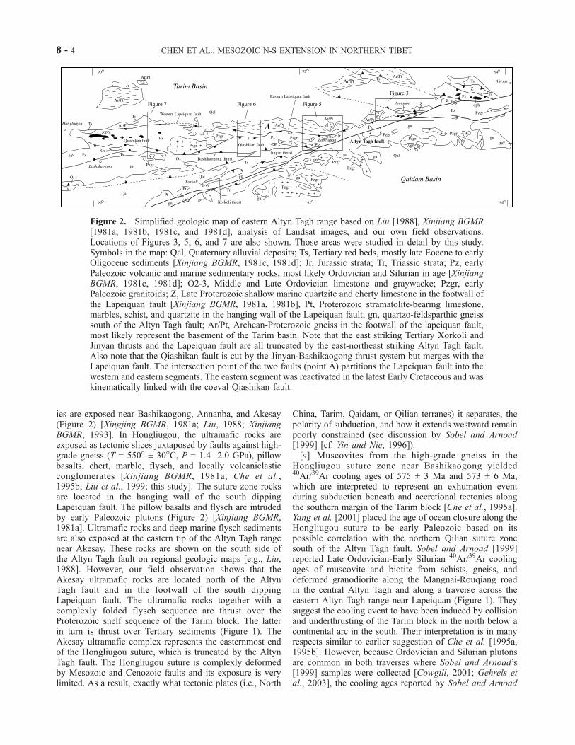
ies are exposed near Bashikaogong, Annanba, and Akesay(Figure 2) [Xingjing BGMR, 1981a; Liu, 1988; XinjiangBGMR, 1993]. In Hongliugou, the ultramafic rocks areexposed as tectonic slices juxtaposed by faults against high-grade gneiss (T = 550� ± 30�C, P = 1.4–2.0 GPa), pillowbasalts, chert, marble, flysch, and locally volcaniclasticconglomerates [Xinjiang BGMR, 1981a; Che et al.,1995b; Liu et al., 1999; this study]. The suture zone rocksare located in the hanging wall of the south dippingLapeiquan fault. The pillow basalts and flysch are intrudedby early Paleozoic plutons (Figure 2) [Xinjiang BGMR,1981a]. Ultramafic rocks and deep marine flysch sedimentsare also exposed at the eastern tip of the Altyn Tagh rangenear Akesay. These rocks are shown on the south side ofthe Altyn Tagh fault on regional geologic maps [e.g., Liu,1988]. However, our field observation shows that theAkesay ultramafic rocks are located north of the AltynTagh fault and in the footwall of the south dippingLapeiquan fault. The ultramafic rocks together with acomplexly folded flysch sequence are thrust over theProterozoic shelf sequence of the Tarim block. The latterin turn is thrust over Tertiary sediments (Figure 1). TheAkesay ultramafic complex represents the easternmost endof the Hongliugou suture, which is truncated by the AltynTagh fault. The Hongliugou suture is complexly deformedby Mesozoic and Cenozoic faults and its exposure is verylimited. As a result, exactly what tectonic plates (i.e., North
China, Tarim, Qaidam, or Qilian terranes) it separates, thepolarity of subduction, and how it extends westward remainpoorly constrained (see discussion by Sobel and Arnoad[1999] [cf. Yin and Nie, 1996]).[9] Muscovites from the high-grade gneiss in the
Hongliugou suture zone near Bashikaogong yielded40Ar/39Ar cooling ages of 575 ± 3 Ma and 573 ± 6 Ma,which are interpreted to represent an exhumation eventduring subduction beneath and accretional tectonics alongthe southern margin of the Tarim block [Che et al., 1995a].Yang et al. [2001] placed the age of ocean closure along theHongliugou suture to be early Paleozoic based on itspossible correlation with the northern Qilian suture zonesouth of the Altyn Tagh fault. Sobel and Arnoad [1999]reported Late Ordovician-Early Silurian 40Ar/39Ar coolingages of muscovite and biotite from schists, gneiss, anddeformed granodiorite along the Mangnai-Rouqiang roadin the central Altyn Tagh and along a traverse across theeastern Altyn Tagh range near Lapeiquan (Figure 1). Theysuggest the cooling event to have been induced by collisionand underthrusting of the Tarim block in the north below acontinental arc in the south. Their interpretation is in manyrespects similar to earlier suggestion of Che et al. [1995a,1995b]. However, because Ordovician and Silurian plutonsare common in both traverses where Sobel and Arnoad’s[1999] samples were collected [Cowgill, 2001; Gehrels etal., 2003], the cooling ages reported by Sobel and Arnoad
Figure 2. Simplified geologic map of eastern Altyn Tagh range based on Liu [1988], Xinjiang BGMR[1981a, 1981b, 1981c, and 1981d], analysis of Landsat images, and our own field observations.Locations of Figures 3, 5, 6, and 7 are also shown. Those areas were studied in detail by this study.Symbols in the map: Qal, Quaternary alluvial deposits; Ts, Tertiary red beds, mostly late Eocene to earlyOligocene sediments [Xinjiang BGMR, 1981c, 1981d]; Jr, Jurassic strata; Tr, Triassic strata; Pz, earlyPaleozoic volcanic and marine sedimentary rocks, most likely Ordovician and Silurian in age [XinjiangBGMR, 1981c, 1981d]; O2-3, Middle and Late Ordovician limestone and graywacke; Pzgr, earlyPaleozoic granitoids; Z, Late Proterozoic shallow marine quartzite and cherty limestone in the footwall ofthe Lapeiquan fault [Xinjiang BGMR, 1981a, 1981b], Pt, Proterozoic stramatolite-bearing limestone,marbles, schist, and quartzite in the hanging wall of the Lapeiquan fault; gn, quartzo-feldsparthic gneisssouth of the Altyn Tagh fault; Ar/Pt, Archean-Proterozoic gneiss in the footwall of the lapeiquan fault,most likely represent the basement of the Tarim basin. Note that the east striking Tertiary Xorkoli andJinyan thrusts and the Lapeiquan fault are all truncated by the east-northeast striking Altyn Tagh fault.Also note that the Qiashikan fault is cut by the Jinyan-Bashikaogong thrust system but merges with theLapeiquan fault. The intersection point of the two faults (point A) partitions the Lapeiquan fault into thewestern and eastern segments. The eastern segment was reactivated in the latest Early Cretaceous and waskinematically linked with the coeval Qiashikan fault.
8 - 4 CHEN ET AL.: MESOZOIC N-S EXTENSION IN NORTHERN TIBET

[1999] most likely reflect the time of plutonic emplacementinstead of a collisional event as envisaged by these authors.As will be discussed below, the cooling history of theeastern Altyn Tagh range is complex. In addition to Ordo-vician-Silurian cooling events, Jurassic and Cretaceouscooling ages of muscovite, biotite, and K-feldspar are alsocommon. Their geologic significance has just begun to beunderstood in light of a structural framework established bythis study.[10] Because the Altyn Tagh fault offsets the Paleozoic
Kunlun batholith belt for �500 km [e.g., Peltzer andTapponnier, 1988; Cowgill, 2001], Yin and Nie [1996]proposed the Qilian suture to have been offset to the centralAltyn Tagh range that separates Tarim into the northern andsouthern blocks. This proposal appears to be at odds withthe observation that Ordovician marine strata are continuousacross the projected suture [Jia, 1997]. To resolve thisproblem, Guo et al. [2001] suggest instead that oceanclosure in central Tarim occurred in the late Proterozoic.This is based on Sm-Nd dating of gabbro and basalt fromthe Hongliugou suture zone that yields an isochron age of829 ± 60 Ma for a gabbro sample and an age of 949 ± 62 Mafor a mix of gabbro and basalt. We believe that these agesonly present the age of the oceanic crust consumed by thesuture and should not be interpreted as indicating the time ofsuturing. Therefore, where is the Qilian suture zone north ofthe Altyn Tagh fault and how it extends into the Tarim basinand beyond to the west remain unresolved.[11] Another inferred suture zone in the Altyn Tagh range
is the Jianglisai-Washixia belt (Figure 1), which is markedby the presence of ultramafic fragments and eclogite-bear-ing high-grade gneiss complexes [Liu et al., 1997]. Theconditions for the formation of the eclogite are P = 1.40–1.85 GPa and T = 660�–830�C as estimated by Liu et al.[1997] and P = 1.1–1.4 GPa and T = 670�–800�C asestimated by Zhang et al. [2001], respectively. The Sm-Ndisotopic data from the eclogite in the inferred suture yield awhole rock-garnet-omphacite isochron of 500 ± 10 Ma, andU-Pb zircon ages of 504 ± 5 Ma [Zhang et al., 2001]. Theseages were interpreted by the above authors to represent theage of suturing in the western Altyn Tagh. Similar to theproblem of the Hongliugou suture, how the Jianglisai-Washixia suture extends westward beneath the CenozoicTarim basin is unclear.
3. Geology of the Lapeiquan Normal
Fault System
[12] A prominent fault that separates Archean-Proterozo-ic gneiss (Unit Ar/Pt in Figure 2) and a late Proterozoicshallow-marine sequence (Unit Z in Figure 2) from Paleo-zoic volcanic and sedimentary rocks (Unit Pz in Figure 2) isexposed along the northern margin of the Tibetan Plateau inthe eastern Altyn Tagh range [Liu, 1988; Xinjiang BGMR,1993]. This fault, referred to as the Lapeiquan fault by theChinese State Bureau of Seismology (CSBS) [1992], extendsfor about 300 km from Hongliugou (�90�E) in the west toAnnanba (�93�E) in the east (Figure 1). The Lapeiquanfault is truncated by the Altyn Tagh fault in the east and
extends beneath Quaternary sediments of the Tarim basin inthe west (Figure 2). In the existing 1:200,000 geologic maps[Xinjiang BGMR, 1981a, 1981b, 1981c, 1981d, 1986], theLapeiquan fault has been consistently shown as a northdipping thrust, putting the Archean-Proterozoic gneisses ofthe Tarim basement [Che and Sun, 1996] over the Paleozoicvolcanic and sedimentary strata [Liu, 1988]. However, ourgeologic mapping and structural observations across thisfault indicate that the fault is south dipping and normal-slip.In the following sections, we describe the characteristics ofthis fault system along four traverses.
3.1. Annanba Area
[13] The Lapeiquan fault in this area is well exposed southof Annanba and dips 30�–40� to the south. Its fault zone isbest exposed along a river cut south of Annanba. It con-sists of 30–50 m thick zone of fine-grained fault gouge andcm-scale highly sheared blocks of siltstone, metavolcanicrocks, and limestone. The volcanic rocks in the hanging wallare locally juxtaposed with ultramafic fragments that may bepart of the Hongliugou suture zone [Xinjiang BGMR, 1981b,1981c]. Bedding in the sheared rock fragments in the faultzone is variably discordant with shear surfaces due tofracturing and rotation. At one location the sense of rotatedclasts in the fault zone indicates a down-to-the-south sense ofmotion. Due to extensive development of fine-grained faultgorge, striations are poorly development. As a result, wewere not able to carry out a detailed kinematic study of thefault zone at this location. On map view, the eastern end ofthe east striking Lapeiquan fault is truncated by the activenorth-northeast striking left-slip Altyn Tagh fault and mayhave been offset for more than 250 km [Yin et al., 2000].[14] The age of the hanging wall sequence was first
assigned as late Proterozoic [Xinjiang BGMR, 1981b],although neither fossils nor radiometric ages were provided.The same lithologic sequence near Lapeiquan along strikeimmediately to the west of the Annanba area was assignedto be Late Ordovician as indicated by the presence ofmarine fossils [Xinjiang BGMR, 1981d]. Based on thisinformation, we interpret the age of the rocks directly abovethe Lapeiquan fault to be early Paleozoic.[15] The footwall rocks of the Lapeiquan fault in the
Annanba area are a sequence of shallow marine quartziteand cherty limestone. The sequence dips gently to the north.Both ripple marks and cross-beddings are abundant in thepurple quartzite layers, whereas limestone beds containstromatolite and cm-scale cherty layers (Figure 4a). Highlyaltered mafic sills intruding cherty limestone were alsoobserved in the field. The age of the footwall sequencehas been assigned to be Late Proterozoic based on thepresence of stromatolite [Xinjiang BGMR, 1981b]. To thewest, the Annanba Late Proterozoic sedimentary sequenceis unconformably on top of the Archean-Proterozoicgneisses (Figure 4b). This contact was originally mappedas a fault by Xinjiang BGMR [1981c]. The contact betweenthe crystalline basement and Proterozoic sedimentarysequence is truncated by the Lapeiquan fault (Figure 3),indicating that the Lapeiquan fault cuts progressively deepercrustal section westward and its vertical stratigraphic throw
CHEN ET AL.: MESOZOIC N-S EXTENSION IN NORTHERN TIBET 8 - 5

decreases eastward (Figure 2). Although we did not performdetailed kinematic analysis of fault zone deformation, theyounger-over-older field relationship and relatively low-angle dip of the fault zone are suggestive of normal sensemotion along this segment of the Lapeiquan fault.[16] An active north dipping thrust immediately north of
Annanba repeats the Late Proterozoic stratigraphic sectionand tilted a Quaternary alluvial fan northward (Figure 3).The development of this thrust is related to the presence of alarge restraining bend along the active Altyn Tagh faultsystem that produces two strands in this area (Figure 2).Both strands strike east and depart significantly from itsregional strike of N65�E (Figure 2). Several minor thrustswith offset of <50 cm are observed in the limestone beds inthe footwall of the active thrust.
3.2. Lapeiquan Area
[17] The south dipping Lapeiquan fault in this areajuxtaposes early Paleozoic volcanic and sedimentary rocks,Carboniferous limestone and shale, and Lower and Mid-dle Jurassic strata over Archean and Proterozoic gneisses(Figure 4). Our age assignment of the lithologic unitsfollows that of Xinjiang BGMR [1981d, 1993] and Cheand Sun [1996]. Footwall rocks of the fault consist offoliated diorite that were intruded first by K-feldspar richgranite followed by intrusion of west-northwest trendingmafic dike swarms. The dikes are truncated in the east bythe Lapeiquan fault. Foliation in the footwall gneisses isfolded both at an outcrop scale as isoclinal folds (a fewmeters of wavelengths and amplitudes) and as broad east-plunging antiforms and synforms (5–6 km wavelength and1–2 km amplitude) at a map scale (Figure 5).[18] The Lapeiquan fault dips �30� to the south. Locally,
its dip can be as low as �15�. Where exposed, the fault isexpressed as a �2-m thick zone of yellow fault gouge. In
two places we observed striations on the fault surface, onetrending to the south and plunge at 15� and another trendingS30�W and plunge at 35�. The crystalline rocks below theLapeiquan fault exhibit little brittle deformation. Weobserved no mylonite associated with the fault at thislocation. Immediately above the fault is the Upper Ordovi-cian volcanic strata interbedded with limestone, shale, andgraywacke [Xinjiang BGMR, 1981d] (Figure 5). Bedding ofthis unit directly above the fault defines numerous small-scale asymmetric folds (10–20 cm wavelength and 5–10cm in amplitude), all verging to the south. In addition,mesoscopic-scale faults that are directly above and parallelto the Lapeiquan fault have offsets of a few centimeters totens of centimeters and show consistent top-south normalslip (Figure 4c). We relate the development of smallasymmetric folds and hanging wall minor normal faults tomotion along the Lapeiquan fault. The correlation suggeststhat the fault is normal-slip.[19] Structures south of the Lapeiquan fault are charac-
terized by two oppositely dipping Tertiary thrusts: the northdipping Jinyan thrust in the and the south dipping Xorkolithrust in the south (Figure 2). The contacts represented bythe Jinyan and Xorkoli thrusts were originally mapped asunconformities between Tertiary strata above and Precam-brian and Paleozoic strata below [Xinjiang BGMR, 1981d;Liu, 1988; Xinjiang BGMR, 1993]. The age of the Tertiarybasin bounded by the thrusts is Eocene-early Oligocenebased on preserved fossils in the strata [Xinjiang BGMR,1981d]. The basin development is most likely related tomotion along the two bounding thrusts, suggesting that theJinyan and Xorkoli thrusts are Eocene-Oligocene in age.The inferred Paleogene age for the Jinyan thrust is consis-tent with the field observation that the fault is folded and istherefore no longer active (Figure 5).[20] The hanging walls of the two Paleogene thrusts
consist of garnet-bearing Proterozoic schist and marbles,
Figure 3. Simplified geologic map of the Annanba area based on our reconnaissance mapping, analysisof Landsat images, and reinterpretation of the existing geologic maps at a scale of 1:200,000 and 1:1.5 M[Xinjiang BGMR, 1981b, 1981c, 1986; Liu, 1988]. Note that the Lapeiquan fault cuts deeper crustalsection westward. It is truncated in the east by the active Altyn Tagh fault.
8 - 6 CHEN ET AL.: MESOZOIC N-S EXTENSION IN NORTHERN TIBET

Ordovician volcanic and sedimentary rocks, Carboniferouslimestone, and Jurassic conglomerates. As discussed below,the Lapeiquan fault is a Mesozoic normal fault. Thus, theTertiary thrusts in the Lapeiquan area are interpreted to cutthe Lapeiquan fault at depth on cross-sectional view(Figure 5). The Tertiary thrusts are in turn truncated bythe younger left-slip Altyn Tagh fault in the east (Figure 5).The timing, evolution, and regional implication of thetruncational relationship between the Tertiary thrust belt inthe eastern Altyn Tagh range and the Altyn Tagh fault was
briefly mentioned in Yin and Harrison [2000] and will bediscussed fully elsewhere.[21] The Lower and Middle Jurassic sedimentary rocks of
Xinjiang BGMR [1981d] in the hanging wall of the Lapei-quan fault is a fining upward sequence consisting ofconglomerate, course grained sandstone, siltstone, andcoal-bearing shale. The contact between the Jurassic strataand the Ordovician volcanics is an angular unconformity.The Ordovician strata below are folded with amplitudes of30–50 m and wavelengths of 30–50 m. Folds are best
Figure 4. Field relationships. (a) Proterozoic stramatolite-bearing, cherty limestone in Annanba in thefootwall of the Lapeiquan fault; see Figure 3 for location. (b) Sketch of unconformity betweenProterozoic strata and Precambrian basement based on photo; see Figure 3 for location. (c) Minor normalfaults and south verging asymmetric folds in Ordovician volcanic rocks directly above the Lapeiquanfault; see Figure 5 for location. (d) Jurassic basal conglomerates immediately above the unconformity.Dark gray colored cobbles are derived from the underlying Ordovician volcanic rocks, whereas white andpurple colored cobbles are quartzite that match the lithology of Annanba Proterozoic sequence in thefootwall of the Lapeiquan fault. See Figure 5 for location. (e) Jurassic strata directly above Figure 4d withclasts of stramatolite-bearing cherty limestone and purple quartzite. They match the lithology of AnnanbaProterozoic sequence. The section is younging to the left (east). Note that the imbricated pebbles showsouthward paleocurrent direction. See Figure 5 for location. (f) Jurassic strata directly above exposure inFigure 4e. The clasts and cobbles are dominated by stramatolite-bearing limestone. See Figure 5 forlocation. (g) Asymmetric boudinages in the Lapeiquan ductile shear zone in the Kaladawan area; seeFigure 6 for location. (h) Small conjugate normal faults above the south dipping Qiashikan fault in theKaladawan area. See Figure 6 for location.
CHEN ET AL.: MESOZOIC N-S EXTENSION IN NORTHERN TIBET 8 - 7

defined by the easily traceable massive blue limestone layers.The basal Jurassic conglomerate is about 50–60 m thick. Inthe lower 10–20 m section, it is dominated by cobbles ofOrdovician volcanics with rare purple quartzite and strama-tolite-bearing limestone (Figures 4d, 4e, and 4f ). The amountof Ordovician volcanic clasts decreases rapidly up-section.At about 30–40 m above the basal contact, cobbles aredominated by cherty limestone, purple quartzite, and stra-matolite-bearing limestone, all are characteristic for theAnnanba shallow marine sequence (Figure 4d). Preliminaryobservations of pebble imbricates in this part of the Jurassicsection indicate that the paleocurrent directionwas fromnorthto south (Figure 4e), which is consistent with the correlationbetween Jurassic clasts and Proterozoic strata in the Annanbaarea. However, at the top part of the 70-100 m conglomeratesection, imbricate pebbles also indicate northward paleocur-rent direction where volcanic clasts dominate again.[22] The topmost part of the basal conglomerate sequence
consists of a large landslide block, which is at least 200-mlong and 20-m thick. The block is composed of a highly
shattered gabbro body and relatively coherent basalticlayers. The landslide block, enclosed by Jurassic strata,could have been part of the Hongliugou suture that hasbeen exhumed by the Lapeiquan fault in its footwall. Thedeposit of the landslide indicates significant topographicrelief in the region at the time of Jurassic deposition. Theabove observations support the interpretation that the Ju-rassic strata in the Lapeiquan area were deposited duringmotion along the Lapeuiquan fault and extension in itshanging wall. This implies that the Lapeiquan fault wasactive in the Early Jurassic.[23] Above the basal conglomerate that dips at 70�–80�S
is a sequence of �200-m thick sandstones and shale that dip10�–15� shallower. We interpret the upward shallowing inbedding dip to be induced by deposition of growth strata ina half graben, which was in turn controlled by a northdipping normal fault in the hanging wall of the Lapeiquanfault (Figures 5b and 5c). This interpretation can be testedby more detailed sedimentologic studies in the future. Wecannot rule out the possibility that shallowing of Jurassicstrata was induced by younger folding.
3.3. Kaladawan Area
[24] The Lapeiquan fault is most spectacularly exposed inthis area. The fault zone is expressed by a 60–80-m thickductile shear zone that juxtaposes an Early Paleozoic granite[Xinjiang BGMR, 1981d] in the hanging wall and anArchean-Proterozoic gneissic complex in the footwall[Che and Sun, 1996] (Figure 6). The Precambrian crystal-line rocks consist of metabasite, foliated granite, andquartzo-feldspathic gneiss that are locally intruded by rareundeformed Paleozoic (?) granitic dikes (a few meters wideand tens of meters long). Granites in the hanging wallintrude into a sequence of basalt, andesite, marble, andgraywacke which have been assigned an Early Paleozoicage [Xinjiang BGMR, 1981d]. The graywacke sequence isfolded along east trending axes and its bedding is locallytransposed by axial cleavage. South of the Lapeiqaun faultlies the Jinyan thrust that splits into two branches: itsnorthern strand links with the Bashikaogong thrust to thewest whereas its southern strand is covered by Quaternaryalluvial fan deposits (Figure 2). Although the westernsegment of the Jinyan thrust puts Paleozoic strata overTertiary sedimentary sequence, its western segment in theKaladawan area juxtaposes younger Paleozoic graywackeunit over the older Proterozoic stramatolite-bearing marble(Figures 2 and 6). This unusual younger-over-older rela-tionship suggests that the Tertiary Bashikaogong thrust mayhave originated either from an out-of-sequence thrust orfrom a north dipping normal fault that was later inverted tobecome a thrust. If the latter interpretation is correct, theJinyan thrust could have been the inferred north dippingnormal fault responsible for the deposition of the southwardshallowing Jurassic strata in the Lapeiquan area (Figure 5c).[25] The mylonitic shear zone immediately below the
Lapeiquan fault consists of mylonitized marble, muscovite-biotite schist, and highly stretched granitoid boudins withina muscovite-biotite schist unit. Foliations strike east-westand dip at 60�–45�S. Stretching lineations are defined by
Figure 4. (continued)
8 - 8 CHEN ET AL.: MESOZOIC N-S EXTENSION IN NORTHERN TIBET

Figure 4. (continued)
CHEN ET AL.: MESOZOIC N-S EXTENSION IN NORTHERN TIBET 8 - 9

streaky quartz and broken plagioclase. Their trend is veryclose to the down-dip direction of the foliation (Figure 6b).The asymmetric boudinage consistently shows a top-southsense of shear (Figure 4g).[26] In the hanging wall of the Lapeiquan fault, a south
dipping fault, referred here as the Qiashikan normal fault inthis study area, was mapped by Xinjiang BGMR [1981d]that puts an early Paleozoic graywacke sequence over anearly Paleozoic granitoid (Figures 2 and 6). Along thetraverse we investigated, the fault mapped by XinjiangBGMR [1981d] is covered by a wash. Thus, we were notable to directly examine the kinematics of the fault.However, directly south of and above the inferred fault,mesoscopic normal faults are present in the graywackeunits (Figure 4h). The concentration of small normal faultsnear the Qiashikan fault immediately south of its traceimplies that the latter is probably an extensional structure.Based on the existing geologic map [Xinjiang BGMR,1981d], knowledge of lithologic units in the mapped area,and the analysis of Landsat images, we interpret that theQiashikan fault merges to the east with the Lapeiquan fault(Figure 6). The Qiashikan fault can be traced to the west tothe Qiashikansayi area where the kinematic indicators in
the fault zone suggest it to be a normal fault (Figures 7aand 7b).
3.4. Qiashikansayi Area
[27] The easternmost exposure of the Lapeiquan fault wasexamined along the Qiashikansayi creek near Bashikaogong(Figures 2 and 7). The Lapeiquan fault here is defined by acataclastic shear zone (>50 m thick) dipping �30�–40� tothe south. Its hanging wall consists of a sequence of foldedvolcanic, sedimentary, and metamorphic rocks. On the basisof lithology and the structural style we divide this study areainto three geologic domains. The northern domain liesbetween the Lapeiquan normal fault in the north and thesouth dipping North Qiashikan thrust in the south. Itconsists dominantly of basalts interlayered with marbleand quartzite beds. Locally conglomerates characterizedby locally derived basaltic cobbles are also present. Thisunit is broadly folded. Bedding in this domain was trans-posed in places by the development of axial cleavage. Thefolded section is locally intruded by east trending maficdikes of unknown age (Figures 7a and 7b). The NorthQiashikan thrust juxtaposes a garnet-bearing gneissic unit
Figure 5. (a) Geologic map of the Lapeiquan area based on our own geologic mapping at a scale of1:100,000. See legends for map symbols. Location of Figure 5 is shown in Figure 2. (b) Geologic crosssection (A-B) across the Lapeiquan area. (c) Schematic cross section showing possible relationshipbetween Jurassic growth strata and Lapeiquan extensional fault system.
8 - 10 CHEN ET AL.: MESOZOIC N-S EXTENSION IN NORTHERN TIBET

over a sequence of north vergent isoclinal folds composedof find-grained sandstone and shale. The age and themagnitude of the North Qiashikan thrust are unknown.[28] The central domain of the Qiashikansayi area con-
sists of high-grade gneiss [Che et al., 1995b; Liu et al.,1999] and a melange complex that consists of ultramaficbodies [Xinjiang BGMR, 1986], abundant ribbon chert, andpillow basalts. The melange complex is presumably a partof the Hongliugou suture zone, first described by Che et al.[1995a, 1995b] and was extensively discussed later in thecontext of regional tectonics by Sobel and Arnoad [1999].The boundary between the high-grade gneiss and themelange is a high-angle, south dipping ductile shear zone,here referred to as the Qiashikan normal fault. As shown bythe existing geologic map [Xinjiang BGMR, 1981d, 1986]and via the analysis of Landsat images, this normal fault canbe traced to the Kaladawan area where it merges with theLapeiquan fault (Figures 2, 6, and 7).
[29] Directly below the south dipping Qiashikan nor-mal fault is a �200-m thick zone of mylonitic gneisses(Figures 7a and 7b). The attitudes of the mylonitic foliationsand lineations change systematically. Directly below thefault, the mylonitic foliation strikes east and dips steeply tothe north. The corresponding lineations trend northwest. S-C fabrics indicate north-side-up and right-slip sense ofshear. Further to the north, the mylonitic shear zone isdominated by south dipping foliations and south-plungingstretching lineations with down-to-the-south sense of shearas indicated by asymmetric folds, S-C fabrics, and enechelon quartz veins within the mylonitic gneiss. Thelithologic units in the northern and central domains acrossthe Qiashikan normal fault are similar, which are dominatedby a basaltic sequence interbedded with limestone, mud-stone, and siltstone (unit Pzb in Figures 7a and 7b). Thisduplication could have been caused by slip along either theQiashikan normal fault or the North Qiashikan thrust.
Figure 5. (continued)
CHEN ET AL.: MESOZOIC N-S EXTENSION IN NORTHERN TIBET 8 - 11

Figure 6. (a) Geologic map of the Kaladawan area and (b) stretching lineations of the myloniticgneisses directly below the Lapeiquan fault. (c) Geologic cross section (C-D) of the Kaladawan area.
8 - 12 CHEN ET AL.: MESOZOIC N-S EXTENSION IN NORTHERN TIBET

Figure 7a. Geologic map of the Qiashikansayi area.
CHEN ET AL.: MESOZOIC N-S EXTENSION IN NORTHERN TIBET 8 - 13

[30] The southern domain of the Lapeiquan hanging wallis a pop-up structure between the south dipping NorthBashikaogong thrust and the north dipping Bashikaogongthrust. Both faults are Tertiary structures. This domainconsists of a sequence of metavolcanic rocks, dominantlyrhyolite and andesite that are intruded by small granitoids(Figure 7). The volcanic rocks were broadly assigned asearly Paleozoic in age [Xinjiang BGMR, 1986]. The foot-wall rocks of the Bashikaogong thrust consist of a sequenceof Devonian sandstone and shale intruded by a granitoid. Asliver of Jurassic strata is sandwiched between the NorthBashikaogong thrust in the south and a brittle high-anglefault in the north (Figure 7). The Jurassic strata dip steeplyto the south (50�–75�) and consist of �100-m thickconglomerate below and 20–30 m thick coarse-grainedsandstone. The clasts in the Jurassic strata are dominatedby volcanics and purple quartzite. The former can becorrelated with the Early Paleozoic volcanic rocks alongthe Qiashikansayi transect. The purple quartzite is charac-teristic of the Proterozoic cover sequence of the Tarimbasement as we described in the Annanba area. Becauseof this correlation, we suggest that the Jurassic basin inthe Qiashikansayi area also records unroofing history ofthe Tarim block in the footwall of the Lapeiquan fault. Thesimilar dip direction and clast composition suggest that theJurassic strata in the Qiashikansayi area may have beendeposited in the same basin as Jurassic strata in theLapeiquan area.[31] The high-angle fault on the north side of Jurassic
strata dips steeply to the southwest (�70�) and is truncatedby the Bashikaogong thrust at its eastern end. At onelocation, this fault is vertical and strikes N70�W. Striations
on the fault surface plunge gently at 11�E. En echelonquartz veins within the fault zone suggest a right-slip senseof shear. From the crosscutting relationship, the right-slipfault here referred to as the South Qiashikan fault, wesuggest that fault was active after deposition of the Jurassicstrata and prior to the activation of the Tertiary Bashikao-gong thrust. The South Qiashikan fault is similar to theQiashigan fault in their geometry and kinematics. Both dipsteeply to the south and both have right-slip sense ofmotion. It is possible that the two faults were developedcoevally.[32] In the Qiashikansayi area, the Lapeiquan fault is
characterized by a 10-20 m thick zone of cataclasticdeformation. Because of the presence of well-developedfault gouge in the fault zone, striations are poorly devel-oped. Directly below the fault zone is a tabular-shapedearly Paleozoic granitoid, 100–120 m thick, which isextensively fractured and sheared. The granitoid may be asliver in the fault zone (Figures 7a and 7b). Below thegranitoid is a schist unit, assigned as Precambrian in age byXinjiang BGMR [1986]. Well-developed foliation in theschist unit dips gently to the south (30�–40�), parallel tothe dip of the Lapeiquan fault �150 m above. Numeroussmall-scale asymmetric folds (amplitude = 3–5 cm, andwavelength = 5–10 cm) are present within this unit. Thosefolds have east trending hinges parallel to the Lapeiquanfault and show a top-south sense of shear. The schist unit isjuxtaposed against a gneiss unit by a south dipping high-angle brittle fault. We interpret this fault to be a member ofthe south dipping Lapeiquan normal fault system. EarlyTertiary sedimentary strata at the northern end of ourmapped area rest unconformably over the Precambrian
Figure 7b. Geologic cross section of the Qiashikansayi.
8 - 14 CHEN ET AL.: MESOZOIC N-S EXTENSION IN NORTHERN TIBET

gneiss [Xinjiang BGMR, 1986]. The unconformity and theoverlying early Tertiary strata dip gently to the north[Xinjiang BGMR, 1986], indicating the Lapeiquan faultand its footwall to have been tilted northward since earlyTertiary. The kinematic indicators in the schist unit men-tioned above and the observation that unmetamorphosedsedimentary and volcanic rocks overlying high-grade schistand gneiss support the interpretation that the Lapeiquanfault was an extensional structure.
4. Geochronology
[33] In order to better constrain the timing of slip alongthe Lapeiquan fault we have determined the crystallizationages and low-temperature thermal histories of several sam-ples in the footwall. Ion microprobe U-Pb dating of zirconand 40Ar/39Ar dating of hornblende were performed toconstrain crystallization ages while 40Ar/39Ar step-heatingof K-feldspar yielded thermal history data. Tabulated resultsof the isotopic measurements and details of the analyticalmethods employed are available as auxiliary material1.
4.1. U-Pb Geochronology
[34] Measurements were performed on three granitoidsamples from the footwall of the Lapeiquan fault (AY6-10-99-(7), AY6-3-99-14, and AY6-1-99-(4)). A forth spec-imen (99DP2-1) yielded insufficient zircons for analysis.All errors quoted are ±1s analytical uncertainties. Based onrepeated analysis of AS-3 standard zircon (1099 Ma [Pacesand Miller, 1993]) during the analysis of the above samples,our expectation is that their U-Pb age could be determinedwith a precision of better than 2.5% provided that they werehomogeneous in age and contained uranium concentrationsthat were comparable to AS-3 (�550 ppm).[35] Sample AY6-10-99-(7) was collected from the highly
fractured granitoid directly below the Lapeiquan fault in theQiashikansayi area (Figure 7a). Five spots measured on fivegrains yielded essentially concordant ages between ca.400–430 Ma (Figure 8a). The weighted mean 206Pb/238Uand 207Pb/235U ages calculated from these results are 418 ±8 Ma and 402 ± 16 Ma, respectively. We interpret theseresults to closely approximate the intrusive age of thisgranitoid and point out that its age is similar to thosedetermined for other Paleozoic igneous rocks exposed alongthe Altyn Tagh fault to the southwest [Cowgill, 2001].[36] Sample AY6-3-99-14 from the Kaladawan area (Fig-
ure 6a) yielded a more complex result. The sample islocated about 200 m below the Lapeiqaun fault and repre-sents an undeformed granitoid dike intruded into Protero-zoic metasedimentary and metavolcanic rocks. Five spotanalyses from five grains yielded a wide range of discordantresults between 100–415 Ma (Figure 8b). We interpret thisdispersion of U-Pb ages to have resulted from Pb loss andnote that the oldest age obtained was approximately con-
cordant at 413 ± 7 Ma. The age similarity of this result tothe crystallization age determined for sample AY6-10-99-(7)indicates the likelihood that the granitic dike is also part of awidespread early Paleozoic intrusive sequence in northernTibet [Cowgill, 2001]. The presence of Paleozoic granites inthe footwall of the Lapeiquan fault is a new discovery,because the age of this terrane was previously regarded lateArchean. The lack of Paleozoic plutons in the Tarim base-ment has been used as evidence for the presence of a southdipping subduction zone in the early Paleozoic [Sobel andArnoad, 1999]. However, our results appear to be inconsis-tent with this simple model.[37] The final sample, AY6-1-99-(4), was collected im-
mediately adjacent to the Lapeiquan fault from a graniticgneiss as part of the Precambrian basement rocks in thefootwall (Figure 4a). Spot analyses obtained from zircons inthis specimen are also widely dispersed and discordant in amanner consistent with a discrete episode of Pb loss(Figure 8c). A best fit line to all data points yields a well-defined upper intercept of 1815 ± 12 Ma with concordia.The lower intercept of the array of U-Pb results from AY6-1-99-(4) (133 ± 15 Ma) is slightly older than the time ofrapid cooling recorded by coexisting K-feldspar (see nextsection). We also analyzed hornblende from a lithologicallysimilar sample (AY8-21-98-2A) situated about 12 km northof the Lapeiquan fault (Figure 4). The total gas age yieldedby this sample, 1767 ± 3 Ma (see next section), is onlyslightly younger than the upper intercept U-Pb age deter-mined for zircons from AY6-1-99-(4).
4.2. 40Ar/39Ar Thermal History Results
[38] A total of five K-feldspars from the footwall of theLapeiquan fault were step-heated by the 40Ar/39Ar methodto determine cooling histories immediately adjacent to, anddistal from the fault (Figure 9). The results were interpretedusing the multi-diffusion domain (MDD) model [Lovera etal., 1989] using the assumption of slow-cooling. Theapproach employed is discussed by Lovera et al. [1997].Details of the modeling process employed with the samplesexamined in this paper employed can be obtained from theelectronic supporting material. Note that in the case ofsample AY9-21-98-2A (Figure 9i), it was necessary tocorrect for the initial portion of its age spectrum for Cl-correlated excess radiogenic 40Ar [Harrison et al., 1994].While the other samples did not require such treatment,other features of their age spectra are problematic andrequire detailed discussion.[39] Many, though not all, K-feldspars sampled within
high-strain zones proximal to faults exhibit intermediate agemaxima that signal partial failure of the underlying assump-tions of the MDD model and hence limit detailed interpre-tation of thermal histories obtained from them [Lovera etal., 2002]. All five samples obtained adjacent to theLapeiquan fault exhibit these features (see Figures 9a, 9c,9e, 9g, and 9i). The most prominent example is yielded byAY6-3-99-14 K-feldspar (Figure 9e). The possible originand significance of intermediate age maxima in K-feldsparage spectra are discussed in Lovera et al. [2002]. While thistopic is beyond the scope of this paper, it is most important
1 Auxiliary material is available via Web browser or via AnonymousFTP from ftp://ftp.agu.org/apend/tc/2001TC001336. Information on search-ing and submitting electronic supplements is found at http://www.agu.org/pubs/esupp_about.html.
CHEN ET AL.: MESOZOIC N-S EXTENSION IN NORTHERN TIBET 8 - 15

to point out that the existence of the features limits ourability to accurately recover thermal histories from thesamples. In spite of this limitation, the unaffected portionsof the age spectra are quite simple to interpret and we haveproceeded on these grounds.[40] Three K-feldspars obtained from Paleozoic gran-
itoids distributed along the western portion of the Lapeiquanfault yield broadly similar results. These include samples99DP2-1 and AY6-3-99-14 from the Kaladawan area (Fig-ure 6a) and AY6-10-99-(7) from the Qiashikansayi area(Figure 7a). All three samples reveal pronounced agegradients between 100-200 Ma and flat age spectra at hightemperature stages of cumulative 39Ar release defined by ca.186 Ma ages for sample 99DP2-1 (Figure 9a) and circa220 Ma ages for samples AY6-10-99-(7) (Figure 9c) and
AY6-3-99-14 (Figure 9e). In applying the MDD modelapproach to these samples, we neglected the intermediateage maximum that typically affects the age spectrumbetween about 15–25% cumulative 39Ar release and as-sumed monotonic cooling. The resulting thermal histories,represented by 90% confidence intervals for the mean of 50best fit solutions, are shown in Figures 9b, 9d, 9f, 9h, and9j, respectively. The corresponding best fit age spectra areshown in Figures 9a, 9c, 9e, 9g, and 9i. Despite the fact thatdetailed interpretation of the thermal history results is likelyto be problematic, we are struck by the similarity of theresults and suggest that it is likely that all samples experi-enced rapid cooling to below 200�C between 220–185 Maand slower cooling at upper crustal levels for the next 80 m.y.[41] Further to the east, two K-feldspars were analyzed
from the Lapeiquan area (Figure 4). As discussed above,both samples were collected from the Precambrian gneisses.The age spectrum obtained from the sample adjacent to theLapeiquan fault, AY6-1-99-(4), yields an age gradient fromca. 30 Ma to 100 Ma over the initial 15% of 39Ar releaseand a flat age spectrum defined by 100 Ma ages thereafter(Figure 9g). Following the same type of analysis outlinedabove, these results indicate rapid cooling to below �175�Cat 100 Ma followed by slow cooling into the Late Oligocene(Figure 9h). Further away from the Lapeiquan fault, sampleAY8-21-98-2A (Figure 9i) indicates protracted slow coolingwithin the middle- to upper crust throughout the Paleozoicand early Mesozoic (Figure 9j). This result is consistentwith the fission track analysis of a sample collected bySobel et al. [2001] near the location of our sample AY8-21-98-2A, who showed that single grain zircons yielded an ageof 221 ± 26 Ma and apatites yielded an age of 167 ± 15 Ma.Hornblende from sample AY8-21-98-2A yielded a total gasage of 1767 ± 3 Ma (see electronic supporting material).Because no major faults lie between samples AY6-1-99-(4)
Figure 8. (opposite) Results of U-Pb dating of zircons.(A) Sample AY6-10-99-(7) from the highly shearedgranitoid directly below the Lapeiquan fault in theQiashikansayi area. Five spots measured on five grainsyielded essentially concordant ages between ca. 400–430 Ma. The weighted mean 206Pb/238U and 207Pb/235Uages calculated from these results are 418 ± 8 Ma and 402 ±16 Ma, respectively. (B) Sample AY6-3-99-14 from theKaladawan area yielded a more complex result. The samplerepresents an undeformed granitoid dike intruded intoProterozoic metasedimentary rocks. Five spot analysesfrom five grains yielded a wide range of discordant resultsbetween 100–415 Ma. We interpret the dispersion ages ofU-Pb ages to have resulted from Pb loss and note that theoldest age obtained was approximately concordant at 413 ±7 Ma. (C) Result from sample AY6-1-99-(4). Spot analysesobtained from zircons in this specimen are widely dispersedand discordant in a manner consistent with a discreteepisode of Pb loss. A best fit line to all data points yields awell-defined upper intercept of 1815 ± 12 Ma withconcordia. The lower intercept (133 ± 15 Ma) is slightlyolder than the time of rapid cooling recorded by coexistingK-feldspar for the same sample.
8 - 16 CHEN ET AL.: MESOZOIC N-S EXTENSION IN NORTHERN TIBET

and AY8-21-98-2A, the contrast in thermal histories(>150�C at 100 Ma) requires that the present exposurelevels of Proterozoic gneiss exposed along the Lapeiquanfault originated from a depth at least 5 km deeper than those10 km to the northeast. This is consistent with our fieldobservation indicating that the south dipping Lapeiquanfault is a normal fault. That is, the fault cuts progressivelydeeper to the south.[42] Total gas ages of biotite are also obtained from this
study, although they all yielded large uncertainties. In theKaladawan area, a biotite age of 351 ± 11 (2s) Ma wereobtained from a gneiss unit in the Lapeiquan hanging wall(AY8-23-98-3b, Figure 6). This is in contrast to a youngerbiotite age of 201 ± 20 (2s) Ma obtained from a Paleozoicdike in the footwall (AY6-3-99-14, Figure 6). The coolingage of biotite in the footwall is similar to the duration ofrapid cooling inferred from K-feldspar analysis. The con-trasting cooling ages of biotite across the fault again supportthe interpretation that the Lapeiquan fault is a normal-slip
structure. In the Qiashikansayi area, a biotite age of 254 ±26 Ma (2s) is obtained from the Paleozoic granite in theLapeiquan footwall (Figures 7a and 7b). This age suggeststhat cooling of the early Paleozoic granite could have startedas early as Early Triassic, which may imply that extensionin northern Tibet may have started earlier than that indicatedby the results of K-feldspar analyses.
5. Discussion
5.1. Timing and Structural Developmentof the Lapeiquan Normal Fault
[43] The most interesting result from the 40Ar/39Ar ther-mochronologic studies is the discovery of two episodes ofrapid cooling in the footwall of the Lapeiquan fault. Thefirst occurred in the early Jurassic at �187–200 Ma alongthe central and western segments of the fault, and thesecond in the latest Early Cretaceous at �100 Ma alongthe eastern segment of the fault. This finding appears to bepuzzling at first, because it requires very different move-ment histories along the same fault. However, this problemcan be resolved when considering the Qiashikan fault as ayounger element of the Lapeiquan fault system. The southdipping Qiashikan fault merges with the Lapeiquan faultjust east of the Kaladawan traverse (Figure 2). This rela-tionship suggests that the eastern segment of the Lapeiquanfault could have moved together with the Qiashikan fault inthe Cretaceous while the western Lapeiquan fault wasinactive. The age of the Qiashikan fault is unknown, butthe above geometrical interpretation on the relationshipbetween the Qiashikan and Lapeiquan faults implies thatthe two must be synchronous. This leads to the possibilitythat the Lapeiquan fault was initially an Early Jurassicnormal fault and was later reactivated by motion alongthe Qiashikan-eastern Lapeiquan fault in the Cretaceous(Figure 10a). Alternatively, the younger Qiashikan faultmay have cut and offset the older Lapeiquan fault(Figure 10b). The lack of prominent faults in the footwallof the eastern Lapeiquan fault, as indicated by the contin-uation of northwest trending dike swarms in the Precam-brian crystalline basement, support the first possibility. If theQiashikan fault is a Cretaceous fault, its magnitude of verticaloffset must be relatively small along the Qiashikansayitraverse. Muscovites from the high-grade gneiss immediatelybelow the Qiashikan normal fault yielded 40Ar/39Ar coolingages of 575 ± 3 Ma and 573 ± 6 Ma [Liu et al., 1999]. Thismeans that the magnitude of Cretaceous normal faulting wasnot sufficient to reset the muscovite cooling ages.[44] The interpretation that the Lapeiquan fault was active
in the Early Jurassic is consistent with the observation thatthe Lower and Middle Jurassic strata in the hanging wall ofthe Lapeiquan fault were deposited in a half-graben basinwith its proximal clasts derived from both its footwall andhanging wall. We also note that Middle Jurassic alkalinebasalts are common in the northern Altyn Tagh area, asrecently reported by Guo et al. [1999] and Zhang et al.[1998] at Tuoge, Duobagou, and Lucaogou localities(Figure 1). The age of the basalts was constrained byinterbedded sedimentary strata which contain plant
Figure 9. Results of multi-diffusion-domain analysis ofK-feldspars using the 40Ar/39Ar step-heating method.Graphics (A), (C), (E), (G), and (I) are measured (solidlines) and modeled (light gray lines) age spectra for samples99DP2-1, AY6-10-99-(7), AY6-3-99-14, AY6-1-99-(4), andAY8-21-99-2A. Graphics (B), (D), (F), (H), and (J) arecalculated cooling histories of the five samples.
CHEN ET AL.: MESOZOIC N-S EXTENSION IN NORTHERN TIBET 8 - 17

Figure 10. Two possible models for the relationship between the Lapeiquan and Qiashikan normalfaults. (A) The Qiashikan fault reactivates the eastern segment of the Early Jurassic Lapeiquan fault in theCretaceous. This model predicts Cretaceous cooling immediately below the footwall of the easternLapeiquan fault as documented by this study. (B) The Qiashikan fault cut and offset the Early Lapeiquanfault in the Cretaceous. This model predicts that Cretaceous cooling history should be recorded in thefootwall of a major fault within the Precambrian gneiss in the footwall of the Lapeiquan fault, which hasnot been observed. (C) Schematic cross section illustrating possible style of Jurassic deformation andsedimentation in northern Altyn Tagh and southern Tarim. Note that Early and Middle Jurassic strata aredeposited in half-grabens controlled by domino-style normal faults.
8 - 18 CHEN ET AL.: MESOZOIC N-S EXTENSION IN NORTHERN TIBET

fossils of Sphenobaierd sp., Cladophlebis sp., and Pityophy-lam sp. The Middle basaltic volcanism in the northern AltynTagh region may be related to extensional event in the easternAltyn Tagh range as we reported here. The reoccurrence ofMiddle Jurassic strata in the footwall of the Lapeiquan fault inthe southernmost Tarim basin also suggests that Early-MiddleJurassic basins were partitioned by multiple normal faults,perhaps in a domino-style extensional system (Figure 10c).[45] The interpretation that Lower and Middle Jurassic
(208–163 Ma) strata in the Altyn Tagh region were relatedto extension differs drastically from the traditional view thatcontraction was dominated at this period [e.g., Huo andTan, 1995]. Ritts and Biffi [2000] recently amplified thisview by suggesting that the Lower and Middle Jurassicstrata along the central and eastern Altyn Tagh fault to havedeposited in a single large lake in a foreland basin settingcontrolled by a north directed thrust belt in the KunlunShan. The sparse Jurassic outcrops used in that study, thelack of direct ties between deposition of the Jurassic stratathey studied with any known Jurassic faults make theirsimple interpretation unattainable. Simply put it, there mightbe numerous Jurassic basins in northern Tibet isolated fromone another and controlled by local normal faults as in theeastern Altyn Tagh range. Under this scheme, correlatingJurassic shoreline facies an approach adopted by Ritts andBiffi [2000] across the Cenozoic Altyn Tagh fault may notyield useful offset markers. It is interesting to note thatEarly Jurassic cooling ages are widespread throughout theAltyn Tagh massif [Cowgill, 2001; Sobel et al., 2001].Although this cooling event was interpreted to have beenrelated to contraction [Sobel et al., 2001], the results of ourstructural observations strongly suggest that these coolingages too could have been related to extensional tectonics.This means that the sporadic outcrop of Lower and MiddleJurassic strata on both sides of the Altyn Tagh fault innorthern Tibet could have been deposited in numerous half-graben basins controlled by extensional faults. Thus, corre-lating Jurassic lake shorelines across the Altyn Tagh fault asoffset markers may require a greater deal of care than thesimple approach adopted by Ritts and Biffi [2000]. Theeffect of Mesozoic exhumation along the northern margin ofthe Tibetan Plateau has also been detected in sandstonecomposition of Tertiary strata in southern Tarim. Asreported by Yin et al. [2002], the primary provenance ofTertiary sediments is the Paleozoic volcanic and sedimen-tary strata exposed along the northern margin of the Tibetanplateau. Due to the lack of detrital clasts from the Mesozoicstrata in the Tertiary sections and the similarity of sandstonemodal composition between Jurassic-Cretaceous and Ter-tiary strata, Yin et al. [2002] suggest that a significantdenudation event occurred in the Late Triassic and EarlyJurassic in northern Tibet. This conclusion is consistent withthe timing of the first extensional event in the eastern AltynTagh range documented in this study.[46] Sobel [1999] interpreted the lower Middle Jurassic
strata in the western Kunlun as having been deposited in atranstensional basin controlled by a strike-slip system. Theinferred trend of that basin is northwest. The westernKunlun Shan has been rotated clockwise during Cenozoic
northward indentation of the Pamir massif [Burtman andMolnar, 1993; Rumelhart et al., 1999; Shen et al., 2001].Thus the Jurassic basin studied by Sobel [1999] may trendnearly east-west at the time of its formation as a result ofnorth-south extension. This interpretation implies that Early-Middle Jurassic extension may be widespread in northernTibet.[47] Late Jurassic to Early Cretaceous extension has been
well known in the Jiuquan basin where the Altyn Tagh faultmeets the Qilian Shan thrust front as a result of severaldecades of petroleum exploration [Huo and Tan, 1995](Figure 1). In seismic reflection profiles through the basin,numerous normal faults either in the domino style controlgrowth strata involving Late Jurassic to Early Cretaceousstrata. Vincent and Allen [1999] investigated Triassic toEarly Cretaceous strata in the Minle and Chaoshui basinseast of the Jiuquan basin. They inferred the two basins tohave developed in a pull-apart setting in the Early Creta-ceous associated with two east striking right-slip faultsbounding the basins. Although they present no structuralevidence to support the presence of right-slip faults in theJiuquan region, the east striking right-slip South Qiashikanfault we mapped in the Qiashikansayi could be part of thisinferred Cretaceous right-slip system when 280-km left-slipmotion along the Cenozoic Altyn Tagh fault is restored.[48] The duration of extension in the Late Jurassic and
Early Cretaceous in the Jiuquan basin lies between the twophases of extension we document in the eastern Altyn Taghrange. This may suggest that extensional tectonics may havebeen a continuous process between the Early Jurassic andEarly Cretaceous in northern Tibet, although the life span ofindividual extensional structures may have been short anddiachronous. We also note that Cretaceous extension in theJiuquan basin was associated with two episodes of basalticeruption at 112–106 Ma and 82 Ma [Yang et al., 2001].Although the tectonic setting in the Late Cretaceous isuncertain in northern Tibet, the region was under contrac-tional deformation soon after the initial collision betweenIndia and Asia at �65–55 Ma [Horton et al., 2002; Yin etal., 2002].[49] Widespread Early to Middle Jurassic extension in
northern Tibet appears at odds with the hypothesis ofHendrix et al. [1992] that the Tian Shan was experiencingcontractional deformation at the time as induced by colli-sion between the Qiangtang and Lhasa terranes from thesouth. It is also important to note that there has been nodirect structural evidence to support Jurassic contractionaltectonics in the Tian Shan. Thus the nature of Jurassicstructural setting of the Tian Shan remains an open question.
5.2. Jurassic and Cretaceous Tectonic Settingsof Northern Tibet and Eastern Asia
[50] An obvious question raised by this study is whatcaused two phases of Mesozoic north-south extension in thenorthern Tibetan plateau. During the Late Triassic collisionamong the Qiangtang, Songpan-Ganzi, Kunlun, and NorthChina terranes a broad orogenic belt formed in northernTibet [Hsu et al., 1995; Yin and Harrison, 2000]. In the
CHEN ET AL.: MESOZOIC N-S EXTENSION IN NORTHERN TIBET 8 - 19

early Jurassic the southern edge of the Qiangtang terranewas the southern margin of the Asian continent. It appearsthat a north dipping subduction zone was immediatelyestablished along the southern margin of the Qiangtang assoon as the collision between the Qiangtang and the Kunlunterranes were completed [Yin and Harrison, 2000]. Thepresence of this magmatic arc is indicated by the LateTriassic-Early Jurassic granitic intrusion [Kapp et al.,2000] and widely distributed andesitic flows in the Qiang-tang terrane [Cheng and Xu, 1986]. These observationssuggest that the Jurassic Altyn Tagh range lie behind an arc.Widespread extension also occurred in the Qiangtang ter-rane in the earliest Jurassic at �200 Ma [Kapp et al., 2000].However, the Qiangtang extensional system is entirelylocated within the Jurassic arc and its extensional directionis east-west, orthogonal to what we observed in the easternAltyn Tagh region.[51] Mesozoic intracontinental extension is widespread in
east Asia, although the cause for such widely distributedextension and the pattern of complex temporal and spatialassociation with contractional deformation remain subjectsof intense investigations and debate in recent years [Yin andNie, 1996; Ratschbacher et al., 2000; Davis et al., 2001a,2001b; Graham et al., 2001; Ren et al., 2002]. However,Early to Middle Jurassic extension is relatively rare incentral and eastern Asia (see Graham et al. [2001] for asummary). Two Early Jurassic extensional systems thathave been firmly established so far are located in southeastSiberia near Lake Baikal [Zorin, 1999] and in the DaqingShan of northern China [Darby et al., 2001]. These exten-sional systems, active in relatively short time spans andseparated widely in space, may not have been activecoevally all together [Graham et al., 2001].[52] Early Cretaceous extension in northern Tibet is
coeval with the development of a thin-skinned fold-thrustbelt in the Lhasa block while it was continuously converg-ing with the Qiangtang block [Yin et al., 1994; Murphy etal., 1997]. This tectonic setting suggests that Cretaceousextension in northern Tibet may have been related tocollision between the Lhasa block and Asia leading toeastward extrusion associated back arc extension behindthe Pacific subduction zone [Ratschbacher et al., 2000].However, because the Gangdese batholith was also devel-oping at this time along the southern edge of Tibet andAsian margin [Yin and Harrison, 2000], the Cretaceousextensional systems in northern Tibet may be treated as aback arc process. The coeval Cretaceous basaltic eruptionsare spatially associated with the northern Tibet extensional
systems in the eastern Altyn Tagh range and the Jiuquanbasin. This may indicate that extension involves mantlelithosphere, and thus precludes gravitational spreading of anoverthickened crust as the only cause for the developmentof the Cretaceous normal faults.
5.3. Relationship Between Mesozoicand Cenozoic Structures
[53] The Lapeiquan fault is cut by the Altyn Tagh fault.Thus, its development did not affect the initiation anddevelopment of this major intracontinental strike-slip fault.However, Mesozoic extensional structures may have playeda role in controlling smaller-scale structures. For example,the Bashikaogong thrust locally puts younger Paleozoicstrata over Proterozoic strata (Figure 6) which could beexplained by inversion of an older Mesozoic north dippingnormal fault. Because the effect of Cenozoic deformationhas not been removed, a complete palinspastic reconstruc-tion of Mesozoic northern Tibet remains premature.
6. Conclusions
[54] The >300-km long, south dipping Lapeiquan normalfault was active during the Early Jurassic and latest EarlyCretaceous. Early Jurassic extension along the Lapeiquanfault system may have created a half graben in which acoarse-grained sequence of sediments derived from both theLapeiquan hanging wall and footwall was deposited. TheEarly Cretaceous phase of extension only occurred alongthe eastern segment of the Lapeiquan fault that was kine-matically linked with the south dipping Qiashikan right-slipnormal fault. Both the Early Jurassic and Early Cretaceousextensional events in northern Tibet involve mantle litho-sphere as expressed by spatially related basaltic eruptions.The extension is most likely related to back arc processesinduced by subduction of the Tethys oceanic plate. Thepresence of widespread Early Jurassic north-south extensionin northern Tibet casts doubts on the early speculation thatlinks Jurassic north-south contraction in the Tian Shan withcollisional events along the southern margin of MesozoicAsia in southern Tibet.
[55] Acknowledgments. We thank Shen Jie, Alex Robinson, andMatt Spurlin for assisting part of the 40Ar/39Ar analysis presented in thispaper. Lothar Ratschbacher and Kelin Whipple provided excellent reviewsand made several suggestions helping improve the original manuscript. Thisresearch was supported by the Continental Dynamics Program of U.S.National Science Foundation and Chinese Ministry of Land and Environ-mental Resources.
References
Allegre, C. J., et al., Structure and evolution of theHimalayan-Tibet orogenic belt, Nature, 307, 17–22, 1984.
Burchfiel, B. C., Q. Deng, P. Molnar, L. H. Royden,Y. Wang, P. Zhang, and W. Zhang, Intracrustal de-tachment with zones of continental deformation,Geology, 17, 748–752, 1989.
Burtman, V. S., and P. Molnar, Geological and geophy-sical evidence for deep subduction of continental
crust beneath the Pamir, Spec. Pap. Geol. Soc.Am., 281, 1 –76, 1993.
Chang, C. F., and S. L. Zheng, Tectonic features of theMount Jolmo Lungma region in southern Tibet,China, Sci. Geol. Sin., 1, 1 –12, 1973.
Che, Z. C., and Y. Sun, The age of the Altungranulite facies complex and the basement ofthe Tarim basin, Reg. Geol. China., 1, 51–57,1996.
Che, Z. C., L. Liu, and Y. Shun, U-Pb, Sm, Rb-Sr, Ar.Ar and 18O/16O isotopic studies for early evolutionof the structural belt in Altun area, Acta Geosci.Sin., 14, 334 –337, 1995a.
Che, Z. C., L. Liu, H. F. Liu, and J. H. Luo, High-pressure pelitic metamorphic rocks and their geolo-gic setting, Chin. Sci. Bull., 40, 1298–1300, 1995b.
Cheng, J., and G. Xu, Unpublished geologic map of theGaize region at a scale of 1:1,000,000 and the geo-
8 - 20 CHEN ET AL.: MESOZOIC N-S EXTENSION IN NORTHERN TIBET

logic report (in Chinese), 369 pp., Xiazang Bur. ofGeol. and Miner. Resour., 1986.
Chinese State Bureau of Seismology (CSBS), The AltynTagh Active Fault System, Seismology Publ. House,Beijing, 1992.
Cowgill, E. S., Tectonic evolution of the Altyn Tagh-Western Kunlun fault system, western China, Ph.Dthesis, Univ. of Calif., Los Angeles, 311 pp.,2001.
Cowgill, E., A. Yin, X. F. Wang, and Q. Zhang, LateCenozoic left-reverse slip movement along theNorthern Altyn Tagh Fault and its possible devel-opment as the northern boundary of a transpres-sional strike-slip duplex, Geology, 28, 255 –258,2000.
Darby, B. J., G. A. Davis, and Y. Zheng, Structuralevolution of the southeastern Daqing Shan, Yinshanbelt, Inner Mongolia, China, in Paleozoic and Me-
sozoic Tectonic Evolution of Central Asia: FromContinental Assembly to Intracontinental Deforma-tion, edited by M. S. Hendrix and G. A. Davis,Mem. Geol. Soc. Am., 194, 199–214, 2001.
Davis, G. A., X. L. Qian, Y. Zheng, H. Yu, C. Wang,C. Tong, G. E. Gehrels, M. Shafiquallah, and J. E.Fryxell, Mesozoic deformation and plutonism in theYunmeng Shan: A metamorphic core complexnorth of Beijing, China, in The Tectonic Evolutionof Asia, edited by A. Yin and T. M. Harrison,pp. 253–280, Cambridge Univ. Press, New York,1996.
Davis, G. A., C. Wang, Y. Zheng, J. Zhang, and G. E.Gehrels, The enigmatic Yinshan fold-and-thrustbelt of northern China: New views on its intra-plate contractional styles, Geology, 26, 43 – 46,1998.
Davis, G. A., Y. Zheng, C. Wang, B. J. Darby, C. Zhang,and G. Gehrels, Mesozoic tectonic evolution of theYanshan fold and thrust belt, with emphasis on He-bei and Liaoning provinces, northern China, in Pa-
leozoic and Mesozoic Tectonic Evolution of CentralAsia: From Continental Assembly to Intraconti-nental Deformation, edited by M. S. Hendrixand G. A. Davis, Mem. Geol. Soc. Am., 194,171–197, 2001a.
Davis, G. A., Y. Zhang, C. Zhang, and B. Xu, TheMesozoic Fenging-Longhua and Jiaoqier faultzones, north China: New interpretations of contro-versial structures, Geol. Soc. Am. Abstr. Programs,33(3), 49, 2001b.
Dewey, J. F., R. M. Shackelton, C. Chang, and Y. Sun,The tectonic evolution of the Tibetan Plateau, Phi-los. Trans. R. Soc. London, Ser. A, 327, 379–413,1988.
Gehrels, G. E., A. Yin, and X. F. Wang, Detrital-zircongeochronology of the northwestern Tibetan plateau,Geol. Soc. Am. Bull., 115, 881 –896, 2003.
Graham, S. A., M. S. Hendrix, C. L. Johnson,D. Badamagarav, J. Amory, M. Porter, R. Barsbold,L. E. Webb, and B. R. Hacker, Sedimentary recordand tectonic implications of Mesozoic rifting insoutheast Mongolia, Geol. Soc. Am. Bull., 113,1560–1579, 2001.
Guo, Z. J., Z. C. Zhang, and J. J. Wang, Sm-Nd iso-chron age of ophiolite along northern margin ofAltun Tagh Mountain and its tectonic significance,Chin. Sci. Bull., 44, 456–458, 1999.
Guo, Z. J., Z. C. Zhang, C. Z. Jia, and G. Q. Wei,Tectonics of Precambrian basement of the Tarimcraton, Sc. China Ser., 44, 229–236, 2001.
Harrison, T. M., M. T. Heizler, O. M. Lovera,W. Chen, and M. Grove, Chlorine disinfectantfor excess argon released from K-feldspar duringstep heating, Earth Planet. Sci. Lett., 23, 95–104,1994.
Hendrix, M. S., S. A. Graham, A. R. Carroll, S. R.Sobel, C. L. McKnight, B. J. Schulein, andZ. Wang, Sedimentary record and climatic im-plications of recurrent deformation in the TianShan: Evidence from Mesozoic strata of northTarim, south Junggar, and Turpan basins, north-west China, Geol. Soc. Am. Bull., 104, 53 –79,1992.
Horton, B. K., A. Yin, M. S. Spurlin, J. Y. Zhou, andJ. H. Wang, Paleocene-Eocene syncontractional se-dimentation in narrow, lacustrine-dominated basinsof east-central Tibet, Geol. Soc. Am. Bull., 114,771–786, 2002.
Hsu, K., et al., Tectonic evolution of the Tibetan Pla-teau: Aworking hypothesis based on the archipelagomodel of orogenesis, Int. Geol. Rev., 37, 473–508,1995.
Huo, Y. L., and S. D. Tan, Exploration case history andpetroleum geology in Jiuquan continental basin,211 pp., Pet. Ind. Press, Beijing, 1995.
Jia, C. Z., Tectonic characteristics and petroleum, TarimBasin, 295 pp., China, Pet. Ind. Press, Beijing,1997.
Kapp, P. A., A. Yin, C. Manning, M. A. Murphy,T. M. Harrison, L. Din, X. G. Deng, and C. M.Wu, Blueschist-bearing metamorphic core com-plexes in the Qiangtang block reveal deep crustalstructure of northern Tibet, Geology, 28, 19–22,2000.
Kong, A., A. Yin, and T. M. Harrison, Evaluatingthe role of pre-existing weakness and topographyin he Indo-Asian collision using a thin-shell fi-nite element model, Geology, 25, 527 – 530,1997.
Lin, W., M. Faure, P. Monie, U. Scharer, L. Zhang, andY. Sun, Tectonics of SE China: New insights fromthe Lushan massif (Jiangxi Province), Tectonics, 19,852–871, 2000.
Liu, L., Z. C. Che, J. H. Luo, Y. Wang, and Z. I. Gao,Recognition and implication of ecologite in thewestern Altun Mountains, Xinjiang, Chin. Sci.Bull., 42, 931–934, 1997.
Liu, L., Z. C. Che, Y. Wang, J. H. Luo, and D. L.Chen, The petrological characters and geotetonicsetting of high-pressure metamorphic rock belts inAltun Mountains, Acta Petrol. Sin., 15, 57 – 64,1999.
Liu, Z. Q., Geologic Map of the Qinghai-Xiang Plateauand its neighboring regions (scale at 1:1,500,000),Chengdu Inst. of Geol. and Miner. Resour., Geol.Publ. House, Beijing, 1988.
Lovera, O. M., F. M. Richter, and T. M. Harrison,The 40Ar/39Ar thermochronometry for slowlycooled samples having a distribution of diffusiondomain sizes, J. Geophys. Res., 94, 17,917 –17,935, 1989.
Lovera, O. M., M. Grove, T. M. Harrison, and K. I.Mahon, Systematic analysis of K-feldspar40Ar/39Ar step-heating experiments I: Significanceof activation energy determinations, Geochim. Cos-mochim. Acta, 61, 3171–3192, 1997.
Lovera, O. M., M. Grove, and T. M. Harrison, Systema-tic analysis of K-feldspar 40Ar/39Ar step-heatingexperiments II: Relevance of laboratory K-feldsparargon diffusion properties to Nature, Geochim. Cos-mochim. Acta, 66, 1237–1255, 2002.
Murphy, M. A., A. Yin, T. M. Harrison, S. B. Durr,Z. Chen, F. J. Ryerson, K. S. F. Kidd, X. F. Wang,and X. Zhou, Significant crustal shortening insouthern Tibet prior to the Indo-Asian collision,Geology, 25, 719–722, 1997.
Paces, J. B., and J. D. Miller, Precise U-Pb age ofDuluth Complex and related mafic intrusions,northeastern Minnesota: Geochronological insightsinto physical, petrogenetic, paleomagnetic, and tec-tonomagmatic processes associated with the 1.1 Gamidcontinent rift system, J. Geophys. Res., 98,13,997–14,013, 1993.
Peltzer, G., and P. Tapponnier, Formation and evolu-tion of strike-slip faults, rifts, and basins duringthe India-Asia collision: An experimental ap-proach, J. Geophys. Res., 93, 15,085 – 15,117,1988.
Ratschbacher, L., B. R. Hacker, L. E. Webb,M. McWilliams, T. Ireland, S. Dong, A. Calvert,D. Chateigner, and H. R. Wenk, Exhumation ofthe ultrahigh-pressure continental crust in east cen-tral China: Cretaceous and Cenozoic unroofing andthe Tan-Lu fault, J. Geophys. Res., 105, 13,303–13,338, 2000.
Ren, J. Y., K. Tamaki, S. T. Li, and Z. Junxia, LateMesozoic and Cenozoic rifting and its dynamic set-ting in Eastern China and adjacent areas, Tectono-physics, 344, 175–205, 2002.
Ritts, B. D., and U. Biffi, Magnitude of post-MiddleJurassic Baojocian displacement on the central Al-tyn Tagh fault system, northwest China, Geol. Soc.Am. Bull., 112, 61 –74, 2000.
Rumelhart, P., A. Yin, R. Butler, E. Cowgill, Q. Zhang,and X. Wang, Cenozoic vertical-axis rotation ofsouthern Tiarim: Constraints on the tectonic evolu-tion of the Altyn Tagh fault system, Geology, 27,819 –822, 1999.
Shen, Z.-K., M. Wang, Y. Li, D. D. Jackson, A. Yin,D. Dong, and P. Fang, Crustal deformation alongthe Altyn Tagh fault system, western China, fromGPS, J. Geophys. Res., 106, 30,607 – 30,621,2001.
Sobel, E. R., Basin analysis of the Jurassic-Lower Cre-taceous southwest Tarim basin, NW China, Geol.Soc. Am. Bull., 111, 709 –724, 1999.
Sobel, E. R., and N. Arnoad, A possible middle Paleo-zoic suture in the Altyn Tagh, NW China, Tec-tonics, 18, 64– 74, 1999.
Sobel, E. R., N. Arnaud, M. Jolivet, B. D. Ritts, andM. Brunel, Jurassic to Cenozoic exhumation his-tory of the Altyn Tagh range, NW China con-strained by 40Ar/39Ar and apatite fission trackthermochronolology, Mem. Geol. Soc. Am., 194,247 –267, 1996.
Vincent, S. J., and M. B. Allen, Evolution of the Minleand Chaoshui Basins, China: Implications for Me-sozoic strike-slip basin formation in Central Asia,Geol. Soc. Am. Bull., 111, 725–742, 1999.
Webb, L. E., S. A. Graham, C. L. Johnson, G. Badarch,and M. S. Hendrix, Occurrence, age, and implica-tions of the Yagan Onch Hayrhan metamorphic corecomplex, southern Mongolia, Geology, 27, 143 –146, 1999.
Xinjiang Bureau of Geology and Mineral Resources(BGMR), Geologic map of the Bashikaogong sheetat a scale of 1:200,000, Chin. Minist. of Geol. andMiner. Resour., Beijing, 1981a.
Xinjiang Bureau of Geology and Mineral Resources(BGMR), Geologic map of the Lenghu sheet at ascale of 1:200,000, Chin. Minist. of Geol. andMiner. Resour., Beijing, 1981b.
Xinjiang Bureau of Geology and Mineral Resources(BGMR), Geologic map of the Duobagou sheet ata scale of 1:200,000, Chin. Minist. of Geol. andMiner. Resour., Beijing, 1981c.
Xinjiang Bureau of Geology and Mineral Resources(BGMR), Geologic map of the Xorkoli sheet at ascale of 1:200,000, Chin. Minist. of Geol. andMiner. Resour., Beijing, 1981d.
Xinjiang Bureau of Geology and Mineral Resources(BGMR), Geologic map of the E-Bo-Liang sheetat a scale of 1:200,000, Chin. Minist. of Geol.and Miner. Resour., Beijing, 1986.
Xinjiang Bureau of Geology and Mineral Resources(BGMR), Regional Geology of the Xinjiang UygurAutonomous Region, 579 pp., Geol. Publ. House,Beijing, 1993.
Yang, S. J., F. C. Meng, J. X. Zhang, and H. B. Li, Theshoshonitic volcanic rocks at Hongliuxia: Pulses ofAltyn Tagh fault in Cretaceous?, Sci. China, Ser. D,44, supplement, 94–102, 2001.
Yin, A., and T. M. Harrison, Geologic Evolution of theHimalayan-Tibetan orogen, Annu. Rev. Earth Pla-net. Sci., 28, 211 –280, 2000.
Yin, A., and S. Nie, A Phanerozoic palinspastic recon-struction of China and its neighboring regions, inThe Tectonic Evolution of Asia, edited by A. Yinand T. M. Harrison, pp. 442–485, Cambridge Univ.Press, New York, 1996.
Yin, A., T. M. Harrison, F. J. Ryerson, W. Chen,W. S. F. Kidd, and P. Copeland, Tertiary structuralevolution of the Gangdese thrust system in south-ern Tibet, J. Geophys. Res., 99, 18,175–18,201,1994.
Yin, A., G. Gehrels, X. Chen, X. Wang, and T. M.Harrison, Normal-slip motion on the northern Altyn
CHEN ET AL.: MESOZOIC N-S EXTENSION IN NORTHERN TIBET 8 - 21
Tagh fault, Eos Trans. AGU, 81(48), Fall Meet.Suppl., Abstract T52B-08, 2000.
Yin, A., et al., Tectonic history of the Altyn Tagh faultin northern Tibet inferred from Cenozoic sedimen-tation, Geol. Soc. Am. Bull., 114, 1257 – 1295,2002.
Zhang, J. X., Z. M. Zhang, Z. Q. Xu, J. S. Yang,and J. W. Cui, Petrology and geochronology ofeclogites from the western segment of the AltynTagh, northwestern China, Lithos, 56, 187–206,2001.
Zhang, Z., G. Zhaojie, and H. Zuozhen, Geochemistryand geological significance of the mid-Jurassic vol-canic rocks in Dunhuang Basin (in Chinese with
English abstract), Acta Sci. Univ. Pekinensis, 34,72– 79, 1998.
Zheng, Y. D., and Q. Zhang, The Yangan metamorphiccore complex and extensional detachemnt in InnerMonglia, China, Acta Geol. Sin., 7, 1145–1154,1994.
Zheng, Y. D., G. A. Davis, and B. J. Darby, A field tripguide for the field conference of Mesozoic exten-sional tectonics in eastern China and Mongolia,Huhhot, Nei Mongol, 14 pp., Bur. of Geol. andMiner. Resourc., Nei Mongol Autonomous Reg.,China, Hohhot, 2001.
Zorin, V. A., Geodynamics of the western part of theMongolia-Okhotsk collisional belt, Trans-Baikal re-
gion (Russia) and Mongolia, Tectonophysics, 306,33 –56, 1999.
���������X. Chen and X.-F. Wang, Institute of Geomecha-
nics, Chinese Academy of Geological Sciences, Beijing100081, China.
G. E. Gehrels, Department of Geosciences, Uni-versity of Arizona, Tucson, AZ 85721, USA.
A. Yin, E. S. Cowgill, M. Grove, and T. M.Harrison, Department of Earth and Space Sciences,University of California, Los Angeles, CA 90095-1567,USA. ([email protected])
8 - 22 CHEN ET AL.: MESOZOIC N-S EXTENSION IN NORTHERN TIBET