Embed Size (px)
Citation preview

Our quarterly newsletter is for clients, research partners and others who are interested in the Cluster's research. To subscribe, please email [email protected] or follow us on Facebook and Twitter.
Over the last few months, the Coastal Carbon Cluster has progressed further towards its goals, with the delivery of Milestone 3 and a corresponding report.
Additionally, CCC members have represented the Cluster at the Australian Marine Sciences Association conference and will attend the Ocean Optics conference in Portland, USA in October this year, a very exciting prospect for all involved and a wonderful way to promote the Cluster globally.
The Cluster is now past the halfway point in its lifespan, so most of our members are knee-deep in sampling, datasets, models and experiments. From now until December 2016, all workpackages and members will be focusing on the delivery of information and goals in order to meet our Milestone deadlines.
www.csiro.au/Organisation-Structure/Flagships/Wealth-from-Oceans-Flagship/ORCA/Coastal-Carbon-Cluster.aspx
The first Modelling Workshop for the Coastal Carbon Cluster was held at CSIRO Brisbane on the 27-28 August 2014. Participants included many leading CSIRO researchers plus all Workpackage Leaders and Data Curators and a few selected extra members. It is hoped that this Workshop will provide a good basic knowledge of the software used in CSIRO models and will explain to Cluster members how new data will be incorporated into these models. Expect to see a full article on this Workshop in our next edition.
Workpackage 1 — Carbon sequestration, stoichiometry and stores potential of representative Australian coastal ecosystems
Workpackage 1 is striving to meet one of its main objectives: compilation of existing data sets to derive mean rates of C sequestration and variability in carbon stocks for different ecosystem types i.e., to identify and summarise existing information on blue carbon (carbon stored in aquatic flora) in Australian coastal waters and estimate the amounts of carbon being held (sequestered) in different environments (seagrass meadows, mangroves and saltmarshes).
Cluster members of WP1 have successfully compiled 607 cores (soil samples) from various depths and environments in order to calculate current blue carbon stocks in several locations around Australia. They have also collected 304 cores that measure blue carbon sequestration rates (amounts of change) in these areas. WP1 expects to complete all field work by early 2015.
Although more data is still to be gathered and the task is not yet complete, a fuller picture of Australia-wide blue carbon resources is emerging, building a firm foundation for future modelling of blue carbon environments. Overall, the information collated so far reveals that Australian inter-habitat variability in carbon stocks and sequestration rates is highly divergent according to the environment sampled.
2
3
CCC NEWSAUSTRALIA’S LARGEST EVER COASTAL BLUE CARBON ACCOUNTING, MAPPING AND MEASUREMENT STUDY
CSIRO’s Coastal Carbon Cluster will foster vital scientific research to strengthen our low carbon economy and prevent future excessive greenhouse gas emissions.
CONTACT: Shannon Hawkins
Project Administrator Coastal Carbon Cluster
P 02 9514 1754E [email protected]
W www.csiro.au/Coastal-Carbon-Cluster
F www.facebook.com/CoastalCarbonCluster
1 Heron Island
2 Saltmarsh core
3 One Tree Island

CCC NEWSAUSTRALIA’S LARGEST EVER COASTAL BLUE CARBON ACCOUNTING, MAPPING AND MEASUREMENT STUDY
1
1 SCU Honours student Mitchell Call sampling in Southern Moreton Bay.
Workpackage 3 — Pelagic community metabolism in Australian coastal watersWorkpackage 3 is working towards its current goal of producing summaries of primary productivity (PP – the synthesis of biological compounds from aqueous carbon dioxide) and net community productivity in Australia’s oceanic territory.
WP3 now possesses a substantive quantity of past and present Primary Productivity data ready for use by modellers for extrapolation and interpolation. A total of 64 stations (oceanic geographical points) have been surveyed by WP3 on their voyages and have been made available for analysis. This correlates to 282 data points that have been used to assess photophysiological parameters and environmental conditions – summarised results show a correlation between photophysiology parameters and depth that was similar overall, but differed regionally. Multiple exponential relationships were also observed and attributed to specific divergences in regional phytoplankton species and their respective metabolic rates or to nutrient and carbon chemical interaction. Overall, outcomes from WP3’s data collection and assessment point to an adjustment of some EMS (Environmental Modelling Suite) equations and the need for WP3 to closely collaborate with CSIRO’s EMS team in order to assess what model parameters will be transportable.
WP3 has also assessed the relationships between net primary production (NPP) and bio-optical/environmental variables using the 24-hour large bottle incubation 14C-JGOFS method. The results were variable across a range of parameters but suggested that NPP increases significantly according to temperature, chlorophyll-a, photoprotective carotenoid pigment concentration and dissolved nitrate concentration.
WP3 is additionally working to analyse the differences between CSIRO’s extensive ocean carbon transect dataset and the 4D estimates of DIC. WP3 has utilised maximum entropy inversions to enable the propagation of anthropogenic DIC into the ocean interior and the calculation of spatial-temporal fields of DIC. The next step will be to compare these results with independent 4D estimates of anthropogenic DIC and to deal with any errors the EMS system may encounter. Once this has been achieved, inversion results will be compared to CSIRO’s DIC data – this is estimated to occur in the next 6-12 months.
Workpackage 2 — Benthic community metabolism and benthic–pelagic coupling Members of the Centre for Coastal Biogeochemistry, at Southern Cross University conducted an extensive one-month-long field campaign investigating mangrove biogeochemistry in southern Moreton Bay. The first of a series of papers has been submitted by the group. This work was led by honours student Mitchell Call, under the supervision of Dr Damien Maher. The paper examines spatial and temporal variability in creek water CO2 and CH4 concentrations, and quantifies water to air fluxes of these gases. Two time series stations were set up in a small creek to continuously measure surface water CO2, CH4 and 222Rn (a natural groundwater tracer) concentrations along with a number of ancillary parameters over a 3 week period. The study found that “tidal pumping”, the circulation of groundwater through the sediments driven by tidal oscillations, was the main controlling factor over surface water CO2 and CH4 concentrations. The study also found large spatial (up to ~ 3 fold difference in concentrations between the 2 stations located only ~ 500 m apart) and temporal (up to ~ 50 fold change in concentrations over a tidal cycle), variability. Water
to air fluxes of CO2 were a significant component of the mangrove carbon budget and
adequately capturing spatial and temporal variability is critical
for accurate estimates of this export pathway
and to reduce uncertainties
in mangrove carbon
budgets.
Workpackage 4 — Scaling up to regional inventories and data assimilation, and parameter and model uncertaintiesWorkpackage 4 has loaded data sets for Australian coastal habitats and biophysical variable maps, remote sensing products and scaling methods suitable for use in the CSIRO Environmental Modelling Suite onto the Terrestrial Ecosystem Research Network (TERN) Australian Coastal Environments Facility (ACEF) portal. So far, a total of 58 sets have been loaded and are now available online (including coastal habitat maps for seagrass, saltmarsh, mangrove and coral reefs.)
WP4 is also currently working on developing scaling methodology for seagrasses using data collected from Eastern Banks, Moreton Bay. Part of this scaling work was presented at the AMSA conference in July.
Members of WP4 are also undertaking seagrass habitat risk modelling in collaboration with the ACEAS (Australian Centre for Ecological Analysis and Synthesis) National Seagrass Synthesis Working Group.
In May, benthic field surveys were conducted throughout the coral reefs of the Capricorn Bunker group, southern Great Barrier Reef, by a team of researchers from the University of Wollongong, University of Queensland and University of Sydney led by Dr. Sarah Hamylton and Dr. Chris Roelfsema. The surveys were aimed to provide calibration and validation data to help scale up field information on the benthos to calibrate and validate spatially explicit information using satellite imagery for the all the Capricorn Reef. The survey design was based on an similar survey conducted in 2001 by Dr. Karen Joyce, Prof. Stuart Phinn and Dr. Chris Roelfsema. For the 18 reefs of the Capricorn Bunker group, benthic field data was acquired through drop camera from a boat, georeferenced photo transects by snorkel, sediments samples, wave measurements and bathymetric surveys. The data sets will be processed in the near future and results will be made available through publications or data portals. The resulting data sets would further be used to assess carbonate production, large extent time series mapping techniques, and assess changes within the Capricorn Coral Reef benthos between 2001 and 2014.
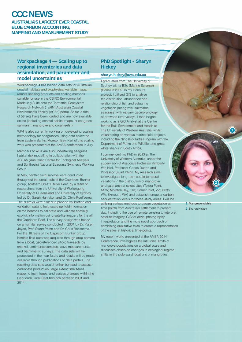
PhD Spotlight - Sharyn [email protected]
I graduated from The University of Sydney with a BSc (Marine Science)(Hons) in 2009. In my Honours project, I utilised GIS to analyse the distribution, abundance and relationship of fish and estuarine vegetation (mangrove, saltmarsh, seagrass) with estuary geomorphology of drowned river valleys. I then began working as a GIS Analyst at the Centre for the Built Environment and Health at The University of Western Australia, whilst volunteering on various marine field projects, including the Ningaloo Turtle Program with the Department of Parks and Wildlife, and great white sharks in South Africa.
I commenced my PhD in 2013 at The University of Western Australia, under the supervision of Associate Professor Kimberly Van Niel, Professor Carlos Duarte and Professor Stuart Phinn. My research aims to investigate long-term spatio-temporal variations in the distribution of mangrove and saltmarsh at select sites (Towra Point, NSW; Moreton Bay, Qld; Corner Inlet, Vic; Perth, WA; Exmouth, WA) and establish temporal carbon sequestration levels for these study areas. I will be utilising various methods to gauge vegetation at time points from Australia’s settlement to present day. Including the use of remote sensing to interpret satellite imagery, GIS for aerial photography interpretation and the more novel approach of combining qualitative texts to create a representation of the sites at historical time-points.
My recent work, presented at the AMSA 2014 Conference, investigates the latitudinal limits of mangrove populations on a global scale and discusses observed changes in ecological regime shifts in the pole-ward locations of mangroves.
1
2
1 Mangrove yabbie
2 Sharyn Hickey
CCC NEWSAUSTRALIA’S LARGEST EVER COASTAL BLUE CARBON ACCOUNTING, MAPPING AND MEASUREMENT STUDY

1
Member Spotlight - Robert [email protected]
My name is Robert Canto and I’m postdoctoral researcher at the University of Queensland.
What is your background?I have a marine science background but the range of research work I have been involved with includes plankton distributions, densities and assemblages; coral reef benthic cover dynamics, mapping aquatic productivity/ocean colour for fisheries. These led to my interest on the applications of remote sensing and GIS towards understanding spatiotemporal abundance dynamics of marine biota in a landscape context.
Previous position and education?I finished my Phd (Geography) in 2012 at the University of Queensland. After which I’ve been involved in the teaching of remote sensing courses and in ongoing research involving mapping/modeling marine biota. As part of the Coastal Carbon WP4, I have a 2 year part time Post-Doctoral position at UQ.
Current ResearchI am working on two projects that both incorporate spatial heterogeneity in understanding change in a landscape context. The first project (part of the Coastal Carbon Cluster WP4) is looking at the methodology of scaling measurements and models (e.g., seagrass structure and processes) done at one scale and correctly translating at different scales. The second project involves an Australia wide spatially explicit modelling of seagrass habitat risks from current and future stressors (temperature change, rainfall, sea level rise).
Who will you be working with most closely in the Cluster?My work is part of WP4, and I am working with Stuart Phinn and Chris Roelfsema on creating scaling framework/methodology which is initially built for seagrass properties but will be modified for mangrove and saltmarsh properties as well. The scaling framework will be used in the CSIRO Environmental Modelling Suite so we are working with Mark Baird to make this possible. It will also be useful to work with cluster members who have extensive field knowledge on the spatiotemporal dynamics of structures and processes of seagrass, mangrove and saltmarshes and get their inputs to improve the scaling framework/methodology.
Why is your research important and how does it fit within the Cluster?Having a spatially explicit/landscape context of a process or feature to be mapped and/or modelled means incorporating spatial heterogeneity. In the past, such effort was not feasible as dynamics and spatial variability of coastal carbon sequestering biotic structures and processes in areas of 10s to 100s of kilometres cannot be representatively covered by field measurements. Thus models of change for a large area were restricted to and based on changes observed at small scales (1 or <1 to 100 metres). At present, remote sensing data enables detecting changes over large areas (10s to 100s of kilometres). Coupling field measurements with remote sensing measurements covering larger extents will therefore lead towards a spatially explicit understanding of change mechanisms, representative of the target landscape extent. This will help in refining modelled coastal carbon estimates by incorporating a spatially explicit component.
Photo credits: Peter Ralph, Peter Macreadie, Bradley Eyre, Sharyn
Hickey and Robert Canto
1 Robert Canto
The CSIRO Flagship Collaboration Fund facilitates involvement of the wider Australian research community in addressing the nation's most significant challenges and opportunities. Flagship Clusters are three-year partnerships between Flagships, universities and other public research agencies.
CCC NEWSAUSTRALIA’S LARGEST EVER COASTAL BLUE CARBON ACCOUNTING, MAPPING AND MEASUREMENT STUDY
CONTACT: Shannon Hawkins
Project Administrator Coastal Carbon Cluster
P 02 9514 1754E [email protected]
W www.csiro.au/Coastal-Carbon-Cluster
F www.facebook.com/CoastalCarbonCluster