Embed Size (px)
Citation preview

7.6
APPENDIX ‘A7’ Braughing Parish Design Statement – Consultation Draft December 2003 Contents 1 Introduction
2 The parish of Braughing
3 Braughing village
4 The hamlets
5 Highways
6 Recreation
7 Business and commerce
8 Architecture and building styles
9 Public buildings
10 Ecology
11 A younger perspective and the future
12 Guidelines – endorsed by EHDC
13 Parishioners’ aspirations – not endorsed by EHDC
14 Appendices
15 Acknowledgements

7.7
1 Introduction
1.1 The parish of Braughing is widespread and diverse in its landscape, its
buildings and its history. At the centre of the parish is the village of Braughing
itself.
1.2 But the village and its surrounding hamlets are more than just the
aggregate of the buildings, streets and meadows. They are the places where
people live and work.
1.3 The Parish Design Statement covers the whole of the parish of
Braughing as well as the village and is intended to enable local people to
have an influence on their environment.
1.4 The Design Statement records many distinctive features which make
up the character of the parish and which contribute to the quality of life.
How was the Statement produced?
1.5 The Design Statement Steering Committee was set up in September
2000 following an initiative from Braughing Parish Council.
1.6 Background information used to develop the Statement came from the
work and archives of various societies and individuals in the parish, from
photographic surveys carried out throughout the parish, from a series of public
meetings and from a questionnaire, which was circulated to all households.
1.7 The Steering Committee and the Drafting Sub-committee developed
this information in order to prepare the Statement, with particular attention to
four main themes: history and heritage; good and sympathetic design;
sustainable and mixed development of the environment; and the aims of the
parish for the future (including the active encouragement of the designation of
a wider Area of Outstanding Natural Beauty embracing Braughing parish and
its surrounding parishes).
7.8
Why have this Design Statement?
1.8 As the Statement reflects the views and wishes of the community as a
whole, it will help to manage change of whatever nature.
1.9 It will ensure that development is consistent with and in sympathy with
its surroundings and that the vibrant rural environment will be enhanced.
1.10 The Design Statement will be supplementary to the Local Development
Plan prepared by East Hertfordshire District Council and therefore will be kept
under periodic review.
Who benefits from the Statement?
1.11 This Statement has been endorsed by East Hertfordshire District
Council, and the Guidelines contained in Chapter 12 adopted as
Supplementary Planning Guidance (SPG). The Guidelines will be taken into
account when planning applications are assessed. In this way the Statement
will support the Local Plan (or its successor) as it affects Braughing and will
assist the work of the Parish Council.
1.12 Guidance and explanations are provided so that developers and their
architects and designers are aware of what the people of Braughing expect in
terms of new and altered buildings, whether residential or commercial in
nature.
How is the Statement set out?
1.13 The Statement has thirteen chapters (including this Introduction), which
give details of the history, environment, buildings and other important features
of the parish.
1.14 Chapter 12 sets out the Guidelines adopted by East Hertfordshire
District Council as Supplementary Planning Guidance.

7.9
1.15 In Chapter 13 are certain elements of the Statement which have not
been adopted as Supplementary Planning Guidance by East Hertfordshire
District Council, but which the parish would wish to be taken into
consideration.
How is the Statement to be used?
1.16 The Statement and the Supplementary Planning Guidelines are to be
used to ensure that any development, regardless of scale, is of a nature,
design, and layout sympathetic to the character of the village and its
surroundings and which will maintain and enhance the parish of Braughing as
a diverse and thriving rural community.
1.17 Developers, planners and residents must consult the Parish Design
Statement, which reflects the views of the community. The Parish Council
must also be consulted with regard to advice concerning facilities to be
provided as a result of new development.

7.10
2 The parish of Braughing
2.1 Located in north-east Hertfordshire, approximately nine miles to the
north of Ware and nine miles to the west of Bishop's Stortford, the parish of
Braughing is predominantly rural in nature. The five farms which make up the
bulk of the land use are mostly arable. On a private level there is also a
significant amount of equestrian use.
2.2 Whilst the village of Braughing forms the main core of the parish's
population, there are several well-defined hamlets in the outlying areas, each
having its own distinct character.
2.3 The River Quin divides the village just before it joins the River Rib,
which in turn runs into the River Lea and onwards to the Thames. Braughing
has two fords through the Quin, frequented by the ducks and geese which
have featured on television. The East Anglian Heights and the River Quin
Valley running parallel north to south create visual interest through the centre
of the parish. A visitor to the area will first encounter the vistas created by
these features when entering the parish on one of the three main vehicular
routes - the B1368, Pelham Road and Stortford Lane. In each case the open
fields provide a picturesque introduction to the village and hamlets. Friars
Road, which crosses the Heights to provide access to Braughing Friars, also
provides a variety of spectacular views over open and unspoilt countryside. It
is this countryside and the village and hamlets, with their wealth of flora and
fauna, which this Statement is intended to protect.
2.4 The population of the parish is estimated at approximately 1,450 with
more than 480 households. There is a broad age range from pre-school to
retired, supporting a considerable number of clubs and organisations within
the parish. Although many residents work outside the parish, a significant
proportion work from home or at businesses within the parish. Business and
employment is to be found in the factory and workshop units near the old
railway station; the butchers, known for miles around for their sausages and
7.11
meat; Jenyns School; the pubs; the Post Office Stores, giving valuable service
to the village since 1930; and the A10 Farm Shop.
2.5 Most of the village lies within a Conservation Area; about half of the
housing is historic. There is, however, a substantial amount of twentieth-
century housing, particularly in Friars Road and Green Lane.
2.6 Braughing is a very lively village, which was awarded the title Village of
the Year, East Hertfordshire, 2002, by the (then) Council for the Protection of
Rural England, in recognition of Braughing’s many cultural and social
activities.

7.12
3 Braughing village
3.1 Braughing is a compact village strategically situated by the rivers Quin and
Rib, among the chalk hills of East Hertfordshire, which are capped here with boulder
clay, flint, sand and gravel. The land in the river valleys was probably marshy in
pre-Roman and Roman times, which is why evidence of early occupation has been
found on the higher ground in the locality.
3.2 There is evidence of the presence of Mesolithic, Neolithic and Bronze Age
hunters and fishers in this area. Settled occupation seems to have begun in the
Iron Age in about the third century BC. Gatesbury (between Braughing and
Puckeridge) and Skeleton Green (north of Puckeridge) have yielded artefacts which
show that trade contacts existed with Italy and Gaul during the later years of the first
century BC. Archaeologists believe that this settlement was one of the most
important Iron Age sites in south-east Britain; it was the furthest navigable point that
could be reached from Europe via the river Thames, and from here goods would
have been distributed all over Britain.
3.3 The Roman settlement at Wickham Hill has never been completely
excavated, but enough can be gleaned from cropmarks and the minor excavations
that have been done to tell us that Braughing was a significant Roman town. The
importance of the town is probably due to it being near the junction of several main
routes - Ermine Street (A10), Stane Street (A120) and others.
3.4 After the Roman occupation came to an end in the early fifth century AD, the
area would have been settled by Anglo-Saxons. The earliest form of the Braughing
name is the Anglo-Saxon Breahingas - meaning the people of Breahha (Breahha
was probably a local leader). There is a theory that Braughing was at the centre of a
huge Anglo-Saxon estate covering the area from the Icknield Way in the north to the
southern border of Standon in the south. Later, Braughing gets a mention in
Domesday Book (1086) as Brachinges. From being a centre of government, both
secular and religious, Saxon Braughing then gave its name to Braughing Hundred,

7.13
the local government administrative area, which eventually evolved into Braughing
Rural District Council.
3.5 It became a self-contained agricultural village supporting numerous trades
and many specialist shops. What is now the B1368 (Green End) was one of the first
turnpike roads in the country providing a main route to the North, via Cambridge.
There was therefore continual traffic passing through the village.
3.6 Traffic of a different kind came to the village in the nineteenth century with
the advent of the Buntingford branch railway. It was while the railway was being
built that a corner of the Roman town was first uncovered, near the station. The line
was a victim of Dr Beeching, and closed in 1964, to everyone's regret, although the
buildings and station environment have been maintained by the present owners and
still exist as a recognisable feature.
3.7 Braughing is now a beautiful village, full of character, which it derives from its
long history and its residents, both past and present, famous and not-so-famous.

7.14
4 The hamlets
4.1 There are four main hamlets within the parish outside the central village, with
some smaller groups of houses and even single houses that mark the location of
larger settlements long since gone. Dassels, Hay Street, Braughing Friars, Upp Hall
and Hamels are the main hamlets, whilst Quinbury, Cockhamsted, Bozen Green
and Rotten Row are now represented by only one or two houses. The hamlets of
Great and Little Hull no longer exist.
4.2 The parish of Braughing once contained ten manors: Braughing (alias
Braughingbury), Cockhamsted, Dassells, Friars, Gatesbury, Hamels with Masters,
Hotofts, Queen(s)bury with Mutfords, Turks and Uphall. Several of these manors
were combined when they came into the ownership of the same landowner.
4.3 Hamels: There has been a building here since the late sixteenth century; its
present appearance dates from the nineteenth century. The house has become
offices, the park (which contains some magnificent trees) has become a golf course,
and outbuildings have been converted into private dwellings. The distinctive feature
of Hamels today is its unity. Some farm outbuildings are at present being converted,
but the historic integrity of the estate has been maintained, and would be damaged
by any further development.
4.4 Great and Little Hull: These hamlets were probably killed by the building of
the Buntingford branch railway, and do not exist today in any form. The only
remaining evidence of their existence is Hull Lane, now a cul-de-sac, which once
led from Braughing to Buntingford via Great Hull.
4.5 Hay Street and Quinbury: The manor of Queen(s)bury is now a farm and
house called Quinbury, to the south-east of Hay Street. Hay Street itself is a thriving
hamlet of 30 houses, some of them of seventeenth-century origin. An important
feature is the open views over the Quin valley. Hay Street is well separated from
Braughing and Dassels, and ribbon development must be discouraged.

7.15
4.6 Dassels: The hamlet of Dassels is a similar size to Hay Street, and also
contains houses dating back to the seventeenth century, as well as more modern
dwellings. The views and independence from the village and other hamlets are
greatly prized.
4.7 Braughing Friars and Cockhamsted: Braughing Friars contains one
sixteenth-century farmhouse (Friars House), and about a dozen twentieth-century
bungalows and houses. The settlement is well screened by hedges and trees, and
has an atmosphere of seclusion. Ribbon development linking the hamlet to the
village would ruin the views and atmosphere. Cockhamsted now consists of one
large house with a moat, and two smaller houses.
4.8 Bozen Green and Rotten Row: Bozen Green once had over 20 households,
but now consists of an early seventeenth-century house, a late seventeenth-century
farmhouse and a barn. Rotten Row farmhouse is a late medieval hall house.
4.9 Gatesbury and Upp Hall: Gatesbury, the site of a watermill until 1906, now
consists of one house. It lies close to the site of an Iron Age settlement. The history
of the manor of Gatesbury was closely connected with that of Upp Hall, which is a
seventeenth-century brick building with an impressive Grade II* listed barn.
4.10 There are various reasons for the survival or non-survival of these hamlets.
The survival of Dassels and Hay Street is no doubt due to their position on a major
coaching route, whilst Braughing Friars is the result of early twentieth-century
plotland development. Agricultural workers probably moved to nearby towns from
some of the other settlements, causing them to shrink or disappear. All of the
hamlets which still exist have their own characteristics, which require careful
handling and thought when developments are considered.

7.16
5 Highways
5.1 Street furniture: at present the street lights, litter bins, salt bins, public road
signs and street name signs have evolved randomly over a period of time, and are
therefore in a mixture of styles. New or replacement street lights should be of a style
consistent with the immediate location, and light pollution should be kept to a
minimum.
5.2 Pavements: tarmac pavements exist within the village and along much of the
B1368. It is unlikely that any new pavements will be provided within the village.
5.3 Rights of Way: the parish is fortunate in having an extensive network of
bridleways and footpaths (unpaved); these are kept clear by trimming twice a year.
The Parish Council and the Parish Paths Partnership work together in maintaining the
rights of way to a very high standard. There is also a long narrow piece of land to the
north of the village called The Bone or Big Bone, a flourishing wildlife area, which is
managed by the Parish Council. Every opportunity will be taken to extend and
improve the footpath system throughout the parish.
5.4 Parking: in much of Braughing village and the hamlet of Hay Street, parking is a
major problem, as car ownership was not a consideration when the houses were built.
It is the intention of this Statement to help to overcome this problem when the
opportunity arises, for example by stipulating that any new development contains
adequate off-street parking.
5.5 Traffic: most of the roads are very narrow; farm machinery and the great
increase in car ownership are putting a strain on the road system as it is at present.
Any attempt to widen the carriageway, edge the roads with kerbs or paint signs and/or
lines on the highways would be seen as an undesirable step towards urbanisation.
5.6 We would like to see restrictions on weight and size of vehicles on many of the
roads and streets in the parish.
7.17
6 Recreation
Buildings and Leisure Activities
6.1 To celebrate the Millennium a yearbook was produced in 2000 and
presented to every household, providing information about all the groups,
organisations and churches that are active in the parish. In this chapter, reference
will be made to some of the village buildings and public spaces that are used for
social and recreational activities.
6.2 The three churches in the village and the respective church halls provide
important venues for parishioners to meet for worship and for a variety of social
activities.
6.3 The Scrabble Club, which has met each month since 1984, uses the Chapel
Hall, located near the Post Office. One local resident remembers part of the Chapel
Hall being used until the 1950s for "Women's Bright Hour", where women could
meet and sing together.
6.4 The earliest parts of the parish church of St Mary the Virgin date from the
thirteenth century and the building is used each week for church services. The
parish church also serves as an excellent venue for performances arranged by
Braughing Music Society. Parishioners have been able to enjoy live music concerts
in the church since 1977, when the society was formed.
6.5 The sixteenth-century Old Boys School and the main Church Hall situated in
the buildings opposite St Mary's are also used as venues for many social and
recreational activities, for example, dancing, aerobics, Horticultural Society shows,
bazaars, private parties, society meetings, and cubs. Until the 1930s the Working
Men’s Club met every weeknight in the Church Hall. The highly popular Music Hall
has been performed in the Church Hall each year by Braughing Drama Group since
1963. Braughing Women's Institute has been meeting in the Church Hall since
1928 and still has an active membership and the Braughing Society, which began in

7.18
the 1970s as a Preservation Society, but now takes a much wider part in the life of
the parish, also meets here.
6.6 The Old Boys School is also used as a meeting place for various
organisations and committee meetings, and has been for over one hundred years.
Such organisations include the Parish Council, which first met there in 1894, the
Golden Age Club, which was founded in 1960 for older residents in the area to meet
and socialise, and more recently, the Aviation Society, established in 1999.
6.7 The Axe and Compasses and the Brown Bear public houses provide
alternative meeting places for the parish and are used by sporting organisations and
other parish groups to take some refreshment after matches and meetings. Crib,
darts, petanque and pool are also on offer to customers.
Allotments
6.8 There are 13 allotments, currently sited next to the playing field and
children's playground. Parish Councils have power to provide allotments for
personal cultivation and are required to do so if six or more parishioners request
allotment space. Parish Council minutes from 1908 indicate that originally the
allotments were to be available only for labourers' use, but in 1919 the Parish
Council also encouraged letting for use by discharged sailors and soldiers.
Numerous references to allotments are found in the Parish Council minutes
between 1908 and 1937, revealing varying levels of demand, together with the
discussion of appropriate sites and proposed rents during this period. Allotments
have previously been sited in Down Field (Braughingbury Farm) and other previous
locations are yet to be identified. These visually important open spaces have been
evident in the parish for over a century.
Playing Field
6.9 There has been a cricket team in Braughing since 1911. The original site for
the pitch was in Hay Street; then they moved to Vicarage Meadow near the ford in
Gravelly Lane, but in 1973 the home ground moved to the current site on the

7.19
playing field. Braughing Rovers football team now also use the playing field, having
previously played on a pitch at the top of Hull Lane since the 1930s.
6.10 At one time children were able to play on the recreation ground at the top of
Green Lane, but this has been developed as accommodation for the senior citizens
of the parish in recent years (Longmans). The decision to find a suitable piece of
land for a permanent playing field for the village was taken at a public meeting in
1964. After many discussions, grant applications, false hopes, and fund-raising
events, the Braughing Playing Field Association Trust took ownership of the present
site in 1969 and the pavilion was opened in 1973. The playing field and pavilion
(now the Community Hall) still provide an essential recreational facility for all
parishioners and are used by, among others, the cricket club, the football teams, the
tennis club, Guides, the carpet bowls clubs, and Pumpkins pre-school.

7.20
7 Business and commerce
7.1 Rural villages like Braughing have developed either as farming communities
or as a result of their location on important road or track systems. From the initial
nucleus, populations increased and businesses developed to satisfy local demands
for goods and services.
7.2 While transport systems were limited, the population confined their
purchasing power to the local shops and businesses. However, as transport
facilities (especially the motor car) allowed easier movement and access to larger
commercial centres, the need for local shops decreased and many of them closed
down.
7.3 As farming became more mechanised and fewer people were employed on
the land, many rural villages have become “dormitories” where a significant
proportion of the population leave every morning to work elsewhere, and Braughing
is no exception. This in turn has resulted in a dangerous reduction in the number of
businesses remaining in rural areas. In Braughing, a departure from this trend is
the relative success of the light industrial estate by the old station. The
mechanisation of farming has also resulted in a changed landscape, with the loss of
hedgerows and wildlife.
7.4 We consider it important that Braughing should retain retail and other business
premises. New businesses which are consistent with and sympathetic to a rural
environment, or which entail people working from home, will be encouraged.
7.5 However, it is an economic fact that once a change of use is granted away
from retail or business use, such use would effectively be lost for ever. We would,
therefore, strongly resist the loss of any remaining business or commercial uses,
unless there is overwhelming evidence to confirm that the premises are incapable of
being economically viable.

7.21
8 Architecture and building styles 8.1 Braughing is fortunate in that the developments of the last fifty years have
not destroyed a character that has evolved over centuries. Traditional designs,
techniques and materials still predominate, and the original open plan of the
settlement has not been lost.
8.2 However, there are in the village some notable examples of what might be
termed bad practice. The object of the Statement is to prevent similar mistakes in
the future, and thus preserve what is unique about our village, while still making
provision for change.
8.3 The parish contains examples of most local styles of vernacular domestic
architecture in a continuous sequence spanning the last 600 years, from late
mediaeval hall houses such as The Gate House and The Gables to 1950s
bungalows and social housing of the 1970s and 1980s. Braughing is proud to be
one of the first parishes to have publicly funded housing – a row of four cottages
was erected in 1912 at Green Hill Close; they are still occupied today. The overall
effect is of consonance rather than uniformity – although there are clear and
undeniable exceptions to this. There is little in the way of grand or imposing
architecture: most of the older buildings bespeak modest prosperity rather than
great wealth, prizing practical comfort above tasteless ostentation. The character
and appearance we wish to preserve and enhance is perhaps best demonstrated by
The Square and Church End, close-packed houses of many different periods, with
no uniform width of frontage and no common roofline, constructed in different styles
of varied materials using a range of techniques. This variation makes explicit the
fact that, until the advent of the first social housing, development in the village was
small-scale and piecemeal. Large blocks of development are, historically and
aesthetically speaking, alien to Braughing.
8.4 One modern development (Uplands) was constructed with the best of
intentions, to provide additional low-cost housing, but falls short of acceptability in its
execution. Not only is the style very much “of its time”, but also no concession is

7.22
made to its surroundings. What is suitable for an urban or suburban area works far
less well in a rural setting. Another (private) development (in Gravelly Lane), again
consisting of several houses, seems to be trying to shut itself off from the rest of the
village – anomalous in a community largely constructed by people who were not
afraid of their neighbours.
8.5 The development on the former garage site adjacent to the Post Office is
generally commended as an example of well-designed and sympathetic
development. Its style is in keeping with its surroundings, so that it is not at once
obvious as a modern structure. It includes adequate off-street parking which is
unobtrusively situated. The dwellings are at the affordable end of the market, they
are modest in scale and appearance, and they form a valuable addition to the
housing stock of the village. The limited amount of development which would be
permitted in the future should accord with these basic principles.
8.6 What decorative techniques are appropriate to the parish? The herringbone
brick infill of the Old Boys School and the brick guttae (drop-shaped ornaments) of
the Old Manse are local traditional ornamental styles which can still be achieved
today with readily-available materials in a way that is not possible with, for instance,
timber framing. Modern machine-cut timber cannot reproduce the effect of hand-
sawn and often reused timber. Pargetting is not traditionally a common technique in
the parish, and those examples which are authentic tend more to the simple and
restrained – such as the decoration of The Rose and Crown in Church End.
Perfunctory gestures towards a “traditional” style are as inappropriate to an East
Hertfordshire village as are the obviously modern materials of which the houses are
made.
8.7 It seems natural to conclude this very brief survey of our village with St
Mary’s – our church. It lies at the geographical and social heart of Braughing, and
the history of our village is written in its walls. Like the village, it is an architectural
palimpsest, centuries in the making, with re-used Roman brick in the fourteenth-
century tower, a thirteenth-century chancel, the early seventeenth-century Brograve
Chapel and nineteenth-century restoration work in flint. Yet there is between all

7.23
these disparate elements a clear harmony. Each generation as it has made its own
contribution has had regard for the intentions and achievements of those who went
before, and this would seem to be the message for our own time, that the best
provision we in the present can make for the future is to complement and enhance
what the past has left us, not wantonly to destroy it.

7.24
9 Public buildings
9.1 There are several public buildings of note in Braughing. The parish church of
St Mary the Virgin (described in Chapter 8) occupies a central position in the village.
There is a nineteenth-century Methodist church opposite Jenyns School, and a
Congregational chapel in Fleece Lane. This chapel (a converted barn, probably
originally sixteenth century) was re-erected in Braughing in 1762, having been
brought from Datchworth, where John Bunyan is said to have preached in it.
9.2 The brick-built Church Hall was opened in 1904, and next to it are the
sixteenth-century Old Boys School and caretaker's cottage, which now form part of
the Church Hall complex. Also in the village are the Chapel Hall in Green End and
the Community Hall, which is sited in the playing field off Green Lane.
9.3 The handsome war memorial is maintained by the Royal British Legion and
the Parish Council.
9.4 There are three public houses in the village, the Axe and Compasses, the
Brown Bear and the Golden Fleece (currently closed and seeking change of use).
All of these pubs are old buildings; the Brown Bear is thought by some to be the
oldest building in Braughing apart from the parish church. Many houses in
Braughing used to be inns, and this is reflected in their names such as the Rose
and Crown, the Adam and Eve, and the Black Bull, all of which were on one or other
of the old roads to the North via Cambridge.
9.5 Jenyns School was built in the second half of the nineteenth century. It is still
a thriving school, and the buildings are soon to be replaced with a modern building
which will have a capacity of 120 pupils. The existing Victorian buildings will be
converted into residential accommodation.

7.25
10 Ecology 10.1 Braughing is rich in wildlife, ranging from large mammals, such as fallow
deer, to insects attracted by the wild plants that are to be found in the woodlands
and hedgerows.
10.2 A wide variety of habitats is to be found in the parish. There are patches of
woodland containing oak, ash, maple, hornbeam, hazel, and alder; marshy areas;
areas of unspoilt grassland; hedgerows and ditches; the old railway line; the
churchyard; and of course domestic gardens. A recent survey provides evidence to
suggest that many of the hedgerows in the parish are of ancient origin, all of which
must be protected.
10.3 The woodlands shelter many mammals including fallow and muntjac deer,
badgers and foxes. Many species of birds have been identified, but in recent years
numbers have been falling due to intensive agriculture and the use of pesticides,
practices which also affect the number of butterflies, moths and other insects.
However, the number of hornets has been rising! At least six different types of bat
are known to live in the parish. One walk in the parish yielded a list of over 200
different types of plant. The marshy areas have a thriving population of frogs, toads
and newts, and there is a toad crossing point on the B1368. The conversion of
barns is seriously reducing the available habitat for the owl and bat populations, and
there is concern for their future presence in the parish.
10.4 The residents value highly the diversity of wildlife to be seen and enjoyed in
the parish, and feel that it is vitally important that this biodiversity is not harmed.

7.26
11 A younger perspective and the future
Jenyns School
11.1 As part of the process of consultation with the local community, children from
Jenyns First School in Braughing have been invited to share their ideas about the
benefits of living in the parish and their ideas for the future. Discussions with
children in Class 4 (8 - 9-year-olds) on the best things about living in the parish
revealed their appreciation for the surroundings and the opportunities provided
through such a rural community.
11.2 They commented on the amount of space they had to play in, large gardens,
not being cramped, being able to ride their bikes round to their friends, and places
to explore such as Big Bone. They also appreciated other attributes including the
quietness, the birds singing, feeling safe, walking through the bluebell woods, no
rubbish, being able to ride their ponies, and going on their own to knock for friends
or to the Post Office Shop.
11.3 The number and variety of clubs and activities attended by these children
was surprising and included piano, tennis, football, dancing, Sunday School, choir,
cricket, cubs, riding, drama and French – all within the parish.
11.4 The children also had views on aspects of the parish that they would like to
change or see developed. Several children would love to have skate board ramps,
and a swimming pool was another favourite request. One boy suggested changing
“some of the roads, some of the very modern houses and having a bit that comes
out in the road like this \ II _II_II/ to slow cars down”.
Older Children
11.5 Braughing is blessed with a vibrant, articulate and generally thoughtful
younger generation (ie those young people up to mid-teens who have mostly been
to Jenyns School and then on to secondary education elsewhere in the county).

7.27
11.6 These young people represent the future of the parish and it is, of course, the
purpose of this Statement and the guidelines set out in Chapter 12 to help maintain
and enhance the parish as a diverse and thriving rural community for their ultimate
benefit.
11.7 What is it that the younger generation like about their parish? Not
surprisingly, there are several different aspects of Braughing which are of significant
importance to them. But looked at collectively, there is a constancy to the aspects
which clearly represents what Braughing is like today.
11.8 They say that the surrounding landscape is beautiful; the village and the rest
of the parish are peaceful and green and have an atmosphere of safe seclusion.
Concrete is certainly not in evidence and the houses (at least the older-established
ones) are pretty and different in styles. Braughing is conveniently situated with easy
access to local towns and countryside and, of course, the famous Braughing
sausages seem to form part of most of the young people’s diet!
11.9 Uniformity of building design or style is something which, in their opinion,
should be avoided and it has to be said that newer development in the village is not
generally liked by them. Perhaps somewhat surprisingly, there is almost unanimous
antipathy towards further development in the parish notwithstanding the fact that
such development could bring more young people into the community. However, if
there were to be new houses built, the preference would be for more “affordable”
houses rather than those which are perceived as being “out of reach” of those who
would wish to remain living in the village.
11.10 Whilst there is no doubt that young people derive a lot of their opinions from
their parents, there is a mature attitude to future development. For example, they
would like to see more retail/commercial activity in the parish rather than less
(“wouldn’t it be nice to have a bakery?”), a view probably echoed by some of their
elders!

7.28
11.11 Recreation comes pretty high on their list of priorities and they would like to
see a vigorous youth club re-established which they would be keen to help manage.
A place specifically set aside for bike and skate ramps is very much in demand,
something which the Parish Council is addressing. What is perhaps more
interesting is that the young people wish to see greater facilities for riding bicycles
off road, for example, by the river banks, which they want to see enhanced and
made more readily accessible to people in the parish.
11.12 In terms of appearance of the village, they are concerned about litter and
fouling by dogs and horses, and want to see more bins to cure these problems.
They are not too happy about properties hiding behind large gates and they are not
at all in favour of a bus shelter as it would be out of place and obtrusive.
11.13 One last point, which perhaps demonstrates the gap between generations, is
that they would like to see more street lighting, particularly in those areas of the
village which are away from the main streets, such as Fleece Lane. Although they
consider the village to be generally safe, there are some areas which they find
“scary” and this aspect of public safety must be borne in mind.
A brief overview and the future
11.14 As we said in the Introduction, the parish of Braughing is a place where
the young and those past the bloom of youth play, learn and enjoy their leisure.
11.15 Even the briefest of visits to Braughing will reveal what a beautiful parish it
is, and so it is hardly surprising that the values of beauty, diversity, safety,
seclusion, our heritage and the aspirations for the future are shared by young and
old alike.
11.16 However, we must not be oblivious to the dark clouds on the horizon
which, over time, will come ever closer and cast their sinister shadow not only on
the parish of Braughing but also on neighbouring parishes which, too, are situated
in areas of outstanding beauty and historical and archaeological interest.

7.29
11.17 It is, therefore, incumbent upon ourselves and successive generations to
devote our energies to protecting these values which history has given as its legacy
and also to work closely with our neighbours to ensure that there is an integrated
and collegiate approach to the preservation of our common environment.
11.18 With this in mind we in the parish of Braughing will make every effort to
work in harmony with other parishes, all tiers of government and organisations such
as the Local Heritage Initiative, Parishes for Rural Environment Protection,
Hertfordshire Association of Local Councils, North West Essex and East Herts
Preservation Association and the Campaign for the Protection of Rural England.
11.19 Through this co-operation and through positive involvement in Community
Planning for rural parishes, it is our expectation that we would wish to support the
pursuance of Landscape Character Assessment and the enhancement and
extension of areas designated as Areas of Archaeological Significance and Sites of
Special Scientific Interest, and, over the longer term, actively pursue the designation
of this area and its surroundings as an Area of Outstanding Natural Beauty.
11.20 It will have become clear from this Statement that some growth and
development within the parish and the maintenance and, indeed, the expansion of
suitable commercial/retail enterprises will not be unwelcome. But any such
development must , of course, not only comply with the Guidelines set out in
Chapter 12, but also be enhancing for the community as a whole within the spirit in
which this Statement is presented.

7.30
12 Guidelines – endorsed as SPG by EHDC
Group 1 – Development
1.01 The settlement patterns of the village and hamlets are the key to the
distinctive nature of the various parts of the parish. New developments, as well as
alterations and extensions to existing buildings, must harmonise with the overall
appearance of their surroundings and respect existing patterns and densities of land
use.
1.02 No new development will be supported outside the village boundary, as
defined in the East Hertfordshire Local Plan Second Review, Draft Deposit Version
(December 2000), other than such development as is agreed between the Parish
Council and East Hertfordshire District Council as being appropriate.
1.03 Any new development should help to enhance the social mix and shall have
due regard to the requirements of the local community, the balance and type of
properties already existing and the need to ensure that adequate affordable
accommodation is provided.
1.04 Garages and outbuildings must not be disproportionate to the size of the
property they are intended to serve, and they must conform to all other principles
affecting new developments. Accesses must provide adequate sightlines without
being out of scale with the street on to which they open and should preferably be
constructed of locally appropriate materials. Concrete block paving, bare concrete,
patterned and coloured concrete, and large expanses of tarmac, whether coloured
or plain, are all to be avoided. York stone, hoggin, gravel, fired brick paviours and
granite setts are all acceptable materials for drives.
1.05 Proposals for change of use from commercial to another use will be
discouraged, other than in exceptional circumstances.

7.31
1.06 The conversion of traditionally-built barns and other outbuildings shall be
carried out with a view to retaining the original character of the building and without
damaging their value to wildlife or conservation concerns (eg bats and owls).
1.07 Existing focal points shall be utilised in any development and new focal
points, where they preserve or enhance the character of the locality, will be
encouraged.
Group 2 – Design
2.01 The front elevation of a building is its most public face. Great care must be
taken, therefore, to ensure that the frontage of a new or altered building does not
appear out of proportion or character with surrounding buildings.
2.02 Nothing other than traditional materials and colour schemes would be
appropriate within the Conservation Area, or in respect of listed buildings, as
synthetic materials lack character, and will be discouraged.
2.03 In any new development the style and appearance shall be consistent with
the properties in the immediate locality, with a sufficient variety of styles. However,
this does not mean that houses of a good modern design would not be acceptable
in some cases.
2.04 It is essential that any development must be in proportion to surrounding
buildings, especially in terms of front elevation, preserving traditional ratios of doors
and windows to total area of frontage.
2.05 Density must be appropriate to the location and nature of the properties to be
built, with an adequate spatial ambience suitable to the existing rural environment.
Any large group of houses to be developed shall be sub-divided to resemble the
smaller random groupings produced by the evolution of the village.

7.32
2.06 Application for development and/or change of use of land or buildings will not
be recommended for consent if there has been conscious dereliction or neglect.
2.07 New commercial property, or proposals for conversion of existing property for
commercial purposes, shall be designed to harmonise with the predominantly
residential and farming rural character of the parish and must be to high
architectural standards.
2.08 Flat roof construction is to be avoided. The use of synthetic slate and
concrete tiles will be discouraged where the character and appearance of the
locality would be neither preserved nor enhanced.
2.09 The use of red brick and flint is to be encouraged where consistent with the
surrounding properties and environment. Rendering and simple pargetting in local
traditional patterns is sometimes used on listed buildings, and would also be
appropriate on adjacent new structures.
2.10 External timber cladding to some listed buildings has in the past been
overlaid with rendered surfacing where original timbers have become damaged or
rotted. Future alteration or renovation works should encourage reinstatement of the
original timber clad features where appropriate.
2.11 Concrete cladding and prefabricated sectional walling are unacceptable as
structural facing materials and fake exposed timber framing is to be avoided.
2.12 Brickwork, including replacement brickwork, should blend in with surrounding
walling, in both colour and texture. The Old Boys School is a good example of a
local decorative brickwork style. The Old Manse, with its brick guttae (drop-shaped
ornaments) under the eaves, demonstrates another locally appropriate decorative
technique.

7.33
Group 3 – Environment
3.01 We will encourage the improvement of the environment on farmland and
other open areas of land through the preparation of Land Management Schemes
which can be readily monitored by the Local Planning Authority (and which may be
eligible for subsidy and grants to assist in the process).
3.02 Buildings should as far as possible be constructed for maximum energy
efficiency, using low-impact technologies and reclaimed, recyclable or
biodegradable materials wherever possible.
3.03 The preservation and enhancement of footpaths and bridleways shall be of
significant importance, together with the extension of the present footpath system.
Where appropriate any proposed development shall provide a contribution towards
an improved footpath system within the village and in the parish generally. This
could be negotiated as “planning gain”, directly related to the proposed
development.
3.04 The open character of the village and parish shall be preserved. Significant
spaces or gaps (ie the “spaces in between”) important to the form and/or setting of
the village and parish shall be maintained.
3.05 Ribbon development must not be allowed, and the distinct boundaries of
each hamlet and settlement must be preserved.
3.06 Native hedgerows and woodlands and mature trees must be preserved. The
planting and management of hedgerows will be encouraged. Ancient hedgerows
which have been identified shall be preserved at all costs. Proposals for the
preservation of important areas of flora and fauna shall be an important part of
development or alteration proposals where appropriate. No areas of archaeological
or ecological significance should be damaged.

7.34
3.07 Boundaries shall be marked, preferably with hedging, particularly in front
gardens and on road frontages. The use of close-paled or preformed timber fence
panels is to be avoided on road frontages.
3.08 Boundary enclosures shall not exceed 2m in height, and walling shall be plain,
and built of brick or flint. Concrete or concrete panels will not be accepted,
particularly in the Conservation Area. Picket fences and post and rail are
acceptable. They shall not be painted or stained in bright colours. Hedges are
preferable to fences or walls wherever possible, and they should be of native
species. Hornbeam, beech, field maple, Viburnum lantana, Viburnum opulus,
English privet and hazel are interesting and ecologically sound additions to the
more common hawthorn or blackthorn. For screening, holly and yew make useful
native evergreen hedges.
3.09 Any development or change of use that may encourage additional heavy
goods vehicle movements which would have significant adverse effect on the local
environment, either to the rural character of the road or to residential properties
along it, will not be permitted.
3.10 Advertising for the business at any particular premises, or business
identification, shall be discreet, visible only within close proximity of the building
concerned, and below eaves level. Brass plaques of no more than 450mm x
300mm would be acceptable. Signs shall preferably be non-illuminated. Where
illumination is necessary it shall be discreet.
3.11 Applications for alteration and development should incorporate a photograph
of the street scene and elevation/artist’s impression to show the proposal in the
context of the area, unless manifestly inappropriate.
3.12 Whilst solar panels are to be encouraged from an ecological point of view,
they should be placed in an unobtrusive location.

7.35
3.13 We support the Environment Agency’s flood plain plan and the exclusion of
any development within the recognised flood plain areas.

7.36
13 Parishioner’s aspirations – not endorsed as SPG by EHDC
i We would wish to discourage development on any land designated on the
Development Plan as an SSSI (Site of Special Scientific Interest), or AAS (Area of
Archaeological Significance).
ii Where permission is granted for development, we would wish to negotiate a
“planning gain” for the benefit of the parish, either as a monetary contribution to
parish funds or as a project to be discussed and agreed with the Parish Council.
iii All new houses must have at least two off-street parking spaces.
iv Where existing houses do not have off-street parking spaces, future
opportunities will be taken to negotiate the release of land for the purpose of
providing either parking spaces or access to rear gardens where parking spaces
can be made available. Where appropriate this may be negotiated as “planning
gain” where planning permission is being sought by the owner of land in close
proximity to properties in need of off-street parking spaces.
v The roads within the Conservation Area should be provided with Victorian-
type low-wattage street lighting, whilst other areas may be provided with a more
modern lighting style. Additional street lighting will be kept to a minimum consistent
with safety. All street lighting should be of a type that minimises light pollution.
vi Oil and gas storage tanks should be placed in unobtrusive locations and
suitably screened, preferably with suitable soft planting.
vii Satellite dishes placed on listed buildings and on buildings in the
Conservation Area shall be located discreetly and unobtrusively.
viii Works carried out by or on behalf of public service utilities should be notified
to the Parish Council suitably in advance with the intention of ensuring:

7.37
a) that the work of several authorities affecting the same area can be
properly co-ordinated, and
b) that damage is limited and that proper arrangements are in hand for
satisfactory reinstatement. These arrangements should include the
lodging of a bond with the local council against a failure to reinstate
the highway. This should include the siting of highway signs and
street furniture.
ix Traffic calming measures are to be given serious consideration with a view to
achieving a reduction of traffic speed on the road system
x Excessively bright external lights will be discouraged.
xi Through the Parish Council we will continue to pursue the ultimate
designation of this and adjacent parishes as an Area of Outstanding Natural Beauty.

7.38
14 Appendices Appendix 1
BRAUGHING PARISH DESIGN STATEMENT
QUESTIONNAIRE AND ANALYSIS OF REPLIES
Survey data for Hay Street, Dassels, Hamels, Green End, Braughing Friars, Station Road, The Street, Gravelly Lane/Gravelly Dell, Malting Lane/Church End, Friars Road, Green Lane, Northfield, Southfield, Uplands and Longmans
Grand totals - All districts
159
1. If we have to have some new houses in the parish, what types of houses would you like to see? Large houses with garages 27 (17%)Starter homes 49 (31%)Terraced houses 25 (16%)Small houses with parking spaces 72 (45%)Bungalows 25 (16%)A combination 73 (46%)2. Do you think any new houses should be built as infill (i.e. two or three slotted in amongst existing houses) or on a separate new site (Greenfield or brownfield)? Infill 86 (54%)Greenfield 14 (9%)Brownfield 108 (68%)3. Would you like to see more houses to rent? Yes 72 (45%)No 64 (40%)4. At present, houses in the parish are built using many different materials. Which building materials would you prefer for new houses? New brick 38 (24%)Rendered brick 51 (32%)Other Old brick 103 (65%)Half timbered 66 (41%)Weather boarding 48 (30%)5. What sort of roofing material would you prefer? Pantiles 63 (40%)Clay tiles 87 (55%)Thatch 59 (37%)Slates 76 (48%)Concrete tiles 11 (7%)Other 6. Do you think the house plots should be enclosed or left open plan? Enclosed 120 (75%)

7.39
Open borders 42 (26%)7. If you said yes to enclosed in question 6, how would you like to see
them enclosed? Walls 31 (19%)Hedges 101 (63%)Fences 48 (30%)Other 8. Do you think the Design Statement should take environmental considerations into account when making recommendations about buildings? Yes 144 (91%)No 7 (4%)10. Would you like to see more work units in the parish, providing employment opportunities for local people? Yes 100 (63%)No 47 (30%)11. Do you think it important to keep the open spaces which exist now in the parish? Yes 152 (96%)No 2 (1%)12. Do you think that car parking is a problem in the parish? Yes 107 (67%)No 43 (27%)Would the provision of off-street parking help? Yes 102 (64%)No 32 (20%)13. Do you think it is important to retain amenities like the allotments and the playing field? Allotments Yes 132 (83%)No 16 (10%)Playing fields Yes 156 (98%)No Other 14. Do you think that premises which are now used as shops and pubs, or are used for industrial purposes, should be allowed to change to residential use? Yes 35 (22%)No 115 (72%)15. Do you think that residential properties should be allowed to change to retail or industrial use? Yes 78 (49%)No 75 (47%)16. Do you think the Design Statement should make recommendations about public transport? Yes 132 (83%)No 19 (12%)
7.40
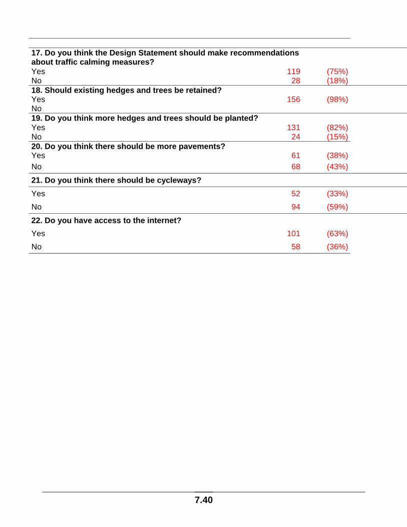
17. Do you think the Design Statement should make recommendations about traffic calming measures? Yes 119 (75%)No 28 (18%)18. Should existing hedges and trees be retained? Yes 156 (98%)No 19. Do you think more hedges and trees should be planted? Yes 131 (82%)No 24 (15%)20. Do you think there should be more pavements? Yes 61 (38%)No 68 (43%)21. Do you think there should be cycleways? Yes 52 (33%)No 94 (59%)22. Do you have access to the internet? Yes 101 (63%)No 58 (36%)

7.41
Appendix 2 LIST OF BUILDINGS OF SPECIAL ARCHITECTURAL OR
HISTORIC INTEREST
Bozen Green Cat and Fiddle, Bozen Green Grade II Bozen Green Farm House Grade II Bozen Green Farm Barn Grade II Braughing Friars Friars House Grade II Braughing Village Braughing Church Grade I Braughing Churchyard, Wren Monument Grade II Braughing Churchyard, Tomb Chest Grade II Braughing Churchyard, Paltock Monument Grade II
3 Church End, Causeway House Grade II Outbuilding at 3 Church End, Causeway House Grade II 6 Church End, Old Boys School Grade II 8 Church End, Church Cottage Grade II 5 Church End, Causeway Cottage Grade II 5 Church End, Causeway Cottage Barn Grade II 10 & 11 Church End, Churchgate House Grade II 13 Church End, Old Rose & Crown Grade II* 14 Church End, The Hoppit Grade II 15 Church End Grade II 17 Church End Grade II 18, 19, 20, & 21 Church End Grade II Fleece Lane Footbridge Grade II Braughing Chapel, Fleece Lane Grade II Ford Street Farm House Grade II Ford Street Farm Granary Grade II 9 Ford Street, Quin Cottage Grade II 10 Ford Street, Green Hill Cottage Grade II 12 Ford Street Grade II 38 Friars Road, Dudley Cottage Grade II 39 Friars Road, The Thatches Grade II Ford Bridge (over River Rib) Grade II 1 Green End, Hill House Grade II 3 Green End Grade II 4 Green End, Larks Hill Grade II 5 Green End, Chestnuts Grade II Park Cottage, Green End Grade II 6 Green End, Post Office Grade II 11 and 13 Green End Grade II 14 Green End, The Manse Grade II 14 Green End, (Cottage at Rear) Grade II 15 Green End, (and Raised Pavement in Front) Grade II 16, 18 and 18A Green End Grade II

7.42
17 Green End Grade II Old Barn and Outhouse at 19 Green End Grade II 19 Green End, The Gables Grade II 20 Green End, The Golden Fleece Grade II 22 Green End, Fleece House Grade II 24 & 26 Green End, Bird In Hand Grade II 28 Green End, Moonrakers Grade II 30 Green End, Ships Timbers Grade II 36, 38, 40, 42 and 44 Green End Grade II Mile Stone to North of Griggs Bridge Grade II Braughing Bury Grade II* 4 Green Lane Grade II 8 Green Lane, Coltsfoot Cottage and Crowsfoot Cottage Grade II Ivy Cottage, Malting Lane Grade II 5-8 Malting Cottages, Malting Lane Grade II Village Pump, The Square Grade II 1 The Square, The Old Bakehouse Grade II 2 The Square, Pump House Grade II 3 The Square, Red Stack Grade II 4 The Square Grade II
5 The Square, Benedict Grade II K6 Telephone Kiosk, The Square Grade II 3 The Street, Robbers Cottage Grade II 7 The Street, Thyme Cottage Grade II 8, 10 and 12 The Street Grade II 11 The Street Grade II 14 The Street, The Brown Bear Grade II 14 The Street, Outbuildings Grade II 15 The Street, The Old Forge Grade II 16 The Street Grade II 22 The Street, Gatehouse Grade II Pentlows Farm, Farm House Grade II Pentlows Farm, Outbuilding Grade II 24 The Street, The Habit Grade II 28 The Street, The Axe and Compasses Grade II The Old Vicarage Grade II The Old Vicarage, Outbuilding Grade II Upp Hall Grade II* Upp Hall Barn Grade II* Upp Hall Granary Grade II Upp Hall, Gate piers Grade II Warren Farm Farmhouse Grade II Gatesbury Grade II Gatesbury Mill Bridge and Sluice Grade II
Cockhamsted Cockhamsted Grade II

7.43
Dassels Turks Cottage Grade II Edwinstree Grade II 1 Totts Cottage Grade II 3/5 Totts Cottage Grade II Dassels House Grade II Bethel Cottage Grade II Dassels Bury Grade II Dassels Bury, Barn and Stable Grade II The Cottage Grade II Hamels and Surrounding Area Hamels Mead Grade II Hamels Park Lodge (1) Grade II Hamels Park Lodge (2) Grade II Mile Stone in Hamels Park Grade II Hamels Park Farm House Grade II East Barn at Hamels Park Farm Grade II Granary at Hamels Park Farm Grade II South Barn at Hamels Park Farm Grade II Gardeners Cottage Grade II Wall, South Gate and Sundial in Hamels Park Garden Grade II Hamels Mansion Grade II 1-5 Hamels Mansions Grade II Hay Street Marshalls Cottage Grade II Monkhams Cottage Grade II The Cottage Grade II Adam and Eve Grade II Rose Cottage Grade II Rotten Row Rotten Row Farm House Grade II

7.44
15 Acknowledgements Grants: the Countryside Agency (Local Heritage Initiative), Nationwide
Building Society, East Hertfordshire District Council, Braughing Parish
Council, The Boots Company plc
© Braughing Parish Design Statement Steering Committee/Braughing Parish Council 2004 Members of the Steering Committee: David Williamson (Chairman), Jo Cain, Mary and Mike Cockburn, Lotte and John Farnham, Chris Gates, Val High, Michael Howard, Sue Landon, Tricia Lilley, Liz Lysaght-Mason, David Matthews, Doug Parfett, Roger Partridge, Andrew Peat, Anne Rowe, Don Ruggiero, Sandy Varley, Graham Ward. The coin used on the front cover is a bronze dupondius of the emperor Antoninus Pius (AD 138 – 161), and formed part of a cremation burial, with other grave goods such as pottery and glassware, in Skeleton Green, near Braughing. The burial was likely to have taken place some time between the dates listed above. Image used courtesy of Hertford Museum. Maps printed courtesy of Ordnance Survey under Licence no issued to East Hertfordshire District Council ?? Sketches by Sue Landon and Sheila Gates Photographs courtesy of Chris and Sheila Gates, David Smith, The Braughing Society Photograph Collection and Vic Flintham Layout and Design: Sheila Gates Editor: Val High