Embed Size (px)
Citation preview

Biological Assessment and Biological Evaluation Potters Canyon Veratrum Project
i
Contents
Introduction ..................................................................................................................................... 1
Description of the Proposal ............................................................................................................. 1
Summary of the Proposed Action ................................................................................................1
Purpose and Need ........................................................................................................................3
Project Area Description/Affected Environment .........................................................................3
Rocky Mountain-Vancouverian Subalpine & High Montane Mesic Grass &
Forb Meadow (USNVC 2016) ................................................................................................ 4
Evaluated Species Information ....................................................................................................... 5
Threatened, Endangered, Proposed, and Candidate Species .......................................................5
Sensitive Plant, Terrestrial Wildlife, and Aquatic Species ............................................................. 5
Pre-Field Review and Survey Information ..................................................................................5
Species Descriptions and Analysis of Effects ............................................................................... 12
Threatened, Endangered, Proposed, and Candidate Species ........................................................ 12
Sensitive Plant, Terrestrial Wildlife, and Aquatic Species ........................................................... 13
Northern Goshawk .....................................................................................................................13
Direct and Indirect Impacts ................................................................................................... 13
Cumulative Effects................................................................................................................ 14
Determination ....................................................................................................................... 15
Peregrine Falcon ........................................................................................................................15
Direct and Indirect Impacts ................................................................................................... 15
Cumulative Effects................................................................................................................ 15
Determination ....................................................................................................................... 16
Spotted Bat .................................................................................................................................16
Direct and Indirect Effects .................................................................................................... 17
Cumulative Effects................................................................................................................ 17
Determination ....................................................................................................................... 17
Determination of Effects ............................................................................................................... 18

Biological Assessment and Biological Evaluation Potters Canyon Veratrum Project
ii
Threatened, endangered, proposed, and candidate species ........................................................19
Aquatic Wildlife Species ...................................................................................................... 19
Terrestrial Wildlife Species .................................................................................................. 19
Plant Species ......................................................................................................................... 19
Sensitive Terrestrial Wildlife, Plant, and Aquatic Species ........................................................19
Terrestrial Wildlife Species .................................................................................................. 19
Plant Species ......................................................................................................................... 20
Forest Plan Consistency, Discussion of Extraordinary Circumstances,
and Consideration of Best Available Science ............................................................................... 20
Forest Plan Consistency .............................................................................................................20
Consideration of Best Available Science ...................................................................................20
Irreversible and Irretrievable Commitments ..............................................................................21
Literature Cited ............................................................................................................................. 22
Appendix 1: Figures
Appendix 2: Identified Past, Present, and Reasonably Foreseeable Actions
within the Cumulative Effects Analysis Area
Tables
Table 1. Federally listed and candidate animal and plant species that could occur
within the Potters project area in Sanpete County, Utah, and their consideration
in this biological assessment and biological evaluation (BA/BE). ............................... 6
Table 2. Sensitive animal and plant species that could occur within the project area
in Sanpete County, Utah, and their consideration within this biological assessment
and biological evaluation (BA/BE). .............................................................................. 9
Table 3. Summary of determination of effects. ........................................................................ 18
Figures
Figure 1. Percent of monitored northern goshawk nests that were occupied on the Manti
Division of the Manti-La Sal National Forest from 1995 through 2007. ................... 14

Biological Assessment and Biological Evaluation Potters Canyon Veratrum Project
1
Introduction The purpose of this Biological Assessment/Biological Evaluation (BA/BE) is to review the
potential effects of the Potters Canyon Veratrum californicum (known as corn lily or Veratrum)
harvest project on threatened, endangered, or proposed plant and animal species and to determine
whether consultation with the US Fish and Wildlife Service (USFWS) is necessary. The
Endangered Species Act of 1973 (PL 93-205, as amended) requires federal agencies to ensure
that any activities they authorize, fund, or carry out, do not jeopardize the continued existence of
any wildlife species that are federally listed as Threatened or Endangered (Section 7).
Consultation with the USFWS is required if threatened or endangered species, or their critical
habitats, may be affected by proposed actions. This BA/BE is prepared in accordance with legal
requirements set forth under Section 7 of the Endangered Species Act (16 U.S.C. 1536 (c)) and
follows standards established in the Forest Service Manual (FSM 2671.2 and 2672.4).
The US Department of Agriculture (USDA) Forest Service has developed policy regarding the
designation of sensitive animal species (FSM 2670.32). Sensitive species are defined (FSM
2670.5) as those animal species identified by the Regional Forester for which population
viability is a concern as evidenced by: (1) significant current or predicted downward trends in
population numbers or density, or (2) significant current or predicted downward trends in habitat
capability that would reduce a species’ existing distribution. The BE is an analysis of which
sensitive wildlife species may occur in the project area and whether any impacts on these species
or their habitat are anticipated that would adversely affect their viability.
Description of the Proposal
Summary of the Proposed Action The Manti-La Sal National Forest, Ferron/Price Ranger District (Forest) is proposing to
authorize EcoPharm LLC (EcoPharm) to gather the roots of Veratrum. The proposed action is to
issue a special use permit allowing EcoPharm to harvest stands of Veratrum that are designated
by the Forest Service as suitable for harvest in Potters Canyon.
Location: East of Mount Pleasant, Utah, and 10 miles south of Huntington Reservoir at
the head of Potters Canyon, Township 15 S., Range 5 E., Section 25 and Section 36 and
Township 15 S., Range 6 E., Section 31. The action area is the open grass-forb meadows
of the bowl at the head of Potters Canyon and the grass-forb meadows immediately
adjacent to Forest Road 0271 as it approaches the open bowl of the upper canyon. The
area encompasses a total of approximately 600 acres.
Harvest Area: Areas of harvest will be strategically identified by EcoPharm in
conjunction with Forest Service personnel to not cause straight lines or square segments,
natural lines will be created to lessen the visibility of the area of disturbance.
Season of Operation: Late summer to early autumn annually, depending on weather and
soil conditions. Harvest will be limited to periods when the soils are moderately dry-to-
dry to prevent compaction.

Biological Assessment and Biological Evaluation Potters Canyon Veratrum Project
2
Production Rate: Approximately 10–12 acres per year over a period of up to 10 years
beginning in 2017, with potential to harvest up to 25 acres per year. Approximately 100
acres have been identified as suitable for harvest by EcoPharm in conjunction with Forest
Service personnel. Additional areas not to exceed 5 acres will be disturbed by temporary
roads, staging areas, and seasonal camping sites for harvest crews.
Harvest Procedure:
1. Standing vegetation will be mowed to near-ground level with a tractor-mounted
mower. Harvest disturbance areas will stay within areas containing Veratrum.
2. Lifting will be to a depth of approximately 14 inches of soil surface. Plant root
material will be uprooted and separated using a modified conventional under-
cutter (lifter). Only one pass with the lifter is anticipated; although rare
circumstances may require a second pass. Every effort will be made to limit the
number of passes the lifter takes to uproot plant root material. Additional hand
digging may be required to remove roots from hardened soil. The lifting
technique will include contour plowing, where possible, to inhibit soil erosion.
3. Extracted Veratrum roots will be removed from the harvest sites to staging areas
using equipment to minimize soil compaction. Veratrum roots will then be loaded
into larger vehicles to be hauled off the Forest.
4. Rehabilitation of harvest areas and temporary roads will occur in late fall. Seed
bed preparation (e.g., harrowing) may be needed to create a surface conducive to
drill seeding. Water bars will be established where needed to prevent erosion.
5. At the conclusion of ground-disturbing activities at a harvest site, EcoPharm will
fence the site in a manner to exclude livestock. Fencing will be maintained for a
period of at least 2 years. All fencing will be removed at the end of the project or
when the Forest Service determines it is no longer needed.
Design Features Appropriate to Wildlife:
1. Reclaimed disturbance areas will be monitored annually in late summer each year
of harvest for weeds, invasive species, and reseeding success. The seeding mix
will meet or exceed Forest Service standards and will be approved by the Forest
Service prior to reseeding. If reclaimed areas are found to be dominated by weeds
or invasive species, they will then be treated as prescribed by the Forest Service.
2. No perennial stream crossings or disturbances are anticipated for this project.
Intermittent and ephemeral drainages with any of the following characteristics
will have a 15-foot buffer to prevent erosion and sedimentation
3. The crossing of intermittent and ephemeral drainages will be facilitated by
temporarily installing culverts or by simply laying some logs or other material in
the drainage so that equipment can safely cross. The structure used will be
dependent on the depth of the drainage.

Biological Assessment and Biological Evaluation Potters Canyon Veratrum Project
3
Purpose and Need EcoPharm is seeking a permit to gather the roots of Veratrum on behalf of PellePharm, Inc.
(PellePharm). PellePharm is a pharmaceutical company currently engaged in research and
clinical studies to develop a drug for the treatment of a rare but highly destructive and
devastating skin cancer, basal cell nevus syndrome (BCNS) or Gorlin Syndrome. Currently, the
only option generally available for BCNS is a series of multiple yearly surgeries for the removal
or reduction of tumors. The active drug substance employed in these studies is derived from the
natural product cyclopamine. Cyclopamine is found in Veratrum. Extensive botanical
investigations across the western United States have shown that the concentration of
cyclopamine is highest in plants found on Utah’s Wasatch Plateau. To support the research phase
of the development of this potential therapy, PellePharm has requested that EcoPharm collect
Veratrum from the Forest. This will allow PellePharm to continue clinical investigations.
The purpose for this project is to obtain Veratrum roots in the Potters Canyon area within a 10-
year period.
The need for this proposal is to provide raw materials used to explore and establish medical
options for the treatment of certain cancers.
Project Area Description/Affected Environment The proposed Potters Canyon Veratrum Harvest project area (project area) is located in east-
central Utah, east of Mount Pleasant, Utah, and 10 miles south of Huntington Reservoir at the
head of Potters Canyon, Township 15 S., Range 5 E., Section 25 and Section 36 and Township
15 S., Range 6 E., Section 31 in Sanpete County (Appendix 1, Figure 1). The project area is the
open grass-forb meadows of the bowl at the head of Potters Canyon and the grass-forb meadows
immediately adjacent to Forest Road 0271 as it approaches the open bowl of the upper canyon.
The project area encompasses approximately 600 acres within which are approximately 150
acres of Veratrum in dispersed monotypic patches ranging in size from less than 1 acre to about
25 acres.
Topography is characteristic of a montane cirque bowl with flat-to-moderate slopes and
surrounded by mountain ridges, which are either forested or steep rock slopes. The bowl, which
contains the proposed Veratrum harvest, has a relatively flat-to-moderate slope (<15%).
Elevation of the project area ranges from approximately 9,500 feet to 10,500 feet.
The vegetation within the project area varies slightly with topography and elevation that
supports Great Basin & Intermountain Tall Sagebrush Shrubland, and Rocky Mountain Alpine
Scrub, Forb Meadow & Grassland land use macrogoup vegetation cover types according to
Southwest Regional GAP data (USGS 2007). However, the majority of the potential Veratrum
harvest area is within the Rocky Mountain-Vancouverian Subalpine & High Montane Mesic
Grass & Forb Meadow macrogroup (USGS 2007). The description of this macrogroup
vegetation cover type is presented below. The description is derived from the Southwest
Regional GAP definition of macrogroup vegetation cover types (USNVC 2016).
Biological Assessment and Biological Evaluation Potters Canyon Veratrum Project
4
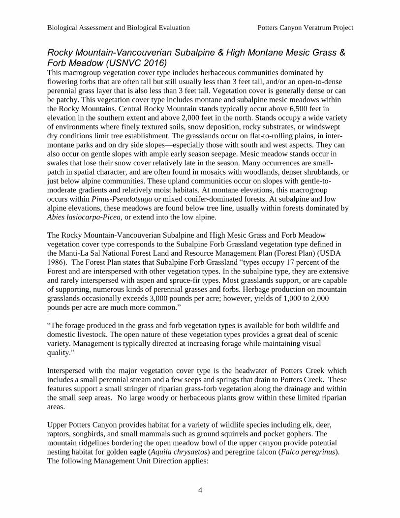
Rocky Mountain-Vancouverian Subalpine & High Montane Mesic Grass & Forb Meadow (USNVC 2016) This macrogroup vegetation cover type includes herbaceous communities dominated by
flowering forbs that are often tall but still usually less than 3 feet tall, and/or an open-to-dense
perennial grass layer that is also less than 3 feet tall. Vegetation cover is generally dense or can
be patchy. This vegetation cover type includes montane and subalpine mesic meadows within
the Rocky Mountains. Central Rocky Mountain stands typically occur above 6,500 feet in
elevation in the southern extent and above 2,000 feet in the north. Stands occupy a wide variety
of environments where finely textured soils, snow deposition, rocky substrates, or windswept
dry conditions limit tree establishment. The grasslands occur on flat-to-rolling plains, in inter-
montane parks and on dry side slopes—especially those with south and west aspects. They can
also occur on gentle slopes with ample early season seepage. Mesic meadow stands occur in
swales that lose their snow cover relatively late in the season. Many occurrences are small-
patch in spatial character, and are often found in mosaics with woodlands, denser shrublands, or
just below alpine communities. These upland communities occur on slopes with gentle-to-
moderate gradients and relatively moist habitats. At montane elevations, this macrogroup
occurs within Pinus-Pseudotsuga or mixed conifer-dominated forests. At subalpine and low
alpine elevations, these meadows are found below tree line, usually within forests dominated by
Abies lasiocarpa-Picea, or extend into the low alpine.
The Rocky Mountain-Vancouverian Subalpine and High Mesic Grass and Forb Meadow
vegetation cover type corresponds to the Subalpine Forb Grassland vegetation type defined in
the Manti-La Sal National Forest Land and Resource Management Plan (Forest Plan) (USDA
1986). The Forest Plan states that Subalpine Forb Grassland “types occupy 17 percent of the
Forest and are interspersed with other vegetation types. In the subalpine type, they are extensive
and rarely interspersed with aspen and spruce-fir types. Most grasslands support, or are capable
of supporting, numerous kinds of perennial grasses and forbs. Herbage production on mountain
grasslands occasionally exceeds 3,000 pounds per acre; however, yields of 1,000 to 2,000
pounds per acre are much more common.”
“The forage produced in the grass and forb vegetation types is available for both wildlife and
domestic livestock. The open nature of these vegetation types provides a great deal of scenic
variety. Management is typically directed at increasing forage while maintaining visual
quality.”
Interspersed with the major vegetation cover type is the headwater of Potters Creek which
includes a small perennial stream and a few seeps and springs that drain to Potters Creek. These
features support a small stringer of riparian grass-forb vegetation along the drainage and within
the small seep areas. No large woody or herbaceous plants grow within these limited riparian
areas.
Upper Potters Canyon provides habitat for a variety of wildlife species including elk, deer,
raptors, songbirds, and small mammals such as ground squirrels and pocket gophers. The
mountain ridgelines bordering the open meadow bowl of the upper canyon provide potential
nesting habitat for golden eagle (Aquila chrysaetos) and peregrine falcon (Falco peregrinus).
The following Management Unit Direction applies:

Biological Assessment and Biological Evaluation Potters Canyon Veratrum Project
5
Range Management (RNG). No specific special-use management direction. In general,
management activities seek to maintain or improve range conditions for domestic livestock and
wildlife. Permit special uses that are compatible with the objectives of the unit and allow
appropriate motorized access. Structural watershed improvements damaged by surface-
disturbing activities will be rehabilitated (pages III–79).
Riparian (RPN) Management in Potters Canyon. Permit special uses that are complementary
and compatible with the kind and level of development within the unit (pages III–73).
Utility Corridor (UC) Management (traverses the northeastern boundary of the project area).
No specific special use management direction. In general, management activities within these
linear corridors strive to be compatible with the management goals of the adjacent units (pages
III–95).
Evaluated Species Information
Threatened, Endangered, Proposed, and Candidate Species Table 1 displays all animal and plant species designated as threatened, endangered, or candidate
by the USFWS that could occur within Sanpete County, Utah. The current Sanpete County list
provided by the USFWS (https://ecos.fws.gov/ecp0/reports/species-by-current-range-
county?fips=49039) was used to identify potential species, and the 2016 USFWS online project
planning tool was used to identify potential species conflicts within the project area
(https://ecos.fws.gov/ipac/project) (USDI 2016a). The table also describes habitats occupied by
the threatened and endangered animals and plants, and the general distribution of their habitats.
The threatened or endangered species that do not occur or have suitable habitat in or near the
proposed project area are identified in Table 1 and will not be considered further in this BA/BE.
Sensitive Plant, Terrestrial Wildlife, and Aquatic Species Table 2 lists the Intermountain Regional Forester’s list of sensitive animal and plant species that
could occur on the Manti Division of the Forest within the project area or that could have
suitable habitat within the proposed project’s area of potential effects. Sensitive wildlife and
plant species that have been determined not to occur or do not have suitable habitat in the project
area will not be considered further in this BA/BE.
Pre-field Review and Survey Information A pre-field review of sensitive species was completed by reviewing the Forest Service Region 4
Sensitive Species List (USDA Forest Service 2016), site-specific Ferron/Price Ranger District
data, and the Forest Plan (USDA, Forest Service 1986), as well as conducting literature reviews.
A field reconnaissance was conducted by the botanist on July 14, 2016, to determine plant
communities and species within the project area, and a site visit was conducted by the wildlife
biologist on July 7, 2016, to evaluate habitat types and their suitability for wildlife species of
concern.

Biological Assessment and Biological Evaluation Potters Canyon Veratrum Project
6
Table 1. Federally listed and candidate animal and plant species that could occur within the
Potters project area in Sanpete County, Utah (USDI 2016b), and their consideration
in this biological assessment and biological evaluation (BA/BE).
SPECIES SPECIES STATUS SPECIES OCCURRENCE AND CONSIDERATION
IN THIS BA/BE
Terrestrial Wildlife Species
Yellow-billed Cuckoo
Coccyzus americanus
Threatened
Not Considered in detail (Unlikely to Occur).
In Utah nesting habitats are found at elevations
between 2,500 and 6,000 feet. They appear to
require large tracts (100–200 acres) of
contiguous riparian nesting habitat (Parrish et al.
2002). The project area is at approximately
9,000–10,200 feet elevation. There are no large
contiguous tracts of riparian habitat in the
vicinity of the project area. There is no critical
habitat for this species within the project area. It
is my determination that the proposed project
will have No Effect on the yellow-billed cuckoo
or its habitat; thus, it will not be carried forward
for further analysis.
Aquatic Wildlife Species
Bonytail
Gila elegans
Endangered Not Considered in detail (Unlikely to Occur).
Historically, the bonytail existed in warm water
reaches of larger rivers in the Colorado River
Basin; it is considered to be adapted to pools and
eddies of mainstream rivers. It has been
extirpated from most of its historic range.
Currently, a small number of wild adults exist in
Lake Mohave in the lower Colorado River basin,
and there are small numbers of wild individuals
in the Green River and in subbasins of the upper
Colorado River basin (USDI USFWS 2002a).
The bonytail has not been located on the Forest,
and the proposed project will not affect any
streams that could cause any downstream effects
to the bonytail. It is my determination that the
proposed project will have No Effect on the
bonytail or its habitat; therefore, it will not be
carried forward for further analysis.

Biological Assessment and Biological Evaluation Potters Canyon Veratrum Project
7
SPECIES SPECIES STATUS
SPECIES OCCURRENCE AND CONSIDERATION
IN THIS BA/BE
Colorado Pikeminnow
Ptychocheilus lucius
Endangered Not Considered in detail (Unlikely to Occur).
The Colorado pikeminnow is endemic to the
Colorado River basin, and its range historically
extended from the Green River in Wyoming to
the Gulf of California. The species was
widespread and abundant in warm-water rivers
and tributaries. It is a long-distance migrator
(hundreds of kilometers to and from spawning
areas). Adults require deep pool and eddie
habitats in streams that have high spring flows.
Currently, this species occurs in Utah in the
Green River from Lodore Canyon to the
confluence of the Colorado River (USDI
USFWS 2002b). The Colorado pikeminnow has
not been located on the Forest, and the proposed
project will not affect any streams that could
cause any downstream effects to this species. It
is my determination that the proposed project
will have No Effect on the Colorado
pikeminnow or its habitat, so it will not be
carried forward for further analysis.
Humpback Chub
Gila cypha
Endangered Not Considered in detail (Unlikely to Occur).
The humpback chub is restricted to deep, swift
mainstreams and large tributaries in relatively
inaccessible canyons of the Colorado River
basin. Adults require eddies and sheltered
shorelines in streams that maintain high spring
flows that flush sediments from spawning areas
and form gravel deposits used for spawning.
Young require low-velocity shoreline habitats.
Currently, there are six known extant
populations that are located in the upper
Colorado River, Yampa River, and Little
Colorado River (USDI USFWS 2002c). The
humpback chub has not been located on the
Forest, and the proposed project will not affect
any streams that could cause any downstream
effects to this species. It is my determination that
the proposed project will have No Effect on the
humpback chub or its habitat. The speices will
not be carried forward for further analysis.

Biological Assessment and Biological Evaluation Potters Canyon Veratrum Project
8
SPECIES SPECIES STATUS
SPECIES OCCURRENCE AND CONSIDERATION
IN THIS BA/BE
Razorback Sucker
Xyrauchen texanus
Endangered Not Considered in detail (Unlikely to Occur).
Historically, the razorback sucker was widely
distributed in warm-water reaches of the
Colorado River and its tributaries from
Wyoming to Mexico. Adults require deep pools,
eddies, and backwaters in spring; shallow water
associated with sandbars in summer; and low-
velocity pools and eddies in winter. Young
require quiet, warm, shallow water found at
tributary mouths and in coves or shorelines in
reservoirs. Currently, within the upper Colorado
River basin this species is only found in small
numbers in the middle Green River, between the
confluence of the Duchesne and Yampa Rivers,
and in the lower reaches of those two tributaries
(USDI USFWS 2002d). The razorback sucker
has not been located on the Forest and the
proposed project will not affect any streams that
could cause any downstream effects to this
species. It is my determination that the proposed
project will have No Effect on the razorback
sucker or its habitat; therefore, this species will
not be carried forward for further analysis.
Plant Species
Heliotrope Milkvetch
Astragalus limnocharis var. montii
Threatened Not Considered in detail (Unlikely to Occur). This species is not known to occur within the
project area (Anderson 2016a). Heliotrope
milkvetch grows in the subalpine zone from
10,500 to 11,000 feet in shale barrens of the
Flagstaff limestone formation. It can be found in
openings and wind-swept limestone breaks with
other mat-forming species (Tilley et al. 2010).
The project area is approximately 10,250 feet in
elevation and moderately to heavily vegetated
with alpine meadow plant species with little to
no exposed limestone noted. There is no suitable
habitat for this species within the project area,
therefore it is my determination that the proposed
project will have No Effect on Heliotrope
milkvetch or its habitat, so further analysis is
necessary for this species.
Biological Assessment and Biological Evaluation Potters Canyon Veratrum Project
9
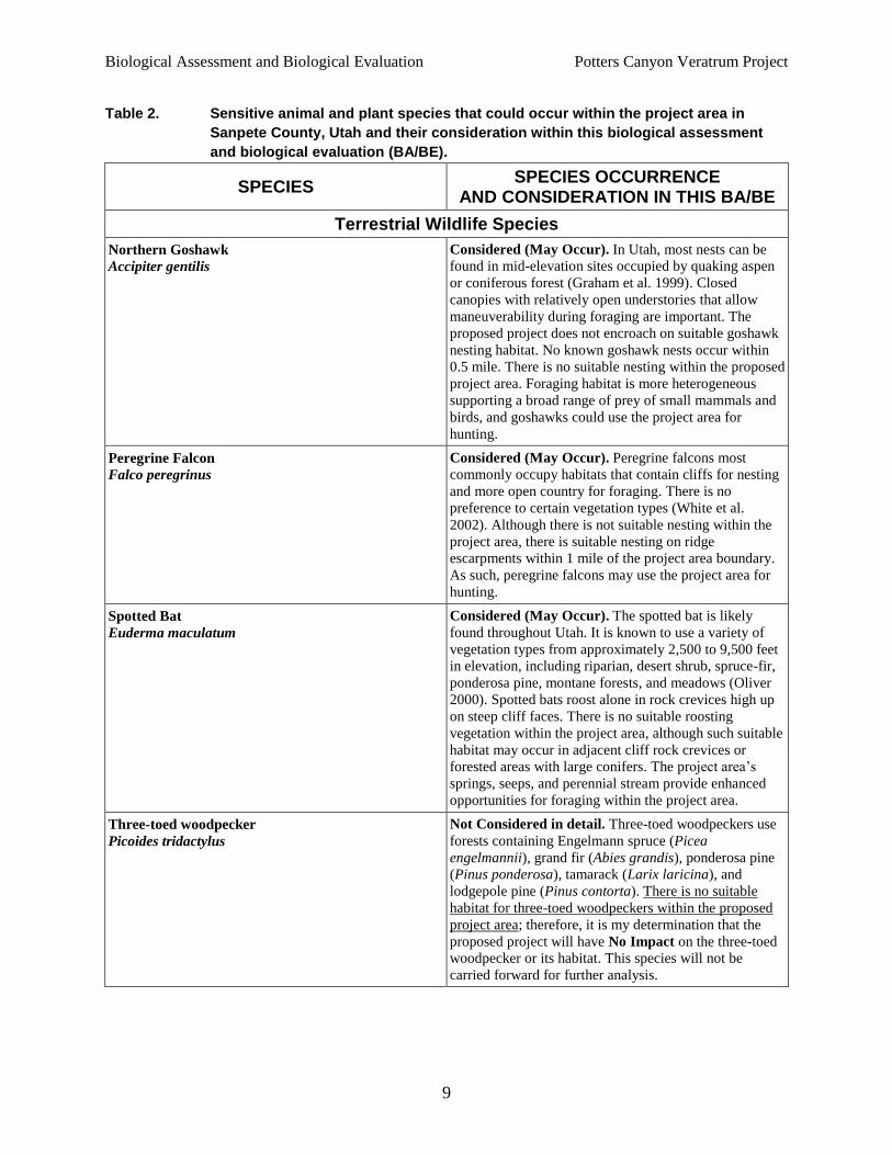
Table 2. Sensitive animal and plant species that could occur within the project area in
Sanpete County, Utah and their consideration within this biological assessment
and biological evaluation (BA/BE).
SPECIES SPECIES OCCURRENCE
AND CONSIDERATION IN THIS BA/BE
Terrestrial Wildlife Species
Northern Goshawk
Accipiter gentilis
Considered (May Occur). In Utah, most nests can be
found in mid-elevation sites occupied by quaking aspen
or coniferous forest (Graham et al. 1999). Closed
canopies with relatively open understories that allow
maneuverability during foraging are important. The
proposed project does not encroach on suitable goshawk
nesting habitat. No known goshawk nests occur within
0.5 mile. There is no suitable nesting within the proposed
project area. Foraging habitat is more heterogeneous
supporting a broad range of prey of small mammals and
birds, and goshawks could use the project area for
hunting.
Peregrine Falcon
Falco peregrinus
Considered (May Occur). Peregrine falcons most
commonly occupy habitats that contain cliffs for nesting
and more open country for foraging. There is no
preference to certain vegetation types (White et al.
2002). Although there is not suitable nesting within the
project area, there is suitable nesting on ridge
escarpments within 1 mile of the project area boundary.
As such, peregrine falcons may use the project area for
hunting.
Spotted Bat
Euderma maculatum
Considered (May Occur). The spotted bat is likely
found throughout Utah. It is known to use a variety of
vegetation types from approximately 2,500 to 9,500 feet
in elevation, including riparian, desert shrub, spruce-fir,
ponderosa pine, montane forests, and meadows (Oliver
2000). Spotted bats roost alone in rock crevices high up
on steep cliff faces. There is no suitable roosting
vegetation within the project area, although such suitable
habitat may occur in adjacent cliff rock crevices or
forested areas with large conifers. The project area’s
springs, seeps, and perennial stream provide enhanced
opportunities for foraging within the project area.
Three-toed woodpecker
Picoides tridactylus
Not Considered in detail. Three-toed woodpeckers use
forests containing Engelmann spruce (Picea
engelmannii), grand fir (Abies grandis), ponderosa pine
(Pinus ponderosa), tamarack (Larix laricina), and
lodgepole pine (Pinus contorta). There is no suitable
habitat for three-toed woodpeckers within the proposed
project area; therefore, it is my determination that the
proposed project will have No Impact on the three-toed
woodpecker or its habitat. This species will not be
carried forward for further analysis.

Biological Assessment and Biological Evaluation Potters Canyon Veratrum Project
10
SPECIES SPECIES OCCURRENCE
AND CONSIDERATION IN THIS BA/BE
Aquatic Wildlife Species
Western Boreal Toad
Bufo boreas boreas
Not Considered in detail (Unlikely to Occur). The
western toad (Bufo boreas boreas), inhabits western
Canada and much of the western (especially
northwestern) United States. It occurs throughout most
of Utah and can be found in a variety of habitats,
including slow-moving streams, wetlands, desert springs,
ponds, lakes, meadows, and woodlands (UDNR 2015).
There are a few seeps and springs, as well as a perennial
stream, within the project area, but no toads have been
detected within the general project area. The closest
known population of boreal toad is 8 miles from the
project area on East Mountain (USDA 2015a). No
wetlands, seeps, springs, ponds, or streams will be
impacted by the proposed action. It is my determination
that the proposed project will have No Impact on the
western boreal toad or its habitat, and this species will
not be carried forward for further analysis.
Plant Species
Arizona willow
Salix arizonica
Not Considered in detail (Not Likely). This species
occurs in riparian communities along streambanks at
elevations ranging between 8,000 and 10,500 feet.
Arizona willow occurs in a small population miles
beyond the project area (Anderson 2016b). Habitat
documented within the project area is not consistent with
habitat or documented occurrences of this species which
requires riparian conditions. Therefore, it is my
determination that the proposed project will have No
Impact on Arizona willow or its habitat. No further
analysis is necessary for this species.
Canyon sweetvetch
Hedysarum occidentale var. canone
Considered (May Occur, Not Likely). This species is
found in sagebrush shrubland, desert grasslands, pinyon
pine, and Douglas fir vegetation communities at
elevations ranging from 5,600 to 8,700 feet. Habitat
within the area of analysis is neither consistent with
habitat typically accompanying this species nor within
the elevational range where canyon sweetvetch has been
documented (Welsh et al. 2003). As there is no suitable
habitat for this species within the project area, it is my
determination that the proposed project will have No
Impact on Canyon sweetvetch or its habitat. No further
analysis is necessary for this species.

Biological Assessment and Biological Evaluation Potters Canyon Veratrum Project
11
SPECIES SPECIES OCCURRENCE
AND CONSIDERATION IN THIS BA/BE
Creutzfeldt-flower cryptanth
Cryptantha creutzfeldtii
Not Considered in detail (Not Likely). Habitat that
supports this species occurs in Mancos Shale in
shadscale- and mat-atriplex-dominated vegetation
communities at elevations ranging from 5,500 to 6,500
feet (Spahr et al. 1991). There is no suitable habitat for
this species within the project area; therefore, it is my
determination that the proposed project will have No
Impact on Creutzfeldt-flower cryptanth.
Link Trail columbine
Aquilegia flavescens var. rubicunda
Considered (May Occur, Not Likely). This plant is
known only from the mountains of Emery and Sevier
County where it is associated with seeps emerging
from Mesa Verde Group sandstone formations
(NatureServe 2015a, USDA 2015b). Site locations tend
to be near or adjacent to coal strata (NatureServe
2015a). Albee et al. (1998 and Welsh et al. (2003) state
that this plant may also occur along perennial wetland
sites on the east side of the Wasatch Plateau at
elevations of up to 10,300 feet. This species has also
been observed in mixed conifer forests and mixed
montane communities (Welsh et al. 2003). The closest
occurrence of Mesa Verde Group sandstone is east of
Joe’s Valley in Cottonwood Canyon and Straight
Canyon approximately 13 miles southwest in Emery
County (UGS 2016). No coal strata have been
identified in the local North Horn Formation or the
local Mass Wasting Deposits Formation. Therefore, no
suitable habitat is available within or adjacent to the
project area, nor has any populations been identified
within Sanpete County. NatureServe (2015a) that only
six occurrences are known and believed to be extant in
Emery and Sevier Counties. Plants growing on Mesa
Verde Group outcrops with coal seams in Bear
Canyon, 12 miles east of the project area, are the
closest known population (NatureServe 2015a). It is
my determination that the proposed project will have
No Impact on the Link Trail columbine or its habitat.
This species will not be carried forward for further
analysis.
Maguire campion
Silene petersonii
Not Considered in detail (Not Likely). This species
occurs within limestone barrens on the Flagstaff
Limestone and Claron Formation, mainly along the
margins of plateaus. The elevation at which this species
is found ranges from 6,700 to 10,800 feet (Welsh et al.
2003). The project area is situated within this elevational
range, although the site is moderately to heavily
vegetated with alpine meadow plant species with little-
to-no exposed limestone. There is no suitable habitat for
this species within the project area; therefore, it is my
determination that the proposed project will have No
Impact on Maguire campion or its habitat. No further
analysis is necessary for this species.

Biological Assessment and Biological Evaluation Potters Canyon Veratrum Project
12
SPECIES SPECIES OCCURRENCE
AND CONSIDERATION IN THIS BA/BE
Musinea groundsel
Senecio musiniensis
Not Considered in detail (Not Likely). This species
occurs on ridge tops on Flagstaff limestone barrens and
talus slopes elevations ranging from 9,700 to 10,800 feet
in elevation (NatureServe 2015b). The project area is
situated within this elevational range, although the site is
moderately to heavily vegetated with alpine meadow
plant species with little to no exposed limestone. There is
no suitable habitat for this species within the project
area; therefore, it is my determination that the proposed
project will have No Impact on Musinea groundsel or its
habitat. No further analysis is necessary for this species.
Untermann’s daisy
Erigeron untermannii
Considered (May Occur, Not Likely). This species is
known only from Duchesne County, where it is
considered endemic (NatureServe 2015c). This plant
occurs on calcareous shales and sandstones mainly of the
Uinta and Green River formations from about 6,800 to
9,500 feet in elevation in association with various plant
communities including sagebrush, pinyon-juniper,
limber pine, (NatureServe 2015c), Conversely, Albee et
al. (1998) states that its habitat is characterized by
meadows and steep escarpments, commonly in the
Flagstaff formation at elevations ranging from 9,500 to
10,500 feet. The project area is greater than 35 miles
from the only known occurrences in Duchesne County.
Upper Potters Canyon is in the North Horn Formation or
the local Mass Wasting Deposits (UGS 2016). The
closest Flagstaff Formation outcrop is on the south ridge
of Bulger Canyon, approximately 2 miles south of the
project area (UGS 2016). No suitable habitat is available
within or adjacent to the project area, and no populations
have been identified outside Duchesne County. It is my
determination that the proposed project will have No
Impact on the Untermann’s daisy or its habitat. This
species will not be carried forward for further analysis.
Species Descriptions and Analysis of Effects This analysis of effects is based on the existing conditions within the project area. This analysis
reviews the potential “direct and indirect effects” of the proposed project on threatened,
endangered, and sensitive species, and the expected cumulative effects that could potentially
accrue to effect threatened, endangered, and sensitive species if project activities add
cumulatively to other past, present, or reasonably foreseeable future actions.
Threatened, Endangered, Proposed, and Candidate Species No federally listed species were carried forward through this analysis because there are no
suitable habitats, no critical habitats, and no known occurrences of these species within the
proposed project area.

Biological Assessment and Biological Evaluation Potters Canyon Veratrum Project
13
Sensitive Plant, Terrestrial Wildlife, and Aquatic Species
Northern Goshawk A Conservation Strategy and Agreement for the Management of Northern Goshawk Habitat in
Utah was developed in 1999 (USDA Forest Service 2000). The Utah Northern Goshawk Forest
Plan Amendment was signed on March 14, 2000 (USDA Forest Service 2000) and the decision
for Forest Plan Amendment UTMLEA2003-01 for the Manti-La Sal National Forest Land
Management Resource Plan was signed on June 13, 2003. These decisions amend the goals,
objectives, standards, guidelines, and monitoring requirements established in the current land and
resource management plan (USDA Forest Service 1986).
Northern goshawks (Accipiter gentilis) have been found in a variety of forest ecosystems
including lodgepole pine, aspen, ponderosa pine, Douglas-fir, and mixed forests throughout
much of the northern hemisphere. Goshawk nest sites are usually located in dense, mature forests
with large trees, near water, and on benches of relatively little slope (Graham et al. 1999). Closed
canopies are important for protection and thermal cover, and open understories are important for
maneuverability during foraging. Data (district records) collected from the Wasatch Plateau
between 1989 and 2000 show that over 80 percent of nothern goshawk nests (n=48) are in stands
with a mixture of aspen and conifer species, with the remaining nest stands comprised of mixed-
conifer (primarily Engelmann spruce/sub-alpine fir) without aspen. Sixty-five percent of all nests
have been in aspen trees, with proportionally fewer in Douglas fir and spruce. Nests are often
used year after year, but nest stands usually contain a number of alternate nests.
Suitable northern goshawk habitat is often heterogeneous and supports a broad range of prey
species, particularly small mammals and birds including rabbits, squirrels, chipmunks, grouse,
woodpeckers, jays, and robins. Important forest components in Utah include snags, multiple
canopies, and downed woody debris (Graham et al. 1999).
The northern goshawk population on the Forest appears to be stable. The northern goshawk
started to become a focal species on the Forest in the late 1980s, and the number of known
goshawk territories on the Forest has steadily increased since that time. Therefore, looking at the
number of known active nests over the years would give the impression that the Forest’s
northern goshawk population has steadily increased since the late 1980s. A better indication of
how the northern goshawk population is doing on the Forest would be the percent of monitored
nests that were occupied each year, which is illustrated in Figure 1.
Direct and Indirect Impacts No direct or indirect impacts are anticipated from the proposed project. The proposed project
area is in an open meadow. Possible foraging habitat could occur in the aspen stands outside of
the project area, and infrequent small mammal hunting forays may be made into the open
meadow. No impacts are expected for northern goshawk nesting habitat, because no known nests
occur in the harvest area and there is no suitable nesting habitat. The minimal level of human
activity and restricted time frame of the harvest (late summer-early autumn) may temporarily
displace birds to adjacent areas, but it would not affect overall hunting opportunities for the
goshawk.

Biological Assessment and Biological Evaluation Potters Canyon Veratrum Project
14
Figure 1. Percent of monitored northern goshawk nests that were occupied on the Manti
Division of the Manti-La Sal National Forest from 1995 through 2007.
Surveys were not conducted because no suitable nesting habitat is found within the project area.
During on-site visits the interdisiplinary team determined that the project area did not have
suitable nesting habitat.
Cumulative Effects The cumulative analysis area for the northern goshawk for this project is the upper Potters Creek
watershed terminating at Potters Pond diversion. Past, present and reasonably foreseeable actions
within this analysis area are presented as Appendix A. Past activities have affected
approximately 609 acres of forested habitat. This disturbance complied with the Manti-LaSal
National Forest Northern Goshawk Forest Plan Amendment (2003). The Standards and
Guidelines within the amended Forest Plan has resulted in goshawk populations and a stable
trend in nest occuppancy. Future planned timber activities could affect an additional 282 acres of
forested habitat. Prior to approval the design activities must demonstrated compliance with the
amended Forest Plan Standards and Guidelines, and thus, maintain the stable nest occuppancy
trend. The only past and present action affecting open grass-forb or sagebrush grassland habitats
is the approved grazing for 900 ewes/lambs of the Potters Canyon Grazing Allotment that covers
the entire cumulative effects analysis area. The open grass-forb and sagebrush grassland habitats
provide approximately 2,103 acres of potential hunting habitat for the Northern goshawk within
the cumulative effects area. The proposed project would disturb an additional 70-100 acres of
such habitat (<5%); however the design features for restoration are expected to re-establish the
native plant community at the harvest sites and thus no cumulative effect due to loss of grass-
forb habitat is expected. In addition, the project will convert 70-100 acres of marginal prey
habitat (monotypic Veratrum stands) to better habitat for prey species, possibly offsetting some
local livestock grazing effects to habitat. Based on this evaluation, the proposed Potters Canyon

Biological Assessment and Biological Evaluation Potters Canyon Veratrum Project
15
Veratrum Harvest Project would have no cumulative impact on the Northern goshawk, nor affect
this species Forest-wide stable trend.
Determination The proposed project would not have an effect on northern goshawk population stability within
the Manti-LaSal National Forest, and would thus have No Impact on the northern goshawk,.
Peregrine Falcon The peregrine falcon occurs throughout much of North America from the subarctic boreal forests
of Alaska and Canada south to Mexico. The peregrine falcon nests from central Alaska, the
central Yukon Territory, and northern Alberta and Saskatchewan east to Canada’s Maritime
provinces and south (excluding coastal areas north of the Columbia River in Washington and
British Columbia) throughout western Canada and the United States to Baja California, Sonora,
and the highlands of central Mexico.
The species’ preferred nesting habitat is on cliff faces with recesses or protected shelves, but it
will occasionally use abandoned stick nests of other species. The nest is not built; a scrape or
depression is dug into gravel on a cliff ledge. Some peregrine falcons have accepted manmade
structures as breeding sites.
A wide variety of habitats are used for foraging, including riparian woodlands, open country near
rivers and marshes, coniferous and deciduous forest edges, shrub lands, and prairies. Peregrine
falcons prey on various birds including pigeons, shorebirds, waterfowl, grouse, and other small-
to medium-sized terrestrial birds. Peregrine falcons may travel up to 18 miles from the nest site
to hunt for food; however, a 10-mile radius around the nest is an average hunting area, and 80
percent of foraging occurs within 1 mile of the nest (Spahr et al. 1991).
Direct and Indirect Impacts No direct or indirect impacts are anticipated from the proposed project. The proposed project
area is an open meadow with no suitable nesting habitat. No eyries have been identified on
ridgeline escarpments within the general project area. The proposed project would not affect any
potential nesting in the area as harvest activities would not commence until August—after the
typical nesting season. Possible bird and small mammal foraging habitat could occur in the open
meadow. The minimal level of human activity and restricted time frame of the harvest (late
summer-early autumn) could temporarily displace birds to adjacent areas, but it would not affect
overall hunting opportunities for the peregrine falcon.
Cumulative Effects The cumulative analysis area for the peregrine falcon for this project is the upper Potters Creek
watershed terminating at Potters Pond diversion. Past, present and reasonably foreseeable
actions within this analysis area is presented as Appendix A. Past activities have affected
approximately 609 acres of forested habitat, and future planned timber activities could affect an
additional 282 acres of forested habitat. However, none of these projects have or would affect
cliffs or steep escarpments considered prime habitat for eyries. The only past and present action
affecting open grass-forb or sagebrush grassland habitats is the approved grazing for 900
ewes/lambs of the Potters Canyon Grazing Allotment that covers the entire cumulative effects

Biological Assessment and Biological Evaluation Potters Canyon Veratrum Project
16
analysis area. The open grass-forb and sagebrush grassland habitats provide approximately
2,103 acres of potential hunting habitat for the peregrine falcon within the cumulative effects
area. The proposed project would disturb an additional 70-100 acres of such habitat (<5%);
however the design features for restoration are expected to re-establish the native plant
community at the harvest sites and thus no cumulative effect due to loss of grass-forb habitat is
expected. In addition, the project will convert 70-100 acres of marginal prey habitat (monotypic
Veratrum stands) to better habitat for prey species, possibly offsetting some potential local
livestock grazing effects to habitat. Based on this evaluation, the proposed Potters Canyon
Veratrum Harvest Project would have no cumulative impact on the peregrine falcon, nor affect
this species Forest-wide stable trend.
Determination The proposed project would have no direct or indirect effect on the peregrine falcon, nor would
there be any cumulative effect to the potential falcon use within the cumulative analysis area. As
such, the project would have no effect on the increasing population trend in Utah and, thus,
would have No Impact on the peregrine falcon.
Spotted Bat Currently, the spotted bat (Euderma maculatum) is known to be distributed across large areas of
western North America from southern British Columbia to the central Mexican state of
Queretaro (Luce and Keinath 2007).
The spotted bat uses cracks, crevices, and caves as roost sites. These roost sites are usually high
in fractured rock cliffs. Availability of suitable roost sites and human disturbance are the limiting
factors to this species’ success (Spahr et al. 1991). It can be found at elevations ranging from
approximately 2,800 to 9,000 feet.
Spotted bats have been found foraging in many different habitats including sub-alpine mountain
meadows, forest openings, pinyon/juniper woodlands, low upland slopes of juniper and
sagebrush, the rims of cliffs, riverine/riparian habitat along rivers, old agricultural fields, and
riparian habitat associated with small- to mid-sized streams in narrow canyons, wetlands, and
meadows (Luce and Keinath 2007). Foraging activities takes place near or over water, which is a
function of prey availability. The spatial relationship between roosting and foraging habitat is
especially important for the spotted bat, whose distribution is limited by the occurrence of
suitable roosting and foraging habitat within travel distance of each other (Luce and Keinath
2007). During summer bats may travel from roosts in desert-scrub to forage in high-elevation
meadows, returning to roosts within an hour of dawn. Males and females are capable of long-
distance flight; thus foraging ranges can be large. Long foraging distances may be explained by a
lack of suitable high-cliff roost sites near referred foraging sites (Luce and Keinath 2007).
Spotted bats are strong fliers and forage primarily alone from 6 to 165 feet above ground.
Spotted bats echolocate at a pitch audible to humans but not audible to prey until these bats are
too close for prey to evade them. Spotted bats forage primarily on moths, but have been found to
consume beetles, and they do not appear to select particular moth species (Luce and Keinath
2007).

Biological Assessment and Biological Evaluation Potters Canyon Veratrum Project
17
Spotted bats breed in late February or early April and give birth to one altricial young in May or
June (Luce and Keinath 2007). Spotted bats do not congregate in nursery colonies as do other
bats but remain solitary throughout the year.
The spotted bat drinks on the fly by skimming the surface of open water sources such as ponds,
spring ponds, lakes, and tanks. This bat needs a short swoop zone in order to water on the fly and
is one of several species that can use a water source such as a cattle stock tank (Luce and Keinath
2007).
Direct and Indirect Effects No direct or indirect impacts to spotted bat are anticipated from the proposed project. The
spotted bat could potentially use cracks and crevices of rock cliffs or large conifers for roosting
in the general area, although in project area vicinity such habitat is at the upper elevational limit
of the species. The project’s harvest activities will be limited to open meadow habitat, which will
eliminate any potential conflict with spotted bat roosting or roosting habitat. Open meadows are
spotted bat foraging habitat, and this species will travel extensive distances to forage. These bats
nocturnally forage for insects in riparian habitat associated with small- to mid-sized streams.
Open water sources (a few small springs/seeps and a small perennial stream) exist within the
open meadow of the project area. Harvest activities will be limited to existing Veratrum patches
and will avoid existing water sources. In addition, harvest activities will occur during the
daylight and thus avoid any conflict with spotted bat foraging.
Cumulative Effects The cumulative analysis area for the spotted bat for this project is the upper Potters Creek
watershed terminating at Potters Pond diversion. Past, present and reasonably foreseeable
actions within this analysis area is presented as Appendix A. Past activities have affected
approximately 609 acres of forested habitat, and future planned timber activities could affect an
additional 282 acres of forested habitat. However, none of these projects have or would affect
caves or the cracks and crevices of highly fractured cliff faces considered prime habitat for
spotted bat roosting. The only past and present action affecting open grass-forb and sagebrush
grassland habitats is the approved grazing for 900 ewes/lambs of the Potters Canyon Grazing
Allotment that covers the entire cumulative effects analysis area. The open grass-forb and
sagebrush grassland habitats, in addition to the limited open water habitat, provide approximately
2,119 acres of potential foraging habitat for the spotted bat within the cumulative effects area.
The proposed project would disturb an additional 70-100 acres of such habitat (about 3%);
however the design features for restoration are expected to re-establish the native plant
community at the harvest sites and thus no cumulative effect due to loss of grass-forb habitat is
expected. In addition, the project will convert 70-100 acres of marginal prey habitat (monotypic
Veratrum stands) to better habitat for prey species, possibly offsetting some local livestock
grazing effects to habitat. Based on this evaluation, the proposed Potters Canyon Veratrum
Harvest Project would have no cumulative impact on the spotted bat, nor affect this species
Forest-wide stable trend.
Determination Although no information is available on distribution and population trends of the spotted bat in
the Manti-LaSal Forest, the project will not affect potential roosting habitat or nocturnal

Biological Assessment and Biological Evaluation Potters Canyon Veratrum Project
18
foraging. Thus the proposed project would have No Impact on the spotted bat or its trend in the
Manti-LaSal Forest.
Determination of Effects
This section will discuss determination of effects to animal and plant species considered in this
document. Table 3 shows a summary of determinations for each species.
Table 3. Summary of determination of effects.
SPECIES STATUS ADVERSELY IMPACTED
NOT IMPACTED
SUMMARY COMMENTS
Bonytail chub TES or
proposed X
Species occurs in Colorado River basin, but
project would not affect downstream water
quality.
Colorado
pikeminnow
TES or
proposed X
Species occurs in Colorado River basin, but
project would not affect downstream water
quality.
Humpback
chub
TES or
proposed X
Species occurs in Colorado River basin, but
project would not affect downstream water
quality.
Razorback
sucker
TES or
proposed X
Species occurs in Colorado River basin, but
project would not affect downstream water
quality.
Yellow-billed
cuckoo
TES or
proposed X
Species does not occur in the project area, and no
critical habitat occurs in or near the project area.
Heliotrope
milkvetch
TES or
proposed X
Species does not occur in the project area, and
does not have critical habitat in or near the project
area.
Northern
goshawk Sensitive X
Species has no known nests in the project area,
and there is no suitable nesting habitat in project
area. Suitable habitat would be restored.
Peregrine
falcon Sensitive X Project would not affect breeding habitat.
Spotted bat Sensitive X Project would not affect roosting habitat or
foraging opportunities.
Arizona
willow Sensitive X
Species does not occur in project area and suitable
habitat does not occur in project area.
Canyon
sweetvetch Sensitive X
Species does not occur in project area and suitable
habitat does not occur in project area.
Creutzfeldt-
flower
cryptantha
Sensitive X Species does not occur in project area and suitable
habitat does not occur in project area.
Maguire
campion Sensitive X
Species does not occur in project area and suitable
habitat does not occur in project area.
Musinea
groundsel Sensitive X
Species does not occur in project area and suitable
habitat does not occur in project area.
Link Trail
columbine Sensitive X
Species does not occur in project area and suitable
habitat does not occur in project area.
Untermann’s
daisy Sensitive X
Species does not occur in project area and suitable
habitat does not occur in project area.

Biological Assessment and Biological Evaluation Potters Canyon Veratrum Project
19
Threatened, endangered, proposed, and candidate species
Aquatic Wildlife Species The USFWS lists four fish species that could occur or have suitable habitat in Sanpete County,
Utah. These four fish species do not occur on Forest System lands, but they do occur within the
Colorado River basin. Tributaries within the proposed project area drain into the Colorado River
basin; however, this project will not impact stream quality or downstream water flows.
Therefore, is it my determination that the proposed Potters Canyon Veratrum Harvest Project
would have No Effect on the following federally listed and candidate fish species: bonytail chub,
Colorado pikeminnow, humpback chub, and razorback sucker.
Terrestrial Wildlife Species The USFWS lists one wildlife species that could occur or have suitable habitat in Sanpete
County, Utah. This species does not occur within the project area and does not have critical
habitat in or near the project area. Therefore, it is my determination that the proposed Potters
Canyon Veratrum Harvest Project would have No Effect on yellow-billed cuckoo.
Plant Species The USFWS lists one plant species that could occur or have suitable habitat in Sanpete County,
Utah. This species does not occur within the project area and does not have critical habitat in or
near the project area. Therefore, it is my determination that the proposed Potters Canyon
Veratrum Harvest Project would have No Effect on heliotrope milkvetch.
Sensitive Terrestrial Wildlife, Plant, and Aquatic Species
Terrestrial Wildlife Species The Intermountain Regional Forester lists five sensitive wildlife species that could occur within
this portion of the Manti Division of Forest. Boreal toad and three-toed woodpecker do not have
suitable habitat and have not been detected within the project area; therefore, they were not
carried forward in this analysis. The determinations for the northern goshawk, peregrine falcon,
and spotted bat follow.
Northern Goshawk There would be no direct or indirect impacts on northern goshawk nesting or foraging habitat
because no known nests occur in the harvest areas and there is no suitable nesting habitat there.
The minimal level of human activity and restricted time frame of the harvest (late summer-early
autumn) may temporarily displace birds to adjacent areas, but they would not affect overall
hunting opportunities for northern goshawk. All harvest patches will be restored to native
vegetation within a year, and is expected to improve local habitat for small mammal prey
species. Therefore, it is my determination that the proposed Potters Canyon Veratrum Harvest
Project would have No Impact on the northern goshawk or its habitat.
Peregrine Falcon The proposed project area occurs in an open meadow with no suitable peregrine falcom nesting
habitat. Although no eyries have been identified on ridgeline escarpments within the general

Biological Assessment and Biological Evaluation Potters Canyon Veratrum Project
20
project area, the proposed project would not affect any potential nesting in the area as harvest
activities would not commence until August, which is after the typical nesting season. Northern
goshawk could forage in the open meadows of the proposed harvest area for birds and small
mammals; however, the minimal level of human activity and restricted time frame of the harvest
(late summer-early autumn) could temporarily displace birds to adjacent areas, but it would not
affect overall hunting opportunities for the peregrine falcon. All harvest patches will be restored
to native vegetation within a year, which is expected to improve local habitat for small mammal
prey species. Therefore, it is my determination that the proposed Potters Canyon Veratrum
Harvest Project would have No Impact on the peregrine falcon or its habitat.
Spotted Bat The proposed project harvest activities will be limited to open meadow habitat and thus eliminate
any potential conflict with roosting or roosting habitat. Open meadows are spotted bat foraging
habitat and spotted bats will travel extensive distances to forage. These bats nocturnally forage
for insects in riparian habitat associated with small- to mid-sized streams. Open water sources (a
few small springs/seeps and a small perennial stream) exist within the open meadow of the
project area. Harvest activities will be limited to existing Veratrum patches and will avoid
existing water sources. In addition, harvest activities will occur during the daylight, thus
avoiding any conflict with spotted bat foraging. Therefore, it is my determination that the
proposed Potters Canyon Veratrum Harvest Project would have No Impact on the spotted bat or
its habitat.
Plant Species The Forest ecologist lists seven sensitive species that could occur within this portion of the Manti
Division of the Forest. Arizona willow (Salix arizonica), canyon sweetvetch (Hedysarum
occidentale var. canone), Creutzfeldt-flower cryptantha (Cryptantha creutzfeldtii), Maguire
campion (Silene petersonii), Musinea groundsel (Senecio musiniensis), Link Trail columbine
(Aquilegia flavescens var. rubicunda), and Untermann’s daisy (Erigeron untermannii) do not
have suitable habitat or have not been detected within the project area and were not carried
forward in this analysis.
Forest Plan Consistency, Discussion of Extraordinary Circumstances, and Consideration of Best Available Science
Forest Plan Consistency A Forest Plan checklist was evaluated for this project. This project complies with applicable
Forestwide direction and standards and guidelines (USDA Forest Service 1986).
Consideration of Best Available Science The analysis in this BA/BE considers the best available science. The analysis focuses on species
present in the project area as determined through site visits, Forest inventories/surveys,
knowledge of the life history requirements of each species, and their occupancy of habitat types
similar to those on the Forest. Habitat suitability was determined through site visits and review of

Biological Assessment and Biological Evaluation Potters Canyon Veratrum Project
21
life histories and habitat requirements as outlined in Federal Register listings and/or species
recovery plans. The analysis includes a summary of the credible scientific evidence that is
relevant to evaluating reasonably foreseeable impacts. When appropriate, the conclusions were
based on scientific analysis that shows a thorough review of relevant scientific information, a
consideration of responsible opposing views, and the acknowledgment of incomplete or
unavailable information, scientific uncertainty, and risk. The relevant science considered for this
analysis consists of several key elements.
For wildlife and fisheries, the elements of science used were:
data from Forest-level inventories and monitoring,
field review, and
scientific literature (see Literature Cited section).
Irreversible and Irretrievable Commitments Irreversible means that something has been done that cannot be reversed, and the resource is
gone forever. No irreversible commitment of resources would occur from implementation of the
proposed action.
Irretrievable means there is a resource loss for a time. The loss or modification of wildlife habitat
is an irretrievable commitment of resources. The proposed root harvest of Veratrum of
approximately 10–25 acres per year and temporary road construction would result in short-term
irretrievable loss of existing habitat; however, the proven restoration techniques would
reestablish native vegetation communities within 1 year of harvest. As vegetation recovers, the
habitat also recovers. Habitat and its effectiveness would be retrieved over the long-term.
Viability of wildlife populations would not be at risk by implementing the proposed action.

Biological Assessment and Biological Evaluation Potters Canyon Veratrum Project
22
Literature Cited
Albee, B. J., L.M. Shultz, and S. Goodrich. 1998. Atlas of the vascular plants of Utah. Utah
Museum of Natural History, Salt Lake City. The Ecology Center, Utah State University,
Logan. Utah Museum of Natural History Occasional Publication No. 7.
Anderson, K. 2016a. Botanist, Manti-La Sal Nation Forest, Manti District. Personal
communication with Bridget Atkin, BIO-WEST, Inc., regarding heliotrope milkvetch.
7/13/2016.
Anderson, K. 2016b. Botanist, Manti-La Sal Nation Forest, Manti District. Personal
communication with Bridget Atkin, BIO-WEST, Inc., regarding Arizona willow.
7/11/2016.
Graham, R.T., R.L. Rodriguez, K.M. Paulin, R.L. Player, A.P. Heap, and R. Williams. 1999. The
northern goshawk in Utah: habitat assessment and management recommendations.
General Technical Report RMRS-GTR-22. USDA Forest Service, Rocky Mountain
Research Station, Ogden, Utah. 48 p.
Luce, R.J., and D. Keinath. 2007. Spotted bat (Euderma maculatum): a technical conservation
assessment [online]. US Department of Agriculture Forest Service, Rocky Mountain
Region. Location:
http://www.fs.usda.gov/Internet/FSE_DOCUMENTS/stelprdb5181916.pdf (accessed
11/28/2016).
NatureServe. 2015a. NatureServe Explore: An online encyclopedia of life [web application].
Version 6.1. NatureServe, Arlington, Virginia. Location: http://explorer.natureserve.org/
servlet/NatureServe?searchSpeciesUid=ELEMENT_GLOBAL.2.147987 (accessed
11/28/2016).
NatureServe. 2015b. NatureServe Explore: An online encyclopedia of life [web application].
Version 6.1. NatureServe, Arlington, Virginia. Location: http://explorer.natureserve.org/
servlet/NatureServe?searchSpeciesUid=ELEMENT_GLOBAL.2.147879
http://explorer.natureserve.org/
servlet/NatureServe?searchSpeciesUid=ELEMENT_GLOBAL.2.147987 (accessed
11/28/2016).
NatureServe. 2015c. NatureServe Explore: An online encyclopedia of life [web application].
Version 6.1. NatureServe, Arlington, Virginia. Location: http://explorer.natureserve.org/
servlet/NatureServe?searchSpeciesUid= element_global.2.154246 (accessed 11/28/2016).
Oliver, G.V. 2000. The bats of Utah: a literature review. Publication No. 00-14. Utah Division of
Wildlife Resources. Salt Lake City. 140 p.

Biological Assessment and Biological Evaluation Potters Canyon Veratrum Project
23
Parrish, J.R., F.P. Howe, R.E. Norvell. 2002. Utah Partners in Flight avian conservation strategy
Version 2.0. Utah Partners in Flight Program, Utah Division of Wildlife Resources, 1594
West North Temple, Salt Lake City, Utah 84116, Utah Department of Wildlife Resources
Publication Number 02-27.
Spahr, R., L. Armstrong, D. Atwood, and M. Rath. 1991. Threatened, endangered and sensitive
species of the Intermountain Region. USDA Forest Service, Ogden, Utah.
Tilley, D., L. St. John, and D. Ogle. 2010. Plant guide for heliotrope milkvetch (Astragalus
limnocharis var. montii). US Department of Agriculture Natural Resources Conservation
Service, Idaho Plant Materials Center. Aberdeen.
UDNR (Utah Department of Natural Resources). 2015. Western boreal toad. Utah Department of
Natural Resources, Division of Wildlife Resources. Utah Conservation Data Center.
Location: http://dwrcdc.nr.utah.gov/ucdc/default.asp (accessed 11/28/2016).
UGS (Utah Geological Survey). 2016. Utah On-line Interactive Geologic Map. Utah Gelopgical
Survey, 1594 W. North Temple, Salt Lake City, Utah. Location:
geology.utah.gov/apps/ingeomap/ (Accessed 11/30/2016).USDA Forest Service (US
Deparment of Agriculture Forest Service). 1986. Land and resource management plan,
Mant-La Sal National Forest. Price, Utah. 394 p.
USDA Forest Service (US Deparment of Agriculture Forest Service). 2000. Utah northern
goshawk project decision notice. Forest Service Intermountain Region. 104 p.
USDA Forest Service (US Deparment of Agriculture Forest Service). 2015a. Intermountain
Region species of conservation concern review draft template. Manti-La Sal National
Forest. 6 p.
USDA Forest Service (US Deparment of Agriculture Forest Service). 2015b. Biological
assessment and biological evaluation for the 2015 Joe’s Valley Bouldering Project
Environmental Assemssment. Manti-La Sal National Forest. Emery County, Utah. 31 p.
USDA Forest Service (US Deparment of Agriculture Forest Service). 2016. Intermountian
Region (R4) Threatened, Endangered, Proposed and Sensitive Species, Know/Suspected
Distribution by Forest.
http://www.fs.usda.gov/Internet/FSE_DOCUMENTS/stelprdb5370041.pdf (Accessed
11/28/2016)
USDI USFWS (US Department of the Interior Fish and Wildlife Service). 2002a. Bonytail (Gila
elegans) recovery goals: amendment and supplement to the bonytail chub recovery plan.
US Fish and Wildlife Service, Mountain-Prairie Region (6), Denver, Colorado.

Biological Assessment and Biological Evaluation Potters Canyon Veratrum Project
24
USDI USFWS (US Department of the Interior Fish and Wildlife Service). 2002b. Colorado
pikeminnow (Ptychocheilus lucius) recovery goals: amendment and supplement to the
Colorado squawfish recovery plan. US Fish and Wildlife Service, Mountain-Prairie
Region (6), Denver, Colorado.
USDI USFWS (US Department of the Interior Fish and Wildlife Service). 2002c. Humpback
chub (Gila cypha) recovery goals: amendment and supplement to the humpback chub
recovery plan. US Fish and Wildlife Service, Mountain-Prairie Region (6), Denver,
Colorado.
USDI USFWS (US Department of the Interior Fish and Wildlife Service). 2002d. Razorback
sucker (Xyrauchen texanus) recovery goals: amendment and supplement to the razorback
sucker recovery plan. US Fish and Wildlife Service, Mountain-Prairie Region (6),
Denver, Colorado.
USDI USFWS (US Department of the Interior Fish and Wildlife Service). 2016a. 2016 USFWS
online project planning tool (IPAC). https://ecos.fws.gov/ipac/project. (Accessed
11/28/2016)
USDI USFWS (US Department of the Interior Fish and Wildlife Service). 2016b. U.S. Fish and
Wildlife Service federally listed and proposed, endangered, threatened, experimental, and
candidate species in Sanpete County, Utah. Location:
https://ecos.fws.gov/ecp0/reports/species-by-current-range-county?fips=49039.
(Accessed 11/28/2016)
USGS (US Geological Survey). 2007. National Gap Analysis Program. Digital land stewardship
map for the southestern United States. Version 1.0. New Mexico Cooperative Fish and
Wildlife Research Unit, New Mexico State University. Location:
http://gis1.usgs.gov/csas/gap/viewer/land_cover/Map.aspx (accessed 11/28/2016).
USNVC (United States National Vegetation Classification). 2016. United States National
Vegetation Classification Database, V2.0. Federal Geographic Data Committee,
Vegetation Subcommittee, Washington, D.C. Location: usnvc.org/explore-classification/
(accessed 11/28/2016).
Welsh, S. L., N. D. Atwood, S. Goodrich, and L.C. Higgins. 2003. A Utah flora. 3rd Edition,
revised. Brigham Young University, Provo, Utah.
White, C.M., N.J. Clum, T.J. Cade, and W.G. Hunt. 2002. Peregrine falcon (Falco peregrinus),
The Birds of North America Online (A. Poole, Ed.). Ithaca: Cornell Lab of Ornithology;
Retrieved from the Birds of North America Online. Location:
http://bna.birds.cornell.edu/bna/species/660 doi:10.2173/bna.660 (accessed 11/28/2016).

Appendix 1: Figures Figure 1 Project Location Map Figure 2: Cumulative Effects Map

Figure 1. Potters Canyon Veratrum Project location and potentially harvestable Veratrum units.

Appendix 2: Identified Past, Present, and Reasonably Foreseeable Actions within the Cumulative Effects Analysis Area
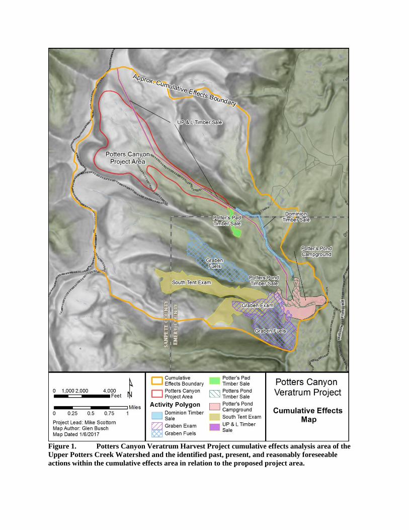
Figure 1. Potters Canyon Veratrum Harvest Project cumulative effects analysis area of the
Upper Potters Creek Watershed and the identified past, present, and reasonably foreseeable
actions within the cumulative effects area in relation to the proposed project area.

Table 1. Past, present, and reasonably foreseeable actions identified within the cumulative
effects analysis area for the proposed Potters Canyon Veratrum Harvest Project.
ACTION STATUS SIZE (ACRES)
UP&L Timber Sale1 Accomplished 67.0
Dominion Timber Sale1 Accomplished 28.4
Potters Pond Timber Sale1 Accomplished 30.1
Potters Pad Timber Sale1 Accomplished 14.1
Potters Pond Campground1 Current 113.7
Graben Fuels1 Accomplished 355.2
South Tent Exam1 Planning 282.4
Total Disturbance1 890.9
Potters Canyon S&G Grazing
Allotment2
Current:
July-September Annually
(900 Ewes/Lambs)
Entire Effects
Area
Upper Potters Canyon Cumulative Effects Area Total Size 5,245.8
1Information derived from the Manit-LaSal Forest GIS Data Clearinghouse. Accessed data layer is the Activity
Polygon, which is described as “depicts the area of activities recorded in the Forest Service Activity Tracking
System (FACTS).” Date of access 12/01/2016.
2Annual Operating Instruction (AOI) for the Potters, Booths Canyon and Fly Bulger S&G Allotments for 2016.
Ferron/Price Ranger District, May 18, 2016.