Embed Size (px)
Citation preview
USDA Forest Service Tahoe National Forest, Yuba River Ranger District
BIOLOGICAL ASSESSMENT / BIOLOGICAL EVALUATION OF BOTANICAL SPECIES
Yuba Project
08/01/2017 Prepared by: _________________________________ Date: ________________ Courtney Rowe, District Botanist
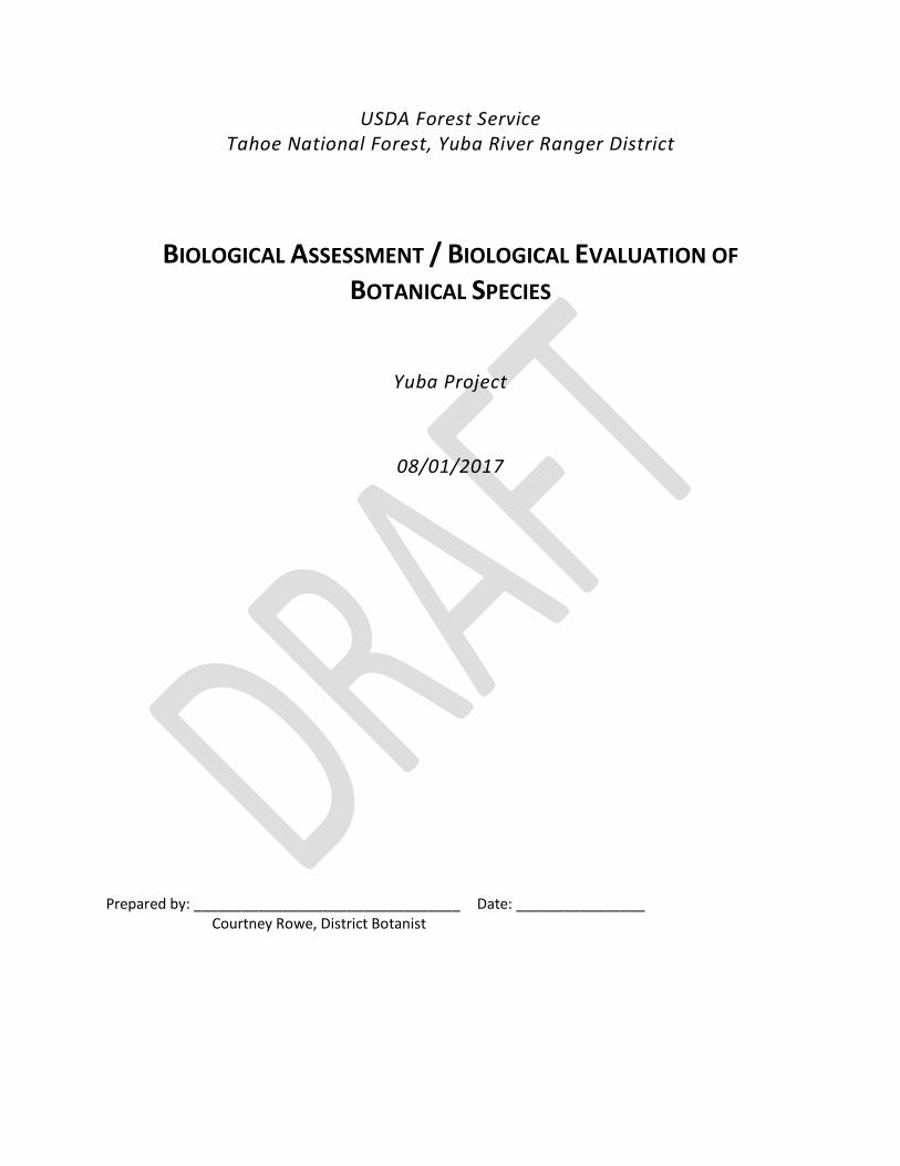
Summary of Determinations For federally threatened and endangered and Forest Service (TES)
botanical species with known occurrences or suitable habitat in analysis area Species Common name Alternative A
Determination Alternative B Determination
Alternative C Determination
Rationale
Lewisia kelloggii ssp. hutchinsonii
Hutchinson’s lewisia
MANL WN MANL There are no known occurrence that intersects proposed activities, but unsurveyed habitat in underburn units; there is low potential for short-term & long-term negative impacts to suitable habitat; the included management requirements are sufficient to protect
occurrences and maintain suitable habitat. Lewisia kelloggii ssp.
kelloggii Kellogg’s
lewisia MANL WN MANL Same as above
Botrychium ascendens upswept
moonwort WN WN WN My determination is based on the lack of occurrences and the
negligible impacts to suitable habitat within the project area. Botrychium crenulatum scalloped
moonwort WN WN WN Same as above
Botrychium lunaria common moonwort
WN WN WN Same as above
Botrychium montanum western goblin WN WN WN Same as above Bruchia bolanderi Bolander’s
bruchia WN WN WN Same as above
Eriogonum umbellatum var. torreyanum
Donner Pass buckwheat
WN WN WN Same as above
Meesia uliginosa broad-nerved hump-moss
WN WN WN Same as above
Peltigera gowardii Goward’s waterfan
WN WN WN Same as above
Penstemon personatus closed-throated beardtongue
WN WN WN Same as above
Pinus albicaulis whitebark pine WN WN WN Same as above Poa sierrae Sierra
bluegrass WN WN WN Same as above
Tauschia howellii Howell’s tauschia
WN WN WN Same as above
Cudonia monticola Large cudonia MANL WN MANL Lack of known occurrences in the project area; there is the
potential for short-term negative impacts to suitable habitat; the included management requirements are sufficient to maintain or
improve suitable habitat Dendrocollybia
racemosa branched collybia
MANL WN MANL Same as above
Phaeocollybia olivacea olive phaeocollybia
MANL WN MANL Same as above
Sowerbyella rhenana stalked orange peel-fungus
MANL WN MANL Same as above
MANL— may affect individuals but is not likely to result in a trend toward federal listing; WN—will not affect TES species outside of the analysis area are not anticipated to be impacted by the proposed project either directly, indirectly, or cumulatively
TABLE OF CONTENTS 1 Introduction ........................................................................................................................................ 1
2 Current Management Direction .......................................................................................................... 1
3 Description of the Project ................................................................................................................... 1
4 Effects Analysis Methodology ............................................................................................................. 3
4.1 Analysis Methodology ................................................................................................................. 3
4.2 Geographic Area ......................................................................................................................... 5
4.3 Data Sources ............................................................................................................................... 5
4.4 Type and Duration Of Effects ...................................................................................................... 5
4.5 Species Considered ..................................................................................................................... 6
5 Effects of the Project........................................................................................................................... 9
5.1 General effects to TES botanical species ..................................................................................... 9
5.2 Lewisia kelloggii spp. hutchinsonii & spp. kelloggii (Hutchinson & Kellogg’s lewisias) .............. 14
5.3 Species with suitable habitat, but no occurrences in project area ............................................ 15
5.4 Other Botanical Resources ........................................................................................................ 18
6 Compliance with Current Management Direction ............................................................................ 18
7 References ........................................................................................................................................ 18
Appendix A. Maps ....................................................................................................................................... 1
Appendix B. Botanical Resource Protection Plan ........................................................................................ 1
LIST OF TABLES
Table 1. Proposed treatments (differences between alternative in bold) ................................................................... 2 Table 2. Units where prescriptions differ between Alternative A and Alternative C ................................................... 2 Table 3. Proposed road and trail treatments ............................................................................................................. 2 Table 4. Current surveys in the project area .............................................................................................................. 4 Table 5. List of TES botanical species considered for Yuba Project ............................................................................. 7 Table 6. Summary of habitat types in the project area ............................................................................................ 10 Table 7. Species with suitable habitat, but no known occurrences in the project area ............................................. 16
Botanical Species BA/BE—Yuba Project
Page 1 of 19
1 INTRODUCTION The purpose of this document is to analyze the activities proposed under the Yuba Project and to determine whether they have the potential to affect any federally threatened and endangered and Forest Service Sensitive plant, lichen, and fungi species and their habitats (referred to collectively as TES botanical species). The Yuba Project is proposed by the Yuba River Ranger District to enhance watershed health through improving forest health and resilience to changing climatic conditions, reducing surface and ladder fuels to a level that would allow safe fire suppression, and improving wildlife habitat. The approximately 14,500 acre project area encompasses National Forest system (NFS) lands, located east and northeast of the community of Sierra City, north and northeast of Bassets, and west of Yuba Pass (T20N, R12E Sections 1,2,3,10,11,12; T21N R12E Sections 13,14,15,22 thru 28,34,35,36; T20N R13E Sections 2 thru 6,8,9,10; and T21N R13E Sections 19,20,21,27 thru 35), all within Sierra County. The project involves three alternatives and is described in detail in the Yuba Project Environmental Assessment.
2 CURRENT MANAGEMENT DIRECTION Current management direction regarding TES (federal threatened and endangered, Forest Service Sensitive) species management on the TNF can be found in the following documents, filed at the District Office: Endangered Species Act (ESA); National Environmental Policy Act (NEPA); National Forest Management Act (NFMA); Tahoe National Forest Land and Resource Management Plan (1988) as amended by the Sierra Nevada Forest Plan Amendment (2004); Forest Service Manual (FSM 2670); -Pacific Southwest Region (R5) policy and management direction; species management plans, guides or conservation strategies In general, federal law and Forest Service policy and direction directs the TNF to ensure that Forest Service actions do not jeopardize or adversely modify critical habitat of Federally listed species; do not result in a trend toward federal listing of any FSS species; do not contribute to loss of viability of any native plant species; and provides a process and standard through which rare plant species receive full consideration throughout the planning process, reducing negative impacts on species and enhancing opportunities for mitigation.
3 DESCRIPTION OF THE PROJECT The project is described in detail in the Yuba Project Environmental Assessment. There are two action and one no-action alternatives: Alternative A—proposed action; alternative B—no action; and Alternative C—wildlife focus. The proposed action includes the following activities: mechanical thinning; planting native conifers in a portion of the gaps; aspen restoration (conifer removal both by hand and/or mechanical equipment); pre-commercial thinning; manual, mechanical and smothering treatments of non-native invasive plants; roadside and power distribution line hazard tree removal; borate compound application to freshly cut stumps; hand cutting, hand piling, and pile burning; under burning; helitorch prescribed fire for wildlife habitat (shrubfield) enhancement; road decommissioning; road recondition/reconstruction and maintenance; replace/restore a non-functioning waterhole with a functioning one; meadow habitat enhancement (conifer removal both by hand and/or mechanical equipment); installation of nest boxes and creation of wildlife cover piles; trail construction between the
Botanical Species BA/BE—Yuba Project
Page 2 of 19
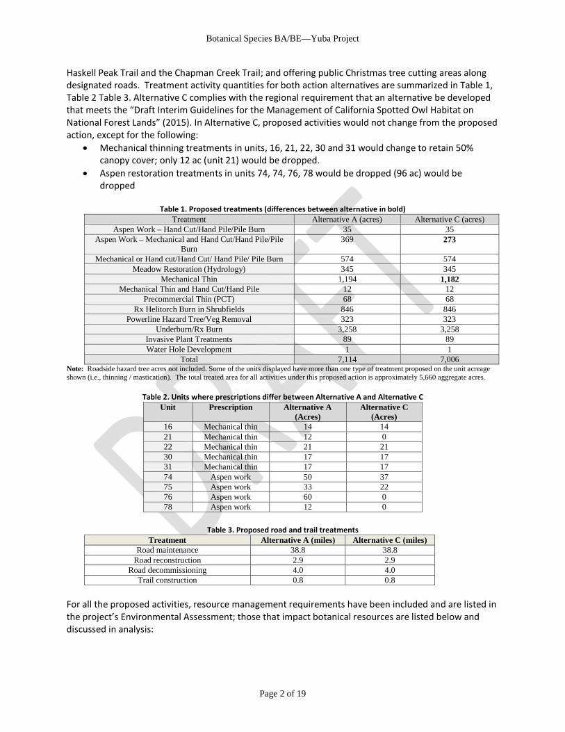
Haskell Peak Trail and the Chapman Creek Trail; and offering public Christmas tree cutting areas along designated roads. Treatment activity quantities for both action alternatives are summarized in Table 1, Table 2 Table 3. Alternative C complies with the regional requirement that an alternative be developed that meets the “Draft Interim Guidelines for the Management of California Spotted Owl Habitat on National Forest Lands” (2015). In Alternative C, proposed activities would not change from the proposed action, except for the following:
• Mechanical thinning treatments in units, 16, 21, 22, 30 and 31 would change to retain 50% canopy cover; only 12 ac (unit 21) would be dropped.
• Aspen restoration treatments in units 74, 74, 76, 78 would be dropped (96 ac) would be dropped
Table 1. Proposed treatments (differences between alternative in bold) Treatment Alternative A (acres) Alternative C (acres)
Aspen Work – Hand Cut/Hand Pile/Pile Burn 35 35 Aspen Work – Mechanical and Hand Cut/Hand Pile/Pile
Burn 369 273
Mechanical or Hand cut/Hand Cut/ Hand Pile/ Pile Burn 574 574 Meadow Restoration (Hydrology) 345 345
Mechanical Thin 1,194 1,182 Mechanical Thin and Hand Cut/Hand Pile 12 12
Precommercial Thin (PCT) 68 68 Rx Helitorch Burn in Shrubfields 846 846
Powerline Hazard Tree/Veg Removal 323 323 Underburn/Rx Burn 3,258 3,258
Invasive Plant Treatments 89 89 Water Hole Development 1 1
Total 7,114 7,006 Note: Roadside hazard tree acres not included. Some of the units displayed have more than one type of treatment proposed on the unit acreage shown (i.e., thinning / mastication). The total treated area for all activities under this proposed action is approximately 5,660 aggregate acres.
Table 2. Units where prescriptions differ between Alternative A and Alternative C
Unit Prescription Alternative A (Acres)
Alternative C (Acres)
16 Mechanical thin 14 14 21 Mechanical thin 12 0 22 Mechanical thin 21 21 30 Mechanical thin 17 17 31 Mechanical thin 17 17 74 Aspen work 50 37 75 Aspen work 33 22 76 Aspen work 60 0 78 Aspen work 12 0
Table 3. Proposed road and trail treatments
Treatment Alternative A (miles) Alternative C (miles) Road maintenance 38.8 38.8
Road reconstruction 2.9 2.9 Road decommissioning 4.0 4.0
Trail construction 0.8 0.8 For all the proposed activities, resource management requirements have been included and are listed in the project’s Environmental Assessment; those that impact botanical resources are listed below and discussed in analysis:
Botanical Species BA/BE—Yuba Project
Page 3 of 19
• MMR-BOT1: Special status botanical occurrences (T&E, FSS, TNF Watch list) will be flagged and avoided for all ground disturbing activities with a buffer of 100 feet (Units 07, 14, 20, 23, 34, 58, 82, 102, 103, 104, 106, D). Trees will be felled away from known occurrences. All TES botanical species occurrences will be flagged prior to implementation and indicated on project maps.
• MMR-BOT2: Proposed road construction, reconstruction, landings and staging areas in potential habitat for TES botanical species will be designed and marked on the ground only after the areas have been surveyed by a qualified botanist in the proper season.
• MMR-BOT3: Surveys will be completed for Lewisia kelloggii prior to project implementation and all newly discovered populations will be flagged and avoided. (All suitable habitat in mechanical & hand-thin units have now been surveyed as of August 2017, so this MMR has been removed)
• MMR-BOT4: No ground disturbance will occur in peat-dominated soils, unless critical to restoring hydrologic function (Unit 101-107).
• MMR-BOT5: Burn piles will not be placed in known special status botanical occurrences. Fireline will be placed at least 100ft from known occurrences. Under burn is allowed in occurrences when special status species are dormant, except for Lewisia kelloggii. No ground-based prescribed burn activities will occur in Lewisia kelloggii habitat (A, C, D, G). No ground based prescribed burn activities will occur in Unit B 1.
• MMR-IP1: All equipment and vehicles (Forest Service and contracted) used for project implementation must be free of invasive plant material before moving into the project area. Equipment will be considered clean when visual inspection does not reveal soil, seeds, plant material or other such debris. Cleaning shall occur at a vehicle washing station or steam-cleaning facility before the equipment and vehicles enter the project area. Equipment used during emergency work or used exclusively on paved surfaces is exempt from the cleaning requirement. When working in known invasive plant infestations, equipment shall be cleaned before moving to other National Forest Service system lands. Avoidance areas will be identified on project maps.
• MMR-IP2: All gravel, fill, top soil or other materials are required to be weed-free. When possible, use onsite sand, gravel, rock, top soil or organic matter when possible, unless infested with invasive species; do not use material (or soil) from areas contaminated by invasive species. Obtain materials from sources that have been certified as weed-free.
• MMR-IP3: Avoid disturbance and do not locate landings or stage equipment in known invasive plant infestations. • MMR-IP4: Invasive plant infestations will be avoided during equipment traffic and soil-disturbing project activities.
Avoidance areas will be flagged prior to implementation and identified on project maps. • MMR-IP5: As needed, revegetate landings/staging areas/parking areas/other openings created during project
implementation. Seed and plant mixes must be approved the District Botanist or their designated appointee who has knowledge of local flora. Invasive species and persistent non-native species will not be intentionally used in revegetation. Native plant and seed material should be collected from as close to the project area as possible, from within the same watershed, and at a similar elevation whenever possible.
• MMR-IP6: No project activities will be conducted within 100 feet of cheat grass infestation along Forest Road 9-5 until treatment has been conducted.
4 EFFECTS ANALYSIS METHODOLOGY 4.1 ANALYSIS METHODOLOGY The Forest Service prescribes a three-step process for analysis the effects to TES species which was followed for this project: pre-field review, followed by field reconnaissance, then conflict determination (FSM 2672.43; USDA Forest Service 2005). For pre-field review, all TES species that were known or were believed to have potential to occur in the analysis area were identified. Species occurrence information was compiled using the forest service’s database of record—the Natural Resource Information System (NRIS), California Natural Diversity Database (CNDDB) records, TNF rare botanical species records, and past survey reports. Estimates of suitable habitat were produced using the following TNF corporate spatial datasets: meadows (USDA Forest Service 2015a), National Hydrography Dataset (NHD) flowlines and areas (USDA Forest Service 2015b), Existing Vegetation (USDA Forest Service 2009) and National Agricultural Imagery Program (NAIP) imagery (USDA Farm Service Agency 2014). Existing vegetation was classified using the CDFW’s California Wildlife Habitat Relationship (CHWR) type because the classification takes into account both species composition and stand structure and is considered a standard vegetation
Botanical Species BA/BE—Yuba Project
Page 4 of 19
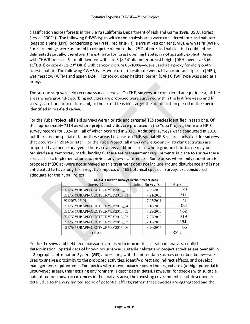
classification across forests in the Sierra (California Department of Fish and Game 1988; USDA Forest Service 2004a). The following CHWR types within the analysis area were considered forested habitat: lodgepole pine (LPN), ponderosa pine (PPN), red fir (RFR), sierra mixed conifer (SMC), & white fir (WFR). Forest openings were assumed to comprise no more than 25% of forested habitat, but could not be delineated spatially; therefore, the estimate for forest opening habitat is not spatially explicit. Areas with CHWR tree size 6—multi-layered with size 5 (> 24” diameter breast height (DBH) over size 3 (6-11”DBH) or size 4 (11-23” DBH) with canopy closure 60-100%—were used as a proxy for old growth forest habitat. The following CWHR types were used to estimate wet habitat: montane riparian (MRI), wet meadow (WTM) and aspen (ASP). For rocky, open habitat, barren (BAR) CHWR type was used as a proxy. The second step was field reconnaissance surveys. On TNF, surveys are considered adequate if: a) all the areas where ground-disturbing activities are proposed were surveyed within the last five years and b) surveys are floristic in nature and, to the extent feasible, target the identification period of the species identified in pre-field review. For the Yuba Project, all field surveys were floristic and targeted TES species identified in step one. Of the approximately 7114 ac where project activities are proposed in the Yuba Project, there are NRIS survey records for 3324 ac—all of which occurred in 2015. Additional surveys were conducted in 2010, but there are no spatial data for these areas because, on TNF, spatial NRIS records only exist for surveys that occurred in 2014 or later. For the Yuba Project, all areas where ground-disturbing activities are proposed have been surveyed. There are a few additional areas where ground disturbance may be required (e.g. temporary roads, landings); there are management requirements in place to survey these areas prior to implementation and protect any new occurrences. Some areas where only underburn is proposed (~890 ac) were not surveyed as this treatment does not include ground disturbance and is not anticipated to have long-term negative impacts on TES botanical species. Surveys are considered adequate for the Yuba Project.
Table 4. Current surveys in the project area Survey ID Units Survey Date Acres
051753YUBAPROJECTSURVEY2015_07 7/20/2015 89 051753YUBAPROJECTSURVEY2015_01 7/21/2015 311 39120F5-16-01 7/25/2016 41 051753YUBAPROJECTSURVEY2015_04 8/18/2015 434 051753YUBAPROJECTSURVEY2015_05 7/29/2015 982 051753YUBAPROJECTSURVEY2015_03 7/27/2015 219 051753YUBAPROJECTSURVEY2015_02 7/12/2015 1,184 051753YUBAPROJECTSURVEY2015_06 8/26/2015 65
TOTAL 3324 Pre-field review and field reconnaissance are used to inform the last step of analysis: conflict determination. Spatial data of known occurrences, suitable habitat and project activities are overlaid in a Geographic Information System (GIS) and—along with the other data sources described below—are used to analyze proximity to the proposed activities, identify direct and indirect effects, and develop management requirements. For species with known occurrences in the project area (or high potential in unsurveyed areas), their existing environment is described in detail. However, for species with suitable habitat but no known occurrences in the analysis area, their existing environment is not described in detail, due to the very limited scope of potential effects; rather, these species are aggregated and the

Botanical Species BA/BE—Yuba Project
Page 5 of 19
indirect effects to these habitat types are discussed. Conflict determinations are provided for all species known to occur or have suitable habitat impacted by proposed activities.
4.2 GEOGRAPHIC AREA The area analyzed in this document encompasses approximately 29,000 ac and consists of all proposed activities, access roads to the project area, and an area approximately one mile around all proposed activities (Appendix A). This one-mile buffer was selected to capture all potential rare botanical species that (a) occur within the project area, (b) have suitable habitat within the project area, or (c) are near enough to potentially be affected indirectly by project activities.
4.3 DATA SOURCES Basic information describing the life history, ecology, pollination biology, and specific habitat requirements is lacking for many rare botanical species. Scientific literature and internal government documents (i.e. species-specific conservation assessments) were utilized for the analysis whenever available; however more frequently the analysis of effects was based on observations by qualified individuals, field experience, unpublished monitoring results, and studies of comparable species.
4.4 TYPE AND DURATION OF EFFECTS
4.4.1 Direct Effects Direct effects occur when individual plants, lichen, or fungi are physically impacted. Examples of proposed activities that have the potential to directly affect botanical species include ground disturbance activities, scorching or burning during prescribed burns. These actions can result in death, altered growth, or reduced seed set through physically breaking, crushing, burning, scorching, or uprooting botanical species.
4.4.2 Indirect Effects Indirect effects are separated from an action in either time or space. These effects—which can be beneficial or detrimental to TES species—most commonly involve alteration of habitat, but may also include changes to seed bank or genetic resources. Important factors in analyzing indirect effects for the Yuba project include changes in vegetation composition, successional patterns, fire regimes, and the distribution and abundance of invasive plants.
4.4.3 Cumulative Effects A cumulative effect can result from the incremental effect of the current action when added to the effects of past, present, and reasonably foreseeable future actions. These effects are considered regardless of what agency or person undertakes the other actions and regardless of land ownership on which the other actions occur. An individual action when considered alone may not have a significant effect, but when its effects are considered in sum with the effects of other past, present, and reasonably foreseeable future actions, the effects may be significant (40 CFR 1508.7-8; FSH 1909.15). In accordance with CEQ guidance, this analysis uses the current condition of TES botanical species (i.e. abundance and distribution as well as trend and habitat condition, when known) as a proxy for the impacts of past actions.
Botanical Species BA/BE—Yuba Project
Page 6 of 19
4.4.4 Duration of Effects It is difficult to state with certainty when the effects of the proposed activities will no longer alter the life history dynamics or habitat of the TES botanical species considered in this analysis. The following assumptions were employed to assess duration of effects:
1) Short-term effects to TES botanical species are those lasting less than 10 years; beyond 10 years, effects are considered long-term, except when specified as permanent.
2) For harvest, mechanical thinning and temporary road / landing construction, recovery time of the vegetation to current condition is approximately 50 years. For hand thinning and under burning, recovery time of the vegetation to current condition is approximately 20 years.
3) Trail construction, soil decompaction and road decommissioning are considered permanent. 4) Installation of nest boxes and offering public Christmas tree cutting areas are not anticipated to
have short or long term impact TES botanical species
4.5 SPECIES CONSIDERED
4.5.1 Species considered under the Endangered Species Act All federally threatened or endangered botanical species that are known or have suitable habitat on TNF were considered. The U.S. Fish and Wildlife Service (USFWS) is contacted every 90 days to obtain a current list of threatened, endangered, proposed and candidate species that may be present on the Tahoe National Forest (TNF). The most recent list was dated 02/13/2017 and stored digitally on the TNF’s web-based server. There are two federally threatened botanical species known to occur or with known suitable habitat on TNF: Ivesia webberi (Webber’s ivesia) and Packera layneae (Layne’s butterweed). There is one candidate species known to occur on TNF—Pinus albicaulis (whitebark pine); it is also designated as Forest Service Sensitive and discussed with the other FSS species in this analysis. Layne’s butterweed is limited to Butte, Yuba, Placer, Eldorado and Tuolumne Counties; Sierra County is entirely outside the species range, as well as substantially higher in elevation. Webber’s ivesia known in Sierra County, but it is restricted to the east side of the Sierra crest, so the project area is outside of the species range. There are three additional species that appear on the UWFWS list for TNF, but none of these have occurrences or suitable habitat are known on TNF: slender orcutt grass (Orcuttia tenuis) which is limited to vernal pools in the NE Sacramento Valley and far north California (Plumas, Lassen, Shasta & Siskiyou counties); Pine Hill flannelbush (Fremontodendron decumbens) which is known only on ultramafic soils below 2500ft in Eldorado and (possibly) Nevada Counties; and Stebbins morning glory (Calystegia stebbinsii) which is known only on ultramafic soils below 2500ft in Eldorado and Nevada Counties. Because the range of these five species are wholly outside the analysis area, none of species will be affected by the project and are not discussed further. This review constitutes the project’s Biological Assessment.
4.5.2 R5 Regional Forester’s Sensitive Species List The Regional Forester identifies species for which population viability is a concern because of (1) downward population trends and/or (2) diminished habitat capacity that would reduce species distribution (FSM 2672.11, USDA 2005). The R5 Sensitive list was last revised in 2013 (USDA Forest
Botanical Species BA/BE—Yuba Project
Page 7 of 19
Service 2013). All Forest Service Region 5 Sensitive botanical species that are known or have suitable habitat on TNF were considered.
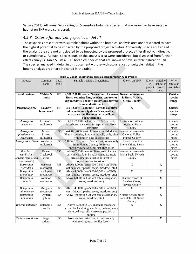
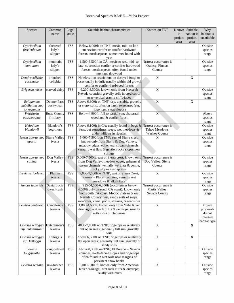
4.5.3 Criteria for analyzing species in detail Those species present or with suitable habitat within the botanical analysis area are anticipated to have the highest potential to be impacted by the proposed project activities. Conversely, species outside of the analysis area are not anticipated to be impacted by the proposed project either directly, indirectly, or cumulatively. As such, species outside the analysis area were considered, but dismissed from further effects analysis. Table 5 lists all TES botanical species that are known or have suitable habitat on TNF. The species analyzed in detail in this document—those with occurrences or suitable habitat in the botany analysis area—are indicated in the table.
Table 5. List of TES botanical species considered for Yuba Project Species Common
name Legal status
Suitable habitat characteristics Known on TNF Known in
project area
Suitable habitat in project
area
Why habitat is unsuitable
Ivesia webberi Webber’s ivesia
FT 4,500-7,500ft; east of Sierra crest; Lassen – Sierra counties; flats, benches, terraces or dry meadows; shallow, clayey soils derived
from andesitic rock
Nearest occurrence is Sierra Valley, Sierra County
Outside species range
Packera layneae Layne’s butterweed
FT 650-3,600ft; Tuolumne - Nevada counties; ultramafic soils (gabbro & serpentine); chaparral, conifer forest or woodland
edges/openings
X Outside species range
Astragalus lemmonii
Lemmon’s milkvetch
FSS 4,000-7,000ft in CA; east of Sierra crest; lakeshores, meadows & seeps among Great
Basin scrub
Historic record near Loyalton, Sierra
County
Outside species range
Astragalus pulsiferae var.
coronensis
Modoc Plateau
milkvetch
FSS 4,400-6,200ft; east of Sierra crest; Modoc – Plumas counties; Sandy or gravelly soils, often
with juniper, pine or sagebrush
Nearest occurrence is Genesee Valley, Plumas County
Outside species range
Astragalus webberi Webber’s milkvetch
FSS 2,400-4,100ft; east of Sierra crest; known only from Plumas County; dry forest
openings/edges & semi-disturbed areas
Historic record in Sierra Valley, Sierra
County
Outside species range
Boechera rigidissima
(Arabis rigidissima var. demota)
Galena Creek rock
cress
FSS Above 7,500ft; east of Sierra crest; known only in Nevada & Douglas counties; mesic
areas (sometimes rocky) at forest to aspen/meadow transitions
Nearest occurrence is Martis Peak, Nevada
County
Outside species range
Botrychium ascendens
upswept moonwort
FSS Above 4,000ft (gen 5,000-7,500ft on TNF); wet habitats (riparian, seeps, meadows, etc.)
X X
Botrychium crenulatum
scalloped moonwort
FSS Above 4,000ft (gen 5,000-7,500ft on TNF); wet habitats (riparian, seeps, meadows, etc.)
X X
Botrychium lunaria
common moonwort
FSS Above 6,000ft in CA; wet habitats (riparian, seeps, meadows, etc.)
Historic record at Sagehen Creek, Nevada County
X
Botrychium minganense
Mingan’s moonwort
FSS Above 4,000ft (gen 5,000-7,500ft on TNF); wet habitats (riparian, seeps, meadows, etc.)
X X
Botrychium montanum
western goblin
FSS Above 4,000ft in CA; wet habitats (riparian, seeps, meadows, etc.)
Nearest occurrence is Randolph Hill, Sierra
County
X
Bruchia bolanderi Bolander’s bruchia
FSS Above 5,000ft in CA; montane meadows, stream banks, drying lake beds; on bare, semi-
disturbed wet soils where competition is minimal
X X
Cudonia monticola large cudonia
FSS No elevation restriction; in duff; usually within old-growth conifer forests
X X
Botanical Species BA/BE—Yuba Project
Page 8 of 19
Species Common name
Legal status
Suitable habitat characteristics Known on TNF Known in
project area
Suitable habitat in project
area
Why habitat is unsuitable
Cypripedium fasciculatum
clustered lady’s slipper
FSS Below 6,000ft on TNF; mesic, mid- to late- succession conifer or conifer-hardwood
forests; north aspects; sometimes found with yew
X Outside species range
Cypripedium montanum
mountain lady’s slipper
FSS 1,500-6,500ft in CA; mesic to wet, mid- to late- succession conifer or conifer-hardwood
forests; north aspects; often found under montane dogwood
Nearest occurrence is Quincy, Plumas
County
Outside species range
Dendrocollybia racemosa
branched collybia
FSS No elevation restriction; on decayed fungi or occasionally in duff; usually within old growth
conifer or conifer-hardwood forests
X X
Erigeron miser starved daisy FSS 6,200-8,500ft; known only from Placer & Nevada counties; gravelly soils in crevices of
near-vertical granite cliffs/faces
X Outside species range
Eriogonum umbellatum var.
torreyanum
Donner Pass buckwheat
FSS Above 6,800ft on TNF; dry, unstable, gravelly or stony soils; often on harsh exposures (e.g.
ridge tops, steep slopes)
X X
Fritillaria eastwoodiae
Butte County frittilary
FSS Below 4,900ft; full to partial sun; chaparral, woodland & conifer forest
X Above species range
Helodium blandowii
Blandow’s bog-moss
FSS Above 6,100ft in CA; usually found in bogs & fens, but sometimes seeps, wet meadows &
under willows in riparian
Nearest occurrence is Tahoe Meadows, Washoe County
Outside species range
Ivesia aperta var. aperta
Sierra Valley ivesia
FSS 5,000-7,500ft on TNF; east of Sierra crest; known only from Sierra & Dog Valleys;
meadow edges, ephemeral stream channels, vernally wet flats & gentle, rocky slopes near
springs
X Outside species range
Ivesia aperta var. canina
Dog Valley ivesia
FSS 5,000-7,500ft; east of Sierra crest; known only from Dog Valley; meadow edges, ephemeral stream channels, vernally wet flats & gentle,
rocky slopes near springs
Nearest occurrence is Dog Valley, Sierra
County
Outside species range
Ivesia sericoleuca Plumas ivesia
FSS 5,000-7,500ft on TNF; east of Sierra Crest; Plumas – Placer counties; vernally wet
meadows & alkali flats
X Outside species range
Juncus luciensis Santa Lucia dwarf-rush
FSS (925-)4,500-6,300ft (occurrences below 4,500ft only on south CA coast); known only from south CA coast, Modoc Plateau & east Nevada County; wet, sandy soils of seeps,
meadows, vernal pools, streams, & roadsides
Nearest occurrence is Martis Valley, Nevada County
Outside species range
Lewisia cantelovii Cantelow’s lewisia
FSS 1,000-4,500ft; known only from Yuba River drainage; wet rock cliffs & outcrops; usually
with moss or club moss
X Project proposals
do not intersect
habitat type Lewisia kelloggii ssp. hutchinsonii
Hutchinson’s lewisia
FSS 4800-7,000ft on TNF; ridgetops or relatively flat open areas; generally full sun; gravelly
soils
X X
Lewisia kelloggii ssp. kelloggii
Kellogg’s lewisia
FSS Above 6,500ft on TNF; ridgetops or relatively flat open areas; generally full sun; gravelly or
sandy soils
X X
Lewisia longipetala
long-petaled lewisia
FSS Above 8,300ft on TNF; El Dorado – Nevada counties; north-facing slopes and ridge tops
often found in wet soils near margins of persistent snow banks
X Outside species range
Lewisia serrata saw-toothed lewisia
FSS 3,000-5,000ft; known only from American River drainage; wet rock cliffs & outcrops;
usually with moss
X Outside species range
Botanical Species BA/BE—Yuba Project
Page 9 of 19
Species Common name
Legal status
Suitable habitat characteristics Known on TNF Known in
project area
Suitable habitat in project
area
Why habitat is unsuitable
Meesia uliginosa broad-nerved hump-moss
FSS Above 6,000ft on TNF; usually found in bogs or fens, but also very wet meadows
X X
Mielichhoferia elongata
elongate copper-moss
FSS Below 3,500ft; soils with copper or heavy metals; moist to wet rock cliffs/outcrops
Nearest occurrence is Shady Creek, Nevada
County
Outside species range
Monardella follettii
Follett’s monardella
FSS 2,500-5,600ft; known only from Plumas County; serpentine soils; partial to full sun;
conifer forest edges/openings
Nearest occurrence is Meadow Valley, Plumas County
Outside species range
Peltigera gowardii Goward’s waterfan
FSS 1,150-7,000ft in CA; cold, clear, unpolluted streams; often found on rocks in cascades
Nearest occurrence is Bushy Creek, Yuba
County
X
Penstemon personatus
closed-throated
beardtongue
FSS 4,500-6,500ft; Plumas – north Nevada County; partial sun; north aspects; conifer forest
edges/openings
X X
Phacelia stebbinsii Stebbins phacelia
FSS 2,000-6,700ft; known only in Rubicon & American River drainages partial to full sun;
generally in rocky openings/outcrops, but also woodland or conifer forest edges/openings
X Outside species range
Phaeocollybia olivacea
olive phaeocollybi
a
FSS No elevation restriction; Yuba County & north; on roots of Pinaceae & Fagaceae;
usually within old growth conifer or conifer-hardwood forests
X X
Pinus albicaulis whitebark pine
FSS, C Above 6,500ft on TNF; subalpine & at timberline on rocky, well-drained soils
X X
Poa sierrae Sierra bluegrass
FSS 1,000-5,500ft; shady moist slopes; conifer forest edges/openings
X X
Pyrrocoma lucida sticky pyrrocoma
FSS 4,500-6,000ft on TNF; east of Sierra crest; known only from Plumas & Sierra Counties;
vernally wet meadows & alkali flats
X Outside species range
Sowerbyella rhenana
stalked orange peel-
fungus
FSS No elevation restriction; in duff; wet mossy areas; usually within old growth conifer
forests
X X
Tauschia howellii Howell’s tauschia
FSS 5,500-8,500ft in CA; xeric ridge summits & slopes; decomposed granite gravel or sand; red
fir & subalpine forest edges/openings
X X
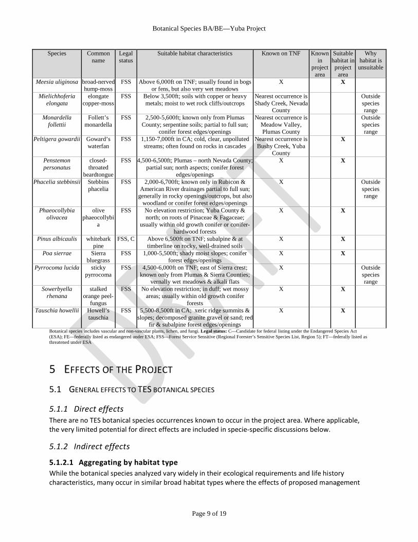
Botanical species includes vascular and non-vascular plants, lichen, and fungi. Legal status: C—Candidate for federal listing under the Endangered Species Act (ESA); FE—federally listed as endangered under ESA; FSS—Forest Service Sensitive (Regional Forester’s Sensitive Species List, Region 5); FT—federally listed as threatened under ESA
5 EFFECTS OF THE PROJECT 5.1 GENERAL EFFECTS TO TES BOTANICAL SPECIES
5.1.1 Direct effects There are no TES botanical species occurrences known to occur in the project area. Where applicable, the very limited potential for direct effects are included in specie-specific discussions below.
5.1.2 Indirect effects
5.1.2.1 Aggregating by habitat type While the botanical species analyzed vary widely in their ecological requirements and life history characteristics, many occur in similar broad habitat types where the effects of proposed management
Botanical Species BA/BE—Yuba Project
Page 10 of 19
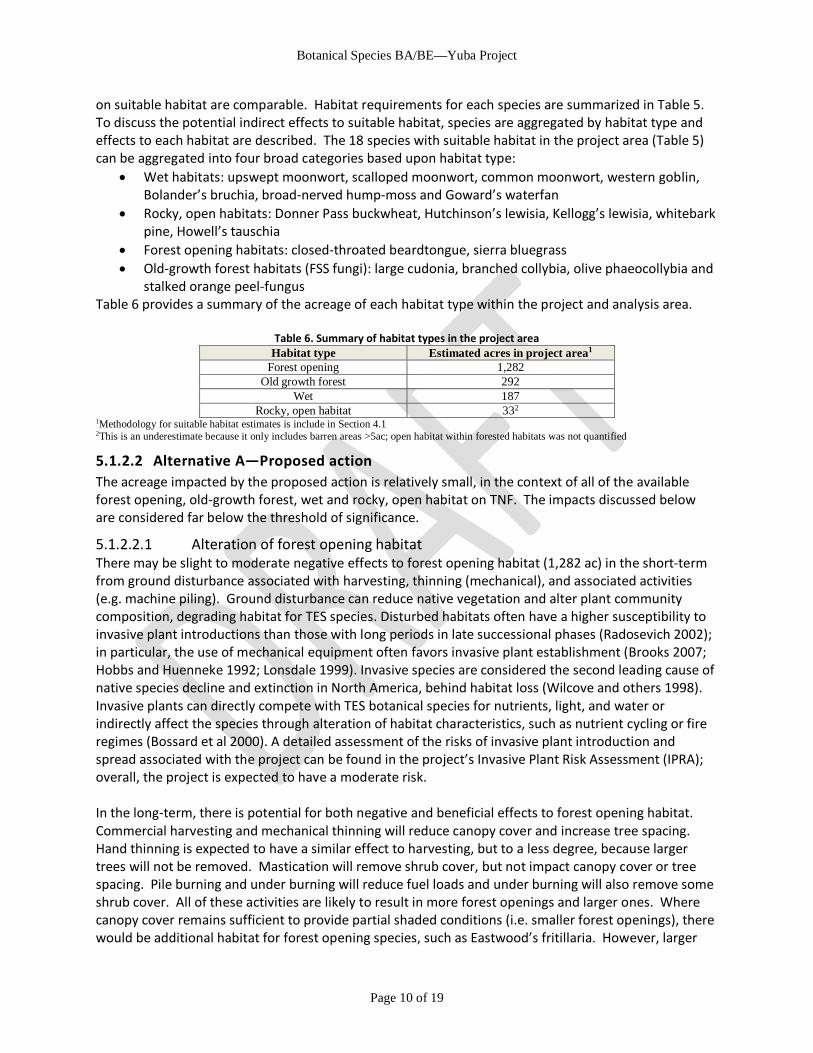
on suitable habitat are comparable. Habitat requirements for each species are summarized in Table 5. To discuss the potential indirect effects to suitable habitat, species are aggregated by habitat type and effects to each habitat are described. The 18 species with suitable habitat in the project area (Table 5)
can be aggregated into four broad categories based upon habitat type: • Wet habitats: upswept moonwort, scalloped moonwort, common moonwort, western goblin,
Bolander’s bruchia, broad-nerved hump-moss and Goward’s waterfan • Rocky, open habitats: Donner Pass buckwheat, Hutchinson’s lewisia, Kellogg’s lewisia, whitebark
pine, Howell’s tauschia • Forest opening habitats: closed-throated beardtongue, sierra bluegrass • Old-growth forest habitats (FSS fungi): large cudonia, branched collybia, olive phaeocollybia and
stalked orange peel-fungus Table 6 provides a summary of the acreage of each habitat type within the project and analysis area.
Table 6. Summary of habitat types in the project area Habitat type Estimated acres in project area1
Forest opening 1,282 Old growth forest 292
Wet 187 Rocky, open habitat 332
1Methodology for suitable habitat estimates is include in Section 4.1 2This is an underestimate because it only includes barren areas >5ac; open habitat within forested habitats was not quantified
5.1.2.2 Alternative A—Proposed action The acreage impacted by the proposed action is relatively small, in the context of all of the available forest opening, old-growth forest, wet and rocky, open habitat on TNF. The impacts discussed below are considered far below the threshold of significance.
5.1.2.2.1 Alteration of forest opening habitat There may be slight to moderate negative effects to forest opening habitat (1,282 ac) in the short-term from ground disturbance associated with harvesting, thinning (mechanical), and associated activities (e.g. machine piling). Ground disturbance can reduce native vegetation and alter plant community composition, degrading habitat for TES species. Disturbed habitats often have a higher susceptibility to invasive plant introductions than those with long periods in late successional phases (Radosevich 2002); in particular, the use of mechanical equipment often favors invasive plant establishment (Brooks 2007; Hobbs and Huenneke 1992; Lonsdale 1999). Invasive species are considered the second leading cause of native species decline and extinction in North America, behind habitat loss (Wilcove and others 1998). Invasive plants can directly compete with TES botanical species for nutrients, light, and water or indirectly affect the species through alteration of habitat characteristics, such as nutrient cycling or fire regimes (Bossard et al 2000). A detailed assessment of the risks of invasive plant introduction and spread associated with the project can be found in the project’s Invasive Plant Risk Assessment (IPRA); overall, the project is expected to have a moderate risk. In the long-term, there is potential for both negative and beneficial effects to forest opening habitat. Commercial harvesting and mechanical thinning will reduce canopy cover and increase tree spacing. Hand thinning is expected to have a similar effect to harvesting, but to a less degree, because larger trees will not be removed. Mastication will remove shrub cover, but not impact canopy cover or tree spacing. Pile burning and under burning will reduce fuel loads and under burning will also remove some shrub cover. All of these activities are likely to result in more forest openings and larger ones. Where canopy cover remains sufficient to provide partial shaded conditions (i.e. smaller forest openings), there would be additional habitat for forest opening species, such as Eastwood’s fritillaria. However, larger

Botanical Species BA/BE—Yuba Project
Page 11 of 19
openings with full sun may convert to shrub-dominated communities (e.g. manzanita, deer brush, whitethorn) that do not support forest opening species. Without the proposed harvesting and thinning, the risk of fire severity wildfire in forest opening habitat is likely to remain high in both the short and long-term. Harvesting and thinning—except mastication—will increase tree spacing and reduce fuel loads with the expected resulting being lower intensity fires and subsequent lower tree mortality. Mastication does not reduce the overall fuel load, but may still reduce the risk of crown fires and lower tree mortality. Since at least partial shade is required to support forest opening species, high severity fires in which substantial canopy cover is lost would result in long-term habitat loss. Additional minor negative indirect effects to forest opening habitat may result from ground disturbance associated with temporary road /landing construction (long-term habitat loss or degradation), road decommissioning (long-term habitat enhancement) and trail construction, although the scale is very limited (see Table 3).
5.1.2.2.2 Alteration of old-growth forest habitat Similar to forest opening habitat, there may be moderately negative effects to old-growth forest habitat in the short-term from ground disturbance associated with harvesting, thinning (mechanical), and associated activities (e.g. machine piling). However, the extent is relatively small (292 ac) and timber operations in this project are not generally concentrated in this habitat. In the long-term, there is potential for both negative and beneficial effects to old-growth forest habitat. TES species that are dependent upon old-growth forests often require shade, protected microclimates, and infrequently disturbed substrate and are generally intolerant of edge effects that change the temperature, moisture, and other microclimate conditions. Therefore, even temporary ground disturbance can disrupt litter and duff, alter soil characteristics and reduce shade and moisture in the long-term. The same beneficial effects to forest opening habitat—namely reducing risk of severe wildfire—apply to old-growth forest habitat.
5.1.2.2.3 Alternation of wet habitat There may be slight to moderate negative effects to wet habitat in the short-term from ground disturbance associated with harvesting, thinning (mechanical), and associated activities (e.g. machine piling). However, the extent is relatively small (182 ac). In addition, ground-based mechanical harvesting has some potential to alter the affect hydrology of wet habitats by increasing water yields, peak flows, and the timing of runoff by compacting forest soil and decreasing transpiration (see the project’s hydrology specialist report). However, ground-based mechanical thinning in wet habitats would only occur when the watershed, aquatics and riparian specialists determine a compelling need to do so. Even then, equipment is limited to slopes less than 20% and the minimal number of passes to achieve desired Riparian Conservation Objectives (USDA Forest Service 2004b) . In the long-term, there is potential for moderate beneficial effects to wet habitat. Conifer encroachment into aspens and meadows has been documented across the Sierra Nevada and may result in degradation of these habitats or even eventual type conversion (Gross and Coppoletta 2013; Helms 1987; McCullough and others 2013; Shepperd and others 2006; Vale 1987). Removal of conifers in meadows and aspen stands are likely to improve their ability to persist and continue to provide suitable habitat for TES species, which might otherwise be displaced if these habitat types convert to forest. Furthermore, thinning treatments may allow aspen stands to be more resistant to high severity wildfire.
Botanical Species BA/BE—Yuba Project
Page 12 of 19
5.1.2.2.4 Alteration of rocky, open habitat There may be moderate negative effects to rocky, open habitat in the short-term from ground disturbance associated with harvesting, thinning (mechanical), and associated activities (e.g. machine piling). This habitat type is relatively uncommon across TNF, representing <1% of total NFS lands on TNF. However, the extent impacted by the project is relatively limited (33 ac) and timber operations are not generally concentrated in this habitat. There is potential for long-term negative effects to rocky, open habitat from harvesting, thinning (mechanical), and associated activities (e.g. machine piling) as well as road reconstruction and road decommissioning and trail construction. Soil and vegetation recovery periods are generally slower in rocky, open habitats than other habitats, resulting in longer-lasting impacts from even temporary ground disturbance. This may degrade habitat such that it will not support TES species. Hand thinning is not anticipated to degrade habitat. Aspen and meadow activities do not intersect rocky, open habitat in the project area. Rocky, open habitats are not particularly at risk from high severity wildfires due to a lack of fuels.
5.1.2.3 Alternative B—No action There would be no short-term indirect effects under the no-action alternative because none of the treatments would occur. In the long-term there could be slight to moderate negative effects to forest opening, old-growth forest and wet habitats because, if untreated, the risk of high severity wildfire would persist.
5.1.2.4 Alternative C—Wildlife focus The difference between Alternative A and Alternative C are negligible. Nearly all of the impacts discussed under Alternative A would occur under Alternative C. The only notable difference is that the reduction in mechanical aspen restoration treatments would reduce the acreage of ground disturbance in wet habitats (~96 ac). For wet habitat, there would be a slight reduction of the following: short-term negative effects, potential long-term negative effects and potential long-term beneficial effects. Like Alternative A, these impacts fall far below the threshold of significance.
5.1.3 Cumulative effects
5.1.3.1 Past actions The scope and scale of the effects of past actions on TES botanical species in the analysis area are largely unknown. Data describing the past distribution and abundance of rare botanical species is very limited for the analysis area. On NFS lands, systematic surveys for rare botanical species during project planning did not begin until the early 1980s. In many cases, even when project-level surveys were conducted, there is very little documentation that describes whether past projects avoided or protected rare botanical species during implementation. On non-NFS lands, botanical surveys were highly uncommon prior to the passage of the California Environmental Quality Act in 1970. While some species have probably always been rare due to particular ecological requirements or geographic isolation (Ornduff and others 2003; Shevock 1996), it is reasonable to assume that past actions have reduced the abundance and distribution of TES botanical species and degraded their suitable habitat in the analysis area. Past actions involving ground disturbance (e.g. gold and gravel mining, timber harvest, road construction, development, off-highway vehicle use, overgrazing) have likely degraded suitable habitat in a variety of habitat types. Hydrological alternation (e.g. diversions, ground-water pumping, cattle use during wet season) has likely reduced or degraded wet habitat.

Botanical Species BA/BE—Yuba Project
Page 13 of 19
Furthermore, decades of fire suppression have increased canopy cover, fuel loads and tree density in forested habitats. These past actions likely disproportionally affect species that are not disturbance tolerant (e.g. moonworts, old-growth fungi, Hutchinson’s & Kellogg’s lewisias, Goward’s waterfan). For species that are tolerant of some level of disturbance (e.g. sierra bluegrass, Bolander’s bruchia, closed-throated beardtongue, whitebark pine), it is possible that past ground-disturbing actions have had a beneficial effect by creating openings and areas of suitable habitat. However, by increasing disturbance, those same actions have increased susceptibility to invasive plant invasion and increased the overall risk to native plant communities and rare species. Furthermore, disturbance-tolerant species are likely negatively impacted by alterations to fire regime (e.g. longer fire return interval, higher severity fires) wrought by decades of fire suppression.
5.1.3.2 Present and foreseeably future actions NFS lands account for approximately 90% of the analysis area (~26,200 ac). On NFS lands, as of January 2017 in the Schedule of Proposed Actions, there are approximately 20 projects in the planning stage and several ongoing actions to be considered. Most of the projects in the planning stage are small-scale special use permits authorizing activities on existing roads, trails and facilities, with no effect on TES botanical individuals or suitable habitat. There are no other large-scale vegetation management projects planned for in the analysis area. There are two OHV reroute projects (Yuba Enhancement, Cal Ida Trail) that are expected to improve TES botanical habitat conditions be rerouting trails away from sensitive areas. Ongoing activities on NFS lands in the analysis area include fuels management, mining operations, grazing, and recreational activities, including OHV use. On NFS lands, current project and activities incorporate management measures to avoid or reduce negative effects to TES species (e.g. field surveys, avoidance of occurrences, riparian area restrictions, and invasive plant management). Future projects on NFS lands will undergo site-specific analysis and be subject to the LRMP’s design criteria which include to managing FES botanical species to ensure that Forest Service actions do not jeopardize or adversely modify critical habitat of federally listed species or cause any species to become threatened or endangered. Therefore, the contribution to cumulative effects of these projects is likely to be minimal or similar to those described in this analysis. Non-NFS lands accounts for approximately 10% of the analysis area (~2800 ac). According to CalFire’s Forest Practice Geographical Information System (CalFire 2015), there are no current Timber Harvest Plans within the analysis area. Nonetheless, there is still potential for effects on non-NFS lands in the analysis area associated with current activities such as grazing, mining, and OHV use. Current and future projects on non-NFS lands are still subject to the requirements of the California Environmental Quality Act (CEQA) and California Endangered Species Act (CESA), which require measures to avoid or mitigate impacts to state listed species and sensitive plant species. Therefore, the contribution to cumulative effects of these projects is likely to be minimal or similar to those described in this analysis.
Botanical Species BA/BE—Yuba Project
Page 14 of 19
5.2 LEWISIA KELLOGGII SPP. HUTCHINSONII & SPP. KELLOGGII (HUTCHINSON & KELLOGG’S
LEWISIAS)
5.2.1 Existing Environment
5.2.1.1 Species Account The two subspecies of the perennial forb species Lewisia kelloggii are addressed together because it remains unclear whether the subspecies classification is justified (Slakey and others 2013). Currently, the two taxa are separated based on petal length—greater than 20 mm in Hutchinson’s lewisia and less than 20 mm in Kellogg’s lewisia—and leaf size—greater than 4.5 cm long x 1 cm wide in Hutchinson’s lewisia and less than 4.5 cm long x 1 cm wide in Kellogg’s lewisia(Baldwin and others 2012; Slakey and others 2013). But, many occurrences do not key out clearly to one subspecies and genetic analysis could not conclusively separate subspecies (Slakey and others 2013). This is further complicated by the fact that the subspecies ranges and suitable habitat overlap (California Native Plant Society 2016). The species ranges as far north as Siskiyou and Humboldt County and south to Mariposa and Madera County (Slakey and others 2013). As of 2013, CNPS estimated that there were a total of 17 occurrences of subsp. kelloggii, 22 occurrences of subsp. hutchinsonii, and 31 occurrences that could not confidently be assigned to subspecies (Slakey and others 2013). In CNDDB, these taxa are not tracked as the occurrence level (only the USGS quad level), so a current estimate of occurrences across the range is not available(California Department of Fish and Wildlife 2016). On TNF, as of 2016, there are 26 occurrences of Hutchinson’s lewisia and 2 occurrences of Kellogg’s lewisia (USDA Forest Service 2015c).
5.2.1.2 Habitat Status Suitable habitat for Hutchinson’s and Kellogg’s lewisia includes ridge tops or relatively flat open areas with widely spaced trees in partial to full sun in upper montane coniferous forests from 4,800 to 7,800 feet(California Native Plant Society 2016). It generally occurs on soils of decomposed granite, slate, or volcanic rubble (Baldwin et al. 2012, Slakey et al. 2013).
5.2.1.3 Threats / Management Concerns While the species is considered globally secure (G3G4), both subspecies are considered globally vulnerable with taxonomy in question (T2T3Q) (NatureServe 2015). In California, there is moderate degree of threat and the species is listed as one for which more information is needed (California Native Plant Society 2016). Overall trend—for the species as a whole and the subspecies in particular—is uncertain. Hutchinson’s and Kellogg’s lewisia is primarily threatened by off-highway vehicle use. Other major threats include camping, hiking, horticultural collection (California Native Plant Society 2016).
5.2.1.4 Extent in Project and Botany Analysis Areas There are no known occurrences in the project areas, but there are some areas of unsurveyed suitable habitat within underburn units (at least 33 ac; this is likely an underestimate because it does not account for barren openings less than 5 ac; open habitat within forested stands was not quantified).
5.2.2 Effects of Project
5.2.2.1 Alternative A—Proposed Action
5.2.2.1.1 Direct Effects The project includes the following management requirements to eliminate direct impacts to Kellogg’s or Hutchinson’s lewisia: to survey those unsurveyed areas where ground disturbance may be proposed
Botanical Species BA/BE—Yuba Project
Page 15 of 19
prior to implementation; to flag and avoid any occurrence with a 100ft buffer for all ground disturbing activities; to fell trees away from any occurrences; and to restrict under burning to areas that do not include suitable habitat. Unit-specific requirements are outlined in the project botanical resource protection plan (Appendix B). Because there are no known occurrences in the project area and management requirements are in place to detect occurrences in unsurveyed areas prior to implementation and avoid any new occurrences, no direct effects to Kellogg’s or Hutchinson’s lewisia are likely to result from the proposed action.
5.2.2.1.2 Indirect Effects The indirect effects described in Section 5.1.2 apply to Hutchinson’s & Kellogg’s lewisia. No additional indirect effects are anticipated.
5.2.2.1.3 Cumulative Effects The cumulative effects from past, present and reasonable foreseeable actions described in Section 5.1.3
apply to Hutchinson’s & Kellogg’s lewisia. There are no known occurrences in the project or analysis area. Suitable habitat for Hutchinson’s and Kellogg’s lewisia is relatively uncommon on TNF; nonetheless, the amount of suitable habitat potentially affected by the project is considered moderate (~33 ac), when considered in the context of all available open, ridgetop habitat across TNF. In the context of past, present and reasonable foreseeable future actions, there is not likely to be a significant effect on the species from the proposed action.
5.2.2.2 Alternative B—No action If the project was not undertaken, there would be no effects to Hutchinson’s or Kellogg’s lewisia.
5.2.2.3 Alternative C—Wildlife focus With respect to Hutchinson’s or Kellogg’s lewisia, there are no differences between Alternative A and Alternative C.
5.2.3 Determinations It is my determination that both action alternatives (A,C) of the Yuba project may affect individuals, but is not likely to result in a trend toward Federal listing or loss of viability for Hutchinson’s & Kellogg’s lewisia (Lewisia kelloggii spp. hutchinsonii & spp. kelloggii). This determination is based on the following: there are no known occurrences that intersects proposed activities, but there is some unsurveyed habitat that may support occurrences; there is the potential for small-scale, but long-term negative impacts to suitable habitat; and the included management requirements are sufficient to protect occurrences and maintain suitable habitat. It is my determination that the no action alterative (B) of the Yuba project will not affect Hutchinson’s & Kellogg’s lewisia (Lewisia kelloggii spp. hutchinsonii & spp. kelloggii). This determination is based on the lack of known occurrences in the project area and the absence of potentially negative alternation of suitable habitat if no action is taken.
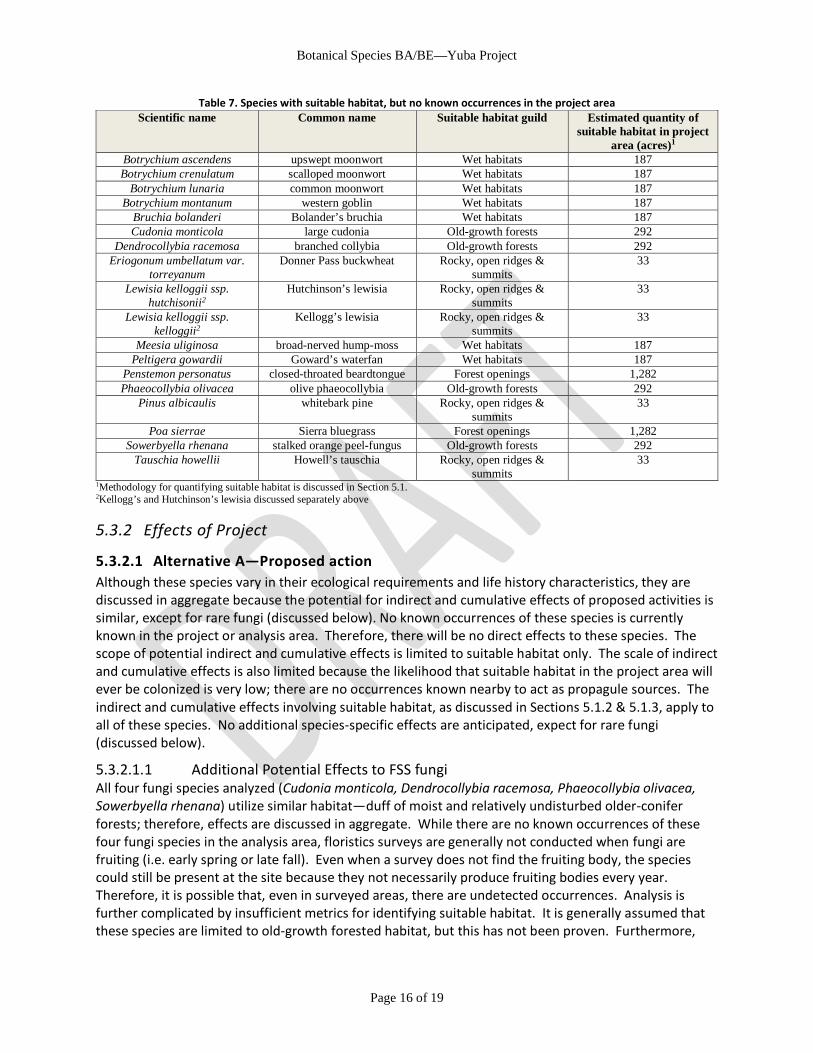
5.3 SPECIES WITH SUITABLE HABITAT, BUT NO OCCURRENCES IN PROJECT AREA
5.3.1 Existing Environment During surveys of the project area, suitable habitat was identified, but no occurrences were found for the species in Table 7. Unlike Kellogg’s and Hutchinson’s lewisia, based upon a review of GIS and survey reports, there is very low potential for suitable habitat for these TES botanical species among the unsurveyed areas where treatments are proposed.
Botanical Species BA/BE—Yuba Project
Page 16 of 19
Table 7. Species with suitable habitat, but no known occurrences in the project area Scientific name Common name Suitable habitat guild Estimated quantity of
suitable habitat in project area (acres)1
Botrychium ascendens upswept moonwort Wet habitats 187 Botrychium crenulatum scalloped moonwort Wet habitats 187
Botrychium lunaria common moonwort Wet habitats 187 Botrychium montanum western goblin Wet habitats 187
Bruchia bolanderi Bolander’s bruchia Wet habitats 187 Cudonia monticola large cudonia Old-growth forests 292
Dendrocollybia racemosa branched collybia Old-growth forests 292 Eriogonum umbellatum var.
torreyanum Donner Pass buckwheat Rocky, open ridges &
summits 33
Lewisia kelloggii ssp. hutchisonii2
Hutchinson’s lewisia Rocky, open ridges & summits
33
Lewisia kelloggii ssp. kelloggii2
Kellogg’s lewisia Rocky, open ridges & summits
33
Meesia uliginosa broad-nerved hump-moss Wet habitats 187 Peltigera gowardii Goward’s waterfan Wet habitats 187
Penstemon personatus closed-throated beardtongue Forest openings 1,282 Phaeocollybia olivacea olive phaeocollybia Old-growth forests 292
Pinus albicaulis whitebark pine Rocky, open ridges & summits
33
Poa sierrae Sierra bluegrass Forest openings 1,282 Sowerbyella rhenana stalked orange peel-fungus Old-growth forests 292
Tauschia howellii Howell’s tauschia Rocky, open ridges & summits
33
1Methodology for quantifying suitable habitat is discussed in Section 5.1. 2Kellogg’s and Hutchinson’s lewisia discussed separately above
5.3.2 Effects of Project
5.3.2.1 Alternative A—Proposed action Although these species vary in their ecological requirements and life history characteristics, they are discussed in aggregate because the potential for indirect and cumulative effects of proposed activities is similar, except for rare fungi (discussed below). No known occurrences of these species is currently known in the project or analysis area. Therefore, there will be no direct effects to these species. The scope of potential indirect and cumulative effects is limited to suitable habitat only. The scale of indirect and cumulative effects is also limited because the likelihood that suitable habitat in the project area will ever be colonized is very low; there are no occurrences known nearby to act as propagule sources. The indirect and cumulative effects involving suitable habitat, as discussed in Sections 5.1.2 & 5.1.3, apply to all of these species. No additional species-specific effects are anticipated, expect for rare fungi (discussed below).
5.3.2.1.1 Additional Potential Effects to FSS fungi All four fungi species analyzed (Cudonia monticola, Dendrocollybia racemosa, Phaeocollybia olivacea, Sowerbyella rhenana) utilize similar habitat—duff of moist and relatively undisturbed older-conifer forests; therefore, effects are discussed in aggregate. While there are no known occurrences of these four fungi species in the analysis area, floristics surveys are generally not conducted when fungi are fruiting (i.e. early spring or late fall). Even when a survey does not find the fruiting body, the species could still be present at the site because they not necessarily produce fruiting bodies every year. Therefore, it is possible that, even in surveyed areas, there are undetected occurrences. Analysis is further complicated by insufficient metrics for identifying suitable habitat. It is generally assumed that these species are limited to old-growth forested habitat, but this has not been proven. Furthermore,
Botanical Species BA/BE—Yuba Project
Page 17 of 19
identifying old-growth forested habitat at a landscape scale is very difficult; CHWR types and classes were used as the best available proxy (discussed in Section 4.1), but those likely substantially overestimate the extent of old-growth habitat. The use of Sporax to treat root disease has the potential to directly negatively affect FSS fungi, because boron—the active ingredient in Sporax—is an effective fungicide. However, the proposed application is restricted to cut stump surfaces, making direct effects are only possible if Sporax was spilled or misapplied. All FS pesticide applications must be conducted in accordance with State and Federal rules and regulations, which include are designed to prevent spill or drift. Therefore, it is unlikely that the proposed Sporax application will negatively affect FSS fungi. Because of the difficulty of detecting FSS fungi, analysis also focuses on whether the prerequisite conditions for fungal growth are maintained in areas of suitable habitat, namely: sufficient over story canopy, host trees, duff and large down wood; adequate soil moisture; and the integrity of duff / soil structure, function and biota. The complexity of these habitat factors makes it challenging to state the scope of the project’s impact on old growth habitat with a high degree of certainty. The proposed action will retain trees > 30” DBH in older forest habitats, providing sufficient host trees. Litter/duff and large down wood will be reduced during harvest and thinning, though some down wood will be retained. Over story canopy will be reduced, but not below 50%. None of the proposed activities are expect to alter long term soil moisture. Duff / soil structure, function and biota may be negatively affected by prescribed fire—particularly pile burning which concentrates fire intensity—but these effects are expected to be short-term and limited in scale. Overall, while there may be some short-term negative effects, it is anticipated that the project is not likely to result in large-scale or long-term negative effects to FSS fungi habitat.
5.3.2.2 Alternative B—No action If the project was not undertaken, there would be no direct effects to these species and negligible indirect effects to their habitat.
5.3.2.3 Alternative C—Wildlife focus The difference between Alternative A and Alternative C are negligible. Nearly all of the impacts discussed under Alternative A would occur under Alternative C. The only notable difference is that the reduction in mechanical thinning in Alternative C would reduce the acreage of ground disturbance in forest opening and old-growth forest habitat (~12 ac). This would result in a very slight reduction of the following: short-term negative effects to forest opening and old-growth forest habitat, potential long-term negative effects to FSS fungi and long-term beneficial effects to forest opening and old-growth forest habitat. Nonetheless, these impacts still fall far below the threshold of significance.
5.3.3 Determination It is my determination that all alternatives (A,B,C) of the Yuba project will not affect: upswept moonwort (Botrychium ascendens); scalloped moonwort (Botrychium crenulatum); common moonwort (Botrychium lunaria); western goblin (Botrychium montanum); Bolander’s bruchia (Bruchia bolanderi); Donner Pass buckwheat (Eriogonum umbellatum var. torreyanum); broad-nerved hump-moss (Meesia uliginosa); Goward’s waterfan (Peltigera gowardii); closed-throated beardtongue (Penstemon personatus); whitebark pine (Pinus albicaulis); Sierra bluegrass (Poa sierrae); and Howell’s tauschia (Tauschia howellii). My determination is based on the lack of occurrences and the negligible impacts to suitable habitat within the project area.
Botanical Species BA/BE—Yuba Project
Page 18 of 19
It is my determination that both action alternatives (A,C) of the Yuba project may affect individuals but is not likely to result in a trend toward federal listing for large cudonia (Cudonia monticola), branched collybia (Dendrocollybia racemosa), olive phaeocollybia (Phaeocollybia olivacea), and stalked orange peel-fungus (Sowerbyella rhenana). My determination is based upon the following: lack of known occurrences in the project area; there is the potential for short-term negative impacts to suitable habitat; and the included management requirements are sufficient to maintain or improve suitable habitat. It is my determination that the no-action alternative (B) of the Yuba project will not affect: large cudonia (Cudonia monticola), branched collybia (Dendrocollybia racemosa), olive phaeocollybia (Phaeocollybia olivacea), and stalked orange peel-fungus (Sowerbyella rhenana). My determination is based on the lack of occurrences and the negligible impacts to suitable habitat within the project area.
5.4 OTHER BOTANICAL RESOURCES Other botanical resources—such as specially designated management areas and TNF Watch list species and communities—are addressed in the project’s Other Botanical Resources Assessment.
6 COMPLIANCE WITH CURRENT MANAGEMENT DIRECTION Proposed action can be implemented in a manner that is consistent with the Forest Plan as amended (USDA Forest Service 1990, 2004b). Forest Service Sensitive botanical species are protected as needed to maintain viability.
7 REFERENCES Baldwin, B.G.; Goldman, D.H.; Keil, D.J. [and others]. 2012. The Jepson manual: vascular plants of California, second
edition. Berkeley, CA: University of California Press.
Brooks, M. 2007. Effects of Land Management Practices on Plant Invasions in Wildland Areas. In: Nentwig, W., ed. Biological Invasions. Ecolgoical Studies: 147-162.
CalFire. 2015. Forest Practices Geographic Information System. Sacramento, CA: ftp://ftp.fire.ca.gov/forest
California Department of Fish and Game. 1988. A Guide to Wildlife Habitats of California. Sacramento, CA: State of California, Resources Agency, Department of Fish and Game. 166 p.
California Department of Fish and Wildlife. 2016. California Natural Diversity Database, RareFind Version 5. http://www.dfg.ca.gov/biogeodata/cnddb/mapsanddata.asp. (01 January 2016).
California Native Plant Society. 2016. Inventory of Rare and Endangered Plants. Sacramento, CA: (01 January 2016).
Gross, S.; Coppoletta, M. 2013. Historic Range of Variability for Meadows in the Sierra Nevada and South Cascades. Unpublished report on file at R5 Ecology Program. Vallejo, CA: USDA Forest Service, Pacific Southwest Region, Ecology Program.
Helms, J.A. 1987. Invasion of Pinus contorta var. murrayana (Pinaceae) into mountain meadows at Yosemite National Park, California. Madrono. 34(2): 91-97.
Hobbs, R.J.; Huenneke, L.F. 1992. Disturbance, diversity, and invasion: implications for conservation. Conservation Biology. 6: 324-337.
Lonsdale, W.M. 1999. Global patterns of plant invasions and the concept of invasibility. Ecology. 80: 1522-1536.
McCullough, S.A.; O'Geen, A.T.; Whiting, M.L. [and others]. 2013. Quantifying the consequences of conifer succession in aspen stands: decline in a biodiversity-supporting community. Environmental Monitoring and Assessment. 185(7): 5563-5576. DOI: 10.1007/s10661-012-2967-4.
Botanical Species BA/BE—Yuba Project
Page 19 of 19
NatureServe. 2015. NatureServe Explorer: Online Encyclopedia of Life [web application], Version 7.1. Arlington, Virginia. http://www.natureserve.org/explorer/. (January 2016).
Ornduff, R.; Faber, P.M.; Keeler-Wolf, T.; Gaede, P. 2003. Introduction to California Plant Life, Revised Edition. California Natural History Guides. Vol. 69. Berkeley, CA: University of California Press. 357 p.
Radosevich, S. 2002. Plant Invasion and Their Management, Chapter 4. Invasive Plant Management: CIPM Online. Bozeman, MT: Center for Invasive Plant Management: http://www.weedcenter.org/textbook/index.html (26 December 2012).
Shepperd, W.D.; Rogers, P.C.; Burton, D.; Bartos, D.L. 2006. Ecology, biodiversity, management, and restoration of aspen in the Sierra Nevada. Gen. Tech. Rep. RMRS-GTR-178. Fort Collins, CO: USDA Forest Service, Rocky Mountain Research Station. 122 p. p.
Shevock, J. 1996. Status of Rare and Endemic Plants. In: Sierra Nevada Ecosystem Project Final Report to Congress, Vol II, Assessments and scientific basis for management options. Davis, CA: Centers for Water and Wildland Resources, University of California, Davis.
Slakey, D.; Sims, A.E.; Lazar, K. 2013. Rare Plant Status Review: Lewisia kelloggii ssp. kelloggii. Proposed Addition to California Rare Plant Rank 3.2, G3G4T2T3Q / S2S3Rare Plant Status Review: Lewisia kelloggii ssp. kelloggii. Proposed Addition to California Rare Plant Rank 3.2, G3G4T2T3Q / S2S3. Unpublished paper. 3 p. p.
USDA Farm Service Agency. 2014. California National Agriculture Imagery Program (NAIP) Imagery. Salt Lake City, UT:
USDA Forest Service. 1990. Tahoe National Forest Land And Resource Management Plan. Nevada City, CA: USDA Forest Service, Pacific Southwest Region.
USDA Forest Service. 2004a. Sierra Nevada Forest Plan Amendment Final Supplemental Environmental Impact Statement. Vallejo, CA: USDA Forest Service, Pacific Southwest Region.
USDA Forest Service. 2004b. Sierra Nevada Forest Plan Amendment Record of Decision. Vallejo, CA: USDA Forest Service, Pacific Southwest Region.
USDA Forest Service. 2009. CALVEG_Tiles_Ecoregions07_4 (GIS vector data). McClellan, CA: USDA Forest Service, Pacific Southwest Region, Remote Sensing Lab. http://www.fs.fed.us/r5/rsl/clearinghouse/gis-download.shtml
USDA Forest Service. 2013. Letter from Regional Forester (R. Moore) to Forest Supervisors Regarding Update to the Regional Forester's Sensitive Species List, Dated 03 July 2013, File Code: 2670. Vallejo, CA: USDA Forest Service, Pacific Southwest Region.
USDA Forest Service. 2015a. Meadow dataset for Tahoe National Forest. Nevada City, CA:
USDA Forest Service. 2015b. National Hydrography Dataset (NHD) Flowlines and Areas for Tahoe National Forest. Nevada City, CA:
USDA Forest Service. 2015c. Threatened, Endangered, and Sensitive Plant and Invasive Species (TESP-IS) Data for Tahoe National Forest, Natural Resource Information System (NRIS).
Vale, T.R. 1987. Vegetation change and park purposes in the high elevations of Yosemite National Park, California. Annals of the Association of American Geographers. 77(1): 1-18. DOI: 10.1111/j.1467-8306.1987.tb00141.x.
Wilcove, D.S.; Rothstein, D.; Dubow, J. [and others]. 1998. Quantifying threats to imperiled species in the United States. Bioscience. 48(8): 607-615.

Botanical Species BA/BE—Yuba Project
A-1
APPENDIX A. MAPS
Figure 1. Proposed units and botanical analysis area
0103
06
12
16
1722
28
02
2131
07
43
4445
1134
33
4041
4204
0426
27
3030
13
51
F
14
14
1420
57
58
36
2405
54
55
AC
D
E
G
H
I
J
23
77
82
78
74
7676
71
75
70
72
85
7373
100
60
83
G-M
79
102103
104
105
101
106
106107
BB1
10
115
114
Map produced by D
istrict Botanist 20160
1M
iles
BotanyAnalysisArea
Project ProposalsProposal
Hand cut
Mechanical Thin
Meadow R
estoration
Powerline Haz Tree & Veg
Underburn or Helitorch
Transportation SystemRoad C
losed to Vehicular Traffic (ML1)
Dirt Road (M
L2)Im
proved Road (M
L3-5)County R
oadState H
ighway
Interstate Highw
ayM
otorized TrailNon-M
otorized Trail
´
Botanical Species BA/BE—Yuba Project
B-1
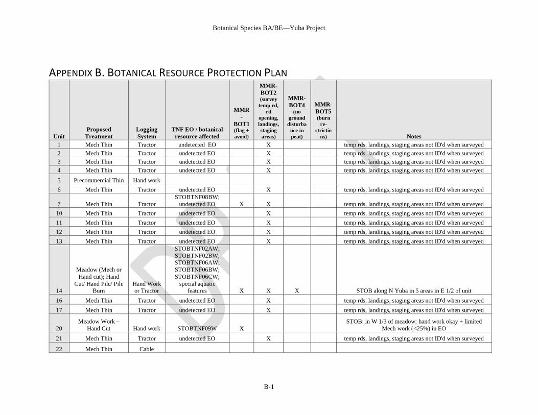
APPENDIX B. BOTANICAL RESOURCE PROTECTION PLAN
Unit Proposed
Treatment Logging System
TNF EO / botanical resource affected
MMR-
BOT1 (flag + avoid)
MMR-BOT2 (survey
temp rd, rd
opening, landings, staging areas)
MMR-BOT4
(no ground disturba
nce in peat)
MMR-BOT5 (burn
re-strictio
ns) Notes 1 Mech Thin Tractor undetected EO X temp rds, landings, staging areas not ID'd when surveyed 2 Mech Thin Tractor undetected EO X temp rds, landings, staging areas not ID'd when surveyed 3 Mech Thin Tractor undetected EO X temp rds, landings, staging areas not ID'd when surveyed 4 Mech Thin Tractor undetected EO X temp rds, landings, staging areas not ID'd when surveyed
5 Precommercial Thin Hand work 6 Mech Thin Tractor undetected EO X temp rds, landings, staging areas not ID'd when surveyed
7 Mech Thin Tractor STOBTNF08BW;
undetected EO X X temp rds, landings, staging areas not ID'd when surveyed 10 Mech Thin Tractor undetected EO X temp rds, landings, staging areas not ID'd when surveyed 11 Mech Thin Tractor undetected EO X temp rds, landings, staging areas not ID'd when surveyed 12 Mech Thin Tractor undetected EO X temp rds, landings, staging areas not ID'd when surveyed 13 Mech Thin Tractor undetected EO X temp rds, landings, staging areas not ID'd when surveyed
14
Meadow (Mech or Hand cut); Hand
Cut/ Hand Pile/ Pile Burn
Hand Work or Tractor
STOBTNF02AW; STOBTNF02BW; STOBTNF06AW; STOBTNF06BW; STOBTNF06CW;
special aquatic features X X X STOB along N Yuba in 5 areas in E 1/2 of unit
16 Mech Thin Tractor undetected EO X temp rds, landings, staging areas not ID'd when surveyed 17 Mech Thin Tractor undetected EO X temp rds, landings, staging areas not ID'd when surveyed
20 Meadow Work –
Hand Cut Hand work STOBTNF09W X STOB: in W 1/3 of meadow; hand work okay + limited
Mech work (<25%) in EO
21 Mech Thin Tractor undetected EO X temp rds, landings, staging areas not ID'd when surveyed
22 Mech Thin Cable
Botanical Species BA/BE—Yuba Project
B-2
Unit Proposed
Treatment Logging System
TNF EO / botanical resource affected
MMR-
BOT1 (flag + avoid)
MMR-BOT2 (survey
temp rd, rd
opening, landings, staging areas)
MMR-BOT4
(no ground disturba
nce in peat)
MMR-BOT5 (burn
re-strictio
ns) Notes
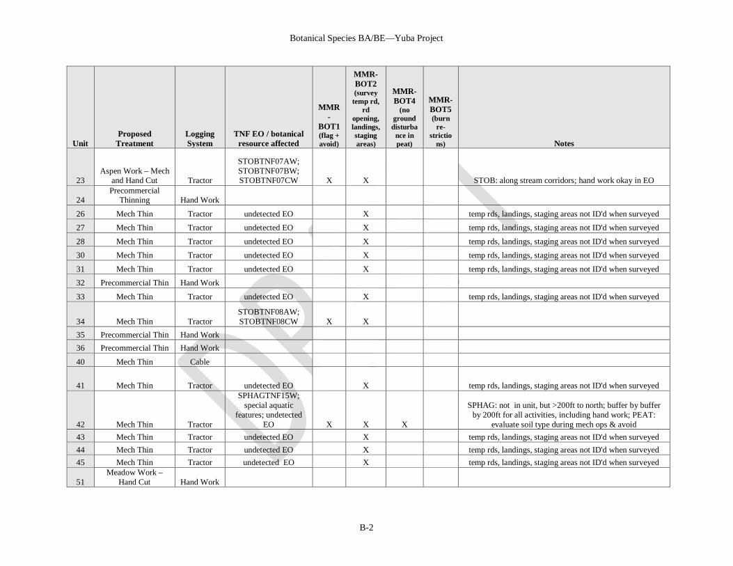
23 Aspen Work – Mech
and Hand Cut Tractor
STOBTNF07AW; STOBTNF07BW; STOBTNF07CW X X STOB: along stream corridors; hand work okay in EO
24 Precommercial
Thinning Hand Work
26 Mech Thin Tractor undetected EO X temp rds, landings, staging areas not ID'd when surveyed
27 Mech Thin Tractor undetected EO X temp rds, landings, staging areas not ID'd when surveyed
28 Mech Thin Tractor undetected EO X temp rds, landings, staging areas not ID'd when surveyed
30 Mech Thin Tractor undetected EO X temp rds, landings, staging areas not ID'd when surveyed
31 Mech Thin Tractor undetected EO X temp rds, landings, staging areas not ID'd when surveyed
32 Precommercial Thin Hand Work
33 Mech Thin Tractor undetected EO X temp rds, landings, staging areas not ID'd when surveyed
34 Mech Thin Tractor STOBTNF08AW; STOBTNF08CW X X
35 Precommercial Thin Hand Work 36 Precommercial Thin Hand Work
40 Mech Thin Cable
41 Mech Thin Tractor undetected EO X temp rds, landings, staging areas not ID'd when surveyed
42 Mech Thin Tractor
SPHAGTNF15W; special aquatic
features; undetected EO X X X
SPHAG: not in unit, but >200ft to north; buffer by buffer by 200ft for all activities, including hand work; PEAT:
evaluate soil type during mech ops & avoid 43 Mech Thin Tractor undetected EO X temp rds, landings, staging areas not ID'd when surveyed 44 Mech Thin Tractor undetected EO X temp rds, landings, staging areas not ID'd when surveyed 45 Mech Thin Tractor undetected EO X temp rds, landings, staging areas not ID'd when surveyed
51 Meadow Work –
Hand Cut Hand Work
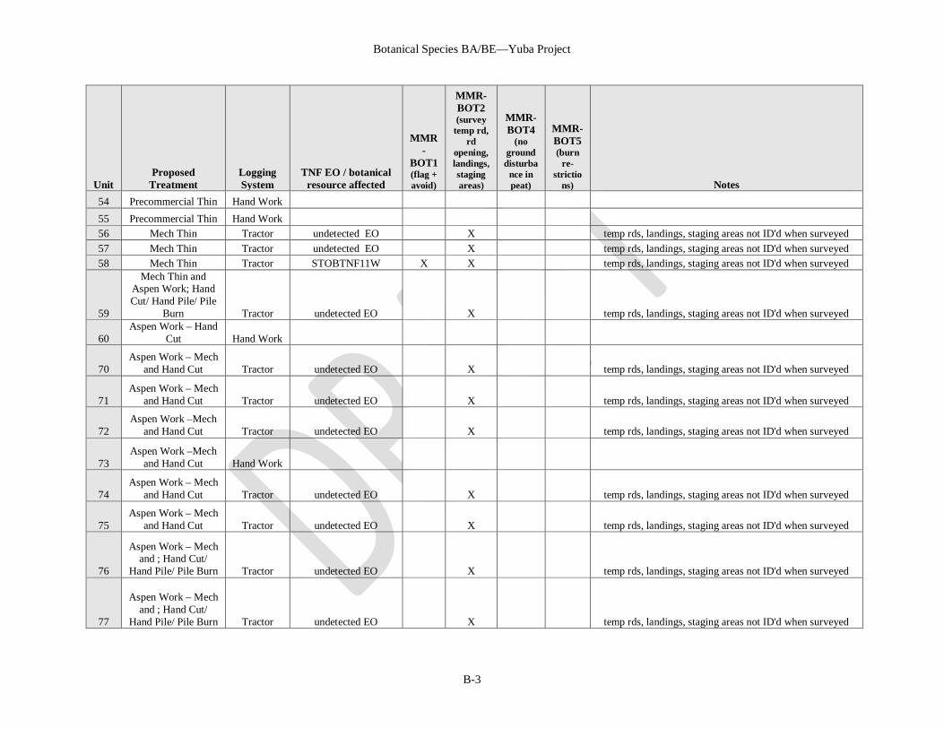
Botanical Species BA/BE—Yuba Project
B-3
Unit Proposed
Treatment Logging System
TNF EO / botanical resource affected
MMR-
BOT1 (flag + avoid)
MMR-BOT2 (survey
temp rd, rd
opening, landings, staging areas)
MMR-BOT4
(no ground disturba
nce in peat)
MMR-BOT5 (burn
re-strictio
ns) Notes 54 Precommercial Thin Hand Work 55 Precommercial Thin Hand Work 56 Mech Thin Tractor undetected EO X temp rds, landings, staging areas not ID'd when surveyed 57 Mech Thin Tractor undetected EO X temp rds, landings, staging areas not ID'd when surveyed 58 Mech Thin Tractor STOBTNF11W X X temp rds, landings, staging areas not ID'd when surveyed
59
Mech Thin and Aspen Work; Hand Cut/ Hand Pile/ Pile
Burn Tractor undetected EO X temp rds, landings, staging areas not ID'd when surveyed
60 Aspen Work – Hand
Cut Hand Work
70 Aspen Work – Mech
and Hand Cut Tractor undetected EO X temp rds, landings, staging areas not ID'd when surveyed
71 Aspen Work – Mech
and Hand Cut Tractor undetected EO X temp rds, landings, staging areas not ID'd when surveyed
72 Aspen Work –Mech
and Hand Cut Tractor undetected EO X temp rds, landings, staging areas not ID'd when surveyed
73 Aspen Work –Mech
and Hand Cut Hand Work
74 Aspen Work – Mech
and Hand Cut Tractor undetected EO X temp rds, landings, staging areas not ID'd when surveyed
75 Aspen Work – Mech
and Hand Cut Tractor undetected EO X temp rds, landings, staging areas not ID'd when surveyed
76
Aspen Work – Mech and ; Hand Cut/
Hand Pile/ Pile Burn Tractor undetected EO X temp rds, landings, staging areas not ID'd when surveyed
77
Aspen Work – Mech and ; Hand Cut/
Hand Pile/ Pile Burn Tractor undetected EO X temp rds, landings, staging areas not ID'd when surveyed
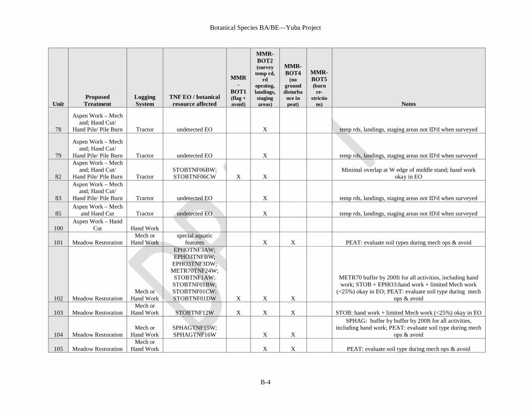
Botanical Species BA/BE—Yuba Project
B-4
Unit Proposed
Treatment Logging System
TNF EO / botanical resource affected
MMR-
BOT1 (flag + avoid)
MMR-BOT2 (survey
temp rd, rd
opening, landings, staging areas)
MMR-BOT4
(no ground disturba
nce in peat)
MMR-BOT5 (burn
re-strictio
ns) Notes
78
Aspen Work – Mech and; Hand Cut/
Hand Pile/ Pile Burn Tractor undetected EO X temp rds, landings, staging areas not ID'd when surveyed
79
Aspen Work – Mech and; Hand Cut/
Hand Pile/ Pile Burn Tractor undetected EO X temp rds, landings, staging areas not ID'd when surveyed
82
Aspen Work – Mech and; Hand Cut/
Hand Pile/ Pile Burn Tractor STOBTNF06BW; STOBTNF06CW X X
Minimal overlap at W edge of middle stand; hand work okay in EO
83
Aspen Work – Mech and; Hand Cut/
Hand Pile/ Pile Burn Tractor undetected EO X temp rds, landings, staging areas not ID'd when surveyed
85 Aspen Work – Mech
and Hand Cut Tractor undetected EO X temp rds, landings, staging areas not ID'd when surveyed
100 Aspen Work – Hand
Cut Hand Work
101 Meadow Restoration Mech or
Hand Work special aquatic
features X X PEAT: evaluate soil types during mech ops & avoid
102 Meadow Restoration Mech or
Hand Work
EPHOTNF3AW; EPHO3TNFBW;
EPHO3TNF3DW; METR70TNF24W;
STOBTNF1AW; STOBTNF01BW; STOBTNF01CW; STOBTNF01DW X X X
METR70 buffer by 200ft for all activities, including hand work; STOB + EPHO3:hand work + limited Mech work
(<25%) okay in EO; PEAT: evaluate soil type during mech ops & avoid
103 Meadow Restoration Mech or
Hand Work STOBTNF12W X X X STOB: hand work + limited Mech work (<25%) okay in EO
104 Meadow Restoration Mech or
Hand Work SPHAGTNF15W; SPHAGTNF16W X X
SPHAG: buffer by buffer by 200ft for all activities, including hand work; PEAT: evaluate soil type during mech
ops & avoid
105 Meadow Restoration Mech or
Hand Work X X PEAT: evaluate soil type during mech ops & avoid
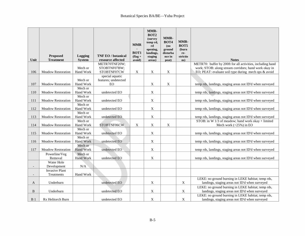
Botanical Species BA/BE—Yuba Project
B-5
Unit Proposed
Treatment Logging System
TNF EO / botanical resource affected
MMR-
BOT1 (flag + avoid)
MMR-BOT2 (survey
temp rd, rd
opening, landings, staging areas)
MMR-BOT4
(no ground disturba
nce in peat)
MMR-BOT5 (burn
re-strictio
ns) Notes
106 Meadow Restoration Mech or
Hand Work
METR70TNF20W; STOBTNF07BW; STOBTNF07CW X X X
METR70: buffer by 200ft for all activities, including hand work; STOB: along stream corridors; hand work okay in EO; PEAT: evaluate soil type during mech ops & avoid
107 Meadow Restoration Mech or
Hand Work
special aquatic features; undetected
EO X X temp rds, landings, staging areas not ID'd when surveyed
110 Meadow Restoration Mech or
Hand Work undetected EO X temp rds, landings, staging areas not ID'd when surveyed
111 Meadow Restoration Mech or
Hand Work undetected EO X temp rds, landings, staging areas not ID'd when surveyed
112 Meadow Restoration Mech or
Hand Work undetected EO X temp rds, landings, staging areas not ID'd when surveyed
113 Meadow Restoration Mech or
Hand Work undetected EO X temp rds, landings, staging areas not ID'd when surveyed
114 Meadow Restoration Mech or
Hand Work STOBTNF06CW X X X STOB: in W 1/3 of meadow; hand work okay + limited
Mech work (<25%) in EO
115 Meadow Restoration Mech or
Hand Work undetected EO X temp rds, landings, staging areas not ID'd when surveyed
116 Meadow Restoration Mech or
Hand Work undetected EO X temp rds, landings, staging areas not ID'd when surveyed
117 Meadow Restoration Mech or
Hand Work undetected EO X temp rds, landings, staging areas not ID'd when surveyed
Powerline/Veg
Removal Mech or
Hand Work undetected EO X temp rds, landings, staging areas not ID'd when surveyed
- Water Hole
Development N/A
- Invasive Plant
Treatments Hand Work
A Underburn undetected EO X X LEKE: no ground burning in LEKE habitat; temp rds,
landings, staging areas not ID'd when surveyed
B Underburn undetected EO X X LEKE: no ground burning in LEKE habitat; temp rds,
landings, staging areas not ID'd when surveyed
B 1 Rx Helitorch Burn undetected EO X X LEKE: no ground burning in LEKE habitat; temp rds,
landings, staging areas not ID'd when surveyed
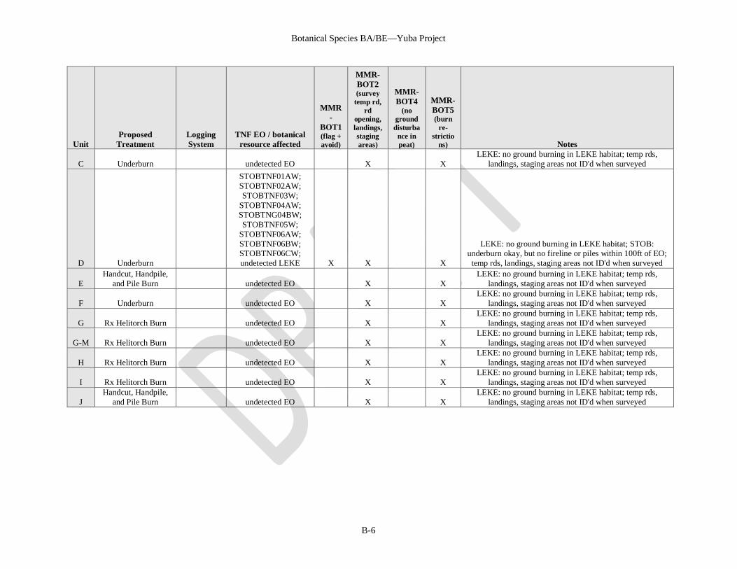
Botanical Species BA/BE—Yuba Project
B-6
Unit Proposed
Treatment Logging System
TNF EO / botanical resource affected
MMR-
BOT1 (flag + avoid)
MMR-BOT2 (survey
temp rd, rd
opening, landings, staging areas)
MMR-BOT4
(no ground disturba
nce in peat)
MMR-BOT5 (burn
re-strictio
ns) Notes
C Underburn undetected EO X X LEKE: no ground burning in LEKE habitat; temp rds,
landings, staging areas not ID'd when surveyed
D Underburn
STOBTNF01AW; STOBTNF02AW; STOBTNF03W;
STOBTNF04AW; STOBTNG04BW; STOBTNF05W;
STOBTNF06AW; STOBTNF06BW; STOBTNF06CW; undetected LEKE X X X
LEKE: no ground burning in LEKE habitat; STOB: underburn okay, but no fireline or piles within 100ft of EO; temp rds, landings, staging areas not ID'd when surveyed
E Handcut, Handpile,
and Pile Burn undetected EO X X LEKE: no ground burning in LEKE habitat; temp rds,
landings, staging areas not ID'd when surveyed
F Underburn undetected EO X X LEKE: no ground burning in LEKE habitat; temp rds,
landings, staging areas not ID'd when surveyed
G Rx Helitorch Burn undetected EO X X LEKE: no ground burning in LEKE habitat; temp rds,
landings, staging areas not ID'd when surveyed
G-M Rx Helitorch Burn undetected EO X X LEKE: no ground burning in LEKE habitat; temp rds,
landings, staging areas not ID'd when surveyed
H Rx Helitorch Burn undetected EO X X LEKE: no ground burning in LEKE habitat; temp rds,
landings, staging areas not ID'd when surveyed
I Rx Helitorch Burn undetected EO X X LEKE: no ground burning in LEKE habitat; temp rds,
landings, staging areas not ID'd when surveyed
J Handcut, Handpile,
and Pile Burn undetected EO X X LEKE: no ground burning in LEKE habitat; temp rds,
landings, staging areas not ID'd when surveyed