Embed Size (px)
Citation preview
page 1
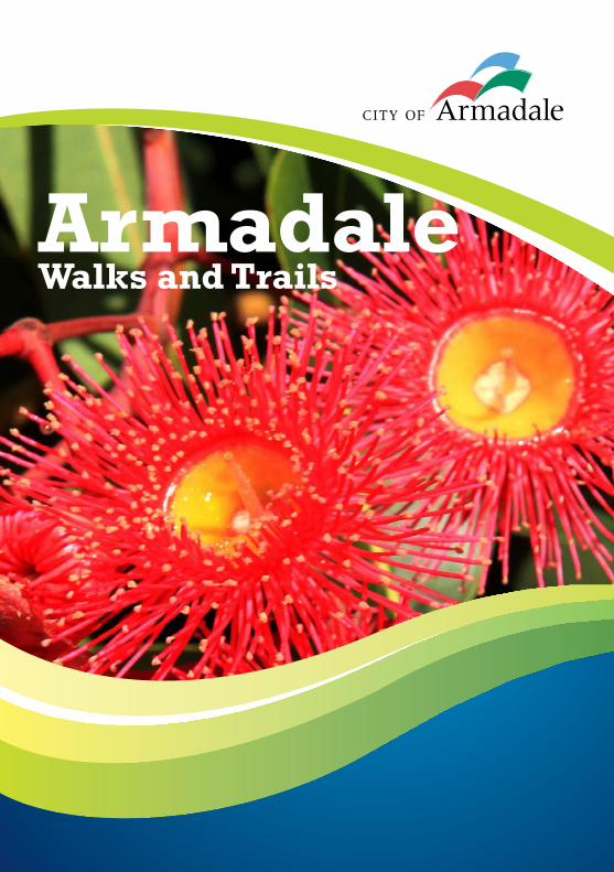
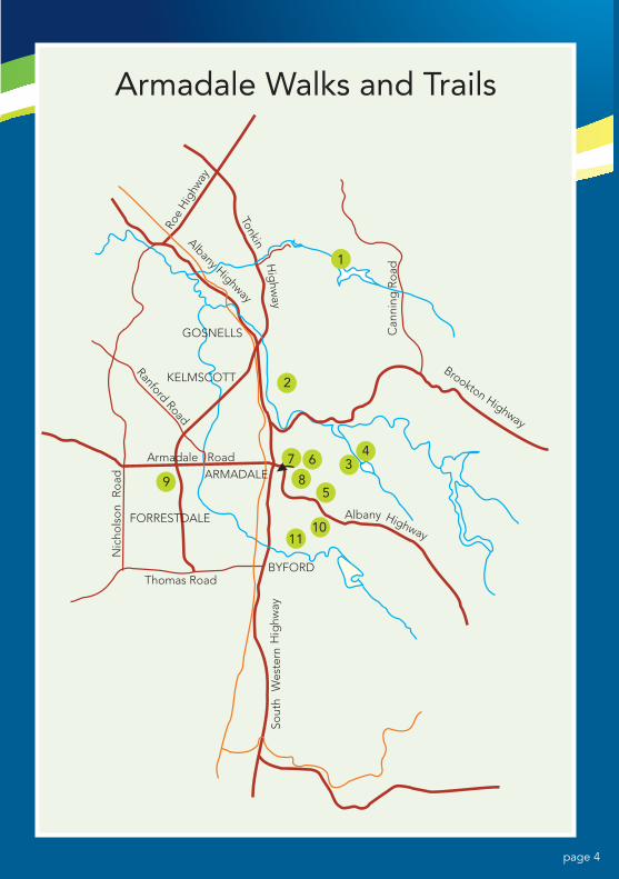
Armadale Walks and Trails
page 1
WHEN BUSHWALKING
Personal safety when bushwalking is a matter of consideration and common sense.
DO
• Wearsuitableshoesandclothing.• Takeahatandsunprotection.• Takeplentyofwaterwithyou.• Tellsomeonewhereyouaregoing,andwhenyouwillreturn.• Takeallofyourrubbishawaywithyou.• Removevaluablesfromsightandlock-upwhenyouleaveyourcar.• Enjoyyourwalk.
DON’T
• Wanderawayfromthedesignatedtrail.• Pickwildflowersornativeflora-itisanoffence.• Lightfires,unlessinanareadesignatedforthepurpose.• Alwaysbeawareofthefirewarningforecasts.• Takepetswithyouunlessyouhavecheckedthattheyarepermittedinthe
area.PetsareNOTallowedinnationalparks,inwatercatchmentareasorinnaturereserves.
• Disturbnativefauna,logsorrocks.thatmayprovidehabitatforfauna.
DISCLAIMER
Whilsteveryefforthasbeenmadetoensurethatallinformationcontainedwithin this publication is correct at the time of printing it is intended as a general guideonly.TheCityofArmadale(TheCity)acceptsnoresponsibility,asfaraspermittedbylaw,foranyloss,damage,accidents,injuriesordeathsthatmayoccurasaresultofanyalterations,modifications,deteriorationoranyunforeseeneventoractivityoutsideoftheCity’scontrolthataffectsthelayout,terrain,directionorgeneralconditionofthetrailslisted.Walkersareresponsibleformaintainingtheirownsafetyandwelfare(orthatofchildrenundertheirsupervisionorcontrol)andshouldalwayscheckweatherandfireconditionspriorto departure and ensure they carry all appropriate equipment that is appropriate forthejourneyandtheirsafereturn.
NOTE: Maps are not to scale.
page 2
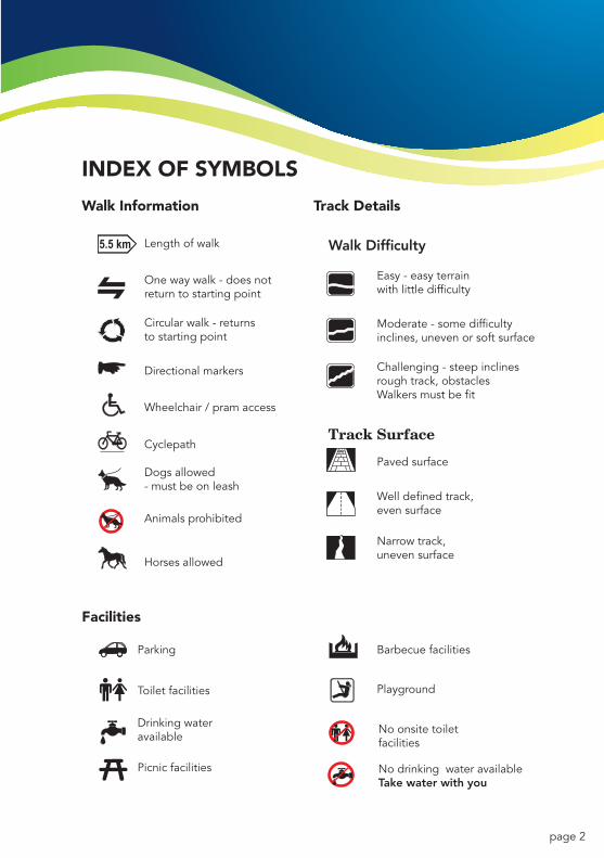
Length of walk
Walk Information
Facilities
Track Details
Walk Difficulty
Easy - easy terrainwith little difficulty
Moderate - some difficultyinclines, uneven or soft surface
Challenging - steep inclinesrough track, obstaclesWalkers must be fit
Paved surface
Well defined track,even surface
Narrow track,uneven surface
Parking
No onsite toilet facilities
No drinking water availableTake water with you
Toilet facilities
Drinking wateravailable
Picnic facilities
Barbecue facilities
Playground
One way walk - does notreturn to starting point
Circular walk - returns to starting point
Directional markers
Wheelchair / pram access
Cyclepath
Dogs allowed- must be on leash
Animals prohibited
Horses allowed
INDEx Of SyMBOLS
page 3
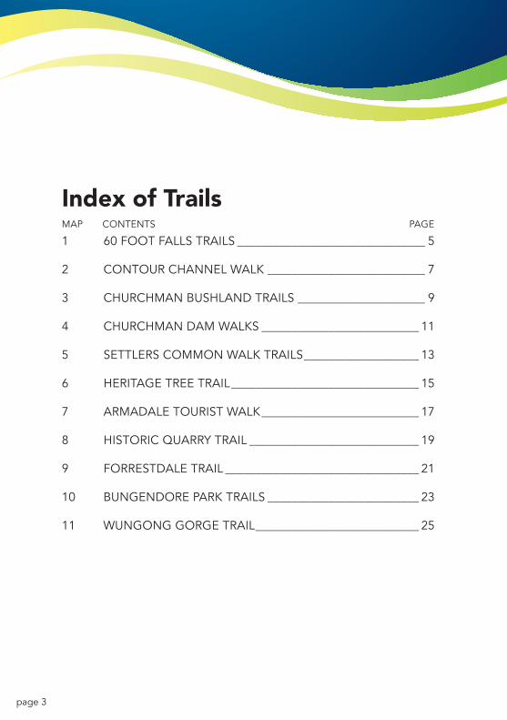
Index of TrailsMAPCONTENTSPAGE
160FOOTFALLSTRAILS _______________________________ 5
2CONTOURCHANNELWALK __________________________ 7
3CHURCHMANBUSHLANDTRAILS _____________________ 9
4CHURCHMANDAMWALKS __________________________ 11
5SETTLERSCOMMONWALKTRAILS ___________________ 13
6HERITAGETREETRAIL _______________________________ 15
7ARMADALETOURISTWALK __________________________ 17
8HISTORICQUARRYTRAIL ____________________________ 19
9FORRESTDALETRAIL ________________________________ 21
10BUNGENDOREPARKTRAILS _________________________ 23
11WUNGONGGORGETRAIL ___________________________ 25
page 4
1
2
34
5
67
89
1011
Roe
Hig
hway
TonkinH
ighw
ay
Can
ning
Ro
ad
Albany Highway
GOSNELLS
ARMADALE
BYFORD
Ranford Road
Thomas Road
Albany
Brookton Highway
Highway
Hig
hway
Wes
tern
Sout
h
Ro
adN
icho
lso
n
Armadale Walks and Trails
Armadale Road
FORRESTDALE
KELMSCOTT
page 5
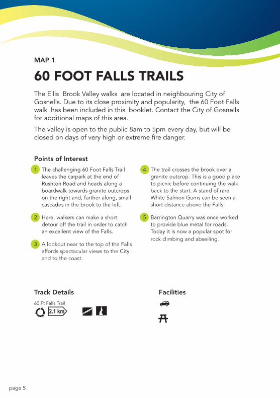
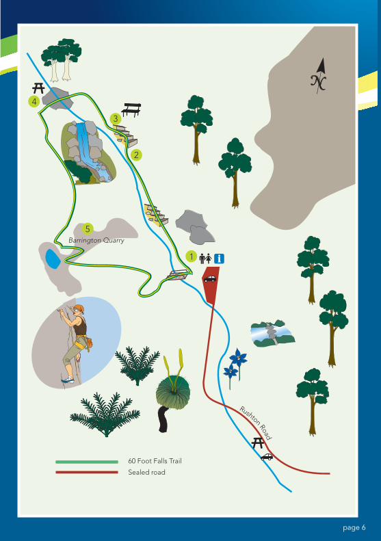
MAP 1
60 fOOT fALLS TRAILSTheEllisBrookValleywalksarelocatedinneighbouringCityofGosnells.Duetoitscloseproximityandpopularity,the60FootFallswalkhasbeenincludedinthisbooklet.ContacttheCityofGosnellsfor additional maps of this area.
Thevalleyisopentothepublic8amto5pmeveryday,butwillbeclosedondaysofveryhighorextremefiredanger.
Points of Interest
1 Thechallenging60FootFallsTrailleavesthecarparkattheendofRushtonRoadandheadsalongaboardwalk towards granite outcrops ontherightand,furtheralong,smallcascades in the brook to the left.
2 Here,walkerscanmakeashortdetour off the trail in order to catch anexcellentviewoftheFalls.
3 AlookoutneartothetopoftheFallsaffordsspectacularviewstotheCityand to the coast.
4 Thetrailcrossesthebrookoveragraniteoutcrop.Thisisagoodplaceto picnic before continuing the walk backtothestart.AstandofrareWhiteSalmonGumscanbeseenashortdistanceabovetheFalls.
5 BarringtonQuarrywasonceworkedtoprovidebluemetalforroads.Todayitisnowapopularspotforrock climbing and abseiling.
Wandoo Woodlands Loop
60 Ft Falls Trail
Track Details Facilities
page 6
60 Foot Falls Trail
Sealed road
Barrington Quarry
Rushton Road3
4
2
5
1
page 7
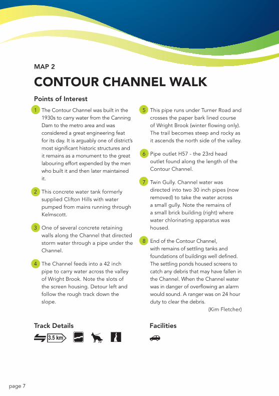
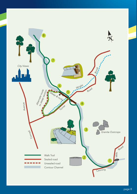
MAP 2
CONTOUR CHANNEL WALKPoints of Interest
1 TheContourChannelwasbuiltinthe1930stocarrywaterfromtheCanningDamtothemetroareaandwasconsidered a great engineering feat foritsday.Itisarguablyoneofdistrict’smost significant historic structures and it remains as a monument to the great labouringeffortexpendedbythemenwho built it and then later maintained it.
2 ThisconcretewatertankformerlysuppliedCliftonHillswithwaterpumped from mains running through Kelmscott.
3 OneofseveralconcreteretainingwallsalongtheChannelthatdirectedstorm water through a pipe under the Channel.
4 TheChannelfeedsintoa42inchpipetocarrywateracrossthevalleyofWrightBrook.Notetheslotsofthescreenhousing.Detourleftandfollow the rough track down the slope.
5 ThispiperunsunderTurnerRoadandcrosses the paper bark lined course ofWrightBrook(winterflowingonly).Thetrailbecomessteepandrockyasitascendsthenorthsideofthevalley.
6 PipeoutletH57-the23rdheadoutlet found along the length of the ContourChannel.
7 TwinGully.Channelwaterwasdirectedintotwo30inchpipes(nowremoved)totakethewateracrossa small gully. Note the remains of asmallbrickbuilding(right)wherewater chlorinating apparatus was housed.
8 EndoftheContourChannel,with remains of settling tanks and foundations of buildings well defined. ThesettlingpondshousedscreenstocatchanydebristhatmayhavefallenintheChannel.WhentheChannelwaterwasindangerofoverflowinganalarmwouldsound.Arangerwason24hourduty to clear the debris.
(KimFletcher)
Track Details FacilitiesTrack Details Facilities
page 8
8
7
6
Turn
er
Road
Canning
Walk Trail
Sealed road
Unsealed road
Contour Channel
Mill
s
Road
Con
nell
Ave
nue
City Views
Steep & rocky
Alte
rnat
e ro
ute
to s
teep
sec
tion
Wright
Broo
k
Granite Outcrops
5
4
3
21
page 9
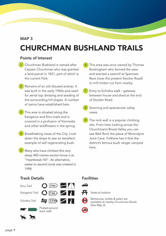
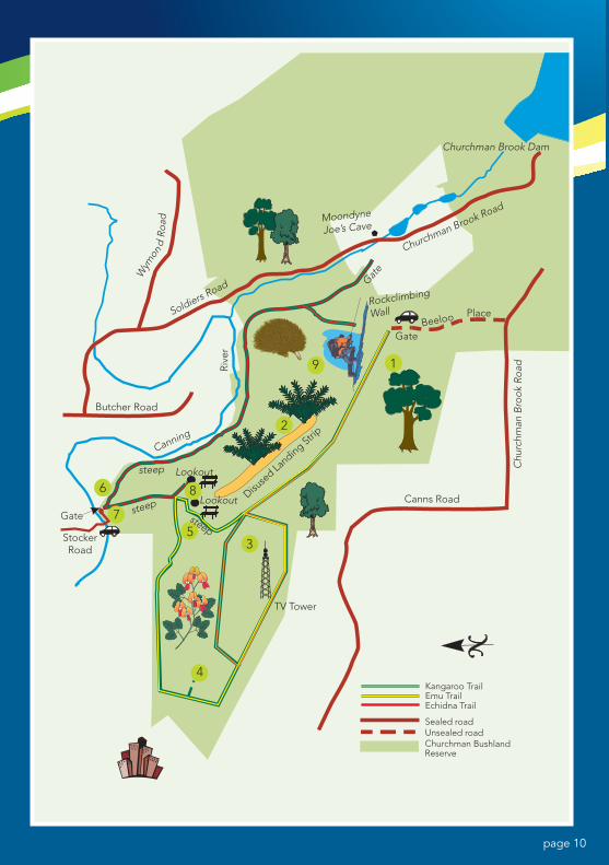
MAP 3
CHURCHMAN BUSHLAND TRAILSPoints of Interest
1 ChurchmanBushlandisnamedafterCaptainChurchmanwhowasgrantedalandparcelin1831,partofwhichisthe current Park.
2 Remainsofanolddisusedairstrip.Itwas built in the early 1960s and used for aerial top dressing and seeding of thesurroundinghillslopes.Anumberofzamiahaveestablishedhere.
3 ThisareaissituatedalongtheKangarooandEmutrailsandiscoveredinaprofusionofKennediaand other wildflowers in the spring.
4 BreathtakingviewsoftheCity.Lookdowntheslopetoseeanexcellentexampleofselfregeneratingbush.
5 Manywhohaveclimbedthisverysteep 400 metres section know it as “HeartbreakHill”.Analternative,easier to ascend route was created in 1998.
6 ThisareawasonceownedbyThomasBuckinghamwhofarmedtheareaanderectedasawmillatSparrowsRace(nearthepresentStockerRoad)to mill timber cut from nearby.
7 EntrytoEchidnawalk-gatewaybetween house and shed at the end ofStockerRoad.
8 Stunningandspectacularvalleyviews.
9 Therockwallisapopularclimbingsite. From here looking across the Churchman’sBrookValleyyoucanseeWallRocktheplaceofMoondyneJoe’sCave.Folklorehasitthatthedistrict’sfamousbushrangercampedhere.
Emu Trail
Kangaroo Trail
Echidna Trail
Posted around each walk
Seats at lookout
Barbecues, toilets & water areavailable at nearby Churchman Brook(See Map 4)
Track Details Facilities
page 10
1
2
9
3
75
86
4
Churchman Brook Dam
Beeloo Place
Gate
Gate
Rockclimbing
Wall
Churchman Brook Road
Chu
rchm
an B
rook
Roa
dRiv
er
Canns Road
TV Tower
StockerRoad
Gate
Butcher Road
Lookout
Canning
Moondyne
Joe’s Cave
Soldiers Road
Disuse
d Landing Stri
p
Lookoutsteep
steep
steep
Kangaroo TrailEmu TrailEchidna Trail
Sealed roadUnsealed roadChurchman BushlandReserve
Wym
ond
Roa
d
page 11
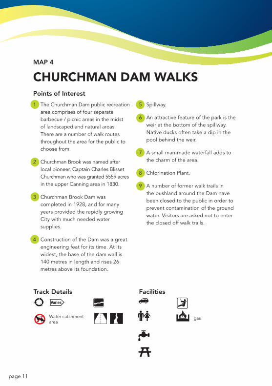
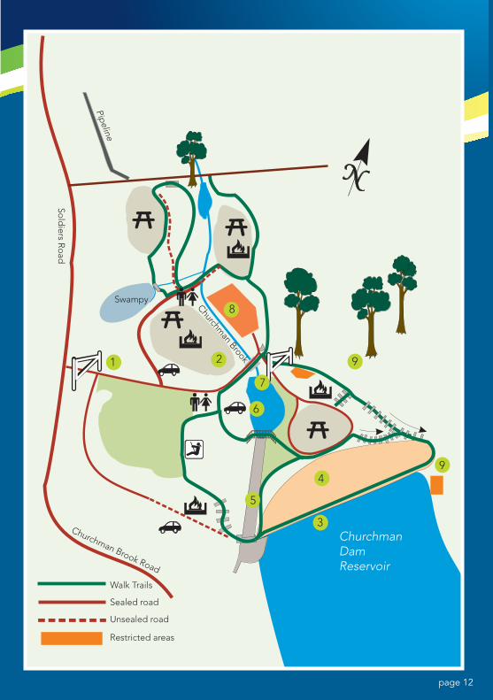
MAP 4
CHURCHMAN DAM WALKSPoints of Interest
1 TheChurchmanDampublicrecreationarea comprises of four separate barbecue / picnic areas in the midst of landscaped and natural areas. Thereareanumberofwalkroutesthroughout the area for the public to choose from.
2 ChurchmanBrookwasnamedafterlocalpioneer,CaptainCharlesBlissetChurchmanwhowasgranted5559acresintheupperCanningareain1830.
3 ChurchmanBrookDamwascompletedin1928,andformanyyearsprovidedtherapidlygrowingCitywithmuchneededwatersupplies.
4 ConstructionoftheDamwasagreatengineeringfeatforitstime.Atitswidest,thebaseofthedamwallis140 metres in length and rises 26 metresaboveitsfoundation.
5 Spillway.
6 Anattractivefeatureoftheparkistheweir at the bottom of the spillway. Nativeducksoftentakeadipinthepool behind the weir.
7 Asmallman-madewaterfalladdstothe charm of the area.
8 ChlorinationPlant.
9 AnumberofformerwalktrailsinthebushlandaroundtheDamhavebeen closed to the public in order to preventcontaminationofthegroundwater.Visitorsareaskednottoenterthe closed off walk trails.
Water catchmentarea
gas
Track Details Facilities
Water catchmentarea
gas
Track Details Facilities
page 12
9
94
3
5
6
7
21
8Swampy
ChurchmanDam Reservoir
Walk Trails
Sealed road
Unsealed road
Restricted areas
Churchman Brook Road
Churchman Brook
Sold
iers Ro
ad
Pipeline
page 13
MAP 5
SETTLERS COMMON WALK TRAILSPoints of Interest
1 ArmadaleSettlersCommonwasgazettedbytheColonyofWAin1897 as commonage and timber sourceforthelocalsettlers.TheCommonhasbeenmanagedbyagroupofdedicatedvolunteerssince1988.
2 TheFieldStudyCentreisthefocuspointofanumberofenvironmentaleducationactivitiesandishometoseveralconservationorganisations.
3 One of a number of points around theCommonwherewalkerscantakeadvantageofbreathtakingviews.
4 LightningTree.In1991,thisgrandold tree was struck by lightning andsplitintwo.Atestamenttothesurvivalmechanismsofournativebush,thetwotreehalvesarenowthrivingontheirsides.
5 CapRockCountry.AlongthisstretchofSettlersRoadthevegetationislessthan 50 centimeters tall and differs
fromotherareasintheCommon.Thisareahasfewtrees,notbecauseithasbeencleared,butbecausethesoilissoshallow.Lookoutforthemanysundews and other small flowers growing here.
6 YongaView.Expansiveviewstothenorth along the edge of the scarp andwestoverthecoastalplainincluding the city.
7 TheGreatAmphitheatre.Atthestartofthewintercreek,thisnaturalamphitheatre is a mass of constantly changingcolouroverspring.Thisarea contains a great number of wildflowers and is a sight not to be missed.
8 ArmadaleSettlersCommonlogofeaturesawesternspinebill(CityofArmadaIe’sfaunaemblem)andgrevilleawilsonii-bothofwhicharefoundintheCommon.
(BrettTizard)
Paint marks onrocks along route gas
Track Details Facilities
Paint marks onrocks along route gas
Track Details Facilities
page 14
Lookout
ArmadaleSchool
Wheelchair access
Walk Trails
Sealed road
Unsealed road
Armadale Settlers Common
Good wildflower viewing
0 500mWaterwheel Road
Field Study CentreWinter Creek
Triton Close C
arradine
Road
Road
Settlers Road
Albany Highway
Canns
Observation Circle
54
7
8
3
1
2
6
page 15
MAP 6
HERITAGE TREE TRAILPoints of Interest
1 SugarGum.Australiannative.
Planted c. 1910.
2 FloodedGum.Foundthroughoutthe
foothills.
3 MoretonBayFig.Subtropical
species.Plantedin1890s.Heritage
listed
4 Oak.Internationalspecies.Planted
in1890s.ClassifiedbytheNational
Trust.
5 CarobTree.Itisthelastremaining
tree on the site of an original citrus
orchard. c 1900
6 QueenslandBox.Eastcoastnative.
Thegrovewasplantedin1921in
remembranceofArmadaleWWI
servicemenkilledinaction.
7 FanPalm.Internationalspecies.
Planted 1920s
8 PortJacksonFig.Australiannative.
Part of original gardens of Martin
Jullresidencec1895-1910.
9 SugarGum.Australiannative.
PlantedbyMartinJull1895-1910.
10 CanaryIslandPalm.Transplantedin
1987. Originally planted at residence
onSouthWesternHighway1952.
11 Poplar.Internationalspecies.These
are part of remaining trees from a
nursery. Planted 1960s.
12 Wandoo/WhiteGum.Thisspecies
islocatedthroughouttheDarling
ScarpandtotheeastofArmadale.
One of the original species felled for
timber in the area.
13 Jarrah.Thisheritagelistedtreeis
believedtobeover500yearsold.
Itgrowsonthesiteoftheoriginal
ArmadalePrimarySchool.
Tree 11 to Tree 20
Plaque ateach tree
Minnawarra ParkLions Park
Minnawarra ParkLions Park
Lions Park - wood
Minnawarra Park
Lions Park, Memorial Park
Track Details Facilities
page 16
Steep
FourthRoad
Brookside Arm
adale
Shopping City
Private property
Heritage TrailRail lineSealed road
Railway Avenue
Commerce
AvenueArmadale Train Station
Green AvenueForr
est A
venu
e
ArmadaleDistrict Hall
Church A
venue
Jull
Stre
et
Lions Park
Armad
ale
Road
Orchard Avenue
Alb
any
Hig
hway
11
10
9
8
5
6
7
12
134
Arm
adale Central
Shopping Centre
1
3
Olde Narrogin Inne
2
South Western Highway
page 17
MAP 7
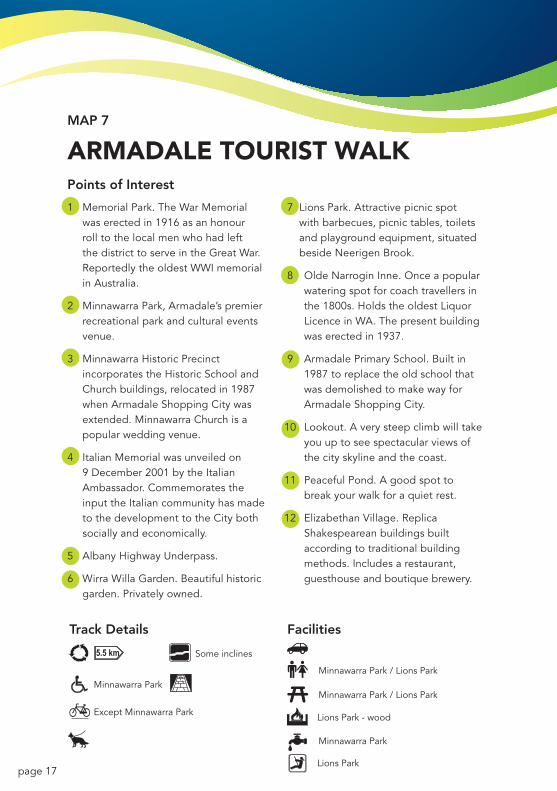
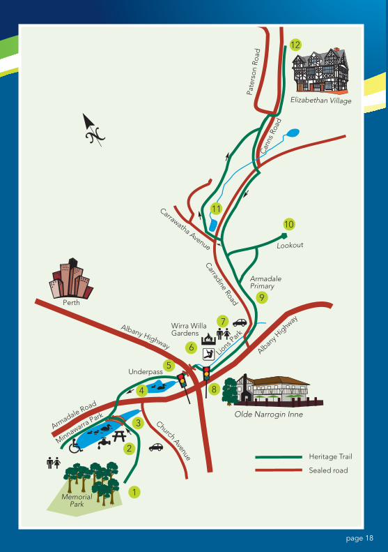
ARMADALE TOURIST WALKPoints of Interest
1 MemorialPark.TheWarMemorialwas erected in 1916 as an honour roll to the local men who had left thedistricttoserveintheGreatWar.ReportedlytheoldestWWImemorialinAustralia.
2 MinnawarraPark,Armadale’spremierrecreationalparkandculturaleventsvenue.
3 MinnawarraHistoricPrecinctincorporatestheHistoricSchoolandChurchbuildings,relocatedin1987whenArmadaleShoppingCitywasextended.MinnawarraChurchisapopularweddingvenue.
4 ItalianMemorialwasunveiledon9December2001bytheItalianAmbassador.CommemoratestheinputtheItaliancommunityhasmadetothedevelopmenttotheCitybothsocially and economically.
5 AlbanyHighwayUnderpass.
6 WirraWillaGarden.Beautifulhistoricgarden.Privatelyowned.
7 LionsPark.Attractivepicnicspotwithbarbecues,picnictables,toiletsandplaygroundequipment,situatedbesideNeerigenBrook.
8 OldeNarroginInne.Onceapopularwateringspotforcoachtravellersinthe1800s.HoldstheoldestLiquorLicenceinWA.Thepresentbuildingwas erected in 1937.
9 ArmadalePrimarySchool.Builtin1987 to replace the old school that was demolished to make way for ArmadaleShoppingCity.
10 Lookout.Averysteepclimbwilltakeyouuptoseespectacularviewsofthe city skyline and the coast.
11 PeacefulPond.Agoodspottobreak your walk for a quiet rest.
12 ElizabethanVillage.ReplicaShakespeareanbuildingsbuiltaccording to traditional building methods.Includesarestaurant,guesthouse and boutique brewery.
Minnawarra Park / Lions Park
Some inclines
Except Minnawarra Park
Minnawarra ParkMinnawarra Park / Lions Park
Minnawarra Park
Lions Park - wood
Lions Park
Track Details Facilities
page 18
Pate
rson
Roa
d
Elizabethan Village
Can
ns R
oad
1
2
3
4
6
7
8
9
10
12
11
Carradine Road
Lookout
ArmadalePrimary
Wirra WillaGardens
Underpass
Olde Narrogin Inne
Heritage Trail
Sealed road
Perth
MemorialPark
Albany H
ighway
Lions P
ark
Church Avenue
Albany Highway
Armadale Road
Minnawarra Park
5
Carrawatha Avenue
page 19
MAP 8
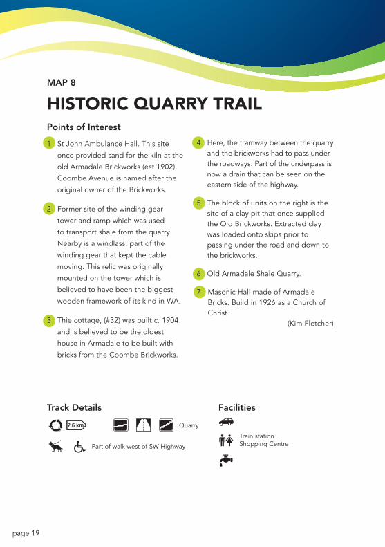
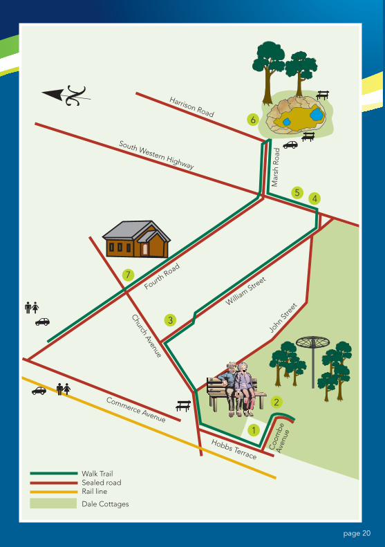
HISTORIC QUARRy TRAILPoints of Interest
1 StJohnAmbulanceHall.Thissite
onceprovidedsandforthekilnatthe
oldArmadaleBrickworks(est1902).
CoombeAvenueisnamedafterthe
originalowneroftheBrickworks.
2 Former site of the winding gear
tower and ramp which was used
to transport shale from the quarry.
Nearbyisawindlass,partofthe
winding gear that kept the cable
moving.Thisrelicwasoriginally
mounted on the tower which is
believedtohavebeenthebiggest
woodenframeworkofitskindinWA.
3 Thiecottage,(#32)wasbuiltc.1904
andisbelievedtobetheoldest
houseinArmadaletobebuiltwith
bricksfromtheCoombeBrickworks.
4 Here,thetramwaybetweenthequarryand the brickworks had to pass under the roadways. Part of the underpass is now a drain that can be seen on the eastern side of the highway.
5 Theblockofunitsontherightisthesite of a clay pit that once supplied theOldBrickworks.Extractedclaywas loaded onto skips prior to passing under the road and down to the brickworks.
6 OldArmadaleShaleQuarry.
7 MasonicHallmadeofArmadaleBricks.Buildin1926asaChurchofChrist.
(KimFletcher)
Part of walk west of SW Highway
Quarry
Train stationShopping Centre
Track Details Facilities
page 20
1
2
3
45
6
Walk TrailSealed roadRail line
Dale Cottages
Harrison Road
South Western Highway
Mar
sh R
oad
Fourth Road
William Stre
etJo
hn S
treet
Church Avenue
Hobbs Terrace
Commerce Avenue
Coo
mbe
Ave
nue
7
page 21
MAP 9
fORRESTDALE TRAILPoints of Interest
1 TheareawaspreviouslyknownasEastJandakot but was renamed Forrestdale inApril1915.Thelakeretainedthename Jandakot until March 1974 when itwasalsorenamedForrestdaleLakelistedundertheRamsarConventionasaWetlandofInternationalImportanceformigratory water birds.
2 Theoriginalboardwalkwasconstructedin1994butwasdestroyedbyfire.Thenew structure was completed in 2011.
3 AlfredandWilliamSkeetParkwasnamed after the pioneers to take up Forrestdale land in 1885.
4 WaterreedsandnestingbirdsattractTigerSnakes.Becareful,especiallyifyouleavetheTrail.
5 ThisplaquecommemoratesThe Forrestdale Trail,Stage1wasofficiallyopenedon15March1998.Stage2(alongtheeasternsideofthelake)wasconstructed in 2000.
6 HighpointwithexcellentviewsoftheLake.
7 ThisdrainwasexcavatedbythePWDinapproximately1910,andwasoriginally lined with railway sleepers. ItonlydrainstheLakewhenthewaterlevelexceedstwometres-Thelasttime the lake was drained was in the 1960’s.
8 DuringWWIIfuelwasmovedfromFremantleandstoredindrums,wellcamouflaged in the banksia woodland area in case the enemy bombed the PortCity.
9 ArmadalePublicGolfCourse,nineholes. Opened in 1977.
10 Thissectionofcyclepathwayfollows the same route as the former ArmadaletoFremantlerailline(1907-1963).
Stirling Road
East side of lake
Forrest Road to Swamp Road
Sealed Forrest Rd to Swamp Rdremainder - limestone track
Weld Street
Skeet Oval
Weld Street, William Skeet Oval,Golf Course
William Skeet OvalBridle path only
Track Details Facilities
Stirling Road
East side of lake
Forrest Road to Swamp Road
Sealed Forrest Rd to Swamp Rdremainder - limestone track
Weld Street
Skeet Oval
Weld Street, William Skeet Oval,Golf Course
William Skeet OvalBridle path only
Track Details Facilities
page 22
9
67
8
32
4
10
1
5
Armadale Golf Course
ForrestdalePrimaryNapier StreetForre
st Road
Arm
adal
e R
oad
Stirling Road
Oxl
ey R
oad
Oxl
ey R
oad
Dense HeathSwampy Health
Moore Street
WeldStreet
Horse trackto Rowley Road
Area underrehabilitation
Walk TrailConcrete cycle/Wheelchair path
Bridle PathSealed roadUnSealed roadService
Station
Nicholson Road
BollardGate
ForrestdaleLake
BoardwalkGate
Gate
Swampunder water in winter
Swam
p R
oad
Lake
Ro
ad Commercial Road
Tonkin Highway
Bro
om
e St
reet
page 23
MAP 10
BUNGENDORE PARK TRAILSPoints of Interest
1 BungendoreParkwasdeclaredin 1897 and originally gazetted fortimber.TheparkisanAClassReserve,managedasaconservationreservewithlowimpactusage. InJune1981acommitteeofcommunityvolunteerswasestablished to manage and protect the Park.
2 Walkerscanoftenseegroupsofgreykangaroos grazing on the school oval.
3 ApopularnestingandcongregationareaoftheRed-tailedBlackCockatoo.
4 Inspring,arangeoforchidsgrowinthisarea.Keepaneyeoutforthefamilyofblack-glovedwallabiesthatreside around here.
5 GravelextractionandtracksthroughtheParkleftseveralareasdenuded.TheManagementCommitteehasbeeninvolvedinrevegetationsince1982,resultinginmanyareasbeingreplantedwithvegetationnativetothe area.
6 LookforWesternSpinebillsandNewHollandHoneyeaterssearchingfornectarinParrotBushandGrevilleaBush.
7 PanoramicviewstothecoastandCity.
8 Lowlyinglandinheavyshadepromotes the prolific growth of bracken fern.
9 TheBungendoreParklogofeaturestheblossomandseedcapsule(honkynuts)oftheMarritree.
*Whistler Walk
*Robin Ramble
*Spinebill Stroll
*Honeyeater Hike
Coloured markers attached to trees
Designated bridle trails only (7km)
*Distance measuredfrom Admiral Roadstart point
Track Details Facilities
*Whistler Walk
*Robin Ramble
*Spinebill Stroll
*Honeyeater Hike
Coloured markers attached to trees
Designated bridle trails only (7km)
*Distance measuredfrom Admiral Roadstart point
Track Details Facilities
page 24
Albany Highway
9
7 5
8
7
6
5
2
1
3
4
3
To White RailsBridle Trail
WaterTower Red Gum
Loop
Armadale Settlers Common
2.km(see Map 5)
Howe Street
ArmadaleChristian College
Wattle Road
Nelso
n Street
Adm
iral Road
Cooliabberra Spring Dryandra Drive
Casuarina Road
Dryand
ra Drive
Walk Trails
Bridle Trail
Sealed road
Honeyeater Hike
Robin Ramble
Spinebill Stroll
Whistler Walk
Rehabilitation area
Designated Walks
Waterwheel Road
page 25
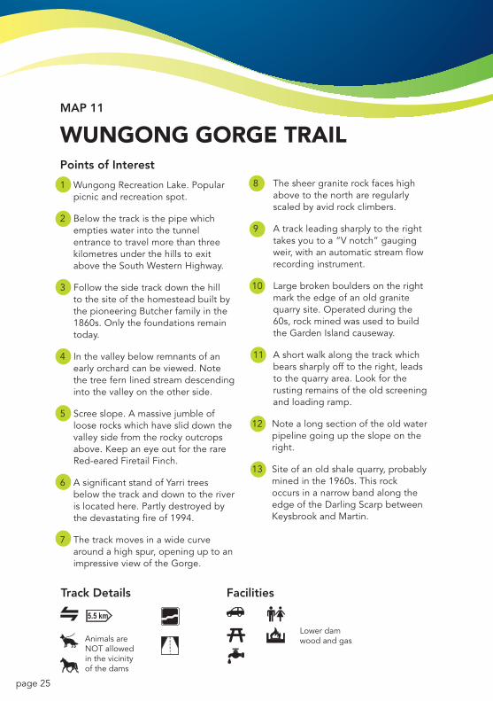
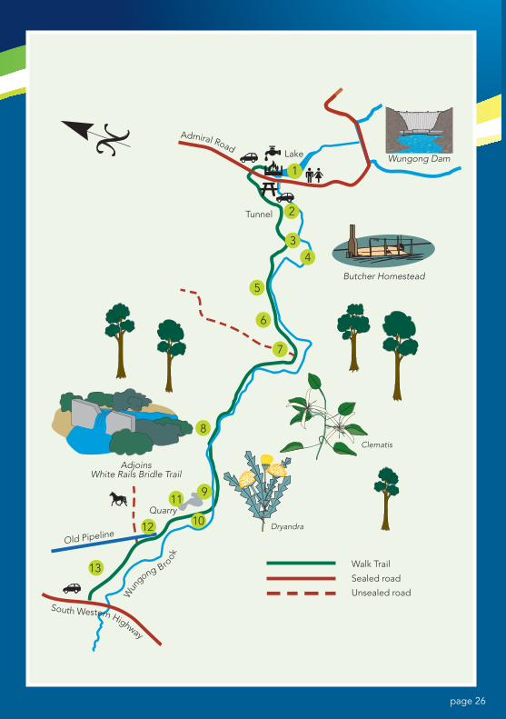
MAP 11
WUNGONG GORGE TRAILPoints of Interest
1 WungongRecreationLake.Popularpicnic and recreation spot.
2 Belowthetrackisthepipewhichempties water into the tunnel entrancetotravelmorethanthreekilometresunderthehillstoexitabovetheSouthWesternHighway.
3 Follow the side track down the hill to the site of the homestead built by thepioneeringButcherfamilyinthe1860s. Only the foundations remain today.
4 Inthevalleybelowremnantsofanearlyorchardcanbeviewed.Notethe tree fern lined stream descending intothevalleyontheotherside.
5 Screeslope.Amassivejumbleoflooserockswhichhavesliddownthevalleysidefromtherockyoutcropsabove.KeepaneyeoutfortherareRed-earedFiretailFinch.
6 AsignificantstandofYarritreesbelowthetrackanddowntotheriveris located here. Partly destroyed by thedevastatingfireof1994.
7 Thetrackmovesinawidecurvearoundahighspur,openinguptoanimpressiveviewoftheGorge.
8 Thesheergraniterockfaceshighabovetothenorthareregularlyscaledbyavidrockclimbers.
9 Atrackleadingsharplytotherighttakesyoutoa“Vnotch”gaugingweir,withanautomaticstreamflowrecording instrument.
10 Largebrokenbouldersontherightmark the edge of an old granite quarry site. Operated during the 60s,rockminedwasusedtobuildtheGardenIslandcauseway.
11 Ashortwalkalongthetrackwhichbearssharplyofftotheright,leadstothequarryarea.Lookfortherusting remains of the old screening and loading ramp.
12 Note a long section of the old water pipeline going up the slope on the right.
13 Siteofanoldshalequarry,probablyminedinthe1960s.Thisrockoccurs in a narrow band along the edgeoftheDarlingScarpbetweenKeysbrookandMartin.
Animals areNOT allowedin the vicinity of the dams
Lower damwood and gas
Track Details Facilities
page 26
8
4
1
9
10
11
12
13
Lake Wungong Dam
Butcher Homestead
Sealed road
Quarry
AdjoinsWhite Rails Bridle Trail
Old Pipeline
Unsealed road
Walk Trail
Admiral Road
Wun
gong Brook
South Western Highway
2Tunnel
3
5
7
6
Dryandra
Clematis