Embed Size (px)
Citation preview

459
40Ar/39Ar ages of silicic volcanic rocks in the Tauranga-Kaimai area, New Zealand: dating the transition between volcanism in the Coromandel Arc and the Taupo Volcanic Zone
G04014; Online publication date 22 August 2005 Received 19 March 2004; accepted 8 February 2005
New Zealand Journal of Geology & Geophysics, 2005, Vol. 48: 459–4690028–8306/05/4803–0459 © The Royal Society of New Zealand 2005
R. M. BRIGGSDepartment of Earth SciencesUniversity of WaikatoPrivate Bag 3105Hamilton, New ZealandB. F. HOUGHTON*
Institute of Geological & Nuclear SciencesWairakei Research CentrePrivate Bag 2000Taupo, New ZealandM. MCWILLIAMSDepartment of Geological and Environmental SciencesStanford UniversityStanford, California 94305-2115, USAC. J. N. WILSON†
Institute of Geological & Nuclear SciencesGracefield Research CentreP.O. Box 30368Lower Hutt, New Zealand*Present address: Department of Geology and Geophysics, SOEST, University of Hawaii at Manoa, Honolulu, Hawaii 96822.†Department of Geology, University of Auckland, Private Bag 92 019, Auckland.
Abstract Subduction-related volcanism in the northern part of the North Island of New Zealand shifted abruptly during the late Pliocene. This study focuses on the transition, in time and space, from the NNW-oriented Miocene–Pliocene Coromandel Volcanic Zone to the northeast-oriented active Taupo Volcanic Zone. The volcanic rocks marking this transition are exposed in the Tauranga Basin and adjacent Kaimai Range, and associated here with the recently defined Tauranga and Kaimai Volcanic Centres, respectively. New 40Ar/39Ar age determinations indicate that the transition occurred between 1.90 and 1.55 Ma, that is between the youngest age of silicic volcanism in the Tauranga-Kaimai area, and the age of the oldest silicic volcanism in the Taupo Volcanic Zone. This interpretation is generally consistent with recent plate models and with the initiation of the Kermadec Arc within the last 2 m.y.
Keywords 40Ar/39Ar; silicic volcanism; Tauranga Volcanic Centre; Kaimai Volcanic Centre; Pliocene; Pleistocene; Aongatete Ignimbrites; Waiteariki Ignimbrite; Papamoa ignimbrites; Hauraki Fault
INTRODUCTION
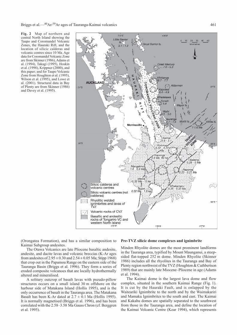
Volcanic rocks exposed in the Tauranga area and Kaimai Range represent an important geographical and chronological transition from the Miocene–Pliocene Coromandel Volcanic Zone (CVZ) to the Pleistocene–Recent Taupo Volcanic Zone (TVZ) (Fig. 1). The Tauranga-Kaimai area contains at least 21 dacite-rhyolite domes or dome complexes together with 3 defined ignimbrite formations that are inferred to predate the onset of TVZ volcanism. The topographically higher domes and flows of the Tauranga-Kaimai area are in part covered and encircled by the younger, voluminous, and partially welded ignimbrites derived from the Rotorua Volcanic Centre in the TVZ to the south.
Previously available radiometric ages (see discussion below) from rocks of the Tauranga-Kaimai area were inadequate to constrain the transition between the two volcanic zones. Here, we present new 40Ar/39Ar age data on the volcanic rocks of the Tauranga-Kaimai area, in an attempt to date the transition between volcanism in the Coromandel Arc and that in the TVZ. We use these new data to constrain the timing of major displacement on the Hauraki Fault, which defines the eastern margin of the Hauraki Rift, and discuss some preliminary geochemical, mineralogical, and spatial relations of rhyolitic and dacitic volcanics within what are defined in Kear (1994) and here as the Tauranga and Kaimai Volcanic Centres.
VOLCANIC GEOLOGY AND PREVIOUS CHRONOLOGY OF THE TAURANGA-KAIMAI AREA
The Tauranga-Kaimai area includes a Pliocene subaerial volcanic sequence that forms the southern Kaimai Ranges, a series of late Pliocene rhyolite domes that form characteristic landforms, extensive tilted and gently dipping plateaus of late Pliocene–Quaternary ignimbrites, and Quaternary volcaniclastic sediments that largely infill the Tauranga Basin (Fig. 1) (Briggs et al. 1996). The central part of the modern Tauranga Basin is occupied by Tauranga Harbour, a large shallow estuary with a northern and southern entrance confined by tombolos and the barrier island complex of Matakana Island. The whole region is generally blanketed by a thick cover of late Pleistocene–Recent silicic tephras derived from the TVZ and Mayor Island Volcanic Centre. The sequence is summarised below in stratigraphic order (see Briggs et al. 1996).
Late Miocene–Pliocene andesite-dacite cone volcanism
The oldest rocks in the Tauranga-Kaimai area are andesitic to dacitic lavas, dikes, and volcaniclastic strata of the Kaimai Subgroup (defined by Houghton & Cuthbertson 1989), which are exposed in the uplifted Kaimai Range. Brathwaite & Christie (1996) presented 18 K-Ar ages (whole

460 New Zealand Journal of Geology and Geophysics, 2005, Vol. 48
rock, biotite, hornblende) from Kaimai Subgroup andesites and dacites in the Waihi district north of the Tauranga area, which range in age from 4.01 ± 0.09 to 5.56 ± 0.35 Ma. The Kaimai Subgroup rocks are overlain by the Aongatete Ignimbrites that crop out on the eastern side of the Kaimai Range. The Aongatete Ignimbrites consist of a >290 m sequence of non-welded to densely welded lenticular dacitic ignimbrites and tuffs, with evidence
(paleosols, intercalated sediments) for their having been erupted over a prolonged period of time (Houghton & Cuthbertson 1989).
Motiti Island is situated 12 km offshore from the Bay of Plenty coast northeast of Tauranga (Fig. 2), and is a flat-lying eroded remnant of a Pliocene andesitic composite cone. It has been K-Ar (whole rock) dated by Itaya (in Henry 1991) at 4.32 ± 0.68 (Motiti Formation) and 3.42 ± 0.19 Ma
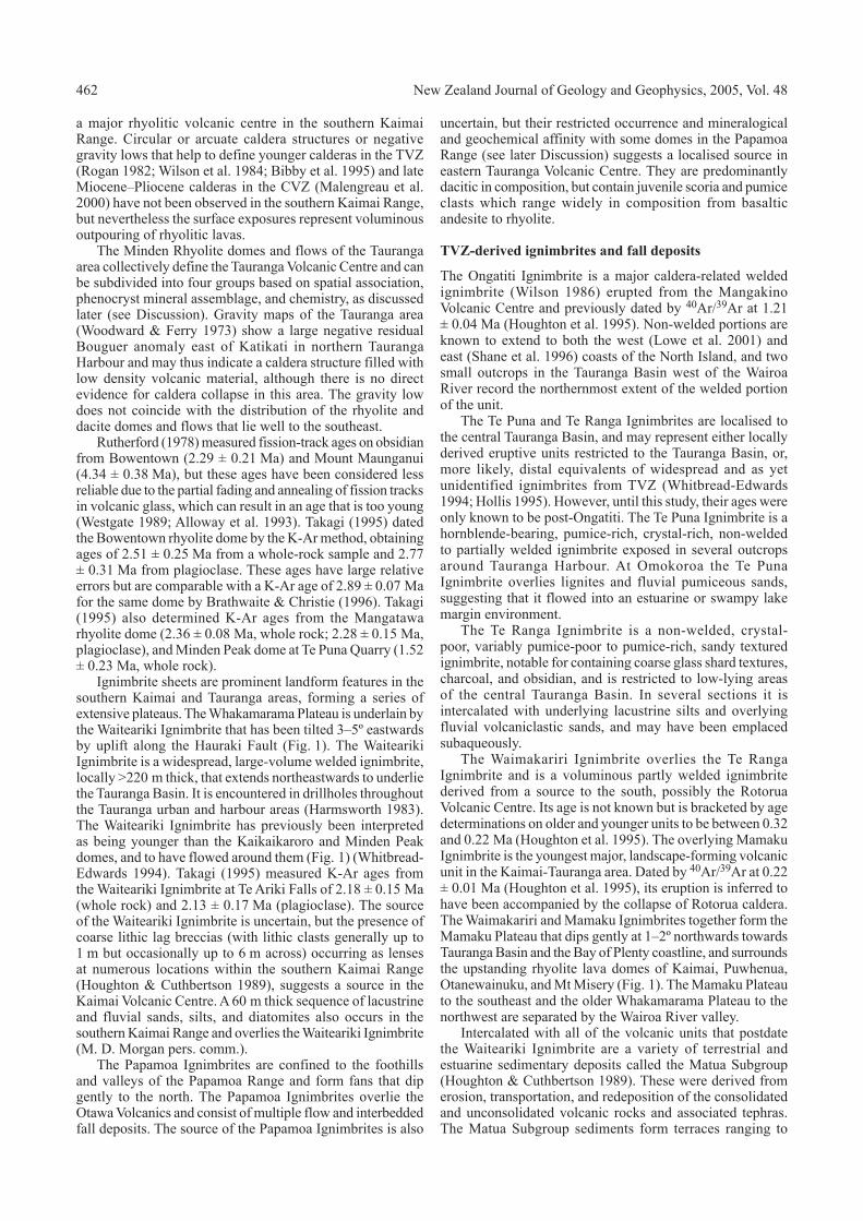
Fig. 1 Geological map of Tauranga and southern Kaimai Range showing the distribution of rhyolite and dacite domes and their 40Ar/39Ar ages. Whole-rock K-Ar ages determined by previous authors are given in brackets: ( ) = Takagi (1995); { } = Brathwaite & Christie (1996); p = K-Ar age from plagioclase. Inset: Location of the Coromandel and Taupo Volcanic Zones in the North Island, New Zealand. The Tauranga-Kaimai area is indicated by the box.
461 Briggs et al.—40Ar/39Ar ages of Tauranga-Kaimai volcanics
(Orongatea Formation), and has a similar composition to Kaimai Subgroup andesites.
The Otawa Volcanics are late Pliocene basaltic andesite, andesite, and dacite lavas and volcanic breccias (K-Ar ages from andesites of 2.95 ± 0.30 and 2.54 ± 0.05 Ma; Stipp 1968) that crop out in the Papamoa Range on the eastern side of the Tauranga Basin (Briggs et al. 1996). They form a series of eroded composite volcanoes that are locally hydrothermally altered and mineralised.
A solitary outcrop of basalt lavas with pseudo-pillow structures occurs on a small island 30 m offshore on the harbour side of Matakana Island (Hollis 1995), and is the only occurrence of basalt in the Tauranga area. The Matakana Basalt has been K-Ar dated at 2.7 ± 0.1 Ma (Hollis 1995). It is normally magnetised (Briggs et al. 1996), and has been correlated with the 2.58–3.58 Ma Gauss Chron (cf. Berggren et al. 1995).
Pre-TVZ silicic dome complexes and ignimbrite
Minden Rhyolite domes are the most prominent landforms in the Tauranga area, typified by Mount Maunganui, a steep-sided flat-topped 252 m dome. Minden Rhyolite (Skinner 1986) includes all the rhyolites in the Tauranga and Bay of Plenty region northwest of the TVZ (Houghton & Cuthbertson 1989) that are mainly late Miocene–Pliocene in age (Adams et al. 1994).
The Kaimai dome is the largest lava dome and flow complex, situated in the southern Kaimai Range (Fig. 1). It is cut by the Hauraki Fault, and is onlapped by the Waiteariki Ignimbrite to the north and by the Waimakariri and Mamaku Ignimbrites to the south and east. The Kaimai and Kakahu domes are spatially separated to the southwest from those in the Tauranga area, and define the location of the Kaimai Volcanic Centre (Kear 1994), which represents
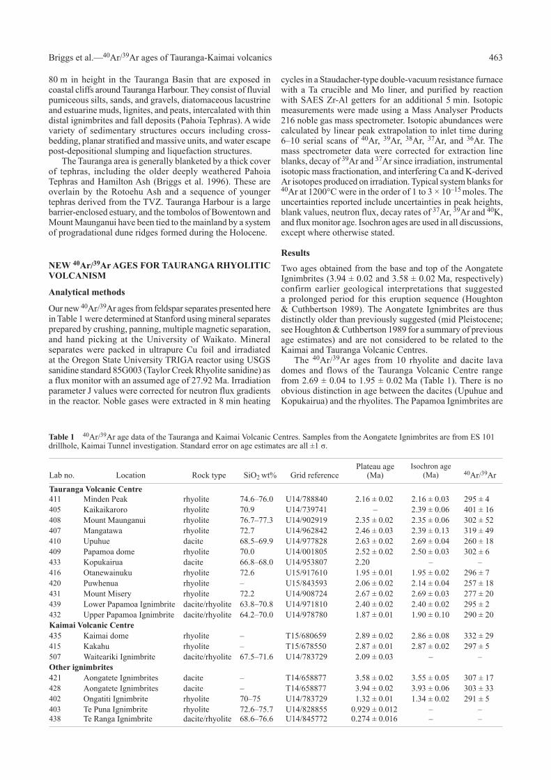
Fig. 2 Map of northern and central North Island showing the Taupo and Coromandel Volcanic Zones, the Hauraki Rift, and the location of silicic calderas and volcanic centres since 10 Ma. Age data for Coromandel Volcanic Zone are from Skinner (1986), Adams et al. (1994), Takagi (1995), Hoskin et al. (1998), Krippner (2000), and this paper; and for Taupo Volcanic Zone from Houghton et al. (1995), Wilson et al. (1995), and Lowe et al. (2001). Structural data in Bay of Plenty are from Skinner (1986) and Davey et al. (1995).
462 New Zealand Journal of Geology and Geophysics, 2005, Vol. 48
a major rhyolitic volcanic centre in the southern Kaimai Range. Circular or arcuate caldera structures or negative gravity lows that help to define younger calderas in the TVZ (Rogan 1982; Wilson et al. 1984; Bibby et al. 1995) and late Miocene–Pliocene calderas in the CVZ (Malengreau et al. 2000) have not been observed in the southern Kaimai Range, but nevertheless the surface exposures represent voluminous outpouring of rhyolitic lavas.
The Minden Rhyolite domes and flows of the Tauranga area collectively define the Tauranga Volcanic Centre and can be subdivided into four groups based on spatial association, phenocryst mineral assemblage, and chemistry, as discussed later (see Discussion). Gravity maps of the Tauranga area (Woodward & Ferry 1973) show a large negative residual Bouguer anomaly east of Katikati in northern Tauranga Harbour and may thus indicate a caldera structure filled with low density volcanic material, although there is no direct evidence for caldera collapse in this area. The gravity low does not coincide with the distribution of the rhyolite and dacite domes and flows that lie well to the southeast.
Rutherford (1978) measured fission-track ages on obsidian from Bowentown (2.29 ± 0.21 Ma) and Mount Maunganui (4.34 ± 0.38 Ma), but these ages have been considered less reliable due to the partial fading and annealing of fission tracks in volcanic glass, which can result in an age that is too young (Westgate 1989; Alloway et al. 1993). Takagi (1995) dated the Bowentown rhyolite dome by the K-Ar method, obtaining ages of 2.51 ± 0.25 Ma from a whole-rock sample and 2.77 ± 0.31 Ma from plagioclase. These ages have large relative errors but are comparable with a K-Ar age of 2.89 ± 0.07 Ma for the same dome by Brathwaite & Christie (1996). Takagi (1995) also determined K-Ar ages from the Mangatawa rhyolite dome (2.36 ± 0.08 Ma, whole rock; 2.28 ± 0.15 Ma, plagioclase), and Minden Peak dome at Te Puna Quarry (1.52 ± 0.23 Ma, whole rock).
Ignimbrite sheets are prominent landform features in the southern Kaimai and Tauranga areas, forming a series of extensive plateaus. The Whakamarama Plateau is underlain by the Waiteariki Ignimbrite that has been tilted 3–5º eastwards by uplift along the Hauraki Fault (Fig. 1). The Waiteariki Ignimbrite is a widespread, large-volume welded ignimbrite, locally >220 m thick, that extends northeastwards to underlie the Tauranga Basin. It is encountered in drillholes throughout the Tauranga urban and harbour areas (Harmsworth 1983). The Waiteariki Ignimbrite has previously been interpreted as being younger than the Kaikaikaroro and Minden Peak domes, and to have flowed around them (Fig. 1) (Whitbread-Edwards 1994). Takagi (1995) measured K-Ar ages from the Waiteariki Ignimbrite at Te Ariki Falls of 2.18 ± 0.15 Ma (whole rock) and 2.13 ± 0.17 Ma (plagioclase). The source of the Waiteariki Ignimbrite is uncertain, but the presence of coarse lithic lag breccias (with lithic clasts generally up to 1 m but occasionally up to 6 m across) occurring as lenses at numerous locations within the southern Kaimai Range (Houghton & Cuthbertson 1989), suggests a source in the Kaimai Volcanic Centre. A 60 m thick sequence of lacustrine and fluvial sands, silts, and diatomites also occurs in the southern Kaimai Range and overlies the Waiteariki Ignimbrite (M. D. Morgan pers. comm.).
The Papamoa Ignimbrites are confined to the foothills and valleys of the Papamoa Range and form fans that dip gently to the north. The Papamoa Ignimbrites overlie the Otawa Volcanics and consist of multiple flow and interbedded fall deposits. The source of the Papamoa Ignimbrites is also
uncertain, but their restricted occurrence and mineralogical and geochemical affinity with some domes in the Papamoa Range (see later Discussion) suggests a localised source in eastern Tauranga Volcanic Centre. They are predominantly dacitic in composition, but contain juvenile scoria and pumice clasts which range widely in composition from basaltic andesite to rhyolite.
TVZ-derived ignimbrites and fall deposits
The Ongatiti Ignimbrite is a major caldera-related welded ignimbrite (Wilson 1986) erupted from the Mangakino Volcanic Centre and previously dated by 40Ar/39Ar at 1.21 ± 0.04 Ma (Houghton et al. 1995). Non-welded portions are known to extend to both the west (Lowe et al. 2001) and east (Shane et al. 1996) coasts of the North Island, and two small outcrops in the Tauranga Basin west of the Wairoa River record the northernmost extent of the welded portion of the unit.
The Te Puna and Te Ranga Ignimbrites are localised to the central Tauranga Basin, and may represent either locally derived eruptive units restricted to the Tauranga Basin, or, more likely, distal equivalents of widespread and as yet unidentified ignimbrites from TVZ (Whitbread-Edwards 1994; Hollis 1995). However, until this study, their ages were only known to be post-Ongatiti. The Te Puna Ignimbrite is a hornblende-bearing, pumice-rich, crystal-rich, non-welded to partially welded ignimbrite exposed in several outcrops around Tauranga Harbour. At Omokoroa the Te Puna Ignimbrite overlies lignites and fluvial pumiceous sands, suggesting that it flowed into an estuarine or swampy lake margin environment.
The Te Ranga Ignimbrite is a non-welded, crystal-poor, variably pumice-poor to pumice-rich, sandy textured ignimbrite, notable for containing coarse glass shard textures, charcoal, and obsidian, and is restricted to low-lying areas of the central Tauranga Basin. In several sections it is intercalated with underlying lacustrine silts and overlying fluvial volcaniclastic sands, and may have been emplaced subaqueously.
The Waimakariri Ignimbrite overlies the Te Ranga Ignimbrite and is a voluminous partly welded ignimbrite derived from a source to the south, possibly the Rotorua Volcanic Centre. Its age is not known but is bracketed by age determinations on older and younger units to be between 0.32 and 0.22 Ma (Houghton et al. 1995). The overlying Mamaku Ignimbrite is the youngest major, landscape-forming volcanic unit in the Kaimai-Tauranga area. Dated by 40Ar/39Ar at 0.22 ± 0.01 Ma (Houghton et al. 1995), its eruption is inferred to have been accompanied by the collapse of Rotorua caldera. The Waimakariri and Mamaku Ignimbrites together form the Mamaku Plateau that dips gently at 1–2º northwards towards Tauranga Basin and the Bay of Plenty coastline, and surrounds the upstanding rhyolite lava domes of Kaimai, Puwhenua, Otanewainuku, and Mt Misery (Fig. 1). The Mamaku Plateau to the southeast and the older Whakamarama Plateau to the northwest are separated by the Wairoa River valley.
Intercalated with all of the volcanic units that postdate the Waiteariki Ignimbrite are a variety of terrestrial and estuarine sedimentary deposits called the Matua Subgroup (Houghton & Cuthbertson 1989). These were derived from erosion, transportation, and redeposition of the consolidated and unconsolidated volcanic rocks and associated tephras. The Matua Subgroup sediments form terraces ranging to
463 Briggs et al.—40Ar/39Ar ages of Tauranga-Kaimai volcanics
80 m in height in the Tauranga Basin that are exposed in coastal cliffs around Tauranga Harbour. They consist of fluvial pumiceous silts, sands, and gravels, diatomaceous lacustrine and estuarine muds, lignites, and peats, intercalated with thin distal ignimbrites and fall deposits (Pahoia Tephras). A wide variety of sedimentary structures occurs including cross-bedding, planar stratified and massive units, and water escape post-depositional slumping and liquefaction structures.
The Tauranga area is generally blanketed by a thick cover of tephras, including the older deeply weathered Pahoia Tephras and Hamilton Ash (Briggs et al. 1996). These are overlain by the Rotoehu Ash and a sequence of younger tephras derived from the TVZ. Tauranga Harbour is a large barrier-enclosed estuary, and the tombolos of Bowentown and Mount Maunganui have been tied to the mainland by a system of progradational dune ridges formed during the Holocene.
NEW 40Ar/39Ar AGES FOR TAURANGA RHYOLITIC VOLCANISM
Analytical methods
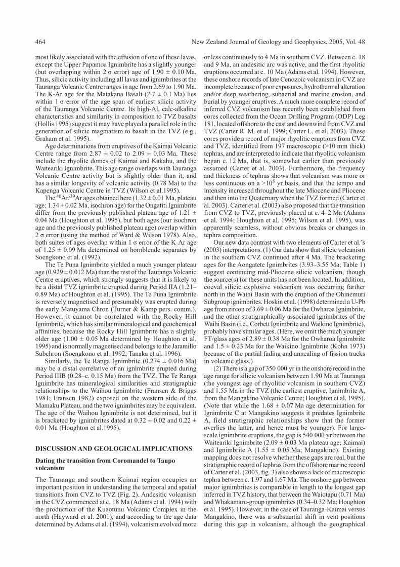
Our new 40Ar/39Ar ages from feldspar separates presented here in Table 1 were determined at Stanford using mineral separates prepared by crushing, panning, multiple magnetic separation, and hand picking at the University of Waikato. Mineral separates were packed in ultrapure Cu foil and irradiated at the Oregon State University TRIGA reactor using USGS sanidine standard 85G003 (Taylor Creek Rhyolite sanidine) as a flux monitor with an assumed age of 27.92 Ma. Irradiation parameter J values were corrected for neutron flux gradients in the reactor. Noble gases were extracted in 8 min heating
cycles in a Staudacher-type double-vacuum resistance furnace with a Ta crucible and Mo liner, and purified by reaction with SAES Zr-Al getters for an additional 5 min. Isotopic measurements were made using a Mass Analyser Products 216 noble gas mass spectrometer. Isotopic abundances were calculated by linear peak extrapolation to inlet time during 6–10 serial scans of 40Ar, 39Ar, 38Ar, 37Ar, and 36Ar. The mass spectrometer data were corrected for extraction line blanks, decay of 39Ar and 37Ar since irradiation, instrumental isotopic mass fractionation, and interfering Ca and K-derived Ar isotopes produced on irradiation. Typical system blanks for 40Ar at 1200°C were in the order of 1 to 3 × 10–15 moles. The uncertainties reported include uncertainties in peak heights, blank values, neutron flux, decay rates of 37Ar, 39Ar and 40K, and flux monitor age. Isochron ages are used in all discussions, except where otherwise stated.
Results
Two ages obtained from the base and top of the Aongatete Ignimbrites (3.94 ± 0.02 and 3.58 ± 0.02 Ma, respectively) confirm earlier geological interpretations that suggested a prolonged period for this eruption sequence (Houghton & Cuthbertson 1989). The Aongatete Ignimbrites are thus distinctly older than previously suggested (mid Pleistocene; see Houghton & Cuthbertson 1989 for a summary of previous age estimates) and are not considered to be related to the Kaimai and Tauranga Volcanic Centres.
The 40Ar/39Ar ages from 10 rhyolite and dacite lava domes and flows of the Tauranga Volcanic Centre range from 2.69 ± 0.04 to 1.95 ± 0.02 Ma (Table 1). There is no obvious distinction in age between the dacites (Upuhue and Kopukairua) and the rhyolites. The Papamoa Ignimbrites are
Lab no. Location Rock type SiO2 wt% Grid referencePlateau age
(Ma)Isochron age
(Ma) 40Ar/39Ar
Tauranga Volcanic Centre411 Minden Peak rhyolite 74.6–76.0 U14/788840 2.16 ± 0.02 2.16 ± 0.03 295 ± 4405 Kaikaikaroro rhyolite 70.9 U14/739741 – 2.39 ± 0.06 401 ± 16408 Mount Maunganui rhyolite 76.7–77.3 U14/902919 2.35 ± 0.02 2.35 ± 0.06 302 ± 52407 Mangatawa rhyolite 72.7 U14/962842 2.46 ± 0.03 2.39 ± 0.13 319 ± 49410 Upuhue dacite 68.5–69.9 U14/977828 2.63 ± 0.02 2.69 ± 0.04 260 ± 18409 Papamoa dome rhyolite 70.0 U14/001805 2.52 ± 0.02 2.50 ± 0.03 302 ± 6433 Kopukairua dacite 66.8–68.0 U14/953807 2.20 – –416 Otanewainuku rhyolite 72.6 U15/917610 1.95 ± 0.01 1.95 ± 0.02 296 ± 7420 Puwhenua rhyolite – U15/843593 2.06 ± 0.02 2.14 ± 0.04 257 ± 18431 Mount Misery rhyolite 72.2 U14/908724 2.67 ± 0.02 2.69 ± 0.03 277 ± 20439 Lower Papamoa Ignimbrite dacite/rhyolite 63.8–70.8 U14/971810 2.40 ± 0.02 2.40 ± 0.02 295 ± 2432 Upper Papamoa Ignimbrite dacite/rhyolite 64.2–70.0 U14/978780 1.87 ± 0.01 1.90 ± 0.10 290 ± 20Kaimai Volcanic Centre435 Kaimai dome rhyolite – T15/680659 2.89 ± 0.02 2.86 ± 0.08 332 ± 29415 Kakahu rhyolite – T15/678550 2.87 ± 0.01 2.87 ± 0.02 297 ± 5507 Waiteariki Ignimbrite dacite/rhyolite 67.5–71.6 U14/783729 2.09 ± 0.03 – –Other ignimbrites421 Aongatete Ignimbrites dacite – T14/658877 3.58 ± 0.02 3.55 ± 0.05 307 ± 17428 Aongatete Ignimbrites dacite – T14/658877 3.94 ± 0.02 3.93 ± 0.06 303 ± 33402 Ongatiti Ignimbrite rhyolite 70–75 U14/783729 1.32 ± 0.01 1.34 ± 0.02 291 ± 5403 Te Puna Ignimbrite rhyolite 72.6–75.7 U14/828855 0.929 ± 0.012 – –438 Te Ranga Ignimbrite dacite/rhyolite 68.6–76.6 U14/845772 0.274 ± 0.016 – –
Table 1 40Ar/39Ar age data of the Tauranga and Kaimai Volcanic Centres. Samples from the Aongatete Ignimbrites are from ES 101 drillhole, Kaimai Tunnel investigation. Standard error on age estimates are all ±1 σ.
464 New Zealand Journal of Geology and Geophysics, 2005, Vol. 48
most likely associated with the effusion of one of these lavas, except the Upper Papamoa Ignimbrite has a slightly younger (but overlapping within 2 σ error) age of 1.90 ± 0.10 Ma. Thus, silicic activity including all lavas and ignimbrites at the Tauranga Volcanic Centre ranges in age from 2.69 to 1.90 Ma. The K-Ar age for the Matakana Basalt (2.7 ± 0.1 Ma) lies within 1 σ error of the age span of earliest silicic activity of the Tauranga Volcanic Centre. Its high-Al, calc-alkaline characteristics and similarity in composition to TVZ basalts (Hollis 1995) suggest it may have played a parallel role in the generation of silicic magmatism to basalt in the TVZ (e.g., Graham et al. 1995).
Age determinations from eruptives of the Kaimai Volcanic Centre range from 2.87 ± 0.02 to 2.09 ± 0.03 Ma. These include the rhyolite domes of Kaimai and Kakahu, and the Waiteariki Ignimbrite. This age range overlaps with Tauranga Volcanic Centre activity but is slightly older than it, and has a similar longevity of volcanic activity (0.78 Ma) to the Kapenga Volcanic Centre in TVZ (Wilson et al.1995).
The 40Ar/39Ar ages obtained here (1.32 ± 0.01 Ma, plateau age; 1.34 ± 0.02 Ma, isochron age) for the Ongatiti Ignimbrite differ from the previously published plateau age of 1.21 ± 0.04 Ma (Houghton et al. 1995), but both ages (our isochron age and the previously published plateau age) overlap within 2 σ error (using the method of Ward & Wilson 1978). Also, both suites of ages overlap within 1 σ error of the K-Ar age of 1.25 ± 0.09 Ma determined on hornblende separates by Soengkono et al. (1992).
The Te Puna Ignimbrite yielded a much younger plateau age (0.929 ± 0.012 Ma) than the rest of the Tauranga Volcanic Centre eruptives, which strongly suggests that it is likely to be a distal TVZ ignimbrite erupted during Period IIA (1.21–0.89 Ma) of Houghton et al. (1995). The Te Puna Ignimbrite is reversely magnetised and presumably was erupted during the early Matuyama Chron (Turner & Kamp pers. comm.). However, it cannot be correlated with the Rocky Hill Ignimbrite, which has similar mineralogical and geochemical affinities, because the Rocky Hill Ignimbrite has a slightly older age (1.00 ± 0.05 Ma determined by Houghton et al. 1995) and is normally magnetised and belongs to the Jaramillo Subchron (Soengkono et al. 1992; Tanaka et al. 1996).
Similarly, the Te Ranga Ignimbrite (0.274 ± 0.016 Ma) may be a distal correlative of an ignimbrite erupted during Period IIIB (0.28–c. 0.15 Ma) from the TVZ. The Te Ranga Ignimbrite has mineralogical similarities and stratigraphic relationships to the Waihou Ignimbrite (Fransen & Briggs 1981; Fransen 1982) exposed on the western side of the Mamaku Plateau, and the two ignimbrites may be equivalent. The age of the Waihou Ignimbrite is not determined, but it is bracketed by ignimbrites dated at 0.32 ± 0.02 and 0.22 ± 0.01 Ma (Houghton et al.1995).
DISCUSSION AND GEOLOGICAL IMPLICATIONS
Dating the transition from Coromandel to Taupo volcanism
The Tauranga and southern Kaimai region occupies an important position in understanding the temporal and spatial transitions from CVZ to TVZ (Fig. 2). Andesitic volcanism in the CVZ commenced at c. 18 Ma (Adams et al. 1994) with the production of the Kuaotunu Volcanic Complex in the north (Hayward et al. 2001), and according to the age data determined by Adams et al. (1994), volcanism evolved more
or less continuously to 4 Ma in southern CVZ. Between c. 18 and 9 Ma, an andesitic arc was active, and the first rhyolitic eruptions occurred at c. 10 Ma (Adams et al. 1994). However, these onshore records of late Cenozoic volcanism in CVZ are incomplete because of poor exposures, hydrothermal alteration and/or deep weathering, subaerial and marine erosion, and burial by younger eruptives. A much more complete record of inferred CVZ volcanism has recently been established from cores collected from the Ocean Drilling Program (ODP) Leg 181, located offshore to the east and downwind from CVZ and TVZ (Carter R. M. et al. 1999; Carter L. et al. 2003). These cores provide a record of major rhyolitic eruptions from CVZ and TVZ, identified from 197 macroscopic (>10 mm thick) tephras, and are interpreted to indicate that rhyolitic volcanism began c. 12 Ma, that is, somewhat earlier than previously assumed (Carter et al. 2003). Furthermore, the frequency and thickness of tephras shows that volcanism was more or less continuous on a >105 yr basis, and that the tempo and intensity increased throughout the late Miocene and Pliocene and then into the Quaternary when the TVZ formed (Carter et al. 2003). Carter et al. (2003) also proposed that the transition from CVZ to TVZ, previously placed at c. 4–2 Ma (Adams et al. 1994; Houghton et al. 1995; Wilson et al. 1995), was apparently seamless, without obvious breaks or changes in tephra composition.
Our new data contrast with two elements of Carter et al.’s (2003) interpretations. (1) Our data show that silicic volcanism in the southern CVZ continued after 4 Ma. The bracketing ages for the Aongatete Ignimbrites (3.93–3.55 Ma; Table 1) suggest continuing mid-Pliocene silicic volcanism, though the source(s) for these units has not been located. In addition, coeval silicic explosive volcanism was occurring farther north in the Waihi Basin with the eruption of the Ohinemuri Subgroup ignimbrites. Hoskin et al. (1998) determined a U-Pb age from zircon of 3.69 ± 0.06 Ma for the Owharoa Ignimbrite, and the other stratigraphically associated ignimbrites of the Waihi Basin (i.e., Corbett Ignimbrite and Waikino Ignimbrite), probably have similar ages. (Here, we omit the much younger FT/glass ages of 2.89 ± 0.38 Ma for the Owharoa Ignimbrite and 1.5 ± 0.23 Ma for the Waikino Ignimbrite (Kohn 1973) because of the partial fading and annealing of fission tracks in volcanic glass.)
(2) There is a gap of 350 000 yr in the onshore record in the age range for silicic volcanism between 1.90 Ma at Tauranga (the youngest age of rhyolitic volcanism in southern CVZ) and 1.55 Ma in the TVZ (the earliest eruptive, Ignimbrite A, from the Mangakino Volcanic Centre; Houghton et al. 1995). (Note that while the 1.68 ± 0.07 Ma age determination for Ignimbrite C at Mangakino suggests it predates Ignimbrite A, field stratigraphic relationships show that the former overlies the latter, and hence must be younger). For large-scale ignimbrite eruptions, the gap is 540 000 yr between the Waiteariki Ignimbrite (2.09 ± 0.03 Ma plateau age; Kaimai) and Ignimbrite A (1.55 ± 0.05 Ma; Mangakino). Existing mapping does not resolve whether these gaps are real, but the stratigraphic record of tephras from the offshore marine record of Carter et al. (2003, fig. 3) also shows a lack of macroscopic tephra between c. 1.97 and 1.67 Ma. The onshore gap between major ignimbrites is comparable in length to the longest gap inferred in TVZ history, that between the Waiotapu (0.71 Ma) and Whakamaru-group ignimbrites (0.34–0.32 Ma; Houghton et al. 1995). However, in the case of Tauranga-Kaimai versus Mangakino, there was a substantial shift in vent positions during this gap in volcanism, although the geographical
465 Briggs et al.—40Ar/39Ar ages of Tauranga-Kaimai volcanics
separation from Tauranga to Mangakino is similar to that between Okataina and Taupo centres in TVZ.
Implications for plate tectonic reconstructions
Initial arc volcanism (c. 18 Ma) in CVZ was oriented NNW (Skinner 1986; Herzer 1995), in response to southwest-dipping Hikurangi subduction (King 2000). The north-trending Colville Arc was also active at this time, but progressively migrated eastwards in conjunction with the northern segment of the subduction zone, and concurrently with opening of the South Fiji Basin (King 2000). By 10 Ma, spreading in the South Fiji Basin had probably ceased (King 2000), and volcanism continued in the Coromandel and Colville Arcs. Extension may have begun in central North Island c. 4–5 Ma (Stern 1987; Stern & Davey 1989) as volcanism ceased on the Colville Arc and the Havre Trough back-arc basin started to open, and further clockwise rotation of the Hikurangi margin resulted in the inception of the presently active Kermadec Arc at c. 2 Ma (Ballance et al. 1999). There has been a general eastward migration, younging, and widening of the Havre Trough since c. 4 Ma from the line of the Colville-Coromandel Volcanic Zone to the present-day Kermadec-Taupo Volcanic Zone (Wright 1993), and our new data indicate that at the very southern segment of the CVZ, the transition from CVZ to TVZ occurred between 1.90 and 1.55 Ma.
The time of transition from CVZ to TVZ appears to mark a significant period in the volcano-tectonic history of the New Zealand area, which includes the following: commencement of volcanism of the Kermadec Arc, pronounced and continued movement of the North Island Shear Belt in eastern North Island (King 2000), development of the Hauraki Rift (see below) and extensional block faulting in western North Island, and a pronounced increase in the frequency and volume of silicic volcanic activity in the TVZ. CVZ is characterised by lower magma output rates, smaller caldera sizes (c. 8 km diam., compared with c. 20 km diam. for TVZ), smaller eruptive volumes (where the modern degrees of exposure
allow: <30 km³ for CVZ, 30 to >300 km³ for TVZ), and greater proportions of mafic (basalt to dacite) versus silicic (rhyodacite to rhyolite) magmas (40% mafic:60% silicic for CVZ; 5% mafic:95% silicic for TVZ). We relate these contrasts to increased rates of subduction and crustal extension in the TVZ that have led to a thinner crust and higher rates of silicic magma generation.
Age of the Hauraki Fault
The Hauraki Rift (Fig. 2) is an active continental rift that extends over 300 km from north of Little Barrier Island to TVZ in the south, where it is buried under late Pleistocene ignimbrites (Hochstein & Nixon 1979; Hochstein et al. 1986). The Hauraki Fault defines the eastern margin of the rift and has a maximum throw of c. 2.5–4 km in the central segment (Hochstein et al. 1986). The Kerepehi Fault forms a median fault in the rift, and both the Hauraki and Kerepehi Faults are seismically active (Houghton & Cuthbertson 1989; de Lange & Lowe 1990; Chick 1999). To the south, the Hauraki Rift and the Hauraki Fault are partially covered by the Mamaku Ignimbrite (0.22 Ma), which shows no evidence of displacement (Houghton & Cuthbertson 1989). The age of initiation of the Hauraki Rift is uncertain but is considered to be late Miocene or c. 7 Ma (Hochstein & Ballance 1993).
In the southern segment of the Hauraki Rift, the rift floor has subsided c. 1 km (Hochstein et al. 1986), indicating that the Hauraki Fault has a throw of c. 1 km in this region of the Kaimai Ranges. Exposures in the fault scarp of the Hauraki Fault show that the Waiteariki Ignimbrite is displaced by at least 400 m (Houghton & Cuthbertson 1989). However, the Ongatiti Ignimbrite has flowed from the south from the Mangakino Volcanic Centre into an already formed depression through the Hinuera Gap, at least as far as Morrinsville (Bowling 1989). We thus consider that a large proportion (>400 m) of the throw of the Hauraki Fault and the most rapid period of rift development, at least in the southern segment, occurred between the ages of the Waiteariki and Ongatiti
Group/age Lava domes/ignimbritesPhenocryst mineralogy (+ quartz + plagioclase) Geochemistry
Minden Peak2.16–2.39 Ma
Minden PeakManawataKaikaikaroro
Crystal-rich hornblende rhyolites ± biotite ± orthopyroxene
High SiO2 (70.9–76.2 wt%)High K2O (2.8–3.8 wt%)Intermediate Zr (132–193 ppm)
Mount Maunganui2.35 Ma
Mount MaunganuiMount DruryMoturiki IslandMotuotau Island
Crystal-poor biotite rhyolites± hornblende ± orthopyroxene
Very high SiO2 (76.7–77.3 wt%Very high K2O (3.8–4.2 wt%)Low Zr (94–110 ppm)
Mangatawa1.90–2.69 Ma
MangatawaUpuhuePapamoaKopukairuaWaitaoWaikiteOtanewainukuPuwhenuaLower Papamoa IgnimbriteUpper Papamoa Ignimbrite
Crystal-rich hornblende – orthopyroxene rhyolites and dacites± biotite
Low SiO2 (64.0–73.0 wt%)High K2O (2.6–3.1 wt%)Intermediate Zr (102–187 ppm)
Mount Misery2.69 Ma
Mount MiseryGreenparkPukunui
Crystal-rich hornblende –orthopyroxene rhyolites
Low SiO2 (72 wt%)High K2O (2.8–3.1 wt%)High Zr (207–285 ppm)
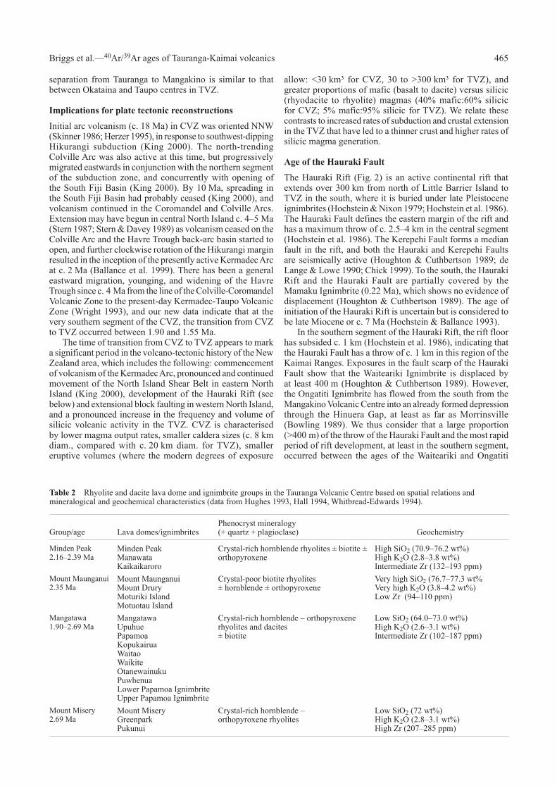
Table 2 Rhyolite and dacite lava dome and ignimbrite groups in the Tauranga Volcanic Centre based on spatial relations and mineralogical and geochemical characteristics (data from Hughes 1993, Hall 1994, Whitbread-Edwards 1994).

466 New Zealand Journal of Geology and Geophysics, 2005, Vol. 48
Ignimbrites, that is, between 2.09 ± 0.03 and 1.34–1.21 Ma. This age span coincides with the eruption of the younger dacite lavas of the Haowhenua Formation on Little Barrier Island in the northern segment of the Hauraki Rift at 1.6–1.2 Ma (Lindsay et al. 1999).
Spatial, mineralogical, and geochemical relations of silicic dome lavas in the Tauranga Volcanic Centre
The silicic dome lavas in the Tauranga area can be divided into four groups (Minden Peak, Mount Maunganui, Mangatawa, Mount Misery) based on their spatial association and mineralogical and geochemical characteristics, although their ages generally overlap. The four groups are summarised in Table 2 and their distribution is shown in Fig. 3. The mineralogical and geochemical data are from Hughes (1993), Hall (1994), and Whitbread-Edwards (1994).
The Minden Peak group forms the hornblende rhyolite domes northwest of the Wairoa River, and are characterised by high SiO2, high K2O, and intermediate Zr contents.
The Mount Maunganui group form a tight spatial cluster and have the most evolved compositions with the highest SiO2 and K2O contents and lowest Zr. The biotite rhyolite lava remnants of Motuotau and Moturiki Islands and Mount Drury are all genetically related to the lava dome of Mount Maunganui (Hall 1994).
The Mangatawa group of hornblende-orthopyroxene rhyolites and dacites may be aligned along northeast-trending faults in the basement that border the eastern segment of the Tauranga Volcanic Centre. They include the dacite domes of Upuhue and Kopukairua. The faults are not exposed at the surface, but numerous deeper older faults occur in the basement, shown in seismic reflection profiles offshore of Tauranga and the Bay of Plenty (Davey et al. 1995). The Mangatawa group lavas have low SiO2, high K2O, and intermediate Zr abundances, and are thus distinguished from the Mount Misery group, occurring in the same geographic area, which has the highest Zr contents of >200 ppm.
The silicic rocks of the Tauranga area have calc-alkaline compositions and major and trace element and isotopic compositions similar to the rhyolites of TVZ. Tauranga rhyolites and dacites also have close affinities in their mineralogical compositions with TVZ rocks, and contain variable proportions of plagioclase, quartz, calcic hornblende, orthopyroxene, biotite, titanomagnetite, ilmenite, zircon, and apatite. The clusters of spatially associated rhyolites and dacites may represent genetically related silicic magmas that were independently and broadly synchronously derived. Their concordance with TVZ silicic volcanics suggest that they have a similar genesis, involving fractionation and partial melting of the crust (e.g., Graham et al. 1995), although there is evidence that other mafic magmatic components were also involved.
The Papamoa Ignimbrites span a wide age range and vary in composition from basaltic andesite to rhyolite, and have closest mineralogical and geochemical affinities with the Mangatawa group. The range in geochemical composition in terms of SiO2, K2O, and Zr contents is not included in Table 2, but the composition of the rhyolitic pumice in the Papamoa Ignimbrites falls in the range of those in the Mangatawa group, and they lack the high Zr contents of the Mount Misery group.
Nature and definition of volcanic centres in the Tauranga-Kaimai area, in comparison with TVZ
Onshore TVZ is a northeast-trending volcano-tectonic depression that extends c. 200 km southwest of the Bay of Plenty coastline, is 60 km wide, and contains andesitic and dacitic composite volcanoes, and eight rhyolitic calderas restricted to a central segment (Houghton et al. 1995; Wilson et al. 1995). Offshore TVZ extends 150 km to the northeast to the oceanic Kermadec Arc and Havre Trough/continental crustal transition (Gamble et al. 1993). The onshore rhyolitic calderas have been recognised from the location of lava dome complexes, negative Bouguer gravity anomalies associated with silicic vents, distribution and thicknesses of ignimbrites, location of lithic lag breccia facies in proximal ignimbrites, and structural evidence for collapse (e.g., Rogan 1982; Nairn et al. 1994; Wilson et al. 1995). Some calderas are nested or partially overlap, and more than 34 caldera-forming eruptions have occurred from these 8 volcanic centres (Houghton et al. 1995).
Earlier rhyolitic volcanic centres and caldera structures may also be present within the central TVZ, but these cannot be recognised because of structural downfaulting, or burial by younger voluminous ignimbrites and other eruptives (cf. Wilson et al. 1995). For example, there are some voluminous ignimbrites such as Waimakariri Ignimbrite whose sources are uncertain and that cannot be definitively attributed to any
Fig. 3 Map of the Tauranga area showing the geographical distribution and age of the four groups of silicic domes and flows comprising the Tauranga Volcanic Centre.

467 Briggs et al.—40Ar/39Ar ages of Tauranga-Kaimai volcanics
of the presently known caldera volcanic centres in the TVZ (Milner 2001). In most cases, the rhyolite domes and lavas in the TVZ lie within or on the rims of calderas, or else are situated just outside the caldera rims. The only exceptions to this are some extra-caldera domes and associated subordinate pyroclastics southwest and southeast of the Taupo caldera that are linked geochemically to some intracaldera eruptives (Sutton et al. 1995).
The silicic rocks of the Tauranga-Kaimai area occur in spatially associated groups or volcanic centres, but there is no evidence for collapse structures or calderas. The negative Bouguer gravity anomaly in the northwestern area of the Tauranga Basin between Katikati and Matakana Island, described by Woodward & Ferry (1973), might indicate a caldera or collapse structure. However, it does not coincide with the distribution of the rhyolite and dacite domes and flows of the Tauranga-Kaimai area that lie well to the south and southeast. Lacustrine diatomaceous siltstones are found in many places in the Tauranga area (e.g., Matakana Island; Hollis 1995), but there is no evidence that these siltstones were deposited in caldera lakes. Circular or arcuate structures that may indicate caldera structures have been observed by remote sensing farther north in the CVZ (Skinner 1986; Belliss & Christie 1994; Christie et al. 1994; Krippner 2000), but have not been seen in the Tauranga-Kaimai area. Harmsworth (1983) recorded numerous buried rhyolitic lavas intersected by drill cores in the Tauranga Basin, and hence if Pliocene caldera structures did exist in the Tauranga-Kaimai area, they are now buried and obscured by younger volcanic and sedimentary infill. Alternatively, these calderas may never have formed, because the ignimbrite eruptions were not voluminous enough to be caldera forming.
Because there is no evidence for calderas or collapse structures in the Tauranga-Kaimai area, the groups of silicic domes and flows and associated ignimbrites are designated as silicic volcanic centres and not as calderas, and this terminology and distinction from TVZ calderas is adopted in Fig. 2. We thus recognise two centres of silicic volcanism in the Tauranga-Kaimai area.
(1) The Kaimai Volcanic Centre (KaiVC) (2.87–2.09 Ma): This centre includes the large voluminous rhyolite domes of Kaimai (2.86 ± 0.08 Ma) and Kakahu (2.87 ± 0.02 Ma), and the Waiteariki Ignimbrite (2.09 ± 0.03 Ma). The boundaries and size of the centre are poorly defined because of poor exposures, burial by younger ignimbrites, the extensive cover of the Waiteariki Ignimbrite itself, and dislocation by the Hauraki Fault.
(2) The Tauranga Volcanic Centre (TgaVC) (2.69–1.90 Ma): This centre includes the Minden Peak, Mount Maunganui, Mangatawa, and Mount Misery groups of rhyolitic and dacitic domes and flows (2.69–1.95 Ma) and Papamoa Ignimbrites (2.40–1.90 Ma). The centre is situated in the southeastern part of the Tauranga Basin, but the boundaries and size of the centre are also poorly known and there are no gravity lows or circular or arcuate structures. Younger ignimbrites from the TVZ and thick volcaniclastic infill have mainly covered and obscured the boundaries and any pre-existing structures.
ACKNOWLEDGMENTS
We thank Glen Hughes for mineral separations and preparation of samples for 40Ar/39Ar analysis, and Mike Morgan for unpublished data on the southern Kaimai Range. We also thank Max Oulton for
the graphics, and the Department of Earth Sciences, University of Waikato, for their support. BFH and CJNW acknowledge financial support from the Foundation for Research, Science and Technology. John Gamble and Jim Cole provided useful reviews which have improved the manuscript.
REFERENCES
Adams CJ, Graham IJ, Seward D, Skinner DNB 1994. Geochronological and geochemical evolution of late Cenozoic volcanism in the Coromandel Peninsula, New Zealand. New Zealand Journal of Geology and Geophysics 37: 359–379.
Alloway BV, Pillans BJ, Sandhu AS, Westgate JA 1993. Revision of the marine chronology in the Wanganui Basin, New Zealand, based on the isothermal plateau fission-track dating of tephra horizons. Sedimentary Geology 82: 299–310.
Ballance PF, Ablaev AG, Pushkin IK, Pletnev SP, Birylina MG, Itaya T, Follas HA, Gibson GW 1999. Morphology and history of the Kermadec trench-arc-backarc basin-remnant arc system at 30 to 32ºS: geophysical profile, microfossil and K-Ar data. Marine Geology 159: 35–62.
Belliss SE, Christie AB 1994. Processing of Japan earth resources—1 Synthetic aperture radar data to aid geological mapping in the central Coromandel Peninsula. Proceedings of the Australasian Institute of Mining and Metallurgy 28th annual conference. Pp. 33–49.
Berggren WA, Hilgen FJ, Langereis CG, Kent DV, Obradovich JD, Raffi I, Raymo ME, Shackelton NJ 1995. Late Neogene chronology: new perspectives in high-resolution stratigraphy. Geological Society of America Bulletin 107: 1272–1287.
Bibby HM, Caldwell TG, Davey FJ, Webb TH 1995. Geophysical evidence on the structure of the Taupo Volcanic Zone and its hydrothermal circulation. Journal of Volcanology and Geothermal Research 68: 29–58.
Bowling FM 1989. Volcanic geology of ignimbrites on the western margin of the Hauraki Depression and in the Mangatangi area. Unpublished MSc thesis, lodged in the Library, University of Waikato, Hamilton, New Zealand.
Brathwaite RL, Christie AB 1996. Part sheets T13 and U13—Waihi. Geological map of New Zealand 1:50 000. Map and notes. Institute of Geological & Nuclear Sciences, Lower Hutt, New Zealand.
Briggs RM, Hall GJ, Harmsworth GR, Hollis AG, Houghton BF, Hughes GR, Morgan MD, Whitbread-Edwards AR 1996. Geology of the Tauranga area, sheet U14 1:50 000. Occasional Report 22. Department of Earth Sciences, University of Waikato, Hamilton, New Zealand.
Carter L, Shane PA, Alloway BV, Hall IR, Harris SE, Westgate JA 2003. Demise of one volcanic zone and birth of another—a 12 Ma marine record of major rhyolitic eruptions from New Zealand. Geology 31: 493–496.
Carter RM, McCave IN, Richter C, Carter L and others 1999. Proceedings of the Ocean Drilling Program: initial reports 181. College Station, Texas (Ocean Drilling Program) (CD-ROM).
Chick LM 1999. Potential tsunami hazard associated with the Kerepehi Fault, Hauraki Gulf, New Zealand. Unpublished MSc thesis, lodged in the Library, University of Waikato, Hamilton, New Zealand.
Christie AB, Belliss SE, Brathwaite RL 1994. Use of remote sensing data to aid geological mapping of the Waihi 1:50 000 scale map sheet, Coromandel region. Proceedings of the Australasian Institute of Mining and Metallurgy 28th annual conference. Pp. 51–65.
Davey FJ, Henrys SA, Lodolo E 1995. Asymmetric rifting in a continental back-arc environment, North Island, New Zealand. Journal of Volcanology and Geothermal Research 68: 209–238.

468 New Zealand Journal of Geology and Geophysics, 2005, Vol. 48
de Lange PJ, Lowe DJ 1990. History of vertical displacement of Kerepehi Fault at Kopouatai bog, Hauraki Lowlands, New Zealand, since 10 700 years ago. New Zealand Journal of Geology and Geophysics 33: 277–283.
Fransen PJB 1982. Geology of the western Mamaku Plateau and variations in the Mamaku Ignimbrite. Unpublished MSc thesis, lodged in the Library, University of Waikato, Hamilton, New Zealand.
Fransen PJB, Briggs RM 1981. Ignimbrites at Karapiro-Putaruru. Geological Society of New Zealand Miscellaneous Publication 29B: 29–34.
Gamble JA, Wright IC, Baker JA 1993. Seafloor geology and petrology in the oceanic to continental transition zone of the Kermadec-Havre-Taupo Volcanic Zone arc system, New Zealand. New Zealand Journal of Geology and Geophysics 36: 417–435.
Graham IJ, Cole JW, Briggs RM, Gamble JA, Smith IEM 1995. Petrology and petrogenesis of volcanic rocks from the Taupo Volcanic Zone: a review. Journal of Volcanology and Geothermal Research 68: 59–87.
Hall GJ 1994. Volcanic geology of the southeastern Tauranga Basin, New Zealand. Unpublished MSc thesis, lodged in the Library, University of Waikato, Hamilton, New Zealand.
Harmsworth GR 1983. Quaternary stratigraphy of the Tauranga Basin. Unpublished MSc thesis, lodged in the Library, University of Waikato, Hamilton, New Zealand.
Hayward BW, Black PM, Smith IEM, Ballance PF, Itaya T, Doi M, Takagi M, Bergman S, Adams CJ, Herzer RH, Robertson DJ 2001. K-Ar ages of early Miocene arc-type volcanoes in northern New Zealand. New Zealand Journal of Geology and Geophysics 44: 285–312.
Henry MAC 1991. The volcanic geology of Motiti Island. Unpublished MSc thesis, lodged in the Library, University of Waikato, Hamilton, New Zealand.
Herzer RH 1995. Seismic stratigraphy of a buried volcanic arc, Northland, New Zealand and implications for Neogene subduction. Marine and Petroleum Geology 12: 511–531.
Hochstein MP, Ballance PF 1993. Hauraki Rift: a young, active, intra-continental rift in a back-arc setting. In: Ballance PF ed. South Pacific sedimentary basins. Elsevier, Amsterdam. Pp. 295–305.
Hochstein MP, Nixon IM 1979. Geophysical study of the Hauraki Depression, North Island, New Zealand. New Zealand Journal of Geology and Geophysics 22: 1–19.
Hochstein MP, Tearney K, Rawson K, Davey FJ, Davidge S, Henrys S, Backshall D 1986. Structure of the Hauraki Rift (New Zealand). Royal Society of New Zealand Bulletin 24: 333–348.
Hollis AG 1995. Volcanic geology of the central Tauranga Basin, New Zealand. Unpublished MSc thesis, lodged in the Library, University of Waikato, Hamilton, New Zealand.
Hoskin PWO, Wysoczanski RJ, Briggs RM 1998. U-Pb age determination of “Lenticulite” (Owharoa Ignimbrite) at Waikino, Waihi area, Coromandel Peninsula, and implications (abstract). Geological Society of New Zealand Miscellaneous Publication 101A: 123.
Houghton BF, Cuthbertson AS 1989. Sheet T14 BD—Kaimai. Geological map of New Zealand 1:50 000. Wellington, New Zealand, Department of Scientific and Industrial Research.
Houghton BF, Wilson CJN, McWilliams MO, Lanphere MA, Weaver SD, Briggs RM, Pringle MS 1995. Chronology and dynamics of a large silicic magmatic system: central Taupo Volcanic Zone, New Zealand. Geology 23: 13–16.
Hughes GR 1993. Volcanic geology of the eastern Tauranga Basin and Papamoa Range. Unpublished MSc thesis, lodged in the Library, University of Waikato, Hamilton, New Zealand.
Kear D 1994. A “least complex” dynamic model for late Cenozoic volcanism in the North Island, New Zealand. New Zealand Journal of Geology and Geophysics 37: 223–236.
King PR 2000. Tectonic reconstructions of New Zealand: 40 Ma to the present. New Zealand Journal of Geology and Geophysics 43: 611–638.
Kohn BP 1973. Some studies of New Zealand pyroclastic rocks. Unpublished PhD thesis, lodged in the Library, Victoria University of Wellington, Wellington, New Zealand.
Krippner SJP 2000. Volcanic geology, geochemistry and geochronology of the Kapowai Caldera Complex, Coromandel Volcanic Zone, New Zealand. Unpublished PhD thesis, lodged in the Library, University of Waikato, Hamilton, New Zealand.
Lindsay JM, Worthington TJ, Smith IEM, Black PM 1999. Geology, petrology, and petrogenesis of Little Barrier Island, Hauraki Gulf, New Zealand. New Zealand Journal of Geology and Geophysics 42: 155–168.
Lowe DJ, Tippett MJ, Kamp PJJ, Liddell IJ, Briggs RM, Horrocks JL 2001. Ages on weathered Plio-Pleistocene tephra sequences, western North Island, New Zealand. In: Juvigné ET, Raynal J-P ed. Tephras: chronology, archaeology. CDERAD editeur, Goudet. Les Dossiers de l’Archeo-Logis 1: 45–60.
Malengreau B, Skinner DNB, Bromley C, Black PM 2000. Geophysical characterisation of large silicic volcanic structures in the Coromandel Peninsula, New Zealand. New Zealand Journal of Geology and Geophysics 43: 171–186.
Milner DM 2001. The structure and eruptive history of Rotorua caldera, Taupo Volcanic Zone, New Zealand. Unpublished PhD thesis, lodged in the Library, University of Canterbury, Christchurch, New Zealand.
Nairn IA, Wood CP, Bailey RA 1994. The Reporoa caldera, Taupo Volcanic Zone: source of the Kaingaroa Ignimbrites. Bulletin of Volcanology 56: 529–537.
Rogan AM 1982. A geophysical study of the Taupo Volcanic Zone, New Zealand. Journal of Geophysical Research 87: 4073–4088.
Rutherford NF 1978. Fission-track ages and trace element geochemistry of some Minden Rhyolite obsidians. New Zealand Journal of Geology and Geophysics 21: 443–448.
Shane PAR, Black TM, Alloway BV, Westgate JA 1996. Early to middle Pleistocene tephrochronology of North Island, New Zealand: implications for volcanism, tectonism, and paleoenvironments. Geological Society of America Bulletin 108: 915–925.
Skinner DNB 1986. Neogene volcanism of the Hauraki volcanic region. In: Smith IEM ed. Late Cenozoic volcanism in New Zealand. Royal Society of New Zealand Bulletin 23: 21–47.
Soengkono S, Hochstein MP, Smith IEM, Itaya T 1992. Geophysical evidence for widespread reversely magnetised pyroclastics in the western Taupo Volcanic Zone (New Zealand). New Zealand Journal of Geology and Geophysics 35: 47–55.
Stern TA 1987. Asymmetric back-arc spreading, heat flux and structure associated with the Central Volcanic Region of New Zealand. Earth and Planetary Science Letters 85: 265–276.
Stern TA, Davey FJ 1989. Crustal structure and origin of basins formed behind the Hikurangi subduction zone, New Zealand. In: Price RA ed. Origin and evolution of sedimentary basins and their energy and mineral resources. Washington DC, American Geophysical Union. Geophysical Monograph 48: 73–85.
Stipp JJ 1968. The geochronology and petrogenesis of the Cenozoic volcanics of North Island, New Zealand. Unpublished PhD thesis, Australian National University, Canberra, Australia.
Sutton AN, Blake S, Wilson CJN 1995. An outline geochemistry of rhyolite eruptives from Taupo volcanic centre, New Zealand. Journal of Volcanology and Geothermal Research 68: 153–175.
Takagi M 1995. Miocene–Pliocene arc volcanism of the Hauraki region in North Island, New Zealand. Unpublished MSc thesis, Okayama University of Science, Okayama, Japan.
469 Briggs et al.—40Ar/39Ar ages of Tauranga-Kaimai volcanics
Tanaka H, Turner GM, Houghton BF, Tachibana T, Kono M, McWilliams MO 1996. Palaeomagnetism and chronology of the central Taupo Volcanic Zone, New Zealand. Geophysical Journal International 124: 919–934.
Ward GK, Wilson SR 1978. Procedures for comparing and combining radiocarbon age determinations: a critique. Archaeometry 20: 19–31.
Westgate JA 1989. Isothermal plateau fission-track ages of hydrated glass shards from silicic tephra beds. Earth and Planetary Science Letters 95: 226–234.
Whitbread-Edwards AN 1994. The volcanic geology of the western Tauranga Basin. Unpublished MSc thesis, lodged in the Library, University of Waikato, Hamilton, New Zealand.
Wilson CJN 1986. Reconnaissance stratigraphy and volcanology of ignimbrites from Mangakino volcano. In: Smith IEM ed. Late Cenozoic volcanism in New Zealand. Royal Society of New Zealand Bulletin 23: 179–193.
Wilson CJN, Rogan AM, Smith IEM, Northey DJ, Nairn IA, Houghton BF 1984. Caldera volcanoes of the Taupo Volcanic Zone, New Zealand. Journal of Geophysical Research 89: 8463–8484.
Wilson CJN, Houghton BF, McWilliams MO, Lanphere MA, Weaver SD, Briggs RM 1995. Volcanic and structural evolution of Taupo Volcanic Zone, New Zealand: a review. Journal of Volcanology and Geothermal Research 68: 1–28.
Woodward DJ, Ferry LM 1973. Sheet 5—Rotorua. Gravity map of New Zealand 1:250 000. Isostatic vertical gradient anomalies. Wellington, New Zealand, Department of Scientific and Industrial Research.
Wright IC 1993. Southern Havre Trough–Bay of Plenty (New Zealand): structure and seismic stratigraphy of an active back-arc basin complex. In: Ballance PF ed. Sedimentary basins of the world. South Pacific sedimentary basins 2. Pp. 195–211.


![Tauranga Boys’ College Newsletter - tbc.ibcdn.nz · TBC 664 Cameron Road, Tauranga 3112 New Zealand: [64] (07) 578 4029: Principal R W Mangan: TAURANGABOYSCOLLEGE Tauranga Boys’](https://img.dokumen.tips/doc/110x75/5cd254b988c993a34d8c636a/tauranga-boys-college-newsletter-tbcibcdnnz-tbc-664-cameron-road-tauranga.jpg)