Embed Size (px)
Citation preview

See discussions, stats, and author profiles for this publication at: https://www.researchgate.net/publication/316473107
Aquatic Sciences and Wetland Management
Book · August 2010
CITATIONS
0READS
3,120
1 author:
Mulugeta Wakjira
Jimma University
14 PUBLICATIONS 20 CITATIONS
SEE PROFILE
All content following this page was uploaded by Mulugeta Wakjira on 26 April 2017.
The user has requested enhancement of the downloaded file.
Aquatic Sciences and Wetlands Management (Biol 302)
A Module
On
Aquatic Sciences and Wetland Management
(Biol 302)
Written by:
Mulugeta Wakjira (M.Sc.)
Reviewed by:
Dereje Denu (M.Sc.)
Tadesse Habtamu (M.Sc.)
© CDE, Jimma University, Ethiopia
August, 2010
Jimma, Ethiopia
A Module for Aquatic Sciences and Wetland Management (Biol 302)
Mulugeta Wakjira, Department of Biology, Jimma University, August, 2010
i
Table of Contents
Preface.............................................................................................................. iii
Chapter 1: Introduction to Aquatic and Wetland Ecosystems ........................ 1
1.1. Definitions and Global Proportions ....................................................... 1
1.2. The Inland Aquatic Ecosystems............................................................. 4
1.2.1. Lentic Freshwater Ecosystems ........................................................ 5
1.2.2. Lotic Freshwater Ecosystems ......................................................... 8
1.3. Marine Ecosystems .............................................................................. 10
1.4. Estuarine Ecosystems........................................................................... 12
1.5. Wetland Ecosystems ............................................................................ 12
Chapter 2: Major Freshwater Bodies and Wetlands of Ethiopia .................. 15
2.1. Catchments/Drainage Basins ............................................................... 15
2.2. Drainage Basins of Ethiopia ................................................................ 19
2.2.1. The Ethiopian Drainage Systems .................................................. 19
2.2.2. Lakes ............................................................................................. 21
2.2.3. Rivers ............................................................................................ 22
2.2.4. Wetlands ....................................................................................... 25
Chapter 3. Ecology of Aquatic Ecosystems .................................................. 29
3.1. Zonations in Aquatic Ecosystems ........................................................ 29
3.1.1. Zonations in Freshwater Ecosystems ............................................ 29
3.1.2. Zonations in Marine Ecosystems .................................................. 31
3.2. Autochotonus and Allochtonous Inputs ............................................... 35
3.3. Community Structure ........................................................................... 35
3.3.1. Plankton community ..................................................................... 35
3.3.2. Nekton and Benthic communities ................................................. 39
3.4. Aquatic Ecology................................................................................... 40
3.4.1. Abiotic Components ..................................................................... 40
3.4.2. Functional Feeding Groups ........................................................... 40
Chapter 4: Water Pollution ............................................................................ 43
4.1. What is Water Pollution ....................................................................... 43
A Module for Aquatic Sciences and Wetland Management (Biol 302)
Mulugeta Wakjira, Department of Biology, Jimma University, August, 2010
ii
4.2. Sources of Water Pollution .................................................................. 44
4.3. Types of Water Pollutions and the Contaminants................................ 45
4.4. Forests and Water Quality ................................................................... 53
Chapter 5: Water Quality Assessment........................................................... 57
5.1. Water Quality ....................................................................................... 57
5.2. Water Quality Assessment Parameters ................................................ 58
5.2.1. Physico-chemical Parameters ....................................................... 60
5.2.2. Biological Parameters ................................................................... 66
5.2.3. Sampling of Surface Waters ......................................................... 71
Chapter 6: Aquatic Resources ....................................................................... 77
6.1 Fish and Fisheries ................................................................................. 77
6.2. The Ethiopian Fish and Fisheries ......................................................... 83
6.2.1. The Classification of Ethiopian Fish ............................................. 83
6.2.2. The Ethiopian Fisheries ................................................................ 86
Chapter 7. Water Basin Management and Monitoring.................................. 91
7.1. Basic Water Management and Monitoring Programs .......................... 91
7.2. The Nile Basin Initiative (NBI) ........................................................... 92
7.3. The Water Framework Directive ......................................................... 98
7.4. Convention on Wetlands Management ................................................ 99
References .................................................................................................... 103
Appendix-1. List of some of the benthic macroinvertebrates according to their
sensitivity and tolerance to water pollution .................................................. 105
Appendix 2: Some of the biological indexes and scores of macroinvertebrates
in water quality assessment ........................................................................... 108
Appendix-3: Trophic classification scheme for lake waters proposed by the
OECD based on the chlorophyll a concentration .......................................... 111
Appendix-4: Some Representative Fishes in the Major Lakes and Rivers of
Ethiopia ......................................................................................................... 112
Appendix-5: A Map showing The Nile Basin (shown in white colour) ...... 113
Appendix 6: Assignment ............................................................................. 114
A Module for Aquatic Sciences and Wetland Management (Biol 302)
Mulugeta Wakjira, Department of Biology, Jimma University, August, 2010
iii
Preface
quatic ecosystems generate a greater proportion of oxygen to the
atmosphere and serve as a sink for a larger quantity of carbondioxide.
They are homes to significant proportion of world biodiversity and also play a
central role in maintaining the balance of nature. Fish (finfish and shellfish)
are important sources of protein to human being. Moreover, freshwaters
render much more benefits. For instance, they are important in hydropower
generations, agricultural irrigations, navigations, drinking water supply, etc.
Nowadays the global aquatic ecosystems, especially freshwaters, are being
threatened due to over use and other human impacts. This, thus, calls for their
proper utilization and management to allow them continue functioning
sustainably. Though studies on aquatic sciences are not abundant in Ethiopia,
the country is no exception to the scenario as can be learned from the scant
reports. Thus, in order to mitigate the problem, knowledge of aquatic
ecosystems and their dynamics is crucial. And this in turn calls for the
incorporation of aquatic science and fishery courses in the curricula of higher
learning institutions which has not been a case in Ethiopia so far.
Therefore, the knowledge gained by the students from this course is believed
to be of paramount importance in giving them some insights and awareness
about the aquatic ecosystems, their dynamics and management. However,
given the very short time to prepare and review the material, the writer would
like to kindly request readers to reasonably forward their constructive
comments for improvement to email addresses: [email protected]
The Writer
A

A Module for Aquatic Sciences and Wetland Management (Biol 302)
Mulugeta Wakjira, Department of Biology, Jimma University, August, 2010
1
Chapter 1: Introduction to Aquatic and Wetland Ecosystems
Chapter Objectives:
At the end of this chapter you will be able to:
� Define an aquatic ecosystem
� Distinguish between the freshwater, marine and estuarine ecosystems
� Describe the freshwater, marine and estuarine ecosystems
� Distinguish between the lentic and lotic inland aquatic ecosystems
� Describe the wetland ecosystems
� Explain the global and relative proportions of aquatic ecosystems.
1.1. Definitions and Global Proportions
Activity:
��� Dear student, from your ecology course can you remember about
ecosystem? What is an ecosystem? What are the two major categories of
world ecosystems?
Dear student, let us now proceed to defining one of the two major ecosystem
categories: Aquatic ecosystem.
This is a water ecosystem that provides many vital environmental functions
both to human being and other organisms. For example:
��� They are important in nutrient recycling, flood attenuation and habitats
provision to wildlife (biodiversity).
��� The largest proportion of rainfall comes from evaporation of water
bodies.
��� They are also used for human recreation, and are very important to the
tourism industry, especially in coastal regions.
A Module for Aquatic Sciences and Wetland Management (Biol 302)
Mulugeta Wakjira, Department of Biology, Jimma University, August, 2010
2
Activity:
��� As it is a case with any type of ecosystem, what are the two major factors
or components of aquatic ecosystems? Write down before you pass on to
read the following sections.
Aquatic ecosystems are composed of biotic communities (also called biota)
and abiotic environmental factors, which form a self-regulating and self-
sustaining unit. The biotic components of aquatic ecosystems are either
autotrophic or heterotrophic as described in chapter 3.
Activity:
� What is the difference between autotrophic and heterotrophic organisms in
aquatic habitats? Give examples.
Abiotic environmental factors of aquatic ecosystems include the amount of
dissolved oxygen (DO), temperature, amount of light, salinity, pH, nutrients
such as nitrogen (in the form of mainly nitrates) and phosphorus (in the form
of phosphates). Refer to section 5.2.1. of chapter 5 for more information on
the abiotic components of aquatic ecosystem.
The amount of dissolved oxygen in a water body is frequently the key
substance in determining the extent and kinds of organic life in the water
body. Fish need dissolved oxygen to survive. Conversely, oxygen is fatal to
many kinds of anaerobic bacteria. The salinity of the water body is also a
determining factor in the kinds of species found in the water body. Organisms
in marine ecosystems tolerate salinity, while many freshwater organisms are
intolerant of salt. Freshwater used for irrigation purposes often absorb levels
of salt that are harmful to freshwater organisms.
A Module for Aquatic Sciences and Wetland Management (Biol 302)
Mulugeta Wakjira, Department of Biology, Jimma University, August, 2010
3
Activity:
� Aquatic ecosystems can be broadly categorized in to three. What do you
call them? What are the major differences that lie among the three?
There are three major types of aquatic ecosystems:
��� Inland (mainly freshwater) Aquatic Ecosystems
��� Marine Ecosystems
��� Estuarine Ecosystems
The inland aquatic ecosystems include lakes, rivers and streams that have
negligible salinity (salt content) of a little greater than or equal to 10 gram of
salt per 1 liter of water. The waters of inland aquatic ecosystems are said to be
largely freshwater with an exception of a few salty lakes.
Activity:
��� In Ethiopia can you give examples of salty lake? Name it.
The marine ecosystems include seas and oceans and are characterized by high
salinity reaching 370 gram of salt per liter of water. All marine waters are
salty. The estuarine ecosystems are areas formed at the junction of the
freshwater and marine waters.
Activity:
��� How do you compare the salt content of estuarine waters to that of
freshwaters and marine waters? Explain.
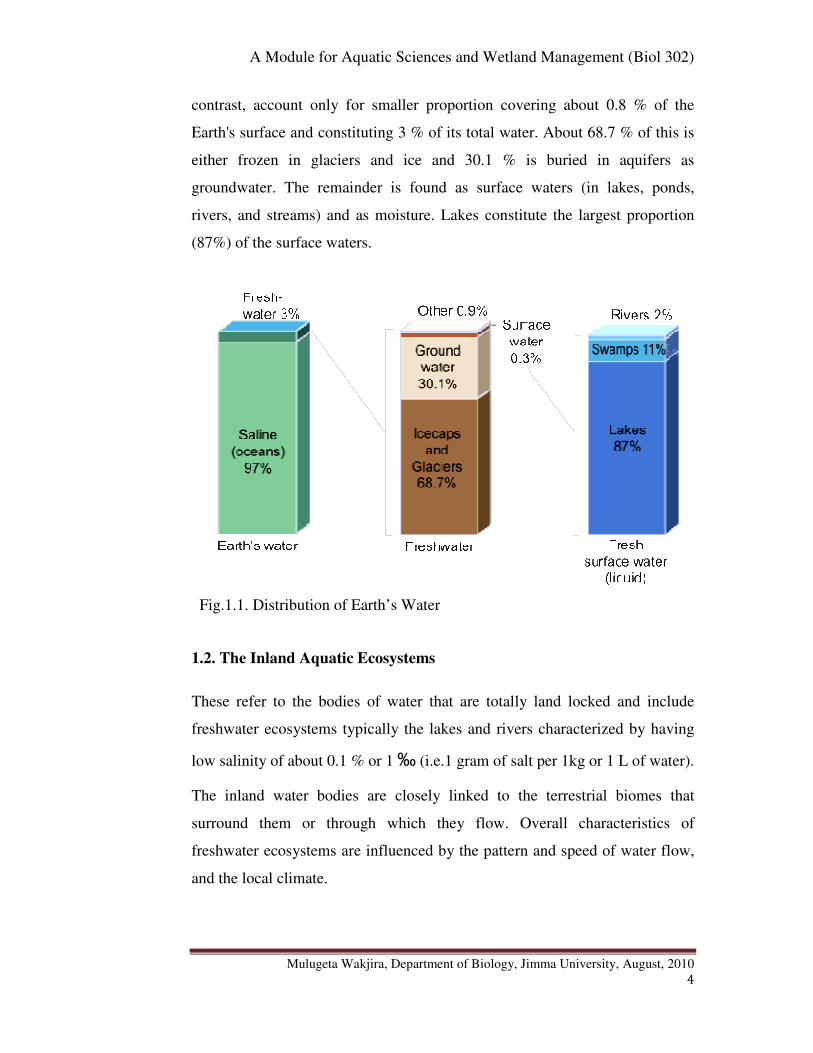
The largest proportion, about 75 %, of the Earth’s surface is covered by water.
Marine ecosystems cover approximately 71 % of the Earth's surface and
constitute about 97 % of the planet's water. The inland aquatic ecosystems, in
A Module for Aquatic Sciences and Wetland Management (Biol 302)
Mulugeta Wakjira, Department of Biology, Jimma University, August, 2010
4
contrast, account only for smaller proportion covering about 0.8 % of the
Earth's surface and constituting 3 % of its total water. About 68.7 % of this is
either frozen in glaciers and ice and 30.1 % is buried in aquifers as
groundwater. The remainder is found as surface waters (in lakes, ponds,
rivers, and streams) and as moisture. Lakes constitute the largest proportion
(87%) of the surface waters.
Fig.1.1. Distribution of Earth’s Water
1.2. The Inland Aquatic Ecosystems
These refer to the bodies of water that are totally land locked and include
freshwater ecosystems typically the lakes and rivers characterized by having
low salinity of about 0.1 % or 1 ‰ (i.e.1 gram of salt per 1kg or 1 L of water).
The inland water bodies are closely linked to the terrestrial biomes that
surround them or through which they flow. Overall characteristics of
freshwater ecosystems are influenced by the pattern and speed of water flow,
and the local climate.
A Module for Aquatic Sciences and Wetland Management (Biol 302)
Mulugeta Wakjira, Department of Biology, Jimma University, August, 2010
5
The freshwater ecosystems generate nearly 3 % of net primary production and
contain 41% of the world's known fish species. Three basic types of inland
aquatic ecosystems can be recognized. These are lentic, lotic and wetland
ecosystems.
� Lentic freshwater ecosystems are standing freshwater ecosystems such
as lakes and ponds.
� Lotic freshwater ecosystems are the rapidly moving freshwater
ecosystems such as rivers and streams.
1.2.1. Lentic Freshwater Ecosystems
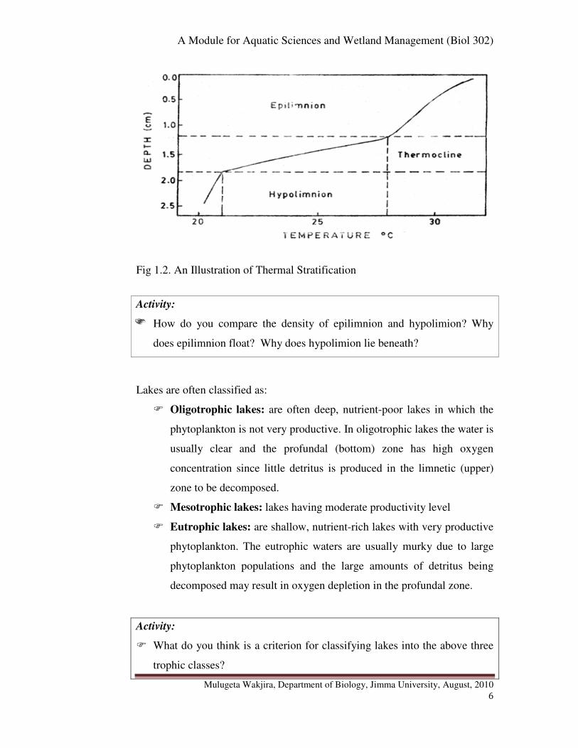
Lakes and deeper ponds exhibit temperature stratification known as thermal
stratification during the summer (warmer) and winter seasons in temperate
zones.
Activity:
��� What is thermal stratification of lakes and deeper ponds? How is it
formed? What factors cause the creation of thermal stratification?
However, the effect of thermal stratitifcation is more pronounced during
summer season when still air condition is more prevalent. Sunlight heats the
upper layers of water as far as it penetrates and the deeper water remains cold.
Consequently the warmer upper water (known as epilimnion) becomes
separated from the lower colder water (known as hypolimion). A narrow zone
of water that separates between the warmer and colder waters undergoes a
rapid or exponential temperature change and it is known as thermocline (See
Fig. 1.2. below)
A Module for Aquatic Sciences and Wetland Management (Biol 302)
Mulugeta Wakjira, Department of Biology, Jimma University, August, 2010
6
Fig 1.2. An Illustration of Thermal Stratification
Activity:
��� How do you compare the density of epilimnion and hypolimion? Why
does epilimnion float? Why does hypolimion lie beneath?
Lakes are often classified as:
� Oligotrophic lakes: are often deep, nutrient-poor lakes in which the
phytoplankton is not very productive. In oligotrophic lakes the water is
usually clear and the profundal (bottom) zone has high oxygen
concentration since little detritus is produced in the limnetic (upper)
zone to be decomposed.
� Mesotrophic lakes: lakes having moderate productivity level
� Eutrophic lakes: are shallow, nutrient-rich lakes with very productive
phytoplankton. The eutrophic waters are usually murky due to large
phytoplankton populations and the large amounts of detritus being
decomposed may result in oxygen depletion in the profundal zone.
Activity:
� What do you think is a criterion for classifying lakes into the above three
trophic classes?
A Module for Aquatic Sciences and Wetland Management (Biol 302)
Mulugeta Wakjira, Department of Biology, Jimma University, August, 2010
7
The classification of lakes in to such trophic classes is based on the level of
productivity or amount of organic matter produced. Trophic status of a lake
thus reflects the productivity level of a lake.
Activity:
� Do you think that an oligotrophic lake remains less productive for ever or
it can develop into more productive (eutrophic) lake? Explain how.
Oligotrophic lakes may develop into eutrophic lakes over time if runoff from
surrounding terrestrial habitats brings in mineral nutrients such as nitrates and
phosphates.
Activity:
� Which human activities do you think may increase the nutrient content of
runoff and thus can cause lake eutrophication?
Human activities increase the nutrient content of runoff through:
� Lawn and agricultural fertilizers
� Municipal wastes
These activities enrich lakes with the nitrogen and phosphorus concentrations
which in turn increases phytoplankton and plant growth. Algal blooms and
increased plant growth results in more detritus and can lead to oxygen
depletion due to increased decomposition.
Activity:
� What is detritus? How does it pose oxygen depletion or shortage in the
water?
Moreover, Lake Ecosystems can be divided into various horizontal and
vertical zones such as littoral, limnetic and profundal (See section 3.1).
A Module for Aquatic Sciences and Wetland Management (Biol 302)
Mulugeta Wakjira, Department of Biology, Jimma University, August, 2010
8
Activity:
� Dear student, we are now coming to another type of lentic ecosystem:
Ponds. How do ponds differ from lakes? Write down your answer.
Ponds are a specific type of freshwater ecosystems that are largely based on
the autotrophic algae which provide the base trophic level for all life in the
area. The largest predator in a pond ecosystem is normally fish and in-
between range smaller insects and microorganisms. It may have a scale of
organisms from small bacteria to big creatures like water snakes, beetles,
water bugs, frogs, tadpoles, and turtles.
1.2.2. Lotic Freshwater Ecosystems
Lotic ecosystems are water bodies such as rivers and streams that move
continuously in one direction. The structure of lotic ecosystems changes from
their point of origin (headwaters) to where they empty into a larger body of
water (mouth).
Activity:
� How does the water at the headwater differ from that at the or near the
river mouth? Why?
At the headwaters, the water:
� Is cold and clear
� Carries little sediment
� Has few mineral nutrients
� The channel is narrow with a rocky substrate
� The water flows turbulently
Near the mouth, the water:
A Module for Aquatic Sciences and Wetland Management (Biol 302)
Mulugeta Wakjira, Department of Biology, Jimma University, August, 2010
9
� Moves slowly and is more turbid due to sediment entering from
other streams and erosion
� The nutrient content is also higher
� The channel is usually wider with a silty substrate that has resulted
from deposition of silt.
Activity:
� What factors influence the rate of flow, nutrient content, amount of
oxygen, turbidity, etc of rivers and streams?
Rivers with rough and shallow bottoms produce turbulent flow known as
riffles. In contrast, rivers with smooth and deep bottoms result in a slower,
smooth flow called pools.
Nutrient content of the water is higher in streams and rivers flowing through
densely vegetated regions due to leaves and other vegetation entering the
water adding organic matter and where erosion takes place which increases
inorganic nutrient content.
Oxygen content of the water is affected by the flow rate;
� Turbulent flow constantly oxygenates the water giving rise to
greater biodiversity
� While slow pool water contains relatively little oxygen and poor
biodiversity.
Turbidity reflects the amount of material suspended in the water; streams and
rivers flowing through areas of high erosion will have more suspended
materials than those surrounded by hard substrates. Large amounts of
suspended organic matter also increase turbidity.
The biological communities found in rivers and streams also differ from
headwaters to mouth; they also differ from those found in ponds and lakes. In
A Module for Aquatic Sciences and Wetland Management (Biol 302)
Mulugeta Wakjira, Department of Biology, Jimma University, August, 2010
10
upstream areas where water is cool, clear and has high oxygen content, many
insects and fish are found.
Due to the relatively high water current, large plankton communities are not
common in rivers and streams. Thus photosynthesis which supports the food
chains is a function of attached algae and rooted plants.
1.3. Marine Ecosystems
Marine ecosystems provide most of the planet's rainfall through evaporation.
The world's climate and wind patterns are also affected by ocean
temperatures. They generate 32 % of the world's net primary production.
Marine algae produce a large portion of the Earth's oxygen and consume large
amounts of carbon dioxide. Although the actual salinity varies among
different marine ecosystems, they are generally characterized by high salinity
of 3.7 % or 37 ‰ (i.e. 37 grams of salt per 1 kg or 1 L of water). Marine
ecosystems can be divided into various horizontal and vertical zones such as
intertidal (littoral), neritic, oceanic, etc (See section 3.1).
Activity:
� Dear student, can you mention some examples of abiotic factors that can
affect the ecology of marine ecosystems?
The following some examples of abiotic factors important in marine ecology:
� Temperature affects biological processes and the ability of most
organisms to regulate their body temperature. Temperature affects
metabolism: few organisms have active metabolisms at temperatures close
to 0º C and temperatures above 45º C denature most essential enzymes.
The actual body temperature of ectotherms is affected by heat exchange
A Module for Aquatic Sciences and Wetland Management (Biol 302)
Mulugeta Wakjira, Department of Biology, Jimma University, August, 2010
11
with the environment; most animals maintain a body temperature only a
few degrees above or below ambient temperature. Even endotherms
function best within the temperature range to which they are adapted.
� Salinity: marine organisms can be euryhaline (i.e. wide range of
tolerance) or stenohaline (narrow range of tolerance) according to their
salt tolerance.
� Sunlight provides the energy that drives nearly all ecosystems although
only photosynthetic organisms use it directly as an energy source. In
aquatic environments, water selectivity reflects and absorbs certain
wavelengths; therefore, most photosynthesis occurs near the water surface.
The physiology, development, and behaviour of many animals and plants
are often sensitive to photoperiod.
� Rocks and soil: The physical structure, pH, and mineral composition of
soil limit distribution of plants and hence animals that feed on those
plants. The composition of the substrate in a stream or river greatly
influences the water chemistry, which in turn influences the plants and
animals. The type of substrate influences what animals can attach or
burrow in intertidal zones.
� Wind amplifies the effects of temperature by increasing heat loss by
evaporation and convection; wind also increase the evaporation rate of
animals and transpiration rate of plants, resulting in more rapid water loss.
Mechanical pressure of wind can affect plant morphology (for example,
inhibiting growth of limbs on windward side of trees).
� Periodic disturbances such as fire, hurricanes, typhoons, and volcanic
eruptions can devastate biological communities, after which the area is
recolonised by organisms or repopulated by survivors. May go through a
succession of changes. Those disturbances that are infrequent (volcanic
eruptions) do not illicit adaptations. Adaptations do evolve to periodically
recurring disturbances such as fires.
A Module for Aquatic Sciences and Wetland Management (Biol 302)
Mulugeta Wakjira, Department of Biology, Jimma University, August, 2010
12
1.4. Estuarine Ecosystems
An estuary is the area where a freshwater stream or river merges with the
ocean. Salinity within the estuary varies from nearly fresh water to ocean
water; varies daily in areas due to rise and fall of tides. Thus the estuarine
waters are often known as brackish. Estuaries are very productive due to
nutrients brought in by rivers and have a diverse flora and fauna. Salt marsh
grasses, algae, and phytoplankton are the major producers. Many species of
annelids, oysters, crabs and fish are also present. Many marine invertebrates
and fish breed in estuaries. A large number of waterfowl and other
semiaquatic vertebrates use estuaries as feeding areas.
1.5. Wetland Ecosystems
Wetland ecosystems are areas where the soil is saturated or inundated for at
least part of a time. Wetlands occur where the water table is at or near the
surface of the land, or where the land is covered by shallow water. In general
wetlands can be defined as areas where water is the primary factor controlling
the environment and the associated flora and fauna.
Activity:
� Do you think that wetlands are aquatic or terrestrial ecosystems? Why?
The soils of the wetlands are water logged creating anaerobic conditions.
They, thus, contain characteristic fauna and flora specially adapted to water
logged soil condition. Wetlands are, therefore, considered transition
ecosystems between the aquatic and terrestrial ecosystems as they are neither
fully terrestrial nor are fully aquatic.
Globally the total proportion of wetlands is not exactly known mainly due to
their seasonal and spatial variability. Estimates are that wetlands occupy

A Module for Aquatic Sciences and Wetland Management (Biol 302)
Mulugeta Wakjira, Department of Biology, Jimma University, August, 2010
13
nearly about 6 % of the world’s land area which is three times the area of
lakes.
Wetlands are among the world’s most productive environments important for
maintaining key ecological processes and socio-economic benefits to local
communities (See a section on “Wetlands” in chapter 2).
Activity:
� Do you think that wetlands are various types? How do they differ from
each other?
Classification of the wetlands into certain categories also varies according to
specified characteristics such as vegetation, hydrology, soils, animal species
present, function, value, etc and the purpose of classification. According to
Ramsar convention, five major wetland types are generally recognized:
� Marine wetlands: coastal wetlands including coastal lagoons, rocky
shores, and coral reefs
� Estuarine wetlands: including deltas, tidal marshes, and mangrove
swamps
� Lacustrine wetlands: wetlands associated with lakes
� Riverine wetlands: wetlands along rivers and streams
� Palustrine wetlands: wetlands such as marshes, swamps and bogs
Activity:
1. What is Ramsar Convention about? Refer to chapter 7 for further details.
2. Which of the above mentioned wetland types could be found in Ethiopia?
A Module for Aquatic Sciences and Wetland Management (Biol 302)
Mulugeta Wakjira, Department of Biology, Jimma University, August, 2010
14
� Chapter Review Questions
Answer the following questions properly. Refer to the appropriate sections to
confirm your answers
1. What are the values of wetlands both to human being and other
organisms?
2. What are abiotic components in an ecosystem? Give examples of
abiotic components in aquatic ecosystems
3. What are biotic components in an ecosystem? Give examples of biotic
components in aquatic ecosystems
4. What are the three major categories of aquatic ecosystems? How do
they differ in terms of salinity?
5. What are wetland ecosystems? How do they differ from the aquatic
ecosystems?
6. What proportion of the earth’s surface is water? What proportion of
the earth is freshwater? Marine water?
7. What are the lentic ecosystems? lotic ecosystems? Give examples for
each type of ecosystem.
8. What is thermal stratification?
9. What are epilimnion, hypolimnion and thermocline?
10. What are the different categories of lakes according to their
productivity? List them down and define each.
11. What is eutrophication? Which human activities may accelerate the
rate of eutrophication?
12. What are riffle rivers? Pool rivers?
13. What are the five major categories of wetlands? List them down and
define each

A Module for Aquatic Sciences and Wetland Management (Biol 302)
Mulugeta Wakjira, Department of Biology, Jimma University, August, 2010
15
Chapter 2: Major Freshwater Bodies and Wetlands of Ethiopia
Chapter Objectives:
At the end of this chapter you will be able to:
� Define the term catchment
� Sketch an illustration of drainage system
� Explain the catchment characteristics and their importances
� List down the Ethiopian catchment systems
� Discuss the characteristics and importances of Ethiopian lakes, rivers
and wetlands
2.1. Catchments/Drainage Basins
Catchment (also known as drainage basin) is an area of land where water
drains down into water bodies such as river, lake, wetland, seas and oceans.
The terms catchment, catchment area, catchment basin, drainage area,
drainage basin, river basin, water basin are often used synonymously.
Drainage system is a system of network of streams, rivers, standing water
bodies (e.g. lakes) and wetlands together with the catchment area.
Activity:
� Dear student, Ethiopia has considerable number of drainage basins or
systems. Please list down the major drainage basins of the country. This is
important for your understanding of the next sections of this chapter.
Fig. 2.1. A sketch of drainage basin (catchment)
A Module for Aquatic Sciences and Wetland Management (Biol 302)
Mulugeta Wakjira, Department of Biology, Jimma University, August, 2010
16
Dear student, Nile (Abay) and Baro-Akobo drainage basins are two of the
Ethiopian drainage basins.
Activity:
� What do we call the demarcation or separation between such two drainage
basins? What are examples of such separations between the drainage
basins?
Adjacent catchments are separated from one another by watershed (also
known as a drainage divide) which is an elevation (e.g. mountains, hills or
ridges) that separates one catchment area from another catchment area. The
term is, however, sometimes used synonymously with catchment. On one side
of a watershed, rivers and streams flow in one direction and on the other side
they flow in another direction. Because catchments or drainage basins are
coherent entities in a hydrological sense, it has become common to manage
water resources on the basis of individual basins i.e. they can be used as
management units of water resources.
There are numerous ocean drainage basins throughout the world. Examples
include the Atlantic Ocean drainage basin, the Pacific Ocean drainage basin,
the Indian Ocean drainage basin, the Southern Oceans drainage basin. The
Atlantic Ocean drainage basin is the largest draining about 47% of all land in
the world.
Activity:
� Among all the river basins in the world, which river basin is the largest in
terms of: (a) total area covered? (b) the amount of water drained?
In the world the three largest river drainage basins (by area), from largest to
smallest, are the Amazon basin, the Congo basin, and the Mississippi basin;
and the three rivers that drain the most water, from most to least, are the
Amazon, Congo, and Ganges Rivers.
A Module for Aquatic Sciences and Wetland Management (Biol 302)
Mulugeta Wakjira, Department of Biology, Jimma University, August, 2010
17
Endorheic drainage basins are inland or closed basins that do not drain out
into an ocean whereas exorheic drainage basins are characterized by external
drainage. In endorheic drainage basins evaporation is the primary means of
water loss and the water is typically more saline.
Activity:
� The Ethiopian drainage basins fall into three topographic units: the
western, south eastern and rift valley. Which of these topographic units
consists of endorheic and exorheic drainage basins?
Catchment characteristics (also known as catchment factors) such as
catchment morphology, catchment size, catchment soil, catchment
topography, catchment shape, catchment vegetation type, catchment land use
system, etc are important factors that affect various aspects of the water body
located in the basin.
Activity:
� Dear student, before you proceed to the following sections, please try to
write down how these catchment characteristics are important.
Catchment geomorphology (rock or soil type) influences the water quality
characteristics, such as the nutrients, total suspended solids (TSS) and
conductivity, of the water body (river or lake) located in the basin. For
instance, if the soil of the catchment is a lime stone, electrical conductivity of
the aquatic ecosystem increases because of the dissolution of carbonate
minerals. Please see section 5.2 for better understanding of nutrients, TSS,
water conductivity, etc.
Catchment size is also important in determining the characteristics of the
water bodies located in the catchment area. Catchment size helps determine
the amount of water reaching the river, as the larger the catchment the greater
A Module for Aquatic Sciences and Wetland Management (Biol 302)
Mulugeta Wakjira, Department of Biology, Jimma University, August, 2010
18
the potential for flooding. Moreover, the bigger the catchment means
relatively there will be more contact with soil before water reaches the lake.
Catchments are thus important elements to consider in ecology because as
water flows over the ground it can pick up nutrients, sediment, and pollutants
that can affect the ecological processes along the way as well as in the
receiving water source.
Catchment topography and shape determine the speed of run off to the
river. Run off from mountainous areas reach the river faster than from flat or
gently sloping areas and a long thin catchment will take longer to drain than a
circular catchment.
Activity:
� Suppose you have two river systems where agricultural fertilizers are
intensively used in the surrounding agricultural land in one river system,
and with no agricultural activities in the surroundings of the other river
system, what differences in characteristics can you observe between the
two river systems? Why?
The catchment soil type determines the amount of water that reaches the
river. Sandy soils are very free draining and rainfall on sandy soil is likely to
be absorbed by the ground. However, soils containing clay can be almost
impermeable and therefore rainfall on clay soils will run off and contribute to
flood volumes.
Catchment vegetation cover is important in reducing surface run off into the
water body from the catchment area and thus contributes to good water quality
of the water body (see section 4.4. on how a vegetation or forest cover helps
in water quality).
Type of catchment land use can affect the receiving water body in many
ways. They contribute to the volume of water reaching the river. Moreover,

A Module for Aquatic Sciences and Wetland Management (Biol 302)
Mulugeta Wakjira, Department of Biology, Jimma University, August, 2010
19
human practices such as farming, cattle grazing, and industries of various
types all can contribute to some sort of pollutants that can reach the water
body.
2.2. Drainage Basins of Ethiopia
2.2.1. The Ethiopian Drainage Systems
Ethiopia, often called the water tower of northeast Africa, is endowed with
some 7000 km length of flowing water and some 7000 km2 of standing water.
The drainage patterns are the result of the topographic features formed by the
recent geologic activity of the Cenozoic Era during the Tertiary Period.
Ethiopia, with its various geologic formations and climatic conditions, is
endowed with considerable freshwater resources and wetlands.
Activity:
� Dear student, the figure below (Fig.2.2.) shows most of the Ethiopian
drainage basins. However, it is possible to categorize the various drainage
basins into three major topographic regions. Can you please list down
these three topographic units? What do we mean by topography?

A Module for Aquatic Sciences and Wetland Management (Biol 302)
Mulugeta Wakjira, Department of Biology, Jimma University, August, 2010
20
Fig. 2.2. The Major Ethiopian Drainage Systems
The drainage systems of Ethiopia can be broadly divided into three
topographic regions which in turn are further subdivided in to drainage basins.
These are: the western drainage system, the south eastern drainage system and
the Rift Valley drainage system.
� The Western drainage system: includes the Tekeze drainage basin, Abay
(Blue Nile) drainage basin, Baro-Akobo drainage basin and Gibe-Omo
drainage basin. The major lakes, such as Tana Lake, are located within
this drainage system. This is the largest drainage system that drains nearly
40 % of the total area and 60 % of the annual water flow. This is an
exorheic system in which the rivers in the system ultimately drain into the
Mediterranean Ocean.
A Module for Aquatic Sciences and Wetland Management (Biol 302)
Mulugeta Wakjira, Department of Biology, Jimma University, August, 2010
21
� The South-eastern drainage system: includes Wabishebele and Ghenale
drainage basins. This is also an exorheic system in which the rivers in this
system ultimately drain into the Indian Ocean.
� The Rift valley drainage system: includes Awash drainage basin and
major lakes such as Ziway, Shala, Abijata, Awassa, Abaya and Chamo are
located in the Rift Valley. This is generally an endorheic or closed system
with no external flow.
2.2.2. Lakes
The Ethiopian lakes roughly occupy some 7000 km2
area. The formation of
most of the natural lakes is associated with tectonic and volcanic activities and
thus most are crater lakes. The high land lakes include Lake Tana, Lake
Hayq (near Dessie), Ashengie, Lake Wonchi (near Ambo), and Bishoftu
(Debrezeit) Lake groups (such as Lake Hora, Lake Bishoftu, Lake Kuriftu and
Lake Arenguade, etc). The Rift Valley lakes include lakes in:
��� The northern rift valley lakes: Awassa, Langano, Abijata, Sahlla and
Ziway
��� The southern rift valley lakes: Abaya, and Chamo and Chew Bahir
The man made lakes known as reservoirs include Koka Reservoir, Fincha
Reservoir, Melka Wakena Reservoir, Gilgel Gibe Reservoir, Tekeze
Reservoir, etc.
Activity:
� Now we have seen that reservoirs are man made lakes. Can you please
explain how they are formed and their primary purpose? Those mentioned
above, are they primarily meant for the purpose of fishery development?
Explain.

A Module for Aquatic Sciences and Wetland Management (Biol 302)
Mulugeta Wakjira, Department of Biology, Jimma University, August, 2010
22
Table 2.1. Some of the Major Ethiopian Lakes
Lake Area (Km2) Max. Depth (m)
Tana
Abaya
Chamo
Ziway
Shala
Abijata
Koka
Awassa
3600
1150
551
434
409
205
205
129
9
13
10
4 (shallowest)
266 (deepest)
14
9
46
Activity:
� Among the Ethiopian lakes mentioned above, which ones are important in
fisheries?
Though fishery activities (See chapter 6) are not well developed in Ethiopia,
some practices are seen in most of the lakes mentioned above. However, most
of the fishery activities are common in Rift valley lakes and Lake Tana.
2.2.3. Rivers
The Ethiopian rivers are more than 7000 km long. The major rivers located
among the various drainage basins are summarized in Table 2.2. Ethiopian
rivers are characterized by:
� Extreme seasonal fluctuation due to the marked seasonality of the
rainfall:
o They carry only small amount of water and some even dry up
along part of their courses during dry season.
o High volume and run off during wet seasons
A Module for Aquatic Sciences and Wetland Management (Biol 302)
Mulugeta Wakjira, Department of Biology, Jimma University, August, 2010
23
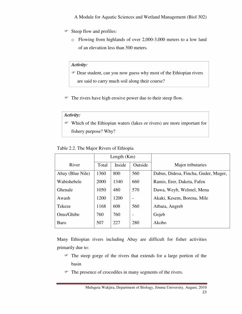
� Steep flow and profiles:
o Flowing from highlands of over 2,000-3,000 meters to a low land
of an elevation less than 500 meters.
Activity:
� Dear student, can you now guess why most of the Ethiopian rivers
are said to carry much soil along their course?
� The rivers have high erosive power due to their steep flow.
Activity:
� Which of the Ethiopian waters (lakes or rivers) are more important for
fishery purpose? Why?
Table 2.2. The Major Rivers of Ethiopia
River
Length (Km)
Major tributaries Total Inside Outside
Abay (Blue Nile)
Wabishebele
Ghenale
Awash
Tekeze
Omo/Ghibe
Baro
1360
2000
1050
1200
1168
760
507
800
1340
480
1200
608
760
227
560
660
570
-
560
-
280
Dabus, Didesa, Fincha, Guder, Muger,
Ramis, Erer, Daketa, Fafen
Dawa, Weyb, Welmel, Mena
Akaki, Kesem, Borena, Mile
Atbara, Angreb
Gojeb
Akobo
Many Ethiopian rivers including Abay are difficult for fisher activities
primarily due to:
� The steep gorge of the rivers that extends for a large portion of the
basin
� The presence of crocodiles in many segments of the rivers.

A Module for Aquatic Sciences and Wetland Management (Biol 302)
Mulugeta Wakjira, Department of Biology, Jimma University, August, 2010
24
� Moreover many of the tributaries dry or their volumes are highly
reduced during the dry seasons.
Activity:
� Dear student, in the above section under “the Ethiopian drainage systems”
we have mentioned about the flow pattern of the Ethiopian rivers found
within the three topographic regions. Please recall and write down the flow
patterns of the rivers.
The Ethiopian rivers generally flow into:
� Mediterranean Ocean: Which drainage system belongs here?
� Indian Ocean: Which drainage system belongs here?
� Close (inland) flow .i.e. with no external flow: Which drainage
system belongs here?
Activity:
� Dear student, why do you think that the Ethiopian rivers flow in the
pattern mentioned above?
The general flow pattern of Ethiopian rivers is determined by the topography
of the country:
� Western and South eastern highlands have an outward slopping
topography resulting in the out-ward flow of the rivers. Consequently
most major rivers of Ethiopian high lands cross the border and become
internationally significant.
o Baro-Akobo, Abay (Blue Nile) and Tekeze rivers drain west ward
into the Mediterranean Ocean.
o Ghenale and Wabi Shebele Rivers drain east ward into the Indian
Ocean.
� Rift Valley has an in ward slopping resulting mainly in an inland drainage
system.

A Module for Aquatic Sciences and Wetland Management (Biol 302)
Mulugeta Wakjira, Department of Biology, Jimma University, August, 2010
25
Activity:
1. How many countries contribute to the Nile River basin that crosses Sudan
and Egypt before draining into the Mediterranean Ocean? Can you name
the countries? (See chapter 7)
2. Among the Nile basin countries, Ethiopia is the major contributor to the
Nile River via its Abay (Blue Nile) River. How much percent of the total
water does Abay (Blue Nile) contribute to the Nile River?
3. What is the origin of White Nile and where does it confluence with the
Blue Nile (Abay) River to form the Nile River?
2.2.4. Wetlands
In Ethiopia wetlands are distributed all across the topographic unit of the
country ranging from the lowlands of salt lakes in the Afar depression to the
freshwater shallow lakes at Bale and Semen Mountains. They are estimated to
constitute 2% of the total area of the country.
Activity:
� What is the local name of a vegetation that is characteristic of most
wetlands in Ethiopia?
Swamps and marshes are the predominant forms often identified by reference
to a vegetation locally known as “cheffe”, which is the typical vegetation in
most wetlands. Marshes are periodically saturated, flooded, or opened with
water and characterized by herbaceous vegetation adapted to wet soil
conditions. Swamps are, however, fed primarily by surface water inputs and
are dominated by trees and shrubs. They are characterized by very wet soils
during the growing season and standing water during certain times of the year.
Activity:
� Do you think that wetlands are important? Think carefully of this question
before you pass on to read the following parts.
A Module for Aquatic Sciences and Wetland Management (Biol 302)
Mulugeta Wakjira, Department of Biology, Jimma University, August, 2010
26
Wetlands are most productive environments important in:
� Maintaining key ecological processes (reduce siltation, purifies water,
ground water recharge and discharge, etc)
� Supporting high biodiversity (such as waterfowl, mammals, reptiles,
amphibians, fish and invertebrate species, medicinal plan species)
� Providing socio-economic benefits to local communities
Activity:
Dear student, I hope that you can locate some wetlands in your area. What are
these wetlands used for by the local people? List them down.
In Ethiopia, the socio-economic benefits of wetlands include:
� Provision of clean water supplies throughout the year
� The wetland vegetation, such as “cheffe”, reeds, palms, bamboos and
papyrus, etc are harvested by the local people for roofing and making
of various crafts including boats.
� The other wetland plants, such as Hygrophila auriculata (locally
known as balanworanti) are used for medicinal purpose
� Most wetlands are used for cattle grazing and watering
� Wetlands are also used to cultivate maize and other edible plants
during dry season.

A Module for Aquatic Sciences and Wetland Management (Biol 302)
Mulugeta Wakjira, Department of Biology, Jimma University, August, 2010
27
Activity:
� Dear student, in the above section we have seen how wetlands are
important in nature and to human beings.
1. However, it is commonplace to see people draining and converting
wetlands into dry lands. What do you think should be done to preserve the
wetlands to ensure sustainability of their values and function? (Relate this
to a section on wetland management in chapter 7).
2. Some people associate wetlands to malaria transmission, a major killer
disease in the world. Do you think that is true? How?
3. Are you in favour of or against the idea of the need for the proper
management of wetlands? Should they be kept or avoided? Explain.

A Module for Aquatic Sciences and Wetland Management (Biol 302)
Mulugeta Wakjira, Department of Biology, Jimma University, August, 2010
28
� Chapter Review Questions
Answer the following questions properly. Refer to the appropriate sections to
confirm your answers
1. What is catchment or drainage basin?
2. List down the seven Ethiopian drainage basins.
3. Categorize the Ethiopian drainage basins into their respective
topographic regions. What are the three Ethiopian drainage
topographic regions?
4. Give examples of rivers and lakes located in each basin
5. Which of the Ethiopian lakes and rivers are mainly important in
fisheries?
6. What are the differences between the endorheic and exorheic drainage
basins?
7. Which of the Ethiopian drainage basins are endorheic? Exorheic?
8. What is watershed? Give examples
9. List down the various catchment characteristics that can affect the
various aspects of a water body located in a giver drainage basin.
10. What are the characteristics of Ethiopian rivers in terms of the amount
of water and flow pattern?
11. Why are the Ethiopian rivers said to be highly erosive?
12. Which wetland types are much common in Ethiopia?
13. What the various ecological functions of wetlands? Their socio-
economic functions?
A Module for Aquatic Sciences and Wetland Management (Biol 302)
Mulugeta Wakjira, Department of Biology, Jimma University, August, 2010
29
Chapter 3. Ecology of Aquatic Ecosystems
Chapter Objectives:
At the end of this chapter you will be able to:
� Describe about zonations in aquatic ecosystems
� Distinguish between the autochthonous and allochtonous inputs of the
aquatic environments
� Discuss about the community structure and functional feeding groups
in aquatic ecosystems
� Discuss the ecology of marine and freshwater ecosystems
3.1. Zonations in Aquatic Ecosystems
3.1.1. Zonations in Freshwater Ecosystems
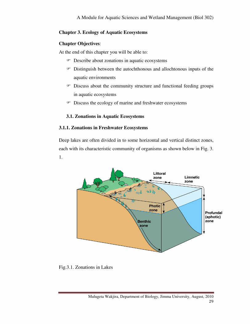
Deep lakes are often divided in to some horizontal and vertical distinct zones,
each with its characteristic community of organisms as shown below in Fig. 3.
1.
Fig.3.1. Zonations in Lakes
A Module for Aquatic Sciences and Wetland Management (Biol 302)
Mulugeta Wakjira, Department of Biology, Jimma University, August, 2010
30
The littoral zone is shallow, well-lighted, warm water close to shore
characterised by the presence of rooted and floating vegetation, a diverse
attached algae community, and a very diverse animal fauna including
suspension feeders (e.g. clams), herbivorous grazers (e.g. snails), and
herbivorous and carnivorous insects, crustaceans, fishes, amphibians, some
reptiles, waterfowl, and mammals.
Photic (euphotic) zone is the upper layer in the limnetic zone where light is
sufficient enough for the rate of photosynthesis to exceed the rate of
respiration. Aphotic (dark) zone is the lower zone that receives little or no
light, due to the absorption of light attenuation in the upper water column, and
no photosynthesis occurs.
The limnetic zone is the open, well-lighted waters away from the shore
occupied by phytoplankton (algae and cyanobacteria) which are
photosynthetic, zooplankton (rotifers and small crustaceans) that grazes on
phytoplankton, and small fish that feed on the zooplankton. Occasionally large
fish, turtles, snakes, and piscivorous birds are also seen in this zone.
The profundal zone is the deep, aphotic zone lying beneath the limnetic zone
where water temperature is usually cold. This is an area of decomposition
where detritus is broken down; thus oxygen is low and mineral nutrients are
usually plentiful due to cellular respiration of decomposers. Waters of the
profundal zone usually do not mix with surface waters because of density
differences related to temperature. Mixing of these layers usually occurs twice
each year in temperate lakes and ponds; this results in oxygen entering the
profundal zone and nutrients being cycled into the limnetic zone.
Activity:
� Dear student, can you now enumerate the differences among the littoral,
limnetic and profundal zones of a lake?
A Module for Aquatic Sciences and Wetland Management (Biol 302)
Mulugeta Wakjira, Department of Biology, Jimma University, August, 2010
31
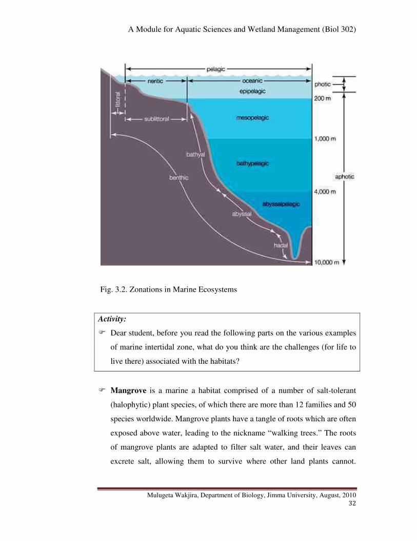
3.1.2. Zonations in Marine Ecosystems
Marine ecosystems can be divided into various horizontal and vertical zones
such as intertidal (littoral), neritic, oceanic, etc as described below.
Activity:
� Dear student, in which of the two aquatic ecosystems (lake or marine) do
you expect more zonations? Why? How do the lake zones compare and
contrast with those of marine ecosystem (oceans and seas)?
A photic (also known as euphotic) zone is present and extends to the depth at
which light penetration supports photosynthesis; occupied by phytoplankton,
zooplankton and many fish species. The aphotic (dark) zone is below the
level of effective light penetration and represents a majority of the ocean's
volume. The intertidal zone is the shallow zone where the terrestrial habitat
meets the ocean's water. The neritic zone extends from the intertidal zone,
across the shallow regions, to the edge of the continental shelf. Oceanic zones
extend over deep water from one continental shelf to another. Pelagic zones
refer to open waters of any depth. Benthic zones refer to the seafloor.
Intertidal (littoral) zone is a shore area between high and low tides.
Consequently, organisms inhabiting this zone have adaptations that enable
them to survive periodic exposure to the air and wave action. Examples of
habitats occurring in this zone include mangrove swamps, seagrasses, coral
reefs and sandy beaches. These habitats all come with their unique challenges
and are inhabited by a wide variety of organisms and some of these regions
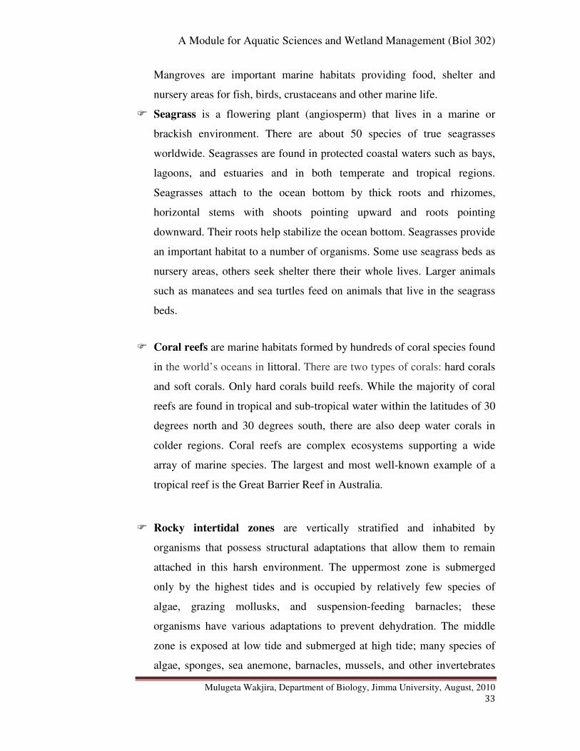
are quite productive as described below. These include Mangrove, Sea grass,
Coral reefs, Rocky inter tidal zones.
A Module for Aquatic Sciences and Wetland Management (Biol 302)
Mulugeta Wakjira, Department of Biology, Jimma University, August, 2010
32
Fig. 3.2. Zonations in Marine Ecosystems
Activity:
� Dear student, before you read the following parts on the various examples
of marine intertidal zone, what do you think are the challenges (for life to
live there) associated with the habitats?
� Mangrove is a marine a habitat comprised of a number of salt-tolerant
(halophytic) plant species, of which there are more than 12 families and 50
species worldwide. Mangrove plants have a tangle of roots which are often
exposed above water, leading to the nickname “walking trees.” The roots
of mangrove plants are adapted to filter salt water, and their leaves can
excrete salt, allowing them to survive where other land plants cannot.
A Module for Aquatic Sciences and Wetland Management (Biol 302)
Mulugeta Wakjira, Department of Biology, Jimma University, August, 2010
33
Mangroves are important marine habitats providing food, shelter and
nursery areas for fish, birds, crustaceans and other marine life.
� Seagrass is a flowering plant (angiosperm) that lives in a marine or
brackish environment. There are about 50 species of true seagrasses
worldwide. Seagrasses are found in protected coastal waters such as bays,
lagoons, and estuaries and in both temperate and tropical regions.
Seagrasses attach to the ocean bottom by thick roots and rhizomes,
horizontal stems with shoots pointing upward and roots pointing
downward. Their roots help stabilize the ocean bottom. Seagrasses provide
an important habitat to a number of organisms. Some use seagrass beds as
nursery areas, others seek shelter there their whole lives. Larger animals
such as manatees and sea turtles feed on animals that live in the seagrass
beds.
� Coral reefs are marine habitats formed by hundreds of coral species found
in the world’s oceans in littoral. There are two types of corals: hard corals
and soft corals. Only hard corals build reefs. While the majority of coral
reefs are found in tropical and sub-tropical water within the latitudes of 30
degrees north and 30 degrees south, there are also deep water corals in
colder regions. Coral reefs are complex ecosystems supporting a wide
array of marine species. The largest and most well-known example of a
tropical reef is the Great Barrier Reef in Australia.
� Rocky intertidal zones are vertically stratified and inhabited by
organisms that possess structural adaptations that allow them to remain
attached in this harsh environment. The uppermost zone is submerged
only by the highest tides and is occupied by relatively few species of
algae, grazing mollusks, and suspension-feeding barnacles; these
organisms have various adaptations to prevent dehydration. The middle
zone is exposed at low tide and submerged at high tide; many species of
algae, sponges, sea anemone, barnacles, mussels, and other invertebrates
A Module for Aquatic Sciences and Wetland Management (Biol 302)
Mulugeta Wakjira, Department of Biology, Jimma University, August, 2010
34
are found in this area. The diversity is greater here due to the longer time
spans this area is submerged. Tide pools are often found in the middle
zone. These are depressions which are covered during high tide and
remain as pools during low tide; tidepool organisms face dramatic salinity
increases as water evaporates at low tide. The low intertidal zone is
exposed only during the lowest tides and shows the greatest diversity of
invertebrates, fishes and seaweeds.
Neritic zone is the relatively shallow part of ocean that extends to the edge of
the continental shelf. Primary productivity here depends on planktonic algae
growing as deep as the light can reach.
Oceanic zone (pelagic) is the open part of an ocean located over the ocean
basins extending from one edge of continental shelf to the next. In this zone
despite its diversity of life, primary productivity is much limited to the depths
that light can reach. The producers are planktonic algae that support secondary
and higher consumers (e.g., fish) in the nekton.
Abyssal plain is the bottom of the ocean basins which is relatively unvarying
region largely inhabited by sparse populations of bottom-dwelling organisms
that make up the benthos. These are consumers and decomposers which
depend on the organic matter drifting down from the upper portions of the sea.
The Benthic zone (deep sea) includes the deepest, darkest, coldest parts of
the ocean. In this zone are found unique habitats namely the hydrothermal
vents that remained unknown until about 30 years ago, when they were
discovered in the submersible Alvin. Hydrothermal vents are found at an
average depth of about 7,000 feet and are essentially underwater geysers
created as a result of cracks in the ocean floor due to the movement of plate
tectonics. Ocean water enters these cracks, is heated up by the Earth’s magma,
and then released through the hydrothermal vents, along with minerals such as
hydrogen sulfide. The water coming out of the vents can reach incredible

A Module for Aquatic Sciences and Wetland Management (Biol 302)
Mulugeta Wakjira, Department of Biology, Jimma University, August, 2010
35
temperatures of up to 750 degrees F. Despite their threatening description,
hundreds of species of marine life thrive in this habitat.
3.2. Autochotonus and Allochtonous Inputs
Autochthonous inputs refer to the organic production within the water body
as a function of the primary producers such as phytoplankton. This is the
major source of organic supply to the life in the aquatic habitats. On the other
hand allochtonous input refers to organic materials (such as leaves, branches
and dead bodies) washed into the system. Allochtonous inputs provide an
important food source, especially where dense vegetation along the shore
blocks out sunlight or high turbidity prevents light penetration.
3.3. Community Structure
Classes of organisms found in aquatic ecosystems can be categorized as
plankton, nektons and benthos.
Activity:
� Dear student, can you please write down the differences among these three
categories of aquatic organisms and give example to each?
3.3.1. Plankton community
The term plankton is derived from the Greek word “planktos”, meaning
“drifter" to indicate their movement which is largely dependent on water
currents. Plankton are any drifting organisms including animals, plants or
bacteria that inhabit the pelagic zone of aquatic ecosystems. While some
forms are capable of independent movement and can swim hundreds of meters
vertically in a single day (Diel Vertical Migration), their horizontal position is
primarily determined by the surrounding water currents. They provide a
crucial source of food to larger aquatic organisms such as fish. Moreover, they
A Module for Aquatic Sciences and Wetland Management (Biol 302)
Mulugeta Wakjira, Department of Biology, Jimma University, August, 2010
36
are important in the biogeochemical cycles of many important chemical
elements including carbon.
Activity:
� Dear student, plankton can be categorized as transient and permanent
plankton. What does this mean?
In a plankton community two forms can be recognized: holoplankton and
meroplakton. Plankton such as most algae, copepods, salps and jelly fish
spending their entire life as plankton are termed as holoplankton. In contrast,
those which are planktic only for part of their lives, such as the larval stages of
fish, crustaceans, starfish, etc, are known as meroplankton.
Activity:
1. To which of the plankton categories (Meroplankton or Holoplankton) do
the terms transient and permanent refer?
2. In aquatic environments, what factors do you think may determine the
abundance and distribution of plankton?
Plankton abundance and distribution are strongly dependent on factors such as
ambient nutrients concentrations, the physical state of the water column, and
the abundance of other plankton. Local abundance varies horizontally,
vertically and seasonally primarily because of the availability of light.
Activity:
� Dear student, what do the terms horizontal and vertical refer to in the
abundance and distribution of plankton?
The term “vertical” refers to variation at different points along the depth (i.e.
from top to bottom or bottom to up) and “horizontal” refers to variation along
the length or the width of the water body.
A Module for Aquatic Sciences and Wetland Management (Biol 302)
Mulugeta Wakjira, Department of Biology, Jimma University, August, 2010
37
All plankton ecosystems are driven by the input of solar energy (except the
chemosynthetic forms), confining primary production to surface waters, and
to geographical regions and seasons having abundant light. A secondary
variable is nutrient availability. For example, although large areas of the
tropical and sub-tropical oceans have abundant light, they experience
relatively low primary production because they offer limited nutrients such as
nitrate, phosphate and silicate resulting from large-scale ocean circulation and
water column stratification.
� Trophic Groups of Plankton
Plankton can be divided into some functional or trophic level groups.
Activity:
Dear student,
1. What do we mean by functional or trophic level groups of plankton?
2. Plankton can be broadly classified in to producer plankton and
heterotrophic (consumers and decomposer/recycler) plankton. Please
define each group before you pass on to read the following section.
Producer plankton are those capable of transforming inorganic nutrients
(CO2 and O2) into organic materials (e.g. carbohydrates) using either sunlight
(photosynthetic plankton) or chemical energy (chemosynthetic plankton).
These are therefore the primary producers in aquatic environments, which are
equivalent to the “green plants” in terrestrial ecosystems. On the other hand,
heterotrophic plankton are those which are not capable of converting
inorganic substances into organic substances. The heterotrophic plankton can
be either consumer or decomposer (recyclers).
These major plankton categories (i.e. autotrophic and heterotrophic) are
divided into functional or trophic level groups though the determination for
some plankton may not be straightforward. For example, although most

A Module for Aquatic Sciences and Wetland Management (Biol 302)
Mulugeta Wakjira, Department of Biology, Jimma University, August, 2010
38
dinoflagellates are photosynthetic producers or heterotrophic consumers,
many species are mixotrophic (i.e. both photosynthetic and heterotrophic)
depending upon circumstances. The following are the major categories of
plankton: Phytoplankton, Zooplankton and Bacterioplankton.
� Phytoplankton (from Greek phyton, or plant), autotrophic, prokaryotic or
eukaryotic algae that live near the water surface where there is sufficient
light to support photosynthesis. Among the more important groups are the
diatoms, cyanobacteria, dinoflagellates and cocolithophores. Dear
student, you have to remember much about algae from your
Phycology course.
� Zooplankton (from Greek zoon, which means animal), small protozoans
or metazoans (e.g. crustaceans and rotifers) that feed on other plankton.
Eggs and larvae of some of the larger animals such as fish, crustaceans,
and annelids are included here. Zooplankton are the initial prey item for
almost all fish larvae as they switch from their yolk sacs to external
feeding. Fish rely on the density and distribution of zooplankton to match
that of new larvae, which can otherwise starve. Natural factors (e.g.,
current variations) and man-made factors (e.g. river dams) can strongly
affect zooplankton, which can in turn strongly affect larval survival, and
therefore fish breeding success.
� Bacterioplankton are bacteria and archaea which play an important role
in remineralizing organic material down the water column.
Activity:
� Dear student, please categorize each of the above trophic groups of
plankton (phytoplankton, zooplankton and bacterioplankton) as primary
producer, consumer or decomposer. Explain your answer.
A Module for Aquatic Sciences and Wetland Management (Biol 302)
Mulugeta Wakjira, Department of Biology, Jimma University, August, 2010
39
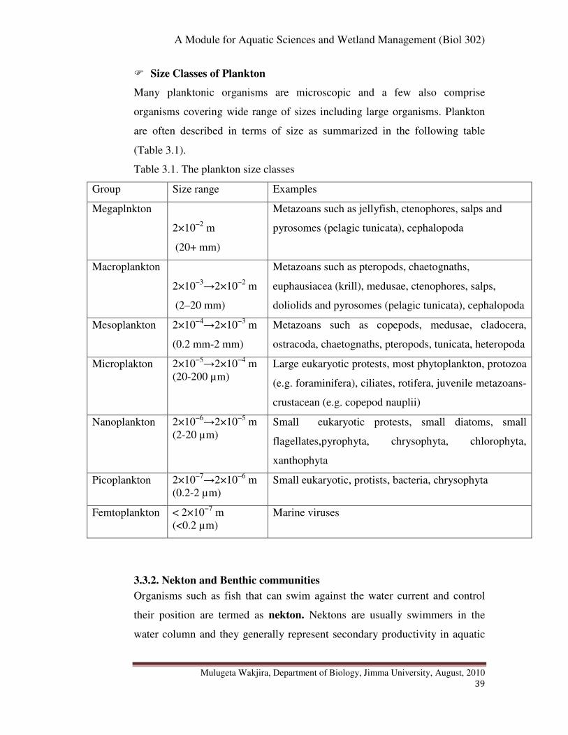
� Size Classes of Plankton
Many planktonic organisms are microscopic and a few also comprise
organisms covering wide range of sizes including large organisms. Plankton
are often described in terms of size as summarized in the following table
(Table 3.1).
Table 3.1. The plankton size classes
Group Size range Examples
Megaplnkton
2×10⁻²
m
(20+ mm)
Metazoans such as jellyfish, ctenophores, salps and
pyrosomes (pelagic tunicata), cephalopoda
Macroplankton
2×10⁻³→2×10
−2 m
(2–20 mm)
Metazoans such as pteropods, chaetognaths,
euphausiacea (krill), medusae, ctenophores, salps,
doliolids and pyrosomes (pelagic tunicata), cephalopoda
Mesoplankton 2×10⁻⁴→2×10
−3 m
(0.2 mm-2 mm)
Metazoans such as copepods, medusae, cladocera,
ostracoda, chaetognaths, pteropods, tunicata, heteropoda
Microplakton 2×10⁻⁵→2×10
−4 m
(20-200 µm)
Large eukaryotic protests, most phytoplankton, protozoa
(e.g. foraminifera), ciliates, rotifera, juvenile metazoans-
crustacean (e.g. copepod nauplii)
Nanoplankton 2×10⁻⁶→2×10
−5 m
(2-20 µm)
Small eukaryotic protests, small diatoms, small
flagellates,pyrophyta, chrysophyta, chlorophyta,
xanthophyta
Picoplankton 2×10⁻⁷→2×10
−6 m
(0.2-2 µm)
Small eukaryotic, protists, bacteria, chrysophyta
Femtoplankton < 2×10⁻⁷
m
(<0.2 µm)
Marine viruses
3.3.2. Nekton and Benthic communities
Organisms such as fish that can swim against the water current and control
their position are termed as nekton. Nektons are usually swimmers in the
water column and they generally represent secondary productivity in aquatic
A Module for Aquatic Sciences and Wetland Management (Biol 302)
Mulugeta Wakjira, Department of Biology, Jimma University, August, 2010
40
ecosystems. On the other hand benthos are those organisms inhabiting the
bottom of the aquatic habitat.
3.4. Aquatic Ecology
3.4.1. Abiotic Components
Abiotic factors such as temperature, precipitation, and light influence the
distribution of organisms. The patchiness of the global biosphere illustrates
how the different physical environments produce a mosaic of habitats. Some
of the important abiotic factors that affect distribution of species have been
described in section 1.2. in chapter 1.
3.4.2. Functional Feeding Groups
� Autotrophic Groups
Autotrophic organisms are producers that generate organic compounds from
inorganic materials. These are largely phytoplankton (algae) that use solar or
chemical energy to generate biomass from carbon dioxide. Photosynthetic
organisms are the major autotrophs in aquatic ecosystems whereas
chemosynthetic organisms (e.g. some bacteria) are largely benthic in aquatic
ecosystems.
Activity:
� Dear student, above we have seen that phytoplankton are largely the
primary producers in aquatic ecosystems. Do you think that these are the
only primary producers in aquatic ecosystems?
Aquatic rooted plants such as weeds and also some bacteria (photosynthetic
and chemosynthetic bacteria) also contribute to aquatic primary production.
� Heterotrophic Groups
Heterotrophic organisms derive their organic nutrient need from autotrophic
organisms either as consumers or decomposers. Consumers are largely
A Module for Aquatic Sciences and Wetland Management (Biol 302)
Mulugeta Wakjira, Department of Biology, Jimma University, August, 2010
41
zooplankton and nektons such as fish whereas decomposers include some
bacteria.
Activity:
� Dear student, what are the various trophic categories of bacteria in aquatic
ecosystems from what we have discussed so far in relation to the trophic
groups.
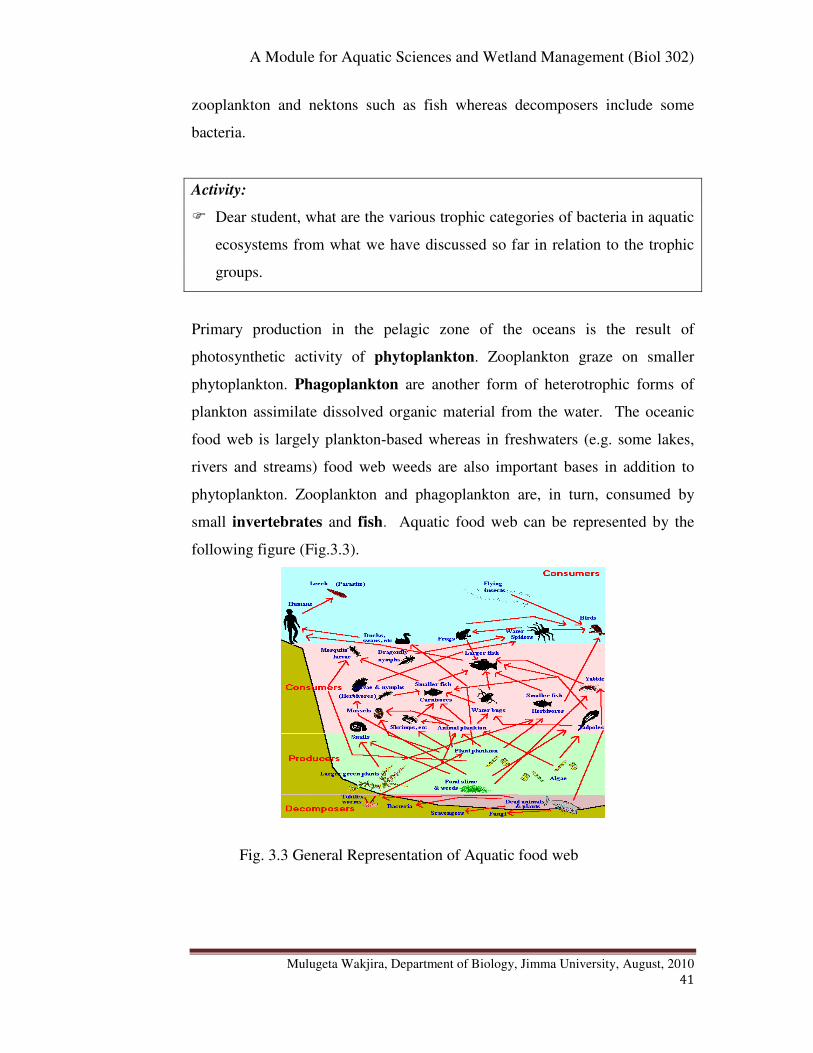
Primary production in the pelagic zone of the oceans is the result of
photosynthetic activity of phytoplankton. Zooplankton graze on smaller
phytoplankton. Phagoplankton are another form of heterotrophic forms of
plankton assimilate dissolved organic material from the water. The oceanic
food web is largely plankton-based whereas in freshwaters (e.g. some lakes,
rivers and streams) food web weeds are also important bases in addition to
phytoplankton. Zooplankton and phagoplankton are, in turn, consumed by
small invertebrates and fish. Aquatic food web can be represented by the
following figure (Fig.3.3).
Fig. 3.3 General Representation of Aquatic food web
A Module for Aquatic Sciences and Wetland Management (Biol 302)
Mulugeta Wakjira, Department of Biology, Jimma University, August, 2010
42
� Chapter Review Questions
Answer the following questions properly. Refer to the appropriate sections to
confirm your answers
1. Define each of the following terms in relation to zonations in lakes:
(Littoral, Limnetic, Profundal, Euphotic (Photic), Aphotic)
2. Define the following terms in relation to zonations in marine habitats
(Littoral, Intertidal, Oceanic, Pelagic, Euphotic, Aphotic, Abyssal
plain, Benthic)
3. Give examples marine littoral marine habitats. Briefly describe each of
these habitats.
4. What is the difference between autochtonous and allochtonous inputs
in aquatic ecosystems? Give examples for each.
5. What are plankton, neckton and benthos in aquatic ecosystems?
6. What are the differences between holoplankton and meroplankton?
Give examples
7. What are the differences among producer, consumer and decomposer
plankton? Give examples for each?
8. What are the differences between photosynthesis and chemosynthesis?
Give examples of organisms carrying out each activity.
9. Distinguish between Zooplankton, Phagoplankton, Phtoplankton and
Bactrioplankton with their functions and examples.
10. List down the seven size classes of plankton described in the chapter
with at least on example
11. What are the major primary producers in aquatic ecosystems?
Phytoplankton or rooted aquatic plants?
12. In which of the aquatic ecosystems (Oceans, lakes or rivers) are the
rooted aquatic plants more important as primary producers?
13. What are factors that can affect the abundance and distribution of
plankton in aquatic ecosystems?
A Module for Aquatic Sciences and Wetland Management (Biol 302)
Mulugeta Wakjira, Department of Biology, Jimma University, August, 2010
43
Chapter 4: Water Pollution
Chapter Objectives:
At the end of this chapter you will be able to:
� Define water pollution
� Distinguish between point and diffuse source pollutions of water
� Distinguish between the surface and ground waters
� List down the various examples of aquatic pollutants
� Explain the impacts or effects of the various types of pollutants to the
aquatic environments
� Explain how forests affect water quality and quantity
4.1. What is Water Pollution?
Activity:
� When do you think that water is said to be polluted? Write down your
answer on a small piece of paper.
There exist various definitions of water pollution. Some, for instance, define
water pollution as: “the introduction by man, directly or indirectly, of
substances or energy into the aquatic environments resulting in such
deleterious effects as harm to living resources, hazards to human health,
hindrance to aquatic activities, including fishing, impairment of water quality
with respect to its use in agriculture, and often economic uses”.
Others define water pollution as a “state resulting when substances are
released into a body of water, where they become dissolved or suspended in
the water or deposited on the bottom, accumulating to the extent that they
overwhelm its capacity to absorb, break down, or recycle them, and thus
interfering with the functioning of aquatic ecosystems”.
A Module for Aquatic Sciences and Wetland Management (Biol 302)
Mulugeta Wakjira, Department of Biology, Jimma University, August, 2010
44
Activities:
1. What is surface water? Give some examples.
2. What is groundwater?
3. Does water pollution refer only to surface water or to both?
Given the various ways of defining water pollution, it, however, refers to the
contamination of both the surface water and groundwater. Surface water
includes the visible water resources, such as oceans, rivers and lakes, that are
found on the exterior of the earth's crust. Groundwater, however, is a water
resource found underground in rock structures called aquifers. Groundwater is
important for recharge of surface waters and supplies much of drinking water.
Though groundwater pollution is much less obvious than surface-water
pollution, but is no less of a problem. Surface water resources are more
vulnerable to pollution. Moreover, factors that lead to surface water pollution
may not lead to groundwater pollution and vice versa. Also the management
of groundwater pollution is more difficult.
4.2. Sources of Water Pollution
Activity:
� Can you list down the various possible sources that can cause water
pollution?
Water pollution can occur due to natural or anthropogenic (i.e. human
induced) factors. Natural factors such as dissolution of rocks and evaporation
lead to increased salinity and introduction of heavy metals such as Pb, Hg, Cd
and As. The high fluoride content in drinking water leads to conditions such
as dental and bone fluorosis whereas the heavy metals are toxic both to human
and the environment in various ways.
A Module for Aquatic Sciences and Wetland Management (Biol 302)
Mulugeta Wakjira, Department of Biology, Jimma University, August, 2010
45
Industrialization and agricultural activities amalgamated with an alarmingly
increasing human population are among the anthropogenic factors that
significantly contribute to water pollution. According to the World Population
Prospects (2008) the current (2010 G.C.) human population is estimated to be
nearly 7 billion, which is projected to reach 9 billion by 2050. At present
water pollution is becoming such a serious problem in that every continent,
from the tropics to the once-pristine polar regions, is getting contaminated.
The human induced water pollution comes from a number of different
sources. If the pollution is from a single source, such as an oil spill or a
factory discharging its waste through a pipe into a water body, it is called
point-source pollution. On the other hand, if the pollution is caused from
many sources, it is called nonpoint-source (diffuse) pollution. Point-source
pollution often affects the area immediately around the source. For example,
when a tanker accident occurs, the oil spill is concentrated around the tanker
itself. This is, however, less likely to happen with nonpoint source pollution
since the pollutants enter the environment from many different places.
Sometimes pollutions, such as nuclear or radioactive waste, may affect the
environment hundreds of miles away from the source; this is called
transboundary pollution.
4.3. Types of Water Pollutions and the Contaminants
A particular pollution source usually produces a mix of water pollutants. For
instance, a wastes originating from industries could consist of chemicals such
as heavy metals, oils, microorganisms, etc. Moreover, a given pollutant could
come from more than one type of pollution sources. However, for the sake of
simplicity we categorize types of water pollutions and the major contaminants
as presented below.
A Module for Aquatic Sciences and Wetland Management (Biol 302)
Mulugeta Wakjira, Department of Biology, Jimma University, August, 2010
46
1. Domestic and Industrial Pollution
Domestic activities such as washing and toilet flushing, and industrial
activities such as manufacturing processes in industries produce a wastewater
that contains waste products collectively known as sewage. Sewage is thus a
water-carried waste, in either solution or suspension, that is intended to flow
away from a community. Wastewater is largely pure water and is
characterized by its volume or rate of flow, its physical condition, its chemical
constituents, and the bacteriological organisms that it contains.
Activity:
� Take a moment and think of what various materials sewage is composed
of. Please list down some of them.
Sewage practically contains various types of substances including the
pharmaceutical drugs, papers, plastics, and other wastes humans flush down
their toilets and factories. Moreover, it often carries harmful micro-organisms
such as viruses and bacteria into the environment causing health problems
such as hepatitis, typhoid, and cholera. Sewage especially from industries may
also contain chemicals such as heavy metals including lead and mercury that
are harmful to the health of many animals, including humans. Heavy metals
draw attention in that their concentration increases high up in food chain, a
condition known as bioaccumulation or bioamplification. The effect of heavy
metals is thus highly pronounced at higher trophic levels such as in human
being.
Activity:
� How do you think that sewage could be properly disposed in such a way
that it may not cause serious water pollution?
A Module for Aquatic Sciences and Wetland Management (Biol 302)
Mulugeta Wakjira, Department of Biology, Jimma University, August, 2010
47
If suitably treated and used in moderate quantities, sewage can be a fertilizer:
it returns important nutrients to the environment, such as nitrogen and
phosphorus, which plants and animals need for growth. The trouble is, sewage
is often released in much greater quantities than the natural environment can
cope with. Untreated sewage can contaminate the environment and cause
diseases such as diarrhea.
Sewage management or disposal is a major problem in developing countries
as access to sanitary conditions and clean water in these areas is scarce.
Sewage in developed countries is carried away from the home quickly and
hygienically through sewage pipes to be treated in water treatment plants and
ultimately disposed into the aquatic environments. However, the dumping of
sewage into seas and oceans still remains a serious environmental problem
especially in developed countries.
2. Agricultural Pollution
Agricultural activities cause the pollution of water through the addition of
pesticides, herbicides and nutrients with surface run-offs as described below.
Pesticides and Herbicides
Pesticides and herbicides are chemicals that are used in farming to control
insects, weeds and fungi. These chemicals enter water bodies with run-offs
causing poisoning of aquatic life such as fish. Subsequently, birds, humans
and other animals may be poisoned if they eat infected fish. The high concern
with these chemicals is that, similar to the heavy metals, tend to bioaccumlate
in nature.
Nutrients
Chemical fertilizers used by farmers add nutrients such as nitrogen (in the
form of nitrates) and phosphorus (in the form of phosphates) to the soil which
A Module for Aquatic Sciences and Wetland Management (Biol 302)
Mulugeta Wakjira, Department of Biology, Jimma University, August, 2010
48
when run-off into nearby lakes, rivers, or oceans cause an increase in nutrient
levels of the water bodies. Nutrients are basically essential for plant growth
and development. However, the excessively high nutrient enrichment of the
water bodies causes a massive increase in the growth or bloom of algae or
plankton, leading to a condition known as eutrophication. Eutrophication can
be a problem to the aquatic habitats in various ways.
Activity:
� Dear student, before you pass on to read the following part, please take out
a piece of paper and try to write down a few points about the effects of
eutrophication in aquatic habitats.
Excessive algal bloom or eutrophication disrupts normal ecosystem
functioning and causes many problems. The following are some of the effects
of eutrophication in water bodies:
� Excessive weed and algae growth in water can cause a contamination of
drinking water and clog filters.
� The algae may use up all the oxygen in the water, leaving none for other
aquatic life. Moreover, microorganisms can cause oxygen depletion when
decomposing the dead algal body. This in turn results in the death of many
aquatic organisms such as fish, which need oxygen in the water to live.
� The bloom of algae may also block sunlight from photosynthetic aquatic
plants found at lower depth. Sunlight blocking also has an effect on visual
dependent predators living at relatively lower depths.
� Some algae produce toxins that are harmful to higher forms of life. This
can cause problems along the food chain and affect any animal that feeds
on them. Birds and humans can get poisoned and even die when feed on
poisoned fish.

A Module for Aquatic Sciences and Wetland Management (Biol 302)
Mulugeta Wakjira, Department of Biology, Jimma University, August, 2010
49
It is important to bear in mind, however, that eutrophication is basically a
natural process that can develop because of the vertical mixing of the water
bodies (which upwells nutrients from the bottom) and with the ageing of the
water bodies, often leading to high aquatic productivity including high fish
production. It becomes catastrophic when accelerated because of the human
induced activities.
3. Oil Pollution
Activity:
� Oil pollution is a major concern in marine waters such as oceans than in
inland water bodies. Why?
Oil pollution is caused by oil spills from tankers, shipping, dumping from
factories and surface run-offs. However, the latter three factors account for the
larger proportion of oil pollution. Oil spills cause a localised problem but can
be catastrophic to local aquatic wildlife such as fish and aquatic birds. Oil
cannot dissolve in water and thus forms a thick layer in the water. It
consequently suffocates fish, gets caught in the feathers of marine birds
stopping them from flying and blocks light from photosynthetic aquatic
plants.
4. Atmospheric Deposition
Atmospheric deposition is the pollution of water caused by air. Anthropogenic
activities such as coal mining and smelting of ores (e.g. sulfide) cause the
pollution of air with products that would subsequently lead to the formation of
acids such as sulfuric acids, carbonic acids and nitric acids as shown in the
chemical reaction below. These acids will reach into the aquatic environments
with the rain, called acid rain.
2FeS2+7O2+H2O 2FeSO4+ 2H2SO4
A Module for Aquatic Sciences and Wetland Management (Biol 302)
Mulugeta Wakjira, Department of Biology, Jimma University, August, 2010
50
Activity:
� When acid rain pollutes aquatic habitats such as rivers and lakes, aquatic
life is harmed. Write down the effects.
It is important to note that human activities can also cause direct acidification
such as through addition of battery acid in to water bodies. Acidification of
aquatic environments has a sterilizing effect on water as fishes become too
weak to survive, and lose their capacity to reproduce normally.
5. Thermal Pollution
This is an increase in water temperature as a result of discharge of hot
effluents from sources such as factories and power plants into the water
bodies especially into the rivers or naturally caused by global warming.
Global warming is a process where the average global temperature increases
due to the greenhouse effect. The burning of fossil fuel releases greenhouse
gasses, such as carbon dioxide, into the atmosphere causing heat from the sun
to get ‘trapped’ in the earth’s atmosphere and consequently the global
temperature rises.
Activity:
� What measures do you think should be taken in order to revert the current
situation of rising global warming?
An increase in water temperature can result in the death of many aquatic
organisms and disrupt many aquatic habitats. For example, it can cause
bleaching of coral reefs around the world. Coral reef bleaching is when the
coral expels the microorganisms of which it is dependent on. This can result in
great damage to coral reefs and subsequently, all the marine life that depends
on it. Moreover, it reduces the amount of dissolved oxygen in the water, thus
also reducing the level of aquatic life that the aquatic environment can support
including fish.
A Module for Aquatic Sciences and Wetland Management (Biol 302)
Mulugeta Wakjira, Department of Biology, Jimma University, August, 2010
51
6. Suspended Matter Pollution
Suspended matter in water bodies basically consists of clay, silt, sand, organic
compounds, plankton and other microscopic organisms. Such particles vary in
size from approximately 10 nm in diameter to 0.1 mm in diameter, although it
is usually accepted that suspended matter is the fraction that will not pass
through a pore diameter size of 0.45 µm filter.
Activities:
1. Please take a moment, think of, and try to write down the origin of
suspended matters and how they reach water bodies.
2. What do you think are the possible effects of suspended matter in aquatic
habitats?
Suspended matter often originates from surface of the catchment area, eroded
from river banks, lake or ocean shores and resuspended from the bed of the
water body. Suspended matter can be detrimental to the aquatic environments
in various ways. For instance,
� Suspended matter may be responsible for transporting pollutants such
as heavy metals.
� The suspended matter causes the water to become cloudy limiting the
depth of sunlight penetration. This hampers aquatic photosynthesis
which in turn can disrupt the functioning of the whole aquatic
ecosystem.
� The suspended particles can cause siltation at the bottom which is
harmful to the benthic aquatic life.
� Toxic chemicals suspended in water can be harmful to the
development and survival of aquatic life.
A Module for Aquatic Sciences and Wetland Management (Biol 302)
Mulugeta Wakjira, Department of Biology, Jimma University, August, 2010
52
Activities:
1. What do you think can be the mitigation measures for reducing suspended
matter loading into the aquatic environments from the catchment areas?
2. Can you explain the roles of aforestation and reforestation in this regard?
When land is cleared of forests, it not only destroys the habitat, but also it can
affect the area in other ways. The cleared land becomes exposed, without
roots of plants to hold on to the soil, wind and rain will move large amounts of
soil from the ground into water bodies, polluting the water.
7. Radioactive wastes pollution
The radioactive (nuclear) wastes largely originate from developed countries
and carried around the world when dumped into the sea. The following are
some of the major sources of nuclear (radioactive) wastes:
� Nuclear-fuel reprocessing plants such as in northern Europe (England
& France) are the biggest sources of man-made nuclear wastes in the
surrounding ocean. Radioactive wastes from these plants have been
reported to pollute the down stream countries such as Norway and
Ireland. Reports also indicate that traces of radioactive pollution have
been found as far away as Greenland.
� Mining and refining of uranium and thorium are also causes of marine
nuclear wastes.
� Radioactive wastes are also produced in the nuclear fuel cycle which is
used in many industrial, medical and scientific processes.
Activity:
� Dear student, radioactive wastes are often watched out with great alarm.
Why do you think that it is so?
Nuclear wastes can have serious detrimental effects on aquatic habitats
especially the marine habitats which are the main targets. They can cause

A Module for Aquatic Sciences and Wetland Management (Biol 302)
Mulugeta Wakjira, Department of Biology, Jimma University, August, 2010
53
cancer and other diseases at lower concentrations and death at higher
concentrations. Nuclear wastes can also be threat to the groundwater when
injected deep into the earth as an alternative way of dumping them.
8. Alien (exotic) species
Most of the time our perception of water pollution involves things like
sewage, toxic metals, or oil spill etc described above from 1 to 7 under section
5.3. However, the introduction of alien species into a given water body can
cause a serious problem both on the organisms naturally living in that water
body and the aquatic habitats. Alien species (sometimes known as invasive
species) are animals or plants from one region that have been introduced into
a different ecosystem where they do not belong. Outside their normal
environment, they have no natural predators, so they rapidly run wild,
crowding out the usual animals or plants that thrive there. Alien invaders can
cause economic loss when they affect the aquatic habitat or its biota.
A fish known as common carp has been introduced to some of the Ethiopian
waters but are generally described invasive in most of the countries.
Activity
� Can you give more examples of alien species in water bodies with
explanation of their impacts?
4.4. Forests and Water Quality
Activities:
1. Do you think that having a forest cover around water sources improve or
deteriorate water quality?
2. Before you proceed to reading the next section, take out a piece of paper
land try to jot down some points in which forests could improve or
deteriorate water quality.
A Module for Aquatic Sciences and Wetland Management (Biol 302)
Mulugeta Wakjira, Department of Biology, Jimma University, August, 2010
54
Forests make a significant contribution to maintaining high water quality in
watersheds by preventing soil erosion. Forests are more effective than other
types of land cover in preventing erosion as roots, undergrowth and forest
litter trap sediment. Especially on slopes, trees play a key role in preventing
landslides and downward soil movements, lessening the impact of raindrops
with their lower canopy leaves. Pollution from diffuse sources i.e. non-point
source pollution, such as industrial and agricultural activities, can be reduced
by maintaining forests in riparian zones along watercourses.
In contrast, deforestation increases the flow of surface water and transports
sediment to streams, silting them up and affecting water quality downstream.
Forests can protect watersheds from pollution, caused by chemicals from
agriculture and industry, or heavy concentrations of organic matter, which
cause eutrophication. The United Nation’s Food and Agriculture Organisation
(FAO) maintains forests as the safest land-use type in drinking-water
catchments, as forestry does not normally involve the use of pesticides or
fertilisers.
Thus, as population growth increases concerns about depleting freshwater
resources increases calling for policymakers to consider integrated water
management plans to incorporate forests. The need to halt deforestation is
most often heard in the context of increased carbon emissions contributing to
global warming. But as scientific knowledge about the role of forests in
managing water, consensus is emerging that tackling the problem is key to
securing quality water supplies too.
Activity:
� Forest cover upstream a river has no impact on the quantity of water in the
river. True or False? Take out a piece of paper and write down your
reasons.
A Module for Aquatic Sciences and Wetland Management (Biol 302)
Mulugeta Wakjira, Department of Biology, Jimma University, August, 2010
55
While the benefits of forests in providing good water quality are generally
accepted, controversies exist over how much they affect water quantity. The
argument traditionally put forward is that conserving forest cover or
afforesting upstream watersheds would improve water availability in lowland
areas, where demand from households, industry and agriculture is greatest.
Forests function like a sponge, regulating the water cycle by absorbing rainfall
and releasing it regularly, avoiding droughts and floods. However, more
recent reports challenge this assumption, arguing that tree cover can reduce
water flow, especially in arid areas. Forests themselves are major consumers
of water: the FAO estimates that up to 35% of rainfall is intercepted and
evaporated by tropical forest canopies without contributing to soil water
reserves.
A Module for Aquatic Sciences and Wetland Management (Biol 302)
Mulugeta Wakjira, Department of Biology, Jimma University, August, 2010
56
���� Chapter Review Questions
Answer the following questions properly. Refer to the appropriate sections to
confirm your answers
1. What is water pollution?
2. What are the differences between point source and diffuse source
pollution? Give examples.
3. What is transboundary water pollution? Give example.
4. What is surface water? Groundwater?
5. What are the different examples of water pollutants? List them down.
6. Write down the effects of the various pollutants?
7. Is the introduction of alien species to another water body pollution or
not? Why?
8. How do forests affect water quality? Water quantity?
A Module for Aquatic Sciences and Wetland Management (Biol 302)
Mulugeta Wakjira, Department of Biology, Jimma University, August, 2010
57
Chapter 5: Water Quality Assessment
Chapter Objectives:
At the end of this chapter, you will be able to:
� Water quality
� Tell the purposes of measuring water quality
� List factors affecting water quality
� Distinguish between water quality measurement guidelines and standards
� List down the various parameters used in measuring water quality
� Describe some of the physico-chemical water quality parameters
� Describe some of the biological water quality parameters
� Mention some of the biological scores and biological indices used in water
quality assessments
� Mention the basic requirements in designing surface water sampling
program.
� Tell filed work safety requirements in water quality sampling
� Distinguish between grab samples and composite samples of surface
waters.
5.1. Water Quality
Owing to the complexity of factors determining water quality and the purpose
of water quality requirement, it can be difficult to give simple definitions for
water quality. Nevertheless, water quality can be defined as “a measure of the
condition of water in terms of one or more of its physical, chemical and
biological characteristics relative to the intended use”. Water quality depends
on the local geology and ecosystem, as well as human uses such as sewage
dispersion, industrial pollution, use of water bodies as a heat sink, and
overuse. It is most frequently measured by reference to a set of guidelines and
standards against which compliance can be assessed as described below in
section 6.2.
A Module for Aquatic Sciences and Wetland Management (Biol 302)
Mulugeta Wakjira, Department of Biology, Jimma University, August, 2010
58
Activity:
� There are many purposes or intended uses of water quality requirements
among which drinking purpose is one. Dear student, before you pass on to
reading the following parts, please take out a piece of paper and try to jot
down some other ways in which water quality is required than for drinking
purpose.
Water quality requirement is generally applicable in various purposes, such as
drinking water supply, industrial use, agricultural (irrigation) use, swimming,
boating, and aquatic life and fisheries.
5.2. Water Quality Assessment Parameters
Activity:
� Dear student, in section 6.1 above, we have seen the definition of water
quality and the purposes of water quality requirements. Please, now try to
write down, on a piece of paper, how you understand the concept of
water quality assessment.
Water quality assessment refers to the overall processes of evaluation of the
physical, chemical and biological nature of water in relation to natural quality,
human effects and intended uses, particularly uses which may affect health of
the aquatic system itself.
Activity:
� Dear student, we are now proceeding to a discussion on water quality
assessment. Before that, can you please take a moment and try to write
down factors that can influence aquatic ecosystems water quality?
There exist a large number and complex factors that determine water quality,
giving us large choice of variables used to describe water quality in

A Module for Aquatic Sciences and Wetland Management (Biol 302)
Mulugeta Wakjira, Department of Biology, Jimma University, August, 2010
59
quantitative terms. The appropriate choice of variables for any water quality
assessment depends on the objectives of the assessment. Broadly water quality
assessments can be divided in to two categories: use-oriented and impact-
oriented. Use-oriented assessments test whether water quality is satisfactory
for specific purposes, such as drinking water supply, industrial use,
agricultural (irrigation) use and aquatic life and fisheries.
Many water uses have specific requirements with respect to physical,
chemical or biological factors. Thus the quality of water required for a
prescribed water use is often defined by guidelines (recommended
concentrations) or standards (mandatory concentrations) or maximum
allowable concentrations of the contaminants. The World health organization
(2008) of the United Nations (UN) has guidelines and standards for various
water uses though the concentrations for some variables could vary from
country to country.
Variables of water quality can also be selected in relation to pollutant sources
such as sewage and municipal wastewater, agricultural activities, industrial
effluents and emissions, atmospheric sources, etc.
Activity:
� Dear student, do you think that Ethiopia has water quality standard or
guidelines for drinking water, fisheries and aquatic life? What do you
think are the implications?
Basically a continuous measurement of water quality parameters is important
but in practice this is impossible for financial, technical and logistic
limitations. Thus discrete samples because such samples that constitute only a
minute fraction of the whole body of water under investigation should be
used, and because they are only representative of conditions at the particular
time of sampling the interpretation of data arising from such samples requires
A Module for Aquatic Sciences and Wetland Management (Biol 302)
Mulugeta Wakjira, Department of Biology, Jimma University, August, 2010
60
great care. Generally, factors used in water quality assessment can be
categorized as physico-chemical and biological factors as described below in
sections 6.2.1 and 6.2.2.
Activity:
� Dear student, aquatic ecosystem water quality does not only need to be
assessed but also need to be monitored. How do you think that water
quality assessment differs from water quality monitoring?
5.2.1. Physico-chemical Parameters
The physico-chemical assessment is usually based on a comparison of the
measurements made with water quality criteria or with standards derived from
such criteria. Some of the physico-chemical parameters such as temperature,
pH, dissolved oxygen, conductivity, water turbidity or transparency can be
made simply on site in direct contact with the water source in question. These
are measured using portable water test kits. If portable meter kits are not
available, it is also possible to measure some parameters such as dissolved
oxygen and conductivity using lab procedures.
Others such as total biochemical oxygen demand (BOD) suspended solids
(TSS), total dissolved solids (TDS), nutrients such as phosphates, nitrates,
nitrites and ammonia, and metallic and non-metallic elements are necessarily
measured in a laboratory setting. These require a water sample to be collected
and preserved before the analysis is done in the laboratory. Below only some
of the physico-chemical parameters used in the assessment of water quality
are discussed.
1. Turbidity
Turbidity is a measure of the extent to which light is either absorbed or
scattered by suspended material in water. It can be measured by using a device
known as turbidimeter. This instrument measures the amount of scattered light
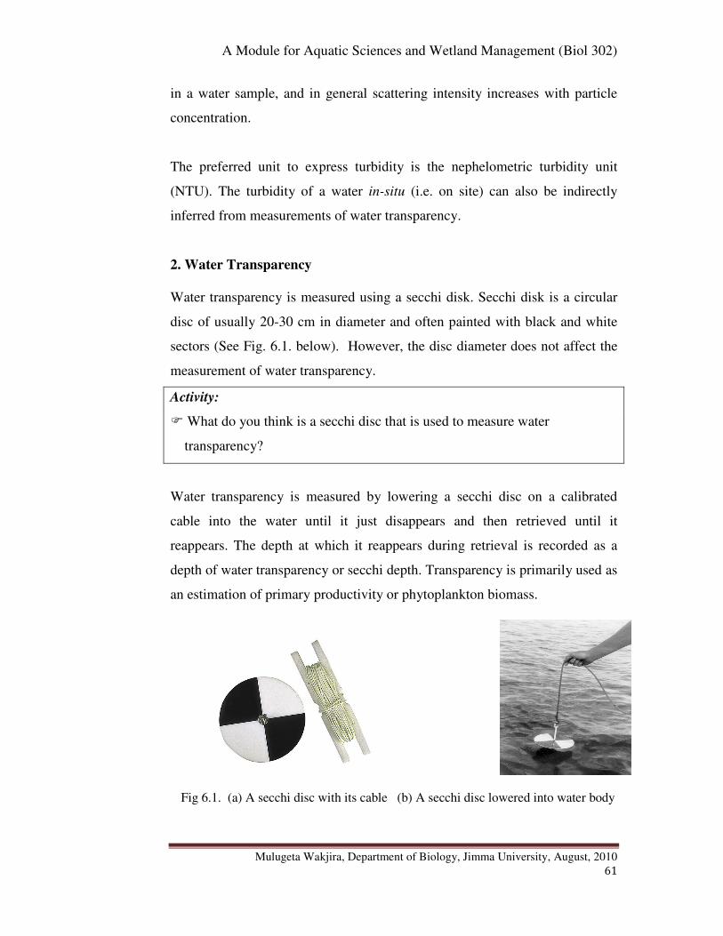
A Module for Aquatic Sciences and Wetland Management (Biol 302)
Mulugeta Wakjira, Department of Biology, Jimma University, August, 2010
61
in a water sample, and in general scattering intensity increases with particle
concentration.
The preferred unit to express turbidity is the nephelometric turbidity unit
(NTU). The turbidity of a water in-situ (i.e. on site) can also be indirectly
inferred from measurements of water transparency.
2. Water Transparency
Water transparency is measured using a secchi disk. Secchi disk is a circular
disc of usually 20-30 cm in diameter and often painted with black and white
sectors (See Fig. 6.1. below). However, the disc diameter does not affect the
measurement of water transparency.
Activity:
� What do you think is a secchi disc that is used to measure water
transparency?
Water transparency is measured by lowering a secchi disc on a calibrated
cable into the water until it just disappears and then retrieved until it
reappears. The depth at which it reappears during retrieval is recorded as a
depth of water transparency or secchi depth. Transparency is primarily used as
an estimation of primary productivity or phytoplankton biomass.
Fig 6.1. (a) A secchi disc with its cable (b) A secchi disc lowered into water body
A Module for Aquatic Sciences and Wetland Management (Biol 302)
Mulugeta Wakjira, Department of Biology, Jimma University, August, 2010
62
3. Temperature
Temperature is an important parameter in natural surface water systems.
Temperature of surface waters governs to a large extent the biological species
present and their rates of activity. Temperature has an effect on most chemical
reactions that occur in natural water systems. Temperature also has a
pronounced effect on the solubility of gasses in water. An increases water
temperature favours the conversion of ammonium ion (NH4+) in to ammonium
(NH3) which is toxic to the aquatic life including fish. Temperature is often
measured by a digital temperature meter.
4. pH
pH is the way of expressing the hydrogen ion activity as a measure of acidity
of the water. At a given temperature the intensity of the acidic character of a
solution is indicated by pH as: pH = - log [H+]. PH scale is usually represented
as ranging from 0 to 14, with pH 7 at 25oc representing absolute neutrality,
less than 7 represents acidity and greater 7 represents basicity.
Activity:
� Why do you think that pH measurement is important in the study of water
quality?
pH of the aquatic habitats could vary on a daily basis. During the day time
(when concentration of CO2 is relatively less due to more photosynthesis) pH
may rise and during night time (when CO2 concentration is relatively high due
to less photosynthesis) it may fall beyond the optimal level and that, in turn,
can increase the concentration of the toxic ammonia (NH3). Water pH is
measured on site using digital pH meters.
A Module for Aquatic Sciences and Wetland Management (Biol 302)
Mulugeta Wakjira, Department of Biology, Jimma University, August, 2010
63
Activity:
� Among the physico-chemical parameters of water quality we have seen so
far, which ones affect the concentration of toxic ammonia? Explain.
5. Conductivity
Conductivity is a measure of the ability of the aqueous solution to conduct an
electric current.
Activity:
Q. What components of water are responsible for water to conduct an electric
current? Thus, conductivity indirectly measures what?
Water conductivity depends on the presence of ions or salts, their
concentration and mobility, and temperature. It is measured using
conductivity meter on site and expressed as µmhos/cm or µS/cm.
Conductivity is measured as an estimate of dissolved charged atoms or
molecules. It is thus used to estimate the total dissolved solids TDS (in mg/L)
by multiplying it by a certain conversion factor. Pure water often has less
conductivity than polluted water.
6. Nitrogen
Nitrogen is an essential nutrient for algal growth. Nitrogen in water bodies can
be measured in the form of nitrogen containing compounds such as ammonia
(NH3), nitrate (NO3-) and nitrite (NO2
-) following standard laboratory
procedures. It is expressed as µg/L or mg/L. In the presence of oxygen,
ammonia can be converted by microorganisms known as nitrosomonas to
nitrite, which in turn is oxidized by nitrobacter to nitrates as shown below.
.
NH3 +O2 Nitrosomonas NO2- + 3H
+ Nitrobacter (+ O2 ) 2NO3
-
A Module for Aquatic Sciences and Wetland Management (Biol 302)
Mulugeta Wakjira, Department of Biology, Jimma University, August, 2010
64
Activity:
1. The biological process of conversion of ammonia (NH3) into nitrite
(NO2-) and then into nitrate (NO3
-) by bacteria is known as what?
3. What do you think are the sources of nitrogen in the water bodies?
7. Phosphate
Phosphorus, together with nitrogen is an essential nutrient for algal growth,
and when in excess it is one of the leading causes of eutrophication. The
primary sources of phosphorus in natural systems include wastewater
treatment facilities, runoff of fertilizer from agricultural operations, detergents
and some natural sources. It is expressed as µg/L or mg/L.
Activity:
� In what forms of compounds do you think that phosphorus can be found in
natural waters?
Orthophosphates and polyphosphates are the most common forms of
inorganic phosphorus found in natural waters. Orthophosphates contain a
single phosphorus molecule, and common orthophosphates include trisodium
phosphate (Na3PO4), disodium phosphate (Na2HPO4), monosodium phosphate
(NaH2PO4), and diammonium phosphate ((NH4)2HPO4). Polyphosphates
contain multiple phosphorus molecules, and examples include sodium
hexametaphosphate (Na3 (PO3)6), sodium tripolyphosphate (Na5P3O10), and
tetrasodium pyrophosphate (Na4P2O7). These are measured using standard
laboratory procedures to give a measure of phosphorus in water.
8. Dissolved Oxygen (DO)
Natural levels of dissolved oxygen in surface waters range from 7 mg/L to 14
mg/L, depending on temperature, salt concentration, and the amount of
biodegradable organic matter.
A Module for Aquatic Sciences and Wetland Management (Biol 302)
Mulugeta Wakjira, Department of Biology, Jimma University, August, 2010
65
Activity:
� On a small piece of paper, please try to write down how factors such as
water temperature, salt concentration and the amount of biodegradable
organic matter affect the amount of dissolved oxygen in the water.
When organic pollution is present, for example, due to a combined sewer
overflow, microorganisms in the water utilize the available oxygen to convert
the organic material to cell mass and carbon dioxide. As a result, the
dissolved oxygen concentration can drop to levels significantly below 7 mg/L.
Dissolved oxygen in the natural waters can be measured directly on site using
appropriate digital oxygen meter or in the lab using titration methods such as
Winkler method.
9. Biochemical oxygen demand (BOD)
This is measure the amount of organic pollution in terms of the amount of
oxygen required by microorganisms to biologically degrade organic wastes.
Complete stabilization of a waste by microorganisms requires too long
incubation period; therefore, the 5-day period has been accepted as a standard.
The 5-day BOD (known as BOD5) is the total amount of oxygen consumed by
microorganisms during the first 5 days of biodegradation. Samples are
incubated at 20oC in darkness to prevent algae from adding oxygen to the air
tight bottle. The BOD of the water is given by an expression:
� BOD = DOt0 - DOt5 where DOt0 is the amount of dissolved oxygen (mg/L)
of the water at time t = 0 and DOt5 is the amount of dissolved oxygen
(mg/L) of the water after 5 days. The amount of dissolved oxygen during
the initial (DOt0) and dissolved oxygen after 5-days incubation (DOt5) are
measured following standard laboratory procedures.
A Module for Aquatic Sciences and Wetland Management (Biol 302)
Mulugeta Wakjira, Department of Biology, Jimma University, August, 2010
66
10. Chemical oxygen demand (COD)
The Chemical Oxygen Demand (COD) is the amount of oxygen needed to
chemically oxidize organic wastes in the water under investigation. In the
COD test, a strong chemical oxidizing agent is used to oxidize the organics.
The primary advantage of COD over BOD is that it is relatively fast, taking 2
to 3 hours, whereas BOD requires 5 days to complete. Another difference in
the test methods is that BOD is a biochemical process as measured by the
ability of microbes to degrade the organics, whereas COD is purely a
chemical process.
5.2.2. Biological Parameters
Aquatic organisms have preferred habitat requirements with respect to the
physical, chemical and biological conditions. Variations in one or more of
these conditions can result in reduction in species numbers or a change in
species dominance or total loss of sensitive species by death or migration.
This can be employed to measure water quality of aquatic habitats in one of
the two main approaches: methods based on ‘indicator’ organisms and
methods based on community structure.
An indicator organism is a species selected for its tolerance or more frequently
for its susceptibility to various types of pollutions or its effects. The various
groups of organisms used as indicators of water quality include bacteria,
algae, macroinvertebrates, protozoa, macrophytes and fish. However, the use
of each group of organisms has advantages and limitations. In streams, rivers,
and lakes, the diversity of fish and insect species provides a good measure of
water quality.
Various biotic scores or biotic indices (biotic indexes) are used in order to
determine whether the measurement of a certain group of organisms indicate
pollution or in order to determine the water quality of the sampled water body.
A Module for Aquatic Sciences and Wetland Management (Biol 302)
Mulugeta Wakjira, Department of Biology, Jimma University, August, 2010
67
In this course, however, only three biological measurements namely
bacteriological, algal (chlorophyll a) and benthic macroinvertebrates will be
presented and discussed with their specific biotic scores or indices.
1. Bacteriological Analysis
This is a microbiological analytical procedure of analyzing water to identify
the type or estimate the number of bacteria present in the water sample in the
study of water quality. Bacteriological analysis of water can have two targets:
analysis for the indicator organisms or analysis for the pathogens that might
cause concern. Indicator bacteria include non-specific coliforms such as
Escherichia coli and Pseudomonas aeruginosa that are very commonly found
in the human or animal gut and which, if detected, may suggest the presence
of sewage.
Activity:
� Though the bacteriological analysis of water aims two targets, in most
bacteriological analysis of water the primary analysis is for indicator
bacteria rather than the pathogenic bacteria. Why do you think that this is
so?
Indicator bacteria are used because even when one is infected with more
pathogenic bacteria, more indicator bacteria are excreted than the pathogens.
It is thus logical to deduce that if indicator bacteria levels are low, then
pathogen levels will be very much lower or absent, and conversely.
Activity:
� In the above paragraph it has been mentioned that analysis for the
indicator bacteria is more preferable than for the pathogens. Do you think
that there is a situation when we have to go for pathogen analysis?
Explain.
A Module for Aquatic Sciences and Wetland Management (Biol 302)
Mulugeta Wakjira, Department of Biology, Jimma University, August, 2010
68
When indicator organisms levels exceed specific sets, analysis for pathogens
may be undertaken using specific culture methods or molecular biology.
Bacteriological analysis of water is usually performed using culture,
biochemical and sometimes optical methods. Some of the various methods
that can be applied in the bacteriological water quality analysis include plate
count, multiple tube method, ATP testing, membrane filtration and pour
plates. In plate count method bacteria grow in colony on a nutrient medium so
that the colony becomes visible to the naked eye and the number of colonies
on a plate can be counted.
Activity:
� What is a culture medium for bacteria? How many different types of
bacterial culture media do you know?
A culture medium is a substance containing nutrients in which bacteria or
other microorganisms or tissues are cultivated for scientific purposes. Typical
media used in bacteriological water quality analysis include Plate count agar
for a general count or MacConkey agar to count gram-negative bacteria such
as Escherichia coli (E.coli).
Activity:
� In bacteriological water quality analysis, if you discover a large number of
coilform bacteria such as E. coli, what kind of pollutant do you expect to
have polluted the water? Explain why.
2. Chlorophyll a Analysis
Chlorophyll a is the most abundant and important pigment which generally
constitutes 2 to 5% of the dry weight of an algal cell. Thus chlorophyll a is
often measured to give an approximate indication of total phytoplankton
biomass thus the trophic (productivity) status of the water body that could be
A Module for Aquatic Sciences and Wetland Management (Biol 302)
Mulugeta Wakjira, Department of Biology, Jimma University, August, 2010
69
caused due to nutrient enrichment such as nitrates and phosphates. The higher
the chlorophyll concentration is the higher the abundance of the
phytoplankton, and conversely.
Activity:
1. In section 1.1.1. of this module, we have discussed about the productivity
of the lentic (still) water bodies. What is a Eutrophic lake?
2. Which types of pollutants (discussed in chapter 5 of this module)
accelerate the eutrophication of lakes?
3. What are the effects of excessive increase in lake primary productivity or
hypereutrophication?
Chlorophyll a samples are collected and transported to laboratory in black or
translucent bags. It is processed immediately up on arrival in the laboratory
following standard procedures (e.g. Clesceri et al., 1998).
Activity:
� Why should the chlorophyll samples be kept in dark or translucent bags
during transportation from field back to the laboratory?
At the end of laboratory procedures, the amount of chlorophyll a is measured
using various methods. However, a method known as spectrophotometery is
much commonly used. In this method the amount of light absorbance by
chlorophyll a solution is measured using an instrument known as
spectrophotometer. Finally the absorbance values are converted into the
chlorophyll a concentrations using standard formula:
Chlorophyll a = (26.73 (663a-665b)V2)/(V1) (L) mgm-3
Where,
V1 = Volume of sample (m3)
V2 = Volume of extract (L)
L = Light path length of cuvette (cm)
A Module for Aquatic Sciences and Wetland Management (Biol 302)
Mulugeta Wakjira, Department of Biology, Jimma University, August, 2010
70
The value 26.7 = the absorbance correction. (Source: Bartram and Balance,
1996)
Activity:
� Dear student, you have now understood the purpose and the processes of
sampling and measuring chlorophyll a. Finally after you calculate the
chlorophyll a concentrations using the above formula, how will you make use
of it to estimate the trophic status of the water body from which the
chlorophyll a is sampled?
The trophic status of a water body is estimated from chlorophyll a
concentrations in reference to standard trophic classification schemes (See
Appendix 3)
3. Benthic Macroinvertebrates
Benthic macroinvertebrates are various groups of invertebrates including
flatworms (e.g. planaria), mollusks (e.g. snail) and mainly insects (e.g.
caddisflies, dragonflies, etc) that inhabit the floor of the aquatic habitats.
These organisms have differing tolerance to water pollution impacts. Some
are easily susceptible or sensitive to water pollution, some are partly sensitive
and others are tolerant of water pollution impacts (See Appendix 1).
Activity:
� Three categories of macroinvertebrates are listed in appendix 1 according
to their water sensitivity to water pollution. If you are given a task to
assess water quality of a given lake or river using macroinvertebrates as
parameter, which of the three categories of the macroinvertebrates are you
going to look for? Why?

A Module for Aquatic Sciences and Wetland Management (Biol 302)
Mulugeta Wakjira, Department of Biology, Jimma University, August, 2010
71
In assessing any impact of pollution in a given water body using
macroinvertebrates one has to collect the organisms following standard field
procedures. A kick net or dip net is often used to collect the
macroinvertebrates. After collection the macroinvertebrates are sorted usually
in the field and then transported to laboratory preserved in 70 % alcohol for
identification (using identification keys e.g. Bouchard, 2004) and
enumeration.
Activity:
� In the above paragraph we have mentioned that the macroinvertebrates are
identified and enumerated after collection. Then how are you going to use
the data to interpret into the status of water quality from which they are
collected? Think carefully about this before you pass on to read the
following paragraphs.
Different biological indexes and scores of macroinvertebrates are used to
interpret the macroinvertebrate data into water quality. Two biological indices
namely EPT index and the Chandler biotic index and one scoring system
known as the Biological monitoring working party (BMWP) score are
attached in Appendix 2.
Activity:
� By referring to the biological indices and the score of macroinvertebrates
in Appendix 2 briefly describe how they are similar and different.
5.2.3. Sampling of Surface Waters
5.2.3.1. Designing Sampling Programs
In designing water quality sampling programs various factors should be taken
in to account. Fir instance, factors such as sampling techniques, the timing and
A Module for Aquatic Sciences and Wetland Management (Biol 302)
Mulugeta Wakjira, Department of Biology, Jimma University, August, 2010
72
frequency of timing, procedures related to sample collection, transport and
analysis should be considered.
Ecological methods of water quality assessments can use a wide range of
sampling techniques. These include:
� Qualitative technique-e.g. selection of macrophytes by hand
� Semi-quantitative technique-e.g. selection of benthic organisms using
a standardized hand net technique
� Fully quantitative technique-e.g. using bottle samples for plankton or
grab samples for benthic organisms.
Activity:
� In water quality sampling, do you think that sampling should be made for
an extended period of time? Why?
Sampling of parameters, such as macroinvertebrates, is preferable during dry
season in tropical climate such as Ethiopia as this timing gives representative
samples of the organisms. Most of the time in the study of water quality, the
primary goal is to assess the influence of human actions, not the effect of
natural variation through time, on aquatic habitats. Thus samples should be
collected during a relatively short period.
Moreover, sample collectors should take into account and apply all the
procedures associated with the collection and transport of samples to prevent
the deterioration of the samples. In general, a well planned water quality
sampling program should have checklist of various items to make sure that no
equipment or chemical required for sampling is missing. The water sampling
field work checklist should include the following important elements among
others:
� Sampling materials
� Documentation materials
A Module for Aquatic Sciences and Wetland Management (Biol 302)
Mulugeta Wakjira, Department of Biology, Jimma University, August, 2010
73
� On-site test materials
� Safety materials
� Transport materials
� Calibration of meters and other equipment
Activity:
���� For the basic elements of water quality sampling checklist listed above
try to list down some examples of materials that need to be included.
5.2.3.2. Safety in the Field
During water sampling personnel (i.e. people working the sampling) may
encounter a wide range of hazards. For example:
� Access to the sampling stations may involve dangerous landscape
� The water to be sampled may be highly contaminated with various
pollutants
� The possibility of slipping and injury while wading in streams to take
water samples, etc.
Activity:
� Dear student, now we have seen about the hazards that await us while we
go out for field work to take water samples for water quality assessment.
So, before you proceed to the next part, please take a moment and try to
jot down what safety cares one should take during water sampling.
Thus, while leaving for filed work to take water samples one should have and
obey the following safety practices:
� Consistent use of suitable protective clothing such as rubber gloves to
protect against contaminants.

A Module for Aquatic Sciences and Wetland Management (Biol 302)
Mulugeta Wakjira, Department of Biology, Jimma University, August, 2010
74
� Training on the awareness of potential hazards and how to deal with them
such as on water safety and first-aid.
� Having a first aid kit carried at all times
5.2.3.3. Hydrological Measurements
During water quality sampling hydrological measurements should be taken
since they are essential for the interpretation of water quality data. This is
because variations in hydrological conditions have important effects on water
quality.
Activity:
� Please give some examples of hydrological conditions that should be
recorded during water quality sampling.
Hydrological factors such as discharge (i.e. the volume of water passing
through a cross section of river in a unit time, m3/second), the velocity of
water flow (m/second), turbulence, water depth, rainfall, wind, erosion,
etc are some of the factors that need to be recorded during water sampling.
5.2.3.4. Types of Samples taken from Surface Waters
Two different types of samples can be taken from rivers, lakes and similar
surface waters. These are Grab samples and Composite samples. Grab
samples are the simplest type taken at a selected site, time and depth. These
are also known as “spot” or “snap” samples. Composite samples, also known
as integrated samples, are made of several different parts of samples. The
following are examples of composite samples:
� Depth-integrated sample: combining samples taken at various
depths
� Area-integrated sample: combining samples taken at various sites

A Module for Aquatic Sciences and Wetland Management (Biol 302)
Mulugeta Wakjira, Department of Biology, Jimma University, August, 2010
75
� Time-integrated sample: combining samples taken at different
times
The type of composite sample to be taken is determined by the objective of
sampling. Generally, in water quality sampling programs, standard guidelines
(e.g. Bartram and Balance, 1996) should be followed in collecting samples for
physico-chemical and biological parameters
A Module for Aquatic Sciences and Wetland Management (Biol 302)
Mulugeta Wakjira, Department of Biology, Jimma University, August, 2010
76
� Chapter Review Questions
Answer the following questions properly. Refer to the appropriate sections to
confirm your answers
1. What is water quality?
2. What are the purposes of measuring water quality?
3. What are factors that affect water quality?
4. List down the various physico-chemical parameters used to measure
water quality.
5. Explain how each of the various physico-chemical parameters can be
used to measure water quality.
6. What is Biochemical oxygen demand (BOD)? How does it differ from
the chemical oxygen demand (COD)?
7. What is the difference between water transparency and turbidity? How
do we measure each?
8. Why is pH important in measuring water quality?
9. What are examples of biological parameters we can use to measure
water quality?
10. What does Bacteriological analysis help in water quality
measurement? Give examples.
11. How does chlorophyll a measurement help in assessing water quality?
12. What are the benthic macroinvertebrates? How are they used in water
quality assessment?
13. What are biological indices or scores in water quality assessments?
Give examples.
14. What are the basic elements of a field checklist of well planned water
sampling program should include?
15. What is field safety during water sampling? Give examples
16. What are the various hydrological parameters that should be recorded
or measured in water quality assessment?
A Module for Aquatic Sciences and Wetland Management (Biol 302)
Mulugeta Wakjira, Department of Biology, Jimma University, August, 2010
77
Chapter 6: Aquatic Resources
Chapter Objectives:
At the end of this chapter you will be able to:
� Explain what is meant by fisheries
� Distinguish between finfish and shellfish
� List the major groups of finfish
� Give examples of shellfish
� Tell the taxonomic hierarchy of finfish
� Discuss about the various categories of Ethiopian fish
� List the economically important families of Ethiopian fish
� Explain the reason for the underdevelopment of Ethiopian capture
fishery and aquaculture
� Discuss about the past aid or assistances given to Ethiopian fishery
� Tell the current status of Ethiopian fishery
6.1 Fish and Fisheries
Dear student, let us now start the topic by defining fishery (fisheries) before
we go on the general description of fish.
Activity:
� Take a moment and try to distinguish between fish and fisheries. Are the
two terms similar or different?
Fishery (fisheries) is a business or an activity of fishing. It comes in two forms
namely capture fishery and aquaculture. Capture fishery is the practice of
catching fish from natural water bodies using various techniques for
commercial or recreational purpose. Aquaculture is, however, the growing or
farming of fish (or other beneficial aquatic organisms) in the natural or
artificial water bodies mainly for food or commercial purpose.
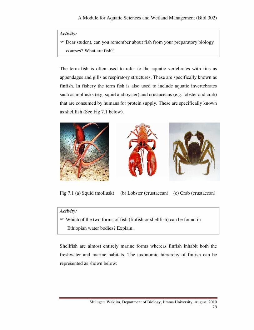
A Module for Aquatic Sciences and Wetland Management (Biol 302)
Mulugeta Wakjira, Department of Biology, Jimma University, August, 2010
78
Activity:
� Dear student, can you remember about fish from your preparatory biology
courses? What are fish?
The term fish is often used to refer to the aquatic vertebrates with fins as
appendages and gills as respiratory structures. These are specifically known as
finfish. In fishery the term fish is also used to include aquatic invertebrates
such as mollusks (e.g. squid and oyster) and crustaceans (e.g. lobster and crab)
that are consumed by humans for protein supply. These are specifically known
as shellfish (See Fig 7.1 below).
Fig 7.1 (a) Squid (mollusk) (b) Lobster (crustacean) (c) Crab (crustacean)
Activity:
� Which of the two forms of fish (finfish or shellfish) can be found in
Ethiopian water bodies? Explain.
Shellfish are almost entirely marine forms whereas finfish inhabit both the
freshwater and marine habitats. The taxonomic hierarchy of finfish can be
represented as shown below:
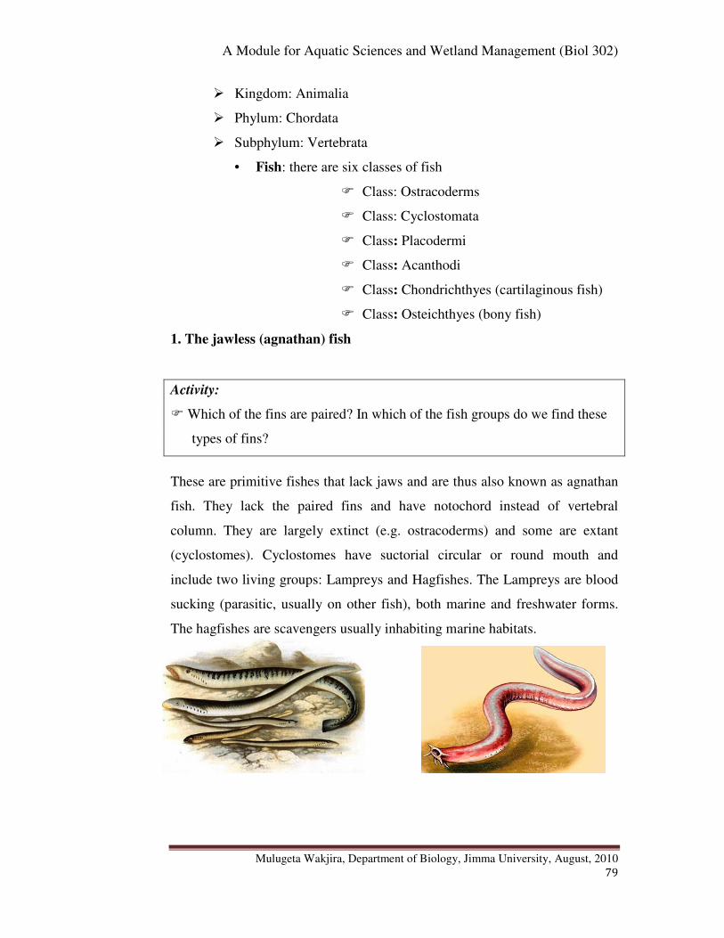
A Module for Aquatic Sciences and Wetland Management (Biol 302)
Mulugeta Wakjira, Department of Biology, Jimma University, August, 2010
79
� Kingdom: Animalia
� Phylum: Chordata
� Subphylum: Vertebrata
• Fish: there are six classes of fish
� Class: Ostracoderms
� Class: Cyclostomata
� Class: Placodermi
� Class: Acanthodi
� Class: Chondrichthyes (cartilaginous fish)
� Class: Osteichthyes (bony fish)
1. The jawless (agnathan) fish
Activity:
� Which of the fins are paired? In which of the fish groups do we find these
types of fins?
These are primitive fishes that lack jaws and are thus also known as agnathan
fish. They lack the paired fins and have notochord instead of vertebral
column. They are largely extinct (e.g. ostracoderms) and some are extant
(cyclostomes). Cyclostomes have suctorial circular or round mouth and
include two living groups: Lampreys and Hagfishes. The Lampreys are blood
sucking (parasitic, usually on other fish), both marine and freshwater forms.
The hagfishes are scavengers usually inhabiting marine habitats.
A Module for Aquatic Sciences and Wetland Management (Biol 302)
Mulugeta Wakjira, Department of Biology, Jimma University, August, 2010
80
Fig 7.2 (a) Sea lampreys (Pteromyzon marinus) (b) Atlantic hagfish (Myxine
glutinosa)
2. The Jawed (gnathostomatan) Fish
This includes the rest of the four fish classes (Placodermi, Acanthodi,
Chondrichthyes and Osteichthyes). Placodermi and Acanthodi are extinct
whereas chondrichthyes and osteichthyes are extant groups. These are fish
with jaws and are thus also known as gnathostomatan fish. In contrast to the
agnathan fish, these possess paired fins. Fishes of the extinct class Placodermi
were the first vertebrates to develop jaws and paired fins. A branch of
Placodermi probably gave rise to the two main modern classes of fish: the
cartilaginous and bony fish.
2.1. The Cartilaginous Fish
The cartilaginous fishes include two major subgroups namely the
elasmobranches (such as sharks, rays, skates) and the holocephalans (such as
chimaeras or ratfish). The cartilaginous fish are distinguished from the bony
fish by their cartilage endoskeleton, lack of swim bladders, lack of a gill
covering (operculum) and possession of teeth-like placoid scales. The
cartilaginous fish have a rough or a sand paper quality as a result of their
teeth-like placoid scales. They are almost exclusively marine in distribution.
2.2. The Bony Fish
Activity:
� Dear student, so far we have seen two major categories of finfish: the
agnathan fish and the cartilaginous fish. Now, before you pass on to read
the following sections take out a piece of paper and try o write down how
the bony fishes can be distinguished from these two forms of fish.
Bony fishes are distinguished from other living fishes by their possession of
bony skeletons and a swim bladder which functions as a float or, in a few
fishes, as a lung. They also possess a bony gill cover known as operculum.
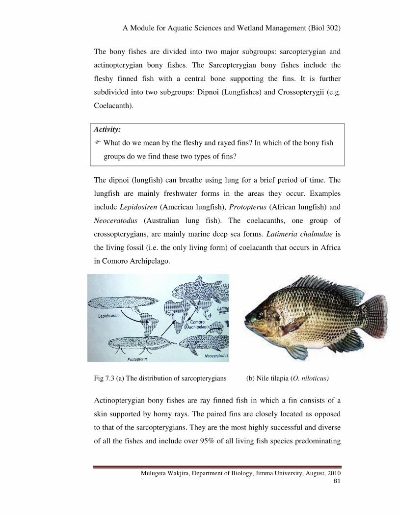
A Module for Aquatic Sciences and Wetland Management (Biol 302)
Mulugeta Wakjira, Department of Biology, Jimma University, August, 2010
81
The bony fishes are divided into two major subgroups: sarcopterygian and
actinopterygian bony fishes. The Sarcopterygian bony fishes include the
fleshy finned fish with a central bone supporting the fins. It is further
subdivided into two subgroups: Dipnoi (Lungfishes) and Crossopterygii (e.g.
Coelacanth).
Activity:
� What do we mean by the fleshy and rayed fins? In which of the bony fish
groups do we find these two types of fins?
The dipnoi (lungfish) can breathe using lung for a brief period of time. The
lungfish are mainly freshwater forms in the areas they occur. Examples
include Lepidosiren (American lungfish), Protopterus (African lungfish) and
Neoceratodus (Australian lung fish). The coelacanths, one group of
crossopterygians, are mainly marine deep sea forms. Latimeria chalmulae is
the living fossil (i.e. the only living form) of coelacanth that occurs in Africa
in Comoro Archipelago.
Fig 7.3 (a) The distribution of sarcopterygians (b) Nile tilapia (O. niloticus)
Actinopterygian bony fishes are ray finned fish in which a fin consists of a
skin supported by horny rays. The paired fins are closely located as opposed
to that of the sarcopterygians. They are the most highly successful and diverse
of all the fishes and include over 95% of all living fish species predominating
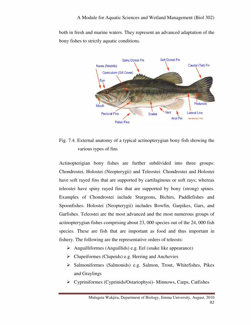
A Module for Aquatic Sciences and Wetland Management (Biol 302)
Mulugeta Wakjira, Department of Biology, Jimma University, August, 2010
82
both in fresh and marine waters. They represent an advanced adaptation of the
bony fishes to strictly aquatic conditions.
Fig. 7.4. External anatomy of a typical actinopterygian bony fish showing the
various types of fins
Actinopterigian bony fishes are further subdivided into three groups:
Chondrostei, Holostei (Neopterygii) and Teleostei. Chondrostei and Holostei
have soft rayed fins that are supported by cartilaginous or soft rays; whereas
teleostei have spiny rayed fins that are supported by bony (strong) spines.
Examples of Chondrostei include Sturgeons, Bichirs, Paddlefishes and
Spoonfishes. Holostei (Neopterygii) includes Bowfin, Garpikes, Gars, and
Garfishes. Teleostei are the most advanced and the most numerous groups of
actinopterygian fishes comprising about 23, 000 species out of the 24, 000 fish
species. These are fish that are important as food and thus important in
fishery. The following are the representative orders of teleosts:
� Anguilliformes (Anguillids) e.g. Eel (snake like appearance)
� Clupeiformes (Clupeids) e.g. Herring and Anchovies
� Salmoniformes (Salmonids) e.g. Salmon, Trout, Whitefishes, Pikes
and Graylings
� Cypriniformes (Cyprinids/Ostariophysi)- Minnows, Carps, Catfishes

A Module for Aquatic Sciences and Wetland Management (Biol 302)
Mulugeta Wakjira, Department of Biology, Jimma University, August, 2010
83
� Perciformes e.g. Perches, Wrasses, Dolphins, Hake, Mackerel, Tuna
6.2. The Ethiopian Fish and Fisheries
6.2.1. The Classification of Ethiopian Fish
Some of the fishes found in Ethiopian lakes and rivers are given by
Appendix-4. The Ethiopian fish fauna are the bony fishes and freshwater
forms, the majority of them belonging to teleosts. The Ethiopian fish fauna
consists of 153 indigenous and 10 exotic species. It is important to bear in
mind, however, that the diversity and abundance of Ethiopian fish fauna is not
complete and further works are still underway.
Activity:
� What do we mean by the indigenous and exotic fish? Explain.
The Ethiopian indigenous freshwater fauna is a mixture of three different
forms: Nilo-sudanic forms, East African high land forms and Endemic forms.
The Nilo-Sudanic forms are those fishes related to West African fishes and
include genera such as Alestes, Bagrus, Citharinus, Hydrocynus, Hyperopisus,
Labeo, Mormyrus etc. The similarity is assumed due to past connections of the
Nile to Central and West African river systems. These are the dominant forms
in terms of diversity and are represented by a large number of species found in
the Omo-Gibe, Baro-Akobo, Tekeze and Abay drainage basins but
particularly predominate the Nile basin (Baro-Akobo, Tekeze and Abay).
However, some elements of these forms also occur in the Southern Rift Valley
Lakes (Lakes Abaya and Chamo), and the Shebelle-Ghenale basins. However,
Nilotic fishes are almost entirely absent from the Awash and northern rift
valley lakes
The East African highland forms are those related to fishes of eastern and
southern Africa and include genera such as Labeobarbus, Clarias, Garra,
Oreochromis, and Varicorhinus. These are found in the northern Rift Valley
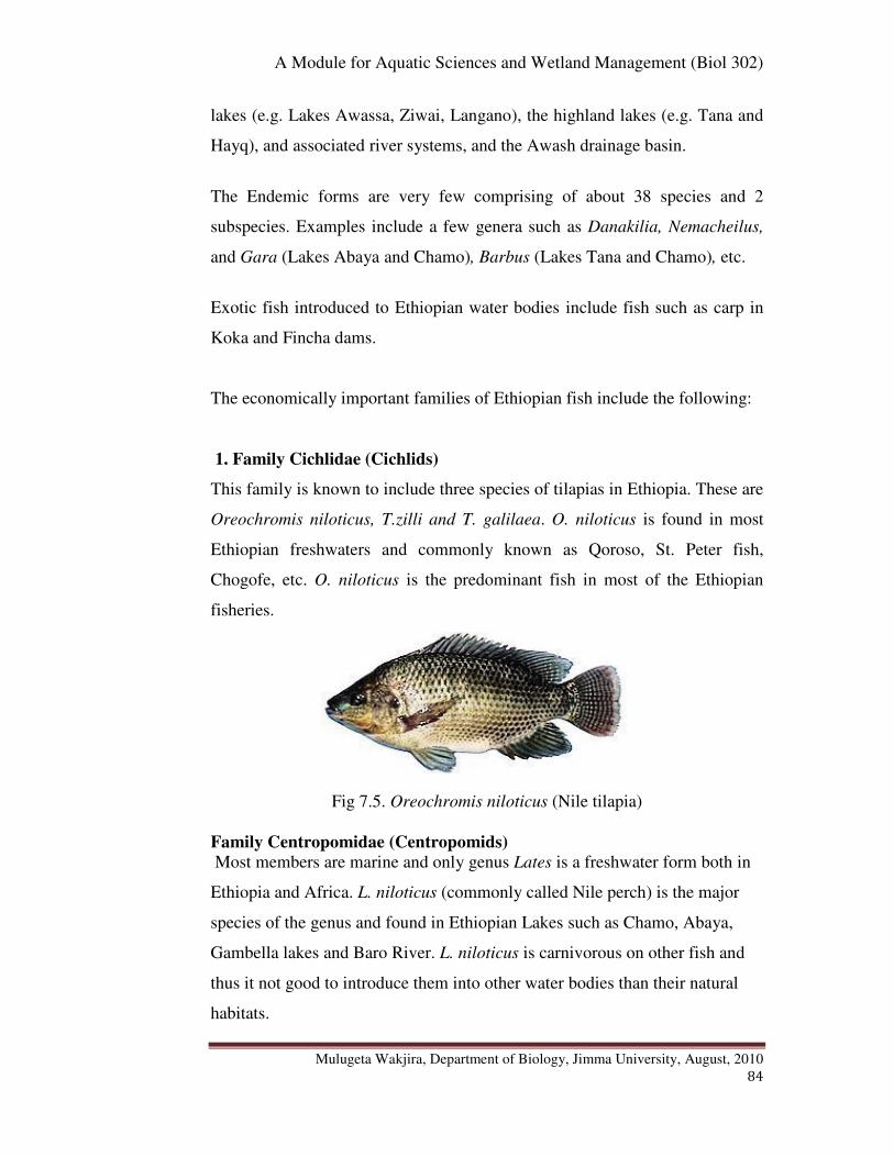
A Module for Aquatic Sciences and Wetland Management (Biol 302)
Mulugeta Wakjira, Department of Biology, Jimma University, August, 2010
84
lakes (e.g. Lakes Awassa, Ziwai, Langano), the highland lakes (e.g. Tana and
Hayq), and associated river systems, and the Awash drainage basin.
The Endemic forms are very few comprising of about 38 species and 2
subspecies. Examples include a few genera such as Danakilia, Nemacheilus,
and Gara (Lakes Abaya and Chamo), Barbus (Lakes Tana and Chamo), etc.
Exotic fish introduced to Ethiopian water bodies include fish such as carp in
Koka and Fincha dams.
The economically important families of Ethiopian fish include the following:
1. Family Cichlidae (Cichlids)
This family is known to include three species of tilapias in Ethiopia. These are
Oreochromis niloticus, T.zilli and T. galilaea. O. niloticus is found in most
Ethiopian freshwaters and commonly known as Qoroso, St. Peter fish,
Chogofe, etc. O. niloticus is the predominant fish in most of the Ethiopian
fisheries.
Fig 7.5. Oreochromis niloticus (Nile tilapia)
Family Centropomidae (Centropomids)
Most members are marine and only genus Lates is a freshwater form both in
Ethiopia and Africa. L. niloticus (commonly called Nile perch) is the major
species of the genus and found in Ethiopian Lakes such as Chamo, Abaya,
Gambella lakes and Baro River. L. niloticus is carnivorous on other fish and
thus it not good to introduce them into other water bodies than their natural
habitats.
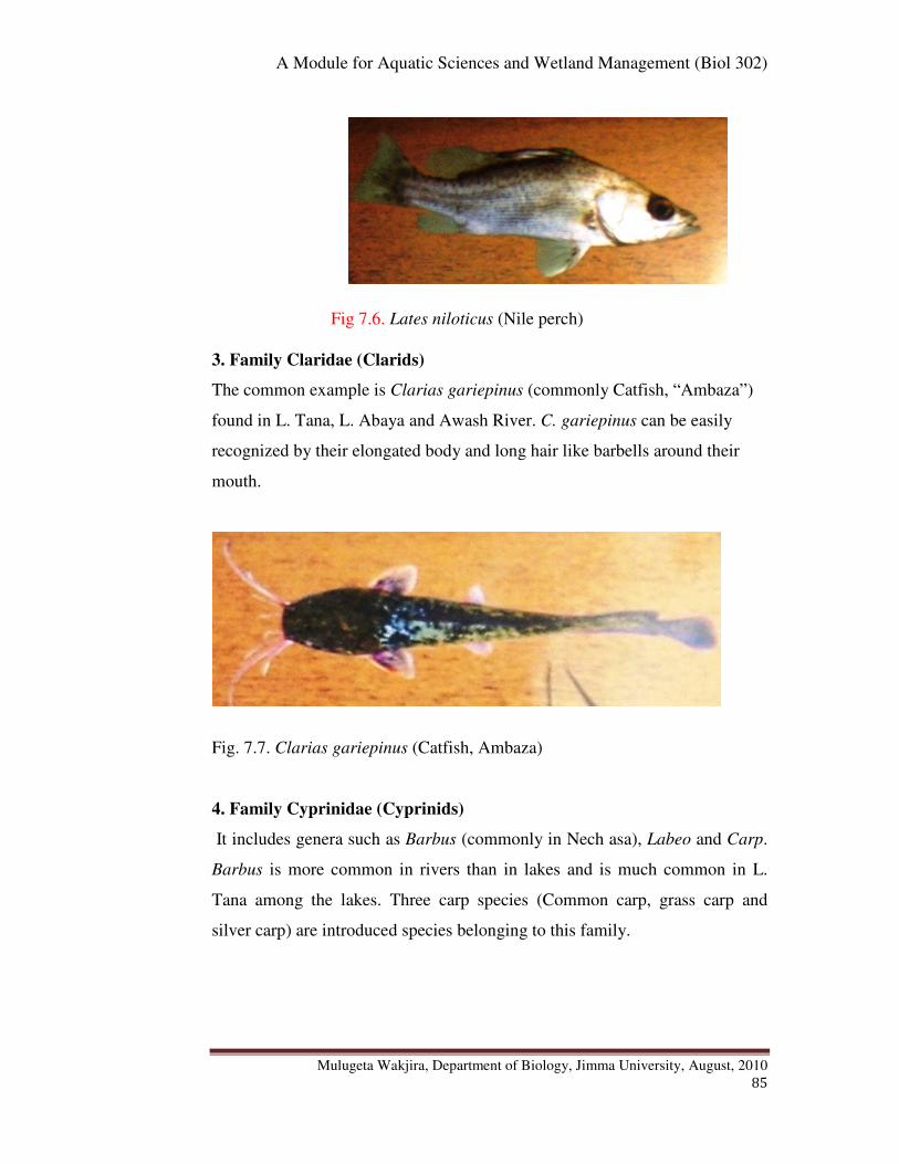
A Module for Aquatic Sciences and Wetland Management (Biol 302)
Mulugeta Wakjira, Department of Biology, Jimma University, August, 2010
85
Fig 7.6. Lates niloticus (Nile perch)
3. Family Claridae (Clarids)
The common example is Clarias gariepinus (commonly Catfish, “Ambaza”)
found in L. Tana, L. Abaya and Awash River. C. gariepinus can be easily
recognized by their elongated body and long hair like barbells around their
mouth.
Fig. 7.7. Clarias gariepinus (Catfish, Ambaza)
4. Family Cyprinidae (Cyprinids)
It includes genera such as Barbus (commonly in Nech asa), Labeo and Carp.
Barbus is more common in rivers than in lakes and is much common in L.
Tana among the lakes. Three carp species (Common carp, grass carp and
silver carp) are introduced species belonging to this family.
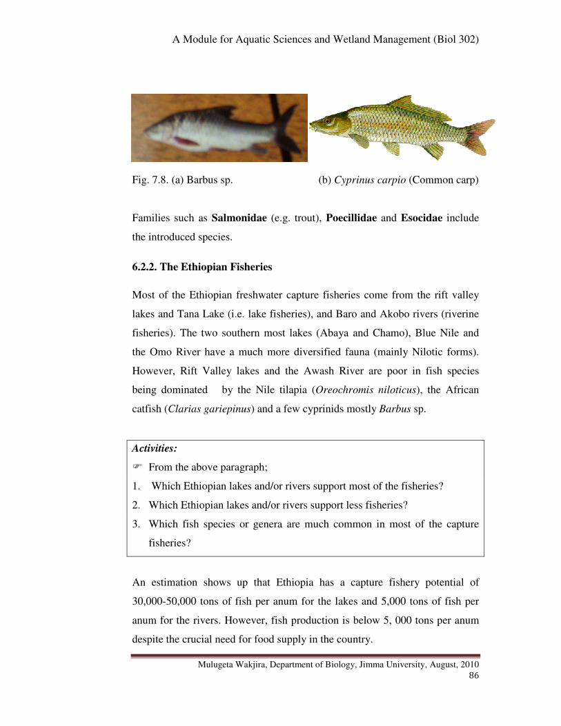
A Module for Aquatic Sciences and Wetland Management (Biol 302)
Mulugeta Wakjira, Department of Biology, Jimma University, August, 2010
86
Fig. 7.8. (a) Barbus sp. (b) Cyprinus carpio (Common carp)
Families such as Salmonidae (e.g. trout), Poecillidae and Esocidae include
the introduced species.
6.2.2. The Ethiopian Fisheries
Most of the Ethiopian freshwater capture fisheries come from the rift valley
lakes and Tana Lake (i.e. lake fisheries), and Baro and Akobo rivers (riverine
fisheries). The two southern most lakes (Abaya and Chamo), Blue Nile and
the Omo River have a much more diversified fauna (mainly Nilotic forms).
However, Rift Valley lakes and the Awash River are poor in fish species
being dominated by the Nile tilapia (Oreochromis niloticus), the African
catfish (Clarias gariepinus) and a few cyprinids mostly Barbus sp.
Activities:
� From the above paragraph;
1. Which Ethiopian lakes and/or rivers support most of the fisheries?
2. Which Ethiopian lakes and/or rivers support less fisheries?
3. Which fish species or genera are much common in most of the capture
fisheries?
An estimation shows up that Ethiopia has a capture fishery potential of
30,000-50,000 tons of fish per anum for the lakes and 5,000 tons of fish per
anum for the rivers. However, fish production is below 5, 000 tons per anum
despite the crucial need for food supply in the country.
A Module for Aquatic Sciences and Wetland Management (Biol 302)
Mulugeta Wakjira, Department of Biology, Jimma University, August, 2010
87
Activity:
� Why do you think that the Ethiopian capture fishery is underdeveloped?
Write down your reasons on a piece of paper before you pass on to read
the following section.
The following are some of the reasons for the under development of the
Ethiopian capture fisheries.
� Lack of tradition in fish consumption or eating leading to less market
demand
� Lack of trained man power - only traditional fishing
� Lack of modern fishing gears and vessels (boats). Only Lake Tana has
got some motorized fishing boats
� Less attention given by the planners, policy makers, etc
� Lack of aid or government fund for the sector
Activity:
� In the past 1980s and 1990s, some aids were given to the development of
Ethiopian capture fishery sector. Can you mention who the donors were?
In 1980s and 1990s the fishery sector has been supported by the European
Union (EU) and the Ethiopian Orthodox Church/Inter Kerk Urk (EOC/DICA)
projects. EU supported the Lake fisheries development project (LFDP) which
was oriented to increase and improve fish production and marketing from the
Rift Valley lakes. LFDP was implemented in two phases: LFDP phase I
between 1981 and 1987 and LFDP phase II between 1992 and 1998.
The Ethiopian Orthodox Church/Inter Kerk Urk (EOC/DICA) implemented a
development project in the southwest bay of Lake Tana from 1986. The
project supported a purchase of motorized fishing boats to the lake for the first
time in the region. The project also extended some small assistance to the
A Module for Aquatic Sciences and Wetland Management (Biol 302)
Mulugeta Wakjira, Department of Biology, Jimma University, August, 2010
88
development of the most southern Lake Chamo through the supply of
equipment and materials to the old established fishers' cooperative in Arba
Minch.
Activity:
� What do you think is the current status of the Ethiopian capture fishery?
Improving? Explain.
In 2004 a National Fisheries Development Study Project was prepared, with
the main objective of acquiring knowledge on the fisheries resource base, and
identifying development and management interventions. The project is,
however, pending subject to secure donor assistance. Thus after the
termination of LFDP II in 1998 the fishery sector has been without actual
project support, and hence its activities have been weakened, and even past
project activities are not sustained.
Activity:
� Do you think that there is any market outlet system for the Ethiopian
fishermen? Explain.
The production increases are being marketed through private channels, with
the FPME (Fish production and Marketing Enterprise, now an Enterprise)
maintaining its level of business.
Activity:
� Dear student, let us now proceed to another form of fishery in Ethiopia:
Aquaculture. How do you compare the status of development of
aquaculture to capture fishery? Better/Less/Same? Why?
A Module for Aquatic Sciences and Wetland Management (Biol 302)
Mulugeta Wakjira, Department of Biology, Jimma University, August, 2010
89
Studies indicate that environmental conditions are conducive for aquaculture
development in Ethiopia. There are also some aquaculture practices in
reservoirs (dams) such as Koka, Fincha, etc. Aquaculture is also
underdeveloped in the country.
Activity:
� Dear student, please discuss with your colleague or another student taking
this course why aquaculture development is also underdeveloped in
Ethiopia.
A Module for Aquatic Sciences and Wetland Management (Biol 302)
Mulugeta Wakjira, Department of Biology, Jimma University, August, 2010
90
� Chapter Review Questions
Answer the following questions properly. Refer to the appropriate sections to
confirm your answers
1. Define fisheries.
2. What is the difference between finfish and shell fish? Give examples.
3. List down the major groups of finfish
4. What are agnathan fish? Give examples
5. What are gnathostomatan fish? Give examples.
6. Which aquatic habitats do agnathan fish, cartilaginous fish and bony
fish occupy?
7. What are the differences between sarcopterygian and actinopterygian
bony fishes?
8. What are the differences between the dipnoi and crossopterygian bony
fishes?
9. What are the differences among chondrostei, holostei and teleostei
bony fishes?
10. List down the major bony fish families important in Ethiopian in
fisheries. Give species or genus level examples.
11. Mention the previous development efforts made in Ethiopian fisheries?
Who were donating fund?
12. What is the current status of Ethiopian fisheries development in
Ethiopia? Explain.
13. What is aquaculture? What is the status of aquaculture development in
Ethiopia?

A Module for Aquatic Sciences and Wetland Management (Biol 302)
Mulugeta Wakjira, Department of Biology, Jimma University, August, 2010
91
Chapter 7. Water Basin Management and Monitoring
Chapter Objectives:
At the end of this chapter you will be able to:
� Define and describe an integrated water resources management
program
� Explain about the various Nile River Treaties and Agreements
� Comment on the Treaties and Agreements from the view points of
better management approach for the river basin
� Tell the goals of Water Directive Framework
� Explain about Ramsar Convention on wetlands
7.1. Basic Water Management and Monitoring Programs
Dear student, let us now see about the various uses of water to human being
and to the natural ecosystems before we can discuss about water management.
Activity:
� Dear student, can you please write down the various uses of water to us
and the nature?
Human beings require water for many different uses including agriculture,
irrigation, hydropower generation, drinking water supply, navigation,
recreation and above all for healthy ecosystems. All these multiple-uses on
water demand coordinated action and management to ensure sustainability of
the water resource. Water is often considered as finite and economic
commodity taking into account of affordability and equity criteria. Particularly
fresh water is a finite and vulnerable resource, but essential to sustain life,
development and the environment.

A Module for Aquatic Sciences and Wetland Management (Biol 302)
Mulugeta Wakjira, Department of Biology, Jimma University, August, 2010
92
Activity:
� Dear student, taking into account of the multiple-use on the water, how do
you think that the water resource can be properly managed to ensure
sustainability?
Water management and development should be based on a participatory
approach, involving users, planners, policy makers and all other stakeholders
and users at all levels. Such management approach is known as Integrated
Water Resources Management (IWRM).
IWRM is a comprehensive, participatory planning and implementation tool
which promotes the coordination for managing and developing water
resources in a way that:
� Balances social and economic needs, and
� Ensures the protection and sustainability of ecosystems for future
generations.
Specifically speaking, IWRM approaches involve applying knowledge from
various disciplines as well as the insights from diverse stakeholders to devise
and implement efficient, equitable and sustainable solutions to water and
development problems. This approach is very important especially in the
management of transboundary water resources.
7.2. The Nile Basin Initiative (NBI)
The Nile River is the longest river in the world and it has been providing life
to the vast Nile basin for hundreds of thousands of years. Two of its major
tributaries are the White Nile and the Blue Nile (Abay) Rivers. The major
source of White Nile is Lake Victoria in east central Africa and the source of
the Blue Nile is Lake Tana in Ethiopian high lands. The White Nile flows
generally north through Uganda and into Sudan where it confluences with the
Blue Nile (Abay) at Khartoum to form the Nile River proper. The Nile River

A Module for Aquatic Sciences and Wetland Management (Biol 302)
Mulugeta Wakjira, Department of Biology, Jimma University, August, 2010
93
continues to flow northwards into Egypt and ultimately into the Mediterranean
Sea. The Nile River basin has an area of more than 3,349,000 km2. Refer to
Appendix-5 on a map of the Nile basin.
Activity:
� From a map of Nile Basin in Appendix-5, is the Nile River a country
bound river or a transboundary river? What do we mean by
Transboundary River?
The Nile River is a transboundary river that generally involves ten African
countries.
Activity:
� Dear student, above we have mentioned that Nile River is a transboundary
river that involves ten African countries. Again by referring to Appendix-
5, can you name those ten Nile basin countries?
Nile basin countries also known as the riparian countries are countries that
lie in the catchment of the Nile River. These include Ethiopia, Sudan, Egypt,
Kenya, Tanzania, Uganda, Rwanda, DR Congo, Burundi and Eritrea. Some of
the countries have only a small part of their area within the basin, whilst
others are virtually entirely within the Basin. Moreover, the countries
contribute differently to the basin and have different needs for the water and
other resources of the basin. The Nile basin within Ethiopia territory
contributes about 58 % to the water of the Nile River.
A Module for Aquatic Sciences and Wetland Management (Biol 302)
Mulugeta Wakjira, Department of Biology, Jimma University, August, 2010
94
Activity:
� Dear student, in Transboundary Rivers like the Nile River:
1. Which country do you think should own the river? Why? Explain.
2. How can the river water be properly and fairly utilized?
3. How can the river be properly managed for sustainability? Whose
responsibility should be the management of the river basin? Explain
Dear student, we will now go on to see the Agreements reached or made
regarding the use and management of the Nile River at various points in time.
Activity:
� Dear student, before you go on to read the following sections on the Nile
River Agreements, please discuss on the topic with your friend and try to
write down the Agreements made so far.
The Nile River Agreements include:
� The Nile Water Agreement of 1929 and 1959
� The Nile Basin Initiative Agreement of May 14th
, 2010
Most of the Nile basin countries have their own policy frameworks that
address the use and management of their water resources including the Nile
River. Let us now see some pints on:
� The Nile Water Agreement of 1929 and 1959
� The Nile Basin Initiative, and
� The Nile Basin Initiative Agreement of May 14th
, 2010
1. The Nile Water Agreement of 1929 and 1959
This is a Nile treaty which Britain signed on behalf of its east African colonies
with Sudan and Egypt. Some aspects of the treaty are:
� Any projects that could threaten the volume of water reaching Egypt
are forbidden.

A Module for Aquatic Sciences and Wetland Management (Biol 302)
Mulugeta Wakjira, Department of Biology, Jimma University, August, 2010
95
� The agreement gives Egypt the right to inspect the entire length of the
Nile.
� Egypt has a right to use about 75 % of the water while Sudan has 11 %
and the rest of the countries share 14 %.
� The other riparian countries have to first seek permission from Egypt
and Sudan before planning for any large scale development projects on
the river that would affect the level and flow of the waters.
� Egypt has the right to control, reject and veto any projects from any
other nations and has the right to undertake any desired projects and
developments freely without consents of other riparian countries.
Activity:
� Dear student, how would you feel about the fairness of this treaty in terms
of equitable access to transboundary resources such as the Nile River? Do
you think that the treaty needs reconsideration? Discuss with any other
student taking the same course in your locality before you read the
following sections.
� The upstream riparian countries criticize the treaty saying that it grants
Egypt the lion's share of the Nile waters ignoring the rest upstream
riparian countries which on the other hand are the major contributors to
the Nile River. The treaty is often regarded as a colonial treaty that cannot
be accepted in the era of Freedom.
Activity:
� It is commonplace to see droughts caused by inadequate rainfall are
becoming much prevalent in the countries like Ethiopia, Kenya, Tanzania
and other upstream countries causing malnutrition. What alternative do
you think that these countries have to change the situation?
A Module for Aquatic Sciences and Wetland Management (Biol 302)
Mulugeta Wakjira, Department of Biology, Jimma University, August, 2010
96
2. The Nile Basin Initiative (NBI)
The struggle for fair and equitable utilization of the Nile River continued to be
a stance of most of the riparian countries. Accordingly, the Nile Basin
Initiative was established by the riparian countries in 1999.
Activity:
� Dear student, what do you think is an NBI? Is it an agreement reached
among the riparian states or a legal body established by the riparian states?
NBI is a transitional arrangement established by the Nile Basin States at the
meeting of their Council of Ministers held in Dar-es-Salaam, Tanzania, on 22nd
February, 1999.
Activity:
� Dear student, now you have learnt that NBI is not an agreement. It is
rather a legal body established by the riparian countries. What do you
think is the role of NBI?
NBI:
� Is responsible to foster cooperation and sustainable development of the
Nile River for the benefit of the inhabitants of the riparian countries.
� Seeks to develop the river in a cooperative manner, share substantial
socioeconomic benefits, and promote regional peace and security.
The NBI secretariat is based in Entebbe, Uganda and led by the Council of
Ministers of Water Affairs of the Nile Basin states (Nile Council of Ministers,
or NILE-COM).

A Module for Aquatic Sciences and Wetland Management (Biol 302)
Mulugeta Wakjira, Department of Biology, Jimma University, August, 2010
97
3. The New Nile Basin Framework of 2010
For over a decade, the nine riparian countries and Eritrea as an observer have
been negotiating to draft a new treaty on the usage of the Nile waters. All the
countries agreed on the framework agreement apart from a clause which will
reduce Egypt and Sudan's right to use more than 85 percent of the water.
However, Egypt and Sudan want to maintain the old status quo of them using
the biggest percentage of the water as stipulated in two colonial agreements
they signed with the British in 1929 and 1959.
Ultimately the Nile Basin Initiative Agreement was signed among four Nile
basin countries (Ethiopia, Rwanda, Tanzania, and Uganda) who signed the
Agreement on the “Nile River Basin Cooperative Framework” in Uganda on
14th
May, 2010. Burundi, Democratic Republic of Congo (DR Congo) and
Kenya are expected to join the agreement sooner. The Cooperative
Framework stipulates fair and equitable utilization of the Nile River basin and
will remain open for one year to allow Egypt and Sudan join the rest of the
countries.
Activity:
� Dear student, what do you think are the arguments of the seven riparian
countries against the old treaty on the Nile Basin and their reasons to sign
a new agreement, the Nile Basin Initiative Agreement on the “Nile River
Basin Cooperative Framework” in May, 2010? Write your answers down
before you pass on to reading the following parts.
Some of the reasons for reaching the Nile Basin Initiative Agreement on the
“Nile River Basin Cooperative Framework” in May, 2010 include:
� The old colonial treaty signed among Britain, Egypt and Sudan was not
fair and does not entail equitable utilization of the Nile River Basin.
A Module for Aquatic Sciences and Wetland Management (Biol 302)
Mulugeta Wakjira, Department of Biology, Jimma University, August, 2010
98
� The riparian countries are now independent states and thus have equal
rights as Egypt to use the Nile waters.
� The upstream countries are in dire need of using the water to generate
hydropower and irrigation following persistent drought which has hit
many of the countries leaving millions of their citizens on the verge of
starvation.
According to the framework agreement the Nile Basin Initiative will be
transformed into the Nile Basin Commission which will coordinate the
equitable usage of the water.
Activity:
� Dear student, among the Agreements on the Nile River we have seen
above, which one can ensure equitability, and the protection and
sustainability of ecosystems for future generations in your opinion. Why?
7.3. The Water Framework Directive
The Water Framework Directive is a European Union water legislation
which commits European Union member states to achieve good qualitative
and quantitative status of all water bodies by 2015. The Directive was made
on 23 October 2000 and came into force 22 December 2000. Currently is an
active legislation.
Dear Student, the following are some of the important points you need to note
about the Directive:
� The Directive establishes a framework for the European Community
action in the field of water policy

A Module for Aquatic Sciences and Wetland Management (Biol 302)
Mulugeta Wakjira, Department of Biology, Jimma University, August, 2010
99
� It is a framework in the sense that it prescribes steps to reach the
common goal rather than adopting the more traditional limit value
approach.
� The directive defines 'surface water status' as the general expression of
the status of a body of surface water, determined by the poorer of its
ecological status and its chemical status.
� Thus, to achieve 'good surface water status' both the ecological status
and the chemical status of a surface water body need to be at least
'good'. Ecological status refers to the quality of the structure and
functioning of aquatic ecosystems of the surface waters.
� Water is an important facet of all life and the water framework
directive sets standards which ensure the safe access of this resource.
The Directive aims “River Basin Management”
7.4. Convention on Wetlands Management
Activity:
� Dear student, in section 1.5 (in chapter 1) of this module, can you please
recall some of the various ecological functions and socio-economic vales
of wetlands? Please write them down.
Recall that wetlands are among the most productive ecosystems. Given the
vulnerability of wetlands, their importance for water supply and the growing
pressures to convert them to agriculture uses, there is an urgent need to try to
achieve sustainable use of wetlands.
Dear student, sustainable management of wetlands involves consideration of
three important factors: Environmental, Socio-economic and Policy factors.
This is shown in Fig 7.1 below.
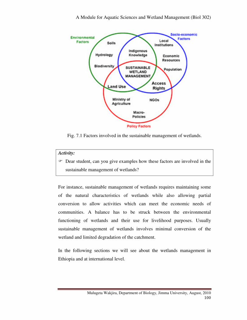
A Module for Aquatic Sciences and Wetland Management (Biol 302)
Mulugeta Wakjira, Department of Biology, Jimma University, August, 2010
100
Fig. 7.1 Factors involved in the sustainable management of wetlands.
Activity:
� Dear student, can you give examples how these factors are involved in the
sustainable management of wetlands?
For instance, sustainable management of wetlands requires maintaining some
of the natural characteristics of wetlands while also allowing partial
conversion to allow activities which can meet the economic needs of
communities. A balance has to be struck between the environmental
functioning of wetlands and their use for livelihood purposes. Usually
sustainable management of wetlands involves minimal conversion of the
wetland and limited degradation of the catchment.
In the following sections we will see about the wetlands management in
Ethiopia and at international level.

A Module for Aquatic Sciences and Wetland Management (Biol 302)
Mulugeta Wakjira, Department of Biology, Jimma University, August, 2010
101
1. Wetlands Management in Ethiopia
Generally in Ethiopia, wetland management has been given little attention
until a non governmental organization namely Ethio Wetlands and Natural
Resources Association (EWNRA) initiated research in southwest Ethiopia,
Illubabor zone, Oromia regional state, for the sustainable management of
wetlands.
2. Wetlands Management at International Level
Ramsar Convention on Wetlands Management is an international
intergovernmental treaty adopted on 2 February 1971 in the Iranian city of
Ramsar to address global concerns regarding wetland loss and degradation. It
is the first of the modern global intergovernmental treaties on the conservation
and sustainable use of natural resources. The Convention entered into force in
1975 and as of December 2006 has 153 Contracting Parties, or member States,
in all parts of the world. Ethiopia is not among the Ramsar Convention
Member State.
The Convention was primarily on wetlands of international importance,
especially as Waterfowl (water birds) habitat. Over the years, however, the
Convention has broadened its scope of implementation to cover all aspects of
wetland conservation and wise use, recognizing wetlands as ecosystems that
are extremely important for biodiversity conservation and for the well-being
of human communities.
The primary purposes of the treaty are to list wetlands of international
importance and to promote their wise use, with the ultimate goal of preserving
the world's wetlands. Methods include restricting access to the majority
portion of wetland areas, as well as educating the public to combat the
misconception that wetlands are wastelands.
A Module for Aquatic Sciences and Wetland Management (Biol 302)
Mulugeta Wakjira, Department of Biology, Jimma University, August, 2010
102
� Chapter Review Questions
Answer the following questions properly. Refer to the appropriate sections to
confirm your answers
1. What is integrated water resource management?
2. Who are stakeholders in integrated water resource management?
3. What are the origins of Nile River? Where does it end?
4. List down the Nile Basin riparian countries.
5. List down the Treaties or Agreements made on the Nile Basin (past
and present).
6. Which Agreement is said to be damaging to the upstream riparian
countries?
7. Which agreement is said to be rational in equitable utilization of
the Nile Basin?
8. Which Agreement is more sound in terms of integrated water
resource management to ensure equitable and sustainable
management of the Nile Basin?
9. What is the Nile Basin Initiative? The Nile Basin Commission?
10. What is the Water directive Framework?
11. What are the three factors that need to be considered in sustainable
management of wetlands?
12. What is the Ethio Wetlands and Natural Resources Association
(EWNRA)?
13. What is Ramsar Convention? Is Ethiopia a member of Ramsar
Convention?

A Module for Aquatic Sciences and Wetland Management (Biol 302)
Mulugeta Wakjira, Department of Biology, Jimma University, August, 2010
103
References
Abebe Getahun (2003). The Nile: Riverine fish and fisheries. Presented at
the Food and water challenge international workshop that took place in
Addis Ababa, Ethiopia on Dec. 10-11, 2003.
Afework Hailu, Wood, A., Abott, P. and Dixon, A. (2000). Sustainable
Wetland Management in Illubabor Zone, South-west Ethiopia:
Understanding wetlands and their management.
Bartram, J. and Ballance, R. (1996). Water Quality Monitoring. A Practical
guide to the design and implementation of water quality studies and
monitoring program., TJ Press (Padstow) Ltd, Britain.
Bouchard, R.W., Jr. (2004). Guide to aquatic macro invertebrates of the
UpperMidwest. Water Resources Center, University of Minnesota, St.
Paul, MN.
Bronmark, C. and Hansson, L. A. (1998). The Biology of lakes and
Ponds. Oxford University Press.
Clesceri, L. S., Greenberg, A. E., Eaton, A. D. (1998). Standard
Methods for the Examination of Water and Wastewater. 20th
ed.
American Public Health Association, USA.
Cowardin, L.M., Carter, V., Golet, F.C. and LaRoe, E.T. (1979).
Classification of wetlands and deepwater habitats of the United States.
U.S. Department of the Interior, Fish and Wildlife service,
Washington, D.C.
Dixon, A. and Wood, A. (2001). Sustainable wetland management for food
security and rural livelihoods in south west Ethiopia: the interactions
of local knowledge and institutions, government policies and
globalization. A paper presented from 5-8 June 2001, National
University of Rwanda.
Ekholm, P., Kallio, K., Salo, S., Pietiläinen, O.P., Rekolainen, S., Laine, Y.
and Joukola, M. (2000). Relationship between catchment
characteristics and nutrient concentrations in an agricultural river
A Module for Aquatic Sciences and Wetland Management (Biol 302)
Mulugeta Wakjira, Department of Biology, Jimma University, August, 2010
104
system. Water Research, 34 (15): 3709-3716.
Environmental Protection Agency (2001). The wetland fact sheets: Types of
Wetlands, USA
James, D. P. and Chanson, H. (1999). A study of extreme reservoir siltation
in Australia. A report on Water 99 Joint Congress - Brisbane, Australia
6-8 July 1999.
Kusler, J. (2006). Common Questions: Wetland Classification. Association of
State Wetland Managers, Inc, New York.
Mesfin Bayou and Getachew Tesfaye (2003). Wetlands: Policy issues in
Ethiopia. Proceedings of Organized by Biological Society of Ethiopia,
Addis Ababa
Mitsch, J. and Gosselink, g. (1993). Wetlands. Thompson publishing
company, New York.
Ramsar Convention Manual (2006). A Guide to the Convention on
Wetlands (Ramsar, Iran, 1971), 4th edition. Ramsar Convention
Secretariat, Gland, Switzerland.
Vollenweider, R. A. (eds) (1974). A Manual on methods for Measuring
Primary Production in Aquatic Environments. 2nd
ed. Blackwell
Scientific Publications, Oxford.
World Health Organization (2008).Guidelines for Drinking Water Quality:
incorporating 1st and 2nd addenda, Vol.1, Recommendations. 3rd ed.,
Geneva
World Population Prospects (2009): The 2008 Revision. Population
Division of the Department of Economics and Social Affairs of the
United Nations Secretariat; June 2009.Available at:
http://www.un.org/esa/population/publications/popnews/Newsltr_87.pdf.
Zerihun Woldu and Kumilachew Yeshitla (1998). The wetland vegetation of
Illubabor Zone. Annual progress report for the year 1997-98.
Department of Biology, Addis Ababa University, Addis Ababa.

A Module for Aquatic Sciences and Wetland Management (Biol 302)
Mulugeta Wakjira, Department of Biology, Jimma University, August, 2010
105
Appendix-1. List of some of the benthic macroinvertebrates according to their
sensitivity and tolerance to water pollution
A. Macroinvertebrates sensitive to pollution: found in good quality water
Stonefly Riffle Beetle Adult Gilled Snail Planarian
Mayfly Water Penny Caddisfly Hellgrammite

A Module for Aquatic Sciences and Wetland Management (Biol 302)
Mulugeta Wakjira, Department of Biology, Jimma University, August, 2010
106
B. Macroinvertebrates partly sensitive to pollution: found in good or fair quality water
Crayfish Alderfly Crane Fly Riffle Beetle Larva
Damselfly Sowbug Dragonfly Water snipe Fly
Scud Whirligig Beetle Larva Fish fly Clam or Mussel
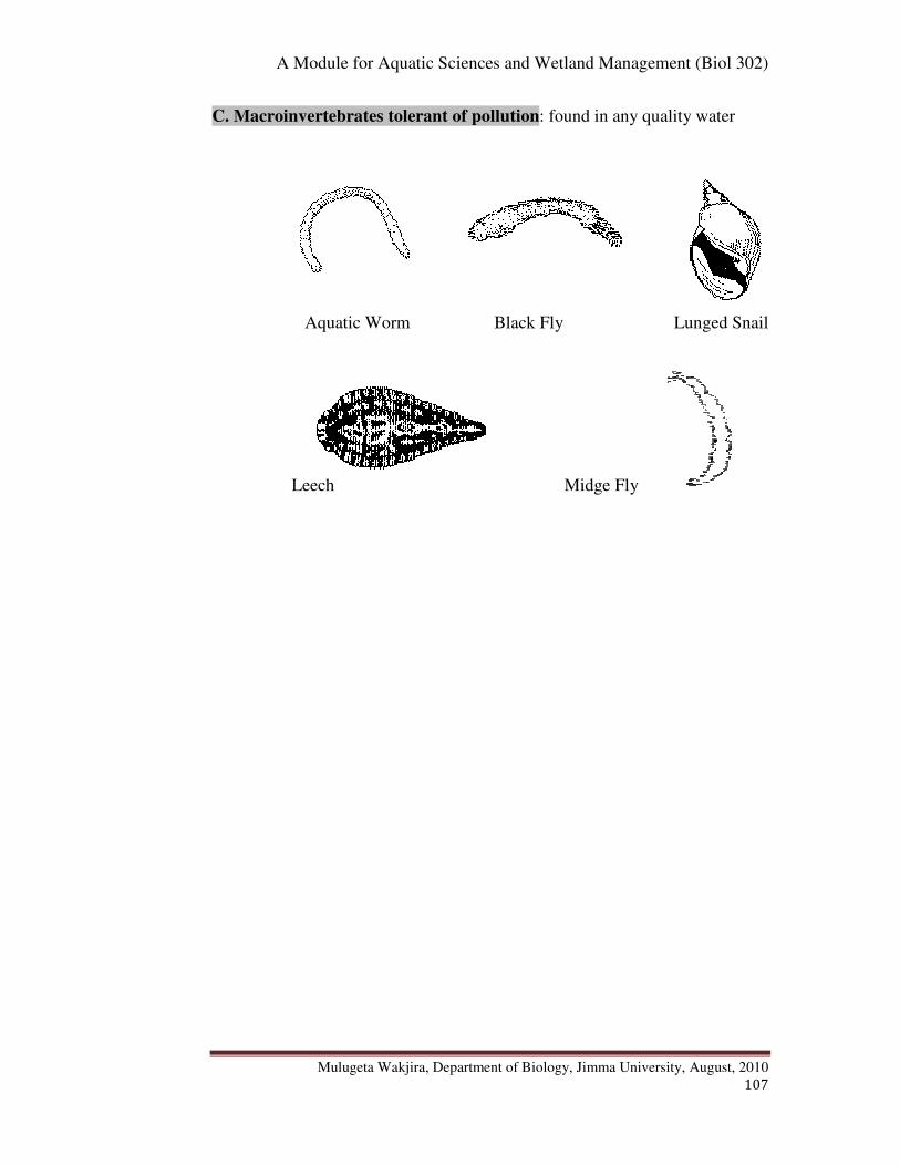
A Module for Aquatic Sciences and Wetland Management (Biol 302)
Mulugeta Wakjira, Department of Biology, Jimma University, August, 2010
107
C. Macroinvertebrates tolerant of pollution: found in any quality water
Aquatic Worm Black Fly Lunged Snail
Leech Midge Fly
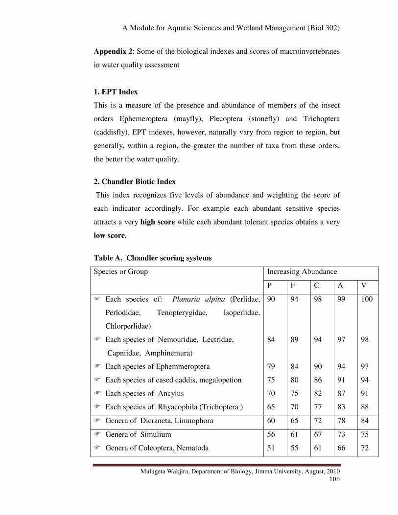
A Module for Aquatic Sciences and Wetland Management (Biol 302)
Mulugeta Wakjira, Department of Biology, Jimma University, August, 2010
108
Appendix 2: Some of the biological indexes and scores of macroinvertebrates
in water quality assessment
1. EPT Index
This is a measure of the presence and abundance of members of the insect
orders Ephemeroptera (mayfly), Plecoptera (stonefly) and Trichoptera
(caddisfly). EPT indexes, however, naturally vary from region to region, but
generally, within a region, the greater the number of taxa from these orders,
the better the water quality.
2. Chandler Biotic Index
This index recognizes five levels of abundance and weighting the score of
each indicator accordingly. For example each abundant sensitive species
attracts a very high score while each abundant tolerant species obtains a very
low score.
Table A. Chandler scoring systems
Species or Group Increasing Abundance
P F C A V
� Each species of: Planaria alpina (Perlidae,
Perlodidae, Tenopterygidae, Isoperlidae,
Chlorperlidae)
� Each species of Nemouridae, Lectridae,
Capniidae, Amphinemura)
� Each species of Ephemmeroptera
� Each species of cased caddis, megalopetion
� Each species of Ancylus
� Each species of Rhyacophila (Trichoptera )
90
84
79
75
70
65
94
89
84
80
75
70
98
94
90
86
82
77
99
97
94
91
87
83
100
98
97
94
91
88
� Genera of Dicraneta, Limnophora 60 65 72 78 84
� Genera of Simulium
� Genera of Coleoptera, Nematoda
56
51
61
55
67
61
73
66
75
72
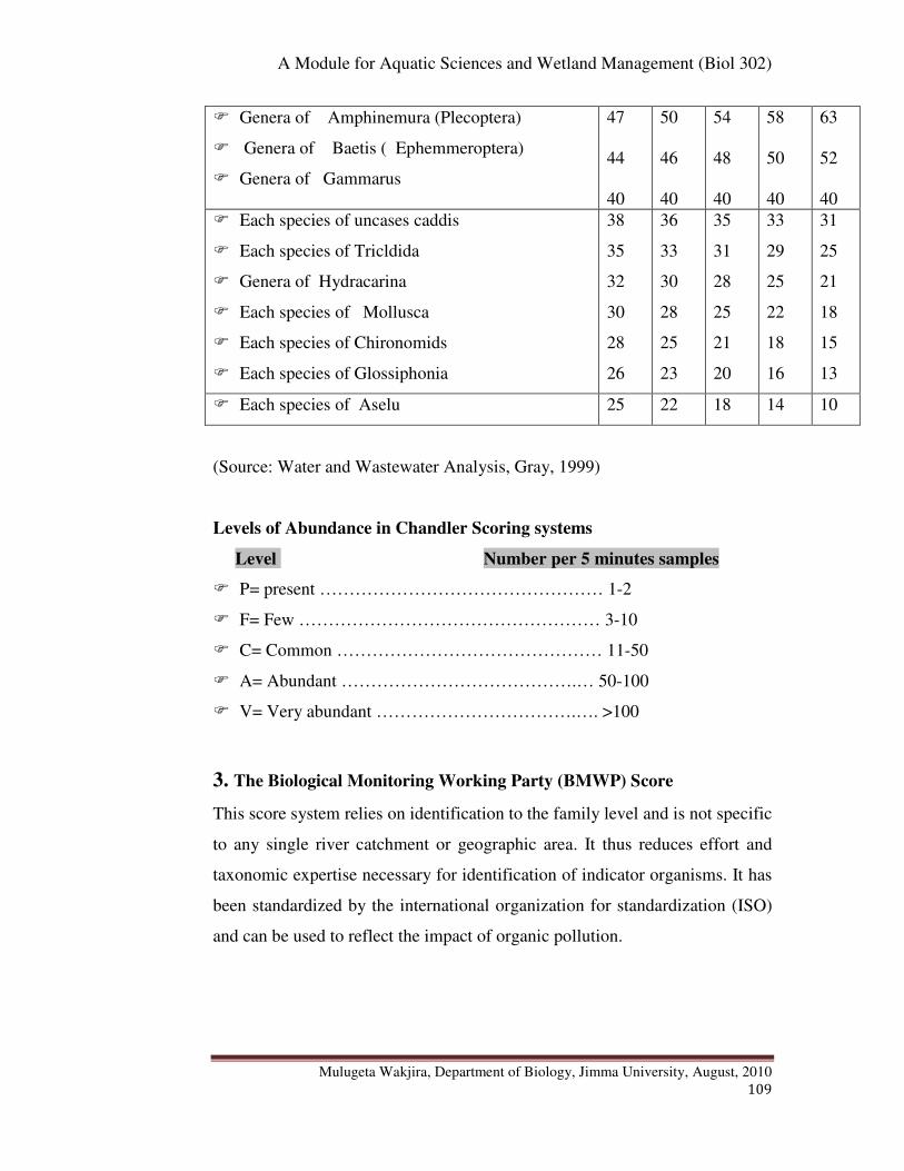
A Module for Aquatic Sciences and Wetland Management (Biol 302)
Mulugeta Wakjira, Department of Biology, Jimma University, August, 2010
109
� Genera of Amphinemura (Plecoptera)
� Genera of Baetis ( Ephemmeroptera)
� Genera of Gammarus
47
44
40
50
46
40
54
48
40
58
50
40
63
52
40
� Each species of uncases caddis
� Each species of Tricldida
� Genera of Hydracarina
� Each species of Mollusca
� Each species of Chironomids
� Each species of Glossiphonia
38
35
32
30
28
26
36
33
30
28
25
23
35
31
28
25
21
20
33
29
25
22
18
16
31
25
21
18
15
13
� Each species of Aselu 25 22 18 14 10
(Source: Water and Wastewater Analysis, Gray, 1999)
Levels of Abundance in Chandler Scoring systems
Level Number per 5 minutes samples
� P= present ………………………………………… 1-2
� F= Few …………………………………………… 3-10
� C= Common ……………………………………… 11-50
� A= Abundant ………………………………….… 50-100
� V= Very abundant …………………………….…. >100
3. The Biological Monitoring Working Party (BMWP) Score
This score system relies on identification to the family level and is not specific
to any single river catchment or geographic area. It thus reduces effort and
taxonomic expertise necessary for identification of indicator organisms. It has
been standardized by the international organization for standardization (ISO)
and can be used to reflect the impact of organic pollution.

A Module for Aquatic Sciences and Wetland Management (Biol 302)
Mulugeta Wakjira, Department of Biology, Jimma University, August, 2010
110
Examples of the family. score
Siphnuridae, Heptagenidae, Ephemeredllidae, Ephemeridae
Periidae, Chloroperlidae, Aphelocheiridae.
10
Phryganeidae, Mollanidae, Baracidae,heptoceridae, Goeridae,
Sericostomatidae.
9
Lestidae, Agriidae, Gomphidae, Aeshnidae 8
Nemouridae, Rrhyacophilidae, Polyentropodidae, Limnephilidae,
Caenidae
7
Neritidae, Viviparidae, Ancylidae, Unionidae 6
Elminthidae, Clorysomelidae, Hydrosychisae, 5
Bactidae, Sialidae, Pisciolodae. 4
Valvatidae, Hymnaeidae, Planorbidae, Sphaeriidae 3
Chironomidae 2
Oligochaeta (whole class) 1
(Source: Water and Wastewater Analysis, Gray, 1999)
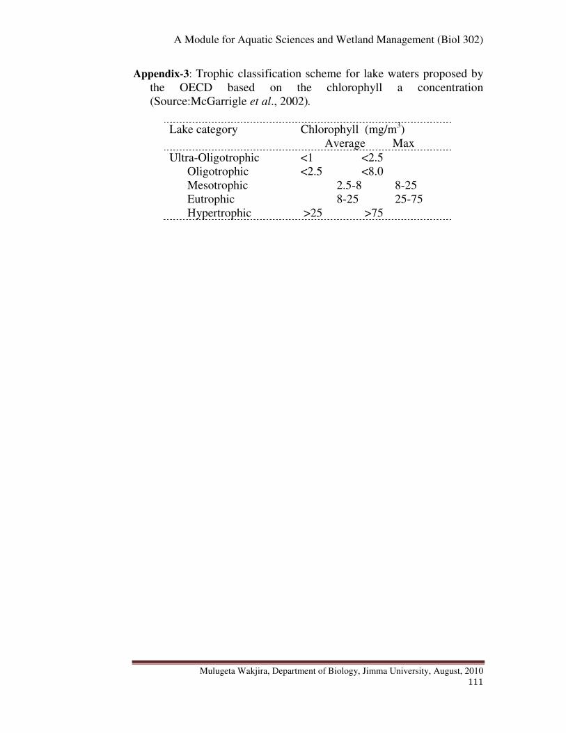
A Module for Aquatic Sciences and Wetland Management (Biol 302)
Mulugeta Wakjira, Department of Biology, Jimma University, August, 2010
111
Appendix-3: Trophic classification scheme for lake waters proposed by
the OECD based on the chlorophyll a concentration
(Source:McGarrigle et al., 2002).
Lake category Chlorophyll (mg/m3)
Average Max
Ultra-Oligotrophic <1 <2.5
Oligotrophic <2.5 <8.0
Mesotrophic 2.5-8 8-25
Eutrophic 8-25 25-75
Hypertrophic >25 >75

A Module for Aquatic Sciences and Wetland Management (Biol 302)
Mulugeta Wakjira, Department of Biology, Jimma University, August, 2010
112
Appendix-4: Some Representative Fishes in the Major Lakes and Rivers of
Ethiopia
Water body Some fish examples
Abaya Lake Barbus, Clarias, Labeo, Hydrocynus, Gara
Awassa Lake Barbus, Tilapia, Clarius
Chamo Lake Lates niloticus, Barbus, Labeo, Clarias, Gara,
Oreochromis
Tana Lake Barbus, Clarius, O. niloticus
Ziway Lake Cichilidae (e.g. Lates niloticus) and Cyprinidae
Hayq Lake Oreochromis niloticus (O. niloticus), Clarias
Awash River O. niloticus, Clarius, Barbus
Abay River Barbus, Lates niloticus (L. niloticus)
Omo/Gibe River Barbus, Labeo, Microlepidotus, Barilius,
Protopterus
Wabishebele River Barbus, Synodontis, Mormyrus
Baro River L. niloticus, O. niloticus, Hydrocyon
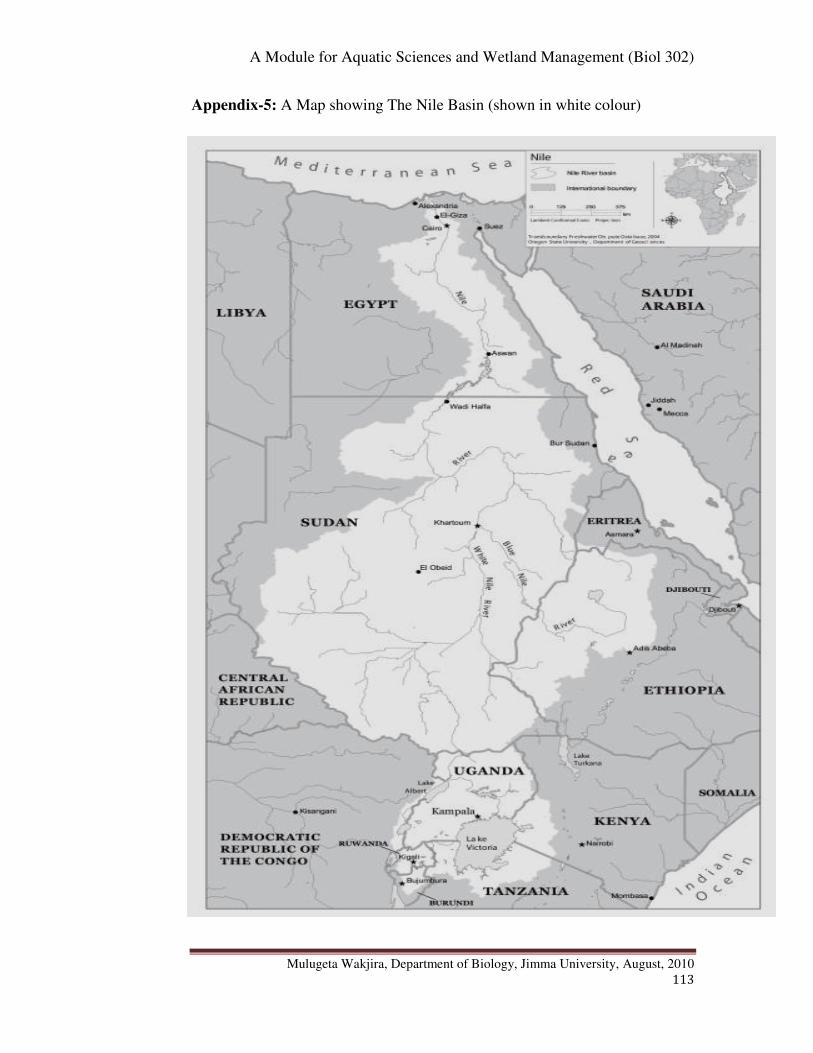
A Module for Aquatic Sciences and Wetland Management (Biol 302)
Mulugeta Wakjira, Department of Biology, Jimma University, August, 2010
113
Appendix-5: A Map showing The Nile Basin (shown in white colour)
A Module for Aquatic Sciences and Wetland Management (Biol 302)
Mulugeta Wakjira, Department of Biology, Jimma University, August, 2010
114
Appendix 6: Assignment
I. Instruction: Dear student, strictly pay attention to the following points:
� The questions in this assignment are set out of the whole chapters of the
course to check the extent of your acquirement from the course.
� You are, thus, required to be self dependent while working out all the
questions. You need to refer to the proper sections in the course module to
properly understand and give appropriate answer.
� Any attempt to copy from others is a cheating act and that will lead to the
cancellation of your results up on investigation by the instructor in charge of
the course.
II. Questions
1. Discuss the three major categories of aquatic ecosystems namely
freshwater, estuarine and marine.
2. What are wetland ecosystems? Discuss the socio-economic and
ecological values of wetlands and give examples of some of their socio-
economic benefits in Ethiopia.
3. Distinguish between the lentic and lotic ecosystems? Give examples for
each type of ecosystem. Define thermal stratification and explain how
and in which types of water bodies (lentic or lotic) it tends to develop.
4. What is eutrophication? How do anthropogenic activities exacerbate the
condition of eutrophication?
5. Define a catchment or drainage basin and list down and discuss the seven
Ethiopian drainage basins according to their respective topographic
regions. Give examples of rivers and lakes located in each basin (include
their fishery importance, endorheic and exorheic features).
6. Distinguish among the following terms that apply to zonations in lakes
and zonations in marine ecosystems and define each accordingly.
(Littoral, Limnetic, Profundal, Euphotic, Aphotic, Intertidal, Oceanic,
Pelagic, Abyssal plain, Benthic)
7. Distinguish among plankton, neckton and benthos in aquatic ecosystems
and account for the differences between holoplankton, meroplankton
A Module for Aquatic Sciences and Wetland Management (Biol 302)
Mulugeta Wakjira, Department of Biology, Jimma University, August, 2010
115
zooplankton, phagoplankton, phytoplankton and bacterioplankton. Give
examples
8. Define water pollution and distinguish between point source and diffuse
source pollution. Give examples.
9. Discuss some examples on the effects of the various pollutions and
explain how forests affect water quality and quantity.
10. Define water quality and factors that affect water quality.
11. List down and discuss any three physico-chemical and two biological
parameters used to measure water quality.
12. Distinguish between finfish and shell fish? Give examples. Which of
these are known in Ethiopian water bodies?
13. Distinguish between the agnathan and gnathostomatan fish. Give
examples.
14. What are the differences among chondrostei, holostei and teleostei bony
fishes? Which of these fish groups predominate in Ethiopian water
bodies? List down the major bony fish families important in Ethiopian in
fisheries. Give species or genus level examples.
15. How does aquaculture differ from capture fisheries?
16. Mention the previous development efforts made in Ethiopian fisheries
and its current status.
17. List down the past and present Treaties or Agreements made on the Nile
River. Which of these Agreements is said to be damaging to the
upstream riparian countries? Which agreement is said to be rational in
equitable utilization of the Nile Basin? Which Agreement is more sound
in terms of integrated water resource management to ensure equitable
and sustainable management of the Nile Basin? Discuss explicitly.
18. Distinguish between the Nile Basin Initiative and the Nile Basin
Commission?
19. What are the three factors that need to be considered in sustainable
management of wetlands?
20. What is the Ethio Wetlands and Natural Resources Association
(EWNRA)?
21. What is Ramsar Convention? Is Ethiopia a member of Ramsar Convention?
View publication statsView publication stats