Embed Size (px)
Citation preview

BasaltBasaltRock units
Cased interval
Well completionSlotted casing
Submersible pump
Water level
EXPLANATIONDefinition of terms
API - American Petroleum InstituteCPS - counts per secondDen(SS) - short-spaced densityDen(LS) - long-spaced densityGam(Nat) - natural gamma radiationNeutron - hydrogen index
Appendix A. Geophysical Logs and Construction Information for Selected Wells at the Idaho National Laboratory, Idaho
.
Explanation for all geophysical log figures:
Sediment
GAM(NAT)
0 75API
Natural Gamma
NEUTRON
0 800API
Porosity
0 100%
Neutron
DEN(SS)
65000 125000CPS
DEN(LS)
0 20000CPS
GammaWellD
epth
(ft
BLS
)
Ro
ck U
nit(
s)
ANP-9 Comments
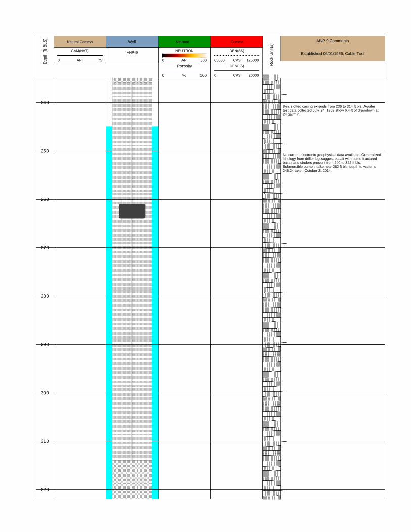
Established 06/01/1956, Cable ToolANP-9
240
250
260
270
280
290
300
310
320
8-in. slotted casing extends from 236 to 314 ft bls. Aquifertest data collected July 24, 1959 show 6.4 ft of drawdown at24 gal/min.
No current electronic geophysical data available. Generalizedlithology from driller log suggest basalt with some fracturedbasalt and cinders present from 240 to 322 ft bls.Submersible pump intake near 262 ft bls; depth to water is245.24 taken October 2, 2014.

GAM(NAT)
0 75API
Natural Gamma
NEUTRON
0 1000API
Porosity
0 100%
Neutron
DEN(SS)
65000 125000CPS
DEN(LS)
0 20000CPS
Gamma
ARA-MON-A-002 Well
WellD
epth
(ft
BLS
)
Ro
ck U
nit(
s)
ARA-MON-A-002 Comments
Established 07/29/1994; Down Hole Hammer
560
570
580
590
600
610
620
6-in. stainless steel well casing set from -2.25 to 600 ft; 5-in.well screen from 600 to 620 ft bls; 5-in. casing blank from620 to 629 ft bls. Cement from 0 to 582.5 ft bls; bentonitepellets from 582.5 to 594.4 ft bls; silica sand from 594.4 to629 ft bls.
Submersible pump intake near 604 ft bls. Depth to water is600.32 taken October 9, 2014.

GAM(NAT)
0 75API
Natural Gamma
NEUTRON
0 1300API
Porosity
0 100%
Neutron
DEN(SS)
65000 125000CPS
DEN(LS)
0 20000CPS
Gamma
MTR-Test
WellD
epth
(ft
BLS
)
Ro
ck U
nit(
s)
MTR-Test Comments
Constructed 10/13/1949; Cable Tool Drilled
460
470
480
490
500
510
520
530
540
550
560
570
580
MTR-Test has a 8-in. casing set down to 588 ft bls withperforations in casing (slotted) from 447 to 588 ft bls.
Submersible pump (5 hp) inlet set near 486 ft bls. Waterlevel data shows depth to water at 470.96 ft taken October 8,2014. Aquifer test data collected July 1, 1987 suggest 0.02 ft ofdrawdown at a pumping rate of 26 gallons per minute.

GAM(NAT)
0 75API
Natural Gamma
NEUTRON
0 800API
Porosity
0 100%
Neutron
DEN(SS)
65000 125000CPS
DEN(LS)
0 20000CPS
Gamma
NPR-Test Well
WellD
epth
(ft
BLS
)
Ro
ck U
nit(
s)
NPR-Test Well Comments
Established 7/26/1984, Air Rotary
460
470
480
490
500
510
520
530
540
550
560
570
580
590
6-inch casing from LS to 599 ft bls; milled perforations in6-in. casing extend from 500 to 535 ft bls. Aquifer test datacollected 6/09/1987 suggest about 0.25 ft of drawdown atabout 26 gallons per minute.
Submersible pump intake near 486 ft bls. Depth to water476.04 ft taken October 10, 2014.
Geology from 400 to 600 ft bls (approximated and based offNG digitized log):400 to 430 ft - sediment430 to 550 ft - basalt with sediment stringers550 to 600 ft - sediment

GAM(NAT)
0 75API
Natural Gamma
NEUTRON
0 800API
Porosity
0 100%
Neutron
DEN(SS)
90000 110000CPS
DEN(LS)
0 30000CPS
Gamma
NRF-10
WellD
epth
(ft
BLS
)
Ro
ck U
nit(
s)
NRF-10 Comments
Constructed 7/7/1995; Reverse Circ./DHH
380
390
400
410
420
430
NRF-10 has a 8-in. casing set down to 298 ft bls. NRF-10has a k-packer (6-in) starting near 279 ft bls and extends to427 ft bls; the 6-in. k-packer is screenend from 377 to 427 ftbls. NRF-10 is filled in from 427 to 450 ft bls with sluff?
Video data from July 21, 2008 suggest bottom of hole atabout 412 ft bls.
It is not clear what material is presenet between 427 ft blsand 450 ft bls. The well likely is filled in between 412 and 427ft bls?
Submersible pump (5 hp) inlet set near 408 ft bls. Waterlevel data shows depth to water at 391.88 ft taken November17, 2014.
Geology (approximate):350 to 450 ft bls - basalt

GAM(NAT)
0 100API
Natural Gamma
NEUTRON
0 800API
Porosity
0 100%
Neutron
DEN(SS)
65000 125000CPS
DEN(LS)
0 20000CPS
Gamma
NRF-9
WellD
epth
(ft
BLS
)
Ro
ck U
nit(
s)
NRF-9 Comments
Constructed 6/26/1995; Reverse Circ./DHH
380
390
400
410
420
NRF-9 has a 8-in. casing set down to 309 ft bls. NRF-9 has ak-packer (6-in) starting near 289 ft bls and extends to 422 ftbls; the 6-in. k-packer is screenend from 372 to 422 ft bls.
Submersible pump (5 hp) inlet set near 409 ft bls. Waterlevel data shows depth to water at 392.08 ft taken December4, 2014.
Geology (approximate):350 to 422 ft bls - basalt

GAM(NAT)
0 75API
Natural Gamma
NEUTRON
0 800API
Porosity
0 100%
Neutron
DEN(SS)
65000 125000CPS
DEN(LS)
0 20000CPS
Gamma
PSTF Test Well
WellD
epth
(ft
BLS
)
Ro
ck U
nit(
s)
PSTF Test Comments
Established 11/24/1957, Cable Tool
210
220
230
240
250
260
270
280
290
300
310
320
10-inch perforated casing from 190 to 315 ft bls. Aquifer testdata collected 8/21/1990 suggest 5.9 ft of drawdown at about44 gallons per minute.
Submersible pump intake near 242 ft bls. Depth to water234.3 ft taken October 2, 2014
Geology from 200 to 322 ft bls from driller log:200 to 305 - basalt305 to 315 - basalt rubble and clay315 to 322 - basalt

GAM(NAT)
0 75API
Natural Gamma
NEUTRON
0 1600API
Porosity
0 100%
Neutron
DEN(SS)
105000 130000CPS
DEN(LS)
5000 15000CPS
Gamma
RWMC M12S
WellD
epth
(ft
BLS
)
Ro
ck U
nit(
s)
RWMC-M12S Comments
Constructed July 9, 1998; Air Rotary Drilled
530
540
550
560
570
580
RWMC-M12S has a 6-in. casing set down to 568 ft bls;RWMC-M12S has a 6-in. well screen that extends from 528to 538 ft bls and from 548 to 568 ft bls then capped atbottom.
Submersible pump (5 hp) inlet set near 560 ft bls. Waterlevel data show depth to water at 542.84 ft taken October 2,2014.

GAM(NAT)
0 75API
Natural Gamma
NEUTRON
0 1600API
Porosity
0 100%
Neutron
DEN(SS)
105000 130000CPS
DEN(LS)
5000 15000CPS
Gamma
RWMC M6S
WellD
epth
(ft
BLS
)
Ro
ck U
nit(
s)
RWMC-M6S Comments
Constructed July 29, 1992; Tri-cone and DHH drilled
630
640
650
660
670
680
690
RWMC-M6S has a 6-in. casing set down to 638 ft bls;RWMC-M6S has a 6-in. well screen that extends from 638 to668 ft bls and capped at bottom.
Natural Gamma sensor not working and not displayed infigure.
Submersible pump (1.5 hp) inlet set near 663 ft bls. Waterlevel data shows depth to water at 645.83 ft taken June 7,2014.
RWMC-M6S has silica sand set between 632 and 696 ft blsand surrounds the well screen between 638 and 668 ft bls.

GAM(NAT)
0 75API
Natural Gamma
NEUTRON
0 800API
Porosity
0 100%
Neutron
DEN(SS)
65000 125000CPS
DEN(LS)
0 20000CPS
Gamma
Site-19
WellD
epth
(ft
BLS
)
Ro
ck U
nit(
s)
Site-19 Comments
Constructed in 1960; Cable Tool Drilled
475
500
525
550
575
600
625
650
675
700
725
750
775
800
825
850
Site-19 has a 10-in. casing set down to 572 ft bls; Site-19 has8-in. casing set down to 865 ft bls. Site-19 is perforatedbetween the following intervals: 472 to 512 ft bls; 532 to 572ft bls; 596 to 616 ft bls; 780 to 862 ft bls (approximate). Video data from 9/24/2002 suggest the bottom of Site-19 isat 860 ft bls.
Submersible pump (5 hp) inlet set near 486 ft bls. Waterlevel data shows depth to water at 479.83 ft taken October15, 2014. Aquifer test data collected June 24, 1987 suggest 0.08 ft ofdrawdown at a pumping rate of 25 gallons per minute.
Geology (approximate):450 to 567 ft - basalt with cinders567 to 569 ft - basalt cinders with silt569 to 664 ft - basalt with cinders664 to 674 ft - silt674 to 714 ft - basalt714 to 727 ft - clay/sand/silt727 to 865 ft - basalt

GAM(NAT)
50 100API
Natural Gamma
Neutron
0 800API
Porosity
0 100%
Neutron
USGS 1
Well
DEN(LS)
0 10000CPS
DEN(SS)
70000 82000CPS
GammaD
epth
(ft
BLS
)
Ro
ck U
nit(
s)
USGS_1 Comments
Established 12/01/1949, Cable Tool
600
610
620
630
Blank 5-in. carbon steel casing from 423 to 600 ft bls. The5-in. casing set with lead packer 10 ft inside of 6-in. casing(overlap).
Perforated 5-in. casing from 600 to 630 ft bls. Submersiblepump intake near 611 ft bls. Depth to water 595.44 ft blstaken October 1, 2014. Total estimated depth of USGS-1 is630 ft bls, open hole below 5-in. casing.

GAM(NAT)
0 75API
Natural Gamma
NEUTRON
0 800API
Porosity
0 100%
Neutron
DEN(SS)
65000 125000CPS
DEN(LS)
0 20000CPS
Gamma
USGS 100
WellD
epth
(ft
BLS
)
Ro
ck U
nit(
s)
USGS_100 Comments
Established August 19, 1974; Air Rotary Drilled
670
680
690
700
710
720
730
740
No electronic logs available for neutron and (or)gamma-gamma density; natural gamma collected down toabout 668 ft bls. Aquifer test data collected June 17, 1987suggest 0.13 ft of drawdown at a pumping rate of about 18gallons per minute. USGS-100 has 8-in. casing that extendsfrom land surface to 662 ft bls; USGS-100 has a 6-in. openhole from 662 to 750 ft bls.
Submersible pump (5 hp) inlet set near 696 ft bls; however,CWI may have performed maintenance in 2011 but no notesin USGS database. Water level data shows depth to water at688.15 ft taken October 1, 2014. Geology: 662 to 750 ft bls - basalt (firm and broken)

GAM(NAT)
0 75API
Natural Gamma
NEUTRON
0 800API
Porosity
0 100%
Neutron
DEN(SS)
65000 125000CPS
DEN(LS)
0 20000CPS
Gamma
USGS-101
WellD
epth
(ft
BLS
)
Ro
ck U
nit(
s)
USGS-101 Comments
770
780
790
800
810
820
830
840
850
860
6-in. steel casing from land surface to 774 ft bls; 4-in. steelcasing from 750 to 865 ft bls with random slottedperformations in casing starting near 765 ft bls (video takenJuly 5, 2005). Aquifer test July 2, 1987 shows 0.5 ft ofdrawdown at 8.5 gal/min.
Sediment layer caved in on top of pump and it cannot beremoved as of March, 2015.
Geology (approximate):765 to 786 ft - basalt786 to 794 ft - sediment794 to 865 ft -basalt
Pump (5hp-submersible) intake near 800 ft bls. Water level781.53 ft bls taken August 8, 2014.
Sediment sluff inside of well casing starts near 842 ft blsbased off video log taken July 5, 2005. Well currently doesnot make much water and has sand problems.

GAM(NAT)
0 125API
Natural Gamma
NEUTRON
0 800API
Porosity
0 100%
Neutron
DEN(SS)
65000 125000CPS
DEN(LS)
0 20000CPS
Gamma
USGS-106
WellD
epth
(ft
BLS
)
Ro
ck U
nit(
s)
USGS-106 Comments
Established August 28, 1980; Air-Rotary Drilled
580
590
600
610
620
630
640
650
660
670
680
690
700
710
720
730
740
750
USGS-106 has a 8-in. casing set down to 400 ft bls;USGS-106 is open hole (10-in.) from 400 to 605 ft bls andopen hole (8-in.) from 605 to 760 ft bls.
Submersible pump (5 hp) inlet set near 612 ft bls. Waterlevel data shows depth to water at 594.85 ft taken October20, 2014. Aquifer test data collected June 11, 1987 suggest 0.03 ft ofdrawdown at a pumping rate of 22 gallons per minute.
Geology (approximate):580 to 589 ft - Clay589 to 720 ft - Basalt 720 to 735 ft - Clay735 to 760 ft - Basalt
GAM(NAT)
0 125API
Natural Gamma
NEUTRON
0 800API
Porosity
0 100%
Neutron
DEN(SS)
65000 125000CPS
DEN(LS)
0 20000CPS
Gamma
USGS-112
WellD
epth
(ft
BLS
)
Ro
ck U
nit(
s)
USGS-112 Comments
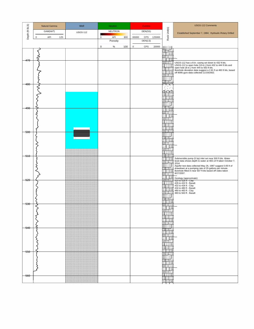
Established September 7, 1984; Hydraulic-Rotary Drilled
470
480
490
500
510
520
530
540
550
560
USGS-112 has a 8-in. casing set down to 432 ft bls;USGS-112 is open hole (10-in.) from 432 to 444 ft bls andopen hole (8-in.) from 444 to 563 ft bls.Borehole deviation data suggest a 2.81 ft at 483 ft bls, basedoff 9095 gyro-data collected 11/19/2002.
Submersible pump (5 hp) inlet set near 500 ft bls. Waterlevel data shows depth to water at 483.14 ft taken October 7,2014. Aquifer test data collected May 26, 1987 suggest 0.05 ft ofdrawdown at a pumping rate of 25 gallons per minute.Borehole filled in near 507 ft bls based off video taken8/27/2007.
Geology (approximate):420 to 426 ft - Clay426 to 432 ft - Basalt432 to 434 ft - Clay 434 to 480 ft - Basalt480 to 483 ft - Clay483 to 563 ft - Basalt

GAM(NAT)
0 75API
Natural Gamma
NEUTRON
0 800API
Porosity
0 100%
Neutron
DEN(SS)
65000 125000CPS
DEN(LS)
0 20000CPS
Gamma
USGS-12
WellD
epth
(ft
BLS
)
Ro
ck U
nit(
s)
USGS-12 Comments
Established 06/26/1950, Cable Tool
325
350
375
400
425
450
475
500
525
550
575
600
625
650
675
12-in. casing from LS to 387 ft bls; 10-in. casing from 335 to587 ft bls; 4-in. drill string stuck in hole from about 588 to 640ft bls. Casing does not appear to have perforations. Aquifertest data collected 5/15/1990 suggest about 0.44 ft ofdrawdown at about 30 gallons per minute.
Submersible pump intake near 358 ft bls. Depth to water346.52 ft taken October 6, 2014.
No current electronic geophysical log data available.
Geology from 300 to 690 ft bls from driller log (approximate):300 to 490 - basalt490 to 505 - sand505 to 515 - basalt515 to 620 - mixed sediment and basalt sections620 to 690 - mostly basalt

GAM(NAT)
0 60API
Natural Gamma
NEUTRON
0 1600API
Porosity
0 100%
Neutron
DEN(SS)
65000 125000CPS
DEN(LS)
0 15000CPS
Gamma
USGS-121
WellD
epth
(ft
BLS
)
Ro
ck U
nit(
s)
USGS-121 Comments
Completion October-1989; Air-Rotary Drilled
460
470
480
490
500
510
520
530
540
550
560
USGS-121 has a 6-in. casing set down to 449 ft bls;USGS-121 has 6-in. well screen between 449 and 475 ft blsand blank from 475 to 480 ft bls. USGS-121 was drilled to746 ft bls and cemented up between 480 and 746 ft bls.Borehole deviation data suggest a 1.68 ft at 464 ft bls, basedoff 9095 gyro-data collected 8/23/2007.
Submersible pump (5 hp) inlet set near 473 ft bls. Waterlevel data shows depth to water at 464.32 ft taken October 7,2014.
Geology (approximate):460 to 480 ft - Basalt480 to 745.8 ft - Geology not identified

GAM(NAT)
0 60API
Natural Gamma
NEUTRON
0 1600API
Porosity
0 100%
Neutron
DEN(SS)
65000 125000CPS
DEN(LS)
0 15000CPS
Gamma
USGS-123
WellD
epth
(ft
BLS
)
Ro
ck U
nit(
s)
USGS-123 Comments
Completion April 6, 1994; Air-Rotary Drilled
470
480
490
500
510
520
530
540
550
560
USGS-123 has a 6-in. stainless well casing set down to 460ft bls. USGS-123 has a 6-in. stainless screen from about 460to 514 ft bls.USGS-123 was last modified December 16, 2004.
Submersible pump (5 hp) inlet set near 481 ft bls; pumpresting on bottom of well USGS-123. Water level data showsdepth to water at 475.03 ft taken October 6, 2014. USGS-123 has drill cuttings from about 516 to 744 ft bls.
Geology (approximate):460 to 501 ft - Basalt501 to 503 ft - Clay503 to 561 ft - Basalt561 to 563 ft - Sand and rubble563 to 687 ft - Basalt687 to 690 ft - Silt690 to 740 ft - Basalt740 to 745 ft - Clay (soft)

GAM(NAT)
0 250API
Natural Gamma
Neutron
0 800API
Porosity
0 100%
Neutron
USGS-14
Well
DEN(LS)
0 30000CPS
DEN(SS)
75000 120000CPS
GammaD
epth
(ft
BLS
)
Ro
ck U
nit(
s)
USGS-14 Comments
Established 03/01/1951, Cable Tool
710
720
730
740
750
Geology from driller notes (approximate):Basalt is generally porous.
Submersible pump inlet set near 739 ft bls. Aquifer test datacollected September 14, 1989 suggest 0.08 ft of drawdown at15.9 gal/min. Depth to water 720.95 ft bls taken October 14,2014.
5-in. blank casing extends from 559 to 720 ft bls; 5-in.perforated casing extends from 720 to 747 ft bls; 5-in. blankcasing from 747 to 751.5 ft bls.

GAM(NAT)
0 75API
Natural Gamma
NEUTRON
0 800API
Porosity
0 100%
Neutron
DEN(SS)
65000 125000CPS
DEN(LS)
0 20000CPS
Gamma
USGS-18
WellD
epth
(ft
BLS
)
Ro
ck U
nit(
s)
USGS-18 Comments
Established 09/01/1951, Cable Tool
260
270
280
290
300
310
320
6-in. casing from LS to 255 ft bls; 4-in. casing from 255 to298 ft bls; 4-in. casing with perforations from 298 to 322 ftbls; 4-in. casing blank from 322 to 329 ft bls. Aquifer testdata collected 8/29/1990 suggest about 0.09 ft of drawdownat about 32 gallons per minute.
Submersible pump intake near 302 ft bls. Depth to water292.48 ft taken October 6, 2014.
Geology from 250 to 329 ft bls from driller log (approximate):250 to 264 - clay and sand264 to 285 - basalt285 to 290 - sand290 to 329 - basalt with some sand lenses described.

GAM(NAT)
10 100API
Natural Gamma
Neutron
0 800API
Porosity
0 100%
Neutron
USGS-2
Well
DEN(LS)
0 10000CPS
DEN(SS)
75000 90000CPS
GammaD
epth
(ft
BLS
)
Ro
ck U
nit(
s)
USGS-2 Comments
Established 12/01/1949, Cable Tool
660
670
680
690
Blank 6-in. carbon steel casing from LS to 434 ft bls; 5-in.casing set from 427 to 704 ft bls; perforations from 675 to696 ft bls.
Perforated 5-in. casing from 675 to 696 ft bls. Submersiblepump intake near 685 ft bls. Depth to water 670.16 ft blstaken October 1, 2014. Total estimated depth of USGS-2 is699 ft bls (video 8/5/2002). Aquifer test data suggest 4.5 ft ofdrawdown at about 15 gallons per minute rate.

GAM(NAT)
0 75API
Natural Gamma
NEUTRON
0 800API
Porosity
0 100%
Neutron
DEN(SS)
65000 125000CPS
DEN(LS)
0 20000CPS
GammaWellD
epth
(ft
BLS
)
Ro
ck U
nit(
s)
USGS-31 Comments
Established 06/11/1953, Cable ToolUSGS-31
250
260
270
280
290
300
310
320
330
340
350
360
370
380
390
400
410
420
8-in. slotted casing extends from 285 to 305 ft bls; 10.25-in.open hole from 306 to 428 ft bls. Total well depth is notknown where this well was used as a seismic shot hole in the1960's and likely had damage to the open hole section.Aquifer test data collected July 10, 1953 show 1.7 ft ofdrawdown at a discharge rate of 280 gal/min.
No current electronic geophysical data available.Submersible pump intake near 284 ft bls; depth to water268.76 ft bls taken October 2, 2014.
Generalized lithology from driller log starting near 250 ft bls:250 to 305 ft - Basalt, dark gray and red305 to 345 ft - Basalt dense 345 to 350 ft - Vesicular basalt350 to 373 ft - Dense basalt373 to 402 ft - Vesicular to very vesicular basalt402 to 415 ft - porous red lava (cinders?)415 to 429 ft - gray lava

GAM(NAT)
0 75API
Natural Gamma
NEUTRON
0 800API
Porosity
0 100%
Neutron
DEN(SS)
65000 125000CPS
DEN(LS)
0 20000CPS
GammaWellD
epth
(ft
BLS
)
Ro
ck U
nit(
s)
USGS-32 Comments
Established 06/24/1953, Cable ToolUSGS-32
310
320
330
340
350
360
370
380
390
6-in. slotted casing extends from 306 to 324 ft bls; 5.5-in.open hole from 324 to 392 ft bls. Aquifer test data collectedAugust 24, 1990 show 0.01 ft of drawdown at a dischargerate of 31 gal/min.
No current electronic geophysical data available.Submersible pump intake near 322 ft bls; depth to water306.85 ft bls taken October 2, 2014.
Generalized lithology from driller log starting near 250 ft bls:305 to 350 ft - Basalt, dark gray and red350 to 372 ft - Vesicular basalt372 to 392 ft - Clay material (yellow and blue in color)Well is caved near 374 ft bls?

GAM(NAT)
0 75API
Natural Gamma
NEUTRON
0 800API
Porosity
0 100%
Neutron
DEN(SS)
65000 125000CPS
DEN(LS)
0 20000CPS
Gamma
USGS-39
WellD
epth
(ft
BLS
)
Ro
ck U
nit(
s)
USGS-39 Comments
Established 12/01/1955, Cable Tool
480
490
500
510
520
530
540
550
560
570
6-in. open hole from 48 ft to 572 ft bls. USGS-39 has had lotsof sediment problems and well is currently sloughed in toabout 493 ft bls.
Submersible pump intake near 487 ft bls. Depth to water485.66 ft bls taken July 17, 2014. Aquifer test data suggest0.01 ft of drawdown at about 23 gallons per minute rate.Geology not very well noted in site schedule.

GAM(NAT)
0 100API
Natural Gamma
NEUTRON
0 1600API
Porosity
0 100%
Neutron
DEN(SS)
65000 125000CPS
DEN(LS)
0 20000CPS
Gamma
USGS-47
WellD
epth
(ft
BLS
)
Ro
ck U
nit(
s)
USGS-47 Comments
Established March 21, 1958; Cable Tool Drilled
470
480
490
500
510
520
530
540
550
560
570
580
590
600
610
620
630
640
650
USGS-47 has a 6-in. open hole from 458 to 651 ft bls.
Submersible pump (5 hp) inlet set near 486 ft bls. Waterlevel data shows depth to water at 469.00 ft taken October12, 2010. Geology from natural gamma log: 460 to 534 ft bls - basalt (firm and broken)534 to 542 ft bls - sediment layer542 to 651 ft bls - basaltVideo taken 4/18/2005 suggest downward flow occurs belowsediment zone, after about 550 ft bls.

GAM(NAT)
0 75API
Natural Gamma
NEUTRON
0 800API
Porosity
0 100%
Neutron
DEN(SS)
65000 125000CPS
DEN(LS)
0 20000CPS
Gamma
USGS-5
WellD
epth
(ft
BLS
)
Ro
ck U
nit(
s)
USGS-5 Comments
Established 12/01/1949, Cable Tool
470
480
490
Blank 6-in. carbon steel casing from LS to 475 ft bls;perforations from 475 to 497 ft bls.No current electronic geophysical log data.
Submersible pump intake near 488 ft bls. Depth to water480.41 ft bls taken October 7, 2014. Total estimated depth ofUSGS-5 is 500 ft bls. Aquifer test data suggest 17.1 ft ofdrawdown at about 5.4 gallons per minute rate.Geology (based off old natural gamma log):basalt - 450 to 458 ft blssediment - 458 to 462 ft blsbasalt - 462 to 490 ft blssediment - 490 to 500 ft bls

GAM(NAT)
0 75API
Natural Gamma
NEUTRON
0 800API
Porosity
0 100%
Neutron
DEN(SS)
65000 125000CPS
DEN(LS)
0 20000CPS
Gamma
USGS-58
WellD
epth
(ft
BLS
)
Ro
ck U
nit(
s)
USGS-58 Comments
Established February 4, 1961; Cable Tool Drilled
460
470
480
490
500
USGS-58 has a 6-in. casing set down to 218 ft bls; USGS-58is open hole from 218 to 503 ft bls. Well was deepened in1961 from 475 to 503 ft bls.
Submersible pump (5 hp) inlet set near 483 ft bls. Waterlevel data shows depth to water at 472.70 ft taken October 8,2014. Aquifer test data collected June 18, 1987 suggest 0.08 ft ofdrawdown at a pumping rate of 25 gallons per minute.
GAM(NAT)
0 75API
Natural Gamma
NEUTRON
0 1600API
Porosity
0 100%
Neutron
DEN(SS)
65000 125000CPS
DEN(LS)
0 20000CPS
Gamma
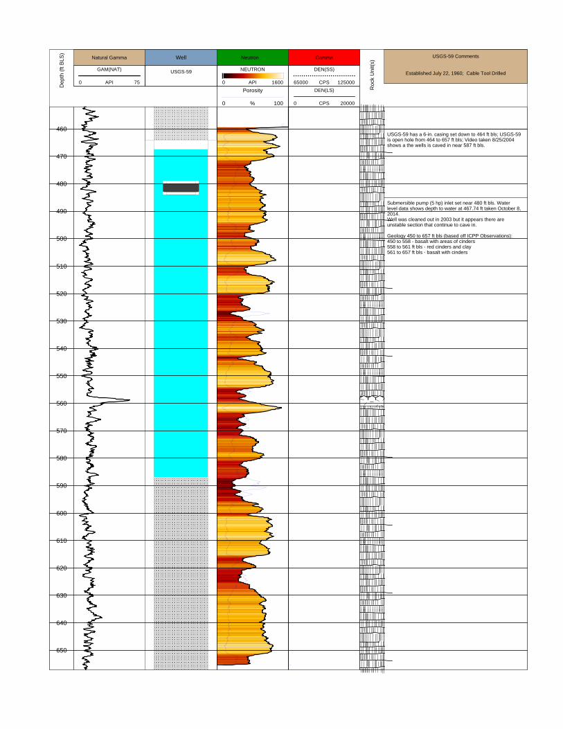
USGS-59
WellD
epth
(ft
BLS
)
Ro
ck U
nit(
s)
USGS-59 Comments
Established July 22, 1960; Cable Tool Drilled
460
470
480
490
500
510
520
530
540
550
560
570
580
590
600
610
620
630
640
650
USGS-59 has a 6-in. casing set down to 464 ft bls; USGS-59is open hole from 464 to 657 ft bls; Video taken 8/25/2004shows a the wells is caved in near 587 ft bls.
Submersible pump (5 hp) inlet set near 480 ft bls. Waterlevel data shows depth to water at 467.74 ft taken October 8,2014. Well was cleaned out in 2003 but it appears there areunstable section that continue to cave in.
Geology 450 to 657 ft bls (based off ICPP Observations):450 to 558 - basalt with areas of cinders558 to 561 ft bls - red cinders and clay561 to 657 ft bls - basalt with cinders
GAM(NAT)
0 150API
Natural Gamma
NEUTRON
0 800API
Porosity
0 100%
Neutron
DEN(SS)
65000 125000CPS
DEN(LS)
0 20000CPS
Gamma
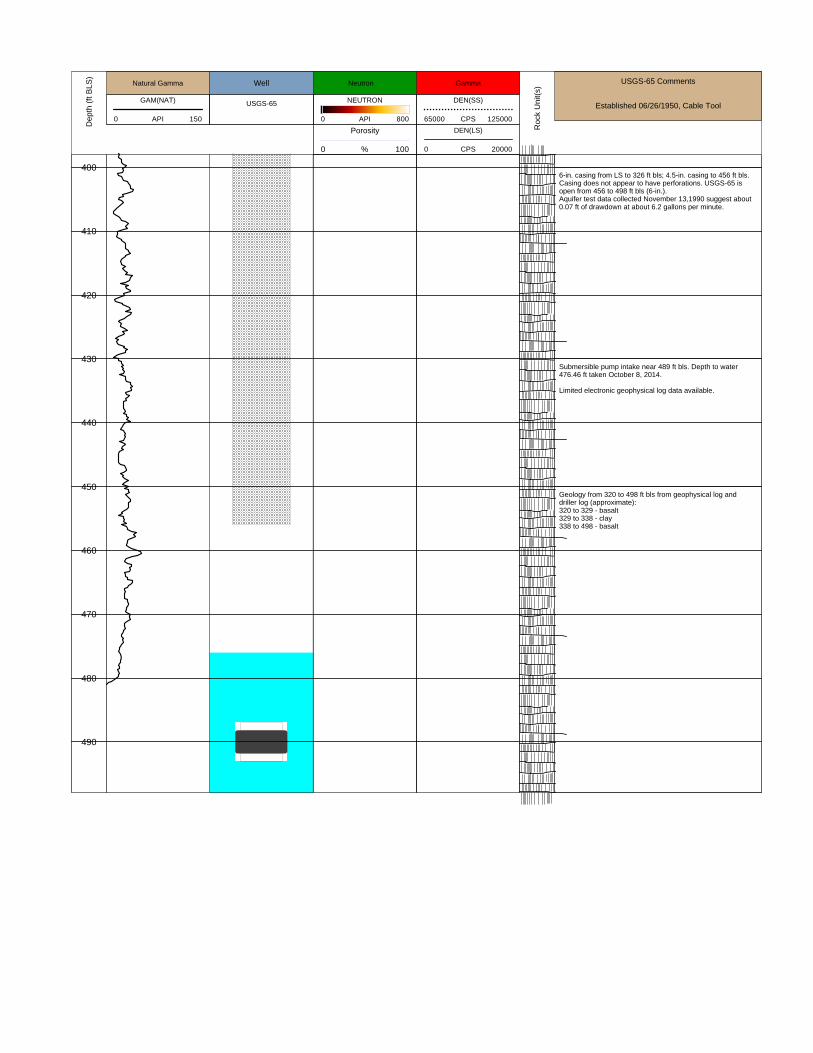
USGS-65
WellD
epth
(ft
BLS
)
Ro
ck U
nit(
s)
USGS-65 Comments
Established 06/26/1950, Cable Tool
400
410
420
430
440
450
460
470
480
490
6-in. casing from LS to 326 ft bls; 4.5-in. casing to 456 ft bls.Casing does not appear to have perforations. USGS-65 isopen from 456 to 498 ft bls (6-in.). Aquifer test data collected November 13,1990 suggest about0.07 ft of drawdown at about 6.2 gallons per minute.
Submersible pump intake near 489 ft bls. Depth to water476.46 ft taken October 8, 2014.
Limited electronic geophysical log data available.
Geology from 320 to 498 ft bls from geophysical log anddriller log (approximate):320 to 329 - basalt329 to 338 - clay338 to 498 - basalt

GAM(NAT)
0 75API
Natural Gamma
NEUTRON
0 800API
Porosity
0 100%
Neutron
DEN(SS)
65000 125000CPS
DEN(LS)
0 20000CPS
Gamma
USGS-7
WellD
epth
(ft
BLS
)
Ro
ck U
nit(
s)
USGS-7 Comments
Established 04/04/1950, Cable Tool
250
275
300
325
350
375
400
425
450
475
500
525
550
575
600
6-inch casing from LS to 252 ft bls; milled perforations in6-in. casing extend from 239 to 252 ft bls. USGS-7 notes suggest 6-in. casing was removed and isopen hole from 252 to about 775 ft bls. USGS-7 was drilled to 1,200 ft; 5.5-in. from 775 to about 950ft, 3.5-in. from about 950 to 1,200 ft bls. Aquifer test data collected 8/31/1990 suggest about 1 ft ofdrawdown at about 48 gallons per minute.
This well was modified after initial construction.
Submersible pump intake near 242 ft bls. Depth to water237.24 ft taken October 2, 2014.
Geology from 230 to 1,200 ft bls from driller log(approximate):230 to 680 - basalt680 to 685 - sand and gravel685 to 755 - basalt755 to 775 - mixed sediment and basalt775 to 900 - basalt900 to 1,000 - sediment with basalt 1,000 to 1,040 - basalt1,040 to 1,060 - sand1,060 to 1,080 - basalt1,080 to 1,090 - sand1,090 to 1,200 - basalt with missing intervals

GAM(NAT)
0 75API
Natural Gamma
NEUTRON
0 800API
Porosity
0 100%
Neutron
DEN(SS)
65000 125000CPS
DEN(LS)
0 20000CPS
Gamma
USGS-76
WellD
epth
(ft
BLS
)
Ro
ck U
nit(
s)
USGS-76 Comments
Established February 23, 1962; Cable Tool Drilled
460
470
480
490
500
510
520
530
540
550
560
570
580
590
600
610
620
630
640
650
660
670
680
690
700
710
USGS-76 has a 6-in. casing set down to 457 ft bls; USGS-76is open hole from 457 to 718 ft bls.
Submersible pump (5 hp) inlet set near 502 ft bls. Waterlevel data shows depth to water at 484.91 ft taken October 8,2014. Aquifer test data collected June 10, 1987 suggest 0.02 ft ofdrawdown at a pumping rate of about 25 gallons per minute.
Geology from 450 to 718 ft bls (approximate):450 to 528 ft - Basalt528 to 534 ft - Sand and clay534 to 717 ft - Basalt with areas of cinders

GAM(NAT)
0 75API
Natural Gamma
NEUTRON
0 1500API
Porosity
0 100%
Neutron
USGS-84
Well
DEN(LS)
9000 75000CPS
DEN(SS)
100000 150000CPS
GammaD
epth
(ft
BLS
)
Ro
ck U
nit(
s)
USGS-84 Comments
Established January 1, 1962; Cable Tool
490
500
USGS-84 has 6-in. casing that extends down to 324 ft blsand 4-in. casing that extends down to 420 ft bls. USGS-84 isopen hole (6-in.) from 420 to 505 ft bls.
Submersible pump inlet set near 498 ft bls. Depth to water493.00 ft bls taken October 22, 2014.
Geology approximated:475 to 505 ft - basalt with cinders in areas

GAM(NAT)
0 75API
Natural Gamma
NEUTRON
0 800API
Porosity
0 100%
Neutron
DEN(SS)
65000 125000CPS
DEN(LS)
0 20000CPS
Gamma
USGS-85
WellD
epth
(ft
BLS
)
Ro
ck U
nit(
s)
USGS-85 Comments
Established August 9, 1962; Cable Tool Drilled
480
490
500
510
520
530
540
550
560
570
580
590
600
610
USGS-85 has a 6-in. casing set down to 522 ft bls; USGS-85is open hole from 522 to 614 ft bls. Well video taken in 1993suggest the well is filled in below about 614 ft bls.
Submersible pump (5 hp) inlet set near 514 ft bls. Waterlevel data shows depth to water at 494.68 ft taken October 8,2014. Aquifer test data collected September 12, 1990 suggest 0.00ft of drawdown at a pumping rate of 22 gallons per minute.
Geology approximate:475 to 518 ft - basalt518 to 522 ft - sand and basalt (drive shoe set throughsediment)522 to 613 - basalt with areas of cinders613 to 619 - clay (sluffed in near 613 ft bls)

GAM(NAT)
0 60API
Natural Gamma
USGS-86
Well
Neutron
0 2900API
Porosity
0 100%
Neutron
DEN(LS)
10000 80000CPS
DEN(SS)
75000 100000CPS
GammaD
epth
(ft
BLS
)
Ro
ck U
nit(
s)
USGS-86 Comments
Established October 1, 1966, Cable Tool
650
660
670
680
690
8-in. casing extends down to 48 ft and USGS-86 is open hole(8-in.) between 48 and 691 ft bls.
Submersible pump inlet set near 673 ft bls. Depth to water656.49 ft bls taken October 22, 2014. USGS-86 wasconstructed as 8-in. open hole from 48 to 691 ft bls. Aquifertest conducted August 4, 1987 suggest USGS-86 showsdrawdown of 3.39 ft at a discharge rate of 19.0 gal/min. Totalwell depth near 690 ft bls based of video taken September17, 2013.

GAM(NAT)
0 75API
Natural Gamma
NEUTRON
0 800API
Porosity
0 100%
Neutron
DEN(SS)
65000 125000CPS
DEN(LS)
0 20000CPS
Gamma
USGS-87
WellD
epth
(ft
BLS
)
Ro
ck U
nit(
s)
USGS-87 Comments
Established September, 1971; Cable Tool Drilled
580
590
600
610
620
630
640
650
660
USGS-87 has a 6-in. casing set down to 585 ft bls; USGS-87was deepened in 1974 and has 4-in. casing set from 568 to673 ft bls with slotted perforations.
Submersible pump (1.5 hp) inlet set near 610 ft bls. Waterlevel data shows depth to water at 595.31ft taken April 17,2014.Aquifer test data collected October 17, 1988 suggest 0.3 ft ofdrawdown at a pumping rate of 6 gallons per minute.
Geology approximate:575 to 600 ft - basalt600 to 610 ft - sand and basalt (drive shoe set throughsediment)610 to 630 - basalt with areas of cinders630 to 640 - sand640 to 673 - basalt with areas of cinders

GAM(NAT)
0 75API
Natural Gamma
Neutron
0 2900API
Porosity
0 100%
Neutron
USGS-9
Well
DEN(LS)
10000 80000CPS
DEN(SS)
75000 100000CPS
GammaD
epth
(ft
BLS
)
Ro
ck U
nit(
s)
USGS-9 Comments
Established 12/10/1951, Cable Tool
575
580
585
590
595
600
605
610
615
620
625
630
635
640
645
650
6-in. casing extends down to 618 ft bls. Sediment layersestimated from natural gamma logs near 594 and 609 ft bls.
Submersible pump inlet set near 632 ft bls. 6-in. perforatedcasing extends from 618 to 648 ft bls. Aquifer test datacollected July 30, 1987 suggest 0.04 ft of drawdown at 18.7gal/min. Depth to water 614.05 ft bls taken October 22, 2014.
6-in. blank casing extends from 648 to 652 ft bls. 6-in. openhole described from 652 to 654 ft bls; however, sluff materialobserved in video near 650 ft bls (July 1, 2003).
GAM(NAT)
0 140API
Natural Gamma
NEUTRON
0 1000API
Porosity
0 100%
Neutron
DEN(SS)
80000 140000CPS
DEN(LS)
1000 10000CPS
Gamma
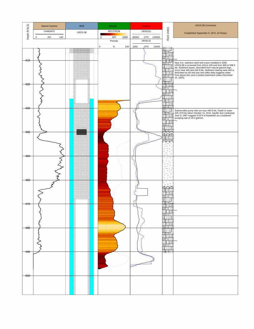
USGS-98
WellD
epth
(ft
BLS
)
Ro
ck U
nit(
s)
USGS-98 Comments
Established September 9, 1973, Air Rotary
410
420
430
440
450
460
470
480
490
500
New 4-in. stainless steel well sceen installed in 2005.USGS-98 is screened from 418 to 428 and from 468 to 508 ftbls. Sediment layers, described from natural gamma logs,occur near 440 and 444 ft bls. Sediment starting near 444 isdescribed as silt and clay and video data suggests waterfrom above this zone is pulled downward (video December16, 2003).
Submersible pump inlet set near 440 ft bls. Depth to water425.79 ft bls taken October 14, 2014. Aquifer test conductedJune 5, 1987 suggest 0.03 ft of drawdown at a sustainedpumping rate of 18.3 gal/min.
GAM(NAT)
0 75API
Natural Gamma
NEUTRON
0 800API
Porosity
0 100%
Neutron
DEN(SS)
65000 125000CPS
DEN(LS)
0 20000CPS
Gamma
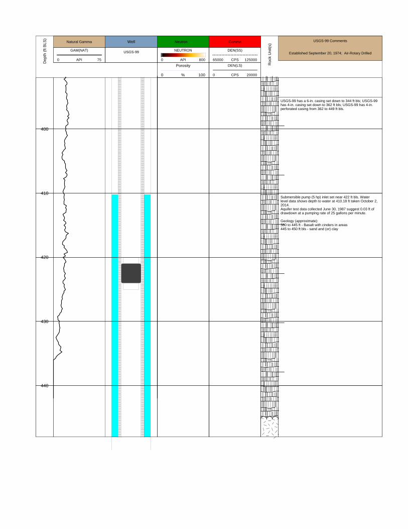
USGS-99
WellD
epth
(ft
BLS
)
Ro
ck U
nit(
s)
USGS-99 Comments
Established September 20, 1974; Air-Rotary Drilled
400
410
420
430
440
USGS-99 has a 6-in. casing set down to 344 ft bls; USGS-99has 4-in. casing set down to 362 ft bls; USGS-99 has 4-in.perforated casing from 362 to 449 ft bls.
Submersible pump (5 hp) inlet set near 422 ft bls. Waterlevel data shows depth to water at 410.18 ft taken October 2,2014. Aquifer test data collected June 30, 1987 suggest 0.03 ft ofdrawdown at a pumping rate of 25 gallons per minute.
Geology (approximate):380 to 445 ft - Basalt with cinders in areas445 to 450 ft bls - sand and (or) clay


![ars.els-cdn.com · Web view[89] HDPE 125000 350 3.55 60 0.5%Pt/SO 4 /ZrO 2 2:1 64.7s [89] HDPE 125000 350 3.55 60 0.5%Pt/SO 4 /ZrO 2 5:1 55.1s [89] HDPE 125000 375 8.38 25 2.0%Ni/ZrO](https://img.dokumen.tips/doc/110x75/5f57a2ddb78beb754767c28c/arsels-cdncom-web-view-89-hdpe-125000-350-355-60-05ptso-4-zro-2-21-647s.jpg)