Embed Size (px)
Citation preview

1 ICA Standards Commission DRAFT
AN INITIAL FORMAL MODEL FOR
SPATIAL DATA INFRASTRUCTURES
Jan Hjelmager1, Harold Moellering, Tatiana Delgado, Antony Cooper, Abbas
Rajabifard, Petr Rapant, David Danko, Michel Huet, Dominique Laurent, Henri
Aalders, Adam Iwaniak, Paloma Abad, Ulrich Düren and Alexander Martynenko
Kort & Matrikelstyrelsen, Rentemestervej 8, Copenhagen, DK-2400 NV, Denmark.
Department of Geography, Ohio State University, Columbus, OH, 43210, USA
National Commission of the SDI of Cuba, Calle 6 No. 301 Esq. 3ra, Miramar, La Habana 11300, Cuba
Logistics and Quantitative Methods, CSIR, PO Box 395, Pretoria, 0001, South Africa
Department of Geomatics, University of Melbourne, Melbourne, Victoria 3010, Australia
Institute of Geoinfomatics, VSB-Technical University of Ostrava, 17. listopadu 15, Ostrava-Poruba,
Czech Republic
Environmental Systems Research Institute, Inc, 8620 Westwood Center Drive, Vienna, VA 22182-2214,
USA
International Hydrographic Bureau, 4 quai Antoine 1er, Monaco
Institut Géographique National, 4 Rue Pasteur, 94165 Saint Mandé, France
Dept. Burgerlijke bouwkunde, Kasteelpark Arenberg 40, B-3001 Heverlee, Belgium
Katedra Geodezji i Fotogrametrii Akademii Rolniczej we Wrocławiu, ul. Grunwaldzka 53, 50-357
Wrocław Poland
Instituto Geográfico Nacional, General Ibañez de Ibero 3, 28003 Madrid, Spain
Landesvermessungsamt Nordrhein-Westfalen, Muffendorfer Strasse 19-21, 53177 Bonn, Germany
Institute of Informatics Problems, Russian Academy of Sciences, 44, Vavilova st. Moscow, 117333,
Russia
© Copyright ICA Spatial Data Standards Commission, 2006. All rights reserved.
1 Corresponding author: Jan Hjelmager. Tel: +45 3587 5050. Fax: +45 3587 5051. Email: [email protected]

2
ABSTRACT
The Commission on Spatial Data Standards of the International Cartographic
Association (ICA) is working on defining formal models and technical characteristics of
Spatial Data Infrastructures (SDI). To date, this work has been restricted to the
Enterprise and Information Viewpoints from the ISO Reference Model for Open
Distributed Processing (RM-ODP) standard. The Commission has developed models
for these two viewpoints. These models describe how the different parts of an SDI fit
together in the viewpoints in question. These models should be seen as a contribution
towards the overall model of the SDI and its technical characteristics.
During the model development process, the roles of the different Actors in an SDI in the
Enterprise and Information Viewpoints have also been identified in Use Case diagrams
of an SDI. All the models have been developed using the Unified Modeling Language
(UML).
Keywords: Spatial Data Infrastructure, SDI, Spatial Data, Analytical Cartography,
Reference Model, Enterprise Viewpoint, Information Viewpoint, Unified
Modeling Language, UML.
1. INTRODUCTION
The growing need to organise geospatial data across different disciplines and
organisations has resulted in the development and implementation of spatial data

3
infrastructures (SDI) and the theory and concepts behind them. An SDI is an evolving
concept about facilitating and coordinating the exchange and sharing of spatial data
between stakeholders from different levels in the spatial data community. With this in
mind, many countries are developing SDIs to manage and utilise better their spatial data
assets by taking a perspective that starts at a local level and proceeds through state,
national and regional levels to the global (GSDI) level. This has resulted in the
development of different forms of SDI at and between these levels. Increasingly, these
countries are finding it necessary to cooperate with other countries to develop multi-
national SDIs (regional and global SDIs) to assist in decision-making that have
important impacts across national boundaries.
In order to get an overview of the issues concerning modelling an SDI, one of our first
tasks was to review the different reference models applicable to the SDI. The
architecture reference model used by the International Organization for Standardisation
(ISO) Technical Committee (TC) for Geographic Information/Geomatics, ISO/TC 211,
Geographic Information – Reference model [ISO 19101:2002]; the Open Geospatial
Consortium’s (OGC) Reference Model (ORM) [OGC, 2003]; and the Geospatial
Interoperability Reference Model (GIRM) [Federal Geographic Data Committee 2003],
were the main reference models reviewed and discussed. The base reference model
used in all of these reference models is the Reference Model of Open Distributed
Processing (RM-ODP) [ISO/IEC 10746:1995], which defines a framework comprising
five viewpoints: Enterprise, Information, Computation, Engineering and Technology.
The RM-ODP model allows one to describe complex distributed systems, which
provides a framework of different levels of abstraction [Delgado 2005].
4
The reference model provides an overall frame of reference that organises the
constituent parts of an SDI into a coherent whole. The RM-ODP model can describe
most of its components without prescribing an implementation. The choice of using the
RM-ODP concepts to model SDIs was motivated by RM-ODP being an international
standard already, and that it is a good base to facilitate understanding of SDIs.
The concept of an SDI is very broad, encompassing all kinds and forms of spatial
information. The concept of a ”Distributed Geolibrary”, as described by the USA
National Research Council [NRC, 1999], is really a special case that can exist under the
overall concept of a Spatial Data Infrastructure. In this 1999 report, the writers
recognize the expanding technological potential provided by the World Wide Web
(WWW), when it comes to designing and implementing an SDI. It turns out that the
WWW is an excellent vehicle on which to base the physical communication structure of
the implementations that come out of such SDI designs.
As such, this work to develop a conceptual model of an SDI is based on the realization
that an SDI can be viewed as a set of networked, and potentially interlocked, spatial
databases. Here, these geospatial databases are digital collections of data that represent
features and their characteristics as they exist in the real or an imaginary world. Hence,
such a geospatial database is really a complex version of a type of Virtual Map, as
defined by Moellering [1980, 1984, 2000]. Here, the defining concept of a Virtual Map
is that the geospatial information is digital and does NOT have a physical hard copy
reality. When one is in the Virtual Map domain of the SDI, as much of it really is, then

5
one is also usually involved with the Deep Structure [Nyerges, 1980] of the data and
information relationships that exist below the visible surficial level.
When one considers the Geospatial databases upon which an SDI is built, it should be
realized that these are really various flavours of Virtual Maps, in this case Virtual 3. It
should be clear to the reader that these sorts of spatial databases are usually easily
transformable into other forms of Virtual Maps, for example, when information from a
Virtual 3 geospatial database is extracted and then visualized on a display screen as a
geographical image (a Virtual 1 Map). These Real and Virtual Map transformations are
an expansion of the earlier map transformation concepts from Tobler [1979]. For an
overall review of these spatial concepts and many others from Analytical Cartography,
please see Moellering [2000]. These concepts discussed above are consistent with those
presented by Groot and McLaughlin [2000] in their book on the geospatial data
infrastructure.
The motivation to undertake this work is to obtain a multi-perspective description of
Spatial Data Infrastructures, as part of the terms of reference for 2003-2007 for the
Spatial Data Standards Commission of the International Cartographic Association
(ICA). These are enunciated as follows:
• To develop a conceptual model of the Spatial Data Infrastructure (SDI)
using the Unified Modeling Language (UML) [ISO/IEC 19501:2005]
and associated modelling concepts, working in the areas of science,
technology and standards, at the global, regional and national levels.

6
• To define the technical characteristics of the SDI and concepts for
appropriate data sets for the SDI. [ICA 2003]
Our work began by developing a preliminary high-level model of an SDI, identifying
some of the Actors, Use Cases and Classes, described using UML [Cooper et al 2003].
Subsequently, the ICA Commission on Spatial Data Standards has exploited the first
two RM-ODP viewpoints to describe an SDI: the Enterprise and Information
Viewpoints. Future work will examine the Computation Viewpoint of the SDI
Reference Model.
Different notations may be chosen as appropriate to reflect the requirements of the
viewpoints in the RM-ODP. These notations may be natural, formal, textual or
graphical. In the following work, UML has been used as the main notation language to
express the two viewpoints.
2. SDI – NATURE AND COMPONENTS
The need to create multi-participant, decision-supported environments to address the
issues of sustainable development and improving quality of life creates a growing need
to organise spatial data across disciplines and organisations through different forms of
SDI. An SDI is fundamentally a concept about facilitating and coordinating the
exchange and sharing of spatial data between stakeholders from different jurisdictional
levels in the spatial data community. In principle, SDIs allow the sharing of data, which
is extremely useful, as it enables users to save time, effort and resources when trying to
7
acquire new datasets by avoiding duplication of expenses associated with generation,
integration and maintenance of spatial datasets. To enable this, an SDI encompasses the
policies, technologies, standards and human resources necessary for the effective
collection, management, access, delivery and utilisation of geospatial data for a specific
jurisdiction or community [Global Spatial Data Infrastructure 2004].
It is the needs of the user community that drive SDI development. With this in mind,
the design of any SDI requires understanding the nature of the concept, the contributing
components and the impact of global drivers such as globalisation, sustainable
development, economic reform, political unrest and war, urbanisation, environmental
awareness, and human rights. These present significant influences on the changing
spatial data relationships within the context of SDI jurisdictions which in turn affect the
resulting spatial data industry environment and SDI vision, in particular the partnership
concept. There has been a trend for countries to expand their efforts in developing SDIs
through partnerships, as data sharing is crucial to the success of SDIs.
There are a number of important factors and issues related to SDI development from
conceptual, technical, socio-technical, political, institutional and financial perspectives.
Therefore, the challenge of designing, building, implementing, and maintaining an SDI
draws on many different disciplines and requires examination of such factors and issues.
3. CURRENT STATUS OF SDI INITIATIVES
With increasing frequency, many countries throughout the world are developing SDIs to
manage and utilise their spatial data assets better. These countries are also finding it

8
necessary to cooperate with other countries to develop regional and global
(multinational) SDIs to assist in decision-making that has important impacts across
national boundaries.
With regard to the regional SDI, based on the current progress of regional SDI
initiatives, and as reported by Masser et al [2003], one of the distinctive features of the
last decade is the emergence of regional SDI organizations. This is due to the need for a
regional SDI perspective as a consequence of both the need for seamless consistent
spatial data beyond national boundaries to support decision-making at this level, and the
lack of a coordinating body among multinational and sub-regional ongoing initiatives.
This began with the creation of the European Umbrella Organization for Geographic
Information (EUROGI) in 1993 and the European Commission is now completing a
Directive called INSPIRE (Infrastructure for Spatial InfoRmation in Europe) whose
objective is to make more and better geographical information available for Community
policy-making and implementation in a wide range of sectors, starting with environment
and later extended to agriculture, transport and others. The creation of EUROGI was
quickly followed in Asia and the Pacific by the establishment of a Permanent
Committee on GIS Infrastructure for Asia and the Pacific (PCGIAP) in 1995 under the
auspices of the United Nations Regional Cartographic Conference. A similar
organization for the Americas followed in 2000, the Permanent Committee on Spatial
Data Infrastructure for the Americas (PC IDEA), after a three years’ process, with
support from 21 nations. At the turn of the century Africa and the Middle East were the
only regions of the world without such an organization. However, moves are currently
under way within the United Nations Economic Commission for Africa (UN ECA),

9
through its Committee on Development Information (CODI), which has a Sub-
Committee on Geoinformation (CODI-Geo).
At the global level, there is an ongoing initiative called Global Spatial Data
Infrastructure (GSDI). In this initiative, regional organizations such as EUROGI and
PCGIAP are playing an important role. GSDI is currently at an early stage of
development, particularly after establishment of the GSDI Association in 2002 which
includes the development of a proper organisational model, policy and framework, as
well as setting up different working groups for designing and conducting research on
the other important components of GSDI. This initiative was defined by the
participants of the Second GSDI Conference (held at Chapel Hill, USA, in October
1997) as generally encompassing "the policies, organisational remits, data, technologies,
standards, delivery mechanisms, and financial and human resources necessary to ensure
that those working at the global and regional scale are not impeded in meeting their
objectives" [Global Spatial Data Infrastructure 2004b].
Despite the international interest in, and activities toward, SDI development, it remains
very much an innovation – even among practitioners. There are still doubts regarding
the nature and identities of SDIs, particularly in connection with how they evolve over
time to meet user needs. An SDI at the national level has a crucial role in the
development and implementation of other levels of an SDI in the hierarchy, due to the
particularity of its influence on these other initiatives. Those countries that are able to
develop an efficient National SDI will be well placed to contribute to the development
of the Regional and the Global SDI initiatives [Rajabifard et al 2003].

10
4. THE PROCESS OF DEVELOPING THE MODELS
An initial strategy is to keep the process of developing models as simple as possible.
The rationale for this decision is that the models are complex and in order to be able to
understand how the models work, one needs to keep the process simple to maintain the
general idea of how different parts of the models interrelate.
The scientific discussion included the following steps. First the relevant concepts from
the reference models were extracted. It was then realised that these concepts needed to
be extended with some concepts from the real world. The concepts from the RM-ODP
Reference Models and the related concepts from the real world were then grouped. The
concepts were then grouped into super- and sub-concepts. As far as possible, the terms
and definitions in ISO/IEC 10746 and the standards developed by ISO/TC 211 were
used.
The next step is to develop a graphic expression depicting how the concepts fit together.
This graphic expression has been developed in UML: Use Case diagrams and a Class
diagram for the Enterprise Viewpoint, and a Class diagram for the Information
Viewpoint.
5. WHY UML?

11
The Unified Modeling Language (UML) is a graphical language developed initially for
specifying, visualizing, constructing and documenting the elements of software systems.
It originates from the object modeling languages of three leading object-oriented
methods: Booch, Object Modeling Technique (OMT) and Object-Oriented Software
Engineering (OOSE). It has become the industry standard for modelling software-
intensive systems and is now becoming widely used for modelling systems in general.
UML has become an international standard as ISO/IEC 19501:2005, Information
technology – Open Distributed Processing – Unified Modeling Language (UML)
Version 1.4.2.
ISO/TC 211 has decided to use UML as the common language for describing the
technical content of the ISO 19100 series of standards. The ISO/TC 211 models are
implementation-neutral, meaning that the models are at a conceptual level and
independent of the implementation details of a particular environment. These UML
models have all been brought together into one, massive model that enables ISO/TC
211 to ensure that all its standards are harmonized (for more details, see:
http://www.isotc211.org/hmmg/HTML/root.html).
The adoption of the UML provides benefits that include:
• Syntactic and technical interoperability;
• A basis for semantic interoperability; and
• Multiple interchange formats and multiple service implementations.
An overview of the UML notation used in the work is provided in Annex 1.

12
6. INTRODUCTION TO THE FIVE SDI MODELLING VIEWPOINT S
The architectural reference model provided by the Reference Model for Open
Distributed Processing (RM-ODP) consists of five different viewpoints [ISO/IEC
10746:1995]:
� Enterprise Viewpoint;
� Information Viewpoint;
� Computation Viewpoint;
� Engineering Viewpoint;
� Technology Viewpoint.
The Enterprise Viewpoint describes the purpose, scope and policies for an SDI. The
Enterprise Viewpoint describes the relationship of an SDI to its environment, its role
and the policies associated. The Information Viewpoint describes the semantics of
information and information processing incorporated into an SDI. It could define
conceptual schemas (formal descriptions of the model) and methods for defining
application schemas. The Computational Viewpoint is a functional decomposition of
the SDI into a set of services that interact through interfaces. This viewpoint captures
the details of these services and interface definitions without regard to distribution. The
Engineering Viewpoint contains the mechanisms and functions required to support
distributed interaction between the services and data within a system (ie: the SDI). This
viewpoint is concerned primarily with the interaction between distinct services and data.

13
Its chief concerns are: communication, computing systems, software processes, and the
clustering of computational functions at physical nodes of a communications network.
The Technology Viewpoint contains the specific technologies chosen for the
implementation of an SDI.
However, it is only the first two viewpoints that we will take into consideration in this
paper: i.e. the Enterprise and the Information viewpoints, as illustrated in Figure 1.
These are essentially components of the Real World Data Level and Information
Structure Data Level, the top two of the six Data Levels defined by Nyerges (1980).
7. THE ENTERPRISE VIEWPOINT OF AN SDI
The Enterprise Viewpoint is presented here using UML Use Case diagram to show the
Stakeholders, and UML Class diagrams to show how the different parts of an SDI work
together.
7.1. The Stakeholders in the Enterprise Viewpoint
First, we define a Stakeholder:
An individual or group with an interest in the success of an SDI in delivering its
intended results and maintaining the viability of its products. Stakeholders
either affect the SDI or are affected by it (adapted from Interoperability
Clearinghouse [2006]).

14
As mentioned above, the Enterprise Viewpoint consists of three different elements, i.e.
the purpose, scope and policies for an SDI. However, these are only lead topics, and it
takes more than the headlines to build an SDI. As can be seen in the Use Case diagram
(Figure 2), each stakeholder within an SDI can be part of different Use Cases. For
example, here the same stakeholder could determine the scope of an SDI, use services
from an SDI (such as searching for, obtaining, and using data), and build the
infrastructure used by the SDI (whether it be the networks, computers, software or
whatever else). Each one of these interactions then comprises a separate Use Case.
As can be seen in Figure 2, interactions with the scope and policies of an SDI can be
separated into the various stakeholders that either define the scope or implement the
scope. The same applies for the policy, thereby resulting in those that define and/or
implement policy. The reason for this division of labour is that the groups responsible
for developing and for maintaining the two parts of the Use Case have different interests
and points of view from one other, even though on a high level their general interest
should be mutual.
In Figure 2 the universal Actor has been generalised as a Stakeholder. However, this
Actor can be sub-divided into six individual Actors (Provider, Producer, Policy Maker,
User, Value Added Reseller and Broker), all having a role to play in the Use Cases in
Figure 2.
These six individual SDI Actors can be defined, as shown below. They are also
illustrated in Figure 3.

15
Policy maker
A stakeholder who sets the policy pursued by an SDI and all its stakeholders.
Producer
A stakeholder who produces SDI data or services.
Provider
A stakeholder who provides data or services to users throughout SDI.
Broker
A stakeholder that brings users and providers together and assists in the
negotiation of contracts between them. They are specialised publishers and can
maintain metadata records on behalf of an owner of a product. Their functions
include harvesting metadata from producers and providers, creating catalogues
and providing services based on these catalogues.
Value Added Reseller (VAR)
A stakeholder who adds some new feature to an existing product or group of
products, and then makes it available as a new product.
End User
A stakeholder who uses the SDI for its intended purpose.

16
Note: it is possible to find a wide range of definitions for these identified actors using
Web search services. The definitions presented here are consistent with the discussions
in the GSDI Cookbook [2004a].
7.2. The UML Classes in the Enterprise Viewpoint
The core components of an SDI can be viewed as Policies, Connectivity, Technology,
Processing Tools, Metadata and Products. These components can contain people
(including partnerships) as well as systems. The Products contain the Data and the
Services. Different categories can be formed based on the nature of their interactions
within the SDI framework. For example, consider Policies and the main technological
components: Connectivity, Technology and Processing Tools. By their nature, they are
very dynamic due to the rapidity with which technology develops and the needs change
for mediation of rights, restrictions and responsibilities between people and data. This
suggests an integrated SDI cannot be composed of spatial data, value-added services
and end-users alone, but instead involves other important issues regarding
interoperability, policies and networks. This in turn reflects the dynamics of the whole
SDI concept. Anyone wishing to access datasets (eg: End Users or VARs) must go
through the technological components.
In order to see how the different parts of the Use Cases fit together, we have developed
an initial view object model, as shown in Figure 4. As can be expected, we have SDI at
the centre of the model. The SDI has Policies which determine how it is established
and developed. The SDI consists of Products (services or data) and Metadata. To

17
function, the SDI has Processing Tools and operates in a distributed environment
through Connectivity, and the Connectivity uses Network Technology. The Policies,
Processing Tools and Network Technology need to be set up appropriately to ensure
interoperability.
The class Policies in Figure 4 consists of only a single object class. However, this class
can be divided into several other classes through inheritance, as shown in Figure 5. The
class Policies in Figure 5 will be treated as an abstract UML class because this class can
never be instantiated (ie: it will always be implemented as its subclasses), whereas the
subclasses can be instantiated with the attributes from this class, along with their own,
unique attributes.
The classes Business Model, Constraints, Standards and Best Practices shown in Figure
5 might have some association between each other, because Standards might impose
some Constraints (eg: Legal Constraints or Business Agreements) on the Policies and
vice versa. The possible associations between the classes are not included in the figure
due to uncertainty regarding the definitions of the classes. When it comes to an
association between the classes Standards and Best Practices, it should be recognized
that the implementation of Standards might end up with some implementation
specification (e.g. ISO/PDTS 19139:2005), which would be a Best Practice.
8. THE INFORMATION VIEWPOINT OF AN SDI
While the Enterprise Viewpoint has its main focus on the administrative perspective of
an SDI, the Information Viewpoint deals with the data and the semantics of the data
18
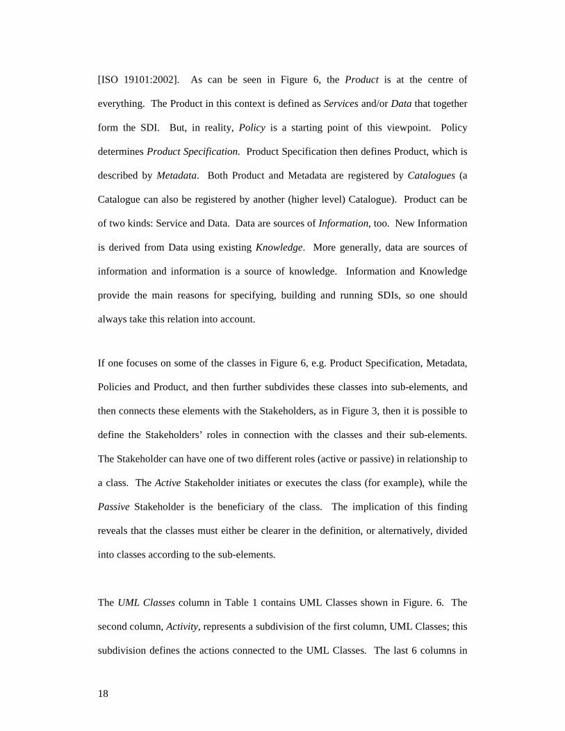
[ISO 19101:2002]. As can be seen in Figure 6, the Product is at the centre of
everything. The Product in this context is defined as Services and/or Data that together
form the SDI. But, in reality, Policy is a starting point of this viewpoint. Policy
determines Product Specification. Product Specification then defines Product, which is
described by Metadata. Both Product and Metadata are registered by Catalogues (a
Catalogue can also be registered by another (higher level) Catalogue). Product can be
of two kinds: Service and Data. Data are sources of Information, too. New Information
is derived from Data using existing Knowledge. More generally, data are sources of
information and information is a source of knowledge. Information and Knowledge
provide the main reasons for specifying, building and running SDIs, so one should
always take this relation into account.
If one focuses on some of the classes in Figure 6, e.g. Product Specification, Metadata,
Policies and Product, and then further subdivides these classes into sub-elements, and
then connects these elements with the Stakeholders, as in Figure 3, then it is possible to
define the Stakeholders’ roles in connection with the classes and their sub-elements.
The Stakeholder can have one of two different roles (active or passive) in relationship to
a class. The Active Stakeholder initiates or executes the class (for example), while the
Passive Stakeholder is the beneficiary of the class. The implication of this finding
reveals that the classes must either be clearer in the definition, or alternatively, divided
into classes according to the sub-elements.
The UML Classes column in Table 1 contains UML Classes shown in Figure. 6. The
second column, Activity, represents a subdivision of the first column, UML Classes; this
subdivision defines the actions connected to the UML Classes. The last 6 columns in

19
Table 1 represent the Stakeholders identified as the Actors in Figure 3 and defined in
section 7: Policy Maker, Producer, Provider, Broker, VAR and End User.
The role for each actor can be derived from Table 1. For example, End Users in an SDI
are active in the following activities:
• Stipulate requirements for product specifications;
• Use products;
• Search through metadata;
• Analyse metadata;
• Search for catalogues; and
• Search through catalogues.
Table 1 describes which Stakeholders are engaged in each given activity. For example,
the activity “Provide metadata” requires that the Provider, Broker and the VAR play an
active role, while the End User has a passive role. Some of the actions require further
description, e.g. “Harvest metadata”, “Search for catalogues” and “Search through
catalogue”. This is described as follows: “Harvest metadata” can be seen as an
automated process to gather, extract, index and search metadata on the internet. “Search
for catalogues” is to look somewhere (in general on the Internet) carefully to find the
relevant catalogue. “Search through catalogue” is to look in a catalogue in order to find
the relevant product.
In developing Table 1, choices were made. One is that an Actor can be only Active,
Passive or Not Applicable, for any given Activity. The purpose of this choice is to have

20
a clear overview of the relationships between Actors and the Activities. However, some
of the Actors might be both Active and Passive for a given activity. In such a case, the
Active role has been retained. For example, the VAR has a passive role in receiving the
product produced by the Producer and has an active role in adding value to this product.
The End User will be passive in the “Make policy” Activity in most SDIs. However,
there may be some SDIs where the End User may play a more active role in developing
policy (eg: as a result of user surveys). Because a Product is defined as consisting of
both Data and Services, the Producer, Provider, Broker and the VAR are considered as
active in the “Produce product” Activity.
Another activity that needs a further explanation is “Stipulate requirements”. In
addition to the User, it was agreed that the Producer and VAR should be considered as
Active contributors since they may know about the latest technological developments
and have received new requirements from the End Users.
A more detailed examination of Table 1 reveals the following findings:
• The End User appears to have passive roles for most of the activities. This
reflects that he/she is the main beneficiary of those activities within an SDI.
• There are a lot of similarities between the Producer, Provider, Broker and the
VAR. These similarities mainly result from the fact that a product may be either
data or services, e.g. a Service Provider is considered as being Active in the
Produce Product activity.
• The activity of Capture/Create Data is specific to the Producer and the VAR.

21
• The activity of “Harvest Metadata” is specific to the Broker.
9. CONCLUSION AND FUTURE DIRECTIONS
This work is a result of the activities undertaken by the ICA Commission on Spatial
Data Standards, according to its Terms of Reference for the period 2003-2007. The
Commission adopted the use of Open Distributed Processing Reference Model (RM-
ODP) as a general framework for modelling SDIs and the Unified Modeling Language
(UML) for modelling the specifics of SDIs.
The synergy of RM-ODP combined with UML results in a comprehensive set of models
used to describe a Spatial Data Infrastructure (SDI) in terms of its scope, activities and
actors. This work continued through two RM-ODP viewpoints, the Enterprise and
Information Viewpoints. In the Enterprise Viewpoint, six SDI Stakeholders were
defined with a Use Case model (Policy Maker, Producer, Provider, Broker, VAR and
End User) and a UML Class model of the SDI was developed. In the Information
Viewpoint, UML Class models of the SDI were developed, showing what is needed for
SDIs to deliver Products (both Data and Services).
A table of the six Actors and 27 defined Activities in an SDI was developed. It
indicates whether each Actor is Active, Passive or Not Involved in each of these
Activities. Interpreting this table resulted in several findings, including: the End User
appears to have passive roles for most of the activities and there are many similarities
between the Producer, Provider, Broker and the VAR.

22
This all provides more insight into the internal processes of an SDI and how they are
inter-related, from the RM-ODP Enterprise and Information Viewpoints.
9.1. Future Work
In due course, the models presented in this paper, should be further refined and
extended by the addition of the Computation Viewpoint, which comprises the services
in an SDI, consistent with the concepts exposed in the Enterprise and Information
Viewpoints. Future work is also necessary to validate the model in specific user
communities and at different levels of SDI (Local, National, Regional and Global).
10. ACKNOWLEDGEMENTS
Access and office facilities for the ICA Spatial Data Standards Commission have been
provided by the Department of Geography, Ohio State University, Columbus, Ohio,
USA. We would also like to recognise the many hosts of our Commission meetings
wherein we worked on developing formal models of SDIs: Masuryk University (Brno),
Council for Scientific and Industrial Research (Ithala), International Hydrographic
Bureau (Monaco), Instituto Geográfico Nacional (A Coruña), and the University of
Vienna (Vienna).
This research has been partially supported by our employers and by funding from a
number of sources:

23
• Project No. 1ET101940420 "Logic and Artificial Intelligence for multi-agent
systems" supported by the program "Information Society" of the Czech
Academy of Sciences.
• The South African National Research Foundation (NRF).
This is to recognize the contribution of Kevin Hawley in editing and polishing this
manuscript for the ICA Spatial Data Standards Commission. This is also to recognise
the contribution of Tomáš Řezník in the Vienna meeting.
Preliminary papers on this work were presented at the International Cartographic
Conferences in Durban, South Africa, in 2003 [Cooper et al 2003] and A Coruña,
Spain, in 2005 [Hjelmager et al 2005].

24
Annex 1
Only the UML elements utilized in this work are described in this Annex.
The UML notations used for class diagrams
Associations
An association is used to describe a relationship between two or more classes. It
mirrors the different types of relationships: association, aggregation and composition.
Association – a general relationship between two classes.
Aggregation – relationship between two classes where one class plays the role of a
container and the other plays the role of the contained entity.
Composition – a strong aggregation, used when the objects representing the parts of a
container object cannot exist without the contained object.

25
Generalization
A generalization is a relationship between a superclass and the subclasses that may
replace the superclass. The superclass is the generalized class, while the subclasses are
specified classes.

26
Roles
At each end of the association, the role, that is the context an object takes within the
association, may also be indicated. If an association is navigable in a particular
direction, the model shall supply a “role name” that is appropriate for the role of the
target object in relation to the source object. In a two-way association, two role names
will be supplied.
The UML notations used in this for Use Case diagram
Use cases
Use cases, drawn as horizontal ellipses, describe sequences of actions that provide
something of measurable value to actors.
Actors
Actors, drawn as stick figures, are persons, organizations, or external systems that play
roles in interactions with your system.
Associations
Solid lines are used in use case diagrams to indicate the associations between actors and
use cases. An association exists whenever an actor is involved in an interaction
described by a use case.

27
.

28
11. REFERENCES
Cooper AK, Hjelmager J, Nielsen A and Rapant P (2003), A Description of Spatial Data
Infrastructures (SDIs) Using the Unified Modelling Language (UML), 21st
International Cartographic Conference, Durban, South Africa.
Delgado T (March 2005), ”Infraestructures de Datos Espaciales en países de bajo
desarrollo tecnológico. Implementación en Cuba”, PhD thesis, ITM José Martr.
Federal Geographic Data Committee (December 2003), A Geospatial Interoperability
Reference Model (GIRM), Version 1.1, http://gai.fgdc.gov/girm/
Global Spatial Data Infrastructure (2004a), The SDI Cookbook, Version 2.0,
http://www.gsdi.org/docs2004/cookbook/cookbookV2.0.pdf
Global Spatial Data Infrastructure (2004b), GSDI Association home page,
http://130.11.63.121/main2.html
Groot, Richard, and John McLaughlin (Eds.) (2000), “Geospatial Data Infrastructure:
Concepts, Cases and Good Practice”, Oxford: Oxford University Press, 286pp.
Hjelmager J, Delgado T, Moellering H, Cooper AK, Danko D, Huet M, Aalders H &
Martynenko A (2005), “Developing a Modelling for the Spatial Data
Infrastructure”, 22nd International Cartographic Conference, A Coruña, Spain.

29
ICA Spatial Data Standards Commission (2003), Meetings held in Ithala, S. Africa,
August, 2003.
ICA Spatial Data Standards Commission (2004), Meetings held at IHO Headquarters,
Monaco, July, 2004.
ICA (2003), Reports of the ICA Commissions 1999-2003,
http://www.icaci.org/en/ga_reports_texts.html, accessed 6 July 2006.
Interoperability Clearinghouse (2006). http://www.ichnet.org/glossary/
ISO/IEC 10746:1995, Information technology – Open Distributed Processing –
Reference model.
ISO/IEC 19501:2005, Information technology – Open Distributed Processing – Unified
Modeling Language (UML) Version 1.4.2.
ISO 19101:2002, Geographic Information – Reference model.
ISO/PDTS 19139 (2005), Geographic Information – Metadata – XML schema
implementation.
Moellering, H. (1980), "Strategies of Real-Time Cartography", Cartographic Journal,
17(1), June, pp. 12-15.

30
Moellering, H, (1984),"Real Maps, Virtual Maps and Interactive Cartography", Chapter
in Spatial Statistics and Models, G. L. Gaile and C. J. Wilmott, editors,
Dordrecht: Reidel Publishing Co., pp. 109-131.
Moellering, H, (2000),"The Scope and Content of Analytical Cartography", in
Moellering (ed.), The Nature of Analytical Cartography, Special Issue on
Analytical Cartography, Cartography and Geographic Information Science,
27(3), pp. 205 - 223.
National Research Council (1999)., “Distributed Geolibraries: Spatial Information
Resources, Summary of a Workshop”, Washington DC: National Academy
Press, 119pp.
Nyerges, T, (1980), Modelling the Structure of Cartographic Information for Query
Processing, Unpublished Ph.D. dissertation, Ohio State University, Columbus,
Ohio. 203 pp.
Nyerges, T, (1991), "Geographic Information Abstractions: Conceptual Clarity for
Geographic Modeling", Environment and Planning A, 32, pp. 1483-1499.12
Rajabifard A, Feeney M & Williamson IP, 2003, “Spatial data infrastructures:
Concepts, natures and SDI hierarchy”, in Williamson IP, Rajabifard A & Feeney

31
M (eds), Developing spatial data infrastructures: From concept to reality, Taylor
& Francis.
Tobler WR (1979), “A transformational view of cartography”, The American
Cartographer, 6(2), pp 101-106.

32
Figure 1. The RM-ODP model highlighting the two Viewpoints described here

33
Figure 2. Use Case Diagram for the Enterprise Viewpoint
Provide servicethrough SDI
Use service fromSDI
Set policy for SDI
Determine visionand mission of SDI
Apply policy forSDI
StakeholderBuild
infrastructure
Why have an SDI in the first place?
To facilitate provision, management, sharing and use of spatial data and services (including discovery, evaluation, and application)
Based on collection of technologies, policies, institutional arrangements and interoprability to facilitate availability of, and accessibility to spatial data.
To develop a roadmap (implementation procedure, etc.) to go from vision to reality
Includes providing data and metadata
Includes searching for data, obtaining data, processing data and using data
Includes developing standards, best practices, pricing, intelectual property, custodianship and accessibility
Includes access, interoperability, partnership etc
Includes communication links, hardware and software platforms, processingtools etc

34
Figure 3. The stakeholders
Stakeholder
User
Producer Broker
Provider
Policy maker
Value Added Reseller

35
Fig
ure
4.
The
Hig
h-le
vel U
ML
Cla
sse
s of
the
Ent
erp
ris
e V
iew
poin
t of
an
SD
I
+Scope-ImplementationPlan
SDI
Policies
-Bandwidth
Connectivity
ProcessingTools
0..*
1..*SDIHasConnectivity
1..*
1..*SDIHasPolicies
1..*
1..*
SDIHasProcessingTools
Metadata
1..*
0..*
SDI Metadata
0..*1..* SDIConsistsOfProducts
ProductProcessingTools
ProduceManageUseMetadata
Product
*ConnectivityUsesTechnology
*ProcessingToolsUsesConnectivity
ServiceCreateData
ProductsHaveMetadata
«interface»Technology
Policies should support interoperability

36
Figure 5. The Various Types of Policies in an SDI and Their Relationships
Policies
StandardsConstraints BestPractices
LegalConstraints BusinessAgreements
BusinessModel

37
Figure 6. The Information Viewpoint of an SDI
Policy Metadata
Product
Catalogue
Data InformationService
1
0..*
Determines
1..*
1..*
Describes
1 0..*
Defines
0..* 0..*
Registers
0..*
0..*Registers
0..*
0..*
Registers
Knowledge
0..* 1
Product Specification

38
UML Classes Stakeholder (Actor)
Activity
Policy Maker
Producer Provider Broker VAR End User
Make policy A P P P P P
Apply policy A A A A A P
Make business plan - A A A A -
Use business plan - A A A A -
Policies
Consult users A A A - A P
Stipulate requirements P A P P A A
Translate into product specifications
- A A A A P
Obtain and implement product specifications
- A A A A P
Product specifications
Capture/create data (from source) - A - - A -
Produce product - A A A A -
Assure quality (productions process)
- A A A A -
Assure quality (certification of product)
- A A A A P
Provide product - - A A A P
Use products - - - - A A
Maintain product - A A A A -
Product
Produce metadata - A A A A -
Assure quality of metadata - A A A A -
Provide metadata - - A A A P
Harvest metadata - - P A P -
Search through metadata - - - A A A
Analyse metadata - - - A A A
Maintain metadata - A A A A -
Metadata (incl. Service capability)
Produce catalogue - A A A A - Provide catalogue - - A A A P Search for catalogue (incl. chaining)
- - - A A A
Search through catalogue - - - A A A
Catalogue
Maintain catalogue - A A A A -
A: Active-Maker; P: Passive-Receivers -: Not Applicable
Table 1: Actors and Activities in an SDI