1
UNITAR - UNOSAT - Palais des Nations CH-1211 Geneva 10, Switzerland - T: +41 22 767 4020 (UNOSAT Operations) - Hotline 24/7 : +41 75 411 4998 - [email protected] - www.unitar.org/unosat 37°20'0"E 37°20'0"E 37°18'0"E 37°18'0"E 37°16'0"E 37°16'0"E 37°14'0"E 37°14'0"E 37°12'0"E 37°12'0"E 37°10'0"E 37°10'0"E 37°8'0"E 37°8'0"E 37°6'0"E 37°6'0"E 37°4'0"E 37°4'0"E 37°2'0"E 37°2'0"E 36°16'0"N 36°16'0"N 36°14'0"N 36°14'0"N 36°12'0"N 36°12'0"N 36°10'0"N 36°10'0"N 36°8'0"N 36°8'0"N SYRIA Aleppo City / Aleppo Governorate Imagery analysis: 18 September 2016 | Published Thursday, December 15, 2016 Complex emergency CE20130604SYR This map illustrates satellite-detected damage density in the city of Aleppo, Syrian Arab Republic. Satellite imagery acquired 18 September 2016, 01 May 2015, 26 April 2015, 23 May 2014, 23 September 2013, and 21 November 2010 was analyzed. UNITAR - UNOSAT identified a total of 35,722 affected structures, of which 4,773 were destroyed, 14,680 severely damaged, and 16,269 moderately damaged, as of 18 September 2016. This represents an increase of approximately 154.5% in total damage since the previous UNITAR-UNOSAT analysis done using images from 1 May 2015 and 26 April 2015. This analysis was done as part of the REACH initiative for the U.S. Office of Foreign Disaster Assistance. It is a preliminary analysis and has not yet been validated in the field. Please send ground feedback to UNITAR - UNOSAT. ¥ ¦ ¬ ¥ ¦ ¬ ¥ ¦ ¬ ¥ ¦ ¬ SYRIA IRAQ TURKEY Beirut Damascus The depiction and use of boundaries, geographic names and related data shown here are not warranted to be error-free nor do they imply official endorsement or acceptance by the United Nations. UNOSAT is a program of the United Nations Institute for Training and Research (UNITAR), providing satellite imagery and related geographic information, research and analysis to UN humanitarian & development agencies & their implementing partners. This work by UNITAR-UNOSAT is licensed under a CC BY-NC 3.0 Damage density in the City of Aleppo, Syria Satellite Data (1): WorldView-3 Imagery Date: 18 September 2016 Resolution: 40 cm Copyright: DigitalGlobe, Inc. Source: Department of State, Humanitarian Information Unit, NextView License Satellite Data (2): Pleiades Imagery Dates: 01 May 2015 & 26 April 2015 Resolution: 50 cm Copyright: CNES (2015), Distribution AIRBUS DS Source: Airbus Defense and Space Satellite Data (3): Multiple previous images Road Data : Google Map Maker / OSM / ESRI Other Data: USGS, UNCS, NASA, NGA Analysis : UNITAR - UNOSAT Production: UNITAR - UNOSAT ! I Map Scale for A3: 1:84,000 Analysis conducted with ArcGIS v10.4.1 Coordinate System: WGS 1984 UTM Zone 37N Projection: Transverse Mercator Datum: WGS 1984 Units: Meter Æ I Map location Legend 0 1 2 3 4 0.5 Km See inset for close-up view of damaged & destroyed structures INSET: 23 May 2014 INSET: 18 September 2016 Secondary road Damage Site Density Index High Low Primary road Urban road

Aleppo City / Aleppo Governorate - UNITAR · 9/18/2016  · Aleppo City / Aleppo Governorate Imagery analysis: 18 September 2016 | Published Thursday, December 15, 2016 Complex emergency

  • Upload
    others

  • View
    16

  • Download
    0

Embed Size (px)

Citation preview

UNITAR - UNOSAT - Palais des Nations CH-1211 Geneva 10, Switzerland - T: +41 22 767 4020 (UNOSAT Operations) - Hotline 24/7 : +41 75 411 4998 - [email protected] - www.unitar.org/unosat

37°20'0"E

37°20'0"E

37°18'0"E

37°18'0"E

37°16'0"E

37°16'0"E

37°14'0"E

37°14'0"E

37°12'0"E

37°12'0"E

37°10'0"E

37°10'0"E

37°8'0"E

37°8'0"E

37°6'0"E

37°6'0"E

37°4'0"E

37°4'0"E

37°2'0"E

37°2'0"E

36°1

6'0"N

36°1

6'0"N

36°1

4'0"N

36°1

4'0"N

36°1

2'0"N

36°1

2'0"N

36°1

0'0"N

36°1

0'0"N

36°8

'0"N

36°8

'0"N

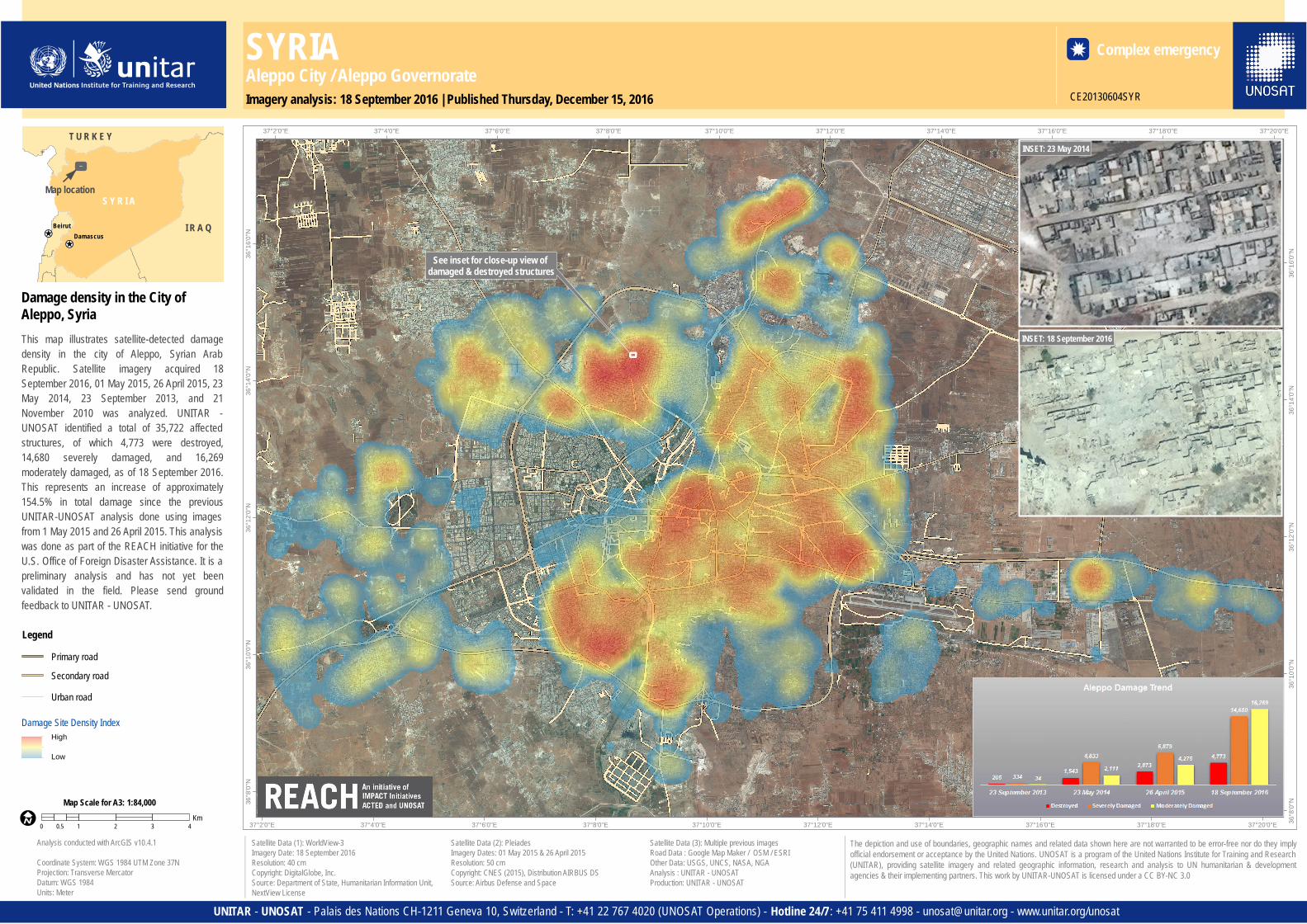
SYRIAAleppo City / Aleppo GovernorateImagery analysis: 18 September 2016 | Published Thursday, December 15, 2016

Complex emergency

CE20130604SYR

This map illustrates satellite-detected damagedensity in the city of Aleppo, Syrian ArabRepublic. Satellite imagery acquired 18September 2016, 01 May 2015, 26 April 2015, 23May 2014, 23 September 2013, and 21November 2010 was analyzed. UNITAR -UNOSAT identified a total of 35,722 affectedstructures, of which 4,773 were destroyed,14,680 severely damaged, and 16,269moderately damaged, as of 18 September 2016.This represents an increase of approximately154.5% in total damage since the previousUNITAR-UNOSAT analysis done using imagesfrom 1 May 2015 and 26 April 2015. This analysiswas done as part of the REACH initiative for theU.S. Office of Foreign Disaster Assistance. It is apreliminary analysis and has not yet beenvalidated in the field. Please send groundfeedback to UNITAR - UNOSAT.

¥¦¬¥¦¬

¥¦¬ ¥¦¬

S Y R I A

I R A Q

T U R K E Y

BeirutDamascus

The depiction and use of boundaries, geographic names and related data shown here are not warranted to be error-free nor do they implyofficial endorsement or acceptance by the United Nations. UNOSAT is a program of the United Nations Institute for Training and Research(UNITAR), providing satellite imagery and related geographic information, research and analysis to UN humanitarian & developmentagencies & their implementing partners. This work by UNITAR-UNOSAT is licensed under a CC BY-NC 3.0

Damage density in the City ofAleppo, Syria

Satellite Data (1): WorldView-3Imagery Date: 18 September 2016Resolution: 40 cmCopyright: DigitalGlobe, Inc.Source: Department of State, Humanitarian Information Unit,NextView License

Satellite Data (2): PleiadesImagery Dates: 01 May 2015 & 26 April 2015Resolution: 50 cmCopyright: CNES (2015), Distribution AIRBUS DSSource: Airbus Defense and Space

Satellite Data (3): Multiple previous imagesRoad Data : Google Map Maker / OSM / ESRIOther Data: USGS, UNCS, NASA, NGAAnalysis : UNITAR - UNOSATProduction: UNITAR - UNOSAT

!IMap Scale for A3: 1:84,000

Analysis conducted with ArcGIS v10.4.1

Coordinate System: WGS 1984 UTM Zone 37NProjection: Transverse MercatorDatum: WGS 1984Units: Meter

ÆI

Map location

Legend

0 1 2 3 40.5Km

See inset for close-up view of damaged & destroyed structures

INSET: 23 May 2014

INSET: 18 September 2016

Secondary road

Damage Site Density IndexHigh

Low

Primary road

Urban road