Embed Size (px)
Citation preview
PERMIT APPLICATION SUPPLEMENT
ALAMITOS BAY MARINA REHABILITATION
Prepared for City of Long Beach
Department of Parks, Recreation, and Marine
205 Marina Drive
Long Beach, California 90815
Prepared by Anchor QEA, L.P.
28202 Cabot Road, Suite 425
Laguna Niguel, California 92677
November 2009
TABLE OF CONTENTS
Permit Application Supplement November 2009 Alamitos Bay Marina Rehabilitation i 080482-01
1 INTRODUCTION – PURPOSE AND NATURE OF THE ACTIVITY ................................. 1 1.1 Purpose and Need Statement ...........................................................................................3
2 DETAILED DESCRIPTION OF THE ACTIVITIES REQUIRING A DEPARTMENT OF THE ARMY PERMIT ............................................................................................................ 4
2.1 Dock and Piling Replacement .........................................................................................4 2.2 Dredging and Disposal of Dredged Material ...................................................................5 2.3 Restroom Upgrades ..........................................................................................................6 2.4 Seawall Repairs .................................................................................................................6 2.5 Temporary Dock/Long Dock ...........................................................................................7 2.6 Parking Lot Replacement ................................................................................................7 2.7 Water Open Space/Habitat Mitigation Site ....................................................................7
3 PROJECT TIMING AND CONSTRUCTION METHODS .................................................... 9
4 PERMITS REQUESTED ...................................................................................................... 10
5 ESSENTIAL FISH HABITAT ............................................................................................... 11 5.1 Anticipated Project Impacts to Essential Fish Habitat .................................................13
5.1.1 Specific Impacts to Eelgrass .....................................................................................15 5.1.2 Avoidance, Minimization, and Mitigation of Project Impacts to Essential Fish
Habitat ......................................................................................................................16
6 ENDANGERED SPECIES ACT AND MARINE MAMMAL PROTECTION ACT ............ 18
7 BEST MANAGEMENT PRACTICES AND MITIGATION MEASURES ........................... 20
8 REFERENCES ...................................................................................................................... 22
TABLE OF CONTENTS
Permit Application Supplement November 2009 Alamitos Bay Marina Rehabilitation ii 080482-01
List of Tables Table 1 Existing and Proposed Slip Mix at Alamitos Bay Marina ................................. 5 Table 2 Alamitos Bay Rehabilitation Project Phases ..................................................... 9 Table 3 Summary of Permit Requested ........................................................................ 10 Table 4a Species with the Potential to Occur Within or Nearby the Project Area and
Managed Under the Coastal Pelagic FMP ....................................................... 12 Table 4b Species with the Potential to Occur Within or Nearby the Project Area and
Managed Under the Pacific Groundfish FMP ................................................. 12 Table 5 Project Impacts to Eelgrass by Basin ................................................................ 15
List of Photographs Photograph 1 Example of Broken Pile Bracket at Alamitos Bay Marina ................................ 1 Photograph 2 Example of Dock Conditions at Alamitos Bay Marina ..................................... 2
List of Figures Figure 1 Overview of Work at Alamitos Bay Marina Figure 2 Basin 1 Figure 3 Basin 2 Figure 4 Basin 3 Figure 5 Basin 4 Figure 6 Basin 5 Figure 7 Basin 6N
Figure 8 Basin 6S Figure 9 Basin 7 Figure 10 Marine Stadium – Eelgrass Mitigation Site
List of Attachments Attachment A Sediment Disposal Plan Approval Attachment B Marine Stadium Eelgrass Mitigation Site Assessment – Tidal Hydraulic
Analysis
LIST OF ACRONYMS AND ABBREVIATIONS
Permit Application Supplement November 2009 Alamitos Bay Marina Rehabilitation iii 080482-01
ABM Alamitos Bay Marina ADA Americans with Disabilities Act Basin 6N Basin 6-North Basin 6S Basin 6-South BMP best management practice CAD confined aquatic disposal CCC California Coastal Commission CDF confined disposal facility CDFG California Department of Fish and Game CDP Coastal Development Permit City City of Long Beach CRM Coastal Resources Management CWA Clean Water Act cy cubic yard DBAW Department of Boating and Waterways EFH Essential Fish Habitat EIR Environmental Impact Report ESA Endangered Species Act FCD Federal Consistency Determination FMP Fisheries Management Plan HAPC Habitat Areas of Particular Concern MLLW mean lower low water MSA Magnuson-Stevens Fishery Conservation and Management Act NMFS National Marine Fisheries Service RWQCB Regional Water Quality Control Board SCEMP Southern California Eelgrass Mitigation Policy sf square foot SIP Standard Individual Permit USACE U.S. Army Corps of Engineers USEPA U.S. Environmental Protection Agency
Introduction – Purpose and Nature of the Activity
Permit Application Supplement November 2009 Alamitos Bay Marina Rehabilitation 1 080482-01
1 INTRODUCTION – PURPOSE AND NATURE OF THE ACTIVITY
The Alamitos Bay Marina (ABM) comprises several marina basins within Alamitos Bay, located within the City of Long Beach, California (Figure 1). Alamitos Bay contains 7 miles of inland waterways for recreational water-related uses. ABM, comprised of eight basins located throughout Alamitos Bay, opened in the late 1950s, and marina facilities are currently operated by the City of Long Beach (City) Marine Bureau. Because the ABM opened nearly 60 years ago, the marina is in a deteriorated condition (Photographs 1 and 2) and in need of upgrades to make the marina consistent with current market demands. Examples of needed repairs include spalled piles, broken pile brackets, broken utilities, unsafe deck surfaces, and shoaling. The Alamitos Bay Marina rehabilitation project will replace the existing marina and upgrade several aspects of the marina. The proposed project includes renovations to Basins 1 through 7, which will exclude Basin 8. Locations of all basins are shown on Figure 1. Basin 6 is comprised of two separate areas: Basin 6-North (6N) and Basin 6-South (6S). Each of the seven basins has a different number of slips (ranging in size from 20 to 120 feet in length) available to boaters. No boaters will be displaced during project construction activities. Boaters will be temporarily relocated to other basins within Alamitos Bay until their basin is complete, and all current tenants are guaranteed a slip upon completion of the project. The marina project is proposed to take place in 12 phases that will span 6 years.
Photograph 1. Example of Broken Pile Bracket at Alamitos Bay Marina.
Introduction – Purpose and Nature of the Activity
Permit Application Supplement November 2009 Alamitos Bay Marina Rehabilitation 2 080482-01
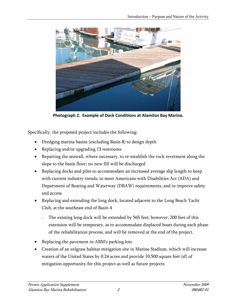
Photograph 2. Example of Dock Conditions at Alamitos Bay Marina.
Specifically, the proposed project includes the following:
• Dredging marina basins (excluding Basin 8) to design depth • Replacing and/or upgrading 13 restrooms • Repairing the seawall, where necessary, to re-establish the rock revetment along the
slope to the basin floor; no new fill will be discharged • Replacing docks and piles to accommodate an increased average slip length to keep
with current industry trends, to meet Americans with Disabilities Act (ADA) and Department of Boating and Waterway (DBAW) requirements, and to improve safety and access
• Replacing and extending the long dock, located adjacent to the Long Beach Yacht Club, at the southeast end of Basin 4
− The existing long dock will be extended by 565 feet; however, 200 feet of this extension will be temporary, as to accommodate displaced boats during each phase of the rehabilitation process, and will be removed at the end of the project.
• Replacing the pavement in ABM’s parking lots • Creation of an eelgrass habitat mitigation site in Marine Stadium, which will increase
waters of the United States by 0.24 acres and provide 10,500 square feet (sf) of mitigation opportunity for this project as well as future projects
Introduction – Purpose and Nature of the Activity
Permit Application Supplement November 2009 Alamitos Bay Marina Rehabilitation 3 080482-01
1.1 Purpose and Need Statement
The basic project purpose is the fundamental and irreducible purpose of the proposed project. For purposes of the U.S. Army Corps of Engineers (USACE) Clean Water Act (CWA) Section 404(b)(1) evaluation, this purpose determines water dependency. The basic project purpose for this project is recreational boating, which is water dependent. The CWA overall project purpose describes the essential goals of the project without constraining the analysis of a reasonable range of alternatives. This project purpose statement is the backbone of the 404(b)(1) analysis. The overall project purpose of the proposed project is to upgrade the ABM by repairing and replacing aged infrastructure, including maintenance dredging to remove shoaled materials that pose a hazard to navigation. The project meets a public need for safe recreational boating opportunities.
Detailed Description of the Activities Requiring a Department of the Army Permit
Permit Application Supplement November 2009 Alamitos Bay Marina Rehabilitation 4 080482-01
2 DETAILED DESCRIPTION OF THE ACTIVITIES REQUIRING A DEPARTMENT OF
THE ARMY PERMIT
2.1 Dock and Piling Replacement
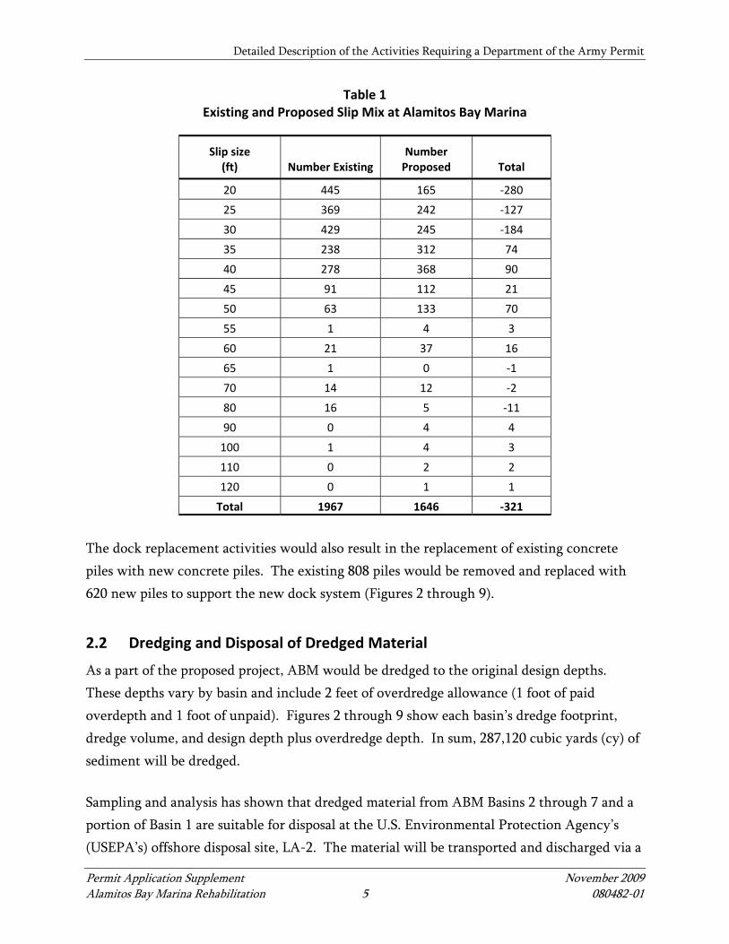
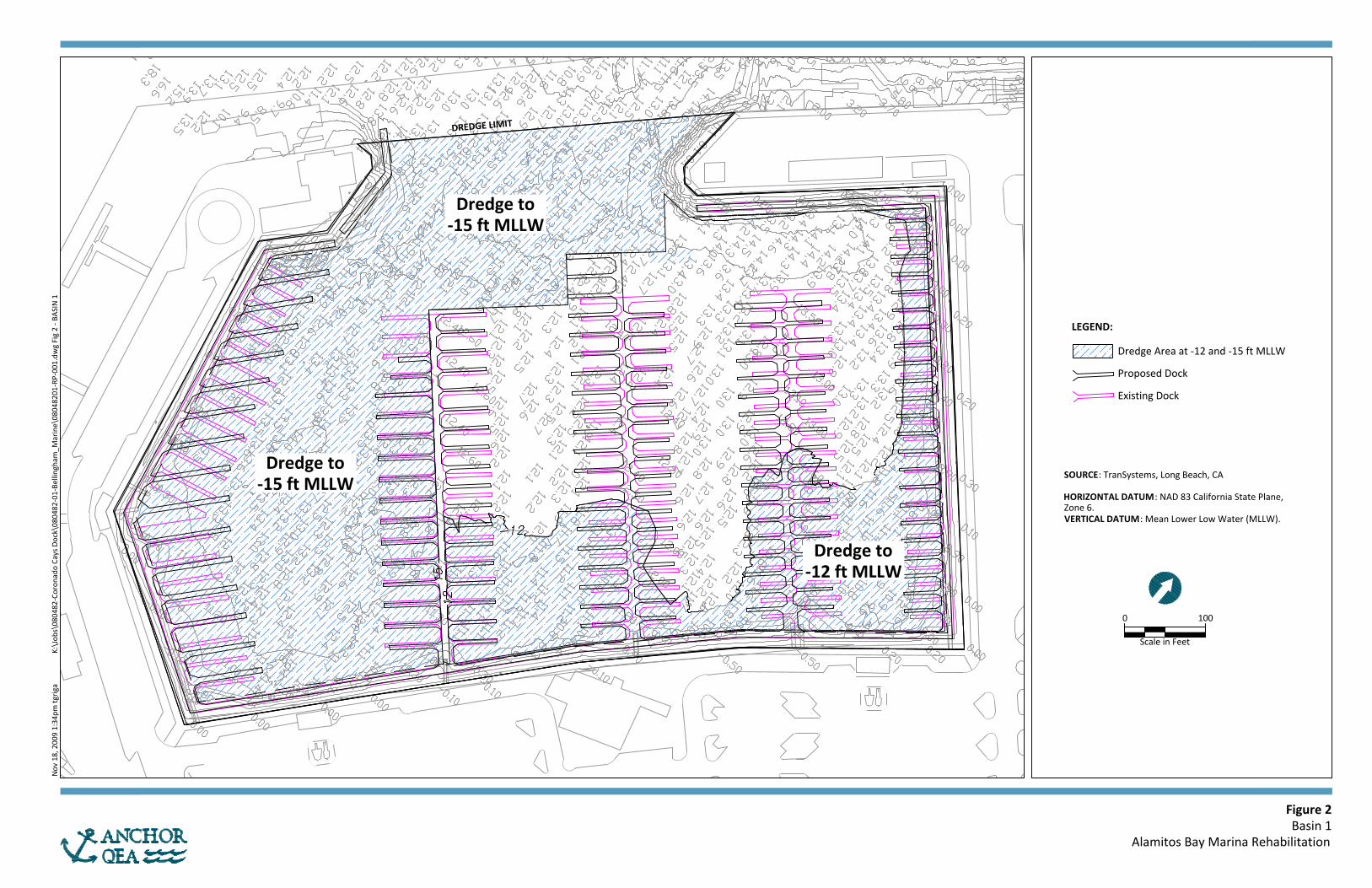
Currently, there are 1,967 existing slips in Basins 1 through 7 that account for approximately 476,839 sf of overwater coverage (Figures 2 through 9). The proposed project includes the removal and replacement of the existing docks with 1,646 slips that total approximately 474,239 sf of overwater coverage (Figures 2 through 9). The proposed project would result in a reduction in the number of slips (by 321 slips) and a reduction in overwater coverage of 2,600 sf. The change in slip mix within each basin is summarized in Table 1. Overall, 40 percent of the slips will be less than 35 feet in length. While there is a loss of total slips under 35 feet (and thus an increase in average slip size), which is necessary to match the continuing trend in the boating industry of larger boat sizes, the proposed percent of boats under 35 feet is well above current California Coastal Commission (CCC) standards of at least 25 percent of slips under 35 feet. The new docks, accessory gangways, and ramps would meet ADA and DBAW requirements. Upgraded water, electricity, and phone utilities would also be provided to the new slip facilities.
Detailed Description of the Activities Requiring a Department of the Army Permit
Permit Application Supplement November 2009 Alamitos Bay Marina Rehabilitation 5 080482-01
Table 1 Existing and Proposed Slip Mix at Alamitos Bay Marina
Slip size (ft) Number Existing
Number Proposed Total
20 445 165 ‐280
25 369 242 ‐127
30 429 245 ‐184
35 238 312 74
40 278 368 90
45 91 112 21
50 63 133 70
55 1 4 3
60 21 37 16
65 1 0 ‐1
70 14 12 ‐2
80 16 5 ‐11
90 0 4 4
100 1 4 3
110 0 2 2
120 0 1 1
Total 1967 1646 ‐321
The dock replacement activities would also result in the replacement of existing concrete piles with new concrete piles. The existing 808 piles would be removed and replaced with 620 new piles to support the new dock system (Figures 2 through 9).
2.2 Dredging and Disposal of Dredged Material
As a part of the proposed project, ABM would be dredged to the original design depths. These depths vary by basin and include 2 feet of overdredge allowance (1 foot of paid overdepth and 1 foot of unpaid). Figures 2 through 9 show each basin’s dredge footprint, dredge volume, and design depth plus overdredge depth. In sum, 287,120 cubic yards (cy) of sediment will be dredged. Sampling and analysis has shown that dredged material from ABM Basins 2 through 7 and a portion of Basin 1 are suitable for disposal at the U.S. Environmental Protection Agency’s (USEPA’s) offshore disposal site, LA-2. The material will be transported and discharged via a
Detailed Description of the Activities Requiring a Department of the Army Permit
Permit Application Supplement November 2009 Alamitos Bay Marina Rehabilitation 6 080482-01
bottom-dump barge. Due to elevated levels of mercury in some soil samples discovered during sampling in Basin 1, 25,504 cy of material from Basin 1 will be handled off site at either an approved landfill, confined aquatic disposal (CAD) site, or an upland confined disposal facility (CDF), such as a port fill. Because the material placement location is still being determined, the applicant has assumed that the materials will be trucked to Kettleman Hills Hazardous Waste Facility, a commercial chemical waste site located in Kings County, California. The applicant is in discussions with the Port of Long Beach to place the unsuitable material at the future Middle Harbor CDF, which would be the preferred option. If it is to be trucked off site, the material will be dried on a barge or at a construction staging location. This disposal plan has been approved by the USACE, USEPA, and Los Angeles Regional Water Quality Control Board (RWQCB; Attachment A).
2.3 Restroom Upgrades
There are a total of 13 restrooms located throughout the ABM basins, which are included as part of this project. Three restroom structures, located in Basin 6S, 6N, and 7, respectively, would be remodeled and renovated in place. The remaining ten restroom buildings would be demolished and replaced with similar structures that contain toilet, shower, and laundry facilities. Six of the ten structures to be demolished would be relocated to accommodate for the ADA ramps and gangways; however, each basin would continue to have the same number of restroom buildings that currently exist in the same approximate locations. This part of the project includes replacement of the existing water and sewer lines from all restrooms to the existing main lines. This part of the project does not involve any work in waters or discharges of fill.
2.4 Seawall Repairs
It is anticipated that 8,250 linear feet of seawall repair would be required as part of the proposed project. The repairs are primarily focused on restoring the eroded surface and reestablishing the rock revetment along the slope of the basin floor. Seawall repairs would be done in phases that correspond with each basin’s dock and pile replacement work. The work involves replacing existing rock; no new discharge of fill is included; and the toe of the slopes will not extend.
Detailed Description of the Activities Requiring a Department of the Army Permit
Permit Application Supplement November 2009 Alamitos Bay Marina Rehabilitation 7 080482-01
2.5 Temporary Dock/Long Dock
The project includes replacement and extension of the long dock located adjacent to the Long Beach Yacht Club, at the southeast end of Basin 4. The new 10-foot-wide long dock will be extended by approximately 565 feet from where it currently ends; however, approximately 200 feet of this long dock is temporary and is intended to accommodate displaced boats during each phase of the rehabilitation process. The 200-foot temporary portion of the dock will be removed upon project completion. It is anticipated that the temporary dock section could be relocated as a permanent dock at the completion of the ABM rehabilitation. No additional gangway is planned for the temporary dock/long dock; access to this dock would continue to be made from existing gangways located at the southeast end of Basin 4. Dock design and access would comply with ADA requirements. Approximately 3,150 sf of water area would be permanently covered by the extension of the long dock, with an additional 2,000 sf of water area covered temporarily during construction. This square footage is accounted for in Section 2.1 in calculations of overwater coverage.
2.6 Parking Lot Replacement
The project includes the replacement of the paved parking lot surfaces adjacent to the Marina slips in Basins 1, 2, 3, 4, 6N, and 6S. New asphalt paving would be installed, and the parking lots would be restriped (repaving areas total 930,622 sf). No landscaped islands within the parking lot areas would be removed. In addition, new utility connections including electricity, water, wastewater, and storm drain facilities would be installed in conjunction with the repaving of the parking areas. Concrete ramps meeting ADA requirements and concrete sidewalks and curbs are also included in the parking lot or landside improvement portion of the project. This part of the project does not involve any work in waters or discharge of fill.
2.7 Water Open Space/Habitat Mitigation Site
The City has identified a site adjacent to the northeast shore of Marine Stadium to convert to an underwater open-space/habitat mitigation site. The habitat mitigation site is located within a City-owned storage area. The proposed site is a fenced storage area that is currently used, in part, to store impounded items. The proposed site has been modeled in 2009 to
Detailed Description of the Activities Requiring a Department of the Army Permit
Permit Application Supplement November 2009 Alamitos Bay Marina Rehabilitation 8 080482-01
determine whether sufficient conditions exist to support eelgrass. The Marine Stadium Eelgrass Mitigation Site Assessment – Tidal Hydraulic Analysis is included as Attachment B. The project includes abandoning a portion of the storage yard to create an open-space habitat through excavation of the soil to create new waters. In sum, an area of 219 feet by 70 feet will be converted to an eelgrass mitigation site. Taking into account the riprap slope that will contain the mitigation site, the total area available for eelgrass planting will be 10,500 sq ft. The elevation of this site will be 2 to 3 feet below mean lower low water (MLLW). The existing rock revetment along Marine Stadium would be relocated to the eastern boundary of the site to allow the area to fill with water from the adjacent channel. The new underwater open-space area would be planted with eelgrass to mitigate for the project’s potential impacts to this marine resource as well as provide opportunity for future mitigation needs. This aspect of the project is discussed in more detail in Section 5. Construction of the mitigation site will increase waters of the United States by 0.24 acres and provide 10,500 sf of mitigation opportunity for this project as well as future projects.
Project Timing and Construction Methods
Permit Application Supplement November 2009 Alamitos Bay Marina Rehabilitation 9 080482-01
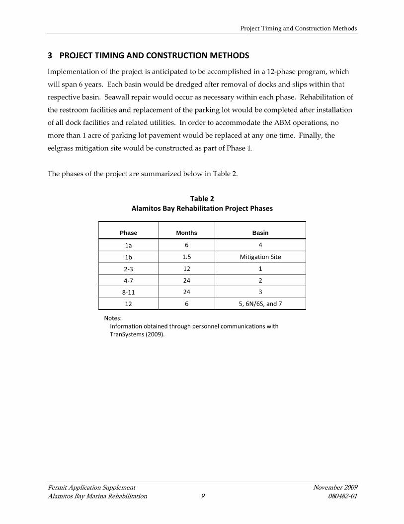
3 PROJECT TIMING AND CONSTRUCTION METHODS
Implementation of the project is anticipated to be accomplished in a 12‐phase program, which
will span 6 years. Each basin would be dredged after removal of docks and slips within that
respective basin. Seawall repair would occur as necessary within each phase. Rehabilitation of
the restroom facilities and replacement of the parking lot would be completed after installation
of all dock facilities and related utilities. In order to accommodate the ABM operations, no
more than 1 acre of parking lot pavement would be replaced at any one time. Finally, the
eelgrass mitigation site would be constructed as part of Phase 1.
The phases of the project are summarized below in Table 2.
Table 2
Alamitos Bay Rehabilitation Project Phases
Phase Months Basin
1a 6 4
1b 1.5 Mitigation Site
2‐3 12 1
4‐7 24 2
8‐11 24 3
12 6 5, 6N/6S, and 7
Notes: Information obtained through personnel communications with TranSystems (2009).
Permits Requested
Permit Application Supplement November 2009 Alamitos Bay Marina Rehabilitation 10 080482-01
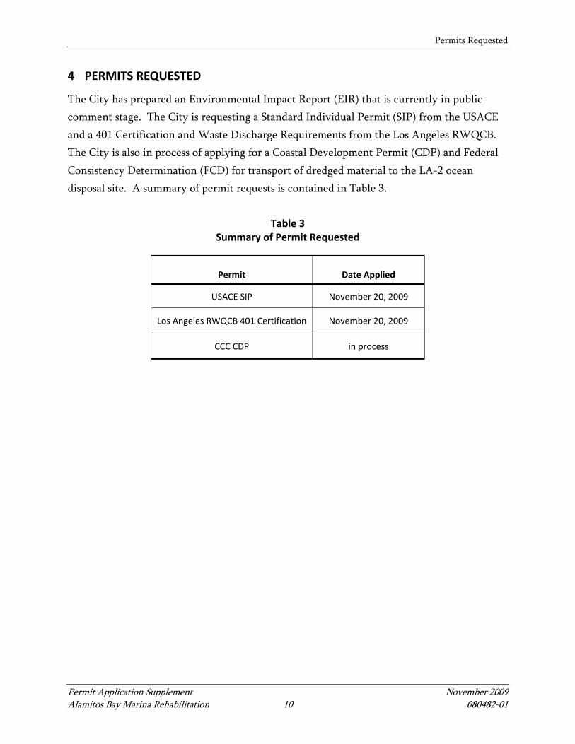
4 PERMITS REQUESTED
The City has prepared an Environmental Impact Report (EIR) that is currently in public comment stage. The City is requesting a Standard Individual Permit (SIP) from the USACE and a 401 Certification and Waste Discharge Requirements from the Los Angeles RWQCB. The City is also in process of applying for a Coastal Development Permit (CDP) and Federal Consistency Determination (FCD) for transport of dredged material to the LA-2 ocean disposal site. A summary of permit requests is contained in Table 3.
Table 3 Summary of Permit Requested
Permit Date Applied
USACE SIP November 20, 2009
Los Angeles RWQCB 401 Certification November 20, 2009
CCC CDP in process

Essential Fish Habitat
Permit Application Supplement November 2009 Alamitos Bay Marina Rehabilitation 11 080482-01
5 ESSENTIAL FISH HABITAT
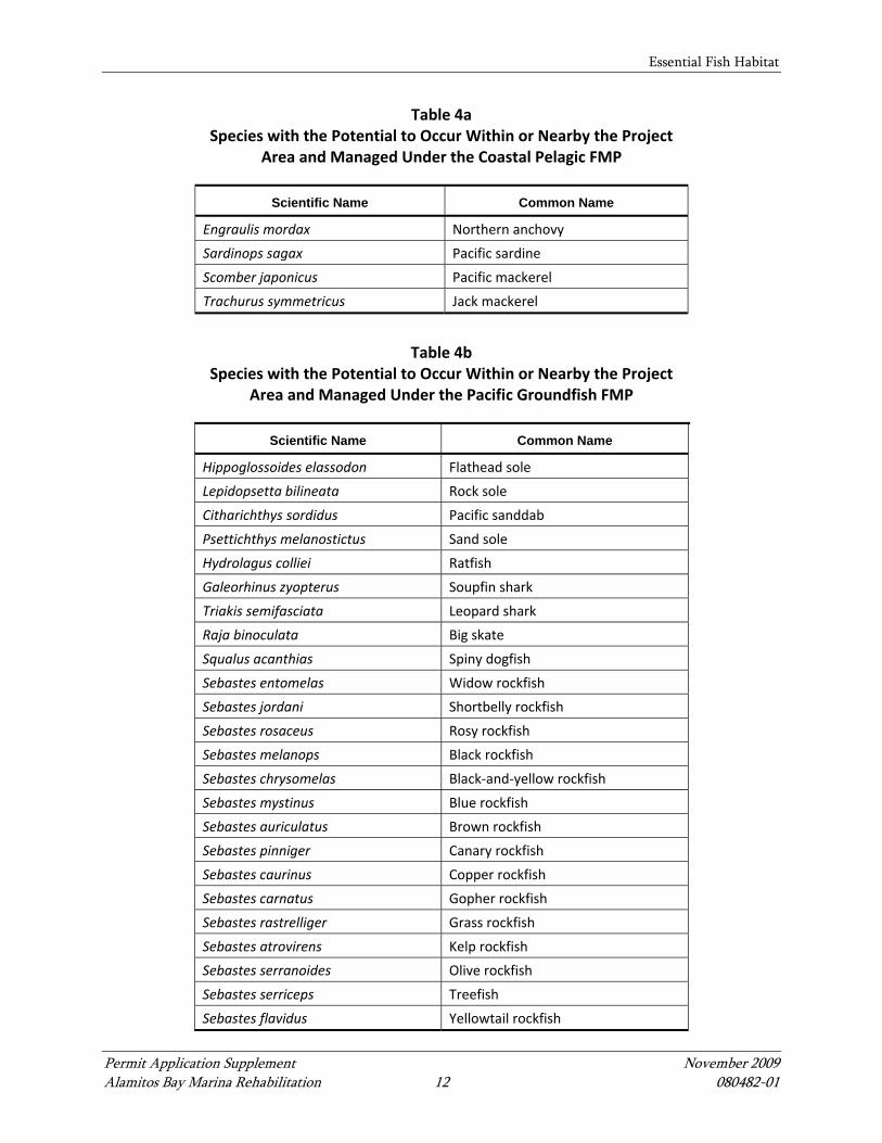
The Magnuson-Stevens Fishery Conservation and Management Act (MSA), as amended in 1996, requires the National Marine Fisheries Service (NMFS) to identify, conserve, and enhance Essential Fish Habitat (EFH) for species designated under a federal Fisheries Management Plan (FMP). The 1996 amendments to the MSA set forth a number of new mandates for NFMS, eight regional fishery management councils, and other federal agencies to identify and protect important marine and anadromous fish habitat. The councils, with assistance from NMFS, are required to delineate EFH for all managed species. EFH is defined as the waters and substrate necessary to fish for spawning, breeding, feeding, or growth to maturity. Specifically, the MSA requires: 1) federal agencies to consult with NMFS on all actions or proposed actions authorized, funded, or undertaken by the agency that could adversely affect EFH; 2) NMFS to provide conservation recommendations for any federal or state action that could adversely affect EFH; and 3) federal agencies to provide a detailed response in writing to NMFS within 30 days of receiving EFH conservation recommendations. The proposed project is located within a general area designated as EFH by two FMPs: the Coastal Pelagic Species and the Pacific Coast Groundfish FMPs. Species managed under the Highly Migratory Species FMP may have EFH within the project area, but EFH has not been designated for these species under the MSA. In addition, because these are highly mobile species, they are likely to be transient rather than stationary at the project site. Salmonids have designated EFH within another FMP, but it is highly unlikely salmonids would occur in the project area and, therefore, will not be considered. Several species under these FMPs have the potential to occur in the project area (Table 4); however, because of lack of suitable habitat few of these species have been sighted during dive surveys. The northern anchovy (Engraulis mordax), a Coastal Pelagic Species, is a common catch in otter trawls in San Pedro Bay and is likely to be abundant in the project area (CRM 2007). In addition, two Pacific Coast Groundfish species have been reported in Alamitos Bay—the leopard shark (Triakis semifasciata) and species from the rockfish genus (Sebastes spp.)—each with low abundance (CRM 2007).
Essential Fish Habitat
Permit Application Supplement November 2009 Alamitos Bay Marina Rehabilitation 12 080482-01
Table 4a Species with the Potential to Occur Within or Nearby the Project
Area and Managed Under the Coastal Pelagic FMP
Scientific Name Common Name
Engraulis mordax Northern anchovy
Sardinops sagax Pacific sardine
Scomber japonicus Pacific mackerel
Trachurus symmetricus Jack mackerel
Table 4b
Species with the Potential to Occur Within or Nearby the Project Area and Managed Under the Pacific Groundfish FMP
Scientific Name Common Name
Hippoglossoides elassodon Flathead sole
Lepidopsetta bilineata Rock sole
Citharichthys sordidus Pacific sanddab
Psettichthys melanostictus Sand sole
Hydrolagus colliei Ratfish
Galeorhinus zyopterus Soupfin shark
Triakis semifasciata Leopard shark
Raja binoculata Big skate
Squalus acanthias Spiny dogfish
Sebastes entomelas Widow rockfish
Sebastes jordani Shortbelly rockfish
Sebastes rosaceus Rosy rockfish
Sebastes melanops Black rockfish
Sebastes chrysomelas Black‐and‐yellow rockfish
Sebastes mystinus Blue rockfish
Sebastes auriculatus Brown rockfish
Sebastes pinniger Canary rockfish
Sebastes caurinus Copper rockfish
Sebastes carnatus Gopher rockfish
Sebastes rastrelliger Grass rockfish
Sebastes atrovirens Kelp rockfish
Sebastes serranoides Olive rockfish
Sebastes serriceps Treefish
Sebastes flavidus Yellowtail rockfish

Essential Fish Habitat
Permit Application Supplement November 2009 Alamitos Bay Marina Rehabilitation 13 080482-01
Table 4b Species with the Potential to Occur Within or Nearby the Project
Area and Managed Under the Pacific Groundfish FMP
Scientific Name Common Name
Scorpaena guttata California scorpionfish
Scorpaenicthys marmoratus Cabezon
Sebastes pinniger Canary rockfish
Sebastes goodie Chilipepper
Sebastes miniatus Vermilion rockfish
Gadus macrocephalus Pacific cod
Sebastes flavidus Yellowtail rockfish
Ophiodon elongates Lingcod
Anoplopoma fimbria Sablefish
Merluccius productus Pacific whiting
EFH considered to be particularly important to the long-term productivity of populations of one or more managed species, or to be particularly vulnerable to degradation, may also be identified by NMFS as Habitat Areas of Particular Concern (HAPC). For types or areas of EFH to be considered HAPC, one of the following must be demonstrated:
• Importance of the ecological function provided by the habitat • Extent to which the habitat is sensitive to human-induced environmental degradation • Whether, and to what extent, development activities are, or will be, negatively
impacting the habitat type • Rarity of the habitat
HAPCs may include high-value intertidal and estuarine habitats, offshore areas of high habitat value or vertical relief, and habitats used for migration, spawning, and rearing of fish and shellfish. The project area contains eelgrass habitat that is considered a HAPC.
5.1 Anticipated Project Impacts to Essential Fish Habitat
Overall, the project will have adverse impacts to EFH due to: 1) short-term impacts related to turbidity generated during dredging and pile removal and replacement; 2) short-term impacts due to removal of invertebrates during dredging activities; and 3) long-term impacts as a result of the removal of eelgrass in the project area during dredging, which will be mitigated. The project will also result in several benefits to EFH, including an overall
Essential Fish Habitat
Permit Application Supplement November 2009 Alamitos Bay Marina Rehabilitation 14 080482-01
reduction in shading, replacement of treated wood decks with concrete decks, and removal of contaminants in Basin 1. Because of dredging activities, pile removal, and replacement activities, there will be short-term, localized increases in turbidity. Increases in turbidity may cause clogging of gills and feeding apparatuses of fish and filter feeders. Chambers (2001) suggests that southern California harbor dredging projects would probably not generate turbidity levels at 100 meters or more from the dredge that would have a significant effect on marine organisms. In addition, a silt curtain will be in place for project dredging and jet driving of piles (should any occur) in order to further reduce spread of turbidity because of dredging activities. Therefore, impacts related to turbidity are expected to be short-term and minor. Other short-term impacts as a result of dredging include direct impacts to benthic organisms, such as abrasion, entrainment, or mortality from the clamshell bucket; however, these impacts are expected to be short-term because invertebrates are expected to recolonize dredge sites quickly. Long-term impacts from the project are expected to result from the removal of eelgrass during dredging. Removal of eelgrass will occur in three of the seven basins during dredging. Impacts to eelgrass have been avoided and minimized to the maximum extent practicable, there will be no increases in shading over eelgrass habitat, and removal is limited to areas of required maintenance dredging. However, eelgrass impacts are unavoidable due to the dredging needed to restore the ABM to design depth. Without dredging, the marina will remain shoaled and posed a continued navigation hazard. Specific impacts and mitigation as a result of removal of eelgrass in the project area are described below in Sections 5.1.1 and 5.1.2. Mitigation will compensate for all losses in productivity and eelgrass. The project does benefit EFH by reducing overwater coverage, eliminating treated wood decks, and improving circulation and water quality through dredging of shoaled material. Overwater coverage will be reduced by approximately 2,600 sf. In addition, enhancement of EFH in Basin 1 will occur as a result of this project by removal of sediments contaminated with mercury.

Essential Fish Habitat
Permit Application Supplement November 2009 Alamitos Bay Marina Rehabilitation 15 080482-01
5.1.1 Specific Impacts to Eelgrass
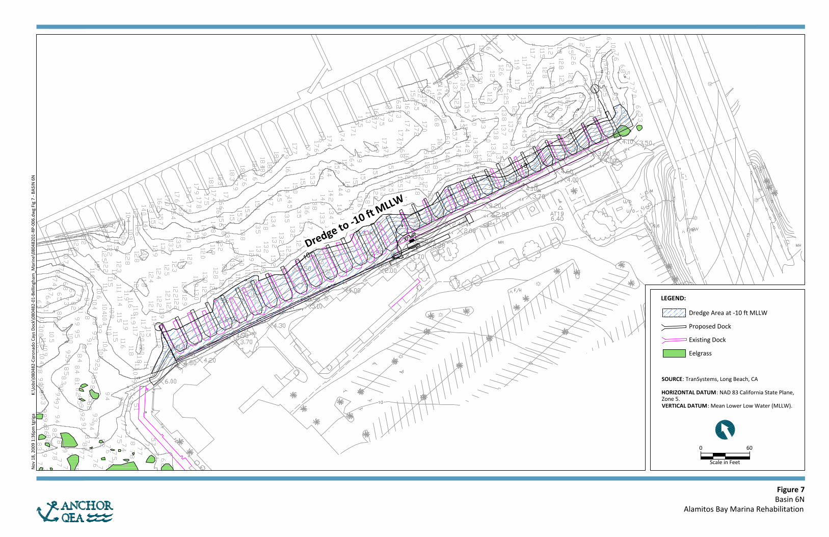
Based on two surveys conducted by CRM in October of 2007 and 2008, eelgrass will be removed through dredging where it is present in the dredge footprint of Basins 1, 4, and 6N. Eelgrass locations in relation to dock replacement activities and the dredge footprints in each basin are shown in Figures 3, 5, and 8. Table 5 below shows the amount of eelgrass per basin expected to be impacted. In sum, approximately 1,373.4 sf of eelgrass is expected to be removed during project activities, based on current surveys. The final amount of eelgrass impacted will be determined given the results of pre-construction, post-construction, and control site surveys. Mitigation for losses of eelgrass will occur at Marine Stadium (Figure 10).
Table 5 Project Impacts to Eelgrass by Basin
Location Existing Eelgrass
Vegetation
Amount of Eelgrass Within Dredging
Footprint
Mitigation Requirement: Eelgrass Vegetation
1.2 to 1
Basin 1 0.0 0.0 None
Basin 2 1,019.8 1,019.8 1,223.7
Basin 3 0.0 0.0 None
Basin 4 123.6 123.6 148.3
Basin 5 0.0 0.0 None
Basin 6‐S 23,457.0 0.0 None
Basin 6‐N 230.0 230.0 399.6
Basin 7 0.0 0.0 None
Total (sf) 24,830.4 1,373.4 1,878.1
Total (acres) 0.57 0.03 0.04
Notes: Information taken from Eelgrass (Zostera marina) Field Survey, Impact Assessment, and Mitigation Plan for the Alamitos Bay Marina Renovation Project (CRM 2007) and Analysis of Potential Eelgrass Habitat Biotic and Abiotic Characteristics in Alamitos Bay Marina, Long Beach, California (CRM 2008).
Based on these two surveys, eelgrass grew in October of 2008 to the same extent and distribution as was documented in October of 2007 (CRM 2007 and 2008); therefore, no potential eelgrass habitat occurs in the project area.
Essential Fish Habitat
Permit Application Supplement November 2009 Alamitos Bay Marina Rehabilitation 16 080482-01
NMFS and California Department of Fish and Game (CDFG) submitted comment letters in 2008 following publication of the City’s original Initial Study (IS) prepared by LSA Associates, Inc., on behalf of the City. At this point only one eelgrass survey had been conducted by CRM (October 2007). The NMFS and CDFG letters requested that the applicant examine potential eelgrass habitat in the analysis of impacts and defined potential eelgrass habitat as “areas where eelgrass would normally be expected to occur but no vegetation currently exists.” In order to address these comments, CRM (upon the City’s request), conducted a second eelgrass survey in October of 2008. Eelgrass was found in the same locations in 2008 as was found in 2007, without growth to any further extent. In addition, depth suitable habitat was created in Basin 3 because of removal of aged docks (for safety reasons). This area was also surveyed in 2008 to see if eelgrass had colonized these locations; however, no eelgrass had colonized this area. Thus, because no eelgrass has been historically documented to grow outside of its current extent at ABM, there is no need for mitigation for impacts to potential eelgrass habitat; although, mitigation for impacts to existing eelgrass will take place as stated above. Environmental features that can be conducive to eelgrass growth, such as the correct depth, light conditions, and tidal flushing, are present in the project area; however, one or a set of these environmental features has never been scientifically demonstrated to accurately predict distribution and extent of eelgrass growth from one season to the next. Thus, as indicated above, the ABM rehabilitation project has used historical eelgrass extent to examine potential eelgrass habitat for the purposes this document.
5.1.2 Avoidance, Minimization, and Mitigation of Project Impacts to
Essential Fish Habitat
The current project plans avoid impacts to eelgrass and EFH to the maximum extent practicable. Wherever possible, the dredge footprint has been designed to avoid eelgrass. In addition, nine slips that were previously planned to be constructed in Basin 6S were removed from project plans following results of 2007 eelgrass surveys in order to avoid shading and construction impacts to eelgrass. Several slips in Basin 6S have also been placed in deeper water than where eelgrass is currently growing. In this basin, no eelgrass will be impacted of the existing 23,457 sf. Only 6 percent of all existing eelgrass in the project area will be

Essential Fish Habitat
Permit Application Supplement November 2009 Alamitos Bay Marina Rehabilitation 17 080482-01
impacted (1,373.4 sf). According to the October 2007 and 2008 surveys, a total of 24,830.4 sf of eelgrass is present in the project area. In addition to avoiding impacts to eelgrass and EFH, the project will minimize project impacts by following planned project best management practices (BMPs). These BMPs are detailed in Section 7. Mitigation for losses of eelgrass will take place at a constructed area at Marine Stadium (Figure 10). Eelgrass currently grows immediately outside of the intended mitigation site, and the mitigation site plans have been designed to provide the ideal habitat for eelgrass growth (Everest 2009). There is space for 10,500 sf (0.24 acres) of eelgrass to be planted at the mitigation site. Actual square footage of eelgrass to be planted will be determined will by pre-construction surveys conducted at each basin at most 60 days prior to the start of project activities and per the Southern California Eelgrass Mitigation Policy (SCEMP). Finally, overwater coverage is reduced by the proposed project.

Endangered Species Act and Marine Mammal Protection Act
Permit Application Supplement November 2009 Alamitos Bay Marina Rehabilitation 18 080482-01
6 ENDANGERED SPECIES ACT AND MARINE MAMMAL PROTECTION ACT
Two species listed as endangered under the Endangered Species Act (ESA) may be present in the project area, including the California least tern (Sternula antillarum browni) and green sea turtle (Chelonia mydas). These species are, however, not likely to be adversely affected by project activities. California least terns are not recorded to have nesting habitat in Alamitos Bay; however, this species is likely to use Alamitos Bay for foraging habitat. A breeding survey conducted in 2008 by CDFG indicates that the closest California least tern nesting locations to the project area are at the Bolsa Chica Ecological Reserve and the Seal Beach National Wildlife Refuge (CDFG 2009). These areas are outside of the zone of impact for the project area. Opportunistic observations of the endangered green sea turtle have been reported near the discharge waters at the Haynes Generating Station located in the San Gabriel River and within Alamitos Bay. As such, NMFS and the Aquarium of the Pacific are currently conducting a study to collect data on the movements of these turtles in the San Gabriel River and Alamitos Bay (NMFS 2008). Some preliminary sea turtle movement results have been reported but no conclusive results have been made available. For example, in 2006 a juvenile green turtle was found stranded in the San Gabriel River and was later tagged and released into the wild. The turtle remained in the vicinity of Alamitos Bay for over 30 days (NMFS 2008). This turtle was recorded in the ABM and Marine Stadium areas. California sea lions (Zalophus californianus) generally pass through southern California bays and have been sighted in Alamitos Bay. No California sea lion haul out sites are known in the project area; therefore, these animals are likely to only be passing through the project area. Bottlenose dolphins (Tursiops truncatus) are also common coastal inhabitants to southern California and enter Alamitos Bay. Bottlenose dolphins are highly mobile animals and would only be likely to pass through the project area. A potential concern regarding project impacts to marine mammals and turtles is noise associated with pile driving. Although source levels associated with pile driving in Alamitos Bay have not been measured, sound propagation of even very intense sounds is generally restricted to short distances in shallow bays and estuaries, such as Alamitos Bay. This is due to sound scattering associated with environmental features present in bays such as shallow

Endangered Species Act and Marine Mammal Protection Act
Permit Application Supplement November 2009 Alamitos Bay Marina Rehabilitation 19 080482-01
water, high turbidity, and soft substrate. Therefore, sounds from impact hammer pile driving are likely to attenuate to background noise levels at short distances from the project location.
Best Management Practices and Mitigation Measures
Permit Application Supplement November 2009 Alamitos Bay Marina Rehabilitation 20 080482-01
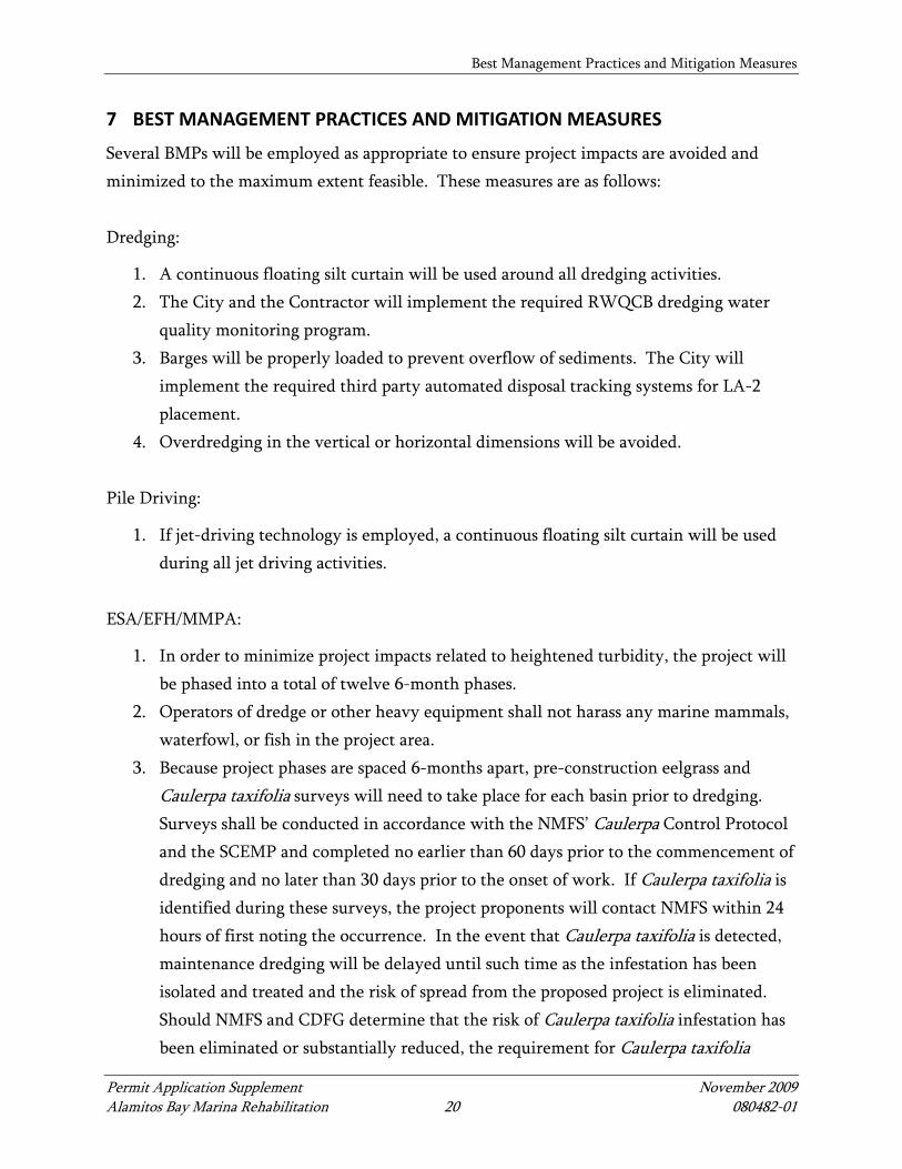
7 BEST MANAGEMENT PRACTICES AND MITIGATION MEASURES
Several BMPs will be employed as appropriate to ensure project impacts are avoided and minimized to the maximum extent feasible. These measures are as follows: Dredging:
1. A continuous floating silt curtain will be used around all dredging activities. 2. The City and the Contractor will implement the required RWQCB dredging water
quality monitoring program. 3. Barges will be properly loaded to prevent overflow of sediments. The City will
implement the required third party automated disposal tracking systems for LA-2 placement.
4. Overdredging in the vertical or horizontal dimensions will be avoided. Pile Driving:
1. If jet-driving technology is employed, a continuous floating silt curtain will be used during all jet driving activities.
ESA/EFH/MMPA:
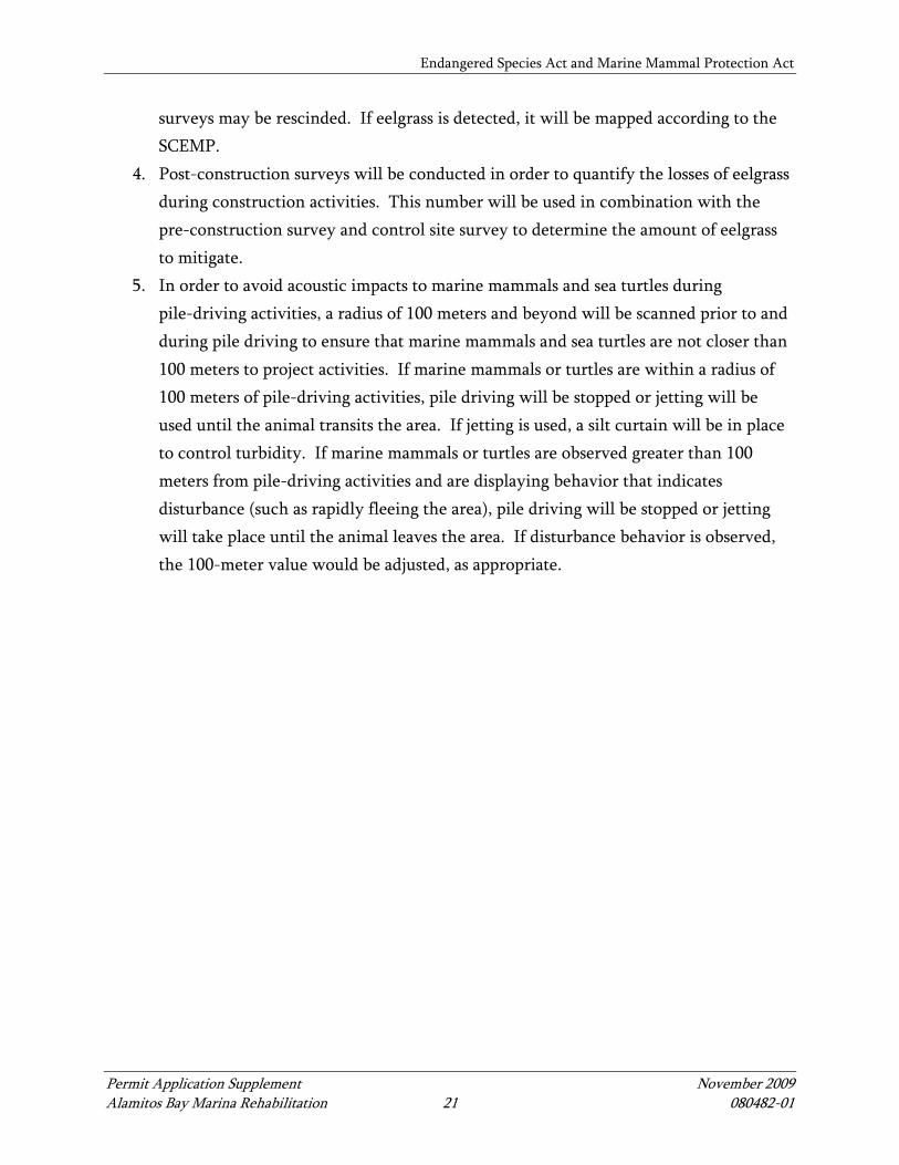
1. In order to minimize project impacts related to heightened turbidity, the project will be phased into a total of twelve 6-month phases.
2. Operators of dredge or other heavy equipment shall not harass any marine mammals, waterfowl, or fish in the project area.
3. Because project phases are spaced 6-months apart, pre-construction eelgrass and Caulerpa taxifolia surveys will need to take place for each basin prior to dredging. Surveys shall be conducted in accordance with the NMFS’ Caulerpa Control Protocol and the SCEMP and completed no earlier than 60 days prior to the commencement of dredging and no later than 30 days prior to the onset of work. If Caulerpa taxifolia is identified during these surveys, the project proponents will contact NMFS within 24 hours of first noting the occurrence. In the event that Caulerpa taxifolia is detected, maintenance dredging will be delayed until such time as the infestation has been isolated and treated and the risk of spread from the proposed project is eliminated. Should NMFS and CDFG determine that the risk of Caulerpa taxifolia infestation has been eliminated or substantially reduced, the requirement for Caulerpa taxifolia
Endangered Species Act and Marine Mammal Protection Act
Permit Application Supplement November 2009 Alamitos Bay Marina Rehabilitation 21 080482-01
surveys may be rescinded. If eelgrass is detected, it will be mapped according to the SCEMP.
4. Post-construction surveys will be conducted in order to quantify the losses of eelgrass during construction activities. This number will be used in combination with the pre-construction survey and control site survey to determine the amount of eelgrass to mitigate.
5. In order to avoid acoustic impacts to marine mammals and sea turtles during pile-driving activities, a radius of 100 meters and beyond will be scanned prior to and during pile driving to ensure that marine mammals and sea turtles are not closer than 100 meters to project activities. If marine mammals or turtles are within a radius of 100 meters of pile-driving activities, pile driving will be stopped or jetting will be used until the animal transits the area. If jetting is used, a silt curtain will be in place to control turbidity. If marine mammals or turtles are observed greater than 100 meters from pile-driving activities and are displaying behavior that indicates disturbance (such as rapidly fleeing the area), pile driving will be stopped or jetting will take place until the animal leaves the area. If disturbance behavior is observed, the 100-meter value would be adjusted, as appropriate.
References
Permit Application Supplement November 2009 Alamitos Bay Marina Rehabilitation 22 080482-01
8 REFERENCES
Chambers Group Inc. (Chambers). 2001. Preliminary Draft Dredged Material Management Plan Programmatic Environmental Impact Statement/Report for Harbors/Marinas in the Los Angeles Area. Prepared for U.S. Army Corps of Engineers, Los Angeles District.
Coastal Resources Management (CRM). 2007. Eelgrass (Zostera marina) Field Survey,
Impact Assessment, and Mitigation Plan for the Alamitos Bay Marina Renovation Project. Prepared for LSA Associates, Inc.
CRM. 2008. Analysis of potential eelgrass habitat biotic and abiotic characteristics in
Alamitos Bay Marina, Long Beach, California. Prepared for Anchor QEA, L.P. Everest International Consultants (Everest). 2009. Marine Stadium Eelgrass Mitigation Site
Assessment – Tidal Hydraulic Analysis. Prepared for Anchor QEA, L.P. California Department of Fish and Game (CDFG). 2009. California Least Tern Breeding
Survey 2008 Season. Final Report to State of California, Department of Fish and Game, South Coast Region.
NFMS. 2008. Comments on CTURTLE Listserv dated May 9, 2008. http://lists.ufl.edu/cgi-
bin/wa?A2=ind0805&L=cturtle&P=5121. TranSystems. 2009. Personal Communication with Glen Estrella.

FIGURES

Basin 6S(See Figure 8)
Basin 6N(See Figure 7)
Basin 7(see Figure 9)
Basin 5(see Figure 6)
Basin 3
(see Figure 4)
Basin 2
(see Figure 3)
Basin 4
(See Figure 5)
Basin 1
(see Figure 2)Alamitos Bay
Alamitos Peninsula
0 1000
Scale in Feet
Figure 1Overview of Work at Alamitos Bay Marina
Alamitos Bay Marina Rehabilitation
Nov
03,
200
9 4:
22pm
tgri
ga
K:\
Jobs
\080
482-
Coro
nado
Cay
s D
ock\
0804
82-0
1-Be
lling
ham
_Mar
ine\
0804
8201
-RP-
009.
dwg
Fig
1
AERIAL: NAIP 2009
0 100
Scale in Feet
Figure 2Basin 1
Alamitos Bay Marina Rehabilitation
Nov
18,
200
9 1:
34pm
tgri
ga
K:\
Jobs
\080
482-
Coro
nado
Cay
s D
ock\
0804
82-0
1-Be
lling
ham
_Mar
ine\
0804
8201
-RP-
001.
dwg
Fig
2 - B
ASI
N 1
SOURCE: TranSystems, Long Beach, CA
HORIZONTAL DATUM: NAD 83 California State Plane,Zone 6.VERTICAL DATUM: Mean Lower Low Water (MLLW).
Dredge Area at -12 and -15 ft MLLW
Proposed Dock
Existing Dock
LEGEND:
0 100
Scale in Feet
Figure 3Basin 2
Alamitos Bay Marina Rehabilitation
Nov
18,
200
9 1:
34pm
tgri
ga
K:\
Jobs
\080
482-
Coro
nado
Cay
s D
ock\
0804
82-0
1-Be
lling
ham
_Mar
ine\
0804
8201
-RP-
003.
dwg
Fig
3 - B
ASI
N 2
SOURCE: TranSystems,Long Beach, CA
HORIZONTAL DATUM: NAD 83California State Plane, Zone 6.VERTICAL DATUM: Mean LowerLow Water (MLLW).
Dredge Area at-10 ft MLLW
Proposed Dock
Existing Dock
Eelgrass
LEGEND:
0 100
Scale in Feet
Figure 4Basin 3
Alamitos Bay Marina Rehabilitation
Nov
18,
200
9 1:
35pm
tgri
ga
K:\
Jobs
\080
482-
Coro
nado
Cay
s D
ock\
0804
82-0
1-Be
lling
ham
_Mar
ine\
0804
8201
-RP-
004.
dwg
Fig
4 - B
ASI
N 3
SOURCE: TranSystems, Long Beach, CA
HORIZONTAL DATUM: NAD 83 California State Plane, Zone 6.VERTICAL DATUM: Mean Lower Low Water (MLLW).
Dredge Area at -10 ft MLLW
Proposed Dock
Existing Dock
LEGEND:
0 100
Scale in Feet
Figure 5Basin 4
Alamitos Bay Marina Rehabilitation
Nov
18,
200
9 1:
35pm
tgri
ga
K:\
Jobs
\080
482-
Coro
nado
Cay
s D
ock\
0804
82-0
1-Be
lling
ham
_Mar
ine\
0804
8201
-RP-
002.
dwg
Fig
5 - B
ASI
N 4
SOURCE: TranSystems, Long Beach, CA
HORIZONTAL DATUM: NAD 83 California State Plane,Zone 6.VERTICAL DATUM: Mean Lower Low Water (MLLW).
Dredge Area at -10 ft MLLW
Proposed Dock
Existing Dock
Eelgrass
LEGEND:
0 50
Scale in Feet
Figure 6Basin 5
Alamitos Bay Marina Rehabilitation
Nov
18,
200
9 1:
35pm
tgri
ga
K:\
Jobs
\080
482-
Coro
nado
Cay
s D
ock\
0804
82-0
1-Be
lling
ham
_Mar
ine\
0804
8201
-RP-
005.
dwg
Fig
6 - B
ASI
N 5
SOURCE: TranSystems, Long Beach, CA
HORIZONTAL DATUM : NAD 83 California State Plane, Zone 5.VERTICAL DATUM: Mean Lower Low Water (MLLW).
Dredge Area at -10 ft MLLW
Proposed Dock
Existing Dock
LEGEND:
0 60
Scale in Feet
Figure 7Basin 6N
Alamitos Bay Marina Rehabilitation
Nov
18,
200
9 1:
36pm
tgri
ga
K:\
Jobs
\080
482-
Coro
nado
Cay
s D
ock\
0804
82-0
1-Be
lling
ham
_Mar
ine\
0804
8201
-RP-
006.
dwg
Fig
7 - B
ASI
N 6
N
SOURCE: TranSystems, Long Beach, CA
HORIZONTAL DATUM: NAD 83 California State Plane,Zone 5.VERTICAL DATUM: Mean Lower Low Water (MLLW).
Dredge Area at -10 ft MLLW
Proposed Dock
Existing Dock
Eelgrass
LEGEND:

0 60
Scale in Feet
Figure 8Basin 6S
Alamitos Bay Marina Rehabilitation
Nov
18,
200
9 1:
36pm
tgri
ga
K:\
Jobs
\080
482-
Coro
nado
Cay
s D
ock\
0804
82-0
1-Be
lling
ham
_Mar
ine\
0804
8201
-RP-
007.
dwg
Fig
8 - B
ASI
N 6
S
SOURCE: TranSystems, Long Beach, CA
HORIZONTAL DATUM: NAD 83 California State Plane,Zone 5.VERTICAL DATUM: Mean Lower Low Water (MLLW).
Dredge Area at -10 ft MLLW
Proposed Dock
Existing Dock
Eelgrass
LEGEND:

0 30
Scale in Feet
Figure 9Basin 7
Alamitos Bay Marina Rehabilitation
Nov
18,
200
9 1:
36pm
tgri
ga
K:\
Jobs
\080
482-
Coro
nado
Cay
s D
ock\
0804
82-0
1-Be
lling
ham
_Mar
ine\
0804
8201
-RP-
008.
dwg
Fig
9 - B
ASI
N 7
SOURCE: TranSystems, Long Beach, CA
HORIZONTAL DATUM: NAD 83 California State Plane,Zone 5.VERTICAL DATUM: Mean Lower Low Water (MLLW).
Dredge Area at -10 ft MLLW
Proposed Dock
Existing Dock
LEGEND:


ATTACHMENT A SEDIMENT DISPOSAL PLAN APPROVAL
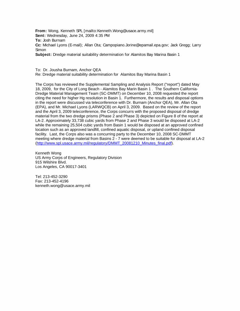
From: Wong, Kenneth SPL [mailto:[email protected]] Sent: Wednesday, June 24, 2009 4:35 PM To: Josh Burnam Cc: Michael Lyons (E-mail); Allan Ota; [email protected]; Jack Gregg; Larry Simon Subject: Dredge material suitability determination for Alamitos Bay Marina Basin 1
To: Dr. Jousha Burnam, Anchor QEA Re: Dredge material suitability determination for Alamitos Bay Marina Basin 1
The Corps has reviewed the Supplemental Sampling and Analysis Report ("report") dated May 18, 2009, for the City of Long Beach - Alamitos Bay Marin Basin 1 . The Southern California-Dredge Material Management Team (SC-DMMT) on December 10, 2008 requested the report citing the need for higher Hg resolution in Basin 1. Furthermore, the results and disposal options in the report were discussed via teleconference with Dr. Burnam (Anchor QEA), Mr. Allan Ota (EPA), and Mr. Michael Lyons (LARWQCB) on April 3, 2009. Based on the review of the report and the April 3, 2009 teleconference, the Corps concurrs with the proposed disposal of dredge material from the two dredge prisms (Phase 2 and Phase 3) depicted on Figure 8 of the report at LA-2. Approximately 33,738 cubic yards from Phase 2 and Phase 3 would be disposed at LA-2 while the remaining 25,504 cubic yards from Basin 1 would be disposed at an approved confined location such as an approved landfill, confined aquatic disposal, or upland confined disposal facility. Last, the Corps also was a concurring party to the December 10, 2008 SC-DMMT meeting where dredge material from Basins 2 - 7 were deemed to be suitable for disposal at LA-2 (http://www.spl.usace.army.mil/regulatory/DMMT_20081210_Minutes_final.pdf).
Kenneth Wong US Army Corps of Engineers, Regulatory Division 915 Wilshire Blvd. Los Angeles, CA 90017-3401 Tel: 213-452-3290 Fax: 213-452-4196 [email protected]
ATTACHMENT B MARINE STADIUM EELGRASS MITIGATION SITE ASSESSMENT – TIDAL HYDRAULIC ANALYSIS
1
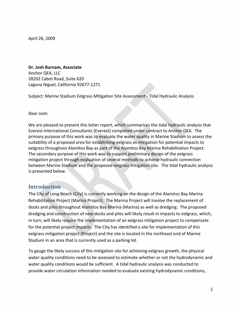
April 26, 2009 Dr. Josh Burnam, Associate Anchor QEA, LLC 28202 Cabot Road, Suite 620 Laguna Niguel, California 92677‐1271 Subject: Marine Stadium Eelgrass Mitigation Site Assessment ‐ Tidal Hydraulic Analysis Dear Josh: We are pleased to present this letter report, which summarizes the tidal hydraulic analysis that Everest International Consultants (Everest) completed under contract to Anchor QEA. The primary purpose of this work was to evaluate the water quality in Marine Stadium to assess the suitability of a proposed area for establishing eelgrass as mitigation for potential impacts to eelgrass throughout Alamitos Bay as part of the Alamitos Bay Marina Rehabilitation Project. The secondary purpose of this work was to support preliminary design of the eelgrass mitigation project through evaluation of several methods to achieve hydraulic connection between Marine Stadium and the proposed eelgrass mitigation site. The tidal hydraulic analysis is presented below.
Introduction The City of Long Beach (City) is currently working on the design of the Alamitos Bay Marina Rehabilitation Project (Marina Project). The Marina Project will involve the replacement of docks and piles throughout Alamitos Bay Marina (Marina) as well as dredging. The proposed dredging and construction of new docks and piles will likely result in impacts to eelgrass, which, in turn, will likely require the implementation of an eelgrass mitigation project to compensate for the potential project impacts. The City has identified a site for implementation of this eelgrass mitigation project (Project) and the site is located in the northeast end of Marine Stadium in an area that is currently used as a parking lot.
To gauge the likely success of this mitigation site for achieving eelgrass growth, the physical water quality conditions need to be assessed to estimate whether or not the hydrodynamic and water quality conditions would be sufficient. A tidal hydraulic analysis was conducted to provide water circulation information needed to evaluate existing hydrodynamic conditions,

2
project‐related differences in hydrodynamic conditions, and sedimentation rate differences within the mitigation site.
Marine Stadium is a relatively narrow marine waterway that is lined on both sides with riprap. At the north end of Marine Stadium, an underground culvert hydraulically connects Marine Stadium and Colorado Lagoon. The proposed eelgrass mitigation site would be located in this area as shown in Figure 1. This portion of Marine Stadium currently supports eelgrass along most of the riprap boundary. The mitigation site would be created by excavating the existing parking lot down to depths sufficient for eelgrass establishment and maintenance. Photographs taken of the mitigation site during a January 20, 2009 site visit (low tide) are shown in Figure 2. Photographs of the surrounding area are shown in Figure 3 and a photograph of the storm drain located adjacent to the mitigation site is shown in Figure 4.
Two alternatives were developed for the Project each based on different hydraulic connections between the mitigation sites and Marine Stadium. The first alternative (Alternative 1) consisted of a full hydraulic connection between the mitigation site and Marine Stadium. The second alternative (Alternative 2) was based on a limited hydraulic connection.
Under Alternative 1, the mitigation site would be connected directly to Marine Stadium with an open channel. A section of the existing riprap would be removed to allow full tidal exchange with Marine Stadium. A schematic of Alternative 1 is shown in Figure 5. A bottom elevation of ‐3 ft, MLLW (‐5.64 ft, NGVD) would extend approximately 70 ft from Marine Stadium into the proposed eelgrass mitigation site.
Under Alternative 2, the mitigation site would include a hydraulic connection (e.g., culvert or weir) that would limit the exchange of water between the mitigation site and Marine Stadium. Tidal exchange would be achieved via culvert(s) running through the existing riprap or via a weir notched into the existing riprap. Four different hydraulic configurations were evaluated as part of Alternative 2. Alternative 2A consisted of one, 1‐ft diameter culvert placed in the existing riprap about 0.5 ft above the bottom of the mitigation site. Alternative 2B consisted of one, 2‐ft diameter culvert placed at the same location. Under Alternative 2C, four, 2‐ft diameter culverts were used to connect the mitigation site and Marine Stadium. Alternative 2D consisted of one, 5‐ft wide weir with an invert elevation at ‐2.64 ft, NGVD. The alternatives analyzed as part of the tidal hydraulic analysis are summarized in Table 1.

3
Table 1. Tidal Hydraulic Analysis Alternatives
Alternative Hydraulic Connection Type Description 1 Full Removal of existing riprap 2A Limited One 1‐ft culvert 2B Limited One 2‐ft culvert 2C Limited Four 2‐ft culverts 2D Limited One 5‐ft weir
The tidal hydraulic analysis was based on comparing the results of the analysis under proposed conditions (With Project) to the results under existing conditions (No Project). Ordinarily this level of baseline comparison would be sufficient; however, there are two projects currently moving through the regulatory review process that may affect the Project and/or be affected by the Project. The City is currently working on the Colorado Lagoon Restoration Project (CLRP), which will impact tidal exchange between Marine Stadium and Colorado Lagoon. The Los Angeles County Department of Public Works (LACDPW) is currently working on the Termino Avenue Drain Project (TADP), which would re‐direct a storm drain from Colorado Lagoon into Marine Stadium. In order to assess the impact of these projects on the Project as well as to assess the impact of the Project on these projects, the tidal hydraulic analysis for Alternative 1 was performed under four baseline scenarios as summarized in Table 2. These results were adequate to assess the relative impact of the various scenario conditions so it was not necessary to analyze Alternative 2 under this range of baseline scenarios; hence only existing conditions were considered for Alternative 2. The first scenario (Scenario 1) is defined by existing conditions. The second scenario (Scenario 2) includes completion of Phase 1 of the CLRP under which portions of Colorado Lagoon would be dredged and the tidal culvert would be restored to design conditions. The third scenario (Scenario 3) includes completion of the TADP while the fourth scenario (Scenario 4) included both the CLRP and TADP.
Table 2. Baseline Scenarios
Scenario Description 1 Existing Conditions 2 Colorado Lagoon Restoration Phase 1 3 TAD Project 4 Colorado Lagoon Restoration Phase 1 and TAD Project
Hydraulic Conditions Three hydraulic conditions were analyzed – high tide, mean tide, and a 10‐year flood event occurring during mean tide. Tide conditions and storm drain flows for the tidal hydraulic
4
analysis were obtained from a prior hydrologic and water quality analysis1 conducted to support the TAD Environmental Impact Report (EIR). The two different tide conditions (high and mean tides) are depicted in Figure 6. Storm drains that discharge near the proposed eelgrass mitigation site and into Colorado Lagoon are shown in Figure 7. The LACDPW storm drain (Project 5104) located at the edge of the proposed mitigation site was observed to be non‐functional and was not simulated. The 10‐year storm drain hydrographs for existing conditions (Scenario 1) and scenarios with the TAD (Scenarios 3 and 4) are shown in Figure 8. The peak of the 10‐year flood flow is assumed to arrive at the peak of the mean tide.
Tidal Hydraulic Analysis – Overview The tidal hydraulic analysis for both alternatives was conducted in order to establish the impact of the proposed eelgrass mitigation site on the existing eelgrass area and to evaluate the suitability of hydrodynamic and water quality conditions for eelgrass growth. The impact of the proposed eelgrass mitigation site on the existing eelgrass mitigation site was evaluated by comparing velocities at the existing eelgrass area under no project and with project conditions. Due to the difference between alternatives, methodologies to determine the hydrodynamic and water quality conditions for each alternative varied to address specific hydrodynamic and water quality issues. For Alternative 1, the tidal hydraulic analysis included establishing baseline velocities to define suitable hydrodynamic conditions to support eelgrass growth, which were then compared to velocities within the proposed eelgrass mitigation site. Transport conditions were also evaluated with a particle tracking analysis to assess the water quality conditions. For Alternative 2, the major concern is whether the culvert(s) or weir will provide sufficient tidal exchange between the mitigation area and Marine Stadium; hence the tidal hydraulic analysis for Alternative 2 focused on the flushing time of the proposed mitigation site. Localized velocities near the culvert and weir exits in the eelgrass mitigation site were analyzed to see whether there may be high velocity areas not suitable for eelgrass growth.
Tidal Hydraulic Analysis – Alternative 1 The tidal hydraulic analysis for Alternative 1 was conducted using the hydrodynamic model (RMA2) that was previously developed for a hydrologic and water quality analysis to support the TAD EIR. Figure 9a shows the model grid used for the earlier study. The figure also shows the one‐dimensional elements used to represent the tidal culvert between Colorado Lagoon and Marine Stadium, as well as the Haynes and AES Alamitos Generating Stations, which intake water from Alamitos Bay and discharge it to the San Gabriel River. 1 “Termino Avenue Drain Hydrologic and Water Quality Analyses Report.” Prepared for EDAW, Inc. Prepared by Everest International Consultants, Inc. October 2005.

5
For Alternative 1, the model was modified for each scenario to account for changes in the bathymetry, hydraulic connections, and hydrology. The model grids near the mitigation site for no project and with project conditions are shown in Figures 9b and 9c, respectively. Existing bathymetry for Colorado Lagoon and the northeastern portion of Marine Stadium was based on a survey conducted in February 2004 by LACDPW. Modifications to the bathymetry of Colorado Lagoon for the Colorado Lagoon Restoration Project Phase 1 were provided by the City. The bathymetry of the remaining portion of Marine Stadium, Alamitos Bay, and the ocean was based on the NOAA chart 18749.
Hydrodynamic conditions suitable for eelgrass growth were based on the velocities occurring in the area where eelgrass is currently present under Scenario 1 (no project). Velocities were simulated for the three hydrodynamic conditions – high tide, mean tide, and 10‐year flood event. The ranges in velocity experienced at the existing eelgrass area are provided in Figure 10. Velocities were analyzed at 14 locations throughout the existing eelgrass area shown in Figure 10a. Velocities at the 14 locations that occur during the high tide condition are shown in Figure 10b. As expected for tide dominant conditions, velocities are small, less than 0.1 ft/sec, with four oscillations (rise and fall) in the velocities corresponding to the tide fluctuations (e.g., high to low tide). In general, velocities are highest midway between high and low tide. To illustrate the oscillations with the ocean tide, water surface elevations of the tide and water level in Colorado Lagoon (green line) are also shown for comparative purposes. Comparison of the velocities to the tide elevations (gray line) shows the highest velocity oscillation following the first high and low tide (i.e., largest tide range). However, the timing of the peak velocities occurs closer at the lowest tide, as opposed to midway between high and low tide. This can be explained by comparing the velocities to the water levels in Colorado Lagoon (green line). The timing of the peak velocities occurs midway between the high and low water elevations in Colorado Lagoon. Due to the close proximity of the existing eelgrass area to the tidal culvert, the hydrodynamic conditions are dominated by tidal flows in and out of the tidal culvert. The influence of the tidal culvert is less pronounced for smaller tide ranges, as indicated by velocities during a mean tide condition shown in Figure 10c. Again, the velocities show the four oscillations with the tide, but the peak velocities are less than 0.05 ft/sec. During the 10‐year flood event, velocities at the existing eelgrass area also depend on flows in and out of the tidal culvert. Comparison of the velocities to the water elevations in Colorado Lagoon shows that the highest velocities correspond to the flood flows exiting the lagoon and entering Marine Stadium. Overall, the tidal hydraulic analysis of existing conditions indicated that velocities at the existing eelgrass area are generally small, less than 0.1 ft/sec, and are affected by flows in and out of the tidal culvert.
6
The proposed eelgrass mitigation site was first evaluated based on changes in hydrodynamic conditions at the existing eelgrass area to determine whether the proposed mitigation site will have any impact on the existing eelgrass areas. Velocities at the existing eelgrass area were compared between Scenario 1 no project (hereafter referred to as Baseline 1) and Scenario 1 with project (hereafter referred to as Project 1) in Figure 11. Velocities were compared under the three hydrodynamic conditions – high tide, mean tide, and a 10‐year flood event. Velocities were compared at the same 14 locations throughout the existing eelgrass area, as shown in Figure 11a. The Baseline 1 velocities are indicated by red lines, while the Project 1 velocities are shown in blue. For all three hydrodynamic conditions, the Project 1 velocities are similar to Baseline 1, indicating that the proposed eelgrass mitigation site would have minimum impact on the hydrodynamic conditions of the existing eelgrass area. It is expected that for the other three scenarios, with project conditions would also not result in significant changes to hydrodynamic conditions in the existing eelgrass area.
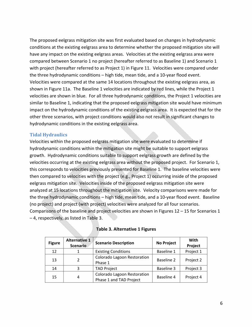
Tidal Hydraulics Velocities within the proposed eelgrass mitigation site were evaluated to determine if hydrodynamic conditions within the mitigation site might be suitable to support eelgrass growth. Hydrodynamic conditions suitable to support eelgrass growth are defined by the velocities occurring at the existing eelgrass area without the proposed project. For Scenario 1, this corresponds to velocities previously presented for Baseline 1. The baseline velocities were then compared to velocities with the project (e.g., Project 1) occurring inside of the proposed eelgrass mitigation site. Velocities inside of the proposed eelgrass mitigation site were analyzed at 15 locations throughout the mitigation site. Velocity comparisons were made for the three hydrodynamic conditions – high tide, mean tide, and a 10‐year flood event. Baseline (no project) and project (with project) velocities were analyzed for all four scenarios. Comparisons of the baseline and project velocities are shown in Figures 12 – 15 for Scenarios 1 – 4, respectively, as listed in Table 3.
Table 3. Alternative 1 Figures
Figure Alternative 1 Scenario
Scenario Description No Project With Project
12 1 Existing Conditions Baseline 1 Project 1
13 2 Colorado Lagoon Restoration Phase 1
Baseline 2 Project 2
14 3 TAD Project Baseline 3 Project 3
15 4 Colorado Lagoon Restoration Phase 1 and TAD Project
Baseline 4 Project 4
7
Comparison of the Baseline 1 and Project 1 velocities are shown in Figure 12. Locations of the baseline velocities (red circles) located in the existing eelgrass area and project velocities (blue circles) located inside the proposed eelgrass mitigation site are shown in Figure 12a. Velocities under the three hydrodynamic conditions are compared in Figures 12b – 12d. In each panel, Baseline 1 velocities are shown in red, while Project 1 velocities are shown in blue. The ocean tide and water surface elevation in Colorado Lagoon are also shown for comparison purpose. Note that Baseline 1 velocities are the same as those presented previously in Figure 10. Baseline 1 velocities are dominated by flows from the tidal culvert as indicated by peak velocities occurring as water levels within Colorado Lagoon drop. For the high tide condition, Project 1 velocities within the mitigation site are smaller than Baseline 1 velocities and do not show the drastic peak in velocity observed in Baseline 1. Project 1 velocities for the mean tide and 10‐year flood event conditions also show smaller velocities than Baseline 1, as well as less oscillation in velocity. The reduced peak velocities for Project 1 indicate that hydrodynamic conditions in the proposed eelgrass mitigation site are less influenced by flows in and out of the tidal culvert.
Hydrodynamic conditions for Scenario 2 with the Colorado Lagoon Restoration Project Phase 1 are compared in Figure 13. Baseline 2 represents velocities at the existing eelgrass area, while Project 2 indicates the velocities inside the proposed eelgrass mitigation site. Effects of cleaning out the tidal culvert are illustrated by the water elevations in Colorado Lagoon coinciding closer to the ocean tide and the overall higher velocities for Baseline 2 as compared to Baseline 1, especially for the mean tide and a 10‐year flood event. The Project 2 velocities within the mitigation site are lower compared to the Baseline 2 velocities. The high and mean tide conditions show a more even oscillation. Similarly, the peak velocities during the 10‐year flood are reduced and show little increase from the tide only conditions.
The baseline and project velocities for Scenario 3 with the TAD Project are shown in Figure 14. Since the TAD does not affect the tide only condition, the velocities for high and mean tide conditions are the same as Baseline 1. However, Baseline 3 velocities for the 10‐year flood vary from Baseline 1 due to the diversion of the TAD from Colorado Lagoon to Marine Stadium. Hence, two peaks in velocities occur with one corresponding to the peak flow from the TAD and one peak corresponding to flows from Colorado Lagoon, but the peak velocities are less than the high tide peak velocities. Again, Project 3 velocities are lower than the Baseline 3 velocities and show less variation in magnitude.
Figure 15 contains the comparisons of hydrodynamic conditions under Scenario 4 with both the Colorado Lagoon Restoration Phase 1 and TAD Project. For the Baseline 4 velocities, results under the high and mean tide conditions are similar to Baseline 2, while the 10‐year flood
8
results have the same trends as Baseline 3. Project 4 velocities are consistent with previous results and are less than the baseline velocities.
Overall, the predicted velocities within the proposed eelgrass mitigation site under Alternative 1 are less than velocities within the existing eelgrass area. These lower velocities are expected since the proposed eelgrass site is in an area more sheltered than the existing eelgrass area. However, as discussed earlier, the predicted tidal velocities within the existing eelgrass area and eelgrass mitigation site are relatively small and these predicted velocities are well within the uncertainty and accuracy of tidal hydraulic modeling. Consequently, the reduction in tidal velocities predicted for the eelgrass mitigation site under Alternative 1 is not substantial.
Transport Conditions Potential sediment sources near the mitigation site are the tidal culvert and storm drain discharging into Marine Stadium. The storm drain at the corner of the mitigation site was observed to be non‐functional so it was not considered in this analysis. For the TAD Project, a new storm drain discharging into Marine Stadium would be constructed and was considered for scenarios with the TAD Project.
In order to assess the sediment transport into the mitigation site, a particle tracking analysis was conducted to determine whether or not hydrodynamic conditions are sufficient to transport sediment into the mitigation site. This analysis tracks the movement of a particle based on the hydrodynamic conditions. Since settling or deposition of the particle is not considered, the particle track represents the maximum travel distance possible. The particle tracking analysis was done using the three hydrodynamic conditions – high tide, mean tide, and a 10‐year flood event. Five particles were release from the tidal culvert at the locations indicated by the red dots in Figure 16 during peak flow from Colorado Lagoon into Marine Stadium. For Scenarios 3 and 4 with the TAD project, transport from the TAD was also evaluated with five particles at the locations shown in Figure 16.
For each scenario, particle tracks were produced for no project and with project conditions, again referred to as baseline and project conditions, respectively. Particle tracks under Scenario 1 are shown in Figure 17. In the figure, results for the Baseline 1 and Project 1 are compared for each hydrodynamic condition. For all three hydrodynamic conditions, results for the Project 1 are similar to the Baseline 1. Under Scenario 1, transport does not occur into the mitigation site. Particle tracking results of the other scenarios are provided in Figures 18 – 20. Again, particle tracks for project conditions are similar to baseline conditions and particles were not transported into the mitigation site. Particle tracking results from the TAD are found in Figures 21 and 22 for Scenarios 3 and 4, respectively. Particle tracks for project conditions are similar to baseline scenarios. The particle tracking analysis indicates hydrodynamic conditions
9
at Marine Stadium do not have a tendency to transport particles into the proposed eelgrass mitigation site.
Based on the particle tracking analysis, hydrodynamic conditions for Alternative 1 with the proposed eelgrass mitigation site are not likely to transport sediment from the tidal culvert or new TAD into the mitigation site. Hence, the sedimentation rate within the proposed eelgrass is expected to be similar to that at the existing eelgrass area.
Tidal Hydraulic Analysis – Alternative 2 Analysis of Alternative 1 indicated that transport conditions in Marine Stadium are not likely to transport sediment or pollutants to the proposed eelgrass mitigation site, which would still hold for transport conditions under Alternative 2 under which, limited tidal exchange between Marine Stadium and the proposed eelgrass mitigation site would be provided by culverts or weirs. This limited tidal exchange, however, may result in poor tidal flushing for the mitigation site that could lead to poor water quality (e.g., low dissolved oxygen or algae growth). Hence for Alternative 2, the tidal hydraulic analysis focuses on estimating tidal exchange and flushing between Marine Stadium and the proposed eelgrass mitigation site. In addition, velocities in the vicinity of the culverts and weirs within the mitigation site are also examined to see whether there would be localized high velocity areas that may not be suitable for eelgrass.
A different methodology was developed for Alternative 2 to address tidal exchange and tidal flushing within the proposed eelgrass mitigation site. Tidal hydrodynamic conditions (e.g., velocities and water elevations) for Alternative 2 were determined using a link node model known as KAI. KAI is a one‐dimensional hydraulic model capable of simulating flows through hydraulic control structures such as culverts and weir. Tidal exchange between the proposed eelgrass mitigation site and Marine Stadium was simulated based on a mean tide. Water levels and flows over an average tide condition were then used to determine the rate of water exchange for a flushing analysis to evaluate the mixing and flushing conditions within the mitigation site.
Tidal Hydraulics The tidal hydraulics were determined by simulating water levels and velocities between the mitigation site and Marine Stadium. Results for Alternative 2A (one 1‐ft culvert) are presented in Figure 23. The top panel of the figure shows the water surface elevations within the mitigation site and tide at Marine Stadium. The results indicate that there is a phase lag and slight muting of the water elevations within the proposed eelgrass mitigation site compared to the tide in Marine Stadium due to the limited hydraulic connection. The bottom panel of Figure 23 shows the flow and velocity through the culvert with positive and negative values indicating
10
flow into and out of the mitigation site, respectively. As expected, flows and velocities through the culvert oscillate with the tide with peak flows and velocities occurring midway between high and low tide. For this alternative, the peak velocity through the culvert under the mean tide range is 4.3 ft/sec.
Tidal hydraulic results for Alternative 2B (one 2‐ft culvert) are shown in Figure 24. As shown in the figure, the larger culvert size alleviates the slight phase lag and muting within the proposed eelgrass mitigation site as indicated by the same water surface elevations as the tide. With the larger culvert, the velocities are also lower than those for Alternative 2A with a maximum velocity of 1.2 ft/sec.
The water surface elevations, velocities, and flows for Alternative 2C (four 2‐ft culverts) are provided in Figure 25. Water surface elevations indicate no tidal muting at the proposed mitigation site for this alternative. While the four culverts provide similar flow as the other two alternatives, the maximum velocity through the culvert is about 0.3 ft/sec, which is significantly lower than the other two alternatives.
Alternative 2D simulates the use of a weir to provide tidal flow to the proposed eelgrass mitigation site. Tidal hydraulic results based on a 5‐ft wide, rectangular weir are illustrated in Figure 26. Water surface elevations within the mitigation site are the same as the tide within Marina Stadium indicating no tidal muting at the site. Maximum velocities are similar in magnitude to Alternative 2B (1.2 ft/sec). Flows through the weir are consistent with the other limited hydraulic connection alternatives.
Tidal Flushing The tidal exchange or volume of water entering the proposed eelgrass mitigation site over a mean tidal cycle was used to determine the tidal flushing time, which represents the time it takes for the volume of water in the mitigation site to be replaced with tidal water from Marine Stadium, assuming complete mixing. The flushing time analysis is useful as a screening level evaluation for Alternative 2. Long flushing time means stagnant water in the mitigation site and stagnant water is an indicator of potential poor water quality.
The tidal flushing time, defined as the ratio of the volume of water in the mitigation site at mean sea level to the volume of water entering the mitigation site each day, is calculated for each of the alternatives based on the tidal hydraulic analysis results discussed earlier. The estimated tidal flushing times for the four alternatives are listed in Table 4. As shown in the table, the flushing times for all four alternatives are approximately the same (0.5 days); hence, on average the volume of water within the mitigation site can be replaced about twice per day by water from within Marine Stadium assuming complete and uniform mixing within the
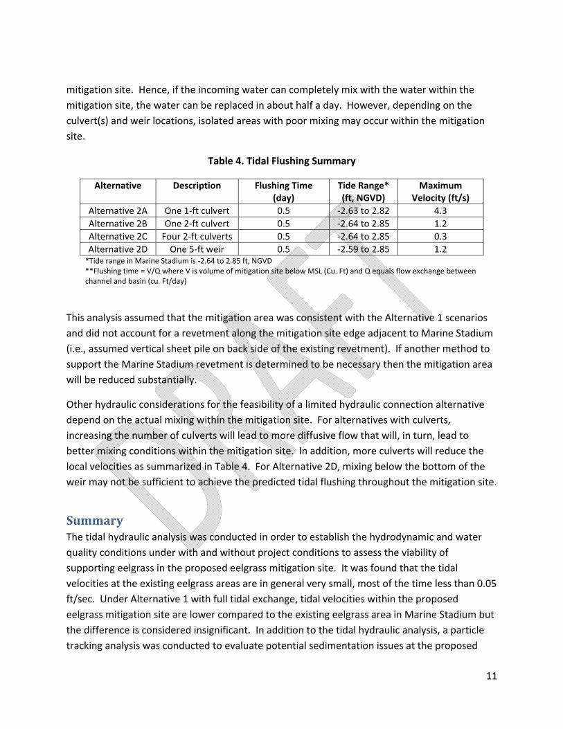
11
mitigation site. Hence, if the incoming water can completely mix with the water within the mitigation site, the water can be replaced in about half a day. However, depending on the culvert(s) and weir locations, isolated areas with poor mixing may occur within the mitigation site.
Table 4. Tidal Flushing Summary
Alternative Description Flushing Time (day)
Tide Range* (ft, NGVD)
Maximum Velocity (ft/s)
Alternative 2A One 1‐ft culvert 0.5 ‐2.63 to 2.82 4.3 Alternative 2B One 2‐ft culvert 0.5 ‐2.64 to 2.85 1.2 Alternative 2C Four 2‐ft culverts 0.5 ‐2.64 to 2.85 0.3 Alternative 2D One 5‐ft weir 0.5 ‐2.59 to 2.85 1.2 *Tide range in Marine Stadium is ‐2.64 to 2.85 ft, NGVD **Flushing time = V/Q where V is volume of mitigation site below MSL (Cu. Ft) and Q equals flow exchange between channel and basin (cu. Ft/day)
This analysis assumed that the mitigation area was consistent with the Alternative 1 scenarios and did not account for a revetment along the mitigation site edge adjacent to Marine Stadium (i.e., assumed vertical sheet pile on back side of the existing revetment). If another method to support the Marine Stadium revetment is determined to be necessary then the mitigation area will be reduced substantially.
Other hydraulic considerations for the feasibility of a limited hydraulic connection alternative depend on the actual mixing within the mitigation site. For alternatives with culverts, increasing the number of culverts will lead to more diffusive flow that will, in turn, lead to better mixing conditions within the mitigation site. In addition, more culverts will reduce the local velocities as summarized in Table 4. For Alternative 2D, mixing below the bottom of the weir may not be sufficient to achieve the predicted tidal flushing throughout the mitigation site.
Summary The tidal hydraulic analysis was conducted in order to establish the hydrodynamic and water quality conditions under with and without project conditions to assess the viability of supporting eelgrass in the proposed eelgrass mitigation site. It was found that the tidal velocities at the existing eelgrass areas are in general very small, most of the time less than 0.05 ft/sec. Under Alternative 1 with full tidal exchange, tidal velocities within the proposed eelgrass mitigation site are lower compared to the existing eelgrass area in Marine Stadium but the difference is considered insignificant. In addition to the tidal hydraulic analysis, a particle tracking analysis was conducted to evaluate potential sedimentation issues at the proposed

12
mitigation site. It was found that hydrodynamic conditions in Marine Stadium are unlikely to transport sediment from the tidal culvert or the new Termino Avenue Drain into the proposed eelgrass mitigation site. Hence, the sedimentation rate within the proposed eelgrass mitigation site is expected to be similar to that experienced at the existing eelgrass area.
With limited hydraulic connection between the proposed mitigation site and Marine Stadium under Alternative 2, the major concern for this alternative is whether the use of culvert(s) or weir could provide adequate tidal exchange (i.e. tidal flushing) between the mitigation area and outside. Four different alternatives were analyzed each with different hydraulic connections (three based on the use of culverts and one based on the use of a weir). The results indicate that all four alternatives could provide adequate tidal flushing for the proposed mitigation area with an average flushing time of about half a day. However, even though the use of a single culvert could provide similar flushing as the use of multiple culverts, there are some advantages of using multiple culverts. First, the use of multiple culverts can provide more diffusive flow throughout the mitigation site, hence promoting better mixing within the mitigation site and minimizing the potential formation of stagnant areas. Second, the use of multiple culverts (or larger diameter) can result in smaller discharge velocity from the culvert, hence reducing the chance of local scour. For the weir alternative, even though it could provide similar tidal flushing in the mitigation site, it is less preferable compared to the culvert alternatives because of the potential for poor mixing below the bottom elevation of the weir.
Please contact me via email at [email protected] or via telephone at (562) 435‐9309 if you have any questions regarding this report. Sincerely, David G. Cannon, MCE, PE President/Principal Engineer Attachments (26: Figures 1 ‐ 26)