Embed Size (px)
Citation preview

A System for Wearable Audio
Navigation (SWAN)
Integrating Advanced Localization
and Auditory Display
Frank Dellaert and Bruce Walker
College of Computing, School of Psychology
Georgia Institute of Technology
NSF IIS-0534332

Outline
!Motivation
!Localization
!GPS
!Vision-based
!Auditory Display & Sonification
!Evaluation/Results
!Future Directions

Motivation for SWAN
Trailhead (P0)
Pivot Point
Transition Path
Best Path (Track)
Point where "next beacon"becomes audible
!System for Wearable Audio Navigation
!Wayfinding tool for those who cannot
look or cannot see
!Accessibility applications (blind)
!Tactical applications

park
Wayfinding via Auditory Display
! Determine user’s location
! Figure out what’s around
them (parks, curbs, poles,
buildings, benches, etc.)
! Represent each object
with unique sounds
! Listener learns what a
location “sounds like”
! Also add audio waypoints
along a path to destination
pole
waypoint
curb

waypoint
Attach Sounds to Objects: How?
! Accurate Head Pose
! Transform Object into head-
centered coordinates
! 3D Sonification
! 6DOF Needed !
! GPS can’t do it alone

SWAN System Overview
Server
VRPN MERGE SWAN
GIS
GPS1
GPS2
Compass
iCube
Temperature
Time
Etc.
Sensors
Local cache
Camera
processing
POSE

Localization
!Multiple Sensors, Sensor Fusion Required
!Cameras
!Maps
!GPS
!Compass
!Head tracker
!Thermometer
!Light meter
!Clock, calendar
! etc.
Particle Filters
!Samples approximate 2D pose probability density

Map-based Priors
!Maps fetched
from GIS
!Biases particle
filter to stay on
course

Vision-Based Localization
!Up front: Build a database

Vision-based Localization (run-time)
! At run-time:
Accurate 6DOF
localization using a
multi-camera rig
! FPGA hardware for real-
time performance
waypoint

DOG Feature Detection
!Difference Of Gaussian Filters at Different
Scales, Lowe, IJCV 2004
With Kai Ni

Affine-invariant Feature Descriptors
! Invariant to affine deformations
! Mikolajczyk & Schmid, ECCV 2002
! Appearance is then compressed using PCA
(40 dimensions, 160 bytes per landmark)

Database: Structure from Motion
with Michael Kaess

Animation

Run-time: Custom Hardware
4 Cameras covering
the viewing circle
FPGA for Real-time
Feature Detection
Xscale Processor
for Real-Time
Localization
with Daniel Walker
and Tucker Balch

Recent Prototype :-)
!4 Firewire
cameras on a
single bus
!Connected to a
laptop

Typical Output of Feature Detector Stage

Multi-camera Localization
!Maximum a-
posteriori estimation:
!Pose R,t given >3
feature measurements

Multi-camera Localization (cont’d)
!MAP = Least-squares
!RANSAC w 3 points

Preliminary “Real-time” Results
!1.6GHz Pentium II Laptop
!Approx. 5 secs per frame

SWAN Auditory Display
!Navigation Beacons!Spatialized audio beacons form a path
which can be followed
!Objects & obstacles! e.g., a desk in the hall; phone booth
!Surface Transitions! e.g., sidewalk to grass; start of stairway
!Location! e.g., lecture hall; intersection; office
!Annotations! e.g., “Puddle here whenever it rains”
! e.g., “Ramp on left side of entrance”
Recordedspeech orTTS
Trailhead (P0)
Pivot Point
Transition Path
Best Path (Track)
Point where "next beacon"becomes audible
Spatialized
audio earcon

System Evaluation
!Does SWAN help the user safely accomplish
specific tasks?
!Navigation effectiveness
!Situational awareness
!Movement speed, efficiency
!Exploration of novel environment
!Comfort, satisfaction
!Safety

Auditory Display: Some Factors to Evaluate
!Beacon Sound
!Capture Radius
!Sound device
!headphones vs. bonephones

Sound Design: “Good” Beacons
0
20
40
60
80
100
120
0 20 40 60 80 100 120 140

Sound Design: Bad Beacons (!)
0
20
40
60
80
100
120
140
0 20 40 60 80 100 120 140
Sound design matters!!Sound design matters!!

Capture Radius: Real-World Interaction
! You never exactly reach waypoint
! Capture radius = distance from the waypoint that is
“close enough”
! The “next beacon” sound begins
! Intended to allow for more natural walking around
corners and turns
! Participants in the study “bounced” off edge of
capture radius
! Artifact of movement with flight stick in VR (not real
walking)
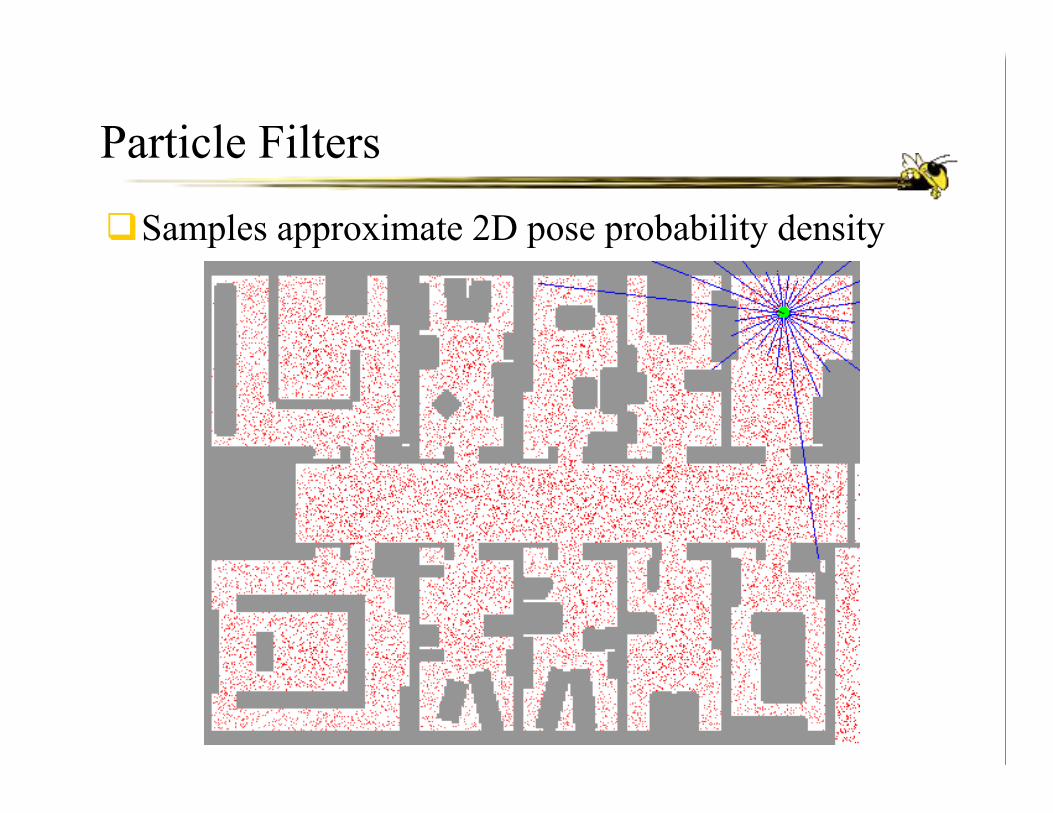
Effect of CR on Rate of Travel
Effect of Capture Radius on Rate
0
0.2
0.4
0.6
0.8
1
1.2
1.4
1.6
Small Medium Large
Capture Radius
Co
mp
leti
on
Rate
(u
nit
s p
er s
ec.)

Effect of CR on Path Efficiency (accuracy)
Effect of Capture Radius for Efficiency
0
20
40
60
80
100
120
Small Medium Large
Capture Radius
Path
Len
gth
Eff
icie
ncy (
percen
t)

Capture Radius: Findings
!Speed-accuracy tradeoff based on the size of the
capture radius
!Medium capture radius had the slowest rate, but also had
the greatest efficiency (accuracy)
!Capture radius must be considered in design of
navigation interfaces
!Depends on goals
!Stay on path or move quickly?

Sound Hardware
!Headphones
!Benefits
!Problems
!Bone conduction headphones (bone phones)
!Benefits
!Issues

Bone Phones
! Bone conduction
! Discrete
! Ears open (or plugged)
! Stereo separation (?)

Bonephone Research
!Psychophysics
!Hearing thresholds
!Frequency response
!Practical Applications
!Lateralized sound: speech separation
!“Ready Charlie” task (with Brungart, Simpson, et al.)
!Spatialized sound: SWAN
!Need “BRTFs” (bone related transfer function)

Bonephones Threshold
Walker & Stanley (2005)

Bonephones CRM Data: ILDs & ITDs
Walker, Stanley, Iyer, Simpson, & Brungart (2005)
100
80
60
40
20
0
100
80
60
40
20
0
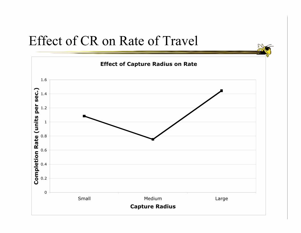
Future Directions
! Lots of "live" tests (in addition to in the VR)
! sighted and visually impaired participants
! indoors, outdoors, and mixed (the *real* test!)
! Integrating more pedestrian-level GIS data
! including accessibility information
! Expanding to more "discover and explore" tasks, in addition
to simple wayfinding
! Using the cameras for more tasks
! face recognition, object identification, text/OCR
! Expand to different user populations
! fire fighters, police, military

The End
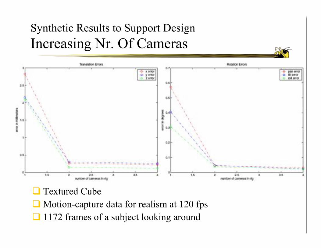
Synthetic Results to Support Design
Increasing Nr. Of Cameras
! Textured Cube
! Motion-capture data for realism at 120 fps
! 1172 frames of a subject looking around

Synthetic Results to Support Design
Increasing Frame Rate
! 3386 frames, subject walking and looking in various directions
! Frame rates were 5,8,10,12, 15, 20, 30, 40, 60, and 120 fps