Embed Size (px)
Citation preview

CITY OF ARMADALE
A G E N D A
OF DEVELOPMENT SERVICES COMMITTEE TO BE HELD IN THE COMMITTEE ROOM, ADMINISTRATION CENTRE, 7 ORCHARD AVENUE, ARMADALE ON MONDAY, 15 AUGUST 2011 AT 7:00 PM. A meal will be served at 6:15 pm PRESENT: APOLOGIES: OBSERVERS: IN ATTENDANCE:

DEVELOPMENT SERVICES COMMITTEE MEETING 15 AUGUST 2011
2
DISCLAIMER The Disclaimer for protecting Councillors and staff from liability of information and advice given at Committee meetings to be read by the Chairman. DECLARATION OF MEMBER’S INTERESTS QUESTION TIME Minimum time to be provided – 15 minutes (unless not required). CONFIRMATION OF MINUTES RESOLVED
Minutes of the Development Services Committee Meeting held on 18 July 2011, to be confirmed.
Moved Cr _______________ Carried/Lost ( )

DEVELOPMENT SERVICES COMMITTEE MEETING 15 AUGUST 2011
3
ITEMS REFERRED FROM INFORMATION BULLETIN – ISSUE No.14/2011 The following items were included for information in the “Development Services” section -
Outstanding Matters & Information Items Report on Outstanding Matters - Development Services Committee Dept of Planning Black Cockatoo Mapping Project Local Govt Reference Group Minutes of Meeting 25th May 2011 Local Govt Reference Group Minutes of Meeting 27th July 2011 Perth Region NRM – Newsletter – 6th July 201 Health
Health Compliance Report for the month of July 2011 Planning
Planning Services Report for the month of July 2011 Reviews before the State Administrative Tribunal (SAT) Town Planning Scheme No.4 - Amendment Action Table Subdivision Applications - WAPC Approvals/Refusals - July 2011 Subdivision Applications - Report on Lots Registered for 2011/2012 PAW Closure Report - Significant Actions during July 2011 Road Naming Report 2011/12 & consequential action of Council Recommendation Building
Building Services Manager’s Report for July 2011 Building Compliance Report for the month of July 2011 Building Applications Monthly Statistics - July 2011 If any of the items listed above requires clarification or a report for a decision of Council, this item is to be raised for discussion at this juncture. PRESENTATION
Briefing on Planning Compliance
- by Senior Liaison & Compliance Officer, Brendan Braithwaite

DEVELOPMENT SERVICES COMMITTEE
INDEX
15 AUGUST 2011
SCHEME AMENDMENTS & STRUCTURE PLANS
PROPOSED AMENDMENT TO MRS & LOCAL TOWN PLANNING SCHEME AND PROPOSED STRUCTURE PLAN FOR LOT 33 CONNELL AVE, KELMSCOTT (PRIES PARK) ----------7
PROPOSED INITIATION OF TEXT AMENDMENT NO.63 TO TPS NO.4 &
REVIEW OF PLANNING POLICY 2.2 - REFLECTIVE MATERIAL ON RESIDENCES -------------------34
MISCELLANEOUS
RESIDENTIAL DESIGN CODES REVIEW -----------------------------------------------------------------------------44

DEVELOPMENT SERVICES
COMMITTEE
PLANNING
DEVELOPMENT SERVICES COMMITTEE MEETING – Scheme Amendments & Structure Plans 15 AUGUST 2011
6DEVELOPMENT SERVICES COMMITTEE MEETING – Scheme Amendments & Structure Plans 15 AUGUST 2011
6
DEVELOPMENT SERVICES COMMITTEE MEETING – Scheme Amendments & Structure Plans 15 AUGUST 2011
7
PROPOSED AMENDMENT TO METROPOLITAN REGION SCHEME AND LOCAL TOWN PLANNING SCHEME AND PROPOSED STRUCTURE PLAN FOR LOT 33 CONNELL AVENUE KELMSCOTT (PRIES PARK) WARD
: RIVER
DATE
: 6 July 2011
REF
: MK
RESPONSIBLE MANAGER
: EMPS
APPLICANT
: City of Armadale
LANDOWNER
: City of Armadale
SUBJECT LAND
: Lot 33 Connell Avenue Kelmscott
ZONING MRS TPS No.4
: :
Rural Rural Living 2
In Brief:
Council engaged Planning Consultancy Burgess Design to carry out the necessary planning studies to support the rezoning of the above property under both the Metropolitan Region Scheme (MRS) and Town Planning Scheme No.4 (TPS 4).
All documentation has now been received from Council’s Planning Consultants to enable the project to be advanced to the stage of requesting the Western Australian Planning Commission (WAPC) to initiate an amendment to the MRS.
Recommend that Council request the WAPC initiate an amendment to the Metropolitan Region Scheme to rezone Lot 33 Connell Avenue Kelmscott from “Rural” to “Urban”.
Tabled Items Nil. Officer Interest Declaration Nil. Strategic Implications 2.1 Long term planning and development that is guided by a balance between economic,
social and environmental objectives. 2.1.1 Review, update and implement the City’s Town Planning Scheme, taking into account
the Local Biodiversity Strategy and other environmental considerations. Legislation Implications Planning and Development Act 2005 Town Planning Regulations 1967 Metropolitan Region Scheme Town Planning Scheme No.4
DEVELOPMENT SERVICES COMMITTEE MEETING – Scheme Amendments & Structure Plans 15 AUGUST 2011
8

DEVELOPMENT SERVICES COMMITTEE MEETING – Scheme Amendments & Structure Plans 15 AUGUST 2011
9
Policy / Local Law Implications Local Planning Strategy 2005 (COA) Active Sporting Reserves Needs Assessment and Feasibility Study 2008 (COA) State Planning Policy 3 – Urban Growth and Settlement (WAPC) State Planning Policy 2.5 – Agricultural and Rural Land Use Planning (WAPC) State Planning Policy 2.8 –Bushland Policy for the Perth Metropolitan Region (WAPC) State Planning Policy 2.10 – Swan-Canning River System (WAPC) State Planning Policy 3.4 Natural Hazards and Disasters (WAPC) State Planning Policy 4.2 Activity Centres for Perth and Peel (WAPC) Development Control Policy 1.9 Amendment to Region Schemes (WAPC) Liveable Neighbourhoods (WAPC) Directions 2031 for the Perth Metropolitan Region (WAPC) Budget / Financial Implications Urban zoning of Lot 33 would enhance financial returns of the sale of the land asset. Forward budget estimates for the sale of Lot 33 Connell Avenue have been made in the City’s 15 year plan. In respect to the 15 year Financial Plan Corporate Services Directorate advises that Council’s 2008-2023 Plan for the Future is significantly supported by the sale of Lot 33 in order to fund a number of construction projects throughout the City. In 2008 a gross estimated sale price of approximately $10.8 million, based on sale in 2012, was determined. This would be subject to revision as sale is not likely to occur until 2013 – 2014. In 2008, the total estimated funds available, after GST payments and Reserve fund transfers (70% transfer of net sale proceeds into revenue generating investments) have been conducted, were approximately $3.0 million. Projects that are proposed to be either completely or partially funded by the proceeds from the sale include:
• Morgan Park Development (2013) - $200k • William Skeet Reserve Development (2014) - $150k • Palomino Reserve Development (2014) - $250k • Alfred Skeet Reserve Development (2012) - $350k • Development of Recreational Reserves (Various) (Annually) - $2.5m • North Forrestdale Sporting Facility (Piara Waters) (2014) - $3.0m • Wungong Community Facility (Central) (2016) - $2.0m • Wungong Community Facility (West) (2020) - $1.0m
Approximately $6.8 million of the sale funds is intended to be directly invested in the first 12 months following the sale. A modest rate of return of this $6.8 million at, say, 7% per annum, paid monthly, equates to approximately $491,000 in compounded interest earnings. A Business Plan would be required to be prepared prior to sale of the land.

DEVELOPMENT SERVICES COMMITTEE MEETING – Scheme Amendments & Structure Plans 15 AUGUST 2011
10
DEVELOPMENT SERVICES COMMITTEE MEETING – Scheme Amendments & Structure Plans 15 AUGUST 2011
11
It is noted that whilst the City continues to hold Lot 33, no rates are collectable. Once all development restrictions are enforced on the Pries Park land site, approximately 150 or more lots could possibly be developed and, consequently, rated. Taking an estimated, and conservative, calculation of each rate notice of, say, $1,000, each year Council could realise annual rate revenue of approximately $150,000 from this residential cell. Consultation
Development Control Unit If initiated, the scheme amendments and the structure plan will undergo a process of
advertising for public submissions in-accordance with the requirements of the Town Planning Regulations 1967 and the City of Armadale Town Planning Scheme No.4. They also undergo environmental assessment by the EPA under Section 48A of the Environmental Protection Act 1986.
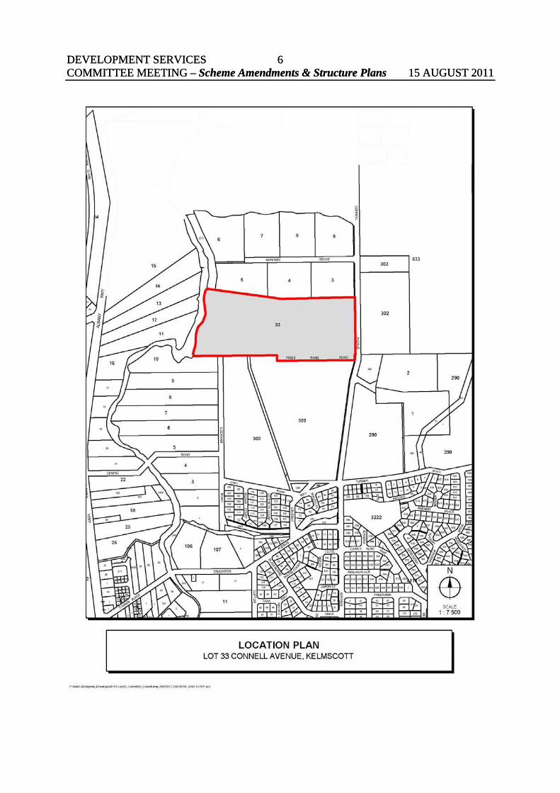
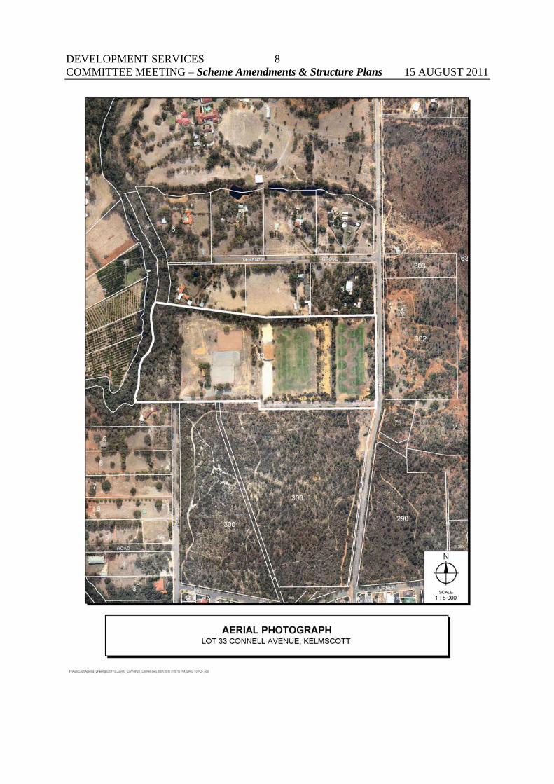
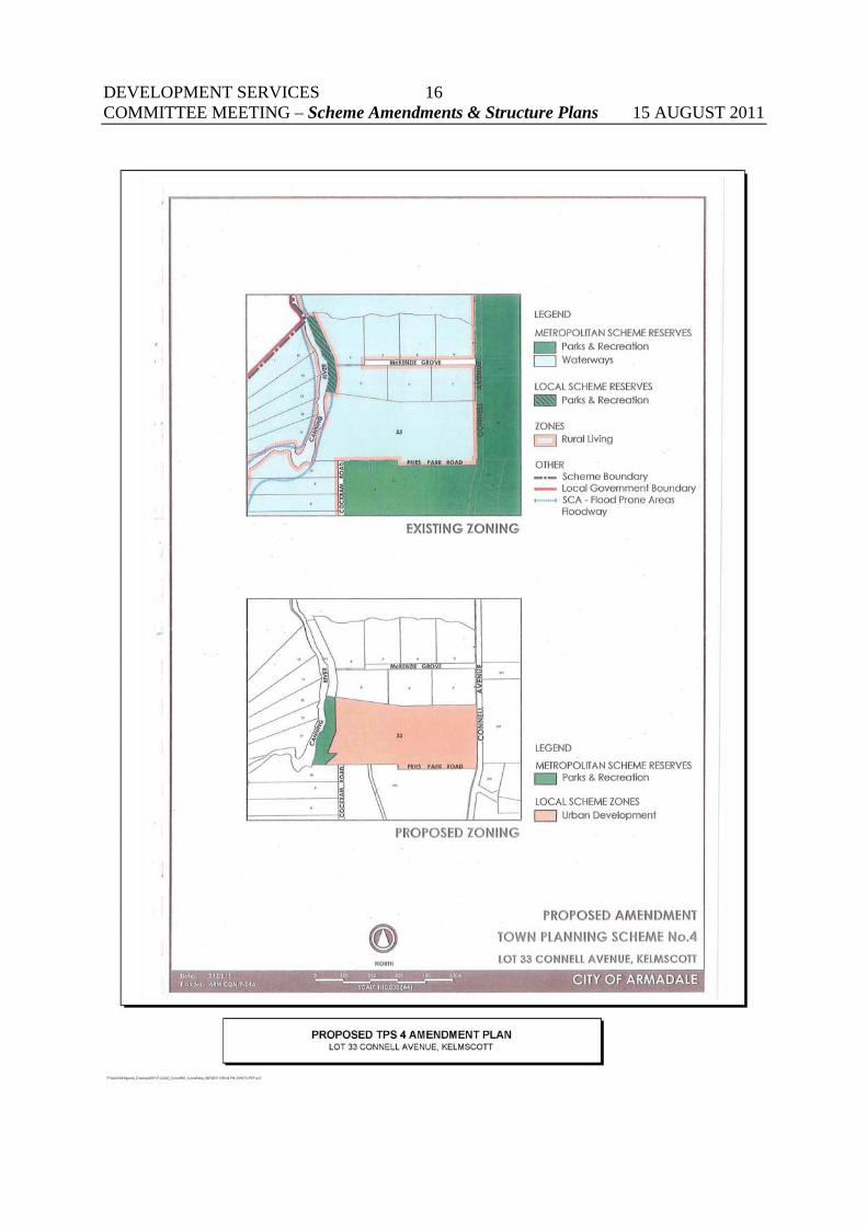
BACKGROUND The Site Lot 33 Connell Avenue is a 13 hectare parcel of land owned by the City of Armadale and is known as Pries Park. Lot 33 is zoned Rural under the Metropolitan Region Scheme and Rural Living 2 under the City’s Town Planning Scheme No.4. Rural Living 2 has a minimum lot size requirement of 2 ha so the 13ha site has potential under the current zoning for subdivision into up to 6 Rural Living lots. The site is located in an attractive setting between the Canning River and the abundant bushland reserves of the Darling Ranges. The site also has reasonable proximity to the Kelmscott urban town centre and public transport links. These attributes provide an opportunity for a highly liveable residential estate which could be anticipated to be highly sought after by new homebuyers. Currently the site is used for soccer (two pitches) and pony club activities. Basic club and change room facilities are also located on the site. A review of the City’s active sporting reserves has been undertaken resulting in the Needs Study Final Report December 2008 (A Balanced View Leisure Consultancy Services). This review found drainage problems on the eastern side of pitches from the steep embankment, some evidence of weed infestation of the turf, inadequate parking and the pavilion being in need of maintenance. The report consequently found that Pries Park had limited use as a sporting facility and should be considered for rationalisation. If rezoned for urban residential development there would be potential to subdivide into a range of approximately 150-180 residential lots with lot sizes between 250m² and 800m², which are currently being produced by most developers in similarly well located areas.

DEVELOPMENT SERVICES COMMITTEE MEETING – Scheme Amendments & Structure Plans 15 AUGUST 2011
12DEVELOPMENT SERVICES COMMITTEE MEETING – Scheme Amendments & Structure Plans 15 AUGUST 2011
12

DEVELOPMENT SERVICES COMMITTEE MEETING – Scheme Amendments & Structure Plans 15 AUGUST 2011
13
Previous Council resolutions The City is facing significantly increased demand for sporting facilities in the southern and western parts of the City (Wungong Urban Water area and the North Forrestdale area). Consequently, the City commissioned consultants to prepare an assessment and feasibility study for active sporting reserve needs in the City. The 2008 Active Sporting Reserves Needs Assessment and Feasibility Study recommended a strategy to upgrade nominated existing grounds, promote joint use with schools and support the staged development of a regional active sporting reserve located between Waterworks Road and Twelfth Road, Haynes. This report also recommended that Lot 33 Connell Avenue be disposed of with part of the proceeds to be used to assist with the upgrading of active sporting reserves and the proposed provision of new active reserves. In November 2008 the Council resolved to prepare a planning study for Lot 33 Connell Avenue to investigate the potential for residential development on the land, including investigation of possible inclusion of directly abutting private lots to the north (refer CS115/11/08. Furthermore, Council agreed to call for tenders for the engagement of a suitably qualified consultant team to undertake the environmental and servicing studies required by state agencies to facilitate land use change to residential development. Council’s resolution in this regard was as follows: CS115/11/08 That Council: 1. endorse the preparation of a planning study for the Connell Avenue Precinct (including
Pries Park and Kelmscott Pony Club) to investigate potential for urban residential development on the land, including investigation of possible inclusion of directly abutting private lots to the north.
2. call for Tenders for the engagement of a suitably qualified consultant team to undertake
the environmental and servicing studies required by state agencies to facilitate land use change to urban residential development.
3. following appointment of a consultant, call a meeting of stakeholders and affected
community members to advise on the options and plans for Pries Park and the reasons behind Council’s decision.
A Tender was advertised for the provision of Planning Consultancy Services with regard to Lot 33 Connell Avenue in January 2009. Council resolved to award the tender to Burgess Design on 22 March 2009.

DEVELOPMENT SERVICES COMMITTEE MEETING – Scheme Amendments & Structure Plans 15 AUGUST 2011
14

DEVELOPMENT SERVICES COMMITTEE MEETING – Scheme Amendments & Structure Plans 15 AUGUST 2011
15
DETAILS OF PROPOSAL Objective of Study The objective of the project is to undertake sufficient investigations in support of a submission to the WAPC to satisfy the requirements to initiate an amendment to the MRS to rezone Lot 33 Connell Avenue, Kelmscott, and adjacent land from Rural to Urban (and associated reservations) and provide a structure plan for the land. Tasks required to be undertaken by Burgess Design 1. Undertake detailed site investigation and assessment
2. Undertake specific studies relating to constraints pertaining to the land – including vegetation, conservation, aboriginal sites, and geological suitability.
3. Liaise with relevant State Government agencies – including EPA and DEC, DPI, Swan River Trust and Indigenous Affairs.
4. Undertake assessment of servicing requirements for the land. Liaise with relevant agencies relating to water, drainage, water management (including any necessary water management strategy), sewerage, power and education services.
5. Undertake briefing/s of stakeholders in locality relating to the expected process and outcomes and undertake community consultation as appropriate.
6. Liaise with landowners of nearby properties with a view to establishing potential for inclusion within a joint rezoning proposal.
7. Prepare documents suitable for submission to WAPC on rezoning proposal including:
a) associated amendment/s to MRS/Town Planning Scheme.
b) supporting documentation for environmental approval.
8. Comment on result submissions to MRS/Town Planning Scheme Amendments.
9. Undertake necessary Aboriginal Sites investigation and clearance.
10. Prepare draft structure plan for proposal providing indicative subdivision design and provision of open space and services.
11. Recommend upon appropriate developer contribution arrangements
12. Prepare final structure plan following review of submissions. Items 1 to 7 inclusive have now been delivered by Burgess Design. Accordingly, the Council may now proceed to the stage of submitting a request to the Western Australian Planning Commission (WAPC) that they initiate an amendment to the MRS.
DEVELOPMENT SERVICES COMMITTEE MEETING – Scheme Amendments & Structure Plans 15 AUGUST 2011
16

DEVELOPMENT SERVICES COMMITTEE MEETING – Scheme Amendments & Structure Plans 15 AUGUST 2011
17
COMMENT Development Control Unit (DCU) The proposal was referred to the DCU and no objection to the rezoning was raised. However some matters were raised that may require further investigation prior to the structure plan component of the project being adopted by the Council. These matters include: • Fire and Emergency Management
A fire management plan being prepared prior to finalisation of the structure plan to determine relevant provisions for the Structure Plan. Lot 33 is adjacent to the Banyowla Regional Park and the Canning River Foreshore Reserve and slopes up steeply from the Canning River to Connell Avenue. This means the fire risk in the wider locality is extreme and a site specific assessment should be undertaken. Likely provisions would include the requirement for dwellings to be built to the Australian Standard 3959 Buildings in Bushfire Prone Areas. Design considerations would most likely include the extension of Cockram Street into Lot 33 to provide an alternate route into and out of the development other than just Connell Avenue.
• Environment
The extent of and use of any buffers for wetlands and remnant vegetation areas on or adjacent to Lot 33 needs to be considered in the final structure plan.
The location of the east/west running path indicated on the SP should be considered in line with the statement on page 31 of the SP document which reads “Integration of the public open space with regional open space/foreshore reservation as to reduce the active use of the conservation areas and directing the active use back towards the cleared areas of public open space.” In order to fulfil this statement, the footpath should rather than direct people straight to the regional park and river foreshore, link through/across the northern POS area to enable people to utilise this area for active recreation.
The interface between the R25 area and the Bush Forever area should allow for a road network buffer as in the remainder of the SP.
• Technical Services
Technical Services provided the following comments: a) There should be a path on all streets; b) Pries Park Road seems to extend further west than is necessary to service all of the
lots; and c) There is one section of internal 50m road reserve which results in construction of
approximately 50m of road which does not seem to be necessary. Access to these lots could be served just as well direct from Pries Park Road.
All of the above matters can be addressed through the final structure plan and do not impact on the MRS amendment. Advertising of the MRS amendment will assist in identifying the issues that need to be resolved in the more detailed levels of planning and assessment.
DEVELOPMENT SERVICES COMMITTEE MEETING – Scheme Amendments & Structure Plans 15 AUGUST 2011
18

DEVELOPMENT SERVICES COMMITTEE MEETING – Scheme Amendments & Structure Plans 15 AUGUST 2011
19
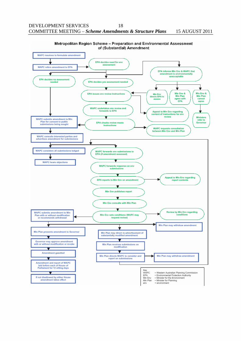
ANALYSIS Consultation with Stakeholders The first action undertaken by the Planning Consultants was to meet and liaise with potential stakeholders. This included the Kelmscott Pony Club and Kelmscott Soccer Club and landowners within McKenzie Grove adjacent to the northern boundary of Lot 33. In preparation for the likelihood that Council may decide to proceed with the sale of Pries Park, contact was initiated with the Kelmscott Pony Club to discuss the future of the Club including options for relocation or possible amalgamation with another equestrian group. The Club has been advised that it is likely that the land would be unavailable for use as an equestrian facility and that the City would work with them to identify and consider alternative venue options. In the meetings and discussions that were held with the club it became evident that in order to properly identify the options available to the club, a separate study was required that would consider the needs of all the equestrian clubs operating in the City, and options for meeting those needs. The Council subsequently commissioned an Equestrian Needs Study to assess the needs of each of the three horse and pony clubs operating within the City. The draft study was received by the Council in March 2010 (refer C5/3/10) and Council resolved to invite public comment on the document. Following close of the public comment period, the final report was received by Council in June 2010. Consulting firm A Balanced View Leisure Consultants were contracted to undertake the Study which included extensive consultation with the local equestrian clubs and other interested members of the community. Through a thorough research and consultative process, it was determined that the best option for the Kelmscott Pony Club was to co-locate with other clubs at Palomino Reserve. Metropolitan Region Scheme and Local Planning Scheme Amendments The Western Australian Planning Commission (WAPC) is responsible for keeping the Metropolitan Region Scheme under review and initiating changes where they are seen as necessary. The Metropolitan Region Scheme (MRS) sets out the broad pattern of land use for the whole Perth metropolitan region. The MRS is constantly under review to best reflect regional planning and development needs. An amendment proposal to change land use reservations and zones in the MRS is regulated by the Planning and Development Act 2005. That legislation provides for public submissions to be made on proposed amendments. For a substantial amendment, often referred to as a major amendment (made under section 41 of the Act), the WAPC considers all the submissions lodged, and publishes its recommendations in a report on submissions. This report is presented to the Minister for Planning and to the Governor for approval. Both Houses of Parliament must then scrutinise the amendment before it can take legal effect.

DEVELOPMENT SERVICES COMMITTEE MEETING – Scheme Amendments & Structure Plans 15 AUGUST 2011
20
The full process for a MRS amendment is set out in the flow chart as referred to in this report. The Environmental Protection Authority must consider the environmental impact of an amendment to the MRS before it can be advertised. Should it require formal assessment, an environmental review is undertaken and made available for information and comment at the same time as the amendment report. Concurrent Local Scheme Amendment It is anticipated that a concurrent amendment process for joint MRS/TPS amendments could be used to put in place an Urban Development zone under TPS No.4 (the Urban Development zone requires a Structure Plan to be prepared and adopted prior to subdivision and development being approved). Section 126(3) of the Planning and Development Act (2005) allows a local government to request the WAPC to amend a local planning scheme concurrently with a region scheme, where the region scheme amendment proposes to rezone land for urban purposes, as is the case with Lot 33 Connell Avenue. Upon rezoning under the Metropolitan Region Scheme, and concurrent rezoning to ‘Urban Development’ under the City of Armadale Local Planning Scheme No.4, the provisions of the MRS and LPS will apply, including that a Structure Plan be prepared, advertised and implemented prior to subdivision as a means of guiding the subsequent subdivision and development of the site in a well planned manner. Refer to MRS and LPS Amendment Plans included in this report. Whilst the Structure Plan process is separate and subsequent to the rezoning, a Development Concept Plan has been prepared and included in the MRS and Local Scheme Amendment report to provide an indication of the form in which the urban development may result. The key features of this Development Concept Plan include: • 58 lots at an R20 density; • 17 lots at an R25 density; • 71 lots at an R30 density; • 43 lots at an R40 density; • Total 189 lots; • 2 areas of Public Open Space (equating to 10%+ of the site); • An area of Regional Open Space (river foreshore) which is also a Bush Forever site; and • An integrated road network which connects with the existing Pries Park Road and Connell
Avenue and provides for an appropriate interface with land to the north. Refer to Development Concept Plan included in this report. It should be noted that neither the MRS Amendment nor the proposed concurrent LPS Amendment will specify density or intensity of land uses. The Concept Plan is only included at this stage to provide an indication of the land use and infrastructure allocation to be addressed as part of the more detailed structure planning at the final statutory structure plan and subsequent levels of planning.

DEVELOPMENT SERVICES COMMITTEE MEETING – Scheme Amendments & Structure Plans 15 AUGUST 2011
21

DEVELOPMENT SERVICES COMMITTEE MEETING – Scheme Amendments & Structure Plans 15 AUGUST 2011
22DEVELOPMENT SERVICES COMMITTEE MEETING – Scheme Amendments & Structure Plans 15 AUGUST 2011
22

DEVELOPMENT SERVICES COMMITTEE MEETING – Scheme Amendments & Structure Plans 15 AUGUST 2011
23

DEVELOPMENT SERVICES COMMITTEE MEETING – Scheme Amendments & Structure Plans 15 AUGUST 2011
24
Planning Investigations Outcomes The following reports have been prepared by the Consultants and submitted to the City: • Metropolitan Region Scheme and Local Planning Scheme Amendment Report; • Structure Plan Report; The above reports have been informed by the following technical investigations: • Engineering Servicing Report • Aboriginal and Cultural Heritage Report • Environmental Report Engineering Servicing Report The Engineering Consultant determined that Lot 33 is capable of being serviced with all essential services and has no identifiable problematic soil conditions based on preliminary assessment of the site. The following servicing information and preliminary servicing costs were provided in the Engineering Services report: Gas Supply • There is an 80mm medium pressure gas main along Connell Ave that terminates
approximately 25m from the southern boundary of Lot 33. • The existing main will be capable of servicing approximately 160 dwellings. • No capital contribution will be required if the development is serviced from this existing
main via Pries Park Road. • Extension of the existing gas main along Connell Avenue is not expected to be required.
However if it is required a capital contribution (currently $140 per metre including trenching) will need to be paid by the developer.
Telecommunications • There is a service network in the vicinity of the proposed development from which limited
service is available. • The network should be able to be upgraded to suit the development with
Telecommunication services without a capital contribution. • Telstra will install any new telecommunication network facilities, subject to the developer
providing trenching for laying of ducts. • A formal application has been made to Telstra through the Telstra Smart Community
service. • No headwork charges for Telstra services are anticipated.
Western Power • There is a service network within the study area and should have sufficient capacity to
service the development with underground power connected from the existing overhead/underground systems located near to Lot 33.
• All electricity infrastructure, servicing and supply costs are the responsibility of the developer.
DEVELOPMENT SERVICES COMMITTEE MEETING – Scheme Amendments & Structure Plans 15 AUGUST 2011
25
Sewer Reticulation • Lot 33 is outside Water Corporation’s (WC) current planning. A formal letter of interest in
developing this parcel of land needs to be sent to WC by the Council, before WC would be prepared to make arrangements to service the site with sewer.
• Sewer infrastructure would comprise conventional gravity sewer system of reticulation sewers located within road reserves and connected to Water Corporation’s network by a new pump station within the development.
• The size and cost estimate of a pump station would be provided by WC once they have a formal letter of interest from the Council/developer.
• Standard WC headwork charges will apply this to development along with the construction of infrastructure to connect to the WC sewerage system.
Water Reticulation • Lot 33 is outside Water Corporation’s (WC) current planning. • A 1370 diameter steel trunk distribution main runs along Connell Ave but would not be
available to service the subdivision. • Extension of existing water main infrastructure located 500m south of the site would be
required at the developer’s expense. • Standard WC water headwork charges will apply. Roads A new subdivisional road running east-west through the site is proposed to provide the main ingress/egress point from the proposed residential area onto Connell Avenue. The current intersection of Connell Avenue and Pries Park Road has constrained sight lines due to the topography near this point and may require speed and intersection treatment to remove any dangerous points. However, traffic volumes at this intersection will be considerable lower than the proposed Connell Avenue intersection. Lot 33 also has frontage to the Cockram Road reserve although this road is not constructed through to Lot 33. It is desirable that the road design include provision for the connection of Cockram Road through to the new residential area for several reasons including, providing an alternative route into and out of the estate in times of emergency (eg. bush fire threats) and providing an alternative safe access to and from the estate as an alternative to the two (existing and proposed) intersections onto Connell Ave. Connell Avenue is a District Distributor B road with potentially high traffic volumes, topographical constraints on traffic safety and high speeds (70kmh). A traffic assessment will be undertaken prior to completion of the structure plan to ensure the development provides the best possible level of traffic safety and ease of traffic movement.

DEVELOPMENT SERVICES COMMITTEE MEETING – Scheme Amendments & Structure Plans 15 AUGUST 2011
26
Earthworks The Canning River Flood Study shows that lot 33 is affected marginally by flooding during major river flows with the 100 year ARI flood level estimated to be 15.17 m AHD. The flood way affects a small part of the extreme western area of Lot 33 and will be wholly within proposed Parks and Recreation reserves. Therefore filling of Lot 33 will not be required as a result of the flood way. However, site levels will need to achieve the following outcomes: • Geotechnical and soil parameters set to ensure that the site achieves a minimum
Classification of “S” (Slightly Reactive). • Finished pad levels to conform to the regional drainage requirements as identified in the
published urban stormwater drainage strategies consistent with recent government initiatives for the area.
The Engineering Services report advises that it is expected that approximately 0.5m of fill will be required across the site to achieve the above outcomes. This is relatively minor compared to the high levels of fill required in other newly developing urban areas within the City ,such as Harrisdale and Piara Waters where approximately 1.2m of fill is required to provide adequate separation from groundwater levels and to allow for urban drainage. Drainage A concept Stormwater Master Plan / Stormwater Management Plan has been prepared for Lot 33 and a set of design criteria have been established based on current best practice stormwater management. The primary aim for stormwater management within the subdivision is for minimised collection, and on-site retention and infiltration of both stormwater and entrained contaminants. It features use of on-site retention and infiltration of stormwater and an on-site retention basin in the POS with overflow to natural drainage features to limit the impact of the development. Aboriginal and Cultural Heritage An ethnographic consultation was conducted by the heritage consultant with Aboriginal Consultants from the CSR&SCP Native Title Working Group, Ballaruks People and the Collard and Hansen Families. The Aboriginal Consultants identified no new ethnographic sites within Lot 33. They did however reaffirm the significance of the Swan and Canning Rivers, commented on the PDA and the proposal. The main comments and requests made by the Aboriginal Consultants were: 1. The CSR&SCP Consultants indicated that a pathway near or leading to the river would
require a separate consultation. 2. The CSR&SCP Consultants requested a heritage agreement be established between the
City of Armadale and the Aboriginal Consultants. 3. The CSR&SCP Consultants requested a meeting with the City of Armadale “bosses” to
establish the heritage agreement, establish an appropriate buffer by the river in which no disturbance will occur and to obtain further details regarding this proposal.
4. The CSR&SCP Consultants requested that the vegetation by the river be incorporated into Banyowla Park adjacent to the PDA.

DEVELOPMENT SERVICES COMMITTEE MEETING – Scheme Amendments & Structure Plans 15 AUGUST 2011
27
5. The CSR&SCP Consultants objected to any disturbance and clearing occur close to the
river, including the proposed Public Open Space. 6. All groups requested that as much as possible native vegetation be retained. 7. All groups requested that revegetation consist of native species An archaeological site identification survey of the proposed development area was also conducted by the heritage consultant. No archaeological material or sites were identified within the proposed development area. The area has been disturbed as a result of extensive quarrying of the site prior to its development and use as a local parkland, sporting venue and horse riding club. It is considered by the consultants that the probability of sub-surface material in the Pries Park (soccer fields and pony club) area of the site is low to negligible due to the high level of prior disturbance and low to moderate in the Canning River boundary area for the same reasons. Due to the history of freehold title, Lot 33 is not subject to the Native Title Act 1993. The heritage consultants made the following recommendations: 1. The proposed works will impact upon DIA 3536 Swan River and DIA 3538 Canning
River. Therefore, a Section 18 application will be required to avoid a breach of Section 17 in accordance with the City of Armadale’s responsibilities under the Aboriginal Heritage Act (1972).
2. The City of Armadale considers the requests raised by the Aboriginal Consultants. 3. The City of Armadale adopts a Cultural Material Contingency Plan. 4. In the interests of procedural fairness, the Aboriginal Consultants are provided with a
copy of the Section 18 application prior to submission by the City of Armadale. 5. In the interests of procedural fairness, the Aboriginal Consultants are advised of the
Section 18 application outcome and any conditions attached thereto. 6. All City of Armadale staff and contracting personnel are made fully aware of their
obligations under the Aboriginal Heritage Act (1972). Further consideration can be given to the heritage consultant’s recommendation as part of advertising and formal final adoption of the structure plan. A Section 18 clearance under the Aboriginal Heritage Act will be required prior to commencement of subdivisional works. However, given the consultation and study has not identified any major issues the Section 18 clearance process is relatively straight forward. Environmental Considerations An environmental opportunities and constraints assessment was carried out for Lot 33. The findings of that assessment are summarised below: Flora and Vegetation • Some remnant native vegetation in the westernmost area of the site, particularly along the
banks of the Canning River. • No known recorded occurrences of DRF, priority flora or TECs occurring on the site but,
a number of DRF, priority flora and TECs are located in close proximity to the site associated with the banks of the Canning River.
• Bush Forever site (Canning River foreshore) within extreme western portion of the site.

DEVELOPMENT SERVICES COMMITTEE MEETING – Scheme Amendments & Structure Plans 15 AUGUST 2011
28
Fauna • The remnant area of vegetation in the western portion of the site may support or provide
habitat for some fauna species. More detailed fauna surveys would only be required if it was proposed to clear the area of remnant vegetation. This is unlikely as the vegetation is contained within a Bush Forever site and is affected by the Canning River flood way.
Wetlands • A Conservation Category wetland (CCW) covers part of the western area of the site
(Canning River) and another palus plain CCW is located adjacent to the southern boundary of the site within the Banyowla Regional Park. Both wetlands are considered to have significant conservation values and development needs to protect and consider these as more detailed planning proceeds.
Drainage • The requirements of the Western Australian Planning Commission’s (WAPC) Liveable
Neighbourhoods and the Department of Water’s Stormwater Management Manual for Western Australia will apply to the consideration of drainage design of the site.
• There are no obvious existing surface drainage features such as stormwater drains or pipes existing on site and following rain periods the playing fields have patches of shallow standing water. Existing and natural surface water flows are towards the Canning River which is the main drainage feature of the locality.
Acid Sulphate Soils • Part of the site has been classified as having a high risk of Acid Sulphate Soils (ASS)
occurrence. This is within the area of Lot 33 that contains the Canning River and its foreshore. Although an ASS investigation will be required as part of any subdivision it is unlikely that any ground disturbance will be proposed within the area classified as high risk due to its location.
Contamination • The prior quarry operations carried out on the site in the 1950’s and 60’s are considered
potentially contaminating activities by the DEC. • It is likely the DEC will require at least a Preliminary Site Investigation (PSI) to define
and assess potential contamination at the site. A PSI generally includes a more detailed assessment of historical activities with the intent of investigating the need for soil or groundwater sampling. If this is required the PSI carried out prior to site disturbance (subdivision) will provide information on the sampling and analysis program required meet DEC standards with respect to potentially contaminated sites.
Conclusion There are some environmental issues in relation to the site. However, theses will be subject to further investigations and consultation with the relevant agencies as part of detailed planning for the site. With best practice environmental planning the environmental aspects of the site are considered manageable based on current information. Timely consideration should be given to gaining environmental approvals.

DEVELOPMENT SERVICES COMMITTEE MEETING – Scheme Amendments & Structure Plans 15 AUGUST 2011
29
Compliance with Strategic Planning Objectives for the Perth Metropolitan Area and Kelmscott District There are a number of strategic planning documents for both the Perth Metropolitan Area and locally for the Kelmscott District that support the proposed rezoning of Lot 33 to Urban under the MRS. These include: Directions 2031 for the Perth Metropolitan Region (WAPC) State Planning Policy 4.2 Activity Centres for Perth and Peel (WAPC) Kelmscott Enquiry by Design Outcomes (COA) The main objectives of Directions 2031 are: • Promoting higher densities; • Increasing catchment populations close to activity centres; • Improving public transport patronage; • Promoting community connectivity and health particularly through the walk trails
strategy; • Protect biodiversity and environmental significance; • Expand and enhance open space networks through continued identification and
management; and, • Maximise urban infrastructure to improve efficiency of existing services. In this regard, Lot 33 Connell Avenue is in an area which is in close proximity to an existing urban area where normal urban infrastructure, public open space, dual use paths and walk trails already exist. The site is also less than 2 kilometres from major regional highways connecting back to several employment centres and situated between two metropolitan train stations. In addition, the intensification of residential development in the area within the catchment of the Kelmscott District Centre is consistent with objectives of Directions 2031, SPP 4.2 and the Kelmscott Enquiry By Design Workshop, which promotes increasing the local population to support the development of the Kelmscott Town Centre as a true Town Centre. State Planning Policy 3.4 Natural Hazards and Disasters (SPP 3.4) SPP 3.4 requires careful consideration to be given to natural elements that may combine to create hazards in development areas such as: • Climate • Geology • Soils • Vegetation cover • Slopes • Landforms • Hydrology.

DEVELOPMENT SERVICES COMMITTEE MEETING – Scheme Amendments & Structure Plans 15 AUGUST 2011
30
Other factors that need to be taken into account when planning for new development areas include: • The built environment • Community awareness • The history of hazard events in the region • The potential for long-term changes to risk such as climate and land use change. Considering all of these elements will enable the definition of natural hazard management areas in planning strategies and schemes. The main natural hazards that need to be taken into consideration with regard to the planning and development of Lot 33 are: • Flood • Bush Fires • Landslides Flood A small portion of Lot 33 is within a floodway for the Canning River. However, as previously stated, this area is within the portion of Lot 33 that will be reserved for Parks and Recreation under the MRS and as such is outside the development area. Historical data for ground water levels across the site will need to be analysed to determine desirable finished ground and floor levels. The development areas identified on the Concept Plan attached to this report are at a considerably higher level than the flood prone area of the site and as such it is expected that minimal fill (approximately 0.5m) will be required. The main issue will be the disposal of stormwater runoff as the existing playing fields appear to lack any drainage at present and are subject to standing water on the fields after rain periods. An Urban Water Management Strategy and Plan will be prepared to manage water quality and quantity generated by the development. Bush fires The Banyowla Regional Park and the Canning River foreshore area abutting and surrounding the subject site are identified as having an Extreme risk for bush fires. A significant bush fire occurred in the Banyowla Regional Park in 2008/2009, burning up to the boundaries of Lot 33 and coming within metres of a house on a McKenzie Grove property on the north side of Lot 33. The February 2011 bushfire that affected Kelmscott and Roleystone and resulted in the loss of more than 70 houses and other structures is an extreme reminder of the importance of fire management being used to inform the structure of any future urban area within proximity to or containing fire hazards. Earlier this year residents of Ciro Place and Cockram Road adjacent to Lot 33 presented a petition to the Council requesting bush fire management measures relating to the Banyowla Regional Park and in particular, requesting the provision of an alternative road/escape route out of their streets. This is consistent with the recommendation included in this report that Cockram Road be extended to provide an alternative route into and out of Lot 33.

DEVELOPMENT SERVICES COMMITTEE MEETING – Scheme Amendments & Structure Plans 15 AUGUST 2011
31
The preliminary planning costs budget includes an item for the preparation of a fire management plan (FMP). This will include an assessment of the risk, management measures and implementation. It is intended that preparation of this plan be initiated in the near future so that any changes required to the structure plan as a result of the outcomes of the FMP are implemented in the final plan and as early as possible. Items that will need to be addressed include: • The provision of adequate low fuel separation zones between housing lots and remnant
bushland areas; • The provision of alternate routes into and out of the residential area such as extending
Cockram Road into the western part of Lot 33 as an alternative to the proposed and existing access points onto Connell Avenue.
• The inclusion of provisions on the structure plan requiring the construction of dwellings to be in accordance with Australian Standard 3959 Buildings in Bushfire Prone Areas;
• The inclusion of provisions relating to landscaping being restricted to vegetation that has low flammability, fire retardant/protection properties in proximity to residences; and
• The layout of the final Structure Plan land use and infrastructure layout. The timing of finalisation of the FMP will need to enable inclusion of any recommendations coming out of the State Government enquiry into the Roleystone/Kelmscott fire event. Landslides and other land movements Lot 33 has 2 levelled areas containing the old playing fields and a gently sloping area in the western portion of the site. However, in between Connell Avenue and the first playing field and between the two playing fields there are quite steep sand banks. Accordingly, a geotechnical investigation will be required to determine whether specific measures are required with regard to the construction of buildings, the impact of construction of infrastructure across slopes that may increase the possibility of land moving and any additional measures that may be required in order to mitigate against landslides. Planning Process It is realistically expected that the MRS Amendment will take approximately 2 years to complete, assuming the EPA does not require a formal assessment or environmental review prior to the commencement of advertising of the amendment. The WAPC may agree to amending TPS 4 automatically concurrently with the MRS amendment in accordance with S.126 of the Planning and Development Act. However, if a concurrent amendment can not be achieved it would be appropriate for the City to initiate the amendment to TPS 4 and initial adoption of the structure plan once the WAPC has received consent from the Minister for Planning to advertise the MRS Amendment. In this instance the TPS 4 amendment and structure plan processes would run concurrently and be advertised at the same time, although separately to the MRS amendment process. While a draft Structure Plan report has been prepared it is primarily for information at this stage and a number of minor corrections and clarifications will be made. The MRS and TPS amendment and the adoption of the structure plan could occur around the same time, or if detailed planning requires extra time to resolve specific unforeseen issues, the TPS Amendment or Structure Plan can be deferred pending the completion of any studies required.
DEVELOPMENT SERVICES COMMITTEE MEETING – Scheme Amendments & Structure Plans 15 AUGUST 2011
32
OPTIONS 1. Council may resolve to request the Western Australian Planning Commission initiate an
amendment to the Metropolitan Region Scheme to rezone Lot 33 Connell Avenue Kelmscott from Rural to Urban and Parks and Recreation – Regional and concurrently amend TPS No.4.
2. Council may resolve not to request the Western Australian Planning Commission
initiate an amendment to the Metropolitan Region Scheme. CONCLUSION The proposed rezoning under the MRS and TPS is intended to provide for an expansion of the residential suburb of Kelmscott in a well planned manner with the aim being to ultimately create an estate to cater for the growing population and housing needs in the City and support the Kelmscott District Activity Centre and urban rail-bus interchange infrastructure. The intensification of land use by means of Urban zoning would be consistent with the outcomes and recommendations of the Kelmscott Enquiry By Design Workshop which promotes increasing the local population to support the development of the Kelmscott Town Centre as a true Town Centre such that it is able to offer diverse economic and social opportunities to the surrounding communities. The westward projection of the Darling Range Regional Park (Parks and Recreation Reservation MRS) delineates the site from the existing residential lots further south such that it would offer opportunities for marketing of a distinct new future urban development node with distinctive lifestyle benefits. The disposal of Lot 33 and its subsequent conversion to urban development (whilst still including the required 10% public open space) will generate funds which will be able to be allocated to the development and acquisition of parks elsewhere in areas of the city that have, or will in future have, a shortfall of suitable active open space facilities. Plans, engineering and environmental investigation has determined that the site is capable of being serviced with all essential services, has no identifiable problematic soil conditions based on preliminary inspection of the site and with careful considered design would result in a high quality development. It is considered that the planning process and more detailed studies and environmental and servicing assessments entailed will be able to address the identified issues to produce a high quality residential environment. Option 1 is accordingly recommended.

DEVELOPMENT SERVICES COMMITTEE MEETING – Scheme Amendments & Structure Plans 15 AUGUST 2011
33
RECOMMEND
That Council:
1. Receive the consultants’ reports (Structure Plan and,
Metropolitan Region Scheme and City of Armadale Local Planning Scheme No.4 Amendments) for Lot 33 Connell Avenue, Kelmscott.
2. Refer the Metropolitan Region Scheme and City of Armadale
Local Planning Scheme No.4 - Lot 33 Connell Avenue, Kelmscott report to the Western Australian Planning Commission (WAPC) requesting that the proposed rezoning of the land to Urban zone and reservation for Parks and Recreation as depicted in the draft scheme amendment plans, be included in a forthcoming amendment to the Metropolitan Region Scheme, so that it may be advertised for public review and submissions. Submission to WAPC to include request for concurrent amendment of Town Planning Scheme No.4 as provided for under Section 126 of the Planning and Development Act 2005.
3. Require the Consultant to amend the structure plan to address the
following issues to the specification and satisfaction of the Executive Director Development Services:
• Construction of Cockram Road through to new road within
Lot 33 Connell Avenue; • Corrections and clarifications to the structure plan report. • Any design requirements and provisions determined as
necessary following completion of a fire management report for the development;
• Any design requirements determined as necessary following completion of a traffic impact assessment; and
• Any design requirements determined as necessary following completion of a hydrological assessment of the site.
4. Notify all stakeholders and adjacent landowners of this resolution
and the recommendation that the Western Australian Planning Commission proceed with a statutory amendment to the Metropolitan Region Scheme.
Moved Cr _______________ Carried/Lost ( )

DEVELOPMENT SERVICES COMMITTEE MEETING – Scheme Amendments & Structure Plans 15 AUGUST 2011
34
PROPOSED INITIATION OF TEXT AMENDMENT NO.63 TO TOWN PLANNING SCHEME NO.4 & REVIEW OF PLANNING POLICY 2.2- REFLECTIVE MATERIAL ON RESIDENCES WARD
: ALL
DATE
: 14 July 2011
REF
: GW
RESPONSIBLE MANAGER
: EDDS
APPLICANT
: City of Armadale
Tabled Items Nil.
In Brief:
Council at its meeting on 24 January 2011 requested officers review Clause 5.9 of TPS No.4 and PLN 2.2.
The proposal involves deletion of the reflective material provision (Clause 5.9) from TPS No.4 and inserting a new clause to prohibit the use of zincalume in the Special Residential zone only.
Recommend that Council initiate Amendment No.63 and revoke PLN 2.2- Reflective Material on Residences.
Officer Interest Declaration Nil. Strategic Implications 2.1 Long term planning and development that is guided by a balance between economic,
social and environmental objectives 2.3 Diverse and attractive development that is integrated with the distinctive character of the
City. 2.4 Attractive and user-friendly streetscape and open spaces. Legislation Implications Planning and Development Act 2005 Town Planning Regulations 1967 Metropolitan Region Scheme Town Planning Scheme No.4 Council Policy / Local Law Implications Local Planning Strategy 2005 PLN 2.2 Use of Reflective Materials on Residences Budget / Financial Implications Nil.

DEVELOPMENT SERVICES COMMITTEE MEETING – Scheme Amendments & Structure Plans 15 AUGUST 2011
35
Consultation
Development Control Unit.
If initiated, the scheme amendment will undergo a process of advertising for public submissions in-accordance with the requirements of the Town Planning Regulations 1967.
BACKGROUND Council at its meeting on 24 January 2011, resolved to support the future review of Clause 5.9 of TPS No.4 and PLN 2.2. (D6/1/11). The report presented to Council on 24 January 2011 noted the review “needs to focus on the extent to which amenity is compromised by glare from light colours and how the offending surfaces can be determined in a statutory sense. The options to progress the matter could include the following:
Identify a wider suite of unacceptable colours and materials.
Revert to the solar absorptance figures which would accommodate new colours as they come on the market – by restricting surfaces to those with a value of, say, 0.5 (i.e. the BCA’s definition of “dark”).
Accept lighter colours provided a coating is provided to the colour to reduce the
reflectivity. (Bluescope Steel has indicated that no such material exists and that other than comprehensively painting a surface they cannot recommend any technique for the reduction of reflectivity).
Dispense with the control on colours and adopt a more site specific approach involving
design controls to require certain roof pitch, limitation of the extent of similar angled sheeting, or the requirement for landscaping or site specific techniques.”
Further to the above, Council recently at its meeting on 27 June 2011 approved a reflective roof (“Surfmist”) at Lot 115 Brooks Rd, Roleystone and noted the following:
The majority view of the meeting was that Council support the recommendation. Committee discussed a number of issues regarding reflective roofs and was of the opinion that high reflectivity can be found to occur regardless of colour. The majority of colorbond roof colours have a similar gloss level and would give a similar mirrored reflection and changing from lighter to darker colours may not considerably reduce the perceived glare.

DEVELOPMENT SERVICES COMMITTEE MEETING – Scheme Amendments & Structure Plans 15 AUGUST 2011
36
Planning officers have previously expressed the view to Council that Scheme Clause 5.9 should be deleted and the policy be revoked. This view has arisen due to the difficulty in adjudication over reflectivity which is regarded as subjective. Other issues supporting this stance are outlined further in this report below. DETAILS OF PROPOSAL The proposal involves initiation of text amendments to Town Planning Scheme No.4 by: 1. Deleting Clause 5.9 relating to the use of Reflective Materials; 2. Inserting a new Clause 5A.3 to prohibit the use of zincalume as an exterior finish on any
building or structure within the Special Residential zone. In addition, as a consequence of the abovementioned text amendments it is also proposed to revoke PLN 2.2- Use of Reflective Materials on Residences. COMMENT Background to Clause 5.9 and PLN 2.2 The City currently controls the use of reflective materials through Clause 5.9 of Town planning Scheme No.4 which restricts the use of reflective building materials in those areas east of the Albany and South West Highways. The current controls were modified from the controls under Town Planning Scheme No.2 that required Council approval for the use of building material that were “highly reflective or likely to cause glare” When reviewing the provisions in 2003 it was proposed that greater clarity in interpretation would be provided by defining unacceptable reflective materials as those with an absorptance value of less than 0.6. In addition it was proposed that general controls should be strengthened to prevent the construction of reflective roofs over the whole City. Accordingly TPS No.4 was advertised to include these proposals. Following the receipt of submissions the provisions were reviewed. It was concluded that the use of absorptance values would prove problematic as manufacturers were reluctant to release details relating to absorptance values for particular products. Moreover, administrative implications would arise from the universal application of this provision in view of the forthcoming development of new residential estates in the City’s western areas. It was therefore recommended that the provisions be amended to specifically refer to types/colours of reflective surfaces, rather than absorptance values of less than 0.6, for the area east of the Albany/South Western Highways.
DEVELOPMENT SERVICES COMMITTEE MEETING – Scheme Amendments & Structure Plans 15 AUGUST 2011
37
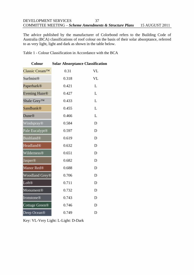
The advice published by the manufacturer of Colorbond refers to the Building Code of Australia (BCA) classifications of roof colour on the basis of their solar absorptance, referred to as very light, light and dark as shown in the table below. Table 1 - Colour Classification in Accordance with the BCA
Colour Solar Absorptance Classification
Classic Cream™ 0.31 VL
Surfmist® 0.318 VL
Paperbark® 0.421 L
Evening Haze® 0.427 L
Shale Grey™ 0.433 L
Sandbank® 0.455 L
Dune® 0.466 L
Windspray® 0.584 D
Pale Eucalypt® 0.597 D
Bushland® 0.619 D
Headland® 0.632 D
Wilderness® 0.651 D
Jasper® 0.682 D
Manor Red® 0.688 D
Woodland Grey® 0.706 D
Loft® 0.711 D
Monument® 0.732 D
Ironstone® 0.743 D
Cottage Green® 0.746 D
Deep Ocean® 0.749 D
Key: VL-Very Light: L-Light: D-Dark

DEVELOPMENT SERVICES COMMITTEE MEETING – Scheme Amendments & Structure Plans 15 AUGUST 2011
38
Accordingly Clause 5.9 of TPS No.4 was drafted to limit the use of zincalume, metallic or white coloured finish for external building materials on land east of the Albany and South West Highways as follows: 5.9 Use of reflective materials 5.9.1 No building structure, shall be constructed east of the Albany Highway from the City’s
northern boundary to its junction with the South Western Highway and thereafter east of the South Western Highway, with any external sheeted surface of zincalume, metallic or white coloured finish, without the City’s approval.
5.9.2 The City may approve the development of buildings or structures involving a roof or
walls with any external sheeted surface of zincalume, metallic or white coloured finish, with or without conditions, or may refuse to approve the application, having due regard to:
(a) the potential impact on the amenity of the locality; and (b) the objectives and relevant performance criteria in the Residential Design Codes. Policy PLN 2.2 – Use of Reflective Materials on Residences – was adopted in September 2005 to accompany the Scheme provisions (which require Council approval for the use of roof materials of zincalume, metallic or white coloured finish east of Albany/South West highway). The provisions provide Council with guidance in assessing an application proposing to use reflective material. The matters to be taken into account in making the discretionary decision range from distance to boundaries, roof pitch, views of the proposal from afar to the floor levels of the proposed building. The method of advertising a proposal and seeking alternative cladding is set out in the policy. (Refer to copy of Policy PLN 2.2 at Attachment “A1” of the Agenda, (refer Summary of Attachments - yellow page). Interpretation The Scheme provisions and associated policy (PLN 2.2) controlling the use of reflective building materials are unusual, possibly unique, in the metropolitan region. Whilst to date there have been no reviews presented to the State Administration Tribunal questioning the validity of the City’s controls on reflective materials, officers have found it difficult to administer the provisions for the following reasons: • Clause 5.9 makes reference to “white coloured finishes” which raises debate with
applicants over what colours constitute white. The colorbond colour “off white” for example has been considered by officers to constitute a white finish, however some applicants have argued “off white” to be more grey than white. This wording of the clause is ambiguous and open to misinterpretation.
• The manufacturers develop new colours and assign non colour descriptive names to them
which causes further confusion. For example, “off white” has since changed to “Surfmist”. Technically these colours would not be restricted as they are not specifically mentioned in Clause 5.9.

DEVELOPMENT SERVICES COMMITTEE MEETING – Scheme Amendments & Structure Plans 15 AUGUST 2011
39
• Single Houses in the Residential zone are not subject to Planning approval and
consequently there is greater potential for an unwary applicant or owner to erect a reflective roof by mistake. In the event a non-compliant roof was brought to the attention of the City, the roof would either be subject to retrospective approval or the City would need to instigate legal action to have the roof removed at considerable cost to the applicant and the City. The City has been involved in at least two recent cases in the last year which resulted in the granting of retrospective approval.
• The clause is discretionary and PLN 2.2 provides an avenue for applicants to seek
approval. PLN then places onus on officers to determine potential impacts of glare, which is considered to be highly subjective and impracticable to assess. Notwithstanding, officers are of the view that all roof colours reflect, including darker colours.
• The planning grounds to refuse an application on reflectivity are weak and unlikely to be
upheld by the State Administrative Tribunal. There are many examples of precedent throughout the City, which applicants often site as justification.
• Advertising of such proposals very rarely elicit objections which indicates the community
is either generally accepting or not really concerned about roof reflectivity. Reflectivity versus Visual Aesthetics It is important to note that the intent of Clause 5.9 and objectives of PLN2.2 is to preclude materials due to potential reflectivity or impacts of glare only. It does not extend to or preclude the use of such colours and materials on visual aesthetic grounds. Even though there are scientific methods to determine how reflective a material is, this information is not readily available and is primarily used to determine the thermal quality of material as opposed to the impact of glare. Notwithstanding this, there is no accurate or practical way of measuring the precise impacts of glare on third parties. Glare is an everyday occurrence, is changeable and unavoidable. Depending on individual circumstances, landowners affected by glare are best suited to mitigate such impacts through screening methods including, planting vegetation, shade structures, window tinting etc. The fundamental point to this debate is that all materials reflect to a degree (including windows, paved surfaces, swimming pools, solar panels etc) and therefore it is considered unreasonable and impractical to target specific lighter colours in the colorbond steel range. Whilst to date the focus has been on colorbond colours and absorptance values, it is important to note that other roofing materials such as concrete and glazed clay tiles also reflect and come in an array of colours and finishes. A scheme provision and policy based on precluding specific colours is fraught with administrative difficulties as it is not feasible to identify and prohibit every colour variance of all roofing products currently on the market, or in future for that matter.
DEVELOPMENT SERVICES COMMITTEE MEETING – Scheme Amendments & Structure Plans 15 AUGUST 2011
40
Other points of note include:
There is anecdotal evidence that highly reflective roofs can be found to occur with darker roofs and other roofing materials. (Bluescope Steel Corp indicate that most colours have a similar gloss level and would give similar mirrored reflection - so changing from lighter to darker colours may not considerably reduce the perceived glare as all materials are reflective to some extent – Technical Bulletin TB-28, Building materials, Thermal Efficiency and Reflectivity, Bluescope Steel 2010).
Manufacturers tend to coat materials with a gloss finish that results in the reflectivity of
all colours. From officer observations, the gloss appearance tends to fade overtime in any case.
Reflective roofs are increasingly being encouraged on environmental grounds to
facilitate cooler buildings. Light coloured roofs reduce the flow of heat from solar radiation better than dark coloured roofs, which require more insulation (at greater cost) to achieve the same absorptance values. Applicants are increasing using this as justification in support of lighter roof colours.
The colour "Classic Cream" (which has the lowest solar absorption classification) is
widely used and appears to be accepted in the community not having elicited any complaints whereas complaints have been forthcoming in respect of darker colours such as Manor Red.
New colours have been developed by manufacturers that are more reflective than those
mentioned under the TPS, yet technically these colours would not be restricted. Manufacturers are developing new colour and technologies constantly. For example, Bluescope Steel has recently developed a roofing product called “Thermatech” which reduces the heat absorptance of darker colours and reclassifies the absorptance values to light under the BCA Colour Classification. Such changes and advancements make it impracticable for the City to administer and control.
The Residential Design Codes (R Codes) do not specify acceptable building materials.
However, a 2008 amendment to the Codes provided that solar collectors were permitted by right (whereas previously they were required to be not visible from the primary street or to be visually obtrusive). This indicates a growing tendency for authorities to place sustainability measures over considerations of amenity.
There is no guarantee that restrictions on reflective roofs, even if effectively implemented, will result in a total lack of community complaints about some roofs. While such complaints have been relatively few since the provision was included in the Scheme, it is possible to receive complaints regarding roofs that have complied with the City’s controls. Certainly there are many complaints received by officers from applicants and the building industry who feel that the current constraint is onerous and inappropriate.

DEVELOPMENT SERVICES COMMITTEE MEETING – Scheme Amendments & Structure Plans 15 AUGUST 2011
41
Visual Aesthetics Council may consider it more appropriate to restrict certain colours or materials based on aesthetic grounds, however the same difficulties arise as discussed previously in isolating which colours may or may not be appropriate in a statutory sense. Whilst the colour issue is considered too difficult to administer, it is more feasible to prohibit specific roof materials such as zincalume. It could be argued that the unpainted zinc finish lacks aesthetic appeal. However, the difficulty with prohibiting zincalume across the board is that the material has been permitted and is utilised on structures throughout the City, with the exception of areas zoned Special Residential. The general issue of controlling such development where planning approval is not required would still remain. Special Residential Zone There is merit in precluding the use of zincalume on visual amenity grounds in the Special Residential zone. The implementation of private restrictive covenants in these areas has prohibited the use of zincalume to date. Whilst the City is not bound by such covenants, the City has strongly supported this stance over the years and has consistently not permitted the use of zincalume in these areas. Lighter colours however including off white have been permitted and exist within most estates. In this regard, it is considered feasible and reasonable to continue to prohibit the use of zincalume in the Special Residential zone. It is noted that planning approval is required for single houses in the Special Residential zone. General / Rural Living Zone Zincalume is quite common in Rural zoned areas and its appearance can be considered to be in keeping with rural amenity and character. The visual impact of zincalume and lighter colours is also mitigated to a large extent in rural areas by well treed and vegetated properties. Although it could be argued that lighter colours are less in keeping with the rural character and therefore there may be merit in precluding light colours, the same can be argued for some darker colours such as Ocean Blue, Manor Red and Grey, however such colours are widespread throughout the City. Whilst it is noted that planning approval is required for single houses in the Rural Living zone and the same restrictions as proposed for the Special Residential zone could be enforced, the visual impact of zincalume and lighter colours in rural areas is not considered significant enough to warrant control as previously discussed above. Notwithstanding, such materials and colours are widespread in rural areas and prohibiting their ongoing use would also prevent landowners from erecting minor extensions or additions to match existing residences/structures which already utilise such materials. In this regard, it is recommended that the use of zincalume and lighter colours in the General/Rural Living zones not be controlled or prohibited under TPS No.4

DEVELOPMENT SERVICES COMMITTEE MEETING – Scheme Amendments & Structure Plans 15 AUGUST 2011
42
Residential Zone The use of zincalume west of the highway is currently not prohibited under TPS No.4. Most new estates contain private covenants which prevent its application in any case. The use of zincalume is more prevalent in established areas, particularly on outbuildings but it is not a popular choice for roofing material. Light coloured roofs however are becoming increasingly popular. The use of reflective materials east of highway is currently prohibited by Clause 5.9 of TPS No.4. Historically, whilst zinc was prohibited without Council approval under TPS No.2, zincalume is relatively prevalent throughout the hills. Light coloured roofs are less prevalent, however, and are becoming increasingly popular which reflects the same trend in the residential areas to the west of the highway. As with rural areas, the visual impact of zincalume and lighter colours in the hills area is also considerably less where properties are well treed and vegetated. In this regard, it is recommended that the use of zincalume and lighter colours in the Residential zone east of the highway not be controlled or prohibited under TPS No.4. OPTIONS 1. Council could initiate the Scheme Amendment as proposed and revoke PLN 2.2 2. Council could decline to initiate the Scheme Amendment as proposed or modify the
provisions as appropriate. 3. Council could request the matter be held to be considered under the forthcoming review
of the scheme. CONCLUSION There are obvious practical difficulties with administering the current provisions that restrict the use of reflective roofs within the Hills areas of the City. The issue of reflectivity is considered to be too subjective and is undermined by the argument that all colours and material reflect to a similar degree. Prohibiting the use of certain lighter colours based on reflectivity is impractical and draconian. It is therefore recommended that the reflectivity provision (Clause 5.9) be deleted from TPS No.4. As such, PLN 2.2 becomes superfluous and should be revoked. There is merit however in prohibiting the use of zincalume on aesthetic grounds within the Special Residential zone. In this regard, it is recommended that a new clause be inserted to address this specifically. The proposed new provision would not be discretionary and therefore would not require a policy to support its interpretation.

DEVELOPMENT SERVICES COMMITTEE MEETING – Scheme Amendments & Structure Plans 15 AUGUST 2011
43
Following the closure of the advertising period, the proposed amendment and any submissions received during the advertising period will be forwarded to Council for its consideration for final adoption. Given the above, Option 1 is recommended.
RECOMMEND
That Council:
1. Pursuant to Part 5 of the Planning and Development Act 2005, initiate Amendment No.63 to Town Planning Scheme No.4 to amend the text by:
i) Deleting Clauses 5.9, 5.9.1 and 5.9.2 relating to the use of
Reflective Materials and renumber the remaining clauses in appropriate numerological order.
ii) Inserting a new Clause 5A.3 as follows:
5A.3 Prohibited Materials
5A3.1 In the Special Residential zone, no building or
structure shall use zincalume, galvanised or unpainted steel surfaces as an exterior finish.
2. Refers the above Amendment to Town Planning Scheme No.4 to the
Environmental Protection Authority (EPA) pursuant to section 81 of the Planning and Development Act 2005. Should the EPA advise that the amendment does not require assessment, advertise the amendment for a period of 42 days.
3. Authorise the Mayor and the Chief Executive Officer to execute the
Amendment documents. 4. Forward a copy of the amendment to the Western Australian
Planning Commission for information.
5. Revoke PLN 2.2- Use of Reflective Materials on Residences by publication of a notice of revocation once a week for two consecutive weeks in a local newspaper, in accordance with Clause 2.5(b) of Town Planning Scheme No.5.
Moved Cr _______________ Carried/Lost ( )

DEVELOPMENT SERVICES COMMITTEE MEETING – Miscellaneous 15 AUGUST 2011
44
RESIDENTIAL DESIGN CODES REVIEW WARD : ALL
DATE : 1 August 2011
REF : IM
RESPONSIBLE MANAGER
: EDDS
In Brief:-
A review of the Residential Design Codes has been undertaken and a revised draft with explanatory guidelines and a consultation paper have been released for a two month consultation period.
Recommend that Council note the report and make a submission and provide a copy to the Western Australian Local Government Association.
Tabled Items Nil. Officer Interest Declaration Nil. Strategic Implications 2.1 Long term planning and development that is guided by a balance between economic, social and environmental objectives. Legislation Implications Planning and Development Act 2005 SPP 3.1 Residential Design Codes Town Planning Scheme No.4 Council Policy / Local Law Implications PLN 3.1 Residential Density Development Budget / Financial Implications
• Nil Consultation
The Minister for Planning has released a revised draft of the Residential Design Codes for a two month public submission period.
Workshops have been held in regional locations to explain the proposed changes – EDDS attended the workshop in Rockingham.

DEVELOPMENT SERVICES COMMITTEE MEETING – Miscellaneous 15 AUGUST 2011
45
BACKGROUND A review of the Residential Design Codes has been undertaken and a two month public advertising period approved by the Minister for Planning. In announcing the review on 1st July 2011 the Minister invited all stakeholders involved in residential design and development in WA to provide feedback on the following issues:
changes to specific provisions, in particular those relating to overshadowing, privacy, ancillary accommodation and minimum parking requirements;
terminology changes and additional clarification of how to use the provisions;
new codes approval flowchart and processes;
renaming detailed area plans as area specific plans and inclusion of these into the codes
policy framework, to clarify the relationship of the codes to the subdivision process;
the use, format and accessibility of local planning policies;
proposed changes to the minimum site areas in R20 to R40 codings. In addition the Minister noted that the review suggested the removal of subdivision control from the R-Codes and instead include the controls in a separate WAPC policy. Comment on this specific proposal was sought, and it was advised that changes could be made at a later stage of the review if the idea was supported. To explain the Review the Department of Planning has released the following:
a Consultation Paper outlining the main proposed changes;
the Codes with proposed changes highlighted;
proposed revised Explanatory Guidelines (without changes highlighted);
proposed revised Explanatory Guidelines for previous Part 7 (now Part 6) relating to the design of higher density development (with changes highlighted).
This report is structured primarily to respond to the areas the Minister has sought comment, with additional comment provided where warranted. The suggested response is summarised in italics after each section.

DEVELOPMENT SERVICES COMMITTEE MEETING – Miscellaneous 15 AUGUST 2011
46
ANALYSIS OF PROPOSED CHANGES IDENTIFIED AS MOST SIGNIFICANT BY THE MINISTER Changes to specific provisions: Overshadowing The Codes have been expanded from the current provisions that restrict the extent to which buildings may overshadow adjacent properties (depending on the R Code density) to also require that a proposed building does not impact on existing outdoor living areas, major openings to habitable rooms, solar collectors and balconies or verandahs. There is no objection to this in principle. However, there is a subtle change proposed throughout the proposed Codes that seeks to ensure that applicants complying with the now described “deemed-to-comply” provisions do not need further assessment by a local government. The introduction of provisions that require a degree of interpretation is a recipe for dispute and uncertainty. The proposed provision requires the applicant to assess whether there is an “adverse impact” (which requires subjective judgement) on specific parts of an adjacent property (the applicant may not be privy to the details of the adjacent property and in any event this matter would be subject to technical interpretation). In conclusion, while the intent of proposed overshadowing provision is supported, it is impractical to apply as a Deemed-to-Comply Code provision. Privacy It is proposed to modify the privacy provisions to provide lesser setbacks for development in the higher density areas (R60 and above) but no change is proposed for R50 and below. An additional provision requires that screening be at least 75% obscure, permanently fixed and made of durable material. The above amendments to the privacy provisions are supported as being consistent with the strategy of the Codes to provide a sliding scale of provisions which aim to offer greater protection to lower than higher density coded areas. However, it is proposed to change the current requirement that the privacy requirements apply to development over 0.5m above natural ground level to development over 0.5m above “finished ground level”. There is no discussion as to whether filling to finished ground level would require planning approval or would be deemed-to-comply, or indeed what the level would be. This effectively would mean that a developer would be able to fill a property in such a way as to avoid meeting the privacy requirements – to the considerable detriment of adjacent owners. In addition, no interpretation has been provided for the concept of “finished ground level”.

DEVELOPMENT SERVICES COMMITTEE MEETING – Miscellaneous 15 AUGUST 2011
47
It should be acknowledged that all sites will not have a finished ground level that is the same from boundary to boundary to enable boundary fencing to provide adequate screening. If fill is greater than 500mm then the fill would need to be setback 1m from the boundary. This would create a raised platform of fill (finished ground level) that would have a house and outdoor living areas on top of it that would provide a clear view of neighbouring properties. Privacy screen requirements would not apply under the proposed change because the development would be built at finished ground level or only 100-200mm above finished ground level. The introduction of the concept of “finished ground level” would create confusion in the Codes as there would be implications to the provisions under 5.3 (Boundary set-back requirements), 5.6 (Site works requirements), and 5.7 (Building height requirements). While the proposed privacy setback modifications are supported, the proposed use of “finished ground level” as the basis on which the privacy requirement is measured is of serious concern as it completely defeats the purpose and public expectations of the privacy requirements. Ancillary accommodation The Code provisions which currently permit an additional 60m² dwelling associated with the main dwelling are proposed to be amended to permit a “supplementary dwelling” of up to 70m² floor area. It is argued that such an amendment could support affordable housing solutions and should not be necessarily related to the main dwelling either physically or by family relationship. It is agreed that the controls on ancillary accommodation have been too restrictive and that, provided siting controls were met, an additional unit could provide a useful response to the need to respond to a range of housing needs. It has in the past been difficult to prove that occupiers of the ancillary accommodation are related to occupants of the main dwelling. The other requirements relating to minimum lot size, open space and parking are retained. The proposed increase in floor area to 70m² results from a review of such accommodation throughout Australia and is supported. However, there is a need to define what is to be counted as “floor area.” The 2002 Codes set the requirements in terms of “plot ratio floor area” which was defined. The 2010 Codes reverted to “floor area” but failed to offer a definition. If the matter is not defined there will be dispute as to whether such areas as store rooms, lobbies, stairs and balconies are included. In conclusion, the changes to ancillary accommodation are supported subject to the need to define what is to be counted as “floor area”.
DEVELOPMENT SERVICES COMMITTEE MEETING – Miscellaneous 15 AUGUST 2011
48
Minimum parking requirements It is proposed to amend the parking provisions to reflect flexibility for on-site parking which relates to proximity to public transport, reciprocity, safety and convenience of design layout and access. Specifically 1 or 2 bedroom dwellings and all dwellings within 800m of a train station or 250m of a high frequency bus route would only need to provide one on-site parking bay. While there is logic in relating parking requirements to dwelling size and proximity to public transport it could result in planning problems in the future. It should be noted that the recent tendency to provide reduced road widths has resulted in less flexibility for off-site parking and while property owners may reduce their private car usage in certain situations, this may not translate into lower car ownership and a consequential lesser need to house vehicles. Notwithstanding the need to be cautious in reducing parking requirements, the proposed provisions are not objected to. Terminology changes and additional clarification of how to use the provisions Because of the reputed confusion in the terms used in the Codes it is proposed to substitute “Deemed-to-Comply” for “Acceptable Development” and “Design Solution” for “Performance Criteria”. The rationale for the change is that some local governments have adopted an approach that development which does not meet the “Acceptable Development” criteria is to be refused, notwithstanding that the proposal may be entirely appropriate for the site and the intended use. In addition, rather than refer to “Council” as the decision maker, it is proposed to use the term “Authority” which applies more broadly and could therefore include the WAPC. It is recognised that the Codes should encourage acceptable alternatives to the basic standard. However, it is inevitable that local governments will scrutinise applications not meeting the standard more carefully and possibly require consideration by Council rather than under delegated authority. This will continue to be the situation whatever the terminology. There is no objection to the proposed changed terminology.

DEVELOPMENT SERVICES COMMITTEE MEETING – Miscellaneous 15 AUGUST 2011
49
New codes approval flowchart and processes It is proposed to introduce a flowchart (copied below) to illustrate the decision making process. The rationale for the flowchart is to secure a more streamlined assessment process and discourage a planning assessment where not absolutely necessary. As in common with a number of the proposed changes to the Codes, they are a response to the development industry that has experienced difficulties in achieving approvals and thereby seek changes to the process to ensure that assessment and consultation is minimised. The flowchart illustrates the process as operated by the City of Armadale and there is therefore no objection. The flowchart fails to recognise that some local governments do legitimately require a planning application for a single dwelling on a lot greater than 350m².

DEVELOPMENT SERVICES COMMITTEE MEETING – Miscellaneous 15 AUGUST 2011
50
Renaming detailed area plans as area specific plans and inclusion of these into the codes policy framework, to clarify the relationship of the codes to the subdivision process Development Area Plans (DAPs) have been renamed Area Specific Plans (ASPs), to avoid confusion with the other recently adopted DAPs (Development Assessment Panels). Area Specific Plans are included in a new Part 7 of the Codes which also provides for local planning policies. Rather than ASPs being prepared under the scheme’s structure plan provisions it is now proposed that they be prepared in accordance with local planning policy processes. The City’s Scheme includes a specific provision (6A.5 Detailed Area Plans) which provides for a specific DAP preparation process and approval by the WAPC. No public comment is sought which is appropriate as the City uses DAPs in newly developing areas without established populations. The requirement to prepare such plans via a local planning policy process would be administratively cumbersome and unnecessarily complex and would therefore be of concern. As in past versions of the Codes the scope for varying the provisions by local planning policy is set out. It is now additionally proposed that where the WAPC’s approval is required to vary a provision it is it is now proposed that provisions be included to more precisely ensure that any such local planning policy (or ASP) is warranted, does not increase housing costs and can be audited. While the provisions are somewhat onerous, it is accepted that other than the listed areas where policies can legitimately amend the Codes, exceptions should only be in response to special circumstances. There is no objection to DAPs being named ASPs or the more regulated format to be applied to certain local planning policies, however the requirement to prepare ASPs via a local planning policy process would be administratively cumbersome and unnecessarily complex and would therefore be of concern in view of the current provisions of the City of Armadale TPS No.4. The use, format and accessibility of local planning policies To ensure that applicants have better access to local planning policies and ASPs it is proposed that they be included in the R Codes ring binder and be provided to the WAPC for inclusion on its website. An additional Appendix 5 provides the format for the setting out of local planning policies – the City already follows this format. While there is no objection in principle to including related policies and ASPs in the Codes ring binder, there may be practical difficulties and in any event applicants obtain hard copies of the Codes from the Department of Planning, not the individual local government and it could be onerous to the Department (or WAPC) to provide updated local government policies and ASPs. In any event, applicants may operate over a number of local government areas – all with different policies.

DEVELOPMENT SERVICES COMMITTEE MEETING – Miscellaneous 15 AUGUST 2011
51
The City of Armadale provides its local planning policies and DAPs on its website and these can be downloaded by applicants. DAPs normally relate to a specific area and accordingly they are downloaded via the City’s Intramaps On-line Mapping function which is available to the public. The prospect of relying on the WAPC website to secure accurate information pertaining to detailed local government and area specific policies is unlikely to be effective. Local government has a responsibility to ensure that information relating to properties is accurate and up-to-date and this should be sufficient without recourse to the WAPC website. The practical difficulties arising from the proposal to make all locally specific policies available via the WAPC should be reviewed. Proposed changes to the minimum site areas in R20 to R40 codings. It is proposed to amend Table 1 of the Codes to reduce the minimum lot size in the R20 – R40 codes. The minimum in R20 would be reduced from 440m² to 350m², in R25 from 320m² to 300m², R30 from 270m² to 260m², R35 from 235m² to 220m² and R40 from 200m² to 180m². The earlier Codes established a difference between the average and minimum acceptable lot size of around 10%. The rationale for this was that landowners and residents had the right to expect a particular density of development in their area as represented by the average (ie R20 = 20 dwellings per hectare = 500m² lots) and to vary this too much would undermine this. The rationale for the proposed widening of the gap between minimum and average is provided in the Consultation Paper as “to reflect the changing expectations of industry with regard to minimum lot areas”. It is further explained that “from the R20 density code through to the R40 density code, minimum site areas have been lowered to reflect the average site area of the next highest R-Code. This supports a minor change to the previous provisions to the extent that it supports lots sizes which are near to those allowed in the existing R-Code and may have similar development provisions.” While the proposal is described as a “minor” change, others may not see a reduction of lot size in R20 of 440m² to 350m² of being so inconsequential and to use as a rationale that it “reflects the changing expectations of industry” does not reflect any degree of balance in the review. Certainly it ignores the views of residents whose expectations are that there is certainty in how small lot sizes may fall to in their area. Notwithstanding the general concern regarding community expectations in specific coded areas, as long as the average lot size is retained, greater flexibility in the minimums in R20 to R40 codings probably offers a sensible response to the need to provide for a range in housing needs and accordingly the proposal could be supported.
DEVELOPMENT SERVICES COMMITTEE MEETING – Miscellaneous 15 AUGUST 2011
52
The removal of subdivision control from the R-Codes and instead include the controls in a separate WAPC policy. It is argued that the inclusion of lot size standards in the Codes confuses subdivision design with building design. It is stated that the removal of subdivision control will have no impact on the operation of the Codes as a basis for controlling development. While the revised draft code document has not progressed to the extent of giving effect to this proposal, it is raised as a matter upon which comment is sought. The specific R Coding of areas are a major feature of all Town Planning Schemes in Western Australia and presumably this would continue in the event of the specific provisions relating to lot size being generalised in the RD Codes themselves. The rationale for this proposed change is that:
Some Schemes have comprised R-Codes that do not match the characteristics of the local area with respect to existing lot sizes or shape. (This is no argument as if this is the case it is a consequence of the WAPC and the Minister having allowed it to happen during the Scheme review process).
In many cases the nominated R-Code is not well related to the subdivision so that a
proposal that might otherwise comply with the Scheme Map related Code does not in reality match the land area and/or geometry of the lot. (It is difficult to understand this logic. Since 2002 it has been clearly warned in the Codes that you cannot just assume that you can fit, say, 10 units on an R40 lot of 2200m² by dividing the average lot size of 220m² into 2200).
To respond to the need for redevelopment and planning new areas the Codes can be
more realistically administered if the development standards and site requirements match the size and geometry of the site as opposed to what the Scheme Map indicates. (Again this argument is rather obscure and is based entirely on what would be convenient for developers rather than the need to give consideration to the amenity of residents).
It is proposed that development should be based on the lot size rather than the R-Code.
(This indeed would be the consequence of the proposed change, however, what would be lost would be the simplicity associated with the application of similar development standards and expectations for all the houses in a specific area).
The proposal would provide greater variation in housing types in areas where lot sizes
are varied – larger lots would maintain larger areas of open space and in future these could allow for better subdivision. (This may be correct although it could result in an overbuilding of smaller sites).
DEVELOPMENT SERVICES COMMITTEE MEETING – Miscellaneous 15 AUGUST 2011
53
It is acknowledged that the Western Australian R Codes are different from those Codes operating in the Eastern States largely due to the link with subdivision and lot sizes. This has been considered by most to be a strength in that a range of amenity considerations can be matched to lot sizes so that the design standards are not just for, say, a single house but for a single house in a medium density zone. It has been considered in the past that landowners have expectations as to what low or medium density mean and this is enshrined in the R Codes. If the proposal is intent upon moving away from the relationship between density and amenity, it could be of concern. While the arguments and implications are rather unclear, if the changes purely provide greater focus on design considerations it would be supported. ANALYSIS OF OTHER PROPOSED CHANGES Objectives The General Objectives for the Codes and most of the specific objectives for each element have been revised. In each case the revision has resulted in a longer, more complex and less understandable objective. Possibly this is due to the desire to cover everything or possibly due to the well known consequence of drafting by committee. The Consultation Paper advises that as a result of detailed investigations with the broader stakeholder groups the General Objectives have been reduced in number. This is true, but each is longer and convoluted. It is preferable for objectives to contain a single concept – multiple concepts such as the proposed 1.3.1c, lack clarity and utility:
“Design which is sensitive to culture and respectful of heritage yet offers future residents the opportunities for better living choices and affordability in an intergenerational context.”
Similarly the proposed changes to the objectives for each element offer less clarity than the original, for example the objective for Building Height: Current objective – “To ensure that the height of buildings is consistent with the desired scale in a given locality”; is proposed to be changed to:
“To ensure that design provides an appropriate scale, in terms of the bulk and height, that suits the scale of the street and the surrounding buildings, or in precincts undergoing a transition, proposed bulk and height needs to achieve the scale identified for the desired future character of the area in local planning policies or area specific plans.”
It is suggested that the proposed objectives be reviewed in the interest of clarity and utility.

DEVELOPMENT SERVICES COMMITTEE MEETING – Miscellaneous 15 AUGUST 2011
54
Variation to the minimum and/or average site area Section 5.1.3 of the Codes guide the Commission and local government on the extent to which the lot sizes of the Codes may be varied. Criteria are set out which limit the extent of this discretion to vary which have previously stated that no variation should be more than 5% less than the lot size on Table 1 and meet one or other of listed criteria relating to heritage, environment or other desirable outcomes. It is proposed to amend the wording in such a way that it could be interpreted that the limit of the variation to 5% no longer applies. This may not be intended but it would probably be the consequence. It is suggested that instead of using the words “would meet one or more of the following criteria” that the phrase be deleted and be transferred to follow the first criteria, ie “be no more than five per cent less in area than that specified in Table 1 and would meet one or more of the following criteria:” Existing clause 6.1.3 A3iii has been deleted in the proposed Code without any acknowledgement or reasoning. Presumably this is a mistake as the clause, which allows for the development of an existing lot notwithstanding it being smaller than indicated on Table 1, has merit and would result in some owners of serviceable land in established areas being unable to develop their land. While there may not be objection in principle to the proposed amendment to the minimum and/or average site area provisions, review of the precise wording is required. Buildings on boundary It is proposed that there be greater permissibility to build on the boundary in the R20 and R25 codes. Walls are proposed to be increased from 3m to 3.5m with the average increased from 2.7m to 3m and wall length increased from 9m to 12m. These proposed provisions are effectively the same as for the R30 Code. The original philosophy behind allowing walls on the boundary by right in the lower codes was to permit the construction of garages. The Consultation Paper indicates that the proposals “reflect current building standards and expectations,” without any further justification. The changes probably respond to the preferences and expectations of the building industry, but are equally likely to be at odds with the desires of neighbours. As with nearly all the other proposed changes to the Codes, they reflect the aspirations of the development industry to loosen standards – standards are not proposed to be tightened to reflect the concerns of those being impacted upon by new development. The R Codes should provide a balance between the needs of development and those being impacted – this does not appear to be reflected in this review of the Codes.

DEVELOPMENT SERVICES COMMITTEE MEETING – Miscellaneous 15 AUGUST 2011
55
Notwithstanding the general concern regarding the lack of balance in the proposals, it is accepted that building a garage on the boundary is sensible in a broader range of codes and indeed the City permits such development by local planning policy in R17.5 Coded areas. An additional common request is to permit patios and carports up to 500mm of a boundary (rather than 1m) if constructed of non-combustible material. The proposal to provide the right to build 3.5m high, 12m long walls on the boundary by-right without consultation in R20 and R25 codes is of concern. However greater allowance to build less imposing structures on (garages) or closer (patios and carports) to the boundary in a wider range of codes would be supported. Landscaping Additional requirements are provided, notably the need for retention of trees of over 3m in communal open space. This is supported, and it is noted that the City’s local planning policy relating to residential density development was amended after considerable Council deliberation to provide for the preservation of mature trees, the provision of a community focus and the planting of individual mature trees. Outbuildings It is proposed that outbuildings be setback in accordance with the Building Code of Australia. The current RD Codes require outbuildings to setback from a common boundary in accordance with Table 2a – which for most outbuildings means a 1metre setback, or possibly 1.5m setback for longer outbuildings. This proposal is a significant change that will impact on residents. The proposal would reduce the setback to nil in most cases. It should be understood that the BCA does not address setbacks except in respect of fire risk. The proposal would reduce the setback for detached outbuildings to 900mm where proximate to a dwelling under section 3.7.1.4 of the Building Code, however, for most situations (ie where the outbuilding is more than 1.8m from a Class 1 building) there would be no setback requirement under the BCA. Council has considered proposals in the past where there has been a negative reaction from neighbours to the construction of outbuildings in the adjacent property notwithstanding that the RD Codes standards have been met. It can be anticipated that the proposed amendment would result in outbuildings being even less acceptable within the community. While there may be some merit in allowing small outbuildings (say 10m² in floor area) some dispensation, the proposal to substitute the Building Code for Table 1 for the determination of setbacks would permit outbuildings with areas of 60m² and a height of 4.2m to be built on the boundary by-right and would therefore be unacceptable.

DEVELOPMENT SERVICES COMMITTEE MEETING – Miscellaneous 15 AUGUST 2011
56
Aged or Dependent Persons Dwellings It is proposed to reduce the permitted floor area of aged persons dwellings from 100m² to 70m² (single and grouped) and from 80m² to 60m² (multiple dwellings). The argument is made in the Consultation Paper that achieving the open space standards while also reducing the lot area by one third has resulted in it being difficult to develop floor areas of 100m² in the medium density codes. The Codes provisions relating to Aged or Dependent Persons Dwellings have not provided a sufficient incentive to deliver this form of housing which is increasingly needed throughout the State. The opportunity should be taken in the Review to give greater encouragement to the construction of such accommodation. The reasoning concerning floor area changes for aged and dependent persons dwellings does not appear compelling as developers have not been prevented from developing smaller units if they so chose. It is suggested that either a sliding scale of aged and dependent persons dwellings be provided whereby the allowable size of such dwellings is proportional to the size of the land parcel or that specific sized aged persons dwellings be more generally permitted in a wider range of R Codes. Single Persons Dwellings The maximum floor area for Single Persons dwellings is proposed to be extended from 60m² to 70m². The proposal to increase single person dwelling floor area to 70m² is supported as 60m² has been demonstrated to be too limited to attract the development of this type of accommodation which would provide for a real need in the market to accommodate small household units. Neighbour Consultation Part 4 of the Codes has been rewritten in response to concerns that neighbours are offering objections to matters which are Deemed-to-Comply and this is resulting in delays in determining applications. The proposed wording is not substantially different from the current Codes except that the proposed wording emphasizes that consultation should only relate to areas of non-compliance and that the decision maker should only consider the public comment in the context of other information. The current Code provision allowing Councils to inform adjoining owners of a proposal has been deleted. The emphasis has changed in a number of subtle ways to minimise consultation and weigh against neighbour opposition. Notwithstanding this, it is recognised that the Codes have always stated that comment should not be sought on complying development and the City of Armadale follows the practice of only consulting where there is non-compliance and the specific areas of non-compliance are clearly pointed out during the process.
DEVELOPMENT SERVICES COMMITTEE MEETING – Miscellaneous 15 AUGUST 2011
57
It is possible that the additional wording is an over-reaction to practices of some local governments which should have been challenged by review to SAT rather than encumber the Codes with repetitive statements. While the changes to the Neighbour consultation section are not objected to, they clearly reflect the over-influence of development industry over local community input in this review of the Codes is of general concern. Explanatory Guidelines Changes have been made to the Explanatory Guidelines, however these have not been highlighted so they are difficult to discern. The Consultation Paper notes that the separation of the Explanatory Guidelines from the Codes in the 2008 amendment has made the use and interpretation of the Codes more difficult, resulting in a reluctance to consider flexible design responses. The 2008 separation of explanation from Codes is agreed by officers to have been a mistake. This has been compounded in the new draft by the tendency to include some explanatory wording in the Codes text which would be better left in the Explanatory Guidelines – this is probably a response to the knowledge that as few now read these Guidelines the text will not be observed. While it is a discipline to interleave guidelines with Codes text, the outcome is preferable as a query over text wording may be clarified by turning one rather than 50 pages. It is recognised that the original concept was to provide “explanatory text” which specifically aimed to clarify meanings of Code provisions. The more recent version of the Codes have introduced “Explanatory Guidelines” which provide considerable additional text and illustrations. While this may be helpful to some, it results in the Codes losing focus. It is agreed that the explanatory text be interleaved with Codes provisions and that development guidelines (where required) be in a separate document. OPTIONS Council could: 1. Make a submission on the review of the R Codes based on the above report. 2. Not make a submission on the review of the R Codes. 3. Make an alternative submission on the review of the R Codes.

DEVELOPMENT SERVICES COMMITTEE MEETING – Miscellaneous 15 AUGUST 2011
58
CONCLUSION The main areas identified by the Minister for comment are generally supported apart from:
The need to review the practical implementation of the proposed overshadowing deemed-to-comply provisions;
The unacceptability of the application of “finished ground level” rather than “natural ground level” for privacy assessment;
The need to establish a definition for “floor area” if “plot ratio floor area is to be dispensed with;
The increasing complexity associated with the proposed requirement that Area Specific Plans be subject to local planning policy processes;
The need to review the practicality of local variations being accurately sourced from the WAPC website.
Provided the sliding scale of amenity standards continued to relate to different R Codings (ie for building on boundaries, open space, setbacks and overshadowing), the proposal to remove subdivision control from the RD Codes could be supported.
Other comments should also be made, including:
The Objectives should be further reviewed in the interest of clarity and utility; The wording of proposed clause 5.1.3 to ensure that there is a limit to variations to the
minimum lot size be amended and the provision to enable existing small lots to be developable should be reintroduced;
The requirement that the setback of outbuildings should be in accordance with the Building Code would result in unacceptable impacts on neighbours without consultation;
There is insufficient rationale to revise the maximum floor area for aged persons dwellings;
Explanatory notes should be interleaved between the main sections of the Codes and separate Explanatory Guidelines be provided.
There is particular concern that in a number of ways the review appears to lack balance. It would appear that the proposed changes have been instigated by arguments presented by the building industry with the justification simply that proposals reflect building “expectations and standards”. The Codes should reflect a balance between the needs of development and the needs of those impacted by development. In particular the proposed changes relating to building on boundaries, nil outbuilding setbacks and reduced minimum lot sizes reflect this unbalanced approach. In addition the proposed greater scrutiny of policy variations, and the comments made in clause 2.1.2 (town planning scheme assessment processes), new provision 2.4 “judging merit of design solutions”, proposed 2.5.4 (approving deemed-to-comply applications) and Part 4 (neighbour consultation) all presuppose that local government needs greater supervision rather provisions seeking to secure a proper balance between the rights of those developing and those impacted upon by development.
DEVELOPMENT SERVICES COMMITTEE MEETING – Miscellaneous 15 AUGUST 2011
59
There is a need to provide a response to the excessive overbuilding of lots which is the source of many complaints but not addressed in this review of the Codes. There is little disincentive to build mansions with their associated large carbon footprint. It would be reasonable to provide greater incentive in the Codes to encourage builders to deliver smaller (say two-bedroomed) dwellings or to consider the merit of greater recourse to plot ratio controls. The multi-unit code sensibly pursued this approach for multiple dwellings, however its extension to other housing forms would be timely. RECOMMEND That Council: 1. Note the report on the review of the Residential Design Codes; 2. Agree that a submission to the Department of Planning be made in
accordance with the report and Attachment “A2” of the Agenda; and 3. Forward a copy of the submission to the Western Australian Local
Government Association. Moved Cr _______________ Carried/Lost ( )

DEVELOPMENT SERVICES COMMITTEE MEETING 15 AUGUST 2011
60
LATE ITEMS COUNCILLORS’ ITEMS EXECUTIVE DIRECTOR DEVELOPMENT SERVICES REPORTS In view of likely confidential aspects of this Report, public and staff in attendance, other than Chief Executive Officer and Executive Director Development Services, may be requested to retire from the meeting.
MEETING DECLARED CLOSED AT __________

DEVELOPMENT SERVICES COMMITTEE
SUMMARY OF “A” ATTACHMENTS 15 AUGUST 2011
ATTNO. SUBJECT PAGE
BUILDING
HEALTH
PLANNING
A1 COPY OF POLICY PLN 2.2 – REFLECTIVE MATERIAL ON RESIDENCES 62
A2 COPY OF PROPOSED SUBMISSION LETTER ON RESIDENTIAL DESIGN CODES REVIEW
64

DEVELOPMENT SERVICES ATTACHMENT “A1” COMMITTEE MEETING
62
PLN 2.2 USE OF REFLECTIVE MATERIALS ON RESIDENCES 1. INTRODUCTION Reflective materials may provide a disproportionate impact on the amenity of a locality and
should therefore be used with care, particularly in the more elevated and highly visible locations. This policy provides guidance in the exercise of Council’s discretion in approving the use of reflective materials for building.
This policy supersedes Policy T14/93 adopted by Council on 2 February 1993 which is
hereby revoked. 2. APPLICATION OF POLICY This policy will be applied where application is made under clause 5.9 of the Scheme which
establishes that no building/structure on land east of Albany Highway from the City’s northern boundary to its junction with the South Western Highway and thereafter east of the South Western Highway is to utilise material on a roof or walls with any external sheeted surface of Zincalume, metallic or white coloured finish, without Council approval.
3. POLICY OBJECTIVES
• to limit the glare arising from building materials; • to apply locational criteria to the siting of buildings with reflective roofing.
4. POLICY STATEMENT 4.1 Should an application be received showing that a residence is to be roofed using reflective
material, the application will be evaluated to determine if there is a possibility that the glare from this structure will have a substantial effect on any property within a close proximity or on rural amenity in the case of Rural zoned land.
4.2 The following factors may be taken into account in assessing the acceptability of the
reflective building material:
(a) Floor levels of the residence. (b) Floor levels of surrounding properties. (c) Distance from boundaries and other residences. (d) Degree of vegetation shielding the property. (e) Pitch of roof. (f) Design of the roof (direction of slopes). (g) Implications on nearby and more distant properties (across valleys). (h) Implications on rural amenity when viewed from public vantage points. (i) Implications on passing motorists. (j) The extent to which reflective building material would enhance energy efficiency
may be taken into account in assessing its acceptability.

DEVELOPMENT SERVICES ATTACHMENT “A1” COMMITTEE MEETING
63
4.3 Non-reflective type cladding material is encouraged on roofs in locations where the steepness of roof pitch may cause glare which could be injurious to adjacent neighbours, could impact on passing motorists or could be detrimental to the rural character of an area.
4.4 Should it be determined that glare may be a problem to one or more properties then those
property owners are to be contacted by The City so that they have the opportunity to view the proposal and make comments should they wish.
4.5 If any objections are raised or if the use of reflective material is considered to be
inappropriate, then the applicant is to be contacted and requested to change the roof material to colorbond or other suitable non-reflective material.
4.6 In cases where the applicant refuses to modify the material, the application may be
refused. NOTE: Typical absorption values are set out in the Australian Building Control Board’s RD2002-1 – Energy
Efficiency Measures – March 2002. D57/4/03 Development Services Committee 14 April 2003 - Adopted by Council 21 April 2003 D106/6/03 Development Services Committee 9 June 2003 - Adopted by Council 16 June 2003 D97/7/05 Development Services Committee 12 July 2005 - Adopted by Council 18 July 2005 D160/9/05 Development Services Committee 13 Sept 2005 - Adopted by Council 20 Sept 2005

DEVELOPMENT SERVICES ATTACHMENT “A2” COMMITTEE MEETING
64
PROPOSED SUBMISSION LETTER ON RESIDENTIAL DESIGN CODES REVIEW Director Policy Coordination and Development Department of Planning 140 William Street PERTH WA 6000 Dear Sir REVIEW OF STATE PLANNING POLICY 3.1 – RESIDENTIAL DESIGN CODES (R-CODES) At its meeting on 22nd August 2011 Council resolved to:
1. note the report on the review of the Residential Design Codes; 2. agree that a submission to the Department of Planning be made in accordance with the report;
and 3. forward a copy of the submission to the Western Australian Local Government Association.
A full copy of the report considered by Council is attached for your information and should be referred to for further explanation. The main areas identified by the Minister for comment are generally supported apart from those listed below. There is particular concern that in a number of ways the review appears to lack balance. The Codes should reflect a balance between the needs of development and the needs of those impacted by development. In particular the proposed changes relating to building on boundaries, nil outbuilding setbacks and reduced minimum lot sizes reflect this unbalanced approach. In addition the proposed greater scrutiny of policy variations, and the comments made in clause 2.1.2 (town planning scheme assessment processes), new provision 2.4 “judging merit of design solutions”, proposed 2.5.4 (approving deemed-to-comply applications) and Part 4 (neighbour consultation) all presuppose that local government needs greater supervision rather provisions seeking to secure a proper balance between the rights of those developing and those impacted upon by development. The response to the main matters identified by the Minister and other proposed changes is summarised below: PROPOSED CHANGES HIGHLIGHTED BY THE MINISTER: Overshadowing While the intent of proposed overshadowing provision is supported, it is impractical to apply as a Deemed-to-Comply Code provision. Privacy While the proposed privacy setback modifications are supported, the proposed use of “finished ground level” as the basis on which the privacy requirement is measured is of serious concern as it completely defeats the purpose and public expectations of the privacy requirements.

DEVELOPMENT SERVICES ATTACHMENT “A2” COMMITTEE MEETING
65
Ancillary accommodation The changes to ancillary accommodation are supported subject to the need to define what is to be counted as “floor area”. Minimum parking requirements Notwithstanding the need to be cautious in reducing parking requirements, the proposed provisions are not objected to. Terminology changes and additional clarification of how to use the provisions There is no objection to the proposed changed terminology. New codes approval flowchart and processes The flowchart illustrates the process as operated by the City of Armadale and there is therefore no objection. However, the flowchart fails to recognise that some local governments do legitimately require a planning application for a single dwelling on a lot greater than 350m². Renaming detailed area plans as area specific plans and inclusion of these into the codes policy framework, to clarify the relationship of the codes to the subdivision process There is no objection to DAPs being named ASPs or the more regulated format to be applied to certain local planning policies, however the requirement to prepare ASPs via a local planning policy process would be administratively cumbersome and unnecessarily complex and would therefore be of concern in view of the current provisions of the City of Armadale TPS No.4. The use, format and accessibility of local planning policies The practical difficulties arising from the proposal to make all locally specific policies available via the WAPC should be reviewed. Proposed changes to the minimum site areas in R20 to R40 codings. Notwithstanding the general concern regarding community expectations in specific coded areas, as long as the average lot size is retained, greater flexibility in the minimums in R20 to R40 codings probably offers a sensible response to the need to provide for a range in housing needs and accordingly the proposal could be supported. The removal of subdivision control from the R-Codes and instead include the controls in a separate WAPC policy. While the arguments and implications are rather unclear, if the changes purely provide greater focus on design considerations it would be supported.
DEVELOPMENT SERVICES ATTACHMENT “A2” COMMITTEE MEETING
66
OTHER PROPOSED CHANGES: Objectives It is suggested that the proposed objectives be reviewed in the interest of clarity and utility. Variation to the minimum and/or average site area While there may not be objection in principle to the proposed amendment to the minimum and/or average site area provisions, review of the precise wording is required. Buildings on boundary The proposal to provide the right to build 3.5m high, 12m long walls on the boundary by-right without consultation in R20 and R25 codes is of concern. However greater allowance to build less imposing structures on (garages) or closer (patios and carports) to the boundary in a wider range of codes would be supported. Outbuildings While there may be some merit in allowing small outbuildings (say 10m² in floor area) some dispensation, the proposal to substitute the Building Code for Table 1 for the determination of setbacks would permit outbuildings with areas of 60m² and a height of 4.2m to be built on the boundary by-right and would therefore be unacceptable. Aged or Dependent Persons Dwellings The reasoning concerning floor area changes for aged and dependent persons dwellings does not appear compelling as developers have not been prevented from developing smaller units if they so chose. It is suggested that the opportunity should be taken in the Review to give greater encouragement to the construction of such accommodation either by the introduction of a sliding scale of aged and dependent persons dwellings whereby the allowable size of such dwellings is proportional to the size of the land parcel or that specific sized aged and dependent persons dwellings be more generally permitted in a wider range of R Codes. Single Persons Dwellings The proposal to increase single person dwelling floor area to 70m² is supported as 60m² has been demonstrated to be too limited to attract the development of this type of accommodation which would provide for a real need in the market to accommodate small household units. Neighbour Consultation While the changes to the Neighbour consultation section are not objected to, they clearly reflect the over-influence of development industry over local community input in this review of the Codes is of general concern.

DEVELOPMENT SERVICES ATTACHMENT “A2” COMMITTEE MEETING
67
Explanatory Guidelines It is agreed that the explanatory text be interleaved with Codes provisions and that development guidelines (where required) be in a separate document. ADDITIONAL CONSIDERATIONS There is a need to provide a response to the excessive overbuilding of lots which is the source of many complaints but not addressed in this review of the Codes. There is little disincentive to build excessively large houses. It would be reasonable to provide greater incentive in the Codes to encourage builders to deliver smaller (say two-bedroomed) dwellings possibly by greater use of plot ratio controls. The multi-unit code sensibly pursued this approach for multiple dwellings, however its extension to other housing forms would be timely. Thank you for the opportunity to comment. Yours sincerely