Embed Size (px)
Citation preview

*
Building Setbacks
0 50 100 200 300 400m
1: 12,000@A3
Leppington Town Centre Masterplan
Client: Department of Planning
Jun 2012 10027-SK64
LEGEND
Site Boundary
Existing Creeks
Environmental Protection Overlay
Open Space + Drainage
Powerline Easement
Zero Setback
4m Setback
4.5m Setback
7m Setback
12m Setback
Significant Corners
Leppington Town Centre Masterplan | Final Report September 2012 | 34
5.3 Building AlignmentBuilding setbacks are used to define significant built form, natural corridors, or a change in streetscape character. They also provide a transition from one land use to another, reinforce important green links, or improve town centre pedestrian permeability.
Riparian, Flood & Biodiversity CorridorsEnvironmental and flood protection setbacks are provided along Kemps, Scalabrini and Bonds Creek corridors.
Commercial Core & Residential NeighbourhoodsThe town centre built form is defined by an inner commercial core generally built to development block frontages. Surrounding residential neighbourhoods incorporating setbacks for garden frontages and generous street tree planting.
Plazas, Sports Field & ParksBuilding frontages assist in defining town centre plazas, sports fields and district parks.
Heritage CurtilageA curtilage is provided around the Leppington Public School heritage buildings to ensure an appropriate setting. The Aquatic/Indoor Sports Centre is set back at the corner of Eastwood Road and Bringelly Road to provide a small square for the WV Scott Memorial.
InfrastructureBuildings are setback from electricity transmission corridors, from the SWRL corridor, and from the overbridge approach ramp embankments along Eastwood and Dickson Roads.
Landscape ZonesLandscape zones are proposed along major arterial roads to enhance the setting for business frontages and to screen buildings of industrial function. Landscaped setbacks are envisaged along the SWRL corridor, to link Leppington Station and the heart of the town centre to Bonds Creek.
Key Pedestrian LinkagesA network of town centre through-block pedestrian links will provide permeability, accessibility, interconnectivity and maximise walking catchment to public transport.
Significant CornersCorner buildings should provide suitable landmarks and social foci within the town centre. At visually prominent corners within the town centre, extra height will be considered to allow architectural corner features.
*
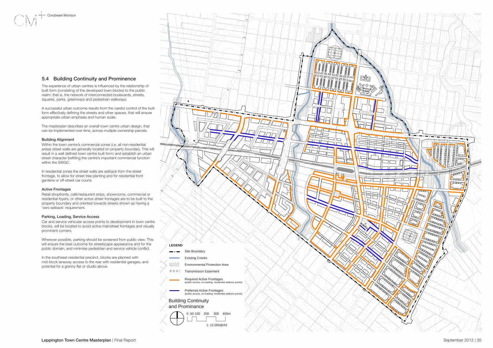
Building Continuity and Prominance
0 50 100 200 300 400m
1: 12,000@A3
Leppington Town Centre Masterplan
Client: Department of Planning
August 2011 10027-SK63
LEGEND
Site Boundary
Existing Creeks
Environmental Protection Area
Transmission Easement
Required Active Frontages(public access, no loading, residential address points)
Preferred Active Frontages(public access, no loading, residential address points)
Leppington Town Centre Masterplan | Final Report September 2012 | 35
5.4 Building Continuity and ProminenceThe experience of urban centres is influenced by the relationship of built form (consisting of the developed town blocks) to the public realm: that is, the network of interconnected boulevards, streets, squares, parks, greenways and pedestrian walkways.
A successful urban outcome results from the careful control of the built form effectively defining the streets and other spaces, that will ensure appropriate urban emphasis and human scale.
The masterplan describes an overall town centre urban design, that can be implemented over time, across multiple ownership parcels.
Building AlignmentWithin the town centre’s commercial zones (i.e. all non-residential areas) street walls are generally located on property boundary. This will result in a well defined town centre built form; and establish an urban street character befitting the centre’s important commercial function within the SWGC.
In residential zones the street walls are setback from the street frontage, to allow for street tree planting and for residential front gardens or off-street car courts.
Active FrontagesRetail shopfronts, café/restaurant strips, showrooms, commercial or residential foyers, or other active street frontages are to be built to the property boundary and oriented towards streets shown as having a ‘zero setback’ requirement.
Parking, Loading, Service AccessCar and service vehicular access points to development in town centre blocks, will be located to avoid active mainstreet frontages and visually prominent corners.
Wherever possible, parking should be screened from public view. This will ensure the best outcome for streetscape appearance and for the public domain, and minimise pedestrian and service vehicle conflict.
In the southeast residential precinct, blocks are planned with mid-block laneway access to the rear with residential garages, and potential for a granny flat or studio above.

Leppington Town Centre Masterplan | Final Report September 2012 | 36
6.0 Implementation
6.1 Planning FrameworkThe planning framework will comprise:
• A Precinct Plan under the Growth Centres SEPP which will include land zoning controls and development standards.
• A Development Control Plan containing urban design and built form controls.
In the longer term, the Precinct Plan and DCP will be incorporated into each of the Councils’ LEP and DCP. A key issue will be determining a structure that will allow documents to be easily integrated into the Councils’ planning frameworks.
Growth Centres SEPPControls for individual precincts are contained within appendices to the Growth Centres SEPP and are generally based on the Standard LEP template. Key provisions include (but are not limited to):
• Zoning objectives and land use tables• Minimum lot sizes• Residential densities• Height of buildings• FSR• Heritage • Restrictions on certain land uses eg. bulky goods in B7 zone• Acquisition of land• Development controls in environmental conservation zones
There are also a range of precinct specific controls, e.g. development controls for Special Areas such as Oran Park Town Centre.
Zoning OptionsThe following LEP land use zones are possible under the new DP&I template:
Land Use Suggested Zones Other Zones in Standard LEP
Residential R3 Medium Density Residential R1 General ResidentialR2 Low Density ResidentialR4 High Density ResidentialR5 Large Lot Residential
Business B3 Commercial CoreB4 Mixed UseB5 Business DevelopmentB7 Business Park
B1 Neighbourhood CentreB2 Local CentreB8 Metropolitan Centre
Industrial IN2 Light Industrial IN1 General IndustrialIN3 Heavy IndustrialIN4 Working Waterfront
Rural RU5 Rural Transition RU1 Primary ProductionRU2 Rural LandscapeRU3 ForestryRU4 Primary Production Small LotsRU5 Village
Special Purpose
SP2 InfrastructureAs per adjoining zones
SP1 Special ActivitiesSP3 Tourist
Recreation RE1 Public Recreation RE2 Private Recreation
Environment Protection
E2 Environmental Conservation E1 National Parks and E3 Environmental ManagementE4 Environmental Living
Waterways N/A N/A
The Precinct PlanThe Precinct Plan will define the land to which the planning controls apply, establish objectives for development of that land and specify permissible and prohibited uses (and exempt and complying development). The Precinct Plan will also establish new statutory development control provisions, such as maximum building heights, minimum subdivision lot sizes, residential densities and maximum floor space ratios for some land uses.

*
Staging
0 50 100 200 300 400m
1: 12,000@A3
Leppington Town Centre Masterplan
Client: Department of Planning
Jun 2012 10027-SK53
LEGEND
Site Boundary
Existing Creeks
Environmental Protection Area
Transmission Easement
Short Term
Medium Term
Long Term
Existing Use to be Retained
Leppington Town Centre Masterplan | Final Report September 2012 | 37
6.2 Staged ImplementationThe purpose of the Staging Plan is to highlight various opportunities in the development horizon of the town centre. The plan illustrates the most recent discussions with the DP&I on the availability of services to the various town centre precincts.
Whilst it does not reflect an ideal urban roll out, it is driven by provision of essential utility infrastructure, such as sewerage, water mains, etc.
The plan illustrated has not been based on any particular financial modelling. Stages are not fixed, and development sequence would likely be assessed against the likely future roll out of services infrastructure.
Stage 1 – Short Term (5-10yrs)The initial development phase will likely include the first stage of Leppington Shopping Centre, providing the initial employment in the centre, and establishing the retail and commercial core. This will evolve in subsequent stages, in response to the growing residential catchment.
Early completion is also anticipated for the southwest and southeast residential neighbourhoods and the northern residential neighbourhood to support SWRL patronage and the emerging retail land uses.
The first stages of bulky goods retail and of light industrial development (fronting Dickson Road) may also be completed during this phase.
Stage 2 – Medium Term (10-15yrs)This stage involves completion of the retail/commercial core, potentially including the mixed use precincts along Scalabrini Creek, the completion of the bulky goods retail precinct and the remaining residential neighbourhoods in the north and southeast - further boosting SWRL patronage, employment and supporting retail in the centre.
During this stage, the commuter car parks would be relocated to enable development adjacent to the station.
Light industrial uses would continue to grow and the first stages of the Community and Health facilities would also be established during this phase.
Stage 3 – Long Term (15-25yrs)The final stage will involve further expansion, with business/office park and light industrial infill, and delivery of significant government infrastructure in the Civic Precinct, the Aquatic & Indoor Sports Centre, and TAFE to serve the residential and worker population in the town centre.

Leppington Town Centre Masterplan | Final Report September 2012 | 38
6.3 Implementation StrategiesThe existing and potential future property ownership pattern has been an important consideration in the development of the urban design strategy for Leppington Town Centre.
The current configuration of the town centre site consists of largely unconsolidated privately owned lots. This presents masterplanning challenges, in terms of the timing of development, configuration of the town centre precincts and in provision of a sense of ‘completeness’ at each stage of development.
The handful of consolidated lots situated in the future retail precinct and the surplus parcels of land that will become available following the completion of the SWRL are seen as a key to unlocking of the potential of the town centre. The early development of these parcels would encourage and facilitate development by other property owners.
The State Government and the Councils (or developers on their behalf) will deliver some of the key new public streets to provide town centre access, construct drainage and stormwater infrastructure and establish community facilities, such as the Aquatic and Sports Centre and the community Sports Fields.
The urban design strategy establishes a town centre block and street structure that allows the progressive redevelopment of properties and the implementation of the town centre masterplan over time. Some parts of the masterplan will be developed in the short term, whilst others may take up to two decades or more to be finally realised.
Major public infrastructure projects will require the acquisition of private property for the construction of the SWRL, Leppington Station, commuter carpark, the town centre electricity substation, the upgrading of arterial and main roads and drainage infrastructure. Land will also be acquired to provide public open spaces for the growing numbers of town centre residents and workers.
The creation of the town centre public domain requires shared effort between private landowners/developers and government. Most landowners that wish to develop their properties will be required to construct and dedicate new town centre streets. Several opportunities have been identified where private development can contribute to the provision of parks and plazas for the benefit of the community.
It is anticipated that the masterplan would be progressively implemented. As each property is redeveloped, the legal property ownership would need to be reconfigured such that new public infrastructure for the streets, parks, drainage reserves and stormwater basins would be dedicated in perpetuity for public use to Liverpool or Camden Councils.
The land will ultimately be developed by the private sector in accordance with the new SEPP amendment and DCP controls. The masterplanning recommendations of this report will guide the formulation of the new development controls.
The key aspects of the implementation strategy include:• Utilising existing road corridor and road locations where
possible.• Locating new roads to be delivered by developers where
possible along existing property boundary lines.• Responding realistically to limits on S94 funding, particularly in
assigning public open space, riparian corridors and numbers of bridges required to cross creek floodplains.
• Looking for opportunities for the private ownership, development and ongoing maintenance of riparian corridors or flood prone open space, when development is located adjoining these areas.
• Plan for the staging of development to follow infrastructure delivery and supporting land uses.
• Coordinate the roll-out of development with the progressive RMS upgrade of new access road infrastructure.
• Encourage opportunities for private consolidation of lots in order to realise improved development outcomes.

Leppington Town Centre Masterplan | Final Report September 2012 | 39
7.0 Conclusion
The urban design strategy described in this masterplanning document and illustrated in the proposed Leppington Town Centre ILP, establishes a planning framework for the centre as it develops and grows over the next 25 years.
The proposed transit oriented masterplan establishes a sustainable town centre land use mix, circulation network, development parcels, and an appropriately scaled built form and public domain.
The town centre public domain, consisting of the new boulevards, streets, parks and plazas, will provide for a compact, walkable and legible town centre. This network of streets and spaces will offer the potential for an authentic urban life to develop which will provide the Leppington Town Centre with distinct identity as part of a metropolitan Sydney.