Embed Size (px)
Citation preview

1
2015 Island County Conservation Futures Fund
Dugualla Lake Conservation Easement Acquisition
Sponsor: Whidbey Camano Land Trust
Contact: Pat Powell
Address: 765 Wonn Rd C-201
Greenbank, WA 98253
Phone: 360-222-3310 Fax: 360-222-3510
E-mail: [email protected]
Parcel Numbers: R23307-101-3700 and R23307-101-3700
Landowner Names and Contact Information:
Joe Cerullo 4259 Cerullo Drive, Oak Harbor, WA 98277
Dave Burbank 726 NE Midway Blvd, Oak Harbor, WA 98277
Project Budget Summary: see budget sheet attached
Total expected Conservation Easement Value: $375,000
Total Direct Costs: $ 28,000
TOTAL Project Cost: $403,000
CFF Amount Requested: $ 30,000

2
Project Description: The proposal is to purchase conservation easements on two properties located on the north side of Dugualla Lake, located northeast of the City of Oak Harbor (please see map). If Conservation Futures Funds (CFF) is secured, it will provide the necessary match for the main funding source that is encroachment funds from the Navy. The purpose of the conservation easements is to remove development rights and to keep the properties open for agricultural and other open space pursuits. The total acreage is 56 acres— a 46-acre property and a 10-acre-property. There is one property located between the subject two properties that is not a part of this proposal; it is owned by Bonnie Newkirk. The project is a high conservation priority for the Whidbey Camano Land Trust. It is located within the Land Trust’s Dugualla Bay Protection Priority Area. This Priority Area runs from Skagit Bay on the east to the Naval Air Station Whidbey on the west. Much of the land in The Priority Area is diked farmland. The project meets many of the Land Trust’s target elements, including working farmland, freshwater lake and critical habitat. In addition, the project area is part of an important scenic view to travelers along State Highway 20, a designated state scenic byway, and for travelers on Frostad and Jones Roads. The project is a high protection priority for the U.S. Navy because it lies just east of a major runway at Ault Field on the main Naval Air Station base. The conservation objective of the Land Trust is to remove development rights and the Navy objective is also to remove development rights in high noise and safety zones.

3
*Line-item budget descriptions:
Conservation Easements: The Land Trust is requesting $30,000 from Conservation Futures in the 2015 cycle. The remaining funding, estimated at $xx of will be secured from the U.S. Navy. Other Acquisition Costs: Direct costs include Land Trust staff time, costs for legal agreements, appraisal, land survey, Environmental Assessments and closing costs. In the 2015 CFF cycle, the County limits reimbursable costs to 50% of the appraisal, survey, and title costs. However, it is proposed that the CFF funds will be used to purchase the conservation easements.
PROJECT NAME = Dugualla Lake Conservation Easement YEAR __2015__
Category CFF Other Funding Sources Total Funding
Planning
Salaries and Benefits -$ -$ -$
Consultants/Sub-Contracting -$ -$ -$
Goods and Services* -$ -$ -$
Travel & Per Diem -$ -$ -$
Other -$ -$ -$
Total Planning -$ -$ -$
Maintenance and Operations
Salaries and Benefits -$ -$ -$
Consultants/Sub-Contracting -$ -$ -$
Goods and Services* -$ -$ -$
Travel & Per Diem -$ -$ -$
Other -$ -$ -$
Total Maintenance / Operations -$ -$ -$
Management & Administration
Salaries and Benefits -$ -$ -$
Consultants/Sub-Contracting -$ -$ -$
Goods and Services* -$ -$ -$
Travel & Per Diem -$ -$ -$
Other -$ -$ -$
Total Management & Admin -$ -$ -$
Equipment
Technology Capital Items* -$ -$ -$
Technology Supplies* -$ -$ -$
Equipment* -$ -$ -$
Other -$ -$ -$
Total Equipment -$ -$ -$
Property Acquisition
Conservation Easements 30,000.00$ 345,000.00$ 375,000.00$
Other Acquisition Costs 28,000.00$ 28,000.00$
Total Acquisition Costs 30,000.00$ 373,000.00$ 403,000.00$
Total Budget 30,000.00$ 373,000.00$ 403,000.00$
* For all line items listed with "*", please provided an attached detailed list of items and costs
(does not include appraisal costs, survey, engineering or other technical services)
ATTACHMENT B
ESTIMATED PROJECT BUDGET
ISLAND COUNTY CONSERVATION FUTURES FUND
PROPOSED PROJECT APPLICATION

4
Project Narrative: A. Conservation Values & Resources: Value on fringes: leave buffer of alders/blackberry/pond edge/cattails
1. Habitat:
Biological function and environmental benefits: Upland vegetation along the north includes a fringe of conifer trees. Moving south are large areas of grassy fields until you get to the lakeshore. Vegetation between the fields and lake includes native Sitka spruce, western red cedar, red alder, Douglas fir, Indian plum, salmonberry, cattails, and Nootka rose. The properties include over 2,400 feet of undeveloped lakeshore, which is a very unusual feature in Island County.
Thousands and thousands western toads emerge on the properties from Dugualla Lake and migrate across the subject properties’ farm fields in mid-summer as they travel to upland forests off of Frostad Road. The western toad is federally listed as "near threatened", and is a species of concern in Washington State. The WA Department of Wildlife has only two other locations on Whidbey Island where the western toad occurs and it is likely that this property is vastly superior.
The Dugualla Lake properties are part of an important wildlife corridor piece that is identified as such in Element 7 of the Comprehensive Plan (Exhibit A) which connects Dugualla Bay to the Strait of Juan de Fuca. The fields and wetland edge along the Dugualla Lake properties supports migrating waterfowl such as Trumpeter Swans and Canada Geese. The hay fields provide hunting areas for raptors such as Bald Eagles, Northern Harriers, Red Tail Hawks and Kestrels along with a variety of owls. The lake edge and ditches, as well as wet areas of the field, provide additional habitat, especially critical for herpes and reptiles. provide
wetland habitat. Other species seen on the property include Bald Eagle, Trumpeter Swan, Kestrel, Canada Goose, Turkey Vulture, Egret, Great Blue Heron, Marsh Wren, and tree frogs. A variety of ground-nesting birds use the properties including Savanah Sparrows and Song and White-Crowned Sparrows. Juncos and other songbirds find refuge and food in the shrubby areas along the water conveyances and lakeshore.
Connectivity and Enhancement: The property is near 154 acres of wetland, upland and forested property owned by the Whidbey Camano Land Trust (30 acres at Dugualla Heights is a conservation easement). Also to the south is Dugualla State Park. The properties are an important upland part of a wildlife corridor that goes from Dugualla Bay to Dugualla Lake and then across the Island to the Strait of Juan de Fuca. Habitat Significance: This project is of local, regional and state significance due to the concentration of waterfowl that use it and the significant population of the western toad, which is a species of concern and near threatened in its state and federal classification. It is

5
also of federal and international significance because of its importance as a stopover for migratory birds that fly to other nations.
2. Water Resources: Removing any further development on the two properties, other than the one existing home site, will help protect this important watershed area. The conditions of the conservation easements will significantly limit the development of impermeable surfaces on the properties. This will keep the land in open agricultural use, so that they will continue to slow runoff from developed areas and surrounding road surfaces, facilitate groundwater infiltration, and filter pollutants before they enter Dugualla Lake. County information indicates that the water level is very high, which makes it good for non-irrigated crops and that there is a low-risk for seawater intrusion. In addition, the County indicates that the property has a moderate risk for contamination. There is also a freshwater spring on the Burbank property.
3. Working Farm & Agriculture: The formation of Diking District 3 was approved by Island County over 100 years ago. Subsequently, a dike and road was built (Dike Road) which created the large areas of existing diked farmland on the east side of Dike Road and State Highway 20. Since that time, the subject properties have been actively farmed up to the current date.
The properties’ soil is drained Coupeville loam, 0-3% slope, which is classified by the USDA as “Prime Farmland”. Prime Farmland soils are of national importance for meeting the nation’s needs for food and fiber. This soil is one of the most productive agricultural soils in Island County and is comparable to many of the prime farmlands in Ebey’s Reserve that are so highly touted. The mild marine climate allows for a long growing season, often from March into November. The subject properties are also sub-irrigated which allows them to produce a wide variety of non-irrigated crops. In addition, the ground is easy to farm because there are no rocks, it is level ground and weeds are not an issue. Today, and in the more recent past, the properties are both used to grow grass hay which is of very high quality with extremely good levels of protein, which makes it highly sought by livestock owners on the Island (and elsewhere). The farmer reports that 4-6 crops per year are produced from the properties with very high yields. This makes the properties some of the best producing grass hay ground in the County. However, the productivity of the soil means that a wide variety of crops will grow well on the properties. The property in-between grows blueberries which is a valuable commodity crop. Due to the high productivity of the soil (Prime Farmland), the mild climate and sub-irrigation that eliminate the need for irrigation, the number and quality of crops that can be produced on the properties, and the level and essentially weed- and rock-free quality of the ground, the properties are of local, regional and statewide significance for agricultural production. For the same reasons, the properties are highly suitable for farming and will continue to provide good agricultural income to the owners.

6
4. Working Forest: Not applicable; no forest lands on the properties.
B. Appropriate Public Use and Enjoyment: The Dugualla Lake farmland is an essential
part of the scenic view as seen by travelers on State Highway 20, a state scenic byway, and Frostad and Jones Roads, the latter two being heavily used County arterial roadways. This Dugualla area is specifically called out as one of the 25 important view areas in the Whidbey Scenic Isle Corridor Management Plan (CMP) adopted by Island County and the WA Department of Transportation. The CMP says it has natural (wildlife habitat), scenic (pastoral farm fields and impressive views of Mt Baker) and historic qualities (the long farming history of the area), stating that, “It is in this area that a singular culture of managing resources for the use of wildlife and farmers occurs.” There are pull-offs for travelers who want to look at the views and watch wildlife that give excellent views of the subject properties, including a parking area off the highway and another off of Dike Road. In addition, viewing is available on the Land Trust’s properties located on both sides of Dike Road. The historic values is, as mentioned in the CMP, the long history of farming of this area and the importance of this farming history to Whidbey Island. Given the physical characteristics of the property, It is not appropriate to have a public trail on the properties because the trails would not lead anywhere, i.e., no connections to other trails, and a public trail would disrupt the existing wildlife use of the properties and, necessarily because of how the farm fields lay, the agricultural operations. In addition, the wildlife congregating in the farm fields and along and in the Lake would be disturbed by close human presence which would cause flushing and use of calories. This is an important stop on the spring and fall migrations for birds to fuel up before continuing the long flights north and south. As mentioned above, there are many pull-offs in the vicinity where people can take photos and watch wildlife on the properties which negates the need for additional public access points on the properties.
C. Plan Consistency and Partnerships:
Plan Consistency: Protecting the properties will help accomplish many goals in Island County’s
Comprehensive Plan.
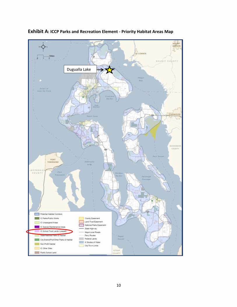
1. The Dugualla Lake properties are listed in the 2011 Parks and Recreation (and Habitat) Element of the Comp Plan as a high priority for habitat protection, including an important wildlife corridor between Dugualla Bay/Skagit Bay and the Strait of Juan de Fuca (Exhibit A).
2. The Natural Resources Element of the Comp Plan calls for the protection of agricultural
lands of significance, and important habitats including forests and wetlands. In a public

7
survey that was conducted for the Plan, many respondents identified agricultural
properties as important candidate sites for protection. Protection of this parcel will further
the following goals from the Natural Resources Element:
Goal 2 – Rural Character: To retain the county’s rural quality and character.
Goal 5 – Agricultural Protection: To conserve agricultural lands for the continued
profitable production of crops, timber and livestock.
Goal 7 – Protection of Community Assets: To protect natural scenic, cultural and
historic resources as community assets.
3. The Department of Fish and Wildlife identifies the project area as being important for the
concentration of waterfowl. The County’s recent Fish and Wildlife ordinance also recognized the waterfowl habitat importance of the subject properties. The properties are also seeing an increase in Snow Geese and Trumpeter Swans, in addition to many varieties of ducks that is becoming more of a draw for wildlife watchers, which includes a significant and growing segment of the population.
4. The Whidbey Scenic Isle CMP includes the subject properties as very important intrinsic values for the scenic corridor.
Support: Public support is signified in the public response to various surveys that have been taken in developing the different elements of the County’s Comprehensive Plan, most all of which stress the importance of maintaining working farmland and the scenic views that are valued by both tourists and residents, all of which contributes to the local economy. A 2014 report by the Island County Economic Development Council indicates that tourism brought in $174 million annually to Whidbey and Camano Islands. It is critical for Island County to maintain key scenic open spaces, like Dugualla Lake, that are critical to continuing to attract visitors, residents and businesses alike. In addition, the project is supported by Whidbey Island Audubon who leads many field trips to this area because of the variety and concentration of bird species.
D. Land Capacity Impact: Pre-Scored
E. Potential for Loss: There are Navy funds available which require this match and these
funds may run out if match for the project is not secured. The CFF request is the only matching funds possibly available. Without a conservation easement on the property, the scenic views could be compromised by structures (such as greenhouses, outbuildings, solar panels, wind mills, etc) put in the open space. Additional homes could also be built. The loss would be of prime farmland for local food production as well as scenic vistas that are important for tourism.

8
F. Assessment of Stewardship Viability: The property will continue to be privately
owned and managed, according to the terms of the conservation easement. According to Land Trust stewardship staff, monitoring these easements will be fairly easy given their proximity to county roads and easy viewing of them. The Land Trust pays for legal defense insurance on all properties and easements that it owns and has established a Stewardship Reserve Fund and Legal Defense Fund to permanently ensure it has the financial ability to monitor, manage and defend all of the lands it protects.
G. Financial Strategies: The vast majority of the funding will come from Navy funds. This
funding is available now but may not be in the future. The Navy funds require matching funds which include the requested CFF funds and donation of Land Trust staff time.

9
ANNUAL COMMISSIONERS’ BONUS POINTS:
H. Annual Commissioners Goals for Current Cycle: This proposed conservation easement project satisfies all four of the County Commissioners’ 2015 goals for the Conservation Futures program.
1. Jointly protects economic and conservation resources: The project jointly protects the economic and conservation resources of the property by protecting property that has prime farmland soils, is working farmland, has significance for a wide variety of wildlife species, including the near threatened western toad, and is highly important as part of the Whidbey Scenic Isle byway. In addition, reducing the development potential of the properties is economically important for the continuation of the Navy’s use of Ault Field.
2. Protects areas in or adjacent to Urban Growth and Joint Planning Areas: n/a regarding Urban Growth and unknown on Joint Planning Areas as could not find an adopted document on the website – only the Langley document was available.
3. Enhances public access to existing protected areas: The project will protect a part of an important wildlife corridor where there are ample pull-offs where the public enjoys watching the wildlife. If these properties were developed, an important wildlife watching area would be eliminated. A public trail, because of the special characteristics of the property, is not appropriate in order to protect farmland operations and wildlife habitat values.
4. Provides access to the shoreline for public use: No shoreline access available due to physical wetland constraints.
10
Exhibit A: ICCP Parks and Recreation Element - Priority Habitat Areas Map
Dugualla Lake

11
Exhibit B: Project Maps

12