Embed Size (px)
Citation preview
African Journal of Agricultural Research Vol. 7(7), pp. 1054-1067, 19 February, 2012 Available online at http://www.academicjournals.org/AJAR DOI: 10.5897/AJARX11.036 ISSN 1991-637X ©2012 Academic Journals
Review
A critical analysis of 2010 floods in Pakistan
Hashim Nisar Hashmi1, Qazi Tallat Mahmood Siddiqui1*, Abdul Razzaq Ghumman1, Mumtaz Ahmed Kamal1 and Habib ur Rehman Mughal2
1Department of Civil Engineering, University of Engineering and Technology, Taxila, Pakistan.
2Department of Civil Engineering, University of Engineering and Technology, Lahore, Pakistan.
Accepted 16 December, 2011
Pakistan has diverse geography with Northern alpines covered with glaciers and Southern Plains bordering the Arabian Sea. There are five big rivers flowing through the country from north to south namely the mighty Indus and its tributaries, that is, Jhelum, Chenab, Ravi and Sutlej. There is a well marked monsoon season from July to mid September in which most of the country receives rainfall. Riverine flooding is common in the low lying areas along the rivers during monsoon season while flash flooding is also experienced in hilly and semi hilly areas. Since its creation, Pakistan has faced severe floods in 1950, 1956, 1957, 1973, 1976, 1978, 1988, 1992 and now in 2010. These floods affected the basins of the rivers in Punjab and Sindh. In Khyber Pakhtunkhwa (KPK), Balochistan, Federally Administrated Tribal Areas (FATA), Gilgit Baltistan(G-B), Azad Jammu and Kashmir(AJK) and in some areas of Punjab, damages are caused mainly due to flash floods in secondary and tertiary rivers including hill torrents. Pakistan has suffered from the worst flood of its history in monsoon season of 2010. As per Damage Need Assessment (DNA) report of ADB /World Bank, the floods affected an area of about 160,000 km
2 (one fifth of the country), claiming about 1,985 lives, damaging around 1.5 million
houses, wiping out cropped area of more than 17 million acres, displacing a population of about 20 million and resulting in economic loss of PKR 10 Billion. Pakistan needs to do all it can to stop weather disasters becoming catastrophes and to protect people from future catastrophic flood disasters and increase the resilience of infrastructure, economies and communities including better emergency warning and evacuation systems, better flood protection for key infrastructure and plans to help communities recover once the waters recede. There is immense need for effective technical planning for flood damage mitigation in the country. This paper critically discusses in detail the causes and mechanism of 2010 flood on country wide basis. To prevent future catastrophic flood disasters, the priority improvements have been identified and recommendations have been made for effective flood risk management in the country. Key words: Flood management, flood damage mitigation, 2010 Pakistan flood.
INTRODUCTION Inundations due to floods have the potential to cause fatalities, displacement of people, and damage to the environment and thus severely compromise economic development. Flooding accounts for 40% of all the natural hazards worldwide and half of all the deaths caused by natural disasters (Ohl and Tapsell, 2000; Jonkman and *Corresponding author. E-mail: [email protected]. Tel: 00 92 51 9047 636. Fax: 00 92 51 9047 650.
Vrijling, 2008). Floods are natural phenomena which
cannot be prevented; nevertheless, some human activities contribute to an increase in the likelihood and adverse impacts of flood events ( European Parliament Council, 2007). First, the reduction of the natural water retention by inappropriate land use and river management (e.g. continuous embankments) increases the scale and the frequency of floods. Recent analyses
investigated such effects on flood hazard (Wooldridge et al., 2001; Camorani et al., 2006).
Second, there has been an increasing vulnerability of
flood-prone areas because of the growing number of people and economic assets located in flood risk zones (flood-prone areas are traditionally zones of special importance as they offer favourable conditions for human settlements and economic development). Finally, flood risk, that may be defined as the product of probability of flood and associated damage that is the damage expectation (Merz et al., 2007), increases with economic development given that potential damage increases. Resistance strategies of flood risk management are based on the construction of levees (Vis et al., 2003). The design of levees and other water-retaining structures is usually based on an acceptable probability of overtopping and the portion of risk that remains is called residual risk (van Manen and Brinkhuis, 2005). Residual flood risk behind levees is largely unaccounted. Levees are usually characterised by a uniform safety level (e.g. return period equal to 200 years). It implies that streamflows above the design discharge which may cause flooding anywhere and even at several locations at the same time, and therefore the evolution of the flood event is unpredictable. It is obvious that this condition is undesirable (e.g., in case of exceptional events a large area must be evacuated as all areas adjacent to the river theoretically have the same probability of flooding).
The so-called resilience strategy is a different approach to flood risk management. The concept of resilience originates from ecology (Holling, 1973) and was later on introduced, in the context of flood risk management (De Bruijn and Klijn, 2001). The idea behind the resilience approach is living with floods instead of fighting floods. In this approach, flooding is allowed in certain areas, whereas the impact of flooding is minimised through policies of land-use planning and management (Vis et al., 2003). There is need for integrated flood risk management in Pakistan.
This investigation was taken up to identify various weaknesses, gaps and flaws in the existing flood control
machinery in the country that experienced the worst ever floods of its history. The study was based on the survey of available records with the concerned organizations as well interview with the seasoned flood professionals with special focus on 2010 floods. The major aim of the study was to prevent future flood disasters through identification of the priority improvements and making technical recommendations for effective flood risk management in the country.
Causes of floods in Pakistan
The major cause of floods in Pakistan is heavy concentrated rainfall in the river catchments, which sometimes augmented by snowmelt flows, generally result into floods in rivers during the monsoon season. Occasionally, Monsoon currents originating in the Bay of Bengal and resultant depressions often result in heavy downpour in the Himalayan foothills additionally affected
Hashmi et al. 1055 by the weather systems from the Arabian Sea (Seasonal Low) and from the Mediterranean Sea (Westerly Wave) cause destructive floods in either or all of the main rivers of the Indus System. There are large seasonal variations in almost all the river discharges, which further aggravate the river course and morphology. There are five big rivers flowing through the country from north to south namely the mighty Indus and its tributaries that is Jhelum, Chenab, Ravi and Sutlej. The major storage reservoirs include Tarbela (existing Live Storage Capacity = 6.625 MAF against original 9.70 MAF), Chashma (existing Live Storage Capacity = 0.263 MAF against original 0.70 MAF) on River Indus and Mangla (existing Live Storage Capacity = 4.542 MAF against original 5.30 MAF) on River Jhelum. The Schematic details of Indus Basin river network are shown in Figure 1.
The major rivers cause flood losses by inundation of areas along their banks, by damaging irrigation and communication facilities across or adjacent to the rivers, and by erosion of land along the riverbanks. In the upper part of the Indus Basin System, floodwater spilling over the riverbanks generally returns to the river. However, in the lower part of Indus River (Sindh Province), which is primarily flowing at a higher elevation than adjoining lands, the spill flows do not return to the river. This phenomenon largely extends the period of inundation resulting in even greater damages. Although flood protection by embankments have been provided along almost the entire length in the Sindh Province and at many locations in the upper areas, the bund breaches can still occur. Such breaches often cause greater damage than would have occurred without the bunds because of their unexpected nature and intensification of land use following the provision of flood protection. The inadequate existing discharge capacity of some of the important structures (Barrages and Rail or Road Bridges) on Rivers Indus, Chenab and Ravi are another major reason of flooding. The exceptionally high floods thus result in afflux on the upstream side, which sometimes results in breaches in the flood embankments.
Some times, the flood embankments have to be deliberately breached at pre-selected locations to save the main barrage structures and other vital settlements and installations in the vicinity. The encroachment of village abadies in riverine areas has also increased the quantum of flood damages and losses to humans and livestock. As there is no proper regulatory frame work in the country regarding the settlement in riverine areas, most of the poor people have constructed their shelters along the vulnerable river banks and become victims to devastating floods. Some people are making the most of these areas for business purpose through promoting agriculture and cattle Ghats/dairies. All such activities are extending beyond the safe limits of riverine areas to achieve more economic benefits but in fact these activities are posing a great threat to unprecedented and unruly flood; the losses due to which may be in hundred

1056 Afr. J. Agric. Res.
Figure 1. Schematic diagram of Indus basin network.
multiples of such small scale economic profit. The river catchments and flood plains are to be kept as prohibited area for the riverine community especially during the flood season.
In recent years, vulnerabilities of large cities to flooding have increased. Cities like Karachi, Lahore and Rawalpindi have experienced flooding due to improper storm water drainage system to cope with heavy rains.
Global warming impact
Global Warming is emerging as a major drive of
disasters, with frequent and intense floods and storms, increasing forced displacement as an extremely likely consequence. The world weather crisis that is causing floods in Pakistan, wildfires in Russia and landslides in China is evidence that global warming predictions are correct. According to climate change experts, all these disasters happened more or less simultaneously as the result of a global climate pattern, yet each was reported as a separate event and interpreted as though there was no connection. According to the experts from World Climate Research Programme and the World meteorological Organization (WMO), the climate change
Hashmi et al. 1057
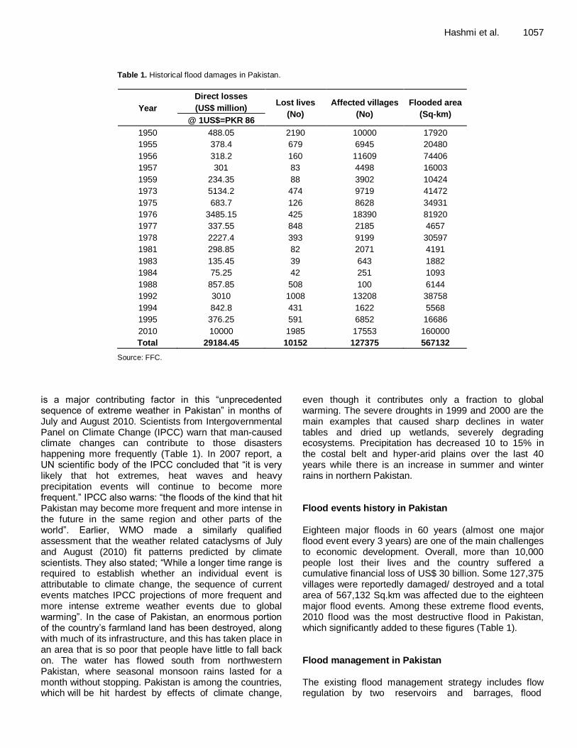
Table 1. Historical flood damages in Pakistan.
Year
Direct losses
(US$ million) Lost lives
(No)
Affected villages
(No)
Flooded area
(Sq-km) @ 1US$=PKR 86
1950 488.05 2190 10000 17920
1955 378.4 679 6945 20480
1956 318.2 160 11609 74406
1957 301 83 4498 16003
1959 234.35 88 3902 10424
1973 5134.2 474 9719 41472
1975 683.7 126 8628 34931
1976 3485.15 425 18390 81920
1977 337.55 848 2185 4657
1978 2227.4 393 9199 30597
1981 298.85 82 2071 4191
1983 135.45 39 643 1882
1984 75.25 42 251 1093
1988 857.85 508 100 6144
1992 3010 1008 13208 38758
1994 842.8 431 1622 5568
1995 376.25 591 6852 16686
2010 10000 1985 17553 160000
Total 29184.45 10152 127375 567132
Source: FFC.
is a major contributing factor in this “unprecedented sequence of extreme weather in Pakistan” in months of July and August 2010. Scientists from Intergovernmental Panel on Climate Change (IPCC) warn that man-caused climate changes can contribute to those disasters happening more frequently (Table 1). In 2007 report, a UN scientific body of the IPCC concluded that “it is very likely that hot extremes, heat waves and heavy precipitation events will continue to become more frequent.” IPCC also warns: “the floods of the kind that hit Pakistan may become more frequent and more intense in the future in the same region and other parts of the world”. Earlier, WMO made a similarly qualified assessment that the weather related cataclysms of July and August (2010) fit patterns predicted by climate scientists. They also stated; “While a longer time range is required to establish whether an individual event is attributable to climate change, the sequence of current events matches IPCC projections of more frequent and more intense extreme weather events due to global warming”. In the case of Pakistan, an enormous portion of the country’s farmland land has been destroyed, along with much of its infrastructure, and this has taken place in an area that is so poor that people have little to fall back on. The water has flowed south from northwestern Pakistan, where seasonal monsoon rains lasted for a month without stopping. Pakistan is among the countries, which will be hit hardest by effects of climate change,
even though it contributes only a fraction to global warming. The severe droughts in 1999 and 2000 are the main examples that caused sharp declines in water tables and dried up wetlands, severely degrading ecosystems. Precipitation has decreased 10 to 15% in the costal belt and hyper-arid plains over the last 40 years while there is an increase in summer and winter rains in northern Pakistan. Flood events history in Pakistan Eighteen major floods in 60 years (almost one major flood event every 3 years) are one of the main challenges to economic development. Overall, more than 10,000 people lost their lives and the country suffered a cumulative financial loss of US$ 30 billion. Some 127,375 villages were reportedly damaged/ destroyed and a total area of 567,132 Sq.km was affected due to the eighteen major flood events. Among these extreme flood events, 2010 flood was the most destructive flood in Pakistan, which significantly added to these figures (Table 1). Flood management in Pakistan The existing flood management strategy includes flow regulation by two reservoirs and barrages, flood
1058 Afr. J. Agric. Res.
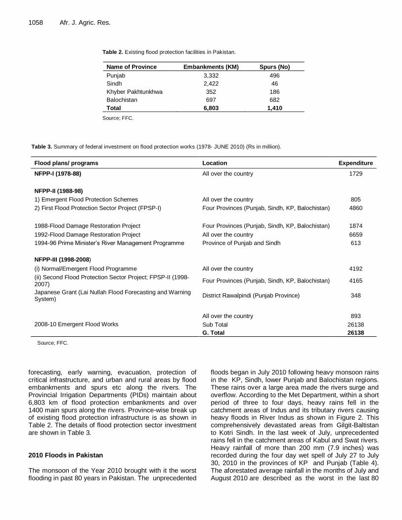
Table 2. Existing flood protection facilities in Pakistan.
Name of Province Embankments (KM) Spurs (No)
Punjab 3,332 496
Sindh 2,422 46
Khyber Pakhtunkhwa 352 186
Balochistan 697 682
Total 6,803 1,410
Source; FFC. Table 3. Summary of federal investment on flood protection works (1978- JUNE 2010) (Rs in million).
Flood plans/ programs Location Expenditure
NFPP-I (1978-88) All over the country 1729
NFPP-II (1988-98)
1) Emergent Flood Protection Schemes All over the country 805
2) First Flood Protection Sector Project (FPSP-I) Four Provinces (Punjab, Sindh, KP, Balochistan) 4860
1988-Flood Damage Restoration Project Four Provinces (Punjab, Sindh, KP, Balochistan) 1874
1992-Flood Damage Restoration Project All over the country 6659
1994-96 Prime Minister’s River Management Programme Province of Punjab and Sindh 613
NFPP-III (1998-2008)
(i) Normal/Emergent Flood Programme All over the country 4192
(ii) Second Flood Protection Sector Project; FPSP-II (1998-2007)
Four Provinces (Punjab, Sindh, KP, Balochistan) 4165
Japanese Grant (Lai Nullah Flood Forecasting and Warning System)
District Rawalpindi (Punjab Province) 348
2008-10 Emergent Flood Works
All over the country 893
Sub Total 26138
G. Total 26138
Source; FFC.
forecasting, early warning, evacuation, protection of critical infrastructure, and urban and rural areas by flood embankments and spurs etc along the rivers. The Provincial Irrigation Departments (PIDs) maintain about 6,803 km of flood protection embankments and over 1400 main spurs along the rivers. Province-wise break up of existing flood protection infrastructure is as shown in Table 2. The details of flood protection sector investment are shown in Table 3. 2010 Floods in Pakistan The monsoon of the Year 2010 brought with it the worst flooding in past 80 years in Pakistan. The unprecedented
floods began in July 2010 following heavy monsoon rains in the KP, Sindh, lower Punjab and Balochistan regions. These rains over a large area made the rivers surge and overflow. According to the Met Department, within a short period of three to four days, heavy rains fell in the catchment areas of Indus and its tributary rivers causing heavy floods in River Indus as shown in Figure 2. This comprehensively devastated areas from Gilgit-Baltistan to Kotri Sindh. In the last week of July, unprecedented rains fell in the catchment areas of Kabul and Swat rivers. Heavy rainfall of more than 200 mm (7.9 inches) was recorded during the four day wet spell of July 27 to July 30, 2010 in the provinces of KP and Punjab (Table 4). The aforestated average rainfall in the months of July and August 2010 are described as the worst in the last 80
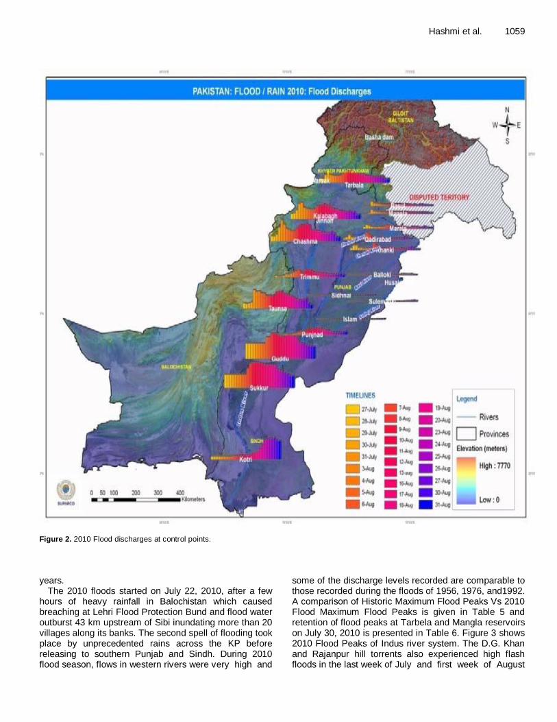
Hashmi et al. 1059
Figure 2. 2010 Flood discharges at control points.
years.
The 2010 floods started on July 22, 2010, after a few hours of heavy rainfall in Balochistan which caused breaching at Lehri Flood Protection Bund and flood water outburst 43 km upstream of Sibi inundating more than 20 villages along its banks. The second spell of flooding took place by unprecedented rains across the KP before releasing to southern Punjab and Sindh. During 2010 flood season, flows in western rivers were very high and
some of the discharge levels recorded are comparable to those recorded during the floods of 1956, 1976, and1992. A comparison of Historic Maximum Flood Peaks Vs 2010 Flood Maximum Flood Peaks is given in Table 5 and retention of flood peaks at Tarbela and Mangla reservoirs on July 30, 2010 is presented in Table 6. Figure 3 shows 2010 Flood Peaks of Indus river system. The D.G. Khan and Rajanpur hill torrents also experienced high flash floods in the last week of July and first week of August
1060 Afr. J. Agric. Res.
Table 4. Recorded rainfalls during the four day wet spell of July 27 to July 30, 2010.
City Rainfall (mm) Rainfall (inch) Province
Risalpur 468.0* 18.4 Khyber Pakhtunkhwa
Cherat 384.0* 15.1 Khyber Pakhtunkhwa
Saidu Sharif 338.0* 13.3 Khyber Pakhtunkhwa
Peshawar 226.1* 8.9 Khyber Pakhtunkhwa
Lower Dir 297.0 11.7 Khyber Pakhtunkhwa
Kohat 127.3 5.0 Khyber Pakhtunkhwa
Balakot 208.7 8.2 Khyber Pakhtunkhwa
Upper Dir 309.0 12.1 Khyber Pakhtunkhwa
Dera Ismail Khan 83.3 3.3 Khyber Pakhtunkhwa
Garhi Dopatta 346 13.6 Azad Kashmir
Rawalakot 297 11.7 Azad Kashmir
Muzaffarabad 292 11.5 Azad Kashmir
Pattan 242 9.5 Azad Kashmir
Islamabad 394 15.5 Capital Territory
Murree 373 14.6 Punjab
Kamra 308 12.1 Punjab
Lahore 288 11.3 Punjab
Mianwali *271 10.6 Punjab
Jhelum 269 10.6 Punjab
Sialkot 255 10.0 Punjab
Gujranwala 222 8.7 Punjab
Rawalpindi 219 8.6 Punjab
* Indicates new record
Source: PMD.
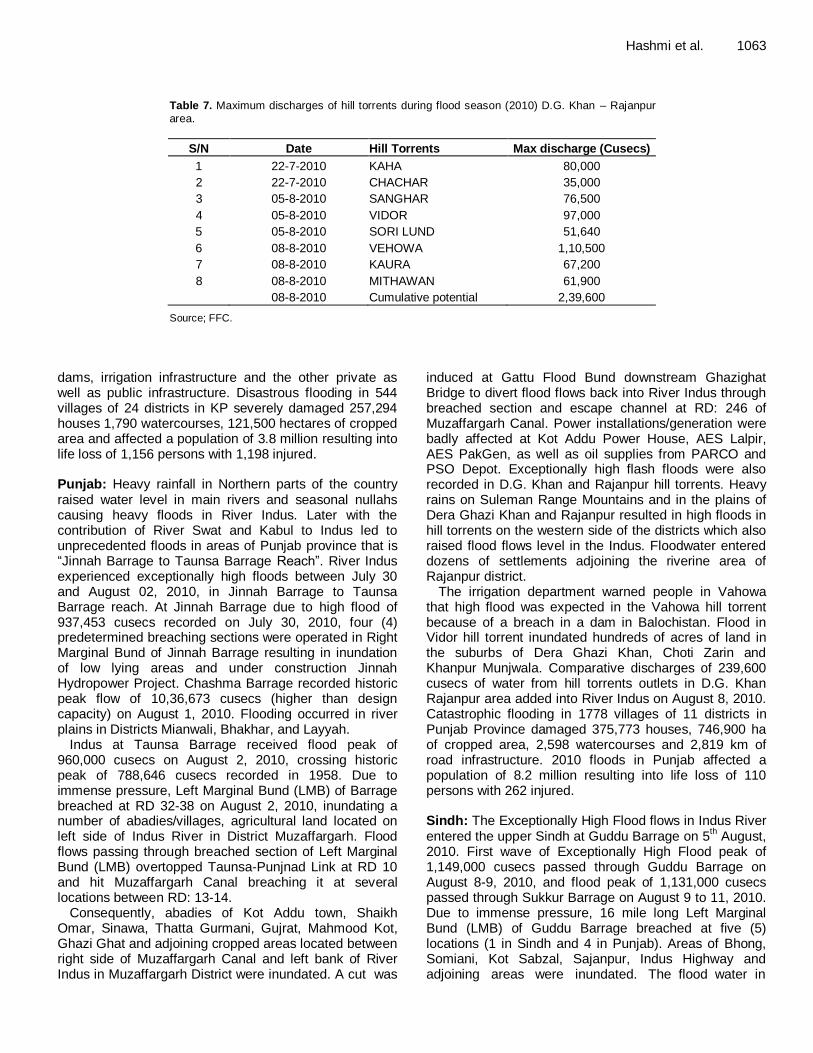
2010. Maximum discharges from hill torrents outlets in D.G. Khan and Rajanpur area are given in Table 7.
Official seasonal monsoon rainfall forecast
Pakistan Meteorological Department predicted Normal monsoon rains during the period from July to September 2010. On 21 June, the Pakistan Meteorological Department cautioned that urban and flash flooding could occur from July to September in the northern parts of the country. The official prediction of seasonal monsoon rainfall by Pakistan Meteorological Department, issued in this context, is reproduced hereunder (PMD, 2010):
“Meteorological data suggests that on all Pakistan basis the monsoon rains during July to September (2010) in most parts of the country are likely to be normal (+10%), which means that the over all availability of water in the country from monsoon rains would be sufficient. Due to high sea-land temperature contrast, the development of some mid-tropospheric circulations are likely in north Arabian Sea that may cause heavy rainfall events over southern areas of Pakistan (Sindh) during July to
September.
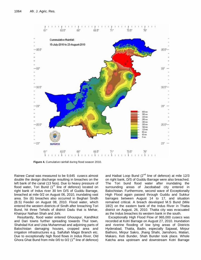
Due to the interactions of westerly-easterly waves, few very heavy rainfall events would also occur over north Pakistan that may cause urban/flash flooding during July to September. This is seasonal forecast with confidence level of 80% and meant for the planning purpose only. The normal area-weighted rainfall for July to September of Pakistan is 137.5 mm. The cumulative rainfall for 2010-flood season is shown in Figure 4.
Flooding pattern during flood season 2010
The 2010-floods were of unprecedented magnitude mainly triggered by the Indus and its tributaries having affected all the seven units of the country. These are discussed one by one:
Khyber Pakhtunkhwa: Khyber Pakhtunkhwa (KPK) was severely affected.
The unprecedented monsoon rains from July 27 to July 30, 2010, followed by historic floods caused major losses

Hashmi et al. 1061
Table 5. Historic maximum versus 2010 maximum peak discharges of major rivers of Pakistan.
River Barrages/Head-works/ Bridges
Designed Capacity
Historic maximum peak (cusecs) Maximum-2010 peak (cusecs)
Flood Date Flood Date
Indus
Tarbela 1,500,000 510,000 31-7-89 833,000 30-7-10
Kalabagh 950,000 950,000 14-7-42 937,453 30-7-10
Chashma 950,000 786,600 3-8-76 1,036,673 01-8-10
Taunsa 1,100,000 788,646 22-7-58 959,991 02-8-10
Guddu 1,200,000 1,199,672 15-8-76 1,148,738** 8 and 9-8-10
Sukkur 1,500,000* 1,166,574 15-8-76 1,131,000# 9 and 11-8-10
Kotri 875,000 981,000 14-8-56 964,900 27-8-10
Jhelum Mangla 1,060,000 933,000 10-9-92 344,400 30-7-10
Rasul 850,000 932,000 10-9-92 263,800 30-7-10
Kabul Warsak 540,000 150,680 8-7-78 152,710 30-7-10
Nowshehra - - - 249,100^ 10-8-10
Chenab
Marala 1,100,000 1,100,000 26-8-57 314,378 06-8-10
Qadirabad 807,000 948,530 11-9-92 329,483 07-8-10
Trimmu 645,000 943,225 8-7-59 328,926 11-8-10
Panjnad 700,000 802,516 17-8-73 310,000 13-8-10
Ravi Balloki 225,000 389,845 28-9-88 69,900 23-8-10
Sidhnai 150,000 330,210 2-10-88 27,600 28-7-10
Sutlej Sulemanki 325,000 597,000 8-10-55 58,300 03-9-10
Source; FFC. *Existing design capacity as reported by PID, Sindh is 900,000 cusecs; **Does not include flood flows passed through breach of LMB of Guddu Barrage; #Does not include flood flows passed through Tori Bund reach u/s Sukkur Barrage; ^The gauges were submerged at this discharge, it is estimated that a flood more than 450,000 cusecs passed through this point.
Table 6. Retention of flood peaks at reservoirs – July 30, 2010.
Reservoir Peak Inflow (cusecs) Peak Outflow (cusecs) Water Retained (cusecs)
Tarbela 833,000 604,000 229,000
Mangla 344,400 225,496 118,904
Total 347,904
Source; WAPDA
to life, crops, houses, infrastructure, that roads bridges,railway tracks, power installations, small dams, etc which were severely damaged due to flashy flood flow of secondary (Kabul,Swat and panjkora Panjkora) and tertiary rivers including local nullahs. More than 200 mm (7.88 inches) of rain fell within a period of 24-h over a number of places of KPK. A record-breaking 274 mm (10.7 inches) rain fell in Peshawar during 24 h surpassing the previous 187 mm (7.36 inches) of rain recorded in April 2009.
Rivers Swat and Kabul experienced record floods in excessive of 400,000 cusecs crossing previous historic
recorded flows of 1929 (250,000 cusecs) that caused inundation of Charsada, Nowshehra and adjoining areas. Exceptionally high floods were also recorded in Panjkora River, Budni/ other nullahs, as well as flash floods in D.I. Khan hill torrents. Areas badly affected include Districts Swat, Shangla, Upper and Lower Dir, Malakand, Mansehra, Charsadda, Mardan, Peshawar, Nowshera, Kohat, Karak, Bannu, Lakki Marwat, D.I. Khan and Tank.
Devastation was so massive that 278 bridges were damaged/ washed away, besides severe damages to 6,511 Kms of roads, Amandra, Munda and Kurram Garhi Headworks, 605 transformers and 5 Grid stations, small
1062 Afr. J. Agric. Res.
50.50 MAF below Kotri
April to September 30, 2010
3,44,400 – July 30, 2010
10,90,000 - 1992 Historic
10,60,000 Design Cap.
8,33,000 – July 30, 2010
5,10,000 - 1989 Historic
15,00,000 Design Cap.
9,37,453 – July 30, 2010
9,50,000 - 1942 Historic 9,50,000 Design Cap.
10,36,673 – Aug 1, 2010
7,86,600 - 1976 Historic 9,50,000 Design Cap.
9,59,991 – Aug 2, 2010
7,88,646 – 1958 Historic
11,00,000 Design Cap
11,48,738 Aug 8-9, 2010
11,99,672 -1976 Historic
12,00,000 Design Cap.
11,31,000 Aug 9-11, 2010
11,66,574 - 1986 Historic 15,00,000 Design Cap.
964,900 Aug 27, 2010
9,81,000 - 1956 Historic
8,75,000 Design Cap.
Figure 3. Historic versus 2010 flood peaks in Indus River network.
Hashmi et al. 1063
Table 7. Maximum discharges of hill torrents during flood season (2010) D.G. Khan – Rajanpur area.
S/N Date Hill Torrents Max discharge (Cusecs)
1 22-7-2010 KAHA 80,000
2 22-7-2010 CHACHAR 35,000
3 05-8-2010 SANGHAR 76,500
4 05-8-2010 VIDOR 97,000
5 05-8-2010 SORI LUND 51,640
6 08-8-2010 VEHOWA 1,10,500
7 08-8-2010 KAURA 67,200
8 08-8-2010 MITHAWAN 61,900
08-8-2010 Cumulative potential 2,39,600
Source; FFC.
dams, irrigation infrastructure and the other private as well as public infrastructure. Disastrous flooding in 544 villages of 24 districts in KP severely damaged 257,294 houses 1,790 watercourses, 121,500 hectares of cropped area and affected a population of 3.8 million resulting into life loss of 1,156 persons with 1,198 injured. Punjab: Heavy rainfall in Northern parts of the country raised water level in main rivers and seasonal nullahs causing heavy floods in River Indus. Later with the contribution of River Swat and Kabul to Indus led to unprecedented floods in areas of Punjab province that is “Jinnah Barrage to Taunsa Barrage Reach”. River Indus experienced exceptionally high floods between July 30 and August 02, 2010, in Jinnah Barrage to Taunsa Barrage reach. At Jinnah Barrage due to high flood of 937,453 cusecs recorded on July 30, 2010, four (4) predetermined breaching sections were operated in Right Marginal Bund of Jinnah Barrage resulting in inundation of low lying areas and under construction Jinnah Hydropower Project. Chashma Barrage recorded historic peak flow of 10,36,673 cusecs (higher than design capacity) on August 1, 2010. Flooding occurred in river plains in Districts Mianwali, Bhakhar, and Layyah.
Indus at Taunsa Barrage received flood peak of 960,000 cusecs on August 2, 2010, crossing historic peak of 788,646 cusecs recorded in 1958. Due to immense pressure, Left Marginal Bund (LMB) of Barrage breached at RD 32-38 on August 2, 2010, inundating a number of abadies/villages, agricultural land located on left side of Indus River in District Muzaffargarh. Flood flows passing through breached section of Left Marginal Bund (LMB) overtopped Taunsa-Punjnad Link at RD 10 and hit Muzaffargarh Canal breaching it at several locations between RD: 13-14.
Consequently, abadies of Kot Addu town, Shaikh Omar, Sinawa, Thatta Gurmani, Gujrat, Mahmood Kot, Ghazi Ghat and adjoining cropped areas located between right side of Muzaffargarh Canal and left bank of River Indus in Muzaffargarh District were inundated. A cut was
induced at Gattu Flood Bund downstream Ghazighat Bridge to divert flood flows back into River Indus through breached section and escape channel at RD: 246 of Muzaffargarh Canal. Power installations/generation were badly affected at Kot Addu Power House, AES Lalpir, AES PakGen, as well as oil supplies from PARCO and PSO Depot. Exceptionally high flash floods were also recorded in D.G. Khan and Rajanpur hill torrents. Heavy rains on Suleman Range Mountains and in the plains of Dera Ghazi Khan and Rajanpur resulted in high floods in hill torrents on the western side of the districts which also raised flood flows level in the Indus. Floodwater entered dozens of settlements adjoining the riverine area of Rajanpur district.
The irrigation department warned people in Vahowa that high flood was expected in the Vahowa hill torrent because of a breach in a dam in Balochistan. Flood in Vidor hill torrent inundated hundreds of acres of land in the suburbs of Dera Ghazi Khan, Choti Zarin and Khanpur Munjwala. Comparative discharges of 239,600 cusecs of water from hill torrents outlets in D.G. Khan Rajanpur area added into River Indus on August 8, 2010. Catastrophic flooding in 1778 villages of 11 districts in Punjab Province damaged 375,773 houses, 746,900 ha of cropped area, 2,598 watercourses and 2,819 km of road infrastructure. 2010 floods in Punjab affected a population of 8.2 million resulting into life loss of 110 persons with 262 injured. Sindh: The Exceptionally High Flood flows in Indus River entered the upper Sindh at Guddu Barrage on 5
th August,
2010. First wave of Exceptionally High Flood peak of 1,149,000 cusecs passed through Guddu Barrage on August 8-9, 2010, and flood peak of 1,131,000 cusecs passed through Sukkur Barrage on August 9 to 11, 2010. Due to immense pressure, 16 mile long Left Marginal Bund (LMB) of Guddu Barrage breached at five (5) locations (1 in Sindh and 4 in Punjab). Areas of Bhong, Somiani, Kot Sabzal, Sajanpur, Indus Highway and adjoining areas were inundated. The flood water in
1064 Afr. J. Agric. Res.
Figure 4. Cumulative rainfall during flood season 2010.
Rainee Canal was measured to be 9,645 cusecs almost double the design discharge resulting in breaches on the left bank of the canal (13 Nos). Due to heavy pressure of flood water, Tori Bund (1
st line of defence) located on
right bank of Indus river 30 km D/S of Guddu Barrage, breached at mile 0/2 on August 06, 2010, inundating vast area. Six (6) breaches also occurred in Beghari Sindh (B.S) Feeder on August 08, 2010. Flood water, which entered the western districts of Sindh after breaching Tori Bund, hit three Tehsils of district Dadu that is Mehar, Khairpur Nathan Shah and Johi.
Resultantly, flood water entered Ghouspur, Kandhkot and Dari towns further spreading towards Thul town, Shahdad Kot and Usta Muhammad and adjoining parts of Balochistan damaging houses, cropped area and irrigation infrastructures e.g. Saifullah Magsi Branch etc. Due to exceptionally high flood flows in Indus River, Old Ghora Ghat Bund from mile 0/0 to 0/2 (1
st line of defence)
and Haibat Loop Bund (2nd
line of defence) at mile 12/3 on right bank, D/S of Guddu Barrage were also breached. The Tori bund flood water after inundating the surrounding areas of Jacobabad city entered in Balochistan. Furthermore, second wave of Exceptionally High Flood again passed through Guddu and Sukkur barrages between August 14 to 17, and situation remained critical. A breach developed M.S Bund (Mile 18/2) on the eastern bank of the Indus River in Thatta district on August, 26, 2010. Thatta city was evacuated as the Indus breaches its western bank in the south.
Exceptionally High Flood Flow of 965,000 cusecs was recorded at Kotri Barrage on August 27, 2010. Inundation and riverine flooding of low lying areas of Districts Hyderabad, Thatta, Badin, especially Sajawal, Mirpur Bathoro, Mirpur Sakro, Jhang Shahi, Jamshoro, Matiari, Makaro, Keti Bunder, Shah Bunder took place. Whole Katcha area upstream and downstream Kotri Barrage
were inundated. Flood water passing through the breach in M.S. Bund (mile 18/2) inundated area upto Sajawal Town and spread over Jati and Chohar Jamali and adjoining areas of District Thatta. Manchar Lake overtopped on September 16, 2010 at RD: 92 to 97, flooded vast area of District Jamshoro. Eight relief cuts were made in Manchar Lake and a breach in the Main Nara Valley (MNV) drain could not be plugged, resulting in flood waters to flow towards the last embankment of Bhan Saeedabad at Indus link canal. As a result, the vast area was flooded. This brought the total number of villages inundated to 200. Sehwan airport, the railway track, Pak-Arab refinery station, Indus highway, different telecommunication towers and the main line of optical fiber were inundated as well, completely paralyzing the telecommunications system in the area. The destructive flooding in 11,988 villages of 17 districts in Sindh province extensively damaged 879,978 houses, 1,043,500 ha of cropped area, 6,990 water-courses and 8,467 km of road infrastructure. Besides, a population of 7.185 million was badly affected causing 411 deaths with 1,235 injured. Balochistan: North-eastern parts of Balochistan were affected by July 2010 rains/ thunderstorms which resulted in flash floods from hill torrents. Major affected areas include districts Zhob, Kohlu, Sibi, Barkhan, Kachhi, Nasirabad, Jafferabad, Musakhel, Shirani, Harnai and Killa Saifullah. The rains breached Lehri dam in Sibi and affected about 20 villages. In the first week of August 2010, due to breach in Tori Bund in Sindh, flood water entered into Jaffarabad and Nasirabad districts and in some parts of Jhal Magsi district. Areas of Rojhan Jamali, Usta Muhammad and several other villages were also inundated.
Floods affected 12 districts severely affected a population of 0.7 million; 54 people were reported dead and 104 injured besides 79,720 houses damaged. Crops on 132,500 hectares had been completely destroyed and 47 No. water-cources and 2,077 km of road infrastructure were ruined by the 2010 floods. Flood water also crossed over Indus Highway, due to which Road between Shikarpur - Jacobabad, Jacobabad – Sibbi and Shikarpur to Kandhkot was closed for several weeks for all type of traffic.
FATA: Damages occurred to irrigation infrastructure and other private as well as public property of FATA. According to DNA report jointly prepared by ADB and World Bank, disastrous flash flooding in FATA damaged 5,419 houses, 7,220 ha of cropped area and 1,257 km of road infrastructure.
Gilgit-Baltistan: In Gilgit rains starting from July 28, 2010 had disastrous effects in Gilgit-Baltistan (G-B) as Karakuram Highway (KKH) got blocked at various sections and land link of the country with G-B got suspended.
Hashmi et al. 1065 Thunderstorm resulted in floods, which caused widespread damages to road, bridges, power houses, water channels, etc. Rivers and nullahs inundated low-lying areas affecting 100,000 persons in 347 villages. About 183 deaths were reported, 3,157 houses damaged and at least 7,900 ha of cropped area was destroyed. 2010 flooding in 7 districts in G-B damaged 960 watercourses and 382 km of road infrastructure.
Azad Jammu and Kashmir: Heavy rains and floods devastated major parts of Azad Jammu and Kashmir resulting in 71 deaths, 87 injured and affected a population of about 200,000 persons. Some 6,843 houses and 33,100 hectare of cropped area were badly affected. Damages also occurred to public infrastructure, e.g. roads, bridges, power installations, water channels, etc. Catastrophic flash flooding in AJK damaged 657 watercourses and 3,575 km of road infrastructure.
Country-wide losses/Damages due to 2010 floods
The details of country-wide losses/damages caused due to rain/flood 2010 as reported by the Provincial Departments and Federal Line Agencies are given in Table 8. Irrigation Infrastructure damages: Irrigation system/infrastructure and flood control works were damaged at several places. Major damages included Munds, Amendrah and Kuram Garhi Headworks (KP), RMB Jinnah Barrage, LMB of Taunsa and Guddu Barrages, TP Link Canal, Muzaffargarh Canal along with branches/distributaries, Head Regulators, Drains, Outlets, Flood Embankments, Tori Bund, Ghauspur Bund, M.S Bund etc, Spurs and other structures. Damages to infrastructure is tentatively estimated at Rs 15.5 billion, 52 billion, 11.55 billion, 3.751 Billion, 461 million and 14.9 million by Punjab, Sindh, KPK, Balochistan, GB and AJK Governments respectively. Damages to power sector: Power sector infrastructures severely damaged in the flood affected areas. Major damages recorded in province of KPK. Hydropower plants of Jagran (30 MW) and Malakand-III (81 MW) were flooded. Power houses of about 2000 MW including KAPCO plant and Muzzafargarh plant were partially shutdown due to expected flood hits and unavailability of fuel as road and railway infrastructure was severely damaged.
Furthermore, two IPPs of 350 MW each namely AES Lalpir and AES Pakgen were flooded/ inundated for the last 30 days. A number of grid stations, transmission lines and distribution system infrastructure were fully/partially damaged. Partial damages were also occurred to some under construction power plants. Total cost involved in restoration is tentatively estimated at Rs. 13 billion.
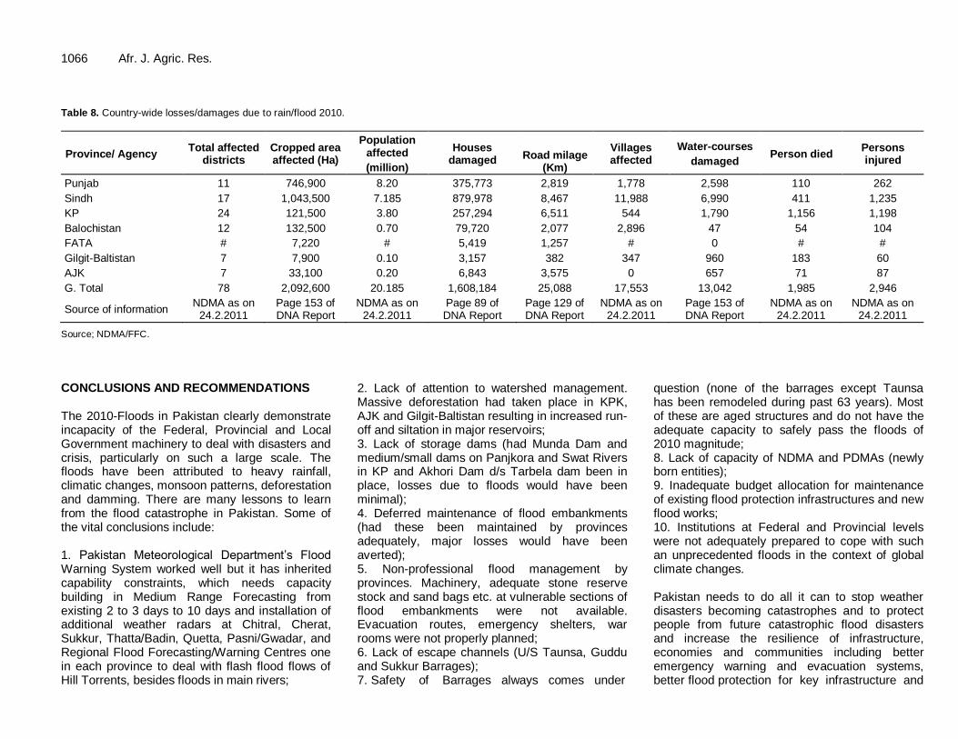
1066 Afr. J. Agric. Res. Table 8. Country-wide losses/damages due to rain/flood 2010.
Province/ Agency Total affected
districts Cropped area affected (Ha)
Population affected
(million)
Houses damaged
Road milage (Km)
Villages affected
Water-courses
damaged Person died
Persons injured
Punjab 11 746,900 8.20 375,773 2,819 1,778 2,598 110 262
Sindh 17 1,043,500 7.185 879,978 8,467 11,988 6,990 411 1,235
KP 24 121,500 3.80 257,294 6,511 544 1,790 1,156 1,198
Balochistan 12 132,500 0.70 79,720 2,077 2,896 47 54 104
FATA # 7,220 # 5,419 1,257 # 0 # #
Gilgit-Baltistan 7 7,900 0.10 3,157 382 347 960 183 60
AJK 7 33,100 0.20 6,843 3,575 0 657 71 87
G. Total 78 2,092,600 20.185 1,608,184 25,088 17,553 13,042 1,985 2,946
Source of information NDMA as on
24.2.2011 Page 153 of DNA Report
NDMA as on 24.2.2011
Page 89 of DNA Report
Page 129 of DNA Report
NDMA as on 24.2.2011
Page 153 of DNA Report
NDMA as on 24.2.2011
NDMA as on 24.2.2011
Source; NDMA/FFC.
CONCLUSIONS AND RECOMMENDATIONS The 2010-Floods in Pakistan clearly demonstrate incapacity of the Federal, Provincial and Local Government machinery to deal with disasters and crisis, particularly on such a large scale. The floods have been attributed to heavy rainfall, climatic changes, monsoon patterns, deforestation and damming. There are many lessons to learn from the flood catastrophe in Pakistan. Some of the vital conclusions include: 1. Pakistan Meteorological Department’s Flood Warning System worked well but it has inherited capability constraints, which needs capacity building in Medium Range Forecasting from existing 2 to 3 days to 10 days and installation of additional weather radars at Chitral, Cherat, Sukkur, Thatta/Badin, Quetta, Pasni/Gwadar, and Regional Flood Forecasting/Warning Centres one in each province to deal with flash flood flows of Hill Torrents, besides floods in main rivers;
2. Lack of attention to watershed management. Massive deforestation had taken place in KPK, AJK and Gilgit-Baltistan resulting in increased run-off and siltation in major reservoirs; 3. Lack of storage dams (had Munda Dam and medium/small dams on Panjkora and Swat Rivers in KP and Akhori Dam d/s Tarbela dam been in place, losses due to floods would have been minimal); 4. Deferred maintenance of flood embankments (had these been maintained by provinces adequately, major losses would have been averted); 5. Non-professional flood management by provinces. Machinery, adequate stone reserve stock and sand bags etc. at vulnerable sections of flood embankments were not available. Evacuation routes, emergency shelters, war rooms were not properly planned; 6. Lack of escape channels (U/S Taunsa, Guddu and Sukkur Barrages); 7. Safety of Barrages always comes under
question (none of the barrages except Taunsa has been remodeled during past 63 years). Most of these are aged structures and do not have the adequate capacity to safely pass the floods of 2010 magnitude; 8. Lack of capacity of NDMA and PDMAs (newly born entities); 9. Inadequate budget allocation for maintenance of existing flood protection infrastructures and new flood works; 10. Institutions at Federal and Provincial levels were not adequately prepared to cope with such an unprecedented floods in the context of global climate changes. Pakistan needs to do all it can to stop weather disasters becoming catastrophes and to protect people from future catastrophic flood disasters and increase the resilience of infrastructure, economies and communities including better emergency warning and evacuation systems, better flood protection for key infrastructure and
plans to help communities recover once the waters recede. To prevent future catastrophic flood disasters, the following recommendations are made: 1. Improvement and extension of the Flood Forecasting System to include Upper Indus above Tarbela, and Kabul River above Nowshera (telemetry system on tributaries and additional weather radars); 2. Development of flood management guidelines for Tarbela and Mangla reservoirs so as to enhance their flood mitigation role; 3. Identification of future reservoirs that would have high flood mitigation role in addition to their agriculture and hydropower benefits (Munda , small/medium dams on Panjkora and Swat Rivers and Akhori); 4. Identification of flood release channels/escape channels to desert areas/off channel storages that would provide major reduction in flood peak discharge in main rivers (d/s Taunsa and d/s Guddu and Sukkur) 5. Flood Plain Mapping/Zoning all along the Indus river and its tributaries for restricting/prohibiting by law permanent settlements in high and medium flood risk areas (provinces to enact laws); 6. Resettlement/relocation of villages in flood plains to safe areas outside the flood bunds; 7. Identification of low flood risk areas for future cities, towns and villages, industrial areas etc; 8. Rehabilitation and review the design discharge capacity of barrages on the Indus river system to enhance their safe flood discharging capacities; 9. Review and revision of the design criteria and discharge capacities of bridges/ communication infrastructure and flood protection bunds keeping in view the bench marks of 2010-floods; 10. Upgradation of the flood protection facilities/bunds that provide protection to important installations such as power stations, oil refineries, industries etc.; 11. Review of breaching sections and areas inundated as a consequence of breaches; 12. Hill Torrent Management (flood dispersion structures); and 13. Mutual support insurance system on country-wide basis to support recovery for infrastructure and affectees. ACKNOWLEDGEMENTS The support of Higher Education Commission (HEC) Pakistan and University of Engineering and Technology, Taxila (UETT) Pakistan for this research study and Federal Flood Commission (FFC) Pakistan for providing the required records is duly acknowledged. Special thanks are also due for Pakistan Meteorological Department (PMD) for providing access to data-base.
Hashmi et al. 1067 Abbreviations: ADB, Asian Development Bank; Cusec, Cubic feet per second; D/S, downstream; DNA, damage need assessment; FFC, Federal Flood Commission, Pakistan; FATA, Federally Administrated Tribal Areas; KPK, Khyber Pakhtunkhwa; NDMA, National Disaster Management Authority; PDMA, Provincial Disaster Management Authority; PMD, Pakistan Meteorological Department; RD, reduced distance; RMB, right marginal bund; U/S, upstream; WAPDA, Water and Power Development Authority, Pakistan.
REFERENCES Camorani G, Castellarin A, Brath A (2006). Effects of land-use changes
on the hydrologic response of reclamation systems. Phys. Chem. Earth, 30: 561-574
Damage Need Assessment (DNA) Report of Asian Development Bank,
Nov. (2010). Data Archive of Flood Forecasting Division, Pakistan. Data Archive of Pakistan Meteorological Department, Pakistan
European Parliament Council (2007) Directive 2007/60/Ec of the
European Parliament and of the council of 23 October 2007 on the assessment and management of flood risks http://eur-lex.europa.eu/en/index.htm.
FFC (2011). Federal Flood Commission of Pakistan, Annual Flood Report-2010.
Holling CS (1973) Resilience and stability of ecological systems. Annu
Rev Ecol Syst 4:1-24. doi: 10.1146/annurev.es.04.110173.000245. Jonkman, S.N., Vrijling, J.K. (2008) Loss of life due to floods. J Flood
Risk Manag 1(1):43-56. doi:10.1111/ j.1753-318X.2008.00006.x.
Merz B, Thieken AH, Gocht, M (2007). Flood risk mapping at the local scale: concepts and challenges. In: Begum S, Stive MJF, Hall JW (eds) Flood risk management in Europe: innovation in policy and practice. Series: Advances in natural and technological hazards
research, vol 25. Springer, Dordrecht. Ohl C, Tapsell S (2000) Flooding and human health: the dangers posed
are not always obvious. BMJ 321:1167-1168.
doi:10.1136/bmj.321.7270.1167. Records of Pakistan Meteorological Department (PMD), Pakistan
(2010). Records of Federal Flood Commission(FFC), Pakistan
Records of National Disaster Management Authority(NDMA), Pakistan.
Van Manen SE, Brinkhuis M (2005) Quantitative flood risk assessment
for Polders. Reliab Eng Syst Saf 90:229-237. doi:10.1016/j.ress.2004.10.002.
Vis, M., Klijn F, De Bruijn KM, Van Buuren M (2003) Resilience
strategies for flood risk management in the Netherlands. Int. J. River Basin Manag., 1(1): 33-44.
Wooldridge S, Kalman J, Kuczera G (2001) Parameterisation of a
simple semi-distributed model for assessing the impact of landuse on hydrologic response. J. Hydrol. (Amst), 254: 16-32. doi:10.1016/ S0022-1694(01)00489-9.