Embed Size (px)
Citation preview

2004 Water Use Efficiency Proposal - Section B Agricultural Research
Project Information Form
Applying for:
1. (Section A) Urbanor Agricultural Water UseEfficiency ImplementationProject
2. (Section B) Urban orAgricultural Research andDevelopment; FeasibilityStudies, Pilot, orDemonstration Projects;Training, Education orPublic Information;Technical Assistance
Urban Agricultural
(a) implementation of Urban Best Management Practice,#_________________________
(b) implementation of Agricultural Efficient WaterManagement Practice, #______________
(c) implementation of other projects to meet CaliforniaBay-Delta Program objectives, Targeted Benefit # orQuantifiable Objective #, if applicable ______________
(d) Specify other: ___________________
(e) research and development, feasibility studies, pilot, ordemonstration projects
(f) training, education or public information programs withstatewide application
(g) technical assistance (h) other
3. Principal applicant(Organization or affiliation):
David Slaughter, Bio. & Agricultural Engineering Dept.
University of California, Davis
4. Project Title: Ground-based Remote Sensing Technology forImproved Agricultural Water Use Efficiency in FurrowIrrigation Systems.
David Ricci, Contracts &Grants Analyst
Office of Research
University of California, Davis
Davis, CA 95616
(530) 752-9753
(530) 754-6008
5. Person authorized to sign and submitproposal and contract:
Name, title
Mailing address
Telephone
Fax.
E-mail [email protected]

David Slaughter, Professor
Bio. & Agricultural Engineering
University of California, Davis
Davis, CA 95616
(530) 752-5553
(530) 752-2640
6. Contact person (if different): Name, title.
Mailing address.
Telephone
Fax.
E-mail [email protected]
7. Grant funds requested (dollar amount): $462,340
(from Table C-1, column VI)
8. Applicant funds pledged (dollar amount): None
9.Total project costs (dollar amount):
(from Table C-1, column IV, row n )
$462,340
10. Percent of State share requested (%)
(from Table C-1)100%
11. Percent of local share as match (%)
(from Table C-1)None
12. Is your project locally cost effective?
Locally cost effective means that the benefits to an entity (in dollar terms) ofimplementing a program exceed the costs of that program within theboundaries of that entity.
(If yes, provide information that the project in addition to Bay-Deltabenefit meets one of the following conditions: broad transferablebenefits, overcome implementation barriers, or accelerateimplementation.)
(a) yes
(b) no
11. Is your project required by regulation, law or contract?If no, your project is eligible.
If yes, your project may be eligible only if there will beaccelerated implementation to fulfill a future requirementand is not currently required.
Provide a description of the regulation, law or contract and anexplanation of why the project is not currently required.
(a) yes (b) no
Automated monitoring of furrow irrigation efficiency is not currently required by law.

3 years (12/01/05 to11/30/08)8th Assembly District
5th Senate District
California's 1st District
Yolo/Solano
12. Duration of project (month/year to month/year):
13. State Assembly District where the project is to be conducted:
14. State Senate District where the project is to be conducted:
15. Congressional district(s) where the project is to be conducted:
16. County where the project is to be conducted:
17. Location of project (longitude and latitude)UC Davis(long.=-121.75, lat.=38.56)
18. How many service connections in your service area (urban)? N/A
19. How many acre-feet of water per year does your agency serve? N/A
20. Type of applicant (select one): (a) City
(b) County
(c) City and County
(d) Joint Powers Authority
(e) Public Water District
(f) Tribe
(g) Non Profit Organization
(h) University, College
(i) State Agency
(j) Federal Agency
(k) Other
(i) Investor-Owned Utility
(ii) Incorporated Mutual Water Co.
(iii) Specify __________________
21. Is applicant a disadvantagedcommunity? If ‘yes’ include annualmedian household income.
(Provide supporting documentation.)
(a) yes, ________ median household income
(b) no

Signature Page
By signing below, the official declares the following:
The truthfulness of all representations in the proposal;
The individual signing the form has the legal authority to submit the proposal on behalf of theapplicant;
There is no pending litigation that may impact the financial condition of the applicant or itsability to complete the proposed project;
The individual signing the form read and understood the conflict of interest and confidentialitysection and waives any and all rights to privacy and confidentiality of the proposal on behalf ofthe applicant;
The applicant will comply with all terms and conditions identified in this PSP if selected forfunding; and
The applicant has legal authority to enter into a contract with the State.
David Ricci, UCD Contracts & Grants AnalystSignature Name and title Date
Page 1 of 26
Ground-based Remote Sensing Technologyfor Improved Agricultural Water use Efficiency
in Furrow Irrigation Systems.
A 2004 Water use Efficiency Proposal - Section B, Agricultural Research and Development
Feasibility Study
Principal Investigators:
David Slaughter, Professor; Wesley Wallender, Professor; and Shrinivasa Upadhyaya, ProfessorBiological and Agricultural Engineering, University of California, Davis
Proposal Summary:
This proposal will study the feasibility of using ground-based remote sensing techniques tomonitor the application of water in furrow irrigation systems in order to provide a means ofsubstantially reducing water lost to deep percolation and tail water losses by automaticallycontrolling the application rate of irrigation water.
This proposal addresses the following topics found in the list of agricultural water use efficiencyprojects of interest in the 2004 Water Use Efficiency Proposal Solicitation Package
Applied research projects on specific soil, water, plant issues as related to water useefficiency
Potential benefits and costs of employing remote sensing technology to improve water useefficiency
Potential benefits and costs of improved water use practices associated with crops, cropprocessing, or land management practices affecting water use efficiency (for example rice,processing tomatoes, reduced tillage, grazing lands)
Potential benefits and costs of improved furrow irrigation
Exploration of new technologies and water management practices to improve water useefficiency
Page 2 of 26
Statement of Work, Section 1: Relevance and Importance
Furrow irrigation is the oldest and most popular method of row crop irrigation throughout theworld as well as in California. Important California row crops grown in the Sacramento - SanJoaguin Delta region such as processing tomatoes (one of the crops in the list of agriculturalprojects of interest in the proposal solicitation package) and corn are commonly irrigated withfurrow irrigation methods. The popularity of furrow irrigation is due in part because it is theirrigation method requiring the least capital investment. However, it is also the method with thelowest water application efficiency. The low water application efficiency comes from the factthat there is currently no precise or automated way to change the water discharge rate at the headof the furrow during irrigation. Control of furrow irrigation is done manually in California usingfield labor with little or no theoretical training in irrigation principles. Further, on largeCalifornia farms, farm size necessitates scheduling many irrigation events such that the waterwill reach the end of the furrow at night, a time when manual monitoring of irrigation progress isdifficult and accidental over irrigation is more common resulting in excessive amounts of waterloss at the end of the furrow as excess tail water.
The water application efficiency in furrow irrigation is suboptimal because there is no preciseway to vary discharge at the furrow inlet once irrigation starts. Varying the flow rate during afurrow irrigation event, as opposed to holding it constant or letting it vary arbitrarily, can reducewater lost to excess deep percolation and runoff. Deep percolation water infiltrates and passesbelow the root zone and is not consumed by the plant. Because water is ponded at the upstreamend of the field during the time water is spreading or advancing along the furrow, excess watermay infiltrate and lead to excess deep percolation at the upstream end. To reduce nonuniformityof infiltration, a control goal is to start with a high inflow rate and spread the water across thefield quickly such that the ponding time and hence infiltration is more uniform. The upper limitof the flow rate, however, is constrained to prevent overtopping (submerging the top of theplanting beds between furrows) and erosion. Excess deep percolation is also caused by irrigationtime in excess of that required to meet requirements at locations infiltrating the least amount ofwater (often this is at the downstream end of the field where the ponding time is least). Henceturning off the water at the appropriate time is also part of the optimal flow control requirement.
As mentioned above, precisely controlling the inflow rate not only reduces excess deeppercolation it also reduces runoff. If the high inflow rate, used to quickly advance the wateracross the field, is maintained during the entire irrigation event, runoff will occur in most cases.Runoff can be reduced to near zero by decreasing the inflow rate with time from the maximum atthe beginning to zero at the completion of irrigation.
Optimal control of the inflow rate with time (hydrograph) depends on infiltration information.Infiltration rate during an irrigation event generally decreases with ponding time and hence withdistance along the furrow but the trend can actually reverse because soils are often highlynonuniform. Infiltration rates also change from irrigation to irrigation as cultivation andantecedent soil water change the initial conditions. Infiltration information is transmitted in thetime it takes for water to advance (advance time) along the furrow. If the infiltration rate is high,advance is slow and vice versus. Hence, the time when inflow rate is programmed to decline is
Page 3 of 26
delayed and the rate of decline at the end of the irrigation may be greater. Knowing the advancetime along the field represents infiltration information that is used to control the inflow.
Theory predicts that the application of automatic feedback control methods to the discharge rateof water into the furrow, deep percolation and tail water losses during both the advance andsoaking stages could be substantially reduced. A successful application of automatic furrowirrigation control would result in considerable improvement in furrow irrigation waterapplication efficiency in California.
Clemmens (1992) reviewed a number of methods developed for feedback control of surfaceirrigation using contact-type sensors manually positioned in the furrows and found that feedbackcontrol systems did consistently better than the farm irrigators in terms of net infiltrated depthand application efficiency. Clemmens and Keats (1992) found that more precise control ofirrigation is possible by combining information from field conditions with observations of wateradvance. Hibbs et al. (1992) developed a furrow irrigation automation system utilizing anadaptive control algorithm. The performance of the automated system when compared withfurrow irrigation at a constant flowrate, produced a 74% reduction in tailwater, and 39% increasein application efficiency while decreasing cumulative infiltration by 28%. Humpherys andFisher (1995) developed a semiautomatic feedback control system for irrigation of basins andborders. A sensor at a downfield cutoff point was used to send an irrigation termination signal(via wire or infrared telemetry) to a controller at the upper end of the field. The semiautomaticcontrol provided operator convenience and reduced water and labor use. Fekersillassie andEisenhauer (2000a and 2000b) developed a model and operating criteria for feedback controlledsurge irrigation primarily based upon runoff information because of difficulties in obtainingwater advance information required for feedback control. Eisenhauer et al. (2000) conductedfield studies to evaluate the performance of the feedback control model. In this study a runoff-measuring flume was placed at a single point at the downstream end of the field where the runoffexits the field and sixteen water advance sensors were placed in eight furrows in the left and theright halves of the field at one-fourth of the field length. Data was transmitted to the controlsystem via infrared telemetry. The average deviation in effective irrigation depth was 3.0% andthe maximum deviation from the mean was 10.8%. They also found that 32% of the furrows hadnot completed water advance during the planned advance phase and 7.5% had not completedadvance after the entire irrigation. When using contact-type sensors manually positioned in thefurrows Eisenhauer et al. (2000) observed that one of the main questions was where should thesensors be placed and how many sensors were needed? They determined that spatial andtemporal variations in the infiltration rate were the most important factors in finding the optimumnumber of water advance sensors and their placements. Latimer and Reddell (1990) developedan automated system to control furrow irrigation. They sensed water advance at twopredetermined locations in the furrow and determined infiltration parameters by using a volumebalance equation that was then used in a model for management of the remainder of the irrigationevent.
During the summer of 1995, Dr. Reddell of the Texas A&M University Agricultural EngineeringDept. conducted field tests of a furrow irrigation feedback control system based upon waterarrival sensors placed in the furrows. The computed changes in water inflow were achieved bymanual adjustment of the irrigation control valves. For the first experiment of irrigation into a
Page 4 of 26
relatively dry profile a water savings of 60% (28 m3 compared to 45 m3 under normal practices)was achieved. In the second experiment, the irrigation was applied to relatively moist soil, a fewdays after a rain, 9 m3 of water was applied under the controlled discharge compared to 22 m3
under the normal practice of tail water. These field tests clearly show the advantages offeedback control of the water inflow with water application efficiencies in the range of 75 to 92percent under feedback control as compared to a range of 30 to 55 percent under the normalconstant inflow typically used in agriculture.
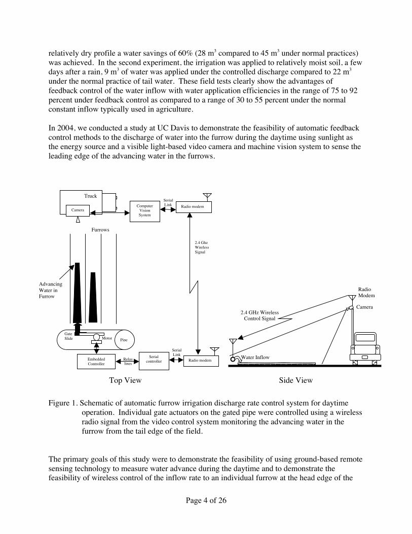
In 2004, we conducted a study at UC Davis to demonstrate the feasibility of automatic feedbackcontrol methods to the discharge of water into the furrow during the daytime using sunlight asthe energy source and a visible light-based video camera and machine vision system to sense theleading edge of the advancing water in the furrows.
Top View Side View
Figure 1. Schematic of automatic furrow irrigation discharge rate control system for daytimeoperation. Individual gate actuators on the gated pipe were controlled using a wirelessradio signal from the video control system monitoring the advancing water in thefurrow from the tail edge of the field.
The primary goals of this study were to demonstrate the feasibility of using ground-based remotesensing technology to measure water advance during the daytime and to demonstrate thefeasibility of wireless control of the inflow rate to an individual furrow at the head edge of the
Radio modem
Truck
ComputerVisionSystem
SerialLink
2.4 GhzWirelessSignal
Radio modem
SerialLinkSerial
controllerEmbeddedController
GateSlide Motor
Relaylines
Pipe
Camera
Furrows
AdvancingWater inFurrow
2.4 GHz WirelessControl Signal
RadioModem
Camera
Water Inflow

Page 5 of 26
field from the control system located at the field edge at the tail end of the field. This projectdiffered from other projects investigating irrigation feedback control where contact-type sensorsare manually positioned in the furrows. It demonstrated that ground-based remote sensing ofwater advance can be done from the field boundary. A significant advantage of field-edgeremote sensing is that it is compatible with tractor-based field operations (e.g. cultivation orchemical application) where contact-type sensors may need to be removed to avoid damagingthem before a tractor could enter the field. Furthermore, a vision-based sensor offers thepossibility of monitoring water advance over the length of the furrow with a single sensor,whereas multiple contact-type sensors must be placed in the furrow to monitor this same region.This system, demonstrated during the daytime in June 2004 at the UC Davis campus farm,captured visible images from a high mast mounted camera at the field edge. It located theleading edge of the advancing water in a selected furrow in each image. When the leading edgeof the water reached a preset shut off distance, commands were sent via a wireless radio link tothe gate controller at the other end of the field to shut the slide gate controlling inflow, Figure 1.
The general concept is that the camera moves perpendicular to the furrows along the tail edge ofthe field, monitoring the water advance in each furrow as it travels along the field boundary.Camera carriers such as tethered balloons, free flight radio controlled miniature aircraft, cable orrail transport or ground vehicle systems are possible transport methods for ground-based remotesensing of the water advance. Ultimately the carrier will be autonomous, guided by imagingalignment on row ends augmented by GPS and or other means such as buried cable, or a lasertracker with passive reflectors at row ends. On very large fields, multiple camera systems couldbe used in a mobile, self-organizing computer network to increase the update rate of feedbackinformation for the automatic furrow irrigation control system.
A similar concept, known as networked infomechanical systems (NIMS) has been developedunder a $7.5 million National Science Foundation grant to monitor a mountain stream or forestecosystem looking for subtle changes in temperature, humidity or sunlight(http://www.engineeringalum.ucla.edu/magazine/nims.asp). NIMS was developed to providesystems that are self-aware and may autonomously adapt to their environment. Based upon anovel form of mobile embedded computing that exploits infrastructure, the system allowsmonitoring of full three-dimensional environments and the physical transport of diverse sensorsand actuators. The NIMS prototype, called the Treebot due to its use within the forest canopy, isequipped with environmental sensors, a camera, a server and a wireless network link. It travelsalong a collection of steel cables, each attached to two tall trees. For example, the Treebot wassuspended between two, tall Douglas fir trees at the Wind River Canopy Crane Research Facility(http://depts.washington.edu/wrccrf/NIMS/NIMS.html). The wireless network allows the systemto transmit the data directly to computers in researchers’ offices. The system docks whennecessary to recharge its batteries, minimizing power constraints that have limited other remotewireless sensor networks in the past. Information learned about mobile sensing systems andremote wireless sensor networks from the NIMS study will be applied to our research onautomatic furrow irrigation control.
While the 2004 UC Davis system successfully demonstrated the feasibility of automaticfeedback control methods for furrow irrigation using ground-based remote sensing, the sensingsystem was limited to daytime operation. Thus there is a need to develop a ground-based remote

Page 6 of 26
sensor that can detect the leading edge of water advance in irrigated furrows at night when thesensor is located at the field edge. Electromagnetic sensing methods are ideally suited for remotesensing of water in irrigated furrows due to their non-contact nature and ability to travel longdistances quickly. In the visible portion of the electromagnetic spectrum, water at the shallowdepth typically found in furrow irrigation is essentially transparent, figure 3. Water, at thetemperatures typically found at night in an agricultural field, emits virtually no light in the visibleregion due to blackbody radiation. While moonlight or high-power light sources could beevaluated for use with the previously developed visible light sensing method; moonlight is notcontinuously available and high-power light sources are undesirable from an energy basis in amobile sensing system. Thus a more energy efficient and commercially viable nighttime watersensor is desired for this application.
Researchers have studied many different methods of detecting water, either by itself (e.g. liquidwater on the surface of a leaf) or as a component in a mixture (e.g. the moisture content of soil).Sensors are generally classified into one of two types, passive and active, based upon theirenergy requirements. A passive sensor does not require an additional energy source to measurethe parameter of interest, while an active sensor requires an excitation signal that provides thenecessary energy needed to make the measurement. For example, a standard visible light videocamera is a passive sensor when operated outdoors during the daytime because the naturalillumination is sufficient for video acquisition. However, in the dark (e.g. at nighttime on amoonless night) it becomes an active sensor because an external flash lamp is required to providethe necessary illumination. Research has shown that both passive and active sensing methodscan be used for water detection.
While it is feasible to measure soil moisture (which has different properties from surface water inirrigated furrows) using a wide range of electromagnetic energy from high-energy x-ray to lowenergy radio waves, studies have shown that infrared and microwave energy bands areparticularly advantageous for in situ measurements (Wheeler and Duncan, 1984; Upadhyaya etal., 1994). Remote sensing using satellite imaging can be used to distinguish bodies of waterfrom surrounding surface features at night using passive thermal infrared and microwaveimagery. For example, passive thermal infrared and microwave satellite imagery has been usedto develop maps of sea ice in open seawater (Gloersen et al. 1992). The image appearance of asurface feature as obtained using passive thermal infrared and microwave radiometer depends onits emissivity (which is again dependent on incidence angle, frequency and polarization of thesensor) and its physical temperature.
The appearance of objects in a thermal infrared image is based upon three fundamental laws ofphysics: Wein’s law, Kirchhoff’s law, and the Stefan-Boltzmann law. Wein’s law describes therelationship between the temperature, T, of a blackbody and the peak wavelength, λMax, ofemitted electromagnetic radiation produced due to thermal radiation:
λMax = 2897.6 µm K / T
For blackbodies in the range of temperatures normally found in an irrigated agricultural field, thepeak wavelengths emitted range from 9 to 10 µm in the far (thermal) infrared region. The

Page 7 of 26
Stefan-Boltzmann law describes the relationship between the total heat flow rate, Q, emittedfrom a blackbody of surface area A:
Q = AεσT4
where ε is the emissivity and σ is the Stefan-Boltzmann constant. Kirchoff’s law describes theemissivity, ε, of a material as the ratio of the radiant heat flow from an object made from thatmaterial to the radiant heat flow emitted from an ideal blackbody.
ε = QObject / QBlackbody
A blackbody (i.e. a perfect thermal emitter) has, by definition, an emissivity of 1. Water has ahigh emissivity (εWater = 0.96) making it a fairly good approximation of a blackbody, however theemissivity varies with the angle of observation. The emissivity is a maximum when viewedperpendicular to the water surface (i.e. as in a top view from a satellite) and remains fairlyconstant until the angle of observation is about 60 degrees from the surface normal and thenbegins to decrease (Wolfe and Zissis, 1978). Plant species have emissivities that range from 0.95to 0.98 (Gates, 1964) and soil emissivities range from 0.90 to 0.98 (Idso and Jackson, 1969),however both are affected by moisture content.
Infrared thermometers or thermal imagers (satellite or aircraft) can be used to measure anobject’s surface temperature remotely. Both of these instruments measure the amount ofradiation emitted from a surface and relate it to temperature using the three laws previouslydescribed. These methods can be used to detect crop water stress remotely by measurement ofthe crop's surface temperature. Silva et al. developed a real-time precision irrigation systembased on the crop water stress index (CWSI) derived from infrared thermometry measurements.Infrared thermometers are a simple, convenient means to determine CWSI and thus monitor thecrop water status (Idso et al. 1981; Jackson et al. 1981).
One of the unique properties of water is that it has a high specific heat capacity when comparedto most dry materials. For comparison, water at 20 oC has a specific heat capacity of4181.8 J/kg·K while dry soil has a specific heat capacity of about 800 J/kg·K. Water tends toretain heat longer and to cool more slowly than materials with lower specific heat capacities.Dry soils tend to loose and gain heat fairly rapidly, because of their lower specific heat values.In the daytime water bodies are typically cooler than nearby dry bare soil or vegetative areas dueto solar radiant heating. At night water bodies typically appear warm compared to meadows ordry bare soil, which appear cooler. Thus thermal sensors, including remote sensing using thermalimaging, can be effective in monitoring the movement of moisture in the environment. Insatellite or airborne thermal imagery, where warm objects are bright and cool objects appeardark, the appearance of water bodies and dry bare soil follow a diurnal pattern, where the wateris brighter that the surrounding soil at night and the reverse is true during the day.
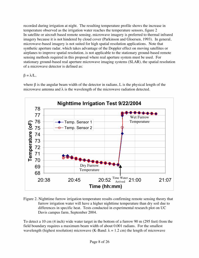
A study of nighttime furrow temperature was conducted on the UC Davis campus farm toillustrate and confirm this temperature pattern under furrow irrigation. Two temperature probeswere placed in a dry furrow about 200 feet from the tail end of the field and the temperature
Page 8 of 26
recorded during irrigation at night. The resulting temperature profile shows the increase intemperature observed as the irrigation water reaches the temperature sensors, figure 2In satellite or aircraft based remote sensing, microwave imagery is preferred to thermal infraredimagery because it is not hindered by cloud cover (Parkinson and Gloersen, 1993). In general,microwave-based imagery is not suited for high spatial resolution applications. Note thatsynthetic aperture radar, which takes advantage of the Doppler effect on moving satellites orairplanes to improve spatial resolution, is not applicable to the stationary ground-based remotesensing methods required in this proposal where real aperture system must be used. Forstationary ground-based real aperture microwave imaging systems (SLAR), the spatial resolutionof a microwave detector is defined as:
β = λ/L,
where β is the angular beam width of the detector in radians, L is the physical length of themicrowave antenna and λ is the wavelength of the microwave radiation detected.
Nighttime Irrigation Test 9/22/2004
6869707172737475767778
20:38 20:45 20:52 21:00 21:07Time (hh:mm)
Tem
per
atu
re (
oF
) Temp. Sensor 1
Temp. Sensor 2
Figure 2. Nighttime furrow irrigation temperature results confirming remote sensing theory thatfurrow irrigation water will have a higher nighttime temperature than dry soil due todifferences in specific heat. Tests conducted in experimental research plot on UCDavis campus farm, September 2004.
To detect a 10 cm (4 inch) wide water target in the bottom of a furrow 90 m (295 feet) from thefield boundary requires a maximum beam width of about 0.001 radians. For the smallestwavelength (highest resolution) microwave (K-Band: λ = 1.2 cm) the length of microwave
Time WaterArrived
Wet FurrowTemperature
Dry FurrowTemperature
Page 9 of 26
antenna required for a resolution of 0.001 radians would be 10.9 m (36 feet), which is not verypractical. In addition, microwave imaging systems are not readily available and their currentcost makes them less attractive than other water detection methods. In a ground-based remotesensing application, cloud cover is not a problem and thermal infrared imagery is preferred tomicrowave systems due to lower cost and greater availability.
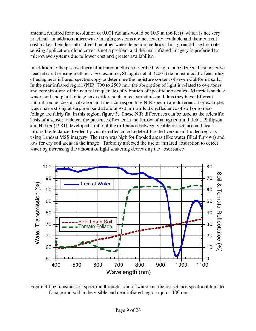
In addition to the passive thermal infrared methods described, water can be detected using activenear infrared sensing methods. For example, Slaughter et al. (2001) demonstrated the feasibilityof using near infrared spectroscopy to determine the moisture content of seven California soils.In the near infrared region (NIR: 700 to 2500 nm) the absorption of light is related to overtonesand combinations of the natural frequencies of vibration of specific molecules. Materials such aswater, soil and plant foliage have different chemical structures and thus they have differentnatural frequencies of vibration and their corresponding NIR spectra are different. For example,water has a strong absorption band at about 970 nm while the reflectance of soil or tomatofoliage are fairly flat in this region, figure 3. These NIR differences can be used as the scientificbasis of a sensor to detect the presence of water in the furrow of an agricultural field. Philipsonand Hafker (1981) developed a ratio of the difference between visible reflectance and nearinfrared reflectance divided by visible reflectance to detect flooded versus unflooded regionsusing Landsat MSS imagery. The ratio was high for flooded areas (like water filled furrows) andlow for dry soil areas in the image. Turbidity affected the use of infrared absorption to detectwater by increasing the amount of light scattering decreasing the absorbance.
60
65
70
75
80
85
90
95
100
0
10
20
30
40
50
60
70
80
400 500 600 700 800 900 1000 1100
1 cm of Water
Yolo Loam SoilTomato Foliage
Wat
er T
rans
miss
ion
(%)
Soil & Tomato Reflectance (%
)
Wavelength (nm)
Figure 3 The transmission spectrum through 1 cm of water and the reflectance spectra of tomatofoliage and soil in the visible and near infrared region up to 1100 nm.

Page 10 of 26
Measurement of soil properties using changes in the state of polarization of electromagneticwaves has been tested in remote sensing using both passive and active approaches (Egan, 1985).Polarization of a nonpolarized light source and depolarization of a polarized light source byreflection on the soil surface were measured using light sources in the visible and infrared bands.Correlations have been established between the degree of polarization or depolarization and theincidence angle at a given incident light wavelength on different soil surfaces (Coulson, 1966;Egan and Hallock, 1969). Laboratory tests have demonstrated that, when a polarized laser isreflected by a soil surface, the reflected light is depolarized. The degree of depolarizationgenerally decreases with an increase in moisture content of the soil sample (Zhang et al., 2000).The polarization technique has also been used for in-situ measurement of road surface-wetness(Itakura et al., 1982).
Objectives:
The primary objective of this proposed research is to develop non-contact sensing methods forthe remote detection of water advance in row crop furrows during nighttime furrow irrigation.We will study the feasibility of using these water detection methods as feedback sensors in theautomatic control of irrigation water in order to substantially improve water use efficiency infurrow irrigation by reducing water lost to deep percolation and tail water losses.
Specifically we will investigate the application of the following sensing methods for nighttimewater detection:
1) passive thermal infrared sensors and2) active near infrared laser-based sensors.

Page 11 of 26
Statement of Work, Section 2: Technical/Scientific Merit, Feasibility
This research will consist of two primary tasks to study the feasibility of using 1) passive thermalinfrared sensing methods, and 2) active near infrared sensing methods for the remote detection ofwater advance in row crop furrows during nighttime furrow irrigation.
Task 1: Development and Assessment of Passive Thermal Infrared Sensing Methods
The projected cost of task 1 is $324,314. Note that several of the supply and equipment itemsare common to tasks 1 and 2, and that there is some overlap in personnel activities between tasksthat result in the total cost presented in Table C1 to be lower than the sum of the projected costsof each task when they are calculated as independent research projects.
1a: A thermal infrared image acquisition and image analysis system will be designed andconstructed that is suitable for collection of ground-based remote images in an agriculturalfield. The system will be constructed from as many commercially available componentspossible, however, it is expected that some custom hardware and software componentswill need to be developed at UC Davis for this study.
1b: Compare the sensitivity of handheld point source thermal infrared sensors to low cost (i.e.uncooled) thermal imaging sensors to determine the feasibility of using uncooled thermalimaging sensors outdoors at the edge of an agricultural field to detect the presence ofwater in row crop furrows at night.One of the main research questions regarding the use of thermal imaging cameras iswhether the current technology has the required signal to noise ratio required to allowrobust differentiation of thermal differences between soil and water. Thermal imagingcameras are currently available in two formats, cooled and uncooled, with cooled camerascurrently costing two to eight times more than uncooled cameras. In addition to cost(which will likely come down over time), the other disadvantage of cooled cameras istheir higher power requirement due to the power requirements of the cooling system itself.Automatic furrow irrigation control will have more rapid acceptance if the capital costscan be kept as low as possible.Laboratory and field experiments will be designed (with appropriate statisticalexperimental design plans) and conducted to assess the thermal resolution of point sourceand imaging sensors over the range of temperatures expected in agricultural fields inCalifornia. Initial tests will be conducted in the laboratory with adjacent controlledtemperature water baths. The laboratory tests will be conducted in a dark room tosimulate nighttime conditions. The sensors will be mounted above the water surface withthe optical axis parallel to the water surface normal. The laboratory tests will allowgreater control of water temperature over a wider range of temperatures than the fieldtests. The laboratory results will be validated in the field using small experimental plotson the UC Davis campus farm. Water temperatures in the field will be controlled usingmixtures of water of different temperatures to achieve the desired temperature conditions.Actual water and soil temperatures will be determined using temperature probes andcomputerized data loggers. Image processing and classification analysis will be

Page 12 of 26
conducted to assess the sensitivity of the current thermal infrared technology in thedetection of water in row crop furrows at night.
1c: Study the effect of angle of observation (with respect to the water surface normal) on theaccuracy and precision of point source and imaging-based thermal infrared sensors.As described in section 1, the emissivity of water varies with the angle of observation,with most of the change occurring at low angles. If tethered balloons or free flight radiocontrolled miniature aircraft are used to position the sensors then the angle of observationfor most of the field will be within the range of uniform thermal emissivity. However, forcases where the detection system is placed about 4 or 5 meters above the ground at theedge of the field boundary, the angle of observation will be fairly low for most of the fieldand resulting in lower value of emissivity.Laboratory and field tests will be designed (with appropriate statistical experimentaldesign plans) and conducted to assess the affect of angle of observation on the accuracyand precision of point source and imaging-based thermal infrared sensors in determiningabsolute and relative temperature differences. Initial tests will be conducted in thelaboratory with adjacent controlled temperature water baths using a range of temperaturesexpected in agricultural fields in California. The laboratory tests will be conducted in adark room to simulate nighttime conditions. The laboratory results will be validated in thefield using small experimental plots on the UC Davis campus farm. Water temperatures inthe field will be controlled using mixtures of water of different temperatures to achieve thedesired temperature conditions. Actual water and soil temperatures will be determinedusing temperature probes and computerized data loggers to validate non-contacttemperature measurements.
1d: Characterize the level of soil/water surface thermal contrast in a row crop agriculturalfield at night over a range of environmental conditions throughout the normal processingtomato irrigation season found in northern California.The success of remote thermal infrared detection depends upon adequate contrast betweenthe objects of interest (soil and water in this case). There are several factors that can causea thermal infrared apparent temperature difference. Of relevance to this study are:temperature, emissivity, and surface geometry. The emissivity is constant for a givenmaterial and moisture content. The surface geometry of soil can be affected by soiltexture, tillage practices, moisture content, and compaction (wheel row versus non-wheelrow). The surface geometry of water in irrigated furrows can be affected by wind andorganic material floating in the water. Temperature is a function of the weather and afunction of the time of the year and the time of the day or night.Laboratory and field tests will be designed (with appropriate statistical experimentaldesign plans) and conducted to assess the range of thermal contrast expected for a range oftemperatures, emissivities, and surface geometries. A range of soil types common toCalifornia will be obtained from the UC Davis Land, Air and Water ResourcesDepartment. The soils will be conditioned with a range of moisture and compaction andsimulated tillage treatments and their actual temperatures and apparent infraredtemperatures determined in the laboratory. Field studies will be conducted to characterizethe range of actual soil and water temperatures found at night throughout the normal

Page 13 of 26
processing tomato irrigation season (March through September) on the UC Davis campusfarm.
1e: Conduct alignment tests to align a laser rangefinder with the thermal infrared sensors inorder to characterize the accuracy of distance measurements from the field boundary to theleading edge of water advance using laser range finding methods at night.To provide the necessary feedback information for an automatic irrigation control system,the distance from the leading edge of water advance to the inflow at the pipe gate must bedetermined once the leading edge has been detected. Because the system must operate atnight, the normal visual landmarks (e.g. row spacing) using in the daytime remote sensingsystem are unavailable. In this study a targetless commercial laser range finder will beused to determine the distance from the edge of the field to the leading edge of wateradvance detected by the infrared sensor. A custom mounting system will be designed andconstructed to allow the physical alignment of the laser range finder with the optical axisof the thermal infrared sensors. Field studies will be designed (with appropriate statisticalexperimental design plans) and conducted to assess the accuracy of distancemeasurements from the field boundary to the leading edge of water advance using laserrange finding methods at night. Actual distances will be determined using field tapemeasures or with reflective laser targets once their accuracy has been validated.In the final year of the project, field studies will be conducted to document the expectedgains in water application efficiency using remote thermal infrared sensors for feedbackcontrol of furrow irrigation. Field studies will be designed (with appropriate statisticalexperimental design plans) to measure both the furrow inflow rate (using a flow meter) aswell as the rate of water advance (using the remote thermal infrared sensors). This datawill be applied to existing furrow irrigation models to predict the impact on reductions indeep percolation and tail water losses using remote thermal infrared sensors.
Task 2: Development and Assessment of Active Near Infrared Sensing Methods
The projected cost of task 2 is $306,867 .
2a: A near infrared pulsed laser system and imaging detection system, with a peak wavelengthnear the 970 nm water absorption band will be designed and assembled from as manycommercially available components possible, however, it is expected that some customhardware and software components will need to be developed at UC Davis for this study.The system will be designed with industry standard safety interlocks and will use arotating mirror system to allow laser scanning of the furrow.
2b: Study the effects of angle of polarization on the ability to distinguish the leading edge ofwater advance from dry soil in the furrow at night.It is known that light reflected from the surface of water is highly polarized while thatreflected from dry soil surfaces is almost unpolarized. Experiments will be designed (withappropriate statistical experimental design plans) and conducted to determine the effect ofangle of polarization of a linearly polarized laser light source on the ability to distinguishthe leading edge of water advance from dry soil in the furrow at night. Preliminary tests
Page 14 of 26
will be conducted in a dark laboratory room and will be validated in the field if thepreliminary results show positive results.
2c: Study the effect of angle of observation (with respect to the water surface normal) on theability to use the optical absorbance at a single wavelength to the leading edge of wateradvance in the furrow at night.The spectral data shown in figure 3 demonstrate that 970 nm light will be stronglyabsorbed by water (3 inches of water will absorb 98% of the light at 970 nm) and reflectedby soil or plant foliage. Thus a 970 nm laser spot should be visible (using a near infraredcamera) when pointed at the soil or on crop foliage, but should disappear when pointed ata few inches of water. Similar (but opposite in value of change) to the change in theemissivity with the angle of incidence, the reflectivity of light from the surface of wateralso varies with the angle of incidence. Thus, as the laser light scans down the furrow,both the reflectivity and the distance to the target changes, resulting in a possible changein reflectance. Laboratory and field experiments will be designed (with appropriatestatistical experimental design plans) and conducted to assess feasibility of using a singlewavelength near the 970 nm water absorption band to detect the difference between drysoil and water in furrows during irrigation at various angles of incidence. If preliminaryresults indicate that a single wavelength has inferior performance, a second laser at adifferent wavelength will be added to use as a reference to adjust for the effects of angle ofincidence.
2d: Conduct alignment tests to align a laser rangefinder with the near infrared sensors in orderto characterize the accuracy of distance measurements from the field boundary to theleading edge of water advance using laser range finding methods at night.Similar to the thermal infrared case, it is necessary to determine the distance from theleading edge of water advance to the inflow at the pipe gate for adequate feedback control.A custom mounting system will be designed and constructed to allow the physicalalignment of the laser range finder with the optical axis of the near infrared sensors. Fieldstudies will be designed (with appropriate statistical experimental design plans) andconducted to assess the accuracy of distance measurements from the field boundary to theleading edge of water advance using laser range finding methods at night. Actualdistances will be determined using field tape measures or with reflective laser targets oncetheir accuracy has been validated.In the final year of this project, field studies will be conducted to document the expectedgains in water application efficiency using remote near infrared sensors for feedbackcontrol of furrow irrigation. Field studies will be designed (with appropriate statisticalexperimental design plans) to measure both the furrow inflow rate (using a flow meter) aswell as the rate of water advance (using the remote near infrared sensors). This data willbe applied to existing furrow irrigation models to predict the impact on reductions in deeppercolation and tail water losses using remote near infrared sensors.
2e: Analyze data & compare the performance of the passive infrared method of Task 1 to theactive method of Task 2 by applying remote sensing accuracies to existing furrowirrigation models to determine the impact on reductions in deep percolation and tail waterlosses. Write final report.
Page 15 of 26
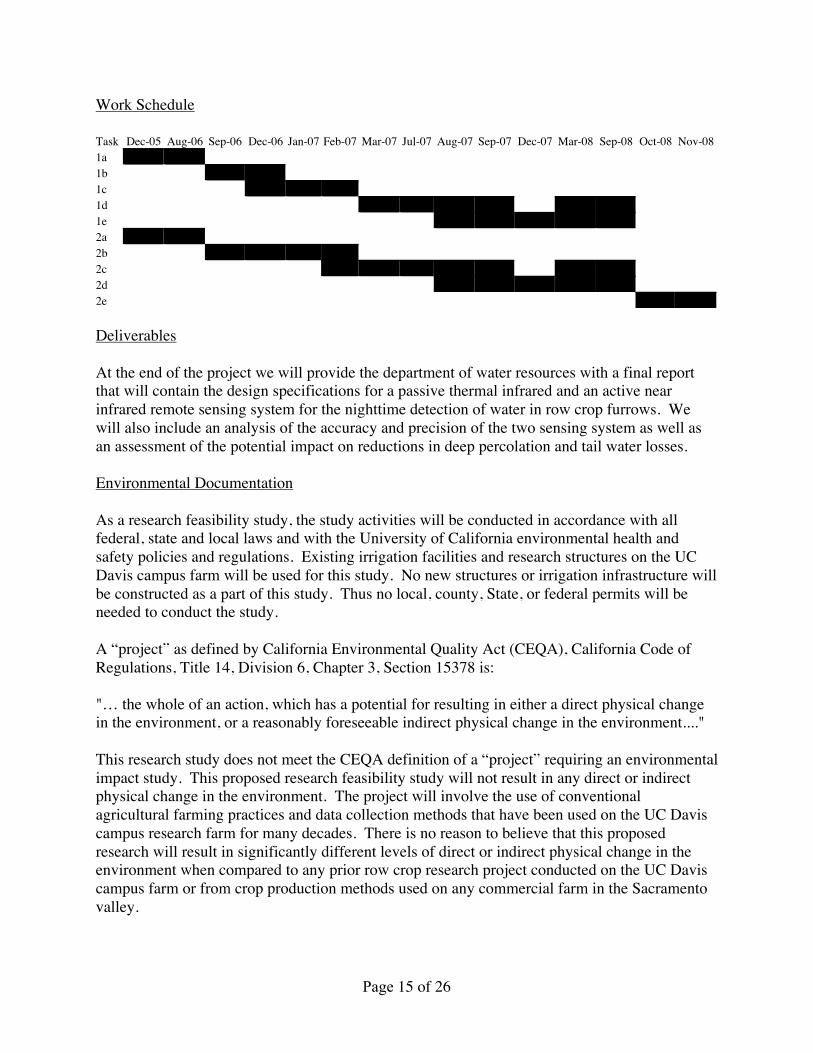
Work Schedule
Task Dec-05 Aug-06 Sep-06 Dec-06 Jan-07 Feb-07 Mar-07 Jul-07 Aug-07 Sep-07 Dec-07 Mar-08 Sep-08 Oct-08 Nov-081a1b1c1d1e2a2b2c2d2e
Deliverables
At the end of the project we will provide the department of water resources with a final reportthat will contain the design specifications for a passive thermal infrared and an active nearinfrared remote sensing system for the nighttime detection of water in row crop furrows. Wewill also include an analysis of the accuracy and precision of the two sensing system as well asan assessment of the potential impact on reductions in deep percolation and tail water losses.
Environmental Documentation
As a research feasibility study, the study activities will be conducted in accordance with allfederal, state and local laws and with the University of California environmental health andsafety policies and regulations. Existing irrigation facilities and research structures on the UCDavis campus farm will be used for this study. No new structures or irrigation infrastructure willbe constructed as a part of this study. Thus no local, county, State, or federal permits will beneeded to conduct the study.
A “project” as defined by California Environmental Quality Act (CEQA), California Code ofRegulations, Title 14, Division 6, Chapter 3, Section 15378 is:
"… the whole of an action, which has a potential for resulting in either a direct physical changein the environment, or a reasonably foreseeable indirect physical change in the environment...."
This research study does not meet the CEQA definition of a “project” requiring an environmentalimpact study. This proposed research feasibility study will not result in any direct or indirectphysical change in the environment. The project will involve the use of conventionalagricultural farming practices and data collection methods that have been used on the UC Daviscampus research farm for many decades. There is no reason to believe that this proposedresearch will result in significantly different levels of direct or indirect physical change in theenvironment when compared to any prior row crop research project conducted on the UC Daviscampus farm or from crop production methods used on any commercial farm in the Sacramentovalley.

Page 16 of 26
Statement of Work, Section 3: Monitoring and Assessment
• Explanation of the monitoring methodologies that will be used and the project monitoringdata that will be collected to assess project results.
Monitoring and assessment are an integral part of a properly conducted research project.Standard laboratory practices found in most research laboratories will be used in this project.These include the use of written laboratory notebooks where all aspects of the research aredocumented including: hypotheses and engineering design concepts, experimental (statisticaland procedural) plans and engineering design alternatives, final engineering design plans,data logs and experimental observations. Project principal investigators will be in charge ofmonitoring project methodologies to verify that the research is being conducted according toaccepted research practices, that appropriate experimental designs are utilized, that the data iscollected in an accurate and organized manner, and that all appropriate safety procedures arebeing followed.
Assessment of research results will be done using SAS and other appropriate computersoftware packages according to accepted statistical analysis techniques. Standard confidencelimits (i.e. 95% and 99%), and levels of significance (i.e., 5% and1%) will be applied in theassessment of results. Bayesian classification techniques will be applied where appropriateand paired error analysis will be conducted to assess accuracy of paired distancemeasurements.
• Explanation of how the above data will be used to evaluate success in relation to projectgoals and objectives.
For remote sensing objectives, project performance will be assessed in terms of classificationaccuracy rates in distinguishing water from soil and in terms of the distance error betweenthe actual distance to the leading edge of water advance and that predicted by the remotesensing system. For overall water efficiency objectives, project performance will beevaluated by applying remote sensing accuracies to existing furrow irrigation models todetermine the impact on reductions in deep percolation and tail water losses.
• Description of how pre-project conditions and data baselines will be determined, the basicassumptions being used, and the anticipated accuracy of the data to be produced.
Where applicable, the pre-project conditions and data baselines will be assessed through theuse of untreated controls in the experimental designs of affected research experiments. Basicassumptions will be based upon known physical properties of soil, water, plant materials, andknowledge of standard agricultural practices for crop production, including typical irrigationpractices, as required in the design of experiments and remote sensing systems. It isexpected that temperature data recorded in this study will be accurate to 1 oC, with theexception of the uncooled thermal imaging system which may be slightly higher. It isexpected that the actual distance measurements in the field will be accurate to within +/-0.5feet and that the predicted distances from the remote sensing systems will be accurate towithin +/- 5 feet.

Page 17 of 26
• Description of how external factors such as changes in weather, cropping programs, or socialconditions will be taken into account.
External factors such as weather and cultural practices may have a significant impact of theperformance of the remote sensing system and so these factors have been incorporated intothe experimental designs developed to assess system performance. Aspects of the researchthat are affected by weather will be repeated in multiple years (within the time constraints ofthe proposal call) to give a more robust assessment of their impact.
• Information about how the data and other information will be handled, stored, and reportedand made accessible to DWR and others.
Data and other research information will be recorded in laboratory notebooks and stored onuniversity computer systems. Important information will be made available to DWR andothers in reports and journal publications and through UC cooperative extension sponsoredfield days and grower meetings.
• Estimated costs associated with the implementation of the monitoring and evaluation plan.
As an integral part of the research, monitoring and evaluation costs are included in theproject budget on page 21 .

Page 18 of 26
Qualifications of the Applicants and Cooperators
Resumes for professors Slaughter, Wallender, and Upadhyaya are attached to the end of theproposal.
Professor Slaughter is an expert in instrumentation, sensor development and robotics. He hasconducted considerable research on the use of optics and machine vision in agriculturalapplications and has a US patent on a machine vision guidance system for use in precisioncultivation of processing tomatoes and other California row crops. He developed the opticalinspection system used at all California processing tomato inspection stations. This system isused to determine the color quality of all processing tomatoes grown in California. Togetherwith professor Upadhyaya, he has developed a near infrared sensing method for thedetermination of moisture for California soils and they are currently working on an infraredmethod for determining soil nitrogen content.
Professor Wallender is an expert in hydrology, irrigation engineering, modeling and thestatistical description of irrigation system performance including drainage reduction throughirrigation system control. He has considerable experience in geographic information systemsand in the use of remote sensing for regional water and land management applications.
Professor Upadhyaya is an expert in precision agriculture technology including GPS and GIS, intillage, soil dynamics and the modeling of biological systems. He has considerable expertise inthe design and development of soil property and crop yield sensors. Together with professorSlaughter, he has developed a near infrared sensing method for the determination of moisture forCalifornia soils and they are currently working on an infrared method for determining soilnitrogen content.
Outreach, Community Involvement and Acceptance
The University of California has an excellent system for the dissemination of agriculturalresearch results through the outreach programs offered by its cooperative extension specialistsand farm advisors. This study will fully utilize these programs and will disseminate the researchfindings through local grower meetings, and on-campus field days organized by cooperativeextension specialists and farm advisors. Research findings will also be presented at national andinternational conferences on precision agriculture. In addition, research findings will bepublished and made available to the public through printed sources such as CaliforniaAgriculture and the Transactions of the American Society of Agricultural Engineers.
Innovation
This proposed project seeks to develop state-of-the-art ground-based remote sensing technologyfor the remote detection of water advance in row crop furrows during nighttime furrowirrigation. These innovative water detection methods will be used as feedback sensors in theautomatic control of irrigation water in order to substantially improve water use efficiency infurrow irrigation by reducing water lost to deep percolation and tail water losses. Because

Page 19 of 26
furrow irrigation is the most popular method of row crop irrigation throughout California thesenew sensing technologies could be used to substantially improve the water use efficiency ifapplied to furrow irrigation in all of California.
Benefits and Costs
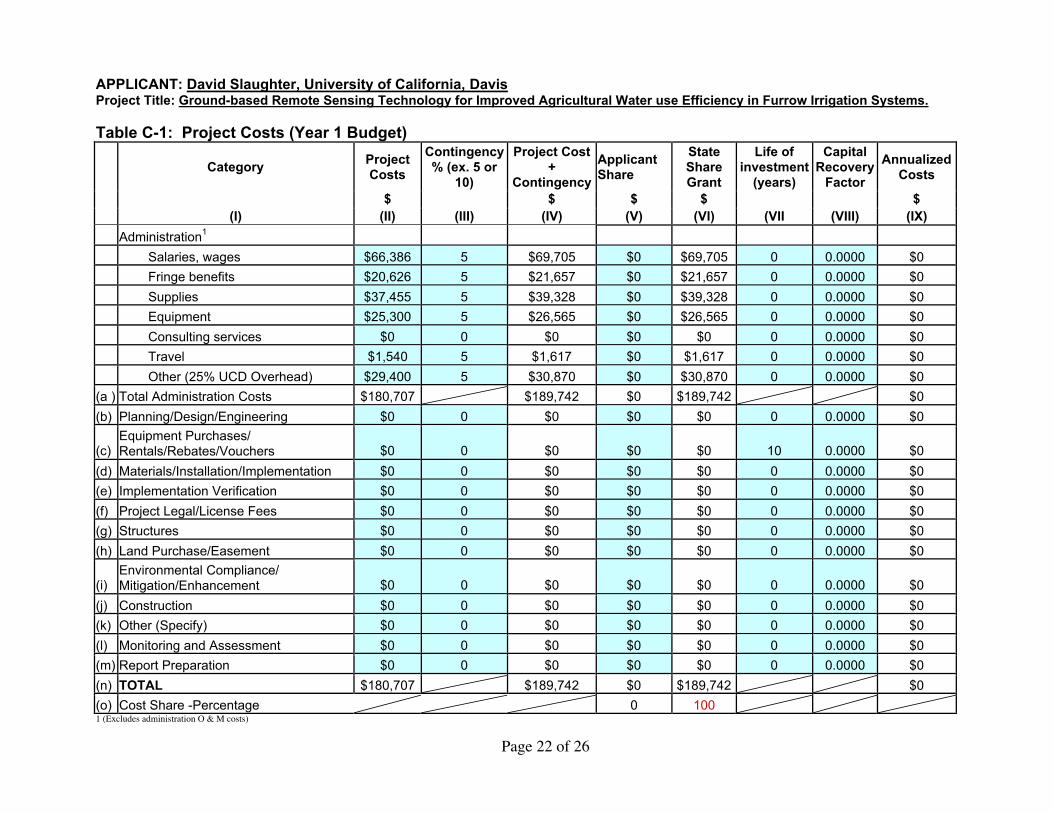
Project costs (both in total and by year) are shown in Table C-1 on the following four pages.
Labor costs
Support is requested in the amount of $209,282 ($66,386 in year 1, $69,705 in year 2 and$73,191 in year 3) for a 100% time Post Doctoral Scholar; 50% time academic year, 100% timesummer Graduate Student Researcher III; 25% time academic year, 100% time summerUndergraduate Student Asst. IV; and 10% time Development Engineer to conduct the proposedresearch. Fringe benefits are calculated at 30% for the Post Doctoral Scholar, 3% for theGraduate Student Researcher, 3% for the Undergraduate Student Asst. IV, and 32% for theDevelopment Engineer. Graduate fee remission of $26,503 ($8,407 in year 1, $8827 in year 2,and $9269 in year 3) is requested in support of the Graduate Student Researcher.
Equipment costs
Funds of $25,300 for a thermal infrared imaging system and a near infrared laser range finder arerequested in year 1.
Supply costs
Support is requested in the amount of $56,160 ($37,455 in year 1, $9,125 in year 2, and $9,580in year 3) for supplies and materials including: lasers, polarizing and interference filters &optical components and mounting fixtures, IR temperature sensors and data loggers, lenses, IRsafety goggles, NIR vision system (camera & computer), optical encoders, software, electronicand mechanical fabrication supplies, irrigation field support, field supplies and publication costs.
Travel costs
Support is requested in the about of $6,855 ($1,540 in year 1, $1,617 in year 2, and $3,698 inyear 3) for travel by UCD project researchers to conduct experiments and present results atscientific meetings.
Indirect costs
Indirect costs are $77,704 for this three-year project, which is calculated as 25% of the UC Davismodified direct costs (exclusive of equipment and fee remission).
Page 20 of 26
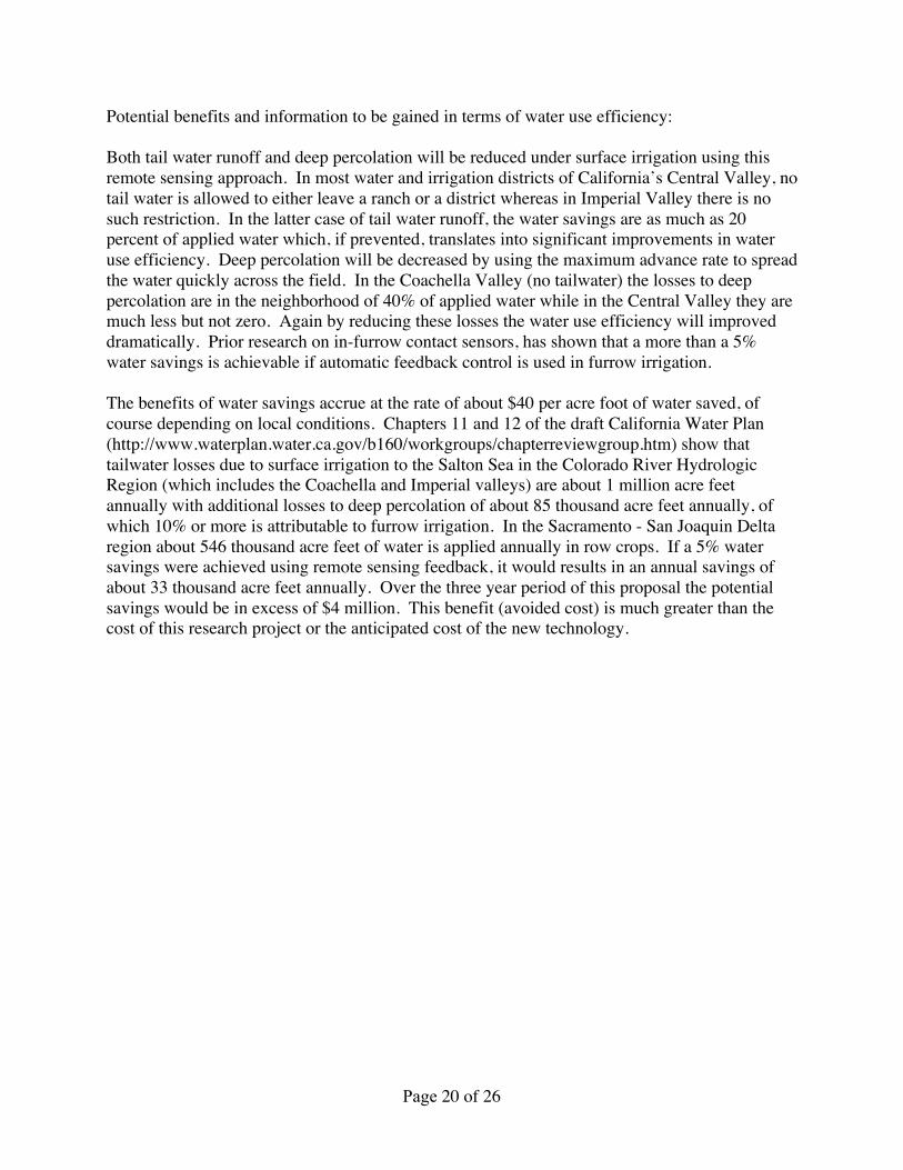
Potential benefits and information to be gained in terms of water use efficiency:
Both tail water runoff and deep percolation will be reduced under surface irrigation using thisremote sensing approach. In most water and irrigation districts of California’s Central Valley, notail water is allowed to either leave a ranch or a district whereas in Imperial Valley there is nosuch restriction. In the latter case of tail water runoff, the water savings are as much as 20percent of applied water which, if prevented, translates into significant improvements in wateruse efficiency. Deep percolation will be decreased by using the maximum advance rate to spreadthe water quickly across the field. In the Coachella Valley (no tailwater) the losses to deeppercolation are in the neighborhood of 40% of applied water while in the Central Valley they aremuch less but not zero. Again by reducing these losses the water use efficiency will improveddramatically. Prior research on in-furrow contact sensors, has shown that a more than a 5%water savings is achievable if automatic feedback control is used in furrow irrigation.
The benefits of water savings accrue at the rate of about $40 per acre foot of water saved, ofcourse depending on local conditions. Chapters 11 and 12 of the draft California Water Plan(http://www.waterplan.water.ca.gov/b160/workgroups/chapterreviewgroup.htm) show thattailwater losses due to surface irrigation to the Salton Sea in the Colorado River HydrologicRegion (which includes the Coachella and Imperial valleys) are about 1 million acre feetannually with additional losses to deep percolation of about 85 thousand acre feet annually, ofwhich 10% or more is attributable to furrow irrigation. In the Sacramento - San Joaquin Deltaregion about 546 thousand acre feet of water is applied annually in row crops. If a 5% watersavings were achieved using remote sensing feedback, it would results in an annual savings ofabout 33 thousand acre feet annually. Over the three year period of this proposal the potentialsavings would be in excess of $4 million. This benefit (avoided cost) is much greater than thecost of this research project or the anticipated cost of the new technology.

Page 21 of 26
PROJECT IMPLEMENTATION COSTS TABLESAPPLICANT: David Slaughter, University of California, DavisProject Title: Ground-based Remote Sensing Technology for Improved Agricultural Water use Efficiency in Furrow Irrigation Systems.Table C-1: Project Costs (Total Budget)
Category
ProjectCosts
Contingency% (ex. 5 or
10)
Project Cost+
Contingency
ApplicantShare
StateShareGrant
Life ofinvestment
(years)
CapitalRecovery
Factor
AnnualizedCosts
$ $ $ $ $ (I) (II) (III) (IV) (V) (VI) (VII (VIII) (IX)
Administration1
Salaries, wages $209,282 5 $219,746 $0 $219,746 0 0.0000 $0
Fringe benefits $65,023 5 $68,274 $0 $68,274 0 0.0000 $0
Supplies $56,160 5 $58,968 $0 $58,968 0 0.0000 $0
Equipment $25,300 5 $26,565 $0 $26,565 0 0.0000 $0
Consulting services $0 0 $0 $0 $0 0 0.0000 $0
Travel $6,855 5 $7,198 $0 $7,198 0 0.0000 $0
Other (25% UCD Overhead) $77,704 5 $81,589 $0 $81,589 0 0.0000 $0
(a ) Total Administration Costs $440,324 $462,340 $0 $462,340 $0
(b) Planning/Design/Engineering $0 0 $0 $0 $0 0 0.0000 $0
(c)Equipment Purchases/Rentals/Rebates/Vouchers $0 0 $0 $0 $0 10 0.0000 $0
(d) Materials/Installation/Implementation $0 0 $0 $0 $0 0 0.0000 $0
(e) Implementation Verification $0 0 $0 $0 $0 0 0.0000 $0
(f) Project Legal/License Fees $0 0 $0 $0 $0 0 0.0000 $0
(g) Structures $0 0 $0 $0 $0 0 0.0000 $0
(h) Land Purchase/Easement $0 0 $0 $0 $0 0 0.0000 $0
(i)Environmental Compliance/Mitigation/Enhancement $0 0 $0 $0 $0 0 0.0000 $0
(j) Construction $0 0 $0 $0 $0 0 0.0000 $0
(k) Other (Specify) $0 0 $0 $0 $0 0 0.0000 $0
(l) Monitoring and Assessment $0 0 $0 $0 $0 0 0.0000 $0
(m) Report Preparation $0 0 $0 $0 $0 0 0.0000 $0
(n) TOTAL $440,324 $462,340 $0 $462,340 $0
(o) Cost Share -Percentage 0 100 1 (Excludes administration O & M costs)
Page 22 of 26
APPLICANT: David Slaughter, University of California, DavisProject Title: Ground-based Remote Sensing Technology for Improved Agricultural Water use Efficiency in Furrow Irrigation Systems.
Table C-1: Project Costs (Year 1 Budget)
Category
ProjectCosts
Contingency% (ex. 5 or
10)
Project Cost+
Contingency
ApplicantShare
StateShareGrant
Life ofinvestment
(years)
CapitalRecovery
Factor
AnnualizedCosts
$ $ $ $ $ (I) (II) (III) (IV) (V) (VI) (VII (VIII) (IX)
Administration1
Salaries, wages $66,386 5 $69,705 $0 $69,705 0 0.0000 $0
Fringe benefits $20,626 5 $21,657 $0 $21,657 0 0.0000 $0
Supplies $37,455 5 $39,328 $0 $39,328 0 0.0000 $0
Equipment $25,300 5 $26,565 $0 $26,565 0 0.0000 $0
Consulting services $0 0 $0 $0 $0 0 0.0000 $0
Travel $1,540 5 $1,617 $0 $1,617 0 0.0000 $0
Other (25% UCD Overhead) $29,400 5 $30,870 $0 $30,870 0 0.0000 $0
(a ) Total Administration Costs $180,707 $189,742 $0 $189,742 $0
(b) Planning/Design/Engineering $0 0 $0 $0 $0 0 0.0000 $0
(c)Equipment Purchases/Rentals/Rebates/Vouchers $0 0 $0 $0 $0 10 0.0000 $0
(d) Materials/Installation/Implementation $0 0 $0 $0 $0 0 0.0000 $0
(e) Implementation Verification $0 0 $0 $0 $0 0 0.0000 $0
(f) Project Legal/License Fees $0 0 $0 $0 $0 0 0.0000 $0
(g) Structures $0 0 $0 $0 $0 0 0.0000 $0
(h) Land Purchase/Easement $0 0 $0 $0 $0 0 0.0000 $0
(i)Environmental Compliance/Mitigation/Enhancement $0 0 $0 $0 $0 0 0.0000 $0
(j) Construction $0 0 $0 $0 $0 0 0.0000 $0
(k) Other (Specify) $0 0 $0 $0 $0 0 0.0000 $0
(l) Monitoring and Assessment $0 0 $0 $0 $0 0 0.0000 $0
(m) Report Preparation $0 0 $0 $0 $0 0 0.0000 $0
(n) TOTAL $180,707 $189,742 $0 $189,742 $0
(o) Cost Share -Percentage 0 100 1 (Excludes administration O & M costs)

Page 23 of 26
APPLICANT: David Slaughter, University of California, DavisProject Title: Ground-based Remote Sensing Technology for Improved Agricultural Water use Efficiency in Furrow Irrigation Systems.
Table C-1: Project Costs (Year 2 Budget)
Category
ProjectCosts
Contingency% (ex. 5 or
10)
Project Cost+
Contingency
ApplicantShare
StateShareGrant
Life ofinvestment
(years)
CapitalRecovery
Factor
AnnualizedCosts
$ $ $ $ $ (I) (II) (III) (IV) (V) (VI) (VII (VIII) (IX)
Administration1
Salaries, wages $69,705 5 $73,190 $0 $73,190 0 0.0000 $0
Fringe benefits $21,657 5 $22,740 $0 $22,740 0 0.0000 $0
Supplies $9,125 5 $9,581 $0 $9,581 0 0.0000 $0
Equipment $0 5 $0 $0 $0 0 0.0000 $0
Consulting services $0 0 $0 $0 $0 0 0.0000 $0
Travel $1,617 5 $1,698 $0 $1,698 0 0.0000 $0
Other (25% UCD Overhead) $23,319 5 $24,485 $0 $24,485 0 0.0000 $0
(a ) Total Administration Costs $125,423 $131,694 $0 $131,694 $0
(b) Planning/Design/Engineering $0 0 $0 $0 $0 0 0.0000 $0
(c)Equipment Purchases/Rentals/Rebates/Vouchers $0 0 $0 $0 $0 10 0.0000 $0
(d) Materials/Installation/Implementation $0 0 $0 $0 $0 0 0.0000 $0
(e) Implementation Verification $0 0 $0 $0 $0 0 0.0000 $0
(f) Project Legal/License Fees $0 0 $0 $0 $0 0 0.0000 $0
(g) Structures $0 0 $0 $0 $0 0 0.0000 $0
(h) Land Purchase/Easement $0 0 $0 $0 $0 0 0.0000 $0
(i)Environmental Compliance/Mitigation/Enhancement $0 0 $0 $0 $0 0 0.0000 $0
(j) Construction $0 0 $0 $0 $0 0 0.0000 $0
(k) Other (Specify) $0 0 $0 $0 $0 0 0.0000 $0
(l) Monitoring and Assessment $0 0 $0 $0 $0 0 0.0000 $0
(m) Report Preparation $0 0 $0 $0 $0 0 0.0000 $0
(n) TOTAL $125,423 $131,694 $0 $131,694 $0
(o) Cost Share -Percentage 0 100 1 (Excludes administration O & M costs)

Page 24 of 26
APPLICANT: David Slaughter, University of California, DavisProject Title: Ground-based Remote Sensing Technology for Improved Agricultural Water use Efficiency in Furrow Irrigation Systems.
Table C-1: Project Costs (Year 3 Budget)
Category
ProjectCosts
Contingency% (ex. 5 or
10)
Project Cost+
Contingency
ApplicantShare
StateShareGrant
Life ofinvestment
(years)
CapitalRecovery
Factor
AnnualizedCosts
$ $ $ $ $ (I) (II) (III) (IV) (V) (VI) (VII (VIII) (IX)
Administration1
Salaries, wages $73,191 5 $76,851 $0 $76,851 0 0.0000 $0
Fringe benefits $22,740 5 $23,877 $0 $23,877 0 0.0000 $0
Supplies $9,580 5 $10,059 $0 $10,059 0 0.0000 $0
Equipment $0 5 $0 $0 $0 0 0.0000 $0
Consulting services $0 0 $0 $0 $0 0 0.0000 $0
Travel $3,698 5 $3,883 $0 $3,883 0 0.0000 $0
Other (25% UCD Overhead) $24,985 5 $26,234 $0 $26,234 0 0.0000 $0
(a ) Total Administration Costs $134,194 $140,904 $0 $140,904 $0
(b) Planning/Design/Engineering $0 0 $0 $0 $0 0 0.0000 $0
(c)Equipment Purchases/Rentals/Rebates/Vouchers $0 0 $0 $0 $0 10 0.0000 $0
(d) Materials/Installation/Implementation $0 0 $0 $0 $0 0 0.0000 $0
(e) Implementation Verification $0 0 $0 $0 $0 0 0.0000 $0
(f) Project Legal/License Fees $0 0 $0 $0 $0 0 0.0000 $0
(g) Structures $0 0 $0 $0 $0 0 0.0000 $0
(h) Land Purchase/Easement $0 0 $0 $0 $0 0 0.0000 $0
(i)Environmental Compliance/Mitigation/Enhancement $0 0 $0 $0 $0 0 0.0000 $0
(j) Construction $0 0 $0 $0 $0 0 0.0000 $0
(k) Other (Specify) $0 0 $0 $0 $0 0 0.0000 $0
(l) Monitoring and Assessment $0 0 $0 $0 $0 0 0.0000 $0
(m) Report Preparation $0 0 $0 $0 $0 0 0.0000 $0
(n) TOTAL $134,194 $140,904 $0 $140,904 $0
(o) Cost Share -Percentage 0 100 1 (Excludes administration O & M costs)

Page 25 of 26
ReferencesClemmens, A.J. 1992. Feedback-Control Of Basin-Irrigation System. J. Irrig. & Drain. Div.,
ASCE 118 (3): 480-497.Clemmens, A. J., and J. B. Keats. 1992. Bayesian inference for feedback-control II: Surface
irrigation example. J. Irrig. & Drain. Div., ASCE 118(3): 416-432.Coulson, K. L. 1966. Effects of reflection properties of natural surfaces in aerial reconnaissance.
Applied Optics 5(6): 905- 917.Egan, W. G. 1985. Photometry and Polarization in Remote Sensing. New York, N.Y.: Elsevier
Science Publishing Co.Egan,W. G., and H. B. Hallock. 1969. Coherence-polarization phenomena in remote sensing.
Proc. IEEE (April): 621-628.Eisenhauer, D.E., D. Fekersillassie, A. Boldt. 2000. Feedback-Controlled Surge Irrigation: III.
Field Experiments. Trans. of the ASAE. Vol. 43(6): 1643-1649Fekersillassie, D., and D.E. Eisenhauer. 2000a. Feedback-Controlled Surge Irrigation: I. Model
Development. Trans. of the ASAE. Vol. 43(6): 1621-1630.Fekersillassie, D., and D.E. Eisenhauer. 2000b. Feedback-Controlled Surge Irrigation: II.
Operating Criteria. Trans. of the ASAE. Vol. 43(6): 1631-1641.Gates, D.M. 1964. Characteristics of soil and vegetated surfaces to reflected and emitted
radiation. In Proc. 3rd. Int. Symp. on Remote Sensing of the Env. Environmental ResearchInst. of Michigan. Ann Arbor, Michigan.
Gloersen, P., W.J. Campbell, D.J. Cavalieri, J.C. Comiso, C.L. Parkinson, H.J. Zwally. 1992.Arctic and Antarctic sea ice, 1978-1987: Satellite Passive-Microwave Observations andAnalysis. NASA SP-511, 290 pages. Washington, D.C.
Hibbs, R. A., L. G. James, and R. P. Cavalieri. 1992. A furrow irrigation automation systemutilizing adaptive control. Trans. of the ASAE 35(3): 1063-1067.
Humpherys, A. S., and H. D. Fisher. 1995. Water sensor feedback control system for surfaceirrigation. Trans. of the ASAE 11(1): 61-65.
Idso, S.B., and R.D. Jackson. 1969. Comparison of Two Methods for Determining InfraredEmittance of Bare Soils. J. of Applied Meteorology. 8: 168-169.
Idso, S.B., Jackson, R.D., Pinter, P.J., Jr., Reginato, R.J. E Hatfield, J.L., 1981. Normalizing thestress-degree-day parameter for environmental variability, Agric. Meteorol., 24:45-55.
Itakura,Y., S. Tsutsumi, and T. Takehana. 1982. Optical sensor for measurement of road-surfacewetness based on the polarized reflection flux. Optical Soc. Am. J. 72: 17-66.
Jackson, R.D., Idso, S.B., Reginato, R.J. E Pinter, P.J., 1981. Canopy temperature as a cropwater stress indicator. Water Resour. Res., 17: 1133-1138.
Latimer, E. A., and D. L. Reddell. 1990. Components for an advance rate feedback irrigationsystem (ARFIS). Trans. of the ASAE 33(4): 1162-1170.
Parkinson, C.L. and Gloersen, P. 1993. Global Sea Ice Coverage, in Atlas of Satellite
Page 26 of 26
Observations Related to Global Change, Cambridge University Press, pp 371-384.Philipson, W.R., and W.R. Hafker. 1981. Manual versus Digital Landsat Analysis for
Delineating River Flooding. Photogrammetric Engineering and Remote Sensing. Vol.47:1351-1356.
Silva, H.R., D.J. Hills, J.W. Rumsey, S. Upadhyaya, D. Slaughter, and U. Rosa. SubmittedManuscript. Real-time Irrigation Scheduling using Infrared Thermometry. ASAEmanuscript SW-05381-2004, St. Joseph, MI.
Slaughter, D.C., M.G. Pelletier, and S.K. Upadhyaya. 2001. Sensing Soil Moisture using NIRSpectroscopy. Applied Engineering in Ag. 17(2):241-247.
Upadhyaya, S. K., W. J. Chancellor, J. V. Perumpral, R. L. Schafer, W. R. Gill, and G. E.Vandenberg. 1994. Advances in Soil Dynamics, Vol 1. St. Joseph, Mich.: ASAE.
Wheeler, P. A., and G. L. Duncan. 1984. Measuring soil moisture electromagnetically.Agricultural Engineering 84(9): 12.
Wolfe, W.L., and G.L. Zissis. 1978. The Infrared Handbook. Office of Naval Research,Washington D.C. 1718 pages.
Zhang, N., Y. Sun, N. Wang, M. Wang, T. Loughin. 2000. Effectiveness of a polarized laserlight for measuring soil moisture content. Trans. of ASAE 43(6): 1963-1968
David C. SlaughterProfessor
Biological and Agricultural EngineeringUniversity of California, Davis 95616
(530) 752-5553
Education1987 - Ph.D. awarded in Agricultural Engineering, University of Florida. Dissertation title
"Color Vision for Robotic Orange Harvesting".1984 - M.S. awarded in Biological and Agricultural Engineering, North Carolina State
University.1982 - B.S. awarded with high honors in Agricultural Engineering, University of California,
Davis.
Employment1996 - Present Associate Professor, Department of Biological and Agricultural Engineering,
University of California, Davis.1990 - 1996 Assistant Professor, Department of Biological and Agricultural Engineering,
University of California, Davis.1987-1990 Research Scientist, Instrumentation and Sensing Laboratory, USDA -
Agricultural Research Service, Beltsville, MD.1984-1987 Research Scientist, Insect Attractants, Behavior, and Basic Biology Research
Laboratory, USDA - Agricultural Research Service, Gainesville, FL.
Honors and Awards1998 - American Society of Agricultural Engineers Paper Award for publication titled
“Precision band spraying with machine vision guidance and adjustable yaw nozzles”.1997 - American Society of Agricultural Engineers Paper Award for publication titled
“Machine vision detection of early split pistachio nuts”.1990 - American Society of Agricultural Engineers Paper Award for publication titled
"Discriminating fruit for robotic harvest using color in natural outdoor scenes."1989 - USDA Certificate of Merit.1986 - USDA Certificate of Merit and Quality Increase.1984 - USDA Engineering Traineeship1982 - American Society of Engineers Student Honor Award.1981 - Robert Row Owen Academic Scholarship.1979 - Ben L. Hagglund Academic Scholarship.
Professional and Honorary SocietiesAlpha Epsilon - Agricultural Engineering Honor Society.American Society of Agricultural Engineers.Council for Near Infrared Spectroscopy.Phi Kappa Phi - National Interdisciplinary Honor Society.Pi Mu Epsilon - National Honorary Mathematics Fraternity.Sigma Xi - Scientific Research SocietyTau Beta Pi - National Engineering Honor Society

D.C. SlaughterPage 2
PatentsSlaughter, D.C., R. Curley, P. Chen, and D.K. Giles. 1995. Robotic Cultivator. U.S. Patent
No. 5,442,552.Giles, D. K., and D. C. Slaughter. 1996. Adjustable spray system and assembly method. U.S.
Patent No. 5,544,813. August 13, 1996. (Similar Canadian Patent Pending). Licensed toCapstan Ag Systems, Inc., Topeka, KS.
Selected PublicationsGiles, D.K., and D.C. Slaughter. 1997. Precision band spraying with machine-vision guidance
and adjustable yaw nozzles. Transactions of the ASAE 40(1):29-36.Tian, L., D.C. Slaughter, and R.F. Norris. 1997. Outdoor field machine vision identification of
tomato seedlings for automated weed control. Transactions of the ASAE 40(6):1761-1768.
Li, M., D.C. Slaughter, and J.F. Thompson. 1997. Optical chlorophyll sensing system forbanana ripening. Postharvest Biology and Technology 12:273-283.
Sebben, E., D.C. Slaughter, and R.P. Singh. 1998. Optical assessment of corn oil deteriorationduring frying. J. of Food Processing and Preservation 22(4):265-282.
Tian, L.F., and D.C. Slaughter. 1998. Environmentally adaptive segmentation algorithm foroutdoor image segmentation. Computers and Electronics in Agriculture. 21:153-168.
Ehsani, M.R., S.K. Upadhyaya, D. Slaughter, S. Shafii, and M. Pelletier. 1999. A NIRtechnique for rapid determination of soil mineral nitrogen. Precision Agriculture.1(2):217-234.
Slaughter, D.C., C.G. Cavaletto, L.D. Gautz, and R.E. Paull, 1999. Non-destructivedetermination of soluble solids in papayas using near infrared spectroscopy.
Slaughter, D.C., M.G. Pelletier, and S.K. Upadhyaya. 2001. Sensing soil moisture using NIRspectroscopy. Applied Engineering in Ag. 17(2): 241–247
Ehsani, M. R., S. K. Upadhyaya, W. R. Fawcett, L. V. Protsailo, and D. Slaughter. 2001.Feasibility of detecting soil nitrate content using a mid–infrared technique. Trans. of theASAE. Vol. 44(6): 1931–1940 .
Slaughter, D.C., J.F. Thompson, and E.S. Tan. 2003. Nondestructive determination of totaland soluble solids in fresh prune using near infrared spectroscopy. Postharvest Biol.Tech. 28 (3): 437-444.
Slaughter, D.C., and J.A. Abbott. 2004. Analysis of Fruits and Vegetables. In Near-InfraredSpectroscopy in Agriculture. Agronomy Monograph No. 44. Am. Soc. of Agronomy,Crop Sci. Soc. of Am. Soil Sci. Soc. of Am. Madison, WI, USA.
Downey, D., D.K. Giles and D.C. Slaughter. 2004. Mapping weeds using DGPS and groundbased vision identification. California Agriculture. 58(4):218-221.
M. Nielsen, H. J. Andersen, D. C. Slaughter, D. K. Giles 2004. Detecting leaf features forautomatic weed control using trinocular stereo vision. Proc. 7th International Conferenceon Precision Agriculture and Other Precision Resources Management. Minneapolis.
Haff, R.P., and D.C. Slaughter. 2004. Real-time x-ray inspection of wheat for infestation bythe granary weevil, Sitophilus Granarius (L.). Trans. of the ASAE. Vol. 47(2): 531-537.
Giles, D.C. Slaughter, D. Downey, J.C. Brevis-Acuna, W.T. Lanini. 2004. Application designfor machine vision guided selective spraying of weeds in high value crops. Aspects ofApplied Biology. 71(1): 75-81.
1
Curriculum Vitae
WESLEY W. WALLENDERProfessor of Hydrology and Engineering
Departments of Land, Air and Water Resources (Hydrology Program) andBiological and Agricultural Engineering
University of California, Davis, California 95616530.752.0688 phone 530.752.05262 fax
[email protected] emailenthusiasm.ucdavis.edu web and ftp site
EDUCATION AND REGISTRATIONPh.D. Utah State University, Engineering, June 1982.M.S. University of California Davis, Water Science, June 1978B.S. Utah State University, Agricultural and Irrigation Engineering, September 1981B.S. Oregon State University, Agricultural Engineering Technology, June 1976EIT Engineer-in-Training Exam, May 1979PE Professional Engineer, California, 1987
WORK EXPERIENCE1982-present. Assistant-82-88, Associate-88-92 and Full-Professor-92-present, University of
California Davis. Research includes modeling and measurement of precipitation- and irrigation-drivenwatersheds from submeter to kilometer scales. Specific subject matter interest includes water, energy andchemical transport for sustainable agroecosystems. Teach undergraduate courses in fluid mechanics, GISand spatial analysis, and irrigation system design and graduate courses in continuum mechanics as well assurface irrigation hydraulics. Funding in excess of $6 million supporting the completion of 30 graduatestudent theses. More than 110 refereed journal articles and book chapters.
1992-3. Director, University of California Salinity/Drainage Research Program. Administered thedevelopment, interpretation, and dissemination of research knowledge addressing critical environmentalproblems on salinity, drainage, selenium, and other toxic elements in the San Joaquin Valley. Initiated along term study on the sustainability of irrigated agroecosystems within environmental constraints.
1980-2. Consultant to Keller Engineering, Logan, UT. Measured and analyzed mine wastewaterdisposal. Conducted infiltration tests to design pressurized irrigation systems.
1987-present. Registered Profession Engineering Consultant. Advise watershed entities inCalifornia. Advice and consulting to governments of France, Egypt, Oman, Mexico, Morocco, China,Brazil, and India and to the International Rice Research Institute (Philippines) and the International WaterManagement Institute (Sri Lanka).
PROFESSIONAL, SCIENTIFIC, HONORARY SOCIETIES AND AWARDSAmerican Geophysical Union, American Society of Agricultural Engineers, American Society of CivilEngineersWho's Who Among Students in American Universities and Colleges, Phi Kappa Phi, Sigma Xi, AlphaZeta, Tau Beta Pi, Blue KeyWho's Who in California, 1998Who's Who in Engineering Education, 2002External Reviewer (3), Ph.D. Dissertation, Indian Institute of TechnologyAmerican Society of Civil Engineers, Best Practices Paper Award, 2002.American Society of Civil Engineers, Best Research Paper Award, 2003.American Society of Agricultural Engineers, Technical Reviewer Special Recognition, 2001, 2002Distinguished Alumnus Award, Utah State University, College of Engineering (BIE), 2004
MEMBERSHIP ON COMMITTEES AND EDITORIAL BOARDSEditor, Soil and Water Division, American Society of Agricultural Engineers, 2004-presentAssociate Editor, Soil and Water Division, American Society of Agricultural Engineers, Developed and
implemented procedures for an electronic journal, 1991-present
2
Member, Advisory Board, International Journal of Water Resources Engineering, 1991-presentMember, Editorial Board, Irrigation Science, 1994-presentMember, Editorial Board, Brazilian Journal of Irrigation and Drainage, 2002-presentMember, Technical Advisory Committee on Forest Geology, State of California Mining and Geology
Board, 2002-presentMember, Challenge Program Consortium, Global Challenge Program on Food and Water, Consultative
Group on International Agricultural Research, 2001-2Member, Integrated Basin Water Management Systems (Research) Workgroup, Global Challenge Program
on Food and Water, Consultative Group on International Agricultural Research, 2001-2
RECENT REFEREED PUBLICATIONS99. Wallender, W.W. and M.E. Grismer. 2002. Irrigation hydrology-Crossing scales. J. of Irrigation and
Drainage Engineering ASCE 128(4):203-211.100. Kumar, M., N.S. Raghuwanshi, R. Singh, W.W. Wallender, and W.O. Pruitt. 2002. Estimating
evapotranspiration using artificial neural networks. J. of Irrigation and Drainage EngineeringASCE 128(4):223-233.
101. Young, C.A. and W. W. Wallender. 2002. Spatially distributed irrigation hydrology: water balance.Transactions of the American Society of Agricultural Engineer 45(3):609-618.
102. Zalom, F. G., M. N. Oliver, W. W. Wallender, I. Werner, B. W. Wilson, W. H. Krueger, B. T.Angermann, L. A. Deanovic, T. S. Kimball, J. D. Henderson, G. H. Oliveira, and P. Osterli. 2002.Monitoring and mitigating offsite movement of dormant spray pesticides from Californiaorchards. Acta Horticulturae. 592:729-735.
103. Angermann, T., W.W. Wallender, B.W. Wilson, I. Werner, D.E. Hinton, M.N. Oliver, F. G. Zalom,J.D. Henderson, G.H. Oliveira, L.A. Deanovic, P. Osterli, W. Krueger. 2002. Runoff fromorchard floors -- micro-plot field experiments and modeling. Journal of Hydrology265(2002):178-194.
104. Tarboton, K.C., W.W. Wallender and N.S. Raghuwanshi. 2002. 2-D Saturated-unsaturated zoneirrigation and drainage model: part I theory. Transactions of the American Society of AgriculturalEngineer 45(5):1353-1363.
105. Tarboton, K.C., N.S. Raghuwanshi and W.W. Wallender. 2002. 2-D Saturated-unsaturated zoneirrigation and drainage model: part II Sensitivity analysis. Transactions of the American Society ofAgricultural Engineer 45(5):1365-1373.
106. Wallender, W.W., J. Rhoades, M. Weinberg, S. Lee and C. Uptain. 2002. Irrigated land retirement.Irrigation and Drainage Systems 16:311-326.
107. Buyuktas, D. and W.W. Wallender. 2004. Dispersion in spatially periodic porous media. Heat andMass Transfer Research Journal 40 (2004):261-270.
108. Joyce, Brian, W. W. Wallender, T. Angermann, B.W. Wilson, I. Werner, M.N. Oliver, F.G.Zalom, and J.D. Henderson. 2004. Using infiltration enhancement and soil watermanagement to reduce Diazinon in runoff. Journal of the American Water ResourcesAssociation. August: 1063 – 1070.
109. Sivakumar, B., W.W. Wallender, C.E. Puente, and M.N. Islam. 2004. Streamflowdisaggregation: a nonlinear deterministic approach. Nonlinear Processes in Geophysics.11: 383-392
110. Vrugt, J.A., G. Schoups, J.W. Hopmans, C.A. Young, W.W. Wallender, T.A. Harter and W.Bouten. 2004. Inverse modeling of large-scale distributed vadose zone properties usingglobal optimization. Water Resources Research, Vol. 40: 1-20.
111. Purkey, D.R. W.W. Wallender, G.E. Fogg, and B. Sivakumar. 2004. Describing near surface,transient flow processes in unconfined aquifers below irrigated lands: model application in thewestern San Joaquin valley, California. Journal of Irrigation and Drainage Engineering 130:451-459.
112. Werner, I., F.G. Zalom, M.N. Oliver, L.A. Deanovic, T.S. Kimball, J.D. Henderson, B.W. Wilson,W. Krueger, and W.W. Wallender. 2004. Toxicity of stormwater runoff after dormant sprayapplication in a French prune orchard (Glenn county, California, USA): temporal patterns and theeffect of ground covers. Environmental Toxicology and Chemistry 23(11):2719-2726.
1
SHRINIVASA K. UPADHYAYA
Professor, Biological and Agricultural Engineering Department
EDUCATION:Ph.D. (1979) Agr. Eng., Cornell University, Ithaca, New YorkM.Sc. (1975) Agr. Eng., University of Manitoba, Winnipeg, Manitoba, CanadaB.Tech.(Hons)(1972) Agr. Eng., IIT, Kharagpur, West Bengal, India
RESEARCH INTEREST:Precision farming or SSCM, Sensor development, Instrumentation, GPS, GIS, Soildynamics, Soil compaction and Infiltration, Machinery design, Variability and mapping.
WORK EXPERIENCE:July 1992 to Present Professor, Dept. of Bio. and Agr. Eng. Dept., UC Davis.July 1987 - June 1992 Associate Professor, Dept. Bio.and Agr. Eng. Dept., UC Davis.Sept. 1983 - June 1987 Assistant Professor, Dept. Bio. and Agr. Eng. Dept., UC Davis.Sept. 1981 - Aug. 1983 Assistant Professor, Dept. Agri. Eng., Univ. of Del., Newark, DEJan. 1979 - Aug. 1981 Research Associate, Dept. Agr. Eng., Cornell University, Ithaca, NY.
PATENT: 1. Hydro-Pneumatic Seed Singulation for Plant Propagules US Patent 4917029. 2. Method and apparatus for ultra precise GPS based mapping of seeds or vegetation
during planting – Patent No: US 6516271B2.3. Upadhyaya, S. K., M. Ehsani, and M. L. Mattson. 2003. Method and apparatus forultra precise GPS-based mapping of seeds or vegetation during planting. US patentNo. 6,553, 312 B2.4. Upadhyaya, S. K. and P. Andrade. 2004. Development of a soil compactionprofile senor. US Patent No. 6,834,550.
HONORS AND AWARDSSoil Dynamics Award, Tiberias, Israel, 1997American Society of Agricultural Engineers Certificate of Appreciation, 1995American Society of Agricultural Engineers Paper Award, 1995JSPS Fellowship for Research in JAPAN, 1993
PROFESSIONAL AFFIALTION:1) Member, American Society of Agricultural Engineers (ASAE)2) Associate Editor of Journal of Precision Agriculture.3) Associate editor of the Transaction of the ASAE.4) California representative for the NCR-180, Site Specific Crop ManagementCommittee.
RECENT RELEVANT PUBLICATIONS:Sakai, K., T. Kobayashi, M. Takai, and S. K. Upadhyaya. 1994. Neural network mapping to
obtain 2D distributed field information—application to spatially varied infiltration data.Journal Faculty of Agriculture, Hokkaido University 66(1):63-68.
Upadhyaya, S. K., W. J. Chancellor, J. V. Perumpral, R. L. Schafer, W. R. Gill, and G. E.VandenBerg (Editors). 1994. Advances in Soil Dynamics, Vol. 1. American Society ofAgricultural Engineers Monograph Number 12. 313 pages.
Upadhyaya, S. K., K. Sakai, and J. L. Glancey. 1995. Instrumentation for in-field measurement
2
of soil crust strength. Transactions of the ASAE (American Society of AgriculturalEngineers) 38(1):39-44.
Fattah, H. A., and S. K. Upadhyaya. 1996. Effect of soil crust and soil compaction on infiltrationin a Yolo loam soil. Transactions of the ASAE (American Society of AgriculturalEngineers) 39(1):79-84.
Liu, W., S. K. Upadhyaya, T. Kataoka, and S. Shibusawa. 1996. Development of a texture/soilcompaction sensor. Proceedings of the Third International Conference in PrecisionAgriculture, Minneapolis, MN. pp. 617-630.
Upadhyaya, S. K., J. Jafari Far, S. Shafii, and H. A. Fattah. 1997. Crust-breaking deviceimproves water infiltration into furrows. California Agriculture 51(5):21-23.
S. K. Upadhyaya and N. S. Raghuwanshi. 1999. A semi-empirical equation for cumulativeinfiltration in furrow irrigations systems. J. Irr.and Drainage Eng. 125(4): 173-178.
Pelletier, M. and Upadhyaya, S. K. 1999. Development of a tomato yield monitor. Computersand Electronics in Agriculture. 23:103-117.
Josiah, M., T. Shikanai, U. A. Rosa, M. Koller. 1999. Mapping infiltration variability in a tomatoproduction system. ASAE Paper No.: 99-1146. ASAE, St. Joseph, MI 49083.
Koller, M., S. K. Upadhyaya, U. A. Rosa, and M. Josiah. 1999. Application of remote sensing ina tomato production system. ASAE Paper No.: 99-1135. ASAE, St. Joseph, MI 49083.
Koller, M., S. K. Upadhyaya, and U. A. Rosa. 2000. Neural network analysis of remote sensingdata in crop production. ASAE Paper 001096, ASAE St. Joseph, MI 49085.
Slaughter, D. C., M. G. Pelletier, and S. K. Upadhyaya. 2000. Sensing soil moisture using NIRspectroscopy. Applied Engineering in Agriculture.
Upadhyaya, S. K., W. J. Chancellor, J. V. Perumpral, R. L. Schafer, W. R. Gill, and G. E.VandenBerg (Editors). 2000. Advances in Soil Dynamics, Vol. II. American Society ofAgricultural Engineers Monograph, ASAE, St. Joseph, MI 49085. 294 pp.
Upadhyaya, S.K., K. P. Lancas, A. G. Santos-Filho, and N. S. Raghuwanshi. 2001. Evaluation ofone-pass tillage equipment versus conventional tillage system. Cal. Ag. 55(5):44-47.
Josaih, M. N., S.K. Upadhyaya, U. Rosa, P. Andrade, and M. Mattson. 2001. Mapping fieldvariability in infiltration rate and evapotranspiration in a tomato production system.ASAE paper Number 011017.
Andrade, P., J. Aguera, S. K. Upadhyaya, B. M. Jenkins, U. A. Rosa, and M. Josiah. 2001.Evaluation of a dielectric based moisture and salinity sensor in-situ applications. ASAEPaper 011010.
Andrade, P., S. K. Upadhyaya, B. Jenkins, and A.G.S. Filho. 2002. Evaluation of UC DavisCompaction Profile Sensor. ASAE Paper. 021185. ASAE, St. Joseph, MI 49085.
Abidine, A, B. Heidman, S. K. Upadhyaya, and S. K. Upadhyaya. 2004. Application of RTKGPS based auto-guidance system in agricultural production. California Agriculture.58(1):44-47.
Ehsani, M. R., S. K. Upadhyaya, and M. L. Mattson. 2004. Seed location mapping using RTKGPS. Trans. ASAE 47(3):909-914.
Josaih,M, S. K. Upadhyaya, and U. A. Rosa. 2004. The relationship between variability in cropyield and variability in soil physical characteristics. Proceedings of the First InternationalConference on Emerging Technologies in Agricultural and Food Engineering. P26-32.