Embed Size (px)
Citation preview

1301:7-9-13 Page 1
1301:7-9-13 Petroleum UST Corrective Action.
(A) Purpose and scope.
For the purpose of prescribing rules in accordance with division (A) of section 3737.88 and
division (b) of section 3737.882 of the Revised Code, the fire marshal hereby adopts this rule to
establish release reporting and corrective action requirements for underground storage tanks
containing petroleum products. This rule is adopted by the fire marshal in accordance with
Chapter 119 of the Revised Code and shall not be considered a part of the Ohio State Fire Code.
(B) Applicability.
(1) For releases reported on or after the effective date of this rule, owners and operators shall conduct
corrective action in accordance with this rule.
(2) For releases reported prior to the effective date of this rule, owners and operators may elect to
conduct corrective action in accordance with this rule by submitting a letter to the fire marshal
stating their election to conduct corrective actions in accordance with this rule.
(3) Owners and operators conducting corrective actions in accordance with OAC 1301:7-9-13
(effective date September 1, 1992), may continue to conduct corrective actions in accordance
with that version until September 1, 2005. Thereafter, owners and operators shall conduct
corrective actions in accordance with this rule.
(4) Owners and operators conducting corrective actions in accordance with OAC 1301:7-9-13
(effective date March 31, 1999), may continue to conduct corrective actions in accordance with
that version until March 1, 2006. Thereafter, owners and operators shall conduct corrective
actions in accordance with this rule.
(5) Owners and operators may request an extension of time pursuant to paragraph (Q) of this rule to
continue corrective actions under a previous version of this rule where good cause exists as
determined by the fire marshal. The fire marshal may grant, modify or deny any extension request
at his sole discretion.
(C) Definitions.
(1) “Action levels” means non-site-specific concentrations for chemical(s) of concern that are
protective of human health utilized during the tier 1 source investigation and delineation
process specified in paragraphs (J)(2) and (J)(3) of this rule.
(2) “Adjacent property” means a property or properties whose borders are contiguous or partially
contiguous with that of an UST site, or would be contiguous or partially contiguous with that
of an UST site but are separated by a street, road or other public thoroughfare.
(3) “Chemical(s) of concern” means the chemical or specific constituents of the petroleum
released that are identified for evaluation during the corrective action process.
(4) “Delineation levels” means non-site specific concentrations of chemical(s) of concern that are
designed to determine the most likely distribution of chemical(s) of concern in soil and
ground water.

1301:7-9-13 Page 2
(5) “Drinking Water Source Protection Area” means the surface and subsurface area surrounding
a public water supply well(s) supplying a community or non-transient, non-community public
water system which will provide water from an aquifer to the well(s) within five years as
delineated or endorsed by the Ohio Environmental Protection Agency under Ohio’s Wellhead
Protection and Source Water Assessment and Protection Programs.
(6) “Engineering controls” means physical modifications, (e.g., slurry walls, capping, vapor
controls, point of use water treatment) that are recorded in a deed restriction or an
environmental covenant, for the purposes of reducing or eliminating the potential for
exposure to a chemical(s) of concern.
(7) “Environmental media” includes, but is not limited to air, soil, ground water and surface
water.
(8) “Exposure assessment” means the qualitative or quantitative determination or estimation of
the magnitude, frequency, duration and route of exposure between a source area and a
receptor.
(9) “Exposure pathway” means a mechanism by which an individual or population may be
exposed to a chemical(s) of concern originating from an UST site. Each exposure pathway
includes a source or release from a source, a point of exposure, and an exposure route. If the
point of exposure is not at the source, a transport medium (e.g., air or water) also is included.
(10) “Exposure route” means the manner in which a chemical(s) of concern may come into
contact with a receptor (e.g., ingestion, inhalation, dermal contact).
(11) “Free product” means a separate liquid hydrocarbon phase that has a measured thickness of
greater than one one-hundredth of a foot.
(12) “Ground water” means water underlying an UST site in a saturated zone that:
(a) Is capable of yielding a minimum of one and one-half gallons of water within eight hours
of purging; and
(b) Has an in situ hydraulic conductivity greater than 5.0 x 10⁻⁶ centimeters per second.
(13) “Institutional controls” means the restriction on use or access (e.g., engineering controls,
environmental covenant, deed or zoning restrictions) to an UST site to eliminate or minimize
potential exposure to a chemical(s) of concern.
(14) “Immediate Corrective Action” means the course of action to mitigate fire, explosion, vapor
and safety hazards, including immediate or short-term abatement or containment measures to
prevent the spread of a release.
(15) “Interim Response Action” means the course of action taken prior to implementation of a
remedial action to reduce further migration of chemicals of concern in their vapor, dissolved,
or liquid phase, to reduce or eliminate the concentration of chemical(s) of concern at a source
area(s) and/or in soil requiring treatment, or to otherwise eliminate exposure pathways.
Interim response actions are not immediate corrective actions or remedial actions. Examples
of interim response actions include, but are not limited to, over-excavation of a former UST
1301:7-9-13 Page 3
area, and short-term dual-phase extraction in a source area.
(16) “Natural attenuation” means the reduction in the concentration(s) of chemicals of concern in
environmental media due to a combination of one or more naturally occurring physical,
chemical or biological processes (e.g., diffusion, dispersion, absorption, chemical degradation
and biodegradation).
(17) “Non-residential land use” means land use that does not meet the criteria for residential land
use. Non-residential land use includes, but is not limited to, commercial and industrial land
use.
(18) “Overfill” is a release that occurs when an UST is filled beyond its capacity, resulting in a
discharge of the regulated substance to the environment.
(19) “Petroleum contaminated soil” means soil that contains chemical(s) of concern that exceed
one or more of the re-use levels set forth in paragraph (D) of rule 1301:7-9-16 of the
Administrative Code.
(20) “Physical discovery” means:
(a) The presence of free product discovered during removal of any portion of an UST
system, in an excavation on an UST site or on a property nearby an UST site;
(b) The discovery of petroleum product vapors within or along building foundations or other
subsurface manmade structures such as building foundations, basements, pedestrian
tunnels, utility vaults, sewer lines or in a drinking water well located on an UST site or on
property nearby an UST site;
(c) The presence of free product in a monitoring or observation well located on an UST site
or on property nearby an UST site;
(d) The presence of petroleum products observed on a surface water body located on an UST
site or on property nearby an UST site suspected to have arisen from a release from that
UST system;
(e) Laboratory analytical results which are above action levels set forth in paragraph (J) from
a study or survey of an UST site or on property nearby other than from a site check
conducted in accordance with paragraph (F)(3) of this rule or a Tier 1 Source
Investigation conducted in accordance with paragraph (H)(1) of this rule; or
(f) The presence of free product discovered in an UST secondary containment system, other
than a spill bucket, on an UST site.
(21) “Point(s) of demonstration” means a location(s) selected between the source area(s) and the
potential point(s) of exposure where concentrations of chemical(s) of concern must be at or
below a determined target level in environmental media that is protective of human health
and the environment at the point of exposure.
(22) “Point(s) of exposure” means the point(s) at which a receptor may come in contact with a
chemical(s) of concern originating from an UST site.
1301:7-9-13 Page 4
(23) “Reasonably anticipated future use” means future use of a UST site that can be predicted with
a reasonably high degree of certainty given historical use, current use, and local government
planning and zoning.
(24) “Receptors” means aquatic life populations in a surface water body or person(s) that are or
may be exposed to chemical(s) of concern from the release.
(25) “Release” means:
(a) Any spilling, leaking, emitting, discharging, escaping, leaching or disposing of a
petroleum product from an UST system into the ground water, a surface water body,
subsurface soil or otherwise into the environment;
(b) Any spilling, leaking, emitting, discharging, escaping, or disposal of a petroleum product
into ground water, a surface water body, subsurface soil or otherwise into the
environment while transferring or attempting to transfer petroleum products into an UST
system; or
(c) Chemical(s) of concern in subsurface soil or ground water on an UST site found in
concentrations above the action levels specified in paragraph (J) of this rule, during
activities conducted pursuant to OAC 1301:7-9-12 and 1301:7-9-13, and confirmed
through laboratory analysis of samples from an UST site.
(26) “Residential land use” means land use where the current or intended use includes, but is not
limited to, housing (single and multiple dwellings), educational facilities, day care,
agricultural land, correctional facilities, custodial care or long term health care.
(27) “Saturated zone" means a part or layer of the earth's crust, excluding the capillary zone, in
which all voids are filled with water.
(28) “Site conceptual exposure model” means the integrated representation of the complete and
potentially complete exposure pathways at a UST site.
(29) “Site-specific target levels (SSTL)” means risk-based concentrations for chemical(s) of
concern that are protective of human health and the environment developed for a particular
UST site under the Tier 2 or Tier 3 evaluations.
(30) “Source area(s)” means the location of free product, the location of the highest measured soil
and/or ground water concentrations of the chemical(s) of concern or the location where the
petroleum product was released.
(31) “Spill” means a release resulting from improper dispensing practices to an UST system
including, without limitation, the disconnecting of a delivery hose from a tank’s fill pipe
before the hose has drained completely.
(32) “Surrounding area” means an area within two thousand feet of an UST system.
(33) “Surface water body” means a body of water greater than one acre in size or a river, creek or
stream.
(34) “Suspected release” means evidence of a release obtained through one or more of the
1301:7-9-13 Page 5
following events:
(a) Monitoring results from a release detection method required by rule 1301:7-9-07 of the
Administrative Code that indicate a release may have occurred unless:
(i) The monitoring device is found to be defective, and is immediately recalibrated or
replaced, and additional monitoring does not confirm the initial result; or
(ii) In the case of inventory control, a second month of data does not confirm the initial
result;
(b) Unusual operating conditions are observed by the owners and operators unless the system
equipment is found to be defective but not leaking and is immediately repaired or
replaced. Such unusual operating conditions shall include, without limitation, the erratic
behavior of petroleum dispensing equipment, the sudden loss of petroleum from an UST
system or an unexplained presence of water in the tank; or
(c) Physical discovery.
(35) “UST site” means the parcel of property where an UST system is or was formerly located.
(D) Reporting of releases and suspected releases.
(1) Owners and operators shall report a suspected release to the fire marshal and the local fire
department within twenty-four hours of discovery by the owners or operators.
(2) Owners and operators shall report a release to the fire marshal and the local fire department
within twenty-four hours of discovery by the owners or operators.
(3) Spills or overfills of twenty-five gallons or less, which occur while transferring or attempting to
transfer petroleum product into an UST system, that do not reach a surface water body and that
are cleaned up to pre-release conditions within twenty-four hours, need not be reported.
(E) Cleanup of spills and overfills.
If a spill or overfill occurs while transferring or attempting to transfer petroleum product into an UST
system, one of the following activities must be conducted:
(1) If the spill or overfill of petroleum product results in a release into a nearby surface water body or
consists of a release to the environment of more than twenty-five gallons of petroleum product,
owners and operators shall immediately contain to the extent practicable and immediately clean-
up the spill or overfill and shall perform a Site Check in accordance with paragraph (F)(3) of this
rule.
(2) If the spill or overfill of petroleum products does not enter a nearby surface water body and no
more than twenty-five gallons of petroleum product has been released to the environment, owners
and operators shall immediately contain and clean up the spill or overfill to pre-release
conditions. If the clean-up is accomplished within twenty-four hours, then no further corrective
action activities shall be required. If the clean-up is not completed within twenty-four hours,
owners and operators shall immediately notify the fire marshal and the local fire department and
perform a Site Check in accordance with paragraph (F)(3) of this rule.

1301:7-9-13 Page 6
(F) Investigating releases and suspected releases.
The purpose of investigating releases and suspected releases is to determine if a closed-in-place,
removed or existing UST system is leaking or has leaked, to identify the source of a release and to
determine if a release, above action levels, has occurred.
(1) UST system evaluation.
Owners and operators shall inspect for above ground releases or exposed below ground releases.
If testing or other evidence confirms that a release has or continues to occur from an UST system,
activities pursuant to paragraph (G)(1) of this rule shall be conducted to stop any further releases
into the environment.
(2) Tightness Test.
(a) For existing UST systems, owners and operators shall conduct a tightness test within seven
days of the discovery of a suspected release in accordance with paragraph (H) of rule 1301:7-
9-07 of the Administrative Code. Within twenty-four hours of the receipt of the results,
owners and operators shall notify the fire marshal of the results of the test by telephone,
electronic mail or facsimile. Within seven days of performing the tightness test, owners and
operators shall submit the test results and supporting data, to the fire marshal.
(b) If a release is suspected because of the presence of free product discovered in an UST
secondary containment system on an UST site, owners and operators shall:
(i) Demonstrate, within seven days of discovery of free product, that the secondary
containment system is tight and has not released petroleum into the environment. Within
twenty-four hours of the receipt of the results, owners and operators shall notify the fire
marshal of the results of the test by telephone, electronic mail or facsimile. Within seven
days of performing the tightness test, submit the results, in writing, to the fire marshal, or
(ii) Conduct a Site Check pursuant to paragraph (F)(3) of this rule.
(3) Site Check.
(a) Requirements.
Within 90 days of a failed tightness test, determining that the secondary containment system
is not tight, physical discovery as defined in paragraph (C)(20)(a) through (C)(20)(e) or the
occurrence of a spill or overfill requiring a Site Check pursuant to paragraph (E) of this rule,
owners and operators shall conduct a Site Check to determine whether subsurface soil or
ground water on an UST site have concentrations of chemical(s) of concern above the action
levels set forth in paragraph (J) of this rule and submit a written report consistent with the
requirements of one of the options described in paragraph (F)(3)(b) of this rule.
(b) Options.
A Site Check to determine the presence and concentrations of chemical(s) of concern in the
source area(s) shall consist of one or more of the following:

1301:7-9-13 Page 7
(i) Conduct a Tier 1 Source Investigation pursuant to paragraph (H) of this rule.
(ii) Closure of an UST system or portion of an UST system that is the potential source of the
suspected release in accordance with rule 1301:7-9-12 of the Administrative Code. At
least one of the samples required under rule 1301:7-9-12 of the Administrative Code shall
be biased towards the areas suspected to have the highest concentration of chemical(s) of
concern resulting from the suspected release. The owners and operators shall obtain prior
approval from the fire marshal for the closure or removal of an UST system or any
portion of an UST system if any of the following conditions exist:
(a) The ground water is known or suspected to contain concentrations of chemical(s) of
concern;
(b) Free product is present;
(c) A receptor is known to be impacted by the release;
(d) A surface water body is known to be impacted by the release;
(e) The UST site is in a sensitive area as defined in rule 1301:7-9-09 of the
Administrative Code;
(f) The UST site is in a Drinking Water Source Protection Area; or
(g) A potable well is located on the UST site.
(iii) Collect a minimum of three samples from the native soil immediately below the source
of the suspected release.
(a) Samples shall be biased towards the areas suspected to have the highest
concentrations of chemical(s) of concern resulting from the suspected release.
Samples from each soil boring or excavation shall be screened using headspace
techniques and the sample with the highest field screening result from each location
shall be submitted for laboratory analysis. If a saturated zone is encountered, a
sample of the water shall be collected from that location and submitted for
laboratory analysis. All laboratory samples must be analyzed for the appropriate
chemical(s) of concern listed in paragraph (H)(1)(c) of this rule.
(b) Owners and operators shall prepare a site check report for the fire marshal, which
shall contain, at a minimum, a description of the nature and location of the suspected
release, the type and location of samples collected, sampling methodologies and
preservation techniques, soil boring logs, chain-of-custody(s) forms and laboratory
analytical results. The letter report shall be submitted to the fire marshal within
ninety days of a failed tightness test, determining that the secondary containment
system is not tight, physical discovery or the occurrence of a spill or overfill as
described in paragraph (E) of this rule. Owners and operators must obtain prior
approval from the fire marshal to conduct activities pursuant to this option, if any of
the conditions in paragraph (F)(3)(b)(ii)(a) through (F)(3)(b)(ii)(g) of this rule exist.
(c) Release determination.
1301:7-9-13 Page 8
As part of a Site Check conducted pursuant to paragraph (F)(3) of this rule, owners and
operators shall determine the appropriate action levels for an UST site using the procedures
set forth in paragraph (H)(2) and (J) of this rule. If concentrations of chemical(s) of concern
are at or below the appropriate action levels, then no further action is required. If
concentrations of chemical(s) of concern at any location on an UST site, evaluated pursuant
to paragraph (F)(3)(b)(ii) and (F)(3)(b)(iii) of this rule, are above the action levels for an UST
site, owners and operators shall conduct a Tier 1 Source Investigation pursuant to paragraph
(H) of this rule.
(G) Immediate corrective actions.
(1) Mitigating releases from UST systems.
If testing or other evidence confirms that a release has occurred or continues to occur from an
UST system, the owners and operators shall perform all of the following actions within twenty-
four hours of discovery of the release:
(a) Take immediate action to prevent any further release of petroleum from an UST system into
the environment, including removal of petroleum from an UST system as necessary to
prevent further release into the environment;
(b) Inspect for above ground releases or exposed below ground releases and take steps to prevent
further migration of such releases into surrounding soil and ground water through the use of
adsorbent pads, adsorbent booms, dikes, siphon dams and the like;
(c) Continue to monitor and mitigate any additional fire and safety hazards posed by vapors or
free product that have migrated to subsurface structures, such as basements, sewers, or the
like;
(d) Manage excavated soil containing concentrations of chemical(s) of concern in a manner that
complies with applicable state and local requirements;
(e) If a receptor is known to be impacted by a release, the owners and operators shall
immediately identify and mitigate all fire, explosion, vapor and safety hazards and notify the
fire marshal within twenty-four hours, by telephone, electronic mail or facsimile, after
starting such activities; and
(f) If a release is suspected to impact a drinking water well, owners and operators shall, within
three days of discovery, have the drinking water well tested for the appropriate chemical(s) of
concern listed in Table 1 of paragraph (H)(1)(c) of this rule. Within twenty-four hours of
receipt of the test results, owners or operators shall notify the fire marshal of the results by
telephone, electronic mail or facsimile. Within seven days of receiving the analytical results,
owners and operators shall, submit the written results to the fire marshal.
(2) Immediate Corrective Action Report.
Owners and operators shall submit a written report to the fire marshal within twenty days of
starting any immediate corrective actions. At a minimum, the immediate corrective action report
shall contain the following information:

1301:7-9-13 Page 9
(a) The date and time the release was discovered;
(b) The addresses and locations of buildings, sewers, surface water bodies and the like, affected
by the release;
(c) An overview of activities leading to the discovery of free product;
(d) The type and amount of product released;
(e) A description of an UST systems and operational status;
(f) A description of all completed and planned immediate corrective actions;
(g) The amount and disposition of any materials generated (e.g., soil and liquids), including any
supporting documentation (e.g., copies of disposal receipts); and
(h) Copies of site maps, plans and photographs and other information that may assist in
evaluating/investigating the release.
(3) Free product removal and reporting.
Where free product is present, owners and operators shall perform all of the following activities:
(a) Immediately implement a free product recovery program that removes free product to the
maximum extent practicable, while continuing other actions required by this rule. In meeting
the requirements of this paragraph, the owners and operators must use recovery techniques
that:
(i) Remove free product in a manner that minimizes the spread of chemical(s) of concern into
previously unimpacted zones and uses recovery techniques appropriate to the
hydrogeologic conditions at an UST site. The owners and operators shall collect and
dispose of recovered product in compliance with applicable federal, state and local laws;
and
(ii) Handle any flammable products in a safe and competent manner to prevent fires or
explosions.
(b) Owners and operators shall notify the fire marshal by telephone, electronic mail or facsimile
within twenty-four hours of starting free product removal activities.
(c) Owners and operators shall submit a written report to the fire marshal, on a monthly basis,
until free product has been removed to the maximum extent practicable. At a minimum, the
free product recovery reports shall contain the following information:
(i) The name, address and facility identification number of an UST site;
(ii) Details of the free product recovery system (i.e. drawings, discharge locations,
operations);
(iii) A site map that shows the locations of buildings, structures, utilities and past and
present underground storage tank systems;

1301:7-9-13 Page 10
(iv) Copies of installation, operation, treatment and discharge permits granted;
(v) A discussion of any free product recovery system malfunctions, if applicable;
(vi) The product thickness in wells, bore holes and excavations;
(vii) The gallons and type of free product recovered each month and to date;
(viii) The gallons of water recovered each month and to date;
(ix) The disposition of recovered free product and water; and
(x) A description of any changes or modifications to the free product recovery system.
[Comment: Items (ii) through (iv) need only be submitted with the initial monthly free
product recovery report]
(d) If a malfunction in a free product recovery system can not be repaired within twenty-four
hours, owners and operators shall immediately report the malfunction to the fire marshal by
telephone, electronic mail or facsimile. The malfunction shall be corrected and the system
placed back into service as soon as technically feasible.
(e) If free product is present one year after initiating free product recovery activities, the fire
marshal may require a written re-evaluation of recovery technique(s). The re-evaluation shall
include a discussion of the reliability, effectiveness, cost and time needed for completing free
product recovery.
(f) Free product removal activities may be terminated once free product, as defined in paragraph
(C)(11) of this rule, is no longer present on and off-site for three consecutive months. The fire
marshal shall be notified, in writing, within 30 days of termination of free product recovery
activities.
(H) Tier 1 Source Investigation.
The purpose of the Tier 1 Source Investigation is to determine the concentrations of chemical(s) of
concern in the source area(s) for a release defined in paragraph (C)(25) of this rule or to investigate a
suspected release pursuant to paragraph (F)(3)(b)(i) of this rule. The Tier 1 Source Investigation shall
consist of all of the following:
(1) Source Investigation.
(a) Potential source(s) of a release or suspected release.
Identify the potential source(s) of the release or suspected release. At minimum, the
following potential source(s) located on an UST site shall be evaluated to determine the
location of potential source area(s):
(i) Existing, abandoned or removed underground storage tanks;
(ii) Existing, abandoned or removed piping and dispenser areas; and

1301:7-9-13 Page 11
(iii) Areas of known or suspected surface spills of petroleum.
(b) Potential source area(s).
Identify the location of the potential source area(s) related to the release or suspected release.
Potential source area(s) shall be identified based on the knowledge of the known release, the
location of identified potential source(s) through field screening methods or a combination of
these.
(c) Chemical(s) of concern.
The chemical(s) of concern shall be identified based on Table 1 using the following five
analytical groups:
(i) Analytical Group 1 is for light distillate products including unleaded gasoline, leaded
gasoline and aviation gasoline;
(ii) Analytical Group 2 is for middle distillate products including diesel, light fuel oils,
stoddard solvents, mineral spirits, kerosene, and jet fuels;
(iii) Analytical Group 3 is for heavy petroleum distillate products including, but not limited
to, lubricating and hydraulic oils;
(iv) Analytical Group 4 is for used oil; and
(v) Analytical Group 5 is for unknown petroleum products or petroleum products other than
those listed in analytical groups 1, 2, 3 and 4. Additional chemical(s) of concern and
analytical methods must be selected, as appropriate, based on reasonably available
information related to the product stored, including additives, impurities and degradation
products. In addition, chemical(s) of concern should be selected based on their toxicity,
mobility, and persistence in the environment. The owners and operators shall consult
with the fire marshal for the appropriate chemical(s) of concern for products not in
analytical group 1, 2, 3 and 4.

1301:7-9-13 Page 12
Table 1
Selected Chemical(s) of Concern
Analytical Group Number 1 2 3 4 5 Analytical Methods
Light
Distillates
Middle
Distillates
Heavy
Distillates
Used Oil Unknowns &
Others Soil Ground Water
Chemical
Benzene x x x
Toluene x x x 8021 or 8260 8021 or 8260
Aromatics Ethylbenzene x x x
o, m and p-Xylenes x x x
Additives Methyl tertiary-butyl ether (MTBE) x x 8021 or 8260 8021 or 8260
Benzo(a)anthracene x x x
Benzo(a)pyrene x x x
Benzo(b)fluoranthene x x x
Polynuclear Benzo(k)fluoranthene x x x 8270, 8310 8270, 8310
Aromatics Chrysene x x x
Dibenz(a,h)anthracene x x x
Indeno(1,2,3-c,d)pyrene x x x
Naphthalene x x x
Chlorinated
Hydrocarbons Volatile Organic Hydrocarbons
x
8260 8260
TPH (C6 – C12) x x
Total Petroleum TPH (C10 – C20) x x 8015 N/A
Hydrocarbons *1 TPH (C20 – C34) x x
Varies based on UST contents *2 x x *3
*1 TPH analysis is not required for ground water samples.
*2 Additional chemicals of concern should be based on Material Safety and Data Sheets (MSDS) and analyzed with an appropriate laboratory test method capable of meeting
established target levels.
*3 Refer to paragraph (H)(1)(c)(v).

1301:7-9-13 Page 13
(d) Subsurface Investigation.
(i) Objectives.
The subsurface investigation shall be conducted to collect the data necessary to complete the Tier 1 Source Investigation and to:
(a) Determine the presence and concentrations of chemical(s) of concern in the source
area(s) for comparison to action levels in accordance with paragraph (J)(2) and (J)(3) of this rule; and
(b) Determine the geologic, hydrogeologic and physical characteristics of an UST site
and the surrounding area that may influence the migration and transport of
chemical(s) of concern. This determination shall include, at a minimum, the following information:
(i) The direction and gradient of ground water flow (if ground water is encountered);
(ii) A description of faults, fissures, fractures, or other geologic transport routes;
(iii) A description of the soil type(s);
(iv) The depth to ground water; and
(v) The location and influence of man-made structures (e.g., sewers, water lines, etc).
(ii) Investigation of source area(s).
The presence and concentrations of chemical(s) of concern in the source area(s) shall be
determined in accordance with all of the following:
(a) A minimum of three soil borings shall be located in the source area(s) to determine
the concentration of chemical(s) of concern in soil. If the soil borings cannot be
located in the source area(s), the soil borings shall be biased to the area of highest
suspected concentration of chemical(s) of concern.
(b) A minimum of three ground water monitoring wells shall be located in the source
area(s) to determine the concentration of chemical(s) of concern in ground water. If
the monitoring wells cannot be located in the source area(s), the monitoring wells
shall be biased to the area of highest suspected concentration of chemical(s) of concern.
(c) Non-intrusive or indirect field testing may be used to assist in selecting soil boring or
monitoring well locations, but these techniques shall not be used to demonstrate that
concentrations of chemical(s) of concern are below applicable action levels. Data
collection shall consider the likely distribution and temporal variations of the

1301:7-9-13 Page 14
chemical(s) of concern in the environmental media and the physical parameters necessary to determine hydrologic and geologic properties of environmental media.
(d) Soil borings and ground water monitoring wells shall be installed as follows:
(i) Soil borings shall extend to bedrock, the uppermost saturated zone, or fifty feet,
whichever shall be encountered first. If bedrock is encountered and chemical(s) of
concern in soil exceed soil-to-drinking water leaching action levels, a minimum of
one monitoring well must be installed in the source area(s) to ground water. The
fire marshal reserves the right to request a bedrock monitoring well at depths
greater than fifty feet if the bedrock is a known drinking water source within the
surrounding area. However, if ground water is known to contain concentrations of
chemical(s) of concern, borings shall extend to such ground water;
(ii) Soil borings shall be continuously sampled and boring logs shall be prepared describing the stratigraphy from each soil boring location;
(iii) Boring logs shall be prepared and soil encountered during drilling shall be
characterized in accordance with American Society of Testing and Materials
(ASTM) D2488-00 (Standard Practice for Description and Identification of
Soils/Visual-Manual Procedures) or the Unified Soil Classification System
(USCS);
(iv) Data collection for monitoring wells shall include the depth to free product, free
product thickness, depth of water below the top of the casing, and the elevation of the top of the casing; and
(v) Ground water monitoring wells shall be extended to the bottom of the saturated
zone or a minimum of five feet into the saturated zone, whichever is less. Ground
water monitoring wells shall be screened to accommodate seasonal fluctuations
in the ground water table. If the chemical and/or physical properties indicate the
potential for downward migration of chemical(s) of concern, the fire marshal may require alternate monitoring well installation protocol.
(e) Ground water samples shall be collected from each monitoring well and analyzed, in a
laboratory, for the appropriate chemical(s) of concern listed in Table 1 of paragraph (H)(1) (c) of this rule.
(f) Soil samples from soil borings shall be collected and analyzed, in a laboratory, for the
appropriate chemical(s) of concern listed in Table 1 of paragraph (H)(1)(c) of this rule.
Soil samples shall be screened using headspace techniques. Soil samples shall be submitted for laboratory analysis using the following criteria:
(i) If ground water is encountered, the sample above the soil/water interface
exhibiting the highest headspace vapor concentration and the sample
immediately above the soil/ground water interface, as encountered during
drilling, shall be submitted for laboratory analysis. If the highest headspace
reading is the sample immediately above the soil/ground water interface, the

1301:7-9-13 Page 15
sample with the highest and the second highest headspace reading above the soil/ground water interface shall be submitted for laboratory analysis.
(ii) If ground water is encountered and no soil samples exhibit headspace readings
above background levels, a sample shall be taken from immediately above the
soil/water interface, as encountered during drilling, and submitted for laboratory
analysis.
(iii) If no ground water is encountered, the sample with the highest headspace
readings and the sample from the bottom of the boring shall be submitted for laboratory analysis.
(iv) If no ground water is encountered and no soil samples exhibit headspace readings
above background levels, a sample shall be taken from the bottom of the boring and submitted for laboratory analysis.
(iii) Ground water determination.
A determination of the existence of ground water shall be made by determining if a
saturated zone has sufficient ground water yield to meet the minimum criteria for being
ground water. For purposes of determining if the encountered saturated zone is ground water:
(a) Assume that the encountered saturated zone is ground water; or
(b) Demonstrate, through appropriate field methods, that the encountered saturated zone
is not ground water as defined in paragraph (C)(12) of this rule.
(2) Action level determination.
Upon completion of a Site Check pursuant to paragraph (F)(3) of this rule or a Tier 1 Source
Investigation pursuant to paragraph (H) of this rule, owners and operators shall complete a site
feature determination in accordance with paragraph (H)(2)(a) of this rule and a points of exposure
determination in accordance with paragraph (H)(2)(b) of this rule to determine the appropriate action levels for an UST site pursuant to paragraphs (J)(2) and (J)(3) of this rule.
(a) Site feature determination.
(i) Identify the chemical(s) of concern in accordance with paragraph (H)(1)(c) of this rule.
(ii) For purposes of Site Check, Tier 1 Source Investigation and Tier 1 Delineation as
described in paragraph (I) of this rule, the residential exposure scenario shall be used.
(iii) Determine if the saturated zone is ground water in accordance with paragraph
(H)(1)(d)(iii) of this rule. If a determination is not made in accordance with paragraph
(H)(1)(d)(iii) of this rule or if a potable well exists on an UST site, then the saturated

1301:7-9-13 Page 16
zone shall be assumed to be ground water.
(iv) Select a soil class using Table 2 that best represents each pathway to be evaluated
utilizing the information obtained during the subsurface investigation conducted
pursuant to paragraph (H)(1)(d)(ii)(f) of this rule.
(v) Action levels shall be determined by applying the ground water determination, depth-to-
ground water and soil class information to the action level tables in paragraph (J)(3) of
this rule. An action level shall be identified for each environmental media and exposure pathway in accordance with paragraph (J)(2) of this rule.

1301:7-9-13 Page 17
Table 2
Soil Classification
Major Divisions Letter
Symbol Typical Description
Soil
Class
Coarse
Grained
Soils
More than
50% of
material is
retained on
#200 Sieve
Gravel and
Gravelly Soils
More than 50% of
Coarse Fraction Retained on No. 4
Sieve
Clean Gravels (Little or No Fines)
GW Well-Graded Gravels, Gravel-
Sand Mixtures, Little or No Fines
Class 1
GP Poorly-Graded Gravels, Gravel-
Sand Mixtures, Little or No Fines
Gravels with Fines (Appreciable Amount
of Fines)
GM Silty Gravels, Gravel-Sand-Silt
Mixtures
GC Clayey Gravels, Gravel-Sand-Clay Mixtures
Sand and Sandy
Soils
More than 50% of
Coarse Fraction Passes thru No. 4
Sieve
Clean Sand (Little or No Fines)
SW Well-Graded Sands, Gravelly Sands, Little or No Fines
SP Poorly-Graded Sands, Gravelly
Sands, Little or No Fines
Sands with Fines (Appreciable Amount
of Fines)
SM Silty-Sands, Sand-Silt Mixtures
SC Clayey Sands, Sand-Clay Mixtures
Class 2
Fine
Grained
Soils
More than
50% of
material
passes thru #200 Sieve
Silts and Clays
Liquid Limit<50
ML
Inorganic Silt and Very Fine Sands, Rock Flour, Silty or Clayey
Fine Sand or Clayey Silts with
Slight Plasticity
CL
Inorganic Clays of Low to Medium Plasticity, Gravelly
Clays, Sandy Clays, Silty Clays,
Lean Clays
OL Organic Silts and Organic Silty
Clays of Low Plasticity
Silts and Clays
Liquid Limit>50
MH Inorganic Silts, Micaceous or
Diatomaceous Fine Sand or Silty Soil
CH Inorganic Clays of High
Plasticity, Fat Clays
Class 3 OH Organic Clays of Medium to Plasticity, Organic Silts
Highly Organic Soils PT Peat, Humus, Swamp Soil with
High Organic Contents
(b) Point(s) of exposure.
For purposes of a Tier 1 Source Investigation, it is assumed that the point(s) of exposure will
be located in the source area(s). Therefore, while movement of chemical(s) of concern
outside the property lines of an UST site is not specifically evaluated in a Tier 1 Source
Investigation, any identified current or potential future drinking water source in the
surrounding area shall be assumed to be within the source area(s). The fate and transport of
chemical(s) of concern in ground water will be evaluated under the Tier 2 Evaluation in paragraph (L) of this rule.

1301:7-9-13 Page 18
(3) Tier 1 Source Investigation reporting
(a) Owners and operators shall prepare and submit to the fire marshal either a Tier 1
Evaluation report pursuant to paragraph (H)(3)(b) of this rule or a Tier 1 Delineation
Notification pursuant to paragraph (H)(3)(c) of this rule, within ninety days of the occurrence of any of the following:
(i) Receiving analytical results, which exceed action levels, pursuant to paragraph
(F)(3)(c) of this rule;
(ii) Electing to conduct corrective actions pursuant to paragraph (B)(2) of this rule;
(iii) Electing to conduct a Tier 1 Source Investigation pursuant to (F)(3)(b)(i) of this rule;
(iv) Receiving analytical results, which exceed action levels, from a closure assessment
conducted pursuant to paragraph (F) of rule 1301:7-9-12 of the Administrative
Code; or
(v) Conducting corrective action activities pursuant to paragraph (B)(3) and (B)(4) of this rule.
(b) If the concentrations of chemical(s) of concern are at or below action levels for all
pathways, owners and operators shall submit a Tier 1 Evaluation report limited to the information prescribed in paragraphs (I)(3)(b)(i) and (I)(3)(b)(ii) of this rule.
(c) If the concentrations of chemical(s) of concern are above the action level for one or more
exposure pathways, owners and operators shall submit a Tier 1 Delineation Notification
and conduct a Tier 1 Delineation pursuant to paragraph (I) of this rule. The Tier 1 Delineation Notification shall include all of the following information:
(i) Owner and operator information including the following:
(a) Name of the owners and operators;
(b) Address of an UST site; and
(c) Facility identification number.
(ii) A site map showing the following:
(a) Locations of all soil borings and associated analytical results, including depths at which samples were collected;

1301:7-9-13 Page 19
(b) Location of all monitoring wells and associated analytical results; and
(c) Ground water flow gradient.
(iii) Attachments that include:
(a) Laboratory analytical sheets, including the chain-of-custody form(s);
(b) Soil boring logs/monitoring well construction diagrams; and
(c) A table which includes the appropriate soil class and action levels for each pathway.
(iv) A description of soil and ground water sampling procedures.
(I) Tier 1 Delineation.
The purpose of the Tier 1 Delineation is to define the vertical and horizontal extent of chemical(s) of
concern in soil and ground water to the delineation levels and to determine the potential drinking water use at the site and surrounding area. A Tier 1 Delineation shall consist of the following:
(1) Assessment and delineation of chemical(s) of concern.
(a) Determine the distribution of chemical(s) of concern in accordance with the following:
(i) The distribution of chemical(s) of concern shall be defined to the delineation levels set
forth in paragraph (J)(1) of this rule;
(ii) Soil borings and ground water monitoring wells shall be installed in accordance with
paragraph (H)(1)(d)(ii) of this rule. If bedrock is encountered and concentrations of
chemical(s) of concern in soil exceed soil-to-drinking water leaching action levels, a
minimum of one monitoring well shall be installed in the source area(s) to ground water.
The fire marshal reserves the right to request a bedrock monitoring well at depths greater
than fifty feet if the bedrock is a known drinking water source within the surrounding
area. If any chemical(s) of concern are encountered in ground water, additional
monitoring wells shall extend to such ground water:
(iii) Determine the geologic, hydrogeologic and physical characteristics of the UST site and
the surrounding area that may influence the migration and transport of chemical(s) of concern. This determination shall include, at a minimum, the following information:
(a) The direction and gradient of ground water flow, if ground water is encountered;

1301:7-9-13 Page 20
(b) A description of faults, fissures, fractures, or other geologic transport routes;
(c) A description of the soil type(s);
(d) The depth to ground water; and
(e) The location and influence of man-made structures (e.g., sewers, water lines).
(iv) If the determination of the likely distribution of chemical(s) of concern requires off-site
access, owners and operators shall use their best efforts to obtain permission to enter such
off-site areas to complete the investigations required by this rule. If access cannot be
obtained, the owners and operators shall submit notice to the fire marshal within forty-
five days after the owner and operator determines off-site access cannot be obtained. The
notice shall describe the efforts taken by the owners and operators to obtain off-site
access and the reasons why access could not be obtained. Owners and operators shall
take additional action to obtain off-site access if required by the fire marshal.
(b) Potable well locations.
Identify the source or sources of potable water for the UST site and the surrounding area,
including the identification of all public and private drinking water wells and public water
supply sources within the surrounding area. The evaluation of potable water supplies shall be
based on reasonably available information including, but not limited to, information collected
or maintained by the Ohio Environmental Protection Agency, Ohio Department of Natural
Resources, county health departments, and public water supply organizations.
(2) Potential drinking water use.
Determine if ground water is drinking or non-drinking water by utilizing the information obtained
in the Tier 1 Source Investigation and the Tier 1 Delineation. The drinking water use
determination shall be conducted in accordance with this paragraph. Evaluation of the drinking
water exposure pathway may be conducted during the Tier 2 Evaluation to determine if the
pathway is complete.
(a) The current and potential future use of ground water underlying the UST site and surrounding
area shall be used to determine if ground water underlying the UST site is either a drinking
water source or not a drinking water source. During the Tier 1 Delineation, the following
assumptions about ground water shall be made:
(i) The ground water use to be evaluated shall be the upper most saturated zone underlying
the UST site. If any evidence suggests the chemical(s) of concern are present in the
lower saturated zones, they must also be evaluated; and
(ii) Any identified current or potential future drinking water source in the surrounding area
shall be assumed to be within the source area(s).
(b) The evaluation of ground water use underlying the UST site and surrounding area shall be
based on reasonably available information including, but not limited to, information collected
or maintained by the Bureau of Underground Storage Tank Regulations, Ohio Environmental

1301:7-9-13 Page 21
Protection Agency, Ohio Department of Natural Resources (including located and unlocated
potable well logs), county health departments, and public water supply organizations.
(c) The ground water underlying the UST site and surrounding area shall be considered a
drinking water source if any of the following apply:
(i) The UST site or surrounding area is located in a Drinking Water Source Protection Area as
defined by paragraph (C)(5) of this rule.
(ii) The UST site is in a Sensitive Area as defined by rule 1301:7-9-09 of the Administrative Code.
(iii) A drinking water source in the ground water is identified within the surrounding area,
even if the source is completed into a lower saturated zone than the saturated zone to be
evaluated on the UST site. This identification shall include the information required in paragraph (I)(1)(b)
(iv) A surface water body is located within three hundred feet of the UST site.
(d) If the UST site does not meet the drinking water requirements of paragraph (I)(2)(c) of this
rule, then ground water underlying the UST site shall be considered non-drinking water if any
of the following apply:
(i) Ground water in the upper saturated zone yields less than three gallons per minute;
(ii) Ground water in the upper saturated zone has a background level of total dissolved solids
of three thousand milligrams per liter or greater;
(iii) The UST site is located in an area where an urban setting designation pursuant to Chapter
3746 of the Revised Code and rules adopted thereunder has been approved by the director
of Ohio Environmental Protection Agency and the owner and operator verifies that the
urban setting designation remains protective of the potable use pathway in accordance
with rule 3745-300-10(D)(3)(b) of the Administrative Code;
(iv) No potable wells are located within 300 feet of the UST site based on a physical survey
and an ordinance requires a mandatory tie-in to a municipal water system for all
properties in the surrounding area;
(v) No potable wells are located within 300 feet of the UST site based on a physical survey
and an ordinance prohibits the installation of potable water wells at all properties within
the surrounding area; or
(vi) No potable wells are located within 300 feet of the UST site based on a physical survey
and 100 percent of the properties within 300 feet of the UST site area are connected to a
municipal water source or a municipal source is readily available.
(e) If ground water is not drinking water pursuant to paragraph (I)(2)(c) of this rule and does not
meet one of the criteria in paragraph (I)(2)(d) of this rule, then ground water shall be
considered drinking water.

1301:7-9-13 Page 22
(f) Action levels shall be determined by applying the ground water determination, depth-to-
ground water and soil class information to the action level tables in paragraph (J)(3) of this
rule. An action level shall be identified for each environmental media and exposure pathway
in accordance with paragraph (J)(2) of this rule.
(3) Tier 1 Source Investigation and Delineation reporting (Tier 1 Investigation Report).
The purpose of the Tier 1 Investigation Report is to summarize the Tier 1 Source Investigation and Tier 1 Delineation activities conducted pursuant to paragraphs (H) and (I) of this rule.
(a) Owners and operators shall prepare and submit a Tier 1 Investigation Report to the fire
marshal pursuant to paragraph (J) of this rule, within one year of the occurrence of any of the
following:
(i) Receiving analytical results, which exceed action levels, while conducting investigations pursuant to paragraph (F)(3)(b) of this rule;
(ii) Electing to conduct corrective actions pursuant to paragraph (B)(2) of this rule:
(iii) Receiving analytical results, which exceed action levels, from a closure assessment
conducted pursuant to paragraph (F) of 1301:7-9-12 of the Administrative Code; or
(iv) Conducting corrective action activities pursuant to paragraph (B)(3) and (B)(4) of this rule.
(b) The Tier 1 Investigation Report shall include, the following information:
(i) A brief summary of any immediate corrective actions, including free product removal, soil
excavation, and any actions taken to abate vapors or address safety concerns, including
date(s) of each action, methods and techniques used, amount of material recovered, and current or most recent UST site conditions.
(ii) A summary of the Tier 1 Source Investigation activities pursuant to paragraph (H) of this
rule and the Tier 1 Delineation activities pursuant to (I)(1) of this rule which includes the following information:
(a) A brief description of the UST site and surrounding area, including:
(i) The applicable 7.5 minute United States Geological Survey (USGS) quadrangle map including:
(A) UST site location, map number, longitude and latitude; and
(B) Location of the USGS quadrangle within the state boundaries.

1301:7-9-13 Page 23
(b) Underground storage tank information that includes current and historical use of the
UST system, age of the UST system, materials of construction, size, contents,
location and available precision test results;
(c) A site map which accurately depicts the locations of current and historical
underground storage tank system(s), property boundaries, street locations, above
ground structures, underground utilities, on-site potable well(s) and soil boring(s) and/or monitoring well(s) locations; and
(d) A summary of the data collection activities which includes, at a minimum, the following information:
(i) A summary of the rationale for sampling and testing locations;
(ii) A description of the field methodologies employed including, instrument
calibration techniques and the make and model of equipment used;
(iii) Drilling logs and well construction diagrams which include:
(A) Type of sampler used (e.g., Shelby tube, California sampler, split-spoon);
(B) The organic vapor concentrations as determined by field screening techniques;
(C) A description of the presence of free product and its characteristics;
(D) Depth at which saturated conditions were first encountered during drilling
and the depth of the static water level; and
(E) A complete description of the soil sample for each interval including;
(1) The color and moisture content;
(2) The USCS classification;
(3) The gradation consistency;
(4) A description of horizontal and/or vertical fracturing of bedrock
encountered while drilling;
(5) The type and description of bedrock with differentiation between weathered and competent bedrock;
(6) A description of any voids or significant pressure changes observed in
bedrock drilling;

1301:7-9-13 Page 24
(7) A graphic illustration of each sample interval.
(8) A description of which soil sample interval(s) were sent to the laboratory for analysis; and
(9) Amount of sample recovery for each interval in units of feet.
(iv) Monitoring well development and sampling logs. The number and quantity of
well purging volumes, date, sample appearance, time and duration of collection and development shall be documented.
(v) Depth-to-fluid, depth-to-water, free product thickness measurements, and top-of-
casing and ground water elevations in tabular form for each well. When
available, include historical data in the table and reference the source(s) of all information presented.
(vi) A ground water elevation contour map using all relevant monitoring wells to
establish ground water contour and flow direction, the date that ground water
measurements were collected and justification for the exclusion of specific
monitoring wells in determination of flow direction, if applicable.
(vii) Analytical laboratory results including all of the following:
(A) Laboratory analyses in tabular form, by environmental medium, including
applicable action levels. Present current results along with historical results,
when available. Indicate sample collection date(s) and reference source(s) of
all information presented. All tables shall include the corresponding method detection limit for each analysis that was below detection limits; and
(B) Analytical results, quality assurance/quality control (QA/QC) procedures and
data quality objectives including, without limitation, all laboratory
certificates of analysis (data sheets), completed chain-of-custody forms
indicating soil boring and/or monitoring well numbers and laboratory sample
numbers.
(viii) Chemical(s) of concern concentration maps for soil in units of milligrams per
kilogram (mg/kg) and ground water in units of milligrams per liter (mg/l).
Maps shall include the location of sampling points, the depth of each soil sample interval and the location of source area(s).
(ix) Documentation used to determine if the saturated zone is ground water.
(iii) Documentation justifying the potential drinking water use determination made pursuant to paragraph (I)(2) of this rule.

1301:7-9-13 Page 25
(iv) Documentation regarding off-site access pursuant to paragraph (I)(1)(a)(iv) of this rule, as appropriate.
(v) Documentation regarding the determination of action levels by applying the information
on the potential drinking water use determination and soil class to the appropriate tables in paragraph (J)(3) of this rule.
(4) Tier 1 Investigation decision.
Upon submission of the Tier 1 Investigation report, the fire marshal will evaluate the submitted
information for completeness.
(a) If the concentrations of all chemical(s) of concern are at or below action levels determined in
accordance with paragraph (I)(2)(f) of this rule for all applicable pathways, then no further action is required.
(b) If the concentrations of a particular chemical(s) of concern are at or below the action level(s)
determined in accordance with paragraph (I)(2)(f) of this rule, then no further evaluation is necessary for that chemical of concern and for the corresponding exposure pathway.
(c) If the concentrations of chemical(s) of concern are above applicable action level(s) determined
in accordance with paragraph (I)(2)(f) of this rule, and upon approval of the completeness of
the Tier 1 Delineation, the owners and operators shall conduct one or a combination of the following:
(i) Conduct an Interim Response Action pursuant to paragraph (K) of this rule;
(iii) Conduct a Tier 2 Evaluation pursuant to paragraph (L) of this rule; or
(iv) Submit a Remedial Action Plan pursuant to paragraph (N) of this rule.

1301:7-9-13 Page 26
(J) Action and delineation levels.
(1) Delineation levels.
The delineation levels in soil and ground water for chemical(s) of concern shall be as follows:
Chemicals of Concern Ground water
(mg/l)
Soil
(mg/kg)
Benzene 0.428 1.04
Toluene 15.5 61.3
Ethylbenzene 38.1 199
o, m and p-xylenes 10 15.7
Methyl tertiary-butyl ether (MTBE) 1,240 1,240
Benzo(a)anthracene 66.7 11
Benzo(a)pyrene 12.7 1.1
Benzo(b)fluoranthene 6.72 11
Benzo(k)fluoranthene 2380 110
Chrysene 715 1,100
Dibenz(a,h)anthracene 35.3 1.1
Indeno(1,2,3 –c,d)pyrene 202 11
Naphthalene 2.22 54
(2) Action levels.
(a) If ground water is determined to be a drinking water source in accordance with paragraph
(I)(2)(c) or (I)(2)(e) of this rule, then the maximum concentrations of each chemical of
concern in soil and ground water, for the corresponding soil type, shall be compared to the
applicable action levels in paragraph (J)(3) of this rule, for the following pathways:
(i) Ground water ingestion;
(ii) Direct contact with soil;
(iii) Soil to drinking water leaching;
(iv) Soil to indoor air;
(v) Ground water to indoor air;
(vi) Ground water to outdoor air; and

1301:7-9-13 Page 27
(vii) Soil to outdoor air.
(b) If ground water is determined to be non-drinking water in accordance with paragraph
(I)(2)(d), then the maximum concentrations of each chemical of concern in soil and ground
water, for the corresponding soil class, shall be compared to the applicable action levels in paragraph (J)(3) of this rule, for the following tables:
(i) Direct contact with soil;
(ii) Soil to non-drinking water leaching;
(iii) Soil to indoor air;
(iv) Ground water to indoor air;
(v) Ground water to outdoor air; and
(vi) Soil to outdoor air.
(c) If no ground water has been encountered as defined in paragraph (C)(12) of this rule, then the
maximum concentrations of each chemical of concern in soil, for the corresponding soil class,
shall be compared to the applicable action levels in paragraph (J)(3) of this rule, for the following pathways:
(i) Direct contact with soil;
(ii) Soil to indoor air; and
(iii) Soil to outdoor air.

1301:7-9-13 Page 28
(3) Action level look-up tables.
(a) The action levels in ground water for the ground water ingestion pathway for chemical(s) of concern shall be as follows:
Ground Water Ingestion Action Levels
Chemicals of Concern Action Levels
Benzene 0.005
Toluene 1
Ethylbenzene 0.7
o, m and p-Xylenes 10
Methyl tertiary-butyl ether (MTBE) 0.04
Benzo(a)anthracene 0.00026
Benzo(a)pyrene 0.0002
Benzo(b)fluoranthene 0.00017
Benzo(k)fluoranthene 0.0017
Chrysene .047
Dibenz(a,h)anthracene 0.0002
Indeno(1,2,3-c,d)pyrene 0.00022
Naphthalene 0.14
All chemical concentrations expressed in milligrams per liter (mg/L).
1301:7-9-13 Page 29
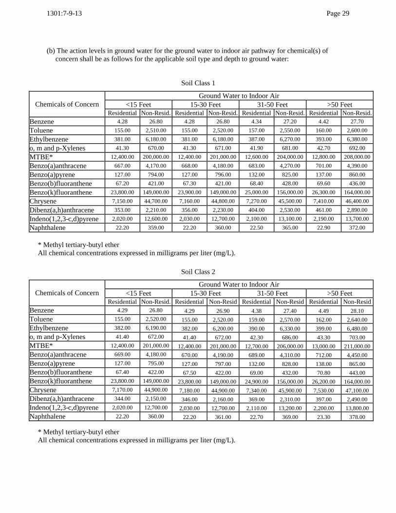
(b) The action levels in ground water for the ground water to indoor air pathway for chemical(s) of
concern shall be as follows for the applicable soil type and depth to ground water:
Soil Class 1
Chemicals of Concern
Ground Water to Indoor Air
<15 Feet 15-30 Feet 31-50 Feet >50 Feet
Residential Non-Resid. Residential Non-Resid. Residential Non-Resid. Residential Non-Resid.
Benzene 4.28 26.80 4.28 26.80 4.34 27.20 4.42 27.70
Toluene 155.00 2,510.00 155.00 2,520.00 157.00 2,550.00 160.00 2,600.00
Ethylbenzene 381.00 6,180.00 381.00 6,180.00 387.00 6,270.00 393.00 6,380.00
o, m and p-Xylenes 41.30 670.00 41.30 671.00 41.90 681.00 42.70 692.00
MTBE* 12,400.00 200,000.00 12,400.00 201,000.00 12,600.00 204,000.00 12,800.00 208,000.00
Benzo(a)anthracene 667.00 4,170.00 668.00 4,180.00 683.00 4,270.00 701.00 4,390.00
Benzo(a)pyrene 127.00 794.00 127.00 796.00 132.00 825.00 137.00 860.00
Benzo(b)fluoranthene 67.20 421.00 67.30 421.00 68.40 428.00 69.60 436.00
Benzo(k)fluoranthene 23,800.00 149,000.00 23,900.00 149,000.00 25,000.00 156,000.00 26,300.00 164,000.00
Chrysene 7,150.00 44,700.00 7,160.00 44,800.00 7,270.00 45,500.00 7,410.00 46,400.00
Dibenz(a,h)anthracene 353.00 2,210.00 356.00 2,230.00 404.00 2,530.00 461.00 2,890.00
Indeno(1,2,3-c,d)pyrene 2,020.00 12,600.00 2,030.00 12,700.00 2,100.00 13,100.00 2,190.00 13,700.00
Naphthalene 22.20 359.00 22.20 360.00 22.50 365.00 22.90 372.00
* Methyl tertiary-butyl ether
All chemical concentrations expressed in milligrams per liter (mg/L).
Soil Class 2
Chemicals of Concern
Ground Water to Indoor Air
<15 Feet 15-30 Feet 31-50 Feet >50 Feet
Residential Non-Resid. Residential Non-Resid Residential Non-Resid Residential Non-Resid
Benzene 4.29 26.80 4.29 26.90 4.38 27.40 4.49 28.10
Toluene 155.00 2,520.00 155.00 2,520.00 159.00 2,570.00 162.00 2,640.00
Ethylbenzene 382.00 6,190.00 382.00 6,200.00 390.00 6,330.00 399.00 6,480.00
o, m and p-Xylenes 41.40 672.00 41.40 672.00 42.30 686.00 43.30 703.00
MTBE* 12,400.00 201,000.00 12,400.00 201,000.00 12,700.00 206,000.00 13,000.00 211,000.00
Benzo(a)anthracene 669.00 4,180.00 670.00 4,190.00 689.00 4,310.00 712.00 4,450.00
Benzo(a)pyrene 127.00 795.00 127.00 797.00 132.00 828.00 138.00 865.00
Benzo(b)fluoranthene 67.40 422.00 67.50 422.00 69.00 432.00 70.80 443.00
Benzo(k)fluoranthene 23,800.00 149,000.00 23,800.00 149,000.00 24,900.00 156,000.00 26,200.00 164,000.00
Chrysene 7,170.00 44,900.00 7,180.00 44,900.00 7,340.00 45,900.00 7,530.00 47,100.00
Dibenz(a,h)anthracene 344.00 2,150.00 346.00 2,160.00 369.00 2,310.00 397.00 2,490.00
Indeno(1,2,3-c,d)pyrene 2,020.00 12,700.00 2,030.00 12,700.00 2,110.00 13,200.00 2,200.00 13,800.00
Naphthalene 22.20 360.00 22.20 361.00 22.70 369.00 23.30 378.00
* Methyl tertiary-butyl ether
All chemical concentrations expressed in milligrams per liter (mg/L).

1301:7-9-13 Page 30
Soil Class 3
Chemicals of Concern
Ground Water to Indoor Air
<15 Feet 15-30 Feet 31-50 Feet >50 Feet
Residential Non-Resid. Residential Non-Resid. Residential Non-Resid. Residential Non-Resid.
Benzene 4.39 27.50 4.42 27.60 4.80 30.10 5.26 32.90
Toluene 159.00 2,580.00 160.00 2,600.00 174.00 2,820.00 190.00 3,090.00
Ethylbenzene 391.00 6,350.00 393.00 6,380.00 427.00 6,930.00 468.00 7,590.00
o, m and p-Xylenes 42.40 688.00 42.70 692.00 46.40 752.00 50.80 824.00
MTBE* 12,700.00 206,000.00 12,800.00 207,000.00 13,900.00 226,000.00 15,300.00 249,000.00
Benzo(a)anthracene 669.00 4,190.00 670.00 4,190.00 690.00 4,320.00 714.00 4,470.00
Benzo(a)pyrene 126.00 789.00 126.00 790.00 129.00 804.00 131.00 822.00
Benzo(b)fluoranthene 68.90 431.00 69.30 433.00 74.90 469.00 81.70 511.00
Benzo(k)fluoranthene 23,500.00 147,000.00 23,600.00 147,000.00 23,900.00 150,000.00 24,400.00 153,000.00
Chrysene 7,330.00 45,800.00 7,360.00 46,100.00 7,960.00 49,800.00 8,660.00 54,200.00
Dibenz(a,h)anthracene 337.00 2,110.00 337.00 2,110.00 342.00 2,140.00 347.00 2,170.00
Indeno(1,2,3-c,d)pyrene 2,010.00 12,600.00 2,010.00 12,600.00 2,050.00 12,800.00 2,090.00 13,100.00
Naphthalene 22.80 370.00 22.90 372.00 25.00 406.00 27.50 446.00
* Methyl tertiary-butyl ether
All chemical concentrations expressed in milligrams per liter (mg/L).
(c) The action levels in ground water for the ground water to outdoor air pathway for chemical(s) of concern shall be as follows for the applicable soil type:
Soil Class 1
Chemicals of Concern Ground Water to Outdoor Air
Residential Non-Residential Excavation Worker
Benzene 818.00 515.00 5,520.00
Toluene 32,500.00 53,100.00 68,800.00
Ethylbenzene 82,700.00 135,000.00 175,000.00
o, m, and p-Xylenes 8,560.00 14,000.00 18,100.00
Methyl tertiary-butyl ether (MTBE) 758,000.00 >1E^+6 >1E^+6
Benzo(a)anthracene 24,800.00 15,600.00 507,000.00
Benzo(a)pyrene 7,680.00 4,840.00 157,000.00
Benzo(b)fluoranthene 2,020.00 1,270.00 41,200.00
Benzo(k)fluoranthene >1E^+6 >1E^+6 >1E^+6
Chrysene 212,000.00 133,000.00 >1E^+6
Dibenz(a,h)anthracene 78,400.00 49,400.00 >1E^+6
Indeno(1,2,3-c,d)pyrene 123,000.00 77,200.00 >1E^+6
Naphthalene 1,200.00 1,970.00 2,550.00
All chemical concentrations expressed in milligrams per liter (mg/L).

1301:7-9-13 Page 31
Soil Class 2
Chemicals of Concern Ground Water to Outdoor Air
Residential Non-Residential Excavation Worker
Benzene 860.00 541.00 5,800.00
Toluene 34,000.00 55,600.00 72,000.00
Ethylbenzene 86,300.00 141,000.00 183,000.00
o, m and p-Xylenes 8,960.00 14,600.00 18,900.00
Methyl tertiary-butyl ether (MTBE) 885,000.00 >1E^+6 >1E^+6
Benzo(a)anthracene 31,600.00 19,900.00 645,000.00
Benzo(a)pyrene 8,200.00 5,170.00 167,000.00
Benzo(b)fluoranthene 2,720.00 1,710.00 55,500.00
Benzo(k)fluoranthene >1E^+6 >1E^+6 >1E^+6
Chrysene 286,000.00 180,000.00 >1E^+6
Dibenz(a,h)anthracene 38,700.00 24,400.00 789,000.00
Indeno(1,2,3-c,d)pyrene 131,000.00 82,400.00 >1E^+6
Naphthalene 1,430.00 2,340.00 3,030.00
All chemical concentrations expressed in milligrams per liter (mg/L).
Soil Class 3
Chemicals of Concern Ground Water to Outdoor Air
Residential Non-Residential Excavation Worker
Benzene 1,350.00 848.00 9,080.00
Toluene 51,500.00 84,100.00 109,000.00
Ethylbenzene 129,000.00 211,000.00 273,000.00
o, m, and p-Xylenes 13,600.00 22,200.00 28,800.00
Methyl tertiary-butyl ether (MTBE) >1E^+6 >1E^+6 >1E^+6
Benzo(a)anthracene 33,000.00 20,800.00 673,000.00
Benzo(a)pyrene 3,870.00 2,440.00 78,900.00
Benzo(b)fluoranthene 9,560.00 6,020.00 195,000.00
Benzo(k)fluoranthene >1E^+6 >1E^+6 >1E^+6
Chrysene 991,000.00 625,000.00 >1E^+6
Dibenz(a,h)anthracene 7,210.00 4,540.00 147,000.00
Indeno(1,2,3-c,d)pyrene 61,500.00 38,700.00 >1E^+6
Naphthalene 4,030.00 6,590.00 8,540.00
All chemical concentrations expressed in milligrams per liter (mg/L).

1301:7-9-13 Page 32
(d) The action levels in soil for the direct contact with soil pathway for chemical(s) of concern shall be as follows for all soil types:
Chemicals Of Concern Direct Contact
Residential Non-Residential Excavation Worker
Benzene 9.8 100 310
Toluene 590 5,900 24,000
Ethylbenzene 1,500 17,000 160,000
o, m and p-Xylenes 660 6,400 7,000
Methyl tertiary-butyl ether (MTBE) 5,300 52,000 57,000
Benzo(a)anthracene 11 63 810
Benzo(a)pyrene 1.1 6.3 81
Benzo(b)fluoranthene 11 63 810
Benzo(k)fluoranthene 110 630 8,100
Chrysene 1,100 6,700 41,000
Dibenz(a,h)anthracene 1.1 6.7 41
Indeno(1,2,3-c,d)pyrene 11 67 410
Naphthalene 54 530 1,900
All chemical concentrations expressed in milligrams per kilogram (mg/kg).
(e) The Soil Action Levels for Total Petroleum Hydrocarbon (TPH) shall be as follows:
Petroleum Fraction Soil Class 1 Soil Class 2 Soil Class 3
Light Distillate Fraction (C6-C12) 1,000 5,000 8,000
Middle Distillate Fraction (C10-20) 2,000 10,000 20,000
Heavy Distillate Fraction (C20-C34) 5,000 20,000 40,000
All chemical concentrations expressed in milligrams per kilogram (mg/kg).

1301:7-9-13 Page 33
(f) The action levels in soil for the soil to indoor air, soil to outdoor air, soil to drinking water leaching and soil to non-drinking water leaching pathway for
chemical(s) of concern shall be as follows for the applicable soil type:
Soil Class 1
Chemicals of Concern Soil to Indoor Air Soil to Outdoor Air
Soil to
Drinking
Water
Leaching
Soil to Non-
Drinking
Water Residential Non-Residential Residential Non-Residential Excavation
Benzene 1.04 6.50 32.70 20.60 221.00 0.149 12.80
Toluene 61.300 994.00 1,930.00 3,150.00 4,090.00 49.100 760.00
Ethylbenzene 199.000 3,230.00 6,280.00 10,300.00 13,300.00 45.500 2,480.00
o, m and p-Xylenes 15.700 254.00 494.00 806.00 1,040.00 469.00 194.00
Methyl tertiary-butyl ether (MTBE) 1,240.00 20,200.00 39,300.00 64,200.00 83,100.00 0.470 14,600.00
Benzo(a)anthracene 476,000.00 >1E^+6 >1E^+6 >1E^+6 >1E^+6 22.20 >1E^+6
Benzo(a)pyrene 245,000.00 >1E^+6 >1E^+6 >1E^+6 >1E^+6 50.60 >1E^+6
Benzo(b)fluoranthene 165,000.00 >1E^+6 >1E^+6 >1E^+6 >1E^+6 55.30 >1E^+6
Benzo(k)fluoranthene >1E^+6 >1E^+6 >1E^+6 >1E^+6 >1E^+6 501.00 >1E^+6
Chrysene >1E^+6 >1E^+6 >1E^+6 >1E^+6 >1E^+6 441,000.00 >1E^+6
Dibenz(a,h)anthracene >1E^+6 >1E^+6 >1E^+6 >1E^+6 >1E^+6 9.40 >1E^+6
Indeno(1,2,3-c,d)pyrene >1E^+6 >1E^+6 >1E^+6 >1E^+6 >1E^+6 244.00 >1E^+6
Naphthalene 54.000 877.000 1,710.00 2,790.00 3,610.00 39.80 632.00
All chemical concentrations expressed in milligrams per kilogram (mg/kg).

1301:7-9-13 Page 34
Soil Class 2
Chemical of Concern Soil to Indoor Air Soil to Outdoor Air
Soil to
Drinking
Water
Leaching
Soil to Non-
Drinking
Water Residential Non-Residential Residential Non-Residential Excavation
Benzene 1.15 7.22 51.00 32.10 344.00 0.252 21.60
Toluene 70.800 1,150.000 3,130.00 5,110.00 6,610.00 105.000 1,630.00
Ethylbenzene 233.000 3,780.000 10,300.00 16,800.00 21,800.00 83.000 4,530.00
o, m and p-Xylenes 18.000 291.000 793.00 1,300.00 1,680.00 825.000 342.00
Methyl tertiary-butyl ether (MTBE) 1,370.000 22,200.000 60,500.00 98,900.00 128,000.00 0.788 24,400.00
Benzo(a)anthracene 596,000.000 >1E^+6 >1E^+6 >1E^+6 >1E^+6 18,600.00 >1E^+6
Benzo(a)pyrene 306,000.000 >1E^+6 >1E^+6 >1E^+6 >1E^+6 >1E^+6 >1E^+6
Benzo(b)fluoranthene 206,000.000 >1E^+6 >1E^+6 >1E^+6 >1E^+6 >1E^+6 >1E^+6
Benzo(k)fluoranthene >1E^+6 >1E^+6 >1E^+6 >1E^+6 >1E^+6 738,000.00 >1E^+6
Chrysene >1E^+6 >1E^+6 >1E^+6 >1E^+6 >1E^+6 >1E^+6 >1E^+6
Dibenz(a,h)anthracene >1E^+6 >1E^+6 >1E^+6 >1E^+6 >1E^+6 >1E^+6 >1E^+6
Indeno(1,2,3-c,d)pyrene >1E^+6 >1E^+6 >1E^+6 >1E^+6 >1E^+6 >1E^+6 >1E^+6
Naphthalene 67.300 1,090.000 2,980.00 4,860.00 6,300.00 84.20 1,340.00
All chemical concentrations expressed in milligrams per kilogram (mg/kg).
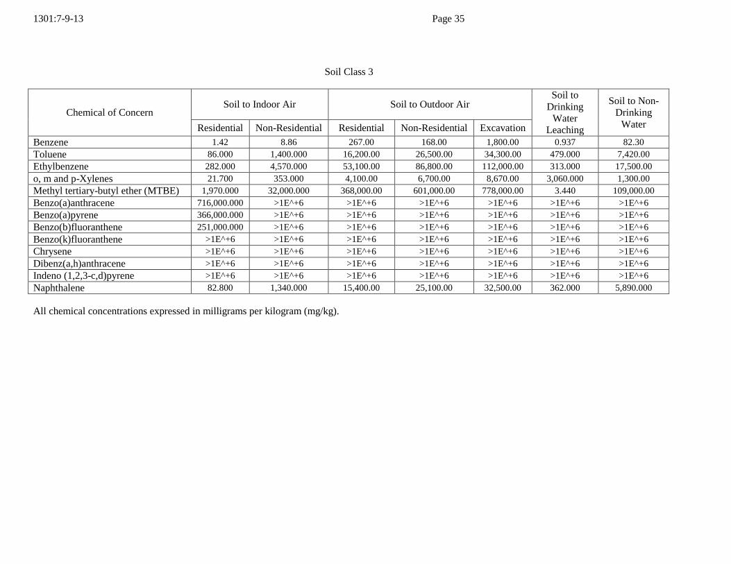
1301:7-9-13 Page 35
Soil Class 3
Chemical of Concern Soil to Indoor Air Soil to Outdoor Air
Soil to
Drinking
Water
Leaching
Soil to Non-
Drinking
Water Residential Non-Residential Residential Non-Residential Excavation
Benzene 1.42 8.86 267.00 168.00 1,800.00 0.937 82.30
Toluene 86.000 1,400.000 16,200.00 26,500.00 34,300.00 479.000 7,420.00
Ethylbenzene 282.000 4,570.000 53,100.00 86,800.00 112,000.00 313.000 17,500.00
o, m and p-Xylenes 21.700 353.000 4,100.00 6,700.00 8,670.00 3,060.000 1,300.00
Methyl tertiary-butyl ether (MTBE) 1,970.000 32,000.000 368,000.00 601,000.00 778,000.00 3.440 109,000.00
Benzo(a)anthracene 716,000.000 >1E^+6 >1E^+6 >1E^+6 >1E^+6 >1E^+6 >1E^+6
Benzo(a)pyrene 366,000.000 >1E^+6 >1E^+6 >1E^+6 >1E^+6 >1E^+6 >1E^+6
Benzo(b)fluoranthene 251,000.000 >1E^+6 >1E^+6 >1E^+6 >1E^+6 >1E^+6 >1E^+6
Benzo(k)fluoranthene >1E^+6 >1E^+6 >1E^+6 >1E^+6 >1E^+6 >1E^+6 >1E^+6
Chrysene >1E^+6 >1E^+6 >1E^+6 >1E^+6 >1E^+6 >1E^+6 >1E^+6
Dibenz(a,h)anthracene >1E^+6 >1E^+6 >1E^+6 >1E^+6 >1E^+6 >1E^+6 >1E^+6
Indeno (1,2,3-c,d)pyrene >1E^+6 >1E^+6 >1E^+6 >1E^+6 >1E^+6 >1E^+6 >1E^+6
Naphthalene 82.800 1,340.000 15,400.00 25,100.00 32,500.00 362.000 5,890.000
All chemical concentrations expressed in milligrams per kilogram (mg/kg).

1301:7-9-13 Page 36
(4) Multiple chemical adjustments.
Where ten or more non-carcinogenic or carcinogenic chemicals of concern are present when
analyzing for Analytical Groups 4 and/or 5, the standard for each chemical of concern shall be
adjusted to meet the following goals:
(a) For chemicals of concern having carcinogenic effects, the cumulative carcinogenic risk for all
chemical(s) of concern shall not exceed a total excess upper bound cancer risk of 1x 10-05
(i.e., one excess cancer in a population of 100,000);
(b) For chemicals of concern having non-carcinogenic effects, the cumulative risk for all chemical(s) of concern shall not exceed a hazard index of 1.
(c) A cumulative adjustment shall be made for each of the following pathways:
(i) Ground water ingestion;
(ii) Direct contact with soil;
(iii) Soil to indoor air; and
(iv) Ground water to indoor air.
(K) Interim Response Action.
(1) If an Interim Response Actions is to be conducted it must be implemented within ninety days of
approval of a Tier 1 Delineation conducted pursuant to paragraph (I) of this rule, a Tier 2
Evaluation conducted pursuant to paragraph (L) of this rule or a Tier 3 Evaluation conducted
pursuant to paragraph (M) of this rule. Once an Interim Response Action has been completed,
previously identified potentially complete exposure pathways shall be re-evaluated.
(2) An Interim Response Action Notification shall be submitted on a form prescribed by the fire
marshal ten days prior to beginning the Interim Response Action. The notification shall include the following:
(a) A description of the Interim Response Action;
(b) The anticipated volume of soil to be removed, if applicable;
(c) The estimated volume of free product and/or ground water to be recovered, if applicable;
(d) The anticipated length of time of the interim response action;
(e) A site map indicating the limits of excavation if soil is to be removed; and

1301:7-9-13 Page 37
(f) A proposed sampling and analysis plan.
(3) Prior approval of an interim response action shall be obtained from the fire marshal if:
(a) The combined total volume of soil to be excavated for all tier evaluations will be greater than eight hundred cubic yards;
(b) The anticipated time to initiate and complete the interim response action is greater than three
months; or
(c) More than one interim response action is to be conducted.
(4) A report summarizing the Interim Response Action(s) shall be submitted to the fire marshal within
sixty days of completing the activities and shall contain, at a minimum, the following information
as appropriate:
(a) A completed Petroleum Contaminated Soil form as provided by the fire marshal;
(b) Copies of laboratory data sheets and chain-of-custody form(s);
(c) A site map showing the limits of the excavation zone(s) and sample locations;
(d) A discussion of sample collection, field screening and preservation techniques;
(e) A discussion of the treatment technique used to address chemical(s) of concern in soil and/or
ground water;
(f) Actual volume of soil and/or ground water remediated; and
(g) A discussion of soil and ground water disposal techniques.
(L) Tier 2 Evaluation.
The purpose of a Tier 2 Evaluation is to define the distribution of chemical(s) of concern to the
applicable action levels, determine the current and potential future land use for the UST site and
surrounding properties, develop a site conceptual exposure model and develop site-specific target
levels using spreadsheets and models approved by the fire marshal. A Tier 2 Evaluation shall be conducted in accordance with all of the following:
(1) Determination of the distribution of chemical(s) of concern.
(a) The distribution of chemical(s) of concern shall be delineated to the applicable Tier 1
action level(s) determined for the UST site.
1301:7-9-13 Page 38
(b) Soil borings and ground water monitoring wells shall be installed in accordance with paragraph (H)(1)(d) of this rule.
(c) If the highest concentration of a particular chemical(s) of concern is determined to be
below detection limits and below action levels as specified by this rule during the Tier 1
Source Investigation conducted pursuant to paragraph (H) of this rule, then that
chemical(s) of concern may be excluded from future tier evaluations.
(d) If the determination of the likely distribution of chemical(s) of concern requires off-site
access, owners and operators shall use their best efforts to obtain permission to enter such
off-site areas to complete the investigations required by this rule. If access cannot be
obtained, owners or operators shall submit notice to the fire marshal within forty-five days
after determining off-site access cannot be obtained. The notice shall describe the efforts
taken by the owners or operators to obtain off-site access and the reasons why access could
not be obtained. Owners and operators shall take additional action to obtain off-site access if requested by the fire marshal.
(2) Land use determination.
(a) Land use for the UST site shall be residential unless:
(i) The current land use at the UST site is not residential and seventy-five percent of the area
within three hundred feet of the property boundaries of the UST site is non-residential land use; or
(ii) A land use restriction as approved by the fire marshal for the UST site in accordance with
paragraph (L)(4)(a)(ii)(c) of this rule has been documented and recorded in the county
where the UST site is located or the owners and operators enter into an environmental
covenant with the fire marshal in accordance with sections 5301.80 through 5301.92 of
the Revised Code, or implement a deed restriction as approved by the fire marshal.
(b) Land use for the UST site and adjacent properties shall be determined as residential or non-residential using reasonably available information based on the following:
(i) The historical land use of the UST site and adjacent properties;
(ii) The current land use of the UST site and adjacent properties;
(iii) The historical zoning or planning designation for the UST site and adjacent properties;
and
(iv) The current zoning or planning designation for the UST site and adjacent properties.
(3) Action level determination.
Action levels for the UST site shall be determined in accordance with the following:

1301:7-9-13 Page 39
(a) Non-residential land use.
(i) If the UST site meets the non-residential land use determination pursuant to paragraph
(L)(2)(a) of this rule, then the owners and operators shall compare the concentrations of
chemical(s) of concern to the appropriate non-residential action levels and ground water use action levels in paragraph (J)(3) of this rule.
(a) If the concentrations of all chemical(s) of concern are at or below the action levels for
all applicable pathways, then no further action is required. The owners and operators
shall prepare a Tier 2 Evaluation report in accordance with paragraph (L)(7) of this rule.
(b) If the concentration of a specific chemical of concern is at or below the action
level(s), then no further evaluation is necessary for that chemical of concern and for the corresponding complete exposure pathway.
(c) If one or more of the concentrations of chemical(s) of concern are above non-
residential land use and/or ground water use action levels as determined in
accordance with paragraph (I)(2) of this rule for any applicable pathway, owners and
operators shall develop a site conceptual exposure model pursuant to paragraph
(L)(4) of this rule.
(b) Residential land use.
If the UST site does not meet the non-residential land use determination pursuant to
paragraph (L)(2) of this rule, owners and operators shall develop a site conceptual exposure
model pursuant to paragraph (L)(4) of this rule.
(c) If chemical(s) of concern have migrated off the UST site, action levels shall be developed for
each impacted property pursuant to paragraph (J) of this rule according to the corresponding land use.
(4) Site conceptual exposure model.
A site conceptual exposure model shall be developed to clearly describe the conditions under
which an exposure to chemical(s) of concern may occur by identifying exposure pathways and points of exposure in accordance with the following:
(a) Pathway evaluation.
(i) Exposure pathway identification.
Identify all exposure pathways that exceed Tier 1 action levels determined pursuant to
paragraph (H)(2) and (L)(3) of this rule. Pathway identification shall include identifying
all receptors, media and transport mechanisms and routes of exposure in accordance with

1301:7-9-13 Page 40
the following:
(a) Receptor identification
Identify current and potential future receptors that may be exposed to the release. At a minimum, the following potential receptors shall be evaluated:
(i) Adults and children for residential scenarios;
(ii) Adults for non-residential scenarios;
(iii) Adults for excavation worker scenarios; and
(vi) Aquatic life and recreational receptors in a surface water body located within 300
feet of the UST site.
(b) Media identification.
The environmental media that are likely to contain concentrations of chemicals of
concern shall be identified for evaluation. The following environmental media shall
be evaluated:
(i) Soil;
(ii) Ground water;
(iii) Surface water;
(iv) Indoor air; and
(v) Outdoor air.
(c) Transport mechanisms identification.
All fate and transport mechanisms for chemical(s) of concern in the environmental
media shall be identified. The following transport mechanisms shall be evaluated for all applicable pathways:
(i) Atmospheric dispersion;
(ii) Volatilization;
(iii) Enclosed space vapor accumulation; and

1301:7-9-13 Page 41
(iv) Soil leaching and ground water transport.
(d) Routes of exposure identification.
The following routes of exposure shall be evaluated:
(i) Ingestion;
(ii) Inhalation; and
(iii) Direct contact.
(ii) Pathway completeness evaluation.
Evaluate exposure pathways to determine if the exposure pathways identified in the site
conceptual exposure model developed in accordance with paragraph (L)(4)(a)(i) of this
rule are complete.
(a) An exposure pathway is incomplete when any one of the following criteria exists:
(i) There is no point(s) of exposure identified pursuant to paragraph (L)(4)(b) of this rule, for a chemical of concern in an identified environmental media;
(ii) Site-specific data demonstrates that there is no transport mechanism in the
identified environmental media to move the chemical(s) of concern from the
source area(s) to the point(s) of exposure;
(iii) Site-specific data demonstrates that there are no route(s) of exposure for the identified receptor
(iv) Points of exposure are eliminated by ground water use restrictions enforceable by
a local government and/or regulatory agency, a deed restriction, or an environmental covenant with the fire marshal;
(v) Points of exposure are eliminated by land use restrictions enforceable by a local
government and/or regulatory agency, a deed restriction, or an environmental
covenant with the fire marshal.
(b) If the pathway cannot be determined to be incomplete according to the criteria listed
in paragraph (L)(4)(a)(ii)(a) of this rule, the exposure pathway shall be considered
complete.
(c) Land use restrictions.
Where points of exposure are eliminated based on a land use restriction, owners and

1301:7-9-13 Page 42
operators shall enter into an environmental covenant with the fire marshal in
accordance with sections 5301.80 through 5301.92 of the Revised Code or implement
a deed restriction as approved by the fire marshal that is recorded in the county where
the UST site is located for the purpose of restricting the land use to activities that are
consistent with the land use determination. A copy of the mechanism used shall be provided with the Tier 2 Evaluation report.
(d) Ground water use restrictions.
Where points of exposure are eliminated based on a ground water use restriction,
owners and operators shall enter into an environmental covenant with the fire
marshal in accordance with sections 5301.80 through 5301.92 of the Revised Code or
implement a deed restriction as approved by the fire marshal that is recorded in the
county where the UST site is located for the purpose of restricting the drinking water
use to activities that are consistent with the ground water use determination. A copy of the mechanism used shall be provided with the Tier 2 Evaluation report.
(iii) Pathway evaluation conclusions.
(a) If an exposure pathway is determined to be complete in accordance with paragraph
(L)(4)(a)(ii)(b) of this rule, then owners and operators shall evaluate points of exposure pursuant to paragraph (L)(4)(b) of this rule.
(b) If an exposure pathway is determined to be incomplete in accordance with paragraph
(L)(4)(a)(ii)(a) of this rule, then no further evaluation will be required for that
exposure pathway. The determination that an exposure pathway is incomplete shall
be documented and based on information and data collected during the Tier 2
Evaluation.
(b) Points of exposure.
(i) Identify point(s) of exposure based on the current and reasonably anticipated future use at
the UST site and in the surrounding area. At a minimum, all of the following potential
point(s) of exposure shall be evaluated:
(a) Where ground water has been determined to be a drinking water source in accordance
with paragraph (I)(2)(c) or (I)(2)(e) of this rule, the point of exposure shall be one of the following, whichever is closest to the source area(s):
(i) Any potable well located on the UST site;
(ii) The property line when the UST site is located in a Drinking Water Source
Protection Area;
(iii) The Drinking Water Source Protection Area boundary if a Drinking Water Source Protection Area is within 300 feet of the UST site;

1301:7-9-13 Page 43
(iv) The property line, unless one of the following can be demonstrated:
(A) No potable wells are located within 300 feet of the UST site based on a
physical survey and an ordinance requires a mandatory tie-in to a municipal
water system for all properties in the surrounding area;
(B) No potable wells are located within 300 feet of the UST site based on a
physical survey and an ordinance prohibits the installation of potable water
wells at all properties within the surrounding area;
(C) No potable wells are located within 300 feet of the UST site based on a
physical survey and 100 percent of the properties within 300 feet of the UST
site are connected to a municipal water source or a municipal source is
readily available; or
(D) A roadway or railroad separates the source from the down gradient property
where a well could be installed, in which case the point of exposure shall be the property line of that property.
(v) If a point of exposure has not been identified in paragraph (L)(4)(b)(i)(a)(i)
through (L)(4)(b)(i)(a)(iv) of this rule, the point of exposure shall be 300 feet
from the source area(s) or an alternate point of exposure approved by the fire marshal; or
(vi) Not withstanding paragraph (L)(4(b)(i)(a)(i) through (L)(4(b)(i)(a)(v) , the fire
marshal may require that point(s) of exposure be evaluated other than or in addition to those specified in paragraph (L)(4)(b) of this rule.
(b) Surface water where a surface water body exists within 300 feet of the UST site;
(c) Residential and/or other buildings located or anticipated to be located above soil or ground water containing concentrations of chemical(s) of concern;
(d) Subsurface structures, such as utility manways and underground tunnels; and
(e) Surface and subsurface soil areas where:
(i) The current or reasonably anticipated future use is determined to be residential
land use then a point of exposure for direct contact with surface soil shall be zero to ten feet below ground surface.
(ii) The current and reasonably anticipated future use is determined to be non-
residential then a point of exposure for direct contact with surface soil shall be zero to two feet below ground surface.
(c) If the distribution of chemical(s) of concern cannot be defined on properties that are impacted

1301:7-9-13 Page 44
or potentially impacted by the release, concentrations of chemical(s) of concern at the
affected property boundary line(s) shall meet action levels appropriate to each property’s land
use determination.
(5) Site-specific target level development.
(a) Fate and transport of chemical(s) of concern above action levels that have complete exposure pathways shall be evaluated by conducting one or a combination of the following:
(i) Develop site-specific target levels by replacing default values specified by the fire marshal
for the geological, hydrogeological, and physical parameters in the algorithms used to develop action levels with site-specific values;
(ii) Utilize analytical fate and transport modeling, approved by the fire marshal, to predict concentrations of chemical(s) of concern at each point of exposure; or
(iii) Back calculate site-specific target levels by utilizing analytical fate and transport models,
approved by the fire marshal, from the point(s) of exposure to the source area for any
complete pathway(s). The calculated site-specific target levels must be protective of
human health and the environment at each point of exposure determined pursuant to paragraph (L)(4)(b) of this rule.
(b) The default values shall not be replaced by alternative literature values. Any non-default input data shall be representative of the UST site conditions.
(c) Proper documentation of the modeling work shall be prepared and submitted to the fire
marshal within the Tier 2 Evaluation report. The documentation shall include input values,
assumptions and the results of the modeling. Model results must be reproducible by the fire
marshal.
(d) After determining site-specific target levels, the maximum concentrations of chemical(s) of
concern for each complete exposure pathway shall be compared to the calculated site-specific target levels.
(e) Where site-specific target levels are developed based on land use other than residential land
use and non-residential land use is not established in accordance with paragraph (L)(2)(a)(i)
of this rule, owners and operators shall enter into an environmental covenant with the fire
marshal in accordance with sections 5301.80 through 5301.92 of the Revised Code or
implement a deed restriction as approved by the fire marshal to restrict the land use to
activities that are consistent with the land use determination. A copy of the mechanism used
shall be provided with the Tier 2 Evaluation report.
(f) Where site-specific target levels are developed based on ground water use other than drinking
water use and non-drinking water use is not established in accordance with paragraph
(I)(2)(d) of this rule, owners and operators shall enter into an environmental covenant with
the fire marshal in accordance with sections 5301.80 through 5301.92 of the Revised Code or
implement a deed restriction as approved by the fire marshal to restrict the drinking water use

1301:7-9-13 Page 45
to activities that are consistent with the ground water use determination. A copy of the mechanism used shall be provided with the Tier 2 Evaluation report.
(6) Tier 2 decisions.
Upon submission of the Tier 2 Evaluation report, the fire marshal will evaluate the submitted
information for completeness. The maximum concentrations of chemical(s) of concern shall be compared to the action level or Tier 2 site-specific target levels, as applicable.
(a) If the concentrations of all chemical(s) of concern are at or below Tier 2 site-specific target
levels for all pathways and no monitoring is required pursuant to paragraph (O) of this rule,
then no further action is required. If required by paragraph (O) of this rule, a monitoring plan
shall be developed for ground water and submitted with the Tier 2 Evaluation report,
prepared in accordance with paragraph (L)(7) of this rule, to demonstrate that concentrations of all chemical(s) of concern will remain at or below Tier 2 site-specific target levels.
(b) If the concentration of a specific chemical of concern is at or below the Tier 2 site-specific
target levels, then no further evaluation is necessary for that chemical of concern and for the corresponding complete exposure pathway.
(c) If the concentrations of chemical(s) of concern are above the Tier 2 site-specific target levels
for one or more exposure pathways, then the owners and operators shall complete one or a
combination of the following to address the chemical(s) of concern and the corresponding complete exposure pathways:
(i) An Interim Response Action, under paragraph (K) of this rule, may be implemented to
eliminate a complete exposure pathway or to reduce concentrations of chemical(s) of
concern in the source area(s) to a level at or below the Tier 2 site-specific target levels in accordance with paragraph (L) of this rule.
(ii) A Remedial Action Plan, pursuant to paragraph (N) of this rule, may be developed using
the Tier 2 site-specific target levels for remedial action.
(iii) A Tier 3 Evaluation plan in accordance with paragraph (M) of this rule may be developed and submitted with the Tier 2 Evaluation report.
(iv) A plan for approval by the fire marshal to calibrate or disprove the fate and transport
model using additional site-specific data. This plan shall be submitted with the Tier 2 Evaluation report.
(7) Tier 2 Evaluation report.
(a) Owners and operators shall prepare and submit the Tier 2 Evaluation report to the fire marshal, within eighteen months from the approval of the Tier 1 Investigation report:

1301:7-9-13 Page 46
(b) The Tier 2 Evaluation report shall include all of the following information:
(i) A summary of the maximum concentrations for all chemical(s) of concern in soil and
ground water, the potential drinking water use determination, depth-to-ground water and
the soil class for each complete pathway determined during the Tier 1 Source Investigation and the Tier 1 Delineation activities;
(ii) Tier 2 Delineation documentation.
A summary of the Tier 2 Delineation data collection activities that includes, at a
minimum, the following information:
(a) A summary of the rationale for sampling and testing locations;
(b) A description of the field methodologies employed, including instrument calibration techniques and the make and model of equipment used;
(c) A site map that accurately depicts the locations of current and historical underground
storage tank system(s), property boundaries, street locations, above ground structures,
underground utilities, on-site potable well(s) and soil.
(d) Drilling logs and well construction diagrams that include:
(i) Type of sampler used (e.g., Shelby tube, California sampler, split-spoon);
(ii) The presence of organic vapors as determined by field screening techniques;
(iii) A description of the presence of free product;
(iv)Depth at which saturated conditions were first encountered during drilling and the depth of the static water level;
(v) A complete description of the soil sample for each sampling interval including;
(A) The color and moisture content;
(B) The USCS classification;
(C) The gradation consistency;
(D) A description of horizontal and/or vertical fracturing of bedrock encountered while drilling;
(E) The type and a description of bedrock with differentiation between weathered
and competent bedrock;

1301:7-9-13 Page 47
(F) A description of any voids or significant pressure changes observed in bedrock drilling;
(G) A graphic illustration of each sample interval;
(H) A description of which soil sample interval(s) were sent to the laboratory for
analysis; and
(I) The sample recovery for each interval in units of feet.
(e) Monitoring well sampling and development logs, documenting the number and
quantity of well purging volumes, date, time and duration of collection and
development.
(f) Depth-to-fluid, depth-to-water, free product thickness measurements, and top-of-
casing and ground water elevations in tabular form for each well. When available,
include historical data in the table and reference the source(s) of all information
presented.
(g) A ground water elevation contour map using all relevant monitoring wells to establish
ground water contour and flow direction and clearly indicating the dates that ground
water measurements were collected. Justification for the exclusion of specific
monitoring wells in the determination of flow direction, if applicable, shall be provided.
(h) The calculation of the hydraulic gradient;
(i) Analytical laboratory results including:
(i) Laboratory analyses in tabular form, by environmental medium, including
applicable action levels. Present current results along with historical results,
when available. Indicate sample collection date(s) and reference source(s) of all
information presented. All tables shall include the corresponding method detection limit for each analysis that was below detection limits; and
(ii) All analytical results, QA/QC procedures and data quality objectives including,
without limitation, all laboratory certificates of analysis (data sheets), completed
chain-of-custody forms indicating soil boring and/or monitoring well numbers and laboratory sample numbers.
(j) Chemical(s) of concern concentration maps for soil in units of milligrams per
kilogram (mg/kg) and ground water in units of milligrams per liter (mg/l). Maps shall
include the location of sampling points, the depth of each soil sample interval; and the location of each source area(s).

1301:7-9-13 Page 48
(k) Documentation regarding off-site access pursuant to paragraph (L)(1)(d) of this rule, as appropriate.
(iii) Land use determination documentation including:
(a) A map depicting the land use of the UST site and all surrounding properties within
300-feet of the UST site; and
(b) Supporting documentation and a summary of the land use determination conducted pursuant to paragraph (L)(2) of this rule.
(iv) Land and ground water use restrictions including:
(a) A discussion of land and ground water use restrictions documenting the source(s) of
all information that details the restriction(s); and
(b) Provide a copy of all ordinances, recorded land and ground water use restriction documents and recorded environmental covenants.
(v) Site conceptual exposure model documentation.
Provide a summary of the pathway evaluation as developed in paragraph (L)(4)(a) and
the point(s) of exposure in paragraph (L)(4)(b) of this rule. All sources of information in
the report shall be documented.
(vi) Documentation of site-specific target level development.
Provide a summary of the activities conducted, the results of the Tier 2 Evaluation and a
description of models or other methods used to determine site-specific target levels. The
summary shall include the following:
(a) A description of any models used to evaluate data pursuant to paragraph (L)(5)(a)
and (L)(5)(b) of this rule that provides all assumptions, input parameters and output values;
(b) Present maximum concentration of chemical(s) of concern, action levels and site-
specific target levels in tabular form by environmental media and exposure pathway;
(c) Present results of geotechnical testing for soil properties in tabular form referencing
the ASTM method used to perform each test. At a minimum, the following information shall be included:
(i) Drilling logs;
(ii) Equipment and standard procedures used;

1301:7-9-13 Page 49
(iii) Analytical results, QA/QC procedures and data quality objectives including,
without limitation, all laboratory certificates of analysis (data sheets), completed
chain-of-custody form(s) indicating soil boring/monitoring well numbers and laboratory sample numbers; and
(iv) A site map showing the location(s) of geotechnical soil borings.
(d) A summary and documentation of any field investigations conducted to collect site-
specific data.
(vii) A summary of the Interim Response Actions conducted pursuant to paragraph (K) of this rule, including the volume of soil removed and/or ground water treated.
(viii) A summary of future actions and alternatives, including:
(a) A discussion of remedial actions, if appropriate;
(b) A discussion of further tier analysis, if appropriate;
(c) A summary of monitoring events, as appropriate; and
(d) A discussion of interim response actions including the volume of soil removed and/or ground water treated.
(M) Tier 3 Evaluation.
(1) Tier 3 Evaluation plan.
(a) If site-specific target levels are to be developed under a Tier 3 Evaluation, then a Tier 3
Evaluation plan shall be prepared and submitted to the fire marshal for approval with the Tier
2 Evaluation report in accordance with paragraph (L) of this rule. Unless otherwise provided in this rule, this plan shall include all the following:
(i) A description of the objective of the Tier 3 Evaluation and the activities to be conducted;
(ii) A discussion of the effectiveness, cost and the rationale for selecting the Tier 3
Evaluation compared to other remedial action alternatives; and
(iii) An implementation schedule and the projected completion date of the proposed Tier 3 Evaluation.
(b) Upon approval of the Tier 3 Evaluation plan by the fire marshal, owners and operators shall
conduct the activities in accordance with the approved Tier 3 Evaluation plan.

1301:7-9-13 Page 50
(2) Public participation.
(a) For each confirmed release for which a Tier 3 Evaluation plan is submitted to the fire marshal,
the owners and operators shall provide notice to the public in a format approved by the fire
marshal by means designed to reach those members of the public directly affected by the
release and the planned Tier 3 Evaluation. This notice may include, but is not limited to,
public notice in local newspapers, block advertisements, public service announcements,
publication in a state register, letters to individual households, or personal contacts by field staff.
(b) The fire marshal shall ensure that the UST site release information and decisions concerning
the Tier 3 Evaluation plan are made available to the public for inspection upon request.
(c) Before approving a Tier 3 Evaluation plan, the fire marshal may hold a public meeting to
consider comments on the proposed Tier 3 Evaluation plan if there is sufficient public
interest, or for any other reason.
(3) Tier 3 decisions.
(a) If the concentration of a particular chemical(s) of concern is at or below the Tier 3 site-
specific target levels, then no further action is necessary for that chemical of concern and for
the corresponding complete exposure pathway. If required by paragraph (O) of this rule, a
monitoring plan shall be developed for ground water and submitted with the Tier 3
Evaluation report prepared in accordance with paragraph (M)(4) of this rule to demonstrate
that concentrations of chemical(s) of concern will remain at or below Tier 3 site-specific target levels.
(b) If the concentrations of chemical(s) of concern are above the Tier 3 site-specific target levels, then the owners and operators shall conduct one or a combination of the following:
(i) An Interim Response Action may be implemented, in accordance with paragraph (K) of
this rule, to eliminate a complete exposure pathway or to reduce concentrations of
chemical(s) of concern at the source area(s) to at or below the site-specific target levels;
or
(ii) The Tier 3 site-specific target level values may be used as target levels for remedial action and a Remedial Action Plan developed pursuant paragraph (N) of this rule.
(4) Tier 3 Evaluation report.
Within ninety days from the projected completion date stated in the approved Tier 3 Evaluation
plan a report summarizing the activities conducted in accordance with the Tier 3 Evaluation plan
developed in paragraph (M)(1) of this rule and the results of the Tier 3 decisions described in paragraph (M)(3) of this rule shall be submitted to the fire marshal for approval.
(N) Remedial Action.

1301:7-9-13 Page 51
(1) Remedial Action Plan
A Remedial Action Plan shall be prepared and submitted to the fire marshal within ninety days of
approval of the Tier 1 Investigation report pursuant to paragraph (I)(4) of this rule, approval of
the Tier 2 Evaluation pursuant paragraph (L)(7)(a) of this rule or approval of the Tier 3
Evaluation report pursuant to paragraph (M)(4) of this rule. The Remedial Action Plan shall
include, at a minimum, all of the following information:
(a) A description of the remedial action program to be implemented;
(b) Proposed targets levels, identified by chemical(s) of concern and environmental media;
(c) A conceptual design of the remedial action system, detailed engineering drawings are not necessary;
(d) A brief description of remedial action alternatives considered, including a discussion of the
reliability, effectiveness, cost, and time needed for completion, and the rationale for the
selected program;
(e) A Monitoring Plan, prepared in accordance with paragraph (O) of this rule, describing
monitoring to be used to determine whether site-specific target levels are being achieved and
to demonstrate that concentrations of chemical(s) of concern will remain at or below site-specific target levels, including locations of any monitoring wells designated for sampling;
(f) A description of reporting frequency and proposed content of reports;
(g) A description of all permits or other governmental approvals required for implementation of the plan;
(h) A description of activities and studies, if any, required to be performed prior to
implementation of the proposed remedial action; and
(i) An implementation schedule, projected completion date and the submittal date for the completion report of the proposed remedial action.
(2) Public participation.
(a) For each release for which a Remedial Action Plan is submitted to the fire marshal, the
owners and operators shall provide notice to the public in a format approved by the fire
marshal by means designed to reach those members of the public directly affected by the
release and the planned remedial action. This notice may include, but is not limited to, public
notice in local newspapers, block advertisements, public service announcements, publication in a state register, letters to individual households, or personal contacts by field staff.
(b) The fire marshal shall ensure that the UST site release information and decisions concerning

1301:7-9-13 Page 52
the Remedial Action Plans are made available to the public for inspection upon request.
(c) Before approving a Remedial Action Plan, the fire marshal may hold a public meeting to
consider comments on the proposed Remedial Action Plan if there is sufficient public interest
or for any other reason.
(d) The owners and operators shall give public notice that complies with paragraph (N)(2)(a) of
this rule if implementation of an approved Remedial Action Plan does not achieve the
established cleanup levels in the plan and termination of that plan is under consideration by the fire marshal.
(3) Implementation of Remedial Action Plans.
(a) Upon approval of the Remedial Action Plan, owners and operators shall implement the plan.
Owners and operators shall monitor, evaluate, and report to the fire marshal the results of
implementation efforts.
(b) If the treatment technology approved by the fire marshal in the plan has been installed and
operated for the time frame specified in the approved Remedial Action Plan and the
technology is unable to reduce the concentration of chemical(s) of concern to a level at or below action or site-specific target levels, then the owners and operators shall:
(i) Re-evaluate the remedial action alternatives and submit a revised Remedial Action Plan;
(ii) Re-evaluate the assumptions and parameters used to develop the target levels, as appropriate.
(4) Completion report.
Following completion of remedial action in accordance with this rule, owners and operators shall
prepare and submit a completion report no later than the submittal date provided in the approved
plan. The completion report must demonstrate the remedial action objectives have been met. The
report shall contain documentation supporting termination of the remedial action program. Upon
approval of the report, the fire marshal shall issue to the owners and operators written notice that no further action is required at the UST site.
(O) Monitoring Plan
(1) Purpose.
(a) A monitoring plan shall be developed as appropriate to:
(i) Demonstrate that no further action is appropriate in accordance with paragraphs (L)(6)
and (M)(3) of this rule;
(ii) Demonstrate that a remedial action completed in accordance with paragraph (N) of this

1301:7-9-13 Page 53
rule has achieved target levels; and
(iii) Verify fate and transport model assumptions and predictions related to the development
of site-specific target levels pursuant to paragraph (L)(5) of this rule. Historical data may
be used to verify model assumptions and predictions or to reduce the time period of the monitoring plan.
(b) The monitoring plan shall include, at a minimum, all of the following information:
(i) A description of the purpose and objective of the monitoring activity;
(ii) A description of monitoring activities to be conducted, including those conducted to
implement engineering controls;
(iii) The location of the point(s) of demonstration and point(s) of exposure;
(iv) A summary of sampling procedures;
(v) A description of the anticipated length and frequency of the monitoring activity;
(vi) An identification and description of the criteria to be used for termination of the Remedial Action Plan or monitoring activity, as appropriate; and
(vii) Criteria to be used for verifying ground water fate and transport model assumptions and
predictions. The model assumptions shall be validated with empirical data collected from
point(s) of demonstration.
(c) If the objectives of the monitoring plan are not met, then the owners and operators shall conduct one or more of the following:
(i) Continue monitoring activities with fire marshal approval;
(ii) Conduct an Interim Response Action in accordance with paragraph (K) of this rule;
(iii) Develop a Remedial Action Plan in accordance with paragraph (N) of this rule; or
(iv) Re-evaluate the assumptions and parameters used to develop site-specific target levels.
(2) Point(s) of demonstration.
The monitoring plan shall include a point(s) of demonstration between the source area and the
point of exposure and be submitted with the Tier 2 Evaluation report, Remedial Action Plan or
Tier 3 Evaluation report.

1301:7-9-13 Page 54
The process for the selection of the point(s) of demonstration shall consider the location of the
point(s) of exposure including the receptor and exposure route, the transport mechanism (e.g.,
ground water migration, vapor migration) and the estimated travel time from the source to the
point(s) of exposure. The point(s) of demonstration shall be located to monitor the progress of the
remedial action (including natural attenuation) and to verify the predictions related to the
potential fate and transport of the chemical(s) of concern. The point(s) of demonstration shall be
located sufficiently up gradient of the point(s) of exposure to indicate whether continued
migration of the chemical(s) of concern may impact the point(s) of exposure above the applicable action levels.
(3) Completion report.
Following completion of monitoring in accordance with paragraph (O)(1) and (O)(2) of this rule,
owners and operators shall prepare a completion report that demonstrates the monitoring
objectives have been met. The report shall contain documentation supporting termination of the
monitoring plan. Upon approval of the report, the fire marshal shall issue to the owners and
operators written notice that no further action is required at the UST site.
(P) Petroleum contaminated soil.
The storage, treatment and disposal of petroleum contaminated soil generated from corrective actions
undertaken pursuant to this rule shall be in accordance with rule 1301:7-9-16 of the Administrative
Code.
(Q) Requests for extensions.
If owners and operators desire an extension of time in which to comply with any portion of this rule, the owner and operator shall:
(1) Prepare a written request, signed by the owners and operators, setting forth the following:
(a) The date the information was to be submitted;
(b) The reasons for requesting the extension;
(c) The length of time that the extension is requested for;
(d) The name and complete address of the UST site that is the subject of the extension request;
(e) The name of the fire marshal employee that is assigned to monitor the corrective actions activities at the UST site; and
(f) The release number, assigned by the fire marshal, for the UST site that is the subject of the
extension request.

1301:7-9-13 Page 55
(2) Submit a written request in accordance with paragraph (Q)(1) of this rule to the fire marshal prior
to the expiration of the time period that is the subject of the extension request. Submission of the
written request required by paragraph (Q)(1) of this rule is accomplished only upon the actual
receipt of the request by the fire marshal. The fire marshal may grant, modify, or deny any
extension request at his sole discretion.
(R) Alternate Technology.
(1) Technologies other than those specified in this rule may be used if the owner and operator:
(a) Demonstrates to the fire marshal that the alternative technology is at least as effective as those required by this rule; and
(b) Obtains written approval from the fire marshal to use the alternate technology before the
actual implementation of such technology. If the alternate technology is approved by the fire
marshal, the owner and operator using such alternative technologies shall comply with any conditions imposed by the fire marshal on it use.
(2) The fire marshal may approve the alternate technology for use at a specific UST site or for use at
all UST sites. If the fire marshal approves an alternate technology for use at all UST sites, the
owners and operators must comply with any conditions imposed by the fire marshal on the use of the alternate technology.
HISTORY: Eff 5-9-88; 9-1-92; 3-31-99; Replaces: 1301:7-9-13, eff. 3-1-05
Rule promulgated under: RC 119.03
Rule authorized by: RC 3737.88, 3737.882
Rule amplifies: RC 3737.88, 3737.882
R.C. 119.032 review dates: 03/01/2010