Embed Size (px)
Citation preview

LANDSCAPE ARCHITECTURE MAGAZINE NOV 2016 / 103102 / LANDSCAPE ARCHITECTURE MAGAZINE NOV 2016
PW
P LA
ND
SCA
PE
AR
CHIT
ECTU
RE
MY FIRST VISIT TO THE SITE began early one Saturday during a morning full of intermittent rain,
but this did not faze the many people who jogged, meandered, and even sang their way through the site (thank you, random maria-chi band). I sat perched on one of the sand-stone blocks along the foreshore and watched for hours, fascinated. There were painters and picnickers, clusters of mothers pushing strollers; there was a yoga group perched at the top of the headland in precarious posi-tions, as well as occasional elderly visitors pulling themselves along with a walker or cane. Children accompanying their parents walked anywhere but on the path—most preferred to balance their steps along the meandering 1836 Wall (marking the original coastline of that year), while others darted off and scrambled over the rocks along the water’s edge. The site had been open for two months, and it was obvious how readily the public had embraced it.
I bemusedly watched a boy no older than five brandish a formidable plastic sword with one hand while another straightened his paper pirate’s hat. “No, Dad, you stand down here!” he shouted. The boy was insistent, perched atop a slab of sandstone along the upper edge of the foreshore. Hands raised in defeat, a weary-looking father stepped down to the lowest embankment of sandstone until ↘
RIGHT Barangaroo’s foreshore promenade passes grassy “beach” areas that allow visitors access to the water.
→

LANDSCAPE ARCHITECTURE MAGAZINE NOV 2016 / 105104 / LANDSCAPE ARCHITECTURE MAGAZINE NOV 2016
HEADLAND PARK — HERITAGE SEAWALL PLAN
HEADLAND PARK — HERITAGE SEAWALL ELEVATION
HEADLAND FORM STUDY — PREFERRED OPTION
BARANGAROO HEADLAND — STONE MODEL A
LEFT Design models tested placement of sandstone blocks and their dynamics with the tide.
RIGHT A three-dimensional design study of soil volume and headland geomorphology.
PWP
LAN
DSC
APE
AR
CHIT
ECTU
RE
PWP
LAN
DSC
APE
AR
CHIT
ECTU
RE
EXISTING WALL CONDITION
OPPORTUNITY TO CREATE NOTCHES WHERE DAMAGE TO THE EXISTING WALL HAS OCCURRED
FILL IN NOTCHES WITH HALF HEIGHT BLOCKS TO MEET PROPOSED GRADE BEHIND HISTORIC WALL FOR AREAS WHERE HANGING PLANTS MOVE FORWARD
AND HISTORIC BLOCKS MOVE BACK INTO THE PLANTING AREA AS SHOWN IN PLAN
FINISH GRADE BEYOND
NOTCH FOR PLANTING AT GRADENOTCH WIDTH VARIES
PROPOSED WALL MODIFICATIONS
MODEL A – LOW TIDE
MODEL A – HIGH TIDE
LANDSCAPE ARCHITECTURE MAGAZINE NOV 2016 / 107106 / LANDSCAPE ARCHITECTURE MAGAZINE NOV 2016
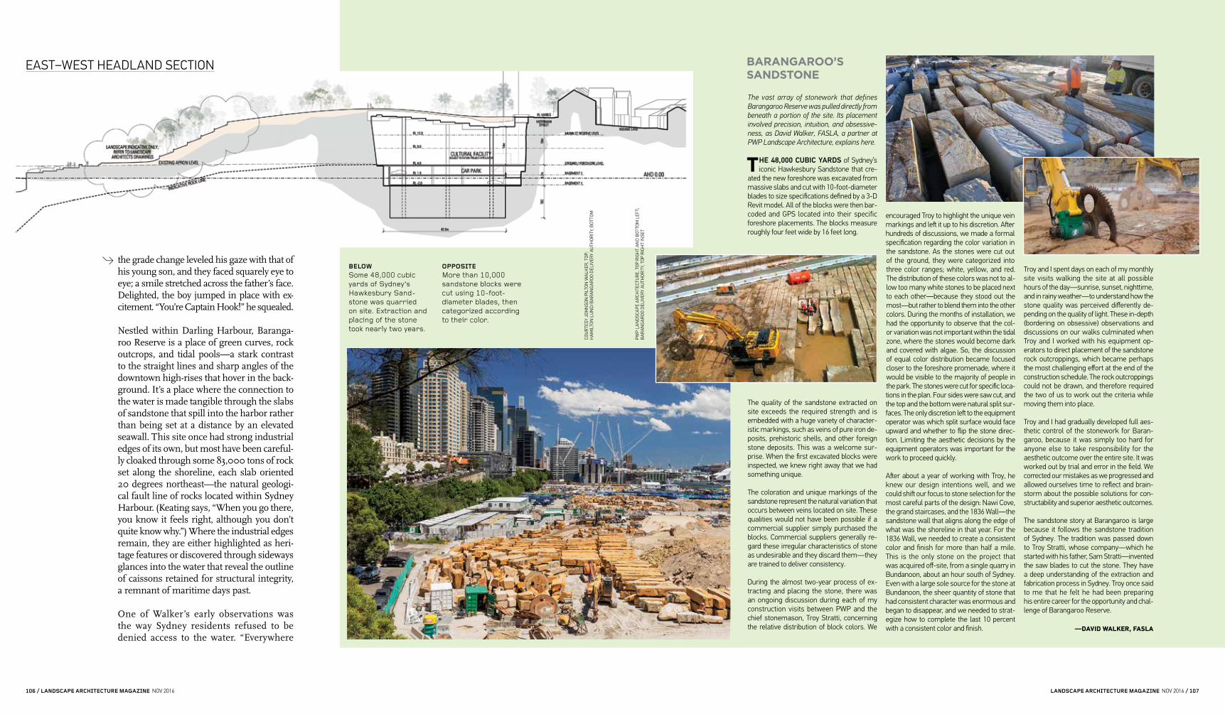
The vast array of stonework that defines Barangaroo Reserve was pulled directly from beneath a portion of the site. Its placement involved precision, intuition, and obsessive-ness, as David Walker, FASLA, a partner at PWP Landscape Architecture, explains here.
THE 48,000 CUBIC YARDS of Sydney’s iconic Hawkesbury Sandstone that cre-
ated the new foreshore was excavated from massive slabs and cut with 10-foot-diameter blades to size specifications defined by a 3-D Revit model. All of the blocks were then bar-coded and GPS located into their specific foreshore placements. The blocks measure roughly four feet wide by 16 feet long.
The quality of the sandstone extracted on site exceeds the required strength and is embedded with a huge variety of character-istic markings, such as veins of pure iron de-posits, prehistoric shells, and other foreign stone deposits. This was a welcome sur-prise. When the first excavated blocks were inspected, we knew right away that we had something unique.
The coloration and unique markings of the sandstone represent the natural variation that occurs between veins located on site. These qualities would not have been possible if a commercial supplier simply purchased the blocks. Commercial suppliers generally re-gard these irregular characteristics of stone as undesirable and they discard them—they are trained to deliver consistency.
During the almost two-year process of ex-tracting and placing the stone, there was an ongoing discussion during each of my construction visits between PWP and the chief stonemason, Troy Stratti, concerning the relative distribution of block colors. We
encouraged Troy to highlight the unique vein markings and left it up to his discretion. After hundreds of discussions, we made a formal specification regarding the color variation in the sandstone. As the stones were cut out of the ground, they were categorized into three color ranges; white, yellow, and red. The distribution of these colors was not to al-low too many white stones to be placed next to each other—because they stood out the most—but rather to blend them into the other colors. During the months of installation, we had the opportunity to observe that the col-or variation was not important within the tidal zone, where the stones would become dark and covered with algae. So, the discussion of equal color distribution became focused closer to the foreshore promenade, where it would be visible to the majority of people in the park. The stones were cut for specific loca-tions in the plan. Four sides were saw cut, and the top and the bottom were natural split sur-faces. The only discretion left to the equipment operator was which split surface would face upward and whether to flip the stone direc-tion. Limiting the aesthetic decisions by the equipment operators was important for the work to proceed quickly.
After about a year of working with Troy, he knew our design intentions well, and we could shift our focus to stone selection for the most careful parts of the design: Nawi Cove, the grand staircases, and the 1836 Wall—the sandstone wall that aligns along the edge of what was the shoreline in that year. For the 1836 Wall, we needed to create a consistent color and finish for more than half a mile. This is the only stone on the project that was acquired off-site, from a single quarry in Bundanoon, about an hour south of Sydney. Even with a large sole source for the stone at Bundanoon, the sheer quantity of stone that had consistent character was enormous and began to disappear, and we needed to strat-egize how to complete the last 10 percent with a consistent color and finish.
Troy and I spent days on each of my monthly site visits walking the site at all possible hours of the day—sunrise, sunset, nighttime, and in rainy weather—to understand how the stone quality was perceived differently de-pending on the quality of light. These in-depth (bordering on obsessive) observations and discussions on our walks culminated when Troy and I worked with his equipment op-erators to direct placement of the sandstone rock outcroppings, which became perhaps the most challenging effort at the end of the construction schedule. The rock outcroppings could not be drawn, and therefore required the two of us to work out the criteria while moving them into place.
Troy and I had gradually developed full aes-thetic control of the stonework for Baran-garoo, because it was simply too hard for anyone else to take responsibility for the aesthetic outcome over the entire site. It was worked out by trial and error in the field. We corrected our mistakes as we progressed and allowed ourselves time to reflect and brain-storm about the possible solutions for con-structability and superior aesthetic outcomes.
The sandstone story at Barangaroo is large because it follows the sandstone tradition of Sydney. The tradition was passed down to Troy Stratti, whose company—which he started with his father, Sam Stratti—invented the saw blades to cut the stone. They have a deep understanding of the extraction and fabrication process in Sydney. Troy once said to me that he felt he had been preparing his entire career for the opportunity and chal-lenge of Barangaroo Reserve.
—DAVID WALKER, FASLA
the grade change leveled his gaze with that of his young son, and they faced squarely eye to eye; a smile stretched across the father’s face. Delighted, the boy jumped in place with ex-citement. “You’re Captain Hook!” he squealed.
Nestled within Darling Harbour, Baranga-roo Reserve is a place of green curves, rock outcrops, and tidal pools—a stark contrast to the straight lines and sharp angles of the downtown high-rises that hover in the back-ground. It’s a place where the connection to the water is made tangible through the slabs of sandstone that spill into the harbor rather than being set at a distance by an elevated seawall. This site once had strong industrial edges of its own, but most have been careful-ly cloaked through some 83,000 tons of rock set along the shoreline, each slab oriented 20 degrees northeast—the natural geologi-cal fault line of rocks located within Sydney Harbour. (Keating says, “When you go there, you know it feels right, although you don’t quite know why.”) Where the industrial edges remain, they are either highlighted as heri-tage features or discovered through sideways glances into the water that reveal the outline of caissons retained for structural integrity, a remnant of maritime days past.
One of Walker’s early observations was the way Sydney residents refused to be denied access to the water. “Everywhere
EAST–WEST HEADLAND SECTION
BELOW Some 48,000 cubic yards of Sydney’s Hawkesbury Sand-stone was quarried on site. Extraction and placing of the stone took nearly two years.
OPPOSITE More than 10,000 sandstone blocks were cut using 10-foot-diameter blades, then categorized according to their color.
COU
RTE
SY J
OH
NSO
N P
ILTO
N W
ALK
ER, T
OP;
H
AM
ILTO
N L
UN
D/B
AR
AN
GA
RO
O D
ELIV
ERY
AU
THO
RIT
Y, B
OTT
OM
PWP
LAN
DSC
APE
AR
CHIT
ECTU
RE,
TO
P R
IGH
T A
ND
BO
TTO
M L
EFT;
B
AR
AN
GA
RO
O D
ELIV
ERY
AU
THO
RIT
Y, T
OP
RIG
HT
INSE
T
BARANGAROO’S SANDSTONE
→

LANDSCAPE ARCHITECTURE MAGAZINE NOV 2016 / 109108 / LANDSCAPE ARCHITECTURE MAGAZINE NOV 2016
around the harbor where people attempted to fence off the waterfront, everybody just jumps over the fence and they fish. The kids go into the tidal pools. There’s a whole water-front life of the modern Sydneysider,” Walker says. It was obvious that issues of waterfront access and movement around the periphery of the site needed to take priority. But under-standing how to shape and reconstruct a new headland around which to choreograph this activity was another challenge.
Because there were no surveys of the original headland, the design team studied historic maps and French landscape paintings of the area. From these, computer models were gen-erated that layered the terrain into different shapes and gradients. Existing rock outcrops on the seabed floor were also roughly mapped and archaeologists consulted to better under-stand the geologic processes that had affected the headlands over time. Based on this research, the shape of the headlands approximately
ABOVE, TOP TO BOTTOM A 3-D rendering of the foreshore; construction; and final stone placement at shoreline.
OPPOSITE Construction of the Cutaway, Barangaroo’s cultural center, which has capacity for 5,500 people.
COU
RTE
SY J
OH
NSO
N P
ILTO
N W
ALK
ER, A
BO
VE L
EFT;
HA
MIL
TON
LU
ND
/BA
RA
NG
AR
OO
DEL
IVER
Y A
UTH
OR
ITY,
OPP
OSI
TE

LANDSCAPE ARCHITECTURE MAGAZINE NOV 2016 / 111110 / LANDSCAPE ARCHITECTURE MAGAZINE NOV 2016
The soil formula for Barangaroo Reserve was designed to support the extensive plantings of native vegetation on the site. Simon Leake, the principal soil scientist at SESL Australia, which acted as the project’s main soil con-sultant, explains how his team developed the formula. This narrative originally appeared on the website of SESL and has been adapted and updated.
THE BARANGAROO HEADLAND PARK landscape was planned to use almost
completely recycled resources to make soils suitable for the sensitive Sydney sandstone flora and the public park turf areas. The concept was first used at Sydney’s Olympic Parklands, where crushed sandstone, an abundant natural recycled resource in Sydney, was successfully used to create soil profiles for bushland regeneration.
Building on that experience, our firm of soil scientists, SESL Australia, came up with a concept design for the completely recon-structed soils needed for the Headland Park at the early detailed design phase. This original concept is shown in Figure 1 (above right).
In this concept, the main materials to be used were crushed sandstone originating from building excavations in Barangaroo South commercial developments, recycled sand from building excavations, recycled green garden waste compost (produced from “green bin” and council drop-off garden waste collections), and composted wood mulch screened from green garden waste collections.
These commonly available recycled resourc-es could be used to make the mulch layer or “O” (for organic) horizon, analogous to the forest litter layer; the topsoil, or A horizon, a well-drained sandy soil containing nutri-ents, organic matter, and biological life; and the subsoil, or B horizon, a well-drained, water-holding layer for root anchorage and moisture reserve.
The thing we did not know was how much compost and fertilizer to put into the A ho-rizon, or topsoil layer. We knew that Sydney sandstone soils were so poor that the early settlers failed to grow adequate crops at the original Farm Cove gardens. We also know that if sandstone flora is fertilized or affected by nutrient-laden urban stormwater runoff, it suffers dieback and disease problems.
To answer this question, we did some field research in areas of intact sandstone flora to look at the natural Kandosol or “yellow earth” soil characteristic of sandstone country. We examined the profile and measured the levels of nutrients and general soil chemistry. We found strongly acidic pHs of 4.5 to 5.5, astound-ingly low levels of phosphorus—around 25 mg/kg of total phosphorus in sandstone rock and around 60 to 80 mg/kg in the “biolayer” or topsoil horizon, some of the lowest levels in the world. Calculations showed that only around 10 percent by volume of green waste compost would be required to achieve this.
In a series of pot trials growing a range of sandstone flora, we determined that the best range was, by volume, 5 percent compost for the very sensitive sandstone heath areas, 10 percent for the eucalyptus and woodland areas, and 20 percent for the turf and fig trees in the recreational areas.
The compost provides all the nutrients need-ed, apart from nitrogen. Just 5 percent by volume of compost is sufficient to establish a sandstone heath and scrub with no other fertilizers needed. Subsoil needs no organic matter and is even lower in nutrients.
We now had the soil profile concept and had calibrated and measured how much nutrition each planting needed. All we now had to do was finalize the cross sections. An early diagram of the sandstone terrace facsimile (opposite) illustrates how this was done so contractors tendering on the project could see how it was to be constructed.
The landscape belowground, or the soil land-scape, at Barangaroo was carefully worked out to mimic the natural soil profile and thus support a vegetation type with unique re-quirements for healthy growth. It does so by using almost 100 percent recycled ma-terial sourced from in and around Sydney from building sites, excavations, sand and glass recyclers (“glass sand,” made from crushed recycled glass, constituted some of the sand requirement), and, of course, the garden and green waste produced by Sydney households.
The concept was installed pretty much as de-signed, although it proved hard to get all the recycled materials needed. In the subsoils, we used recycled crushed glass sand, but in the topsoils we did have to use some quarried sand. All the crushed sandstone was recycled from both the Barangaroo excavations as well
as (and this is an advantage of working with the large construction companies) other sandstone from excavations all over Sydney, carefully screened and tested for compliance with the specifications. We achieved a level of about 80 percent recycled materials in the end—not bad.
The work has totally vindicated the extremely low nutrient requirements of this unique veg-etation assemblage. Almost no fertilizer has been used since its establishment—a little urea to overcome nitrogen drawdown, some potassium to replace losses from heavy rain-fall (it’s very soluble), some iron sulphate to acidify the pH, and some manganese on a couple of the very touchy species. Five per-cent compost provides all the nutrients the heath components require. It really stunned me and gave me a new respect for this in-credibly tenacious vegetation. It is truly as-tounding, as a soil scientist, to know that a complex stratified forest community can develop on a geology (Hawkesbury Sand-stone) with only 20 to 25 parts per million of phosphorus in it. This would have to be the lowest phosphorus parent material on Earth.
The research performed by the Baranga-roo Delivery Authority and its contractors resulted in two published scientific papers on the nutrition of native plants, making the Headland Park very much a “Headland” project—not just producing a beautiful place and displaying our unique flora, but also extending the knowledge of how to restore and rebuild a vegetation type that is part of the character of Sydney and its harbor.
Simon Leake is managing director and principal consultant at SESL Australia.
A HYPERLOCAL SOIL RECIPE
reflects the 1836 shoreline. This was affirmed when an old slipway from the 19th century was uncovered during construction.
Once the shape of the headland had been de-termined, the next challenge was to construct the steep 60-foot cliffs in a way that made them look like an approximation of nature without taking it to the level of Disneyland. So Walker proposed to Keating that the site be designed using a naturalistic philosophy. “I explained that naturalistic is a term which doesn’t describe nature, but it describes the nature of nature. You’re not copying nature; you’re representing it,” Walker says. “And for a long time Paul would say, ‘Let’s talk about that again . . . that was interesting.’” Keating jokes that Walker was taught naturalism at university, but in his decades of practice never found a client who wanted to use it—until Walker met him.
It was important that the shape of the head-land facilitated connections along the water-front and Hickson Road (the original main road leading to the shipyard), but it also needed to be high enough to link back into the city grid. “The goal was to have a seam-less connection, so no matter where you en-tered, you would form part of the city at that elevation,” Walker says. Of particular concern was to connect the broken streets of Millers Point, a residential community whose rug-ged ridgeline and high promontory were originally the site of wooden windmills, but were later sheared off during excavation of the headland in the late 1800s and replaced with terrace houses for workers employed at the docks below. For decades, residents in the town houses here—many of which were low-income government housing—only ↘
BOTTOM Construction of the terraced hill.
FIGURE 1: THE BARANGAROO ANTHROPOSOL
O Recycled Wood Mulch
A1 50/50 Crushed Sandstone, Washed Sand, 10-20% Compost
A2 50/50 Crushed Sandstone, Washed Sand
B2 70/30 Crushed Sandstone Washed Sand
C Compacted Fill
Coir Mesh
75mm Depth Mulch
Segmental Retaining Wall System
Topsoil
Rear Profile Reduced to Provide Soil VolumeSubsoil
500mm Min Depth of Soil Required at Base of Wall
Mass Concrete Footing
Topsoil 100mm Below Top of WallTop Block to be Filled with Soil MixGeotextile at Base to Retain SoilSelect Fill Material (Crushed Sandstone)Drainage Material
Geogrid Network
SANDSTONE TERRACE
AD
AM
RO
BIL
LIA
RD
AN
D A
DR
IAN
PIL
TON
OF
JOH
NSO
N P
ILTO
N W
ALK
ER A
ND
BA
RA
NG
AR
OO
DEL
IVER
Y A
UTH
OR
ITY,
TO
P A
ND
OPP
OSI
TE T
OP;
HA
MIL
TON
LU
ND
/BA
RA
NG
AR
OO
DEL
IVER
Y A
UTH
OR
ITY,
BO
TTO
M

LANDSCAPE ARCHITECTURE MAGAZINE NOV 2016 / 113112 / LANDSCAPE ARCHITECTURE MAGAZINE NOV 2016
PLANTING PLAN — UNDERSTORY
PWP
LAN
DSC
APE
AR
CHIT
ECTU
RE,
TH
IS P
AG
E A
ND
OPP
OSI
TE
Acacia floribunda (White Sally wattle)
Acacia longifolia (Sallow wattle)
Acacia myrtifolia (Red-stemmed wattle)
Acacia terminalis (Sunshine wattle)
Acacia ulicifolia (Prickly Moses)
Acmena smithii (Lilly pilly)
Allocasuarina littoralis (Black she-oak)
Banksia marginata (Silver banksia)
Banksia robur (Swamp banksia)
Banksia serrata (Old man banksia)
Banksia spinulosa (Hairpin banksia)
Bauera rubioides (River rose)
Boronia ledifolia (Showy boronia)
Callicoma serratifolia (Black wattle)
Callistemon linearis (Narrow-leaved bottlebrush)
Ceratopetalum gummiferum (New South Wales Christmas bush)
Correa alba (White correa)
Correa reflexa (Common correa)
Cyathea australis (Rough tree fern)
Dillwynia retorta (Heathy parrot pea)
Dodonaea triquetra (Large-leaf hop bush)
Doryanthes excelsa (Gymea lily)
Elaeocarpus reticulatus (Blueberry ash)
Eriostemon australasius (Pink wax flower)
Exocarpos cupressiformis (Cypress cherry)
Glochidion ferdinandi (Cheese tree)
Grevillea buxifolia (Grey spider flower)
Grevillea linearifolia (Linear-leaf grevillea)
Grevillea sericea (Pink spider flower)
Hakea dactyloides (Finger hakea)
Hakea teretifolia (Needlebush)
Hibiscus tiliaceus (Cottonwood hibiscus)
Isopogon anemonifolius (Broad-leaf drumsticks)
Lambertia formosa (Mountain devil)
Leptospermum juniperinum (Prickly teatree)
Macrozamia communis (Burrawang)
Melaleuca hypericifolia (Hillock bush)
Melaleuca nodosa (Prickly-leaved paperbark)
Notelaea longifolia (Large mock-olive)
Olearia tomentosa (Toothed daisy bush)
Omalanthus populifolius (Native bleeding heart)
Persoonia levis (Broad-leaved geebung)
Pittosporum spp. (Cheesewood)
Telopea speciosissima (Waratah)
Tristaniopsis laurina (Water gum)
Westringia fruticosa (Coastal rosemary)

LANDSCAPE ARCHITECTURE MAGAZINE NOV 2016 / 115114 / LANDSCAPE ARCHITECTURE MAGAZINE NOV 2016
THE PLANTINGS at Barangaroo Reserve include more than 75,000 native trees
and shrubs. Of these plants, there are 84 species native to the Sydney Harbour area: 14 species of trees, palms, and tree ferns; 25 native ground covers, vines, grasses, and ferns; and 45 species of native shrubs, small trees, and cycads. The landscape architect and horticulturist Stuart Pittendrigh of Norcue led the planting regime for the site, working with PWP Landscape Architecture and the local firm of Johnson Pilton Walker.
Pittendrigh, who specializes in plants native to the Sydney region, mapped out seven dif-ferent vegetation zones on the 14-acre site: ridge top woodland, heath and scrub, open dry forest, tall moist forest, damp gully forest, waterfront, and headland. He shared a few observations on the process with LAM. (This exchange has been edited.)
LAM: You are said to have researched which plants were growing in the area when the First Fleet arrived from England in 1788. How hard was that to do? Are sources of informa-tion readily available?
SP: History indicates that the early Europeans who arrived in Sydney included botanists. Jo-seph Banks, Daniel Solander, and John White discovered and named many new plants that had never been seen before in England. Their findings were recorded, resulting in accurate records that are still retained today. The Sydney Royal Botanic Garden’s ecologists and botanists have continued research and recording of this fine work, which has resulted in many botanical reference documents that may be accessed.
LAM: How well do most of those plants or plant communities survive today? And how many of the species are endemic to a very small area around the harbor? Are any threatened or endangered?
SP: Remnants of the original plant discover-ies remain in small, undisturbed pockets around the harbor foreshore and survive naturally despite the city’s changing climate and environment. A small percentage of these indigenous plantings are classified as threatened species, but none are considered exclusively endemic to Sydney Harbour and its estuarine environments.
LAM: It’s said that you had a list of 31 items to ensure quality control among the plants. What are some of the tougher ones to satisfy?
SP: Self-supporting, good stem taper, crown symmetry, branch and stem inclusions, root direction, root ball occupancy, and height of the root crown.
LAM: So far you’ve seen a failure rate of about 1 percent of the plants—amazing. The norm, you say, is more like 10 percent to 15 percent. What will be the biggest mainte-nance challenges ahead as the park seasons and settles in?
SP: We will do annual soil testing that will determine the fertilizing program and the quantity and composition of fertilizer to suit the indigenous vegetation. There will be maintenance and irrigation from on-site retention storage for at least another 12 months, when consideration will be given to allowing the site to rely on natural rainfall events unless there are long or extensive periods of drought. We will control pests and disease, which at this stage of plant establishment are minimal. We’ll need to repair torn limbs from severe weather events and damage by park users. And there will be removal of invasive weed species.
SEVENTY-FIVE THOUSAND PLANTS
had a small stairwell leading from the top of the cliff face down 60 feet to the concrete apron of the former shipping dock. Now the residences have a stretch of open park-land spilling out from their front doors with magnificent ocean views, increasing not only their amenity but also their value: Many have marketed with a price of more than $4.5 mil-lion (AUD).
The existing harbor headlands had an un-derlying base of preexisting stone to support the sheer cliffs. Walker’s team did not have that to work with. They needed to achieve a vertical profile that provided structural stability without the benefit of existing geol-ogy. The solution was to establish a series of terraces made of hollow precast concrete units that were filled with aggregate and tied back into the hillside. The units were colored with a sepia finish to help them blend in as the plantings grew and provided greater coverage. Behind these walls, the intention had been to backfill using recycled fill from nearby development works—approximately 490,000 cubic yards’ worth. However, soil contamination issues significantly reduced the amount of dirt available for creating the mass of the headland. What resulted was the creation of the Cutaway, a 21,500-square-yard void within the belly of the headland to serve as Sydney’s largest function space and future cultural center.
With walls extending 60 feet high, the Cut-away is built up around the original cliff face of the shipping yard, where ventilation open-ings in the roof structure allow natural light to spill onto its roughened surface with great effect. However, this is where the charm of the space ends, as the rest of the interior is boxy and clad in enormous swaths of drab concrete, giving it the feel of (ironically) a shipping container warehouse rather than a space to host cultural events like the Venice Biennale. There had been an original proposi-tion for the Cutaway by JPW (a study separate from the work undertaken with PWP) that put forward a more sculptural and considered proposition toward the shape and function of the Cutaway. But it was a latecomer to the de-sign brief, and a more conservative approach was taken toward its construction, which saved on cost, but sacrificed the creation of what could have been one of Australia’s larg-est and most inspiring interior spaces.
The design of Barangaroo Reserve’s water-front was easily the most time-intensive part of the headland’s creation. Local Syd-ney stone yards were initially investigated to provide the sandstone, but that would have required carving by highly pressurized water jets to give the stones the desired naturalistic appearance. However, a fortuitous discovery was made when sandstone was found be-neath the Barangaroo site, and plenty of it.
ABOVE Grasses are among the native plants used at Barangaroo.
RIGHT A terrace planting.
BELOW The bush walk is defined by a Cor-Ten steel wall.
→
BR
ETT
BO
AR
DM
AN
PH
OTO
GR
APH
Y, T
HIS
PA
GE
AN
D O
PPO
SITE

LANDSCAPE ARCHITECTURE MAGAZINE NOV 2016 / 117116 / LANDSCAPE ARCHITECTURE MAGAZINE NOV 2016
PWP
LAN
DSC
APE
AR
CHIT
ECTU
RE,
OPP
OSI
TE; B
AR
AN
GA
RO
O D
ELIV
ERY
AU
THO
RIT
Y, R
IGH
T
BARANGAROO RESERVE — “CUTAWAY” REVEALED
Over the span of one year, 10,000 blocks about four feet wide and up to 16 feet long were strategically hewn from beneath the space of the Cutaway with the extraction pit laid out in the shape of the site’s required parking garage. Because of Sydney Har-bour’s geological fault line of 20 degrees northeast, the sandstone harvested from the site sheared naturally when hewn from this angle, providing a naturalistic rock face. No jet-spraying of the rocks would be needed.
Each of the extracted sandstone blocks was labeled, sized, and bar-coded to identify where it should go in the foreshore. This data was entered into a custom-made 12-D computer modeling program that mapped out the waterfront and ensured each indi-vidual block could be slotted into place like a giant 3-D puzzle, while also certifying that fall heights and joint widths met Australian safe-ty standards. Initially, the blocks were limited to 75 different sizes, but this number was increased to more than 200 as it afforded ↘
BELOW The entire existing cliff face forms the eastern wall of the Cutaway.