Embed Size (px)
Citation preview
' .
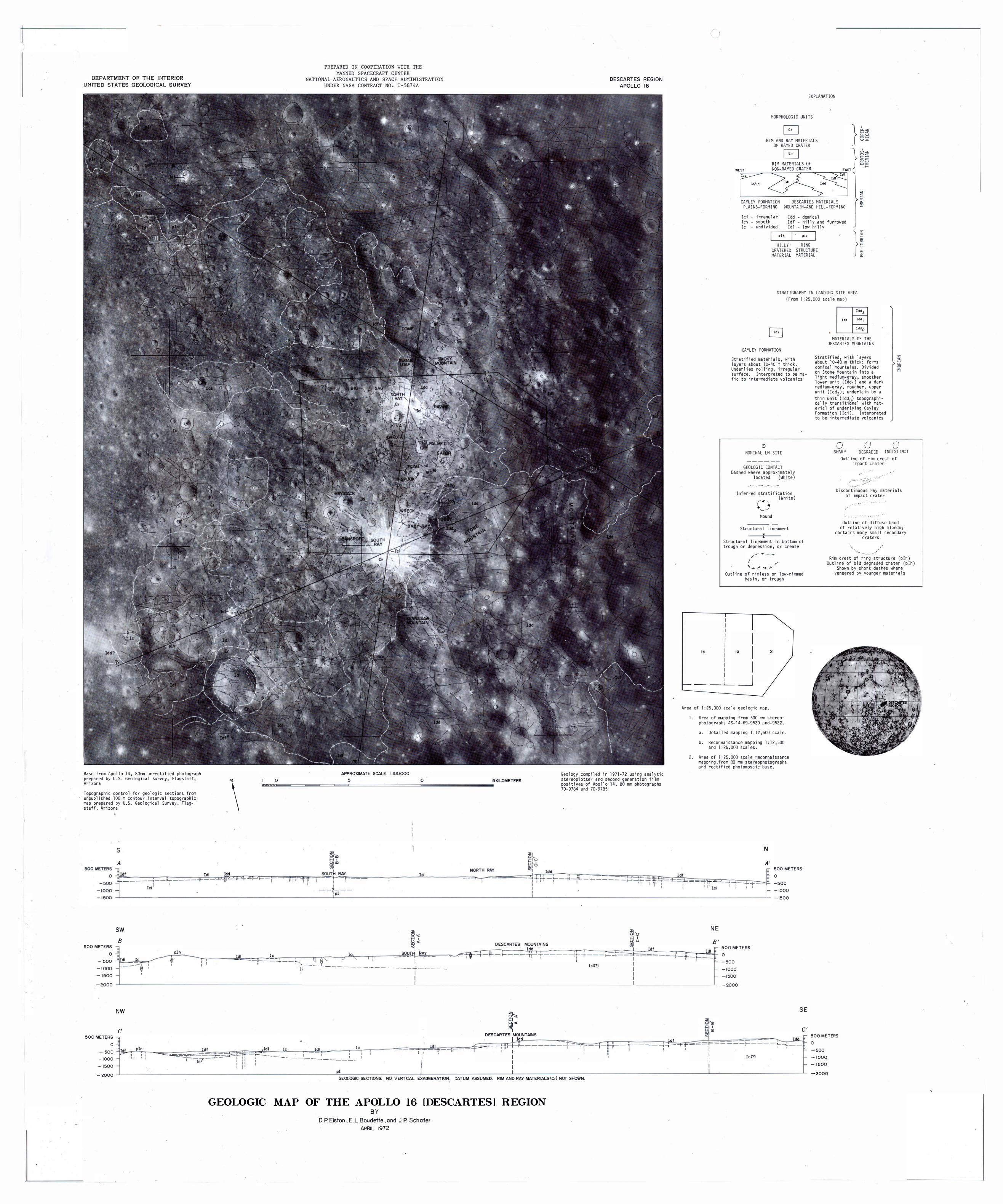
DEPARTMENT OF THE INTERIOR UNITED STATES GEOLOGICAL SURVEY
Base from Apollo 14. Bomm unrectified photograp� prepared by U.S. Geological Survey, Flagstaff, Arizona
Topographic control for geologic sections from unpublished 100 m contour interval topographic map prepared by U.S. Geological Survey, Flagstaff, Arizona
SW
B 500 METERS -,
0 �
-500 - 1000 -1500
-2000
500 METERS 0
-500 - 1000
-1500
-2000
ldl Ic
NW
c .., _,
� _lllr ·
,, - . '
-
plh
\
Tdl
PREPARED IN COOPERATION WITH THE MANNED SPACECRAFT CENTER
NATIONAL AERONAUTICS AND SPACE ADMINISTRATION UNDER NASA CONTRACT NO. T-5874A
APPROXIMATE SCALE I' 100,000
Wffi��0
========� ==�==�==�5c===================�I 0=====================-15KILOMETERS
lc
ldl Ic
51·<[ >=I 1 ��<I "'I .
Ic SOUTH FlAY ....._ 'II Ill ' ' ' ' ' -
I .
T I 'l--.'.:._ .l._ II . -------------- + ---- -
1 I
. Tdl lc ldl I ' "
DESCARTES MOUNTA I NS Idd
t-- +---t�-r ' '
�I-<[ i=l I ��<[ "'I
DESCARTES MOUNTAINS I Idd
I I ,_ _ I I
I I I '
--- ----- ------
pi I
DESCARTES REGION APOLLO 16
Geology compiled in 1971-72 using analytic stereoplotter and second generation film positives of Apollo 14, 80 mm photographs 70-9784 and 70-9785
zl-Qu >-1 I frliU "'I _JJjf
:t-+ 1-'--+ =l= I I
lei{'?) I I I
:
....;
I 0 I ' '
-+ ldf
i'
GEOLOGIC SECTIONS. NO VERTICAL EXAGGERATI ON. DATUM ASSUMED. RIM AND RAY MATERI ALS(Cr) NOT SHOWN.
GEOLO GIC MAP OF THE APOLLO 16 !DESCARTES! REGION BY
D.P. Elston, E .L.Boudette ,and J. P Schafer APRIL 1972
EXPLANATION
MORPHOLOGIC UNITS
RIM AND RAY MATERIALS OF RAYED CRATER
D
Ic/Ici
CAYLEY FORMATION DESCARTES MATERIALS PLAINS-FORMING MDUNTAII�-AND HILL-FORMING
lei irreaular Idd - domical Ics smooth Ic undivided
Idf - hilly and furrowed Idl - law hilly
I � pir H!LLY'
CRATERED MATER!AL
R!NG STRUCTURE MATER!AL }!
STRATIGRAPHY !N LANDING SITE AREA
(From 1;25.000 scale map )
CAYLEY FORMATION
Stratified materials. with layers about 10-40 rn thick. Underlies rolling. irregular surface, Interpreted to be mafic to intermediate volcanics
0 NOmNAL LM SITE
GEOLOGIC CONTACT Dashed where approximately
located (White ) .. . .. . .. .
Inferred stratification (White )
Mound
Structural lineament
Structural lineament in bottom of trough or depression, or crease
I y '-:""-r'<.......Y Outline of rimless or low-rimmed
basin, or trough
I lb Ia I 2
I _l__j
ldd2 ldd Iddt
Idd0
MATERIALS OF THE DESCARTES MOUNTA!NS
Stratified. with layers about lD-40 m thick; forms domical mountains. Divided on Stone Mountain into a light medium-grar . smoother lower unit ( !dd1) and a dark medium-gray. rougher. upper unit (Idd2
) ; underlain by a
thin unit ( !ddgl topographi-cally transiti nal with mat-erial of underlying Cayley Formation (Ici ). Interpreted to be intermediate volcanics
0 rl L.-SHARP DEGRADED
( . \ -... . ..i !NDIST!tiCT
Outline of rim crest of impact crater
.· · · · · . · · · ·
.•... , .
Discontinuous ray materials of impact crater
. . . . · .
Outline of diffuse band of relatively high albedo;
contains many small secondary era ters
Rim crest of ring structure (plr ) Outline of old degraded crater (plh )
Shown by short das�es w�ere veneered by younger materials
Area of 1:25.000 scale geologic map.
..._ ,.
-r,
1. Area ·of mapping from 500 rrm stereophotographs AS-14-69-9520 and-9522.
a. Detailed mapping 1:129500 scale.
b. Reconnaissance mapping 1:12,500 and 1:25,000 scales.
2. Area of 1:25,000 scale reconnaissance mapping.from 80 mm stereophotographs and rectified photomosaic base.
N
A' 500 METERS
r
..L ' ' -,--'
NE
B' � 500 METERS ldl
I I I
l
'-
-
-
0 -500
-1000 -1500
-2000
-� '
jc(?)
=- 0 -500
- - 1000 -1500
SE
C'
ldli .,.-�� e-' '
F-f-f-
500METERS 0 -500 -1000 -1500
-2000