Embed Size (px)
Citation preview
MICHIGAN GEOLOGICAL AND BIOLOGICAL SURVEY
Publication 11. Geological Series 8.
GEOLOGICAL REPORT ON
ARENAC COUNTY
BY W. M. GREGORY
PUBLISHED AS A PART OF THE ANNUAL REPORT OF THE BOARD OF GEOLOGICAL AND BIOLOGICAL SURVEY FOR
1911
1912 WYNKOOP HALLENBECK CRAWFORD CO., STATE PRINTERS
LANSING, MICHIGAN
BOARD OF GEOLOGICAL AND BIOLOGICAL SURVEY, 1911.
EX OFFICIO:
THE GOVERNOR OF THE STATE, HON. CHASE S. OSBORN, President.
THE SUPERINTENDENT OF PUBLIC INSTRUCTION, HON. L. L. WRIGHT, Secretary.
THE PRESIDENT OF THE STATE BOARD OF EDUCATION, HON. D. M. FERRY, JUNIOR.
DIRECTOR, R. C. ALLEN.
SCIENTIFIC ADVISORS.
Geologists.—Dr. L. L. Hubbard, Houghton; Prof. W. H. Hobbs, Ann Arbor; Prof. W. H. Sherzer, Ypsilanti
Botanists.—Prof. E. A. Bessey, East Lansing; Prof. F. C. Newcomb, Ann Arbor.
Zoologists.—Prof. W. B. Barrows, East Lansing; Prof. J. Reighard, Ann Arbor; Dr. Bryant Walker, Detroit.
CONTENTS. CHAPTER I. HISTORICAL AND GEOGRAPHICAL INTRODUCTION............................................................... 3
Indians. .......................................................................... 3 The early government.................................................... 3 The organization............................................................ 3
First organization of county government........................4 Geographical location. ...................................................4 The growth in population................................................4
CHAPTER II. PREVIOUS GEOLOGICAL WORK. ..........4 The early surveys...........................................................4 Alexander Winchell. .......................................................5 Coal explorations. ..........................................................7 Carl Rominger. ...............................................................7 Recent surveys. .............................................................7 Alfred C. Lane. ...............................................................8 Miscellaneous. ...............................................................8
CHAPTER III. CLIMATE. .................................................8 The available records.....................................................8 The temperature.............................................................8 The frosts. ......................................................................9 The rainfall....................................................................10 The winds. ....................................................................10
CHAPTER IV. THE GEOLOGICAL COLUMN...............11 Introduction...................................................................11 The Pleistocene. ..........................................................12 The general features of the bed rock. ..........................13 The Saginaw coal series. .............................................13 The Parma Sandstone. ................................................13 The Upper Grand Rapids or Bayport Limestone..........14 The Lower Grand Rapids. ............................................14 Tower strata. ................................................................14
CHAPTER V. PALAEOZOIC OR BED ROCK GEOLOGY.......................................................................14
Saginaw coal series. ....................................................14 Distribution............................................................. 14 Outcrops ................................................................ 14 Early operations along the Rifle River ................... 15
Maxville or Bayport Limestone (Upper Grand Rapids).17 Distribution............................................................. 17 Point Au Gres ........................................................ 18 The Griffin Quarry.................................................. 18 The miscellaneous outcrops.................................. 19
The Lower Grand Rapids. ............................................20 Distribution............................................................. 20 The Gypsum beds ................................................. 21 County line outcrop................................................ 21 The Turner Gypsum bed ....................................... 22
The Napoleon Sandstone. ...........................................22 Distribution............................................................. 22 Value of the Napoleon Sandstone......................... 23
CHAPTER VI. PLEISTOCENE GEOLOGY. GLACIAL HISTORY. ........................................................................23
Introduction...................................................................23 Glacial deposits. ...........................................................24 The Port Huron Morainic System.................................24 The Alcona Moraine. ....................................................25 Lake Features:. ............................................................25
Lake Warren .......................................................... 25
Publication 11, Geological Series 8 – Page 1 of 55

Publication 11, Geological Series 8 – Page 2 of 55
The Sterling Spit in Lake Warren...........................26 The Pinnacle Hill Delta...........................................27 The Lower Beach...................................................27 The Grassmere Beach...........................................28 The Elkton Beaches...............................................28 Lake Algonquin, Algonquin Beaches. ....................29
Southern Part of Saginaw Bay. ..................................29 Bay-Arenac County Line.............................................29 Saganing and Worth...................................................29 King's Corners. ...........................................................30 Arenac Postoffice. ......................................................30 Omer. .........................................................................30 Au Gres and Point Lookout. .......................................31 Alabaster, Iosco County. ............................................31 Twining and Au Gres Swamp. ....................................31
CHAPTER VII. WATER RESOURCES. PART I HYDROLOGY. ................................................................ 32
Water Supply:. ............................................................. 32 The wells................................................................32 Tables of the flowing wells.....................................32 Tables of the shallow and non-flowing wells. ........32 Quantity of the water..............................................33 Rock wells..............................................................34 Flowing wells..........................................................34 The flowage and pressure. ....................................35 Quality of the water. ...............................................36 Well temperatures..................................................37 The uses ................................................................37 Flowing wells at Twining and Turner. ....................38
PART II.—HYDROGRAPHY. ......................................... 40 Water Power:. .............................................................. 40
The Rifle river.........................................................40 The Pine river.........................................................41 Saganing creek ......................................................41 The Au Gres river...................................................41
CHAPTER VIII. ELEVATIONS. ..................................... 42 Introduction.................................................................. 42 Michigan Central Railroad ........................................... 42 Detroit and Mackinac Railroad (Main Line) ................. 43 Detroit and Mackinac Railroad (Prescott Branch) ....... 43 Detroit and Mackinac Railroad (Au Gres Branch) ....... 43 Miscellaneous elevations............................................. 43 Drain elevations........................................................... 43 Miscellaneous beach levels......................................... 44 Water power levels ...................................................... 44 Elevations of streams at railroad bridges .................... 44
CHAPTER IX. THE SOIL AND THE SOIL PRODUCTS.44 The value of the soils................................................... 44 Formation of the soils. ................................................. 45 The glacial period and the soils. .................................. 45 Kinds of soils. .............................................................. 46
Sand and gravels ...................................................46 The sand soil products...........................................47 The jack pine flora..................................................47 Clay soils................................................................48 The muck or peat Soils ..........................................49 Loam ......................................................................50
Silt.......................................................................... 50 CHAPTER X. ECONOMIC RESOURCES AND RAW MATERIALS. ...................................................................50
Introduction...................................................................50 Sand .............................................................................50 Gypsum. .......................................................................51 Limestone.....................................................................51 The coal........................................................................52 The clay........................................................................53 The water resources. ...................................................54 The soils. ......................................................................54
LIST OF ILLUSTRATIONS.
PLATES. Plate IIIA. Knob and trail effect in Griffin’s Quarry north of
Omer, Michigan..............................................................19
B. Quarry at Omer, Michigan. ...............................................19
Plate IVA, B. Banks of the Rifle river showing contrast of sand above, and clay below with steep gullied slope..............45
Plate VA. Burt’s lime kiln at Omer, Michigan.........................51
B. Stripping of the Burt quarry northeast of Omer, Michigan. 51
Plate VI. Coal series in bed of Rifle river at Omer, Michigan. 52
FIGURES. Fig. 1. Climatic chart. ..............................................................8
Fig. 2. Geological colum in Arenac county ............................12
Fig. 3. Geological section from East Tawas to Standish. ......12
Fig. 4. Geological section from Culver to Lake Huron. ..........13
Fig. 5. Early drainage of the Rifle and Au Sable Rivers southward through the Greenwood swamp to the Tittabawassee. ...............................................................25
Fig. 6. A later stage of the drainage shown in Fig. 5. ............25
Fig. 7. Lake Warren in Arenac county. ..................................25
Fig. 8. Profile of beaches at Alabaster. .................................28
Fig. 9. Section of back swamp at Algonquin ridge near south quarter post of Sec. 24, Lincoln township. .....................28
Fig. 10. Nipissing at King’s corners. ......................................28
Fig. 11. Algonquin north from King’s corners (Sec. 5)...........28
Fig. 12. Profile of Algonquin beach. ......................................28
Fig. 13. Profile west from King’s corners, “High Banks”. .......28
Fig. 14. Profile east from Omer. ............................................28
Fig. 15. Profile from Lake Huron to Bluff (two miles south of Tawas City) ....................................................................28
Fig. 16. Profile from Lake Huron west (one mile south of Tawas City). ...................................................................28
Fig. 17. Vinegar Hill...............................................................28
Fig. 18. Flowing wells of Twining...........................................38
LETTER OF TRANSMITTAL. To the Honorable the Board of Geological and Biological
Survey of the State of Michigan:
Publication 11, Geological Series 8 – Page 3 of 55
Governor Chase S. Osborn, President. Hon. D. M. Ferry, Jr., Vice President. Hon. L. L. Wright, Secretary.
Gentlemen:—I transmit herewith Publication 11, Geological Series 8, a report on the geology of Arenac county by Professor W. M. Gregory of Cleveland, Ohio. Professor Gregory's studies in Arenac county were completed several years ago under the direction of Dr. A. C. Lane, formerly State Geologist. The removal of Professor Gregory and Dr. Lane from the state and other circumstances have delayed the publication of the report.
Very respectfully, R. C. ALLEN, Director.
CHAPTER I. HISTORICAL AND GEOGRAPHICAL
INTRODUCTION.1
INDIANS. The Indian legends contain an account of a tribe called the Banks or Sacs, who were the original inhabitants of the country above Saginaw Bay. This once powerful tribe was destroyed by the Chippewas and the Ottawas in a series of battles on the Au Sable river, Pine river and Skull island, the latter of these places being near the present site of South Bay City. The term Saginaw is derived from the Indian term O-sank-e-non, meaning "the land of the Sanks." After the extermination of the Banks, the Chippewas held the country from Thunder bay to Saginaw. The AuSable river was a favorite canoe route through a beautiful country, and the short portages made an easy connection with the headwaters of the Tittabawassee. Many battles were fought at these advantageous portages, and on the high river bluffs, mounds of charred wood show how the prominent points were used for signal places and camping sites. On the headwaters of the Rifle river east of West Branch station, a strong earthwork was built on a bluff overlooking the river, and on its ruins white pines a foot or more in diameter are growing. Small burial mounds of various designs are found on the east shore of Bush lake in Ogemaw county and chipping grounds have been located at Point AuGres, where the flint nodules from the limestone were worked into arrow heads and various useful implements. Burial grounds were found at AuGres village, west of Pine River station, near Saganing, at Tawas Point and Indian Isle on the Au Sable. 1References. History of the Lake Huron shore, H. R. Page & Co., 1883, (History of Bay county, pp. 1-107). The separation of Arenac
county is mentioned at the end. Michigan, T. M. Cooley, 1885. See also papers by Harlan I. Smith. History of Michigan by J. H. Lanman, 1830.
THE EARLY GOVERNMENT. The great county of Michilimackinac, with its seat on the island of Mackinac, embracing a large part of the northern portion of the Lower Peninsula and all the Upper Peninsula of Michigan, was the first governmental organization over this region. Many of the early geographies and histories of our country give maps and descriptions referring to some of the main rivers and bays along the Huron shore. Chief among the writers was Henry Schoolcraft, Indian Commissioner, stationed for a time at Mackinac Island, and the father of many Indian treaties. The various changes of government before the organization of Michigan as a state are familiar to students of history. The following tabulation traces in outline these changes:
2Surrender of Detroit. 3Surrender of Drummond Island.
THE ORGANIZATION. The organization of Michigan Territory in 1805 was the beginning of a definite form to Arenac county. At this time the territory was governed by a council and governor appointed by the president. This council on March 2, 1831, enacted the following law:4
"Sec. 2. That the country included within the following limits, to wit:
East of the line between ranges 2 and 3 east, north of the line between townships 16 and 17 N., south of the line between townships 20 and 21 N., and west of the shores of Saginaw bay and Lake Huron, be and is hereby set off into a separate county by the name of Arenac.”5
By this act the county at that time included more land than it does at the present time, as all of the T. 17 N., Rs. 3 and 4 E., and also T. 18 N., R. 3 E., then were in Arenac. This was before Bay county was organized, with which at the present time the officials of Arenac county are contending for the possession of Gibson township (T. 18 N., R. 3 E.)6 The county now contains about 356 square miles, being one of the smallest counties of the state.
An old map of Michigan in possession of the State Geological Survey, supposed to have been published by James H. Lanman in 1839, shows Arenac county as described in the above act of 1831, Bay county being unknown at that time. The same is true on a map of the United States, published by Louis Robinson & Co.,
Akron, Ohio, in 1837. On March 15, 1841, Arenac was attached to Saginaw county, and in February, 1853, was taken from Saginaw county and given to Midland county. 4Terr. Law, Vol. Ill, p. 872.
Publication 11, Geological Series 8 – Page 4 of 55
5Michigan Pioneer and Historical Collections, Vol. I, p. 99. 6The State Supreme Court has declared the act of the legislature, making Gibson township a part of Bay county, unconstitutional.
FIRST ORGANIZATION OF COUNTY GOVERNMENT.
In February, 1857, the increasing population of Bay City gave the city enough political strength to form Bay county by taking Arenac and parts of Midland and Saginaw. This was accomplished only after a bitter struggle in the legislature and through the courts. After being part of Bay county for 26 years, Arenac was again organized as a county in April, 1883, with Omer as the county seat, which was changed to Standish in 1892.
GEOGRAPHICAL LOCATION. The county's northern limit does not extend beyond T. 20 N., and to the south it does not reach beyond T. 18 S., in the ranges 19 and 20. It extends from, R. 3 E. to Lake Huron in the upper tier of towns; in R. 18 N., it extends only from R. 4 E. to the lake, T. 18 N., R. 3. E. belonging to Bay county. The latitude and longitude of only a few points in the county have been determined. Alexander Winchell gave Standish a longitude of 83° 57' and a latitude of 43° 58’. The following locations were determined by the Survey7 of the north and northwest lakes in 1860:
7Annual report of the Survey for Northern and Northwestern lakes for 1860, p. 344.
THE GROWTH IN POPULATION. In the early days the population increased very slowly. The vast forests of pine offered at first but little attraction to the settlers, but when the Jackson, Lansing and Saginaw railroad (the Michigan Central) was completed to Standish, the value of the timber made the lands much desired and lumbering operations were very active. Many small towns which were active lumber centers have entirely disappeared with the timber. The county has grown slowly because the very nature of lumbering operations was to obtain as much as possible and leave no permanent improvements.
The rapid increase of population of 72.8 per cent from 1890 to 1900 was due primarily to timber operations and the natural decrease from 1900 to 1910 following the transfer to other regions of lumbering activities was 1.8 per cent for Arenac county. The population per square
mile is 25.8 but its distribution is quite irregular and influenced very distinctly by the character of the soil. The following table shows the population, organization, etc.
CHAPTER II. PREVIOUS GEOLOGICAL WORK.
THE EARLY SURVEYS. The early explorers found nothing in the forests of pine or the marshy plains at the mouths of the rivers to offer any advantage in trading or manufacture. The value of coal and gypsum was not recognized in the early days.
A map by Dr. Bigsby made in 18231, shows no trace of the large rivers of the county, and does not give an adequate idea of the size of Saginaw bay which bears the title of the Gulf of Saguina. Many of the early maps are of geographical interest rather than geological. Mr. Henry Schoolcraft in his "Narratives and Voyages," speaks of the severe storms encountered in crossing Saginaw bay, of the islands in its midst, and the highlands of the Au Sable.
From 1837 to 1842, a careful reconnaissance under the direction of Dr. Douglass Houghton, the first State Geologist, was made of the Saginaw region. The result of this effort was a report and a good map (never issued), which shows the character of the west shore of Saginaw bay from White Feather creek to near the present village of Alabaster in Iosco county.
On the map the Indian names of Sho-wes-que and Skin-quak-li-qui-uck are applied to Rifle river and Pine river respectively. The Au Gres river appears as Riviere Au Grais, and the name White-stone Point and Gravelly Point were applied as we now know them. In a pencil note apparently written on this map by some member of the Survey, opposite Whitestone Point, it states that the rock surface was just covered by water in 1842. A similar note appears opposite the mouth of the Au Gres river, stating the presence of rock on the bottom some distance out from the river's mouth. It seems quite likely that a mistake occurs here for no rock has been found in recent work, although a hardpan occurs in the river bottom, but one with experience would not mistake it for gypsum. It is probably an error of location, as gypsum does occur some 15 miles north of this place.
Publication 11, Geological Series 8 – Page 5 of 55
The following extracts from the Second Annual Report by Dr. Douglass Houghton reveal the general character of the geological formations:
"Gypsum, of a beautiful white color occurs in. the bed of the lake a little north of Point Au Grais river, but to what extent it is impossible to determine, for it is covered by several feet of water, which will effectually prevent the working of the bed." This is no doubt a reference to gypsum exposed at Plaster Bluff.
"The country north of the southern boundary of Arenac and east of the meridian, so far as examined, is on the whole but ill adapted to the purposes of agriculture, being chiefly composed of sandy ridges and intervening swales, and rising so gradually toward the central portions of the state as to leave he country extremely flat."
"A large part of the immediate shore of the lake is composed of marsh."
"An exception to the flatness of the country exists in an elevated district commencing on high hills a little south of Thunder Bay river, and stretching in a southwesterly direction towards the head of the Lake Michigan. This range at its commencement is usually known as the highlands of the Au Sable. These hills follow the line of bearing of the rock formation and no doubt extend diagonally completely across the state, forming a portion of the summit of the more northern part of the peninsula."
A slight glance at the map of our state will sufficiently explain the relations which Saginaw Bay of Lake Huron holds to the line bearing already mentioned." * * * * * * * * * "This great arm of that lake stretches in a southwest direction making a deep indentation in the peninsula and occupying a denuded space in the sandstone, just at that part where the latter comes in contact with the limestones of the north."
The present idea of the location of the Marshall sandstone and the Michigan Series does not bear out this statement.
"Thus while the southerly portions of the Bay are characterized by the appearance of abrupt, but low cliffs of sandstone which rocks may be traced in a southwesterly direction completely across the peninsula, the opposite, or northerly shore is not less marked by the occurrence of limerock which stretches in a like manner southwesterly to Lake Michigan. The limestone forms several of the headlands and small islands of Saginaw bay and Lake Huron and also occasionally appears in the beds of the streams giving rise to rapids near their places of embouchre."
"In proceeding northerly from the mouth of Saginaw river, limestone is first noticed forming the very extremity of Point Au Grais. Quarries have been opened here and a rough building stone obtained. It is of a compact structure, tolerably adapted to resist the action of the elements, and being situated as it is, in such a manner that the stones may be readily quarried and transported,
it is a point from which the country in the vicinity of Saginaw river may be more economically supplied with this character of stone, than from any other. By judicious selections, portions of it may be made use of for the manufacture of lime, but the great mass is of too siliceous a character, to admit of use for that purpose.”
In "A Michigan Geological Expedition"2 by Bela Hubbard, is given a description of a geological expedition in 1837 to this region in company with Dr. Houghton. It may be that the map above referred to was made at this time. In this narrative the following reference to the Michigan Series is made:
"In the interest of the scientific object of our tour I will here observe that near the Au Gres river we discovered, beneath the clear water of the bay, a bed of gypsum. Subsequently an outcrop of this mineral was found on the neighboring land and has long been quarried with profit." 1Reproduced in the Michigan Miner, Volume 3, No. 12, p. 11. 2"A Michigan Geological Expedition,” Michigan Pioneer and Historical Collection, Volume III, p. 199. Memorials of a Half Century, G. P. Putnam, 1888, p. 86.
ALEXANDER WINCHELL. The first investigation which was undertaken to work out systematically the geological features of this region, was commenced by Dr. Alexander Winchell, State Geologist in 1861, who visited the region about Saginaw bay. The First Biennial Report of the Progress of the Geological Survey of Michigan issued by Dr. Winchell, discussed the geology of the Lower Peninsula. The outcrops of this region which were observed were those found along the shore of Saginaw bay, no mention being made of the inland exposures in this part of the state. In reference to the outcrops of the Michigan Salt Group (now called the Michigan Series), on the shore of Saginaw bay, the following notes are of interest:3
"On the opposite side of the state, this group outcrops on the shore of Tawas Bay (Ottawa Bay), on the west side of Saginaw Bay. Two miles beyond Whitestone Point, Bay county, T. 20 N., R. 7 E., is a bluff about 19 feet high, known as "Plaster Bluff," at which the following section was observed:
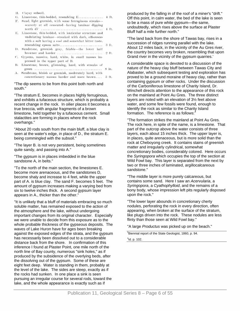
"The dip seems to be from this point both north and south."
"The stratum E. becomes in places highly ferruginous, and exhibits a tufaceous structure, which is probably a recent change in the rock. In oilier places it becomes a true breccia, with angular fragments of a brown limestone, held together by a tufaceous cement. Small stalactites are forming in places where the rock overhangs."
"About 20 rods south from the main bluff, a blue clay is seen at the water's edge, in place of D., the stratum E. being commingled with the subsoil."
"The layer B. is not very persistent, being sometimes quite sandy, and passing into A."
"The gypsum is in places imbedded in the blue sandstone A, in belts."
"To the north of the main section, the limestones E. become more arenaceous, and the sandstones D, become shaly and increase to 4 feet, while the upper part of A. is blue clay. The sand F. becomes 5 feet. The amount of gypsum increases making a varying bed from six to twelve inches thick. A second gypsum layer appears in A., thicker than the other."
"It is unlikely that a bluff of materials embracing so much soluble matter, has remained exposed to the action of the atmosphere and the lake, without undergoing important changes from its original character. Especially we were unable to decide from this exposure as to the whole probable thickness of the gypseous deposits. The waves of Lake Huron have for ages been breaking against the exposed edges of the strata, and the gypsum has necessarily been dissolved out to a considerable distance back from the shore. In confirmation of this inference I found at Plaster Point, one mile north of the north line of Bay county, numerous "sink holes,” as if produced by the subsidence of the overlying beds, after the dissolving out of the gypsum. Some of these are eight feet deep. Water is standing in them, probably at the level of the lake. The sides are steep, exactly as if the rocks had sunken. In one place a sink is seen pursuing an irregular course for several rods, toward the lake, and the whole appearance is exactly such as if
produced by the falling in of the roof of a miner's "drift." Off this point, in calm water, the bed of the lake is seen to be a mass of pure white gypsum—the same, undoubtedly, which rises above the surface at Plaster Bluff half a mile further north."
"The land back from the shore of Tawas bay, rises in a succession of ridges running parallel with the lake. About 12 miles back, in the vicinity of the Au Gres river, the country becomes very broken, resembling that upon Grand river in the vicinity of the gypsum quarries.’
A considerable space is devoted to a discussion of the nature of the heavy clay bluff between Tawas City and Alabaster, which subsequent testing and exploration has proved to be a ground moraine of heavy clay, rather than containing gypsum or other rocks. Under the discussion of the Carboniferous limestone of Charity Island, Dr. Winchell directs attention to the appearance of this rock on the mainland at Point Au Gres. The three distinct layers are noted with an elevation of 3½ feet above water, and some few fossils were found, enough to identify the rock as similar to the Charity Island formation. The reference is as follows:4
"The formation strikes the mainland at Point Au Gres. The rock here, in spite of the name, is a limestone. That part of the outcrop above the water consists of three layers, each about 15 inches thick. The upper layer is, in places, quite arenaceous, but is more solid than the rock at Cheboyong creek. It contains stains of greenish matter and irregularly cylindrical, somewhat concretionary bodies, considerably colored. Here occurs the Syringopora which occupies the top of the section at Wild Fowl bay. This layer is separated from the next by two or three inches of laminated, argillocalcareous sandstone."
"The middle layer is more purely calcareous, but contains some sand. Here I saw an Acervularia, a Syringopora, a Cyathophylloid, and the remains of a bony body, whose impression left pits regularly disposed upon the rock."
"The lower layer abounds in concretionary cherty nodules, perforating the rock in every direction, often appearing, when broken at the surface of the stratum, like plugs driven into the rock. These nodules are less flinty than those seen at Wild Fowl bay."
"A large Productus was picked up on the beach." 3Biennial report of the State Geologist, 1860, p. 94. 4Id. p. 102.
Publication 11, Geological Series 8 – Page 6 of 55
Publication 11, Geological Series 8 – Page 7 of 55
COAL EXPLORATIONS. During the year 1875 reports of coal in the Rifle river region became common and the land about Omer and Deep River received much attention from coal prospectors. Mr. Ira Bennett seems first to have called attention to the shale deposits along the Rifle river, and Mr. E. G. Soverign was one of those very active in the explorations and he organized the Eureka Coal company which did considerable prospecting about Pinnacle Hill and at Deep River. A small quantity of coal was mined on the banks of the Rifle in section 3, T. 19 N., R. 4 E., in May, 1875, and shipped to Smith Brothers of Jackson, Michigan. Mr. George F. Sherwood, superintendent and engineer of the Jackson Gas Works, made a favorable report of the coal for gas manufacture. The main results of the work were a good knowledge of the rock formations reached by the sinking of the shafts and the drilling tests. An extensive description of these operations was given in a work published in 1875 by C. B. Headly and J. G. MacCall of Bay City, parts of which were reproduced in the Bay City Times-Press, July 23, 1898.5
5Annual Report of the Michigan Geological Survey for 1904, page 128.
CARL ROMINGER. The most complete geological examination that has ever been made of Arenac county and vicinity was that conducted by Dr. Carl Rominger, State Geologist, in 1875 and published in Volume III of the State Geological Survey. This report entitled, "Geology of the Lower Peninsula," gives much valuable information concerning the accurate location and character of many outcrops of the region inland, as well as on the shore, and is accompanied by a geological map of the Lower Peninsula.
In discussion of the Eocarboniferous formations, the term "Waverly Group" is nearly synonymous with the Marshall sandstone of the present time, and the Carboniferous limestone of Rominger is the present Grand Rapids series consisting of the Upper Grand Rapids or Maxville, and the Lower Grand Rapids or Michigan series.
In Arenac county the work of Dr. Rominger was prosecuted during the coal excitement on the Rifle river valley, and the records which are given under observations of the "Waverly Group" and the coal measures are of especial value to those interested in coal exploration.6
The best exposure and the only one located in this region of the "Waverly Group,” was found at the West Branch bridge, T. 21 N., R. 3 E., section 16. This outcrop is taken to be similar to the Upper Marshall, or the Napoleon sandstone. The presence of this rock was noted in the salt wells at East Tawas, and as well as the lack of fossils in its upper portion. The fact that the salt brines are derived from the "Waverly Group" is pointed out in contrast to the previous idea of Winchell who
located them in the Michigan Salt Group above the “Waverly."
In the Carboniferous limestone, or the present Michigan Series, mention is made of the outcrops at Island Rapids, Alabaster Point, White Rock Point, Au Gres Point, and others scattered inland on the head branches of the Au Gres river. The superior quality and thickness of the Alabaster gypsum deposits, over those of the Grand Rapids district was recognized. The general location of the outcrops in which the present limestone quarry at Omer is located, was known but not visited.
The Coal Measure beds were examined with especial care, as this was the time of the coal excitement in the Rifle river valley. The operation of the works in the vicinity of Pinnacle hill was considered to reveal only a small amount of the highly bituminous shale rather than the ten-foot vein of cannel coal announced by the prospecting company. The tests at Deep River station were just completed and the shaft was commenced at the time of Dr. Rominger's visit to the locality and was considered the most promising field in the county. Some mention is made of the coal beds penetrated in the various brine wells but the prospects for large coal beds in Arenac county were not considered good, although some of the coal prospectors quoted Dr. Rominger differently. The geological map which accompanied the report outlined quite distinctly the limits of the various formations recognized at that time, and the limitation of the edge of the coal field to the Rifle river has served a useful purpose in discouraging waste of money in exploration for coal north of that river. As an appendix to Volume III is a report by Dr. S. S. Garrigues, State Salt Inspector. This has some reference to salt wells of Bay county, East Tawas and Tawas City. 6Geological Survey of Michigan, Volume III, pp. 141-144; Volume VIII, pp. 4 and 160.
RECENT SURVEYS. During the summer of 1897, F. B. Taylor examined the old lake beaches from Mackinaw to Bay City, and he has written a number of papers bearing on the surface geology of this region. Taylor gave the general location of the Algonquin, Nipissing and Warren beaches of the region.7 His general work upon the moraines has been followed and is given in more detail in other places. The Harrisville-Alcona moraine has been found to extend farther south than his investigations proved. 7A Short History of the Great Lakes; Dryer's Studies in Indiana Geography, Inland Publishing Co., Terre Haute, 1897, pp. 90-110.

ALFRED C. LANE. In the early part of 1897 Dr. A. C. Lane, State Geologist, visited Arenac county for the U. S. Geological Survey in an investigation of the water supply. In reports issued under the title "Water Resources of the Lower Peninsula of Michigan"8 mention is made of the harm of the presence of calcium sulphate in the drinking water, the value of water power on the Au Sable and Rifle rivers, the flowing wells of Au Gres, Turner, Omer and Standish. Maps of the geological formation and the Pleistocene deposits of the Lower Peninsula accompany the report. In the second part of this report a collection of analyses of various waters of the state occur.
Publication 11, Geological Series 8 – Page 8 of 55
8Water Supply Papers No. 30 and 31.
MISCELLANEOUS. The water power of the county lies in the Rifle and Au Gres rivers, both of which have been carefully gage measured and reports9 published since 1902, by the Department of Hydrography of the U. S. Geological Survey under the direction of Robert E. Horton, district hydrographer. A study of the water supply is also included in the studies of the wafer supply of the state by Frank Leverett.10
9Water Supply and Irrigation Papers Nos. 83, 97, 129 and 170. 10Water Supply and Irrigation Papers Nos. 182 and 183.
CHAPTER III. THE CLIMATE.
THE AVAILABLE RECORDS. The only records which are available for use in determining satisfactorily some of the climatic elements are those furnished by the United States cooperative volunteer station at Omer on the Detroit and Mackinac Railroad in the northeastern part of Arenac county. The station was established in 1889 at Omer, which was then the county seat and in the same year changed to Standish where the records were kept during part of 1889, the last half of 1890, a part of 1891 and nearly the entire year of 1892, but no record was complete for one year at Standish. This station was discontinued some time in 1892 and reestablished at Omer early in 1897 where the observations have been continued with some minor irregularities to date. The short time that the Omer records have been kept has led the writer to bring in for comparison the records of a few adjacent stations just outside the county, i. e., East Tawas, Grayling and West Branch.
THE TEMPERATURE. The location of the county along the shore of Saginaw bay gives it the advantage of the lake influence which ameliorates the extremes of temperatures. The bay is practically open throughout the year; only in an exceptional winter is it frozen over. Many traditions are in existence of crossing the bay on solid ice from East Tawas to Sebewaing in Huron county but in 10 years, from 1895 to 1905, the bay has been frozen over only once. The average July temperature of water in the bay several miles out from Point Lookout has been found to be 52° to 54°, while the land temperature during the same month averages 66.9°. This is lower than counties further inland, and the lake evidently acts as a vast cooler to the heated land. During February the water of the small bays along the coast freezes, but it is a rare winter in which the temperature of the water several miles from shore is below 40°, while the land in winter averages nearly 19.8°, thus drawing on some of the heat stored in the lakes during the summer months. The differences in the temperature of the land and water disturb the regular course of the westerly winds and develop the land and lake breezes 1
Fig. 1.—Climatic chart.
The annual average temperature varies from 45.3° to 43° in various parts of the county. At Omer the annual average is 43.1°, while at Standish, eight miles southwest, it is 45.3°.2 The averave for Omer is considered the more reliable as it is computed from the daily observations for the past eight years. The maximum temperature of the year is nearly always reached in July, and the highest maximum ever reached at Omer was 100° in July of 1897, but the average maximum for this month is 97°. "Hot waves” are frequently developed during July, but they are not clearly defined and the high temperatures are moderated by the lake influence. The humidity of the atmosphere makes the higher temperatures more noticeable than in dry counties, but the nights are always cool and the heat of the day never persists long after sunset.

During the winter of 1904, in the middle of February, a cold wave prevailed for a few days over this part of the lake region and the lowest temperature reached since the Omer station was established was recorded on the 17th as 40°, while at East Tawas and West Branch on the 16th it was 20°. and at Roscommon on the 17th -85°. It might be interesting to compare this record with Bela Hubbard's predictions* in 1888 for a cold winter for 1903. In 1889, when the Omer station was first established -33° was reached in February, and on the 1th of February, 1889, during a cold wave which affected a large area of northern Michigan -28° was reported at Omer, -21° at East Tawas, 41° at Grayling and -20° at Alpena. Lake Huron being open and the winds being southerly account for the difference between Alpena and the stations further south on Saginaw Bay, which was frozen. The records of the Omer station show that February is always the coldest month, the average being 14.40° and the lowest minimum temperature of the year is always reached. The records show the meaning of the old weather adage, "When the days begin to lengthen, the cold begins to strengthen."
Publication 11, Geological Series 8 – Page 9 of 55
The greatest ranges of temperature occur in February, September and July, when a change of 50° is not uncommon, and a change of 80° has been observed in February. This range is less than at Grayling and West Branch, which are situated further from the lake and in the midst of a sandy country from which heat radiates more rapidly. The daily temperature changes rapidly with a shifting of the wind, a south lake wind being always warm in winter and cooler in summer, the opposite being true of the winds from the northwest.
A daily change of temperature due to the land and lake breezes is observed in a five to ten-mile wide belt of country along the eastern border of the county. These wind currents depending upon
the unequal temperature of the lake and land are best developed in summer, when the lake breeze is prominent from 9 in the morning to 3 in the afternoon and the land breeze is best developed at midnight to 4 in the morning. The popular phrase that the wind follows the sun is generally true except when the conditions are changed by the presence of a well pronounced cyclonic storm, or thunder storm. The average temperatures for the different seasons are as follows:
1For additional information on the variation of land and water temperatures of Saginaw Bay see the seventh annual report of the Michigan Academy of Science, an article by W. F. Cooper. 2A. Winchell in Tackabury's Atlas of Michigan.
*Memorials of a Half Century, p. 482.
THE FROSTS. The time of the last spring frost is quite important as only after it are the developing crops safe. None but killing frosts are feared; light frosts are of little damage but they retard the proper growth. Garden truck is especially apt to be injured and destroyed. The last spring frost is much later than in the southern counties of the state, and by the middle of May almost all of the destructive frosts have occurred. Occasionally, the crops which have a vigorous start by late June, may be considerably damaged by unexpected frost, as on June 12, 1903. The damage is slight if during the spring there has been considerable rain. The frosts which are most destructive are the occasional ones of July, as in 1898. During the nights of July 10 and 11 of 1898 a temperature of 29° was prevalent over a wide district in the county and was especially destructive, as it came during a time of severe drought. The loss in corn, potatoes, and garden truck was considerable. The average disappearance of the spring frosts for the period in which the records have been maintained is near the middle of May. The experienced farmers of the county find a wide variation in this time due to the distance from the lake, the elevation and the character of the soil.
The fall frosts come late in September when most of the crops are well matured, yet occasionally they occur with great severity at the first of the month and quite often hinder the full growth of the corn. In 1903, on the 28th day of September, the first killing frost was quite general in the county and this is about the usual time of its appearance. Some local observers in the county find that the frost comes earlier on the lowest land and always appears first on the sandy strips before the damp clay land. This may be illustrated by the cooling of the air at night in a hilly country. The air is warmer on the hill tops and cooler in the valleys in which there may be a fog, heavy dew or frost, depending upon the temperature of the air and the clearness of the atmosphere. In several fields of corn near Au Gres village where the frost was heavy in July, 1901, the writer saw a strip of dead corn following the sandy soil, while that on the clay was fresh, green and unharmed. The clay soil with its large content of moisture, loses heat more slowly and in consequence frosts appear there last. The frosts appear a week or two weeks later

in the belt bordering the lake shore than in other parts of the county. The lake exerts a modifying influence because of the greater amount of moisture in the atmosphere and the latent heat of the water.
Following the autumn frosts comes Indian summer which is a period of from two to three weeks of delightful weather, of warm days and clear cool nights. The days are so warm that frequently cherries, strawberries and plums bloom late in October. The air is often filled with a haze which is peculiar at this time of the year, and should not be confused with the heavy smoky atmosphere which occurs during a period of forest fires which often sweep over the sandy plains during the summer months.
The dews are heavy during July and August, especially if the rainfall is deficient and much moisture is supplied in this manner to the growing crops. The dews are heaviest on the lands under cultivation along the lake shore, while on the bare sandy plains northwest of Omer they are very slight, showing possibly some connection between the dews and vegetation, but it is more likely due to the abundant moisture in the air along the lake shore.
Fogs are most numerous in the late fall and early spring. There is usually a fog formed in the late hours of the night along the lake shore and in the river valleys. There is some good in this, because the clouds afford a protection from the frosts.
The atmosphere is remarkably clear. During 1903 at Omer there were 147 clear days, against 23 at East Tawas, 56 at West Branch, and further inland, 85 at Grayling. The twilight arch is wonderfully developed in the east during the nights of clear sunsets. During the summer months when the air is heated over the water's surface, the Charity Islands in Saginaw Bay frequently "loom" so that a superior or inferior mirage is formed, depending upon the air conditions. The "looming" is especially pronounced during a falling barometer and 24 hours in advance of a storm. The dim outlines of the land at Sebewaing across Saginaw Bay have been frequently observed when the conditions were best developed.
THE RAINFALL. The location of the county on the lake gives it a greater rainfall than if its eastern boundary were land because there is more evaporation from the lake surface, hence there is more vapor in the air and a greater chance for rain. The prevailing westerly winds blow to the lake, and if it were not for the land and lake breezes which are well developed over the eastern half of the county, the rainfall would be greatly decreased by the prevailing winds. By comparison of precipitation of places on the western and eastern side of Lake Michigan, the greater rainfall is found where the prevailing wind is from the lake to the land, and the same conditions undoubtedly prevail on the shores of Lake Huron, but records are not sufficiently long for comparison.
The average annual precipitation of 25.71 inches is 5.13 inches less than the average of 30.84 inches for the entire state. It emphasizes the presence of a region northwest of Saginaw Bay which is deficient in rainfall. The general records show that the regions of the state bordering Lake Huron have a less annual rainfall than the general average for the state. This departure in rainfall of the region adjacent to Lake Huron is believed to be due to the direction of the prevailing winds and it is also noted that when the precipitation for a particular year varies from the normal, the winds for that year have departed from the average direction.
The greatest rainfall comes at the time of the greatest growth of vegetation and keeps the soil in good condition for crops. See Fig. 1. The least precipitation comes during January and February. The greatest variation is in the month of August, which is possibly due to the supply being largely derived from the thunderstorms.
The average snowfall is nearly 40 inches annually. For 1904 and 1905 it was 33 inches and 41.5 inches respectively. In the latter part of March and early April, the streams and creeks of the county overflow their banks and in some years do considerable damage. In some springs the rapid melting of the winter's snowfall, augmented by the spring rains on the frozen ground cause the unusual floods.
THE WINDS. The regular sweep of the westerly winds in this latitude is disturbed by the lake influence, and it is difficult to estimate what the direction will be for a season or a year. Some evidence of the westerly wind drift may be seen in the branches of the wind swept pines along the banks of the Rifle river at Pinnacle hill and near the now abandoned village of Moffatt.
The winds coming from the northeast have abundant chance to gather strength in their long sweep along Lake Huron, and form the heavier storms of the year. With
Publication 11, Geological Series 8 – Page 10 of 55
Publication 11, Geological Series 8 – Page 11 of 55
the northwest winds comes the coldest weather; with the southerly winds the warmer weather. The records show the prevailing winds to be from the southwest but their strength and regularity is very uncertain. In the days of sailing vessels, because of the changing storms on Saginaw Bay, it was greatly feared in a lake voyage and many small barks foundered in the waters of the "Sailors’ Graveyard." Only a few destructive windstorms have occurred within recent time, but in the days of standing timber in the county there were several large areas of "windfalls” which had been caused by violent storms. On April 24, in the spring of 1897, a heavy windstorm resembling a tornado occurred at Omer, damaging about $4,800 worth of property, and injuring three people. The path was about 40 feet wide and half a mile long. Mr. C. F. Schneider, section director of the Michigan Climate and Crop Service, makes the following report upon the meteorological conditions on the day of the tornado:
"The morning at Omer was clear and warm, with a fresh southwest wind. Towards noon the sky began to cloud over rapidly and the wind to increase in force. During the afternoon the clouds lowered and began to assume a threatening appearance, and the southeast wind increased to a gale of about 30 miles per hour. By 5 P. M. the sky was very dark and the wind had become strong enough to loosen signs and boards, and it had begun to shift to the south-southeast. At this time a violent thunder-storm set in, the thunder and lightning being continuous. The thunder-storm moved from the southwest to the northeast, and in advance of the tornado. About 5.15 P. M. a light sprinkle of rain fell for a few minutes, and this was followed by a light fall of small opaque hailstones. During the half hour from 5 P. M. to 5.30 P. M. the wind continued to blow a gale from the south-southeast and this wind was very warm and somewhat suffocating. At 5.30 P. M. (as near as can be determined), the tornado cloud suddenly made its appearance from the southwest.
This tornado cloud was typical in form, being described by such citizens as saw it as "balloon shaped,” or as text-books speak or such phenomenon, "funnel shaped." It was about 40 feet high, its top having a steady forward movement, but the lower part of it, which corresponds to the basket or car of the balloon, had an unsteady motion, moving from side to side, and in advance, and sometimes in the rear, of the body of the cloud. The whole cloud had a wavy horizontal movement, sometimes being nearly in contact with the earth, and then lifting up for some distance. It was accompanied by a peculiar roar."
The most common storms are the local thunder-storms, developing on the high sand plains and moving eastward to the lake with considerable velocity and abundant rainfall. These storms are most plentiful in August, and the rounded nimbus clouds with the accompanying rain curtain may be seen in the east from the sand plains about Pinnacle hill and Alger on any afternoon of the month.
During January and February a thunder-storm may develop over Saginaw bay and move inland from the northeast. Such winter storms occur each season, but they are few in number.
The winds have an important place in the lives of the shore people, especially the fisherman, small trading boats and those engaged in rafting timber, which is now but a small industry compared with former years. The water in the shoal bays is often changed four feet or more in a few hours by a strong wind. At Bay City, June 20, 1902, a strong southwest wind drove the water out of Saginaw bay and surrounding flats, leaving many boats stranded, and doing much damage to fishing nets. The water level of Tawas bay has changed from 580' A. T. to 578.30' A. T. in five hours during a southeast wind, and in this bay a southwest wind always raises the water level, while a northeast wind lowers it. In producing these changes of level, the wind will produce strong currents. Capt. Small of the United States life saving station at Ottawa Point is the authority for the statement that a southwest wind produces a strong littoral current to the northeast along the coast of Arenac and Iosco counties. A northwest wind produces a current in the opposite direction, much stronger in proportion to the wind. The wreckage from the steamer Baltimore, which sank May 24, 1901, 2.81 miles south by east ½ east from Point Au Sable, was carried southwest by the currents produced by a northeast gale, after the wind had changed directions. These shores directly exposed to the northeast littoral currents, and not protected by points or shoals, are being eroded quite rapidly, in fact north of all the larger points the banks are often 10 to 15 feet in height. The shoal places south of Au Gres, Ottawa Point and Gravelly Point are being filled with sand. When the wind is from the northeast, the currents bring in cold water from the lake which is lower in temperature than the water under the lee of the many small projecting promontories. The drift wood and the littoral material of all kinds which is in transit along the shore would seem to verify the average course of currents as heading to the southwest.
CHAPTER IV. THE GEOLOGICAL COLUMN.
INTRODUCTION. It is of practical value to know the kind and character of rocks that would be passed in making a drilling or shaft at any point within the county. The geological column (Fig. 2) has been constructed for the purpose of showing what layers of rock are below the surface, their order, thickness, and general relationship. The information for this column is derived from a well drilled at Standish for James Norn and from many other wells in the county. The records from Grayling, Bay City and Midland have been used for comparison and correlation. As to where in the column a drilling will begin information can be gained from Fig. 2.

FIGURE 2.
THE PLEISTOCENE. This includes the soil, glacial drift and all the material which has been recently formed or is in the process of deposition. The soil map of Arenac county shows that its surface is roughly of three kinds; "the plains", the rolling clay uplands and the strips of flat "prairie" land along the shore of Lake Huron. These areas differ in their soils, topography, and plant growth. The ice sheet was directly or indirectly the chief factor in shaping all of the surface features of the different areas. The evidence is abundant that such a great sheet of ice once covered this entire region. The character of the soil is one of the simplest ways by means of which the former extent and general character of the ice sheet can be shown. Soil is formed by rock decay and unless it is removed it lies
near the rock-ledge from which it was formed. Such soil is called "residual", but the soil and boulders on the surface in this county are entirely different and could not have been formed from the underlying sandstones, shales and gypsum, hence this foreign soil has been transported to this region. The great ice sheet passing southward from the northeastern shore of Lake Huron brought large granite boulders, greenstones, and various of the "hard" rocks which are entirely different from the bedrock of this county. The fine soil is largely the pulverized rock material which has been formed by the Ice sheet and transported to this county. The glacial drift, consisting of the soil and other materials which are the result of glacial action, forms a veneer of varying thickness over most of the bedrock of the county.
It is of slight depth along the eastern part bordering on Lake Huron, while its greatest thickness is to the northwest about Alger and Maple Ridge. The many rock outcrops on the Lake Huron shore from Alabaster to Au Gres, have only a slight veneer of the drift, and the general smoothness of the rock surface is the result of ice action. At the Griffin stone quarry north of Omer, some fine glacial striations were uncovered by the workmen in stripping the rock and Plate III A shows the small ridges with the “knob and trail” effect. East of the Griffin quarry is the same limestone formation on the property of Mr. Thomas Burt, some of the ledges which face the northeast appearing to be crushed, and in many places the blocks have been “plucked.” The well records indicate that the drift is 30 to 40 feet in thickness at Saganing, and north-east at King’s Corners is a dug well 30 feet deep through a brown clay without pebbles to a white sandrock at the bottom. The drift at Standish is 60 to 80 feet thick, and the well drillers find that it contains many hard boulders. At Omer it is 30 feet to the Coal Measure sandstone which is exposed in the bed of the Rifle river. In Au Gres village the well records differ; in some of the dug wells the rock is covered with 30 to 40 feet of clay with many boulders of gypsum and limestone. None of the wells at Point Lookout pass through the drift, the deepest well being 90 feet which is said to be entirely in sand and gravel.
Fig. 3.—Geological section from East Tawas to Standish.
In the western part of the county southeast of Sterling it is 75 feet to sandstone and shale, while to the north there are several dug wells through drift 75 to 80 feet
Publication 11, Geological Series 8 – Page 12 of 55

thick in Adams township, west of Sterling. In Moffatt township north of Alger at Dunn's deep well it is 800 feet to rock and the greater part of the drift there is a stiff brown clay with a few boulders. At Martin's Corners in Clayton township, James Thompson's well is 164 feet deep and does not reach the rock; southeast Peter Gilbert has a dug-well of 60 feet which has fine white sandstone at the bottom. It is doubtful if this is through the drift for the sandstone here may be similar to the "crag" found in the cuts in many of the near-by ravines. The percolating waters carry enough lime corbonate to firmly cement the sandy layers and form a "glacial crag" of several feet in thickness. Sandstone of a darker color and coarser grain appears in the bottom of the Rifle river a short distance south of the Gilbert well and at an elevation 50 feet lower. The wells at Maple Ridge are all less than 60 feet deep and none reach rock. The drift here is clay, covered with coarse gravel and sand.
The valley of the Rifle river is deep and narrow being incised in the glacial deposits which are well exposed along its banks. The drift is somewhat over 100 feet in thickness at Pinnacle hill. The Michigan Series outcrops in a few places along the banks and are present in the river bed for nearly a mile. The covering of the rock is a tough gray clay of 18 to 25 feet in thickness and with but few pebbles present. Above the clay comes 30 to 40 feet of a gravelly sand, on top of which is 10 to 15 feet of fine sand. The sand is frequently duned to considerable height and Pinnacle hill is one of the highest of these dunes along the Rifle river. In places where the moraines cross the river there are "riffles" formed by the boulders which have been left by the removal of the clay.
The thick coating of glacial drift is of much benefit in that it produces a fertile soil when it consists largely of clay, but when it is mostly sand it forms the "jack pine plains" which are practically worthless for farming.
THE GENERAL FEATURES OF THE BEDROCK.
The bedrock of this county is composed of the softer sedimentary rocks which occur in almost horizontal layers. None of the "harder" rocks, nor those bearing ore of any kind occur within the county. The copper nuggets which have been frequently found have been transported here along with the other glacial drift. Small bunds of iron ore occasionally occur in the sandstone and in the Coal series iron pyrite is frequent but in small quantities.
Fig. 4.—Geological section from Culver to Lake Huron.
The great beds of sedimentary rocks which outcrop in this region are a part of the Palaeozoic system which includes all of the principal deposits of limestone, sandstone and coal series of the northern and central part of the United States. Arenac county stands on the northern edge of the great saucer-like arrangement of rocks which occupies the central part of the Lower Peninsula of Michigan. The same series of rocks are exposed here that are found to the southeast in Huron county and to the southwest in Kent county.
The formations represented by outcrops in the county are the northern edge of the Saginaw Coal Series, the Upper Grand Rapids or the Maxville limestone, and the Lower Grand Rapids. Dividing the county roughly the base of the Coal Series is practically the course of the Rifle river and a line from the mouth of the Au Gres river passing northwest about two miles south of Twining would be near the base of the Maxville limestone, while the remaining northern part of the county is underlain by the Lower Grand Rapids. The general arrangement of these various formations is shown in the diagrams (Figs. 3 and 4) while the details of the outcrops are discussed on the following pages under the various appropriate headings.
THE SAGINAW COAL SERIES. This county is located on the northern edge of the Saginaw Coal Series and is represented by sandstones, shales, and the Carboniferous shales. Along the Bay-Arenac county line these series have a thickness of about 70 feet and to the north they become less and the base of the series is approximately the course of the Rifle river. Outcrops of a Carboniferous shale and sandstone are very numerous along the Rifle and all of the well records south of the river show that the base of the formation is never more than 130 feet from the surface and it lies directly under the heavy covering of drift.
THE PARMA SANDSTONE. This sandstone has not been clearly identified in this county, unless the white sandstone in the bed of the Rifle river at Omer could be the thin edge of this formation. It is a fine, white, cross-bedded sandstone full of ripple marks and containing many fragments of Carboniferous plants. This is a firmer and whiter sandstone than that of the Saginaw Series which occurs in the creeks about Deep River and contains many small nodules of iron pyrites.
Publication 11, Geological Series 8 – Page 13 of 55

Publication 11, Geological Series 8 – Page 14 of 55
THE UPPER GRAND RAPIDS OR BAYPORT. This formation consists of gray and brown limestone (dolomites) and beds of brown sandstones. In these formations in Huron county,1 the dolomites are distinctly green and the sandstones lighter in color.
The limestones and sandstones are well represented by outcrops at Griffin Quarry, Point Au Gres, Burt's Quarry and on the Tyler property. From the various well records the thickness is nearly 70 feet. 1Geological Survey of Michigan, Volume VII, Part 2, Report on Huron county.
THE LOWER GRAND RAPIDS. This is the series which has the various layers of gypsum, blue arenaceous shales, dolomite and limestone. This formation along the Bay-Arenac line is about 100 feet deep and while the records of Standish show gypsum, all of the other deep wells in the county pass through layers of various thickness, and in general the two gypsum beds are about 30 feet apart in the southern part of the county, while northward the distance is much more, nearly 60 to 75 feet.
LOWER STRATA. Below the Grand Rapids are other strata exposed only in the deeper borings like that at Standish. The Marshall is a thick formation largely of sandstones and generally yielding fresh water. This is underlain with a great formation of blue shales, etc., in which occur some brine bearing sandstone. Beneath is the black Sunbury or Berea shale, then the Berea sandstone and the Devonian black shales. The Standish well shows what may be obtained by boring in this country. For information regarding the strata of greater depth, the well records of Grayling, Bay City, East Tawas and Alpena should be consulted.2
2Michigan Geological Survey, Volume V, Annual reports of the Michigan Geological Survey for 1901, 1905, and 1908.
CHAPTER V. PALAEOZOIC OR BED ROCK
GEOLOGY.
THE SAGINAW COAL SERIES. Distribution. The edge of the Saginaw Coal Series which outcrops in various places along the Rifle river first directed attention to the coal series in Saginaw valley and many early attempts were made to mine the formation in the Rifle river valley but the results have been always meager and unsatisfactory. The strong ridge of Maxville limestone, extending northwest through, the county from Point Au Gres to various outcrops on the Rifle river in Section 7, T 20 N., R 7 E., is the northern limit of the coal formations and outcrops.
Tests to the south of this ridge between Omer and Alger show that the coal formations are thin, irregular, and generally without suitable roof, which is necessary in mining.
Outcrops. In the Rifle river bed at Omer the edge of the Saginaw Coal Series appears as a gray sandstone, very friable, with distinct cross-bedding lines and many broken fragments of the Carboniferous plants which are occasionally in good preservation. This sandstone is yellowish in places, where the water from the soil above has leached the iron into the sandstone, and the plant remains are often in irregular layers in small pockets, as if the material had accumulated in pools of stagnant water. This sandstone extends from the mill dam at Omer for some distance down the Rifle into section 23, and was readily traced in the small creek in section 22, to the southwest corner of the section. From the Huckle bridge, in section 23, the sandstone appears in various places in the bed of the Rifle river, in the N. W. ¼ of section 25, and the southern part of section 30, but these outcrops are not easily found, and are seen only during times of extremely low water. Mr. M. J. Griffin, a railroad contractor who installed the Detroit and Mackinac railroad bridge at Omer, is authority for the statement that a pocket of bituminous shale two feet thick was found on top of the sandstone and the shale fired the dummy hoisting engine for several days. The presence of shale in pockets of this kind is not uncommon, and frequently happens along the river at this place. Mr. O. B. Sanderson has reported some three feet of shale in a well on the west side of the river in the village, and Mr. W. E. Clouston found many small seams of black shale in a shallow well just west of the mill-dam. The formation of shale and sandstone is not thought to be more than 25 to 30 feet thick at Omer, although this varies and the reliable records are meager.
The Rifle river bed in section 2, T. 19 N., R. 4 E. contains some of the same sandstone as found at Omer. This was exposed for some 200 feet on both sides of the bridge, and in no place over 6 inches above the low water of August in 1900. The sandstone was coarse grained,—some small, pebbles, many pieces of broken plants (Calamites), and in many places discolored yellow by iron carbonates. Some parts of the outcrops were very hard and thin-bedded, showing the same undulating character common in the shore line deposits as at Omer. The river has worn away "pot" holes in the formation, and large angular blocks are scattered along the river bed with some glacial boulders, "greenstones", 6 to 10 feet in length. The black shale which is present here in small seams, averaging one-half inch, is irregular, the layers being welded together and not continuous.
On the property of Mr. Stevens, shale and sandstone beds line the bank of the Rifle and form its beds in section 8, T. 19 N., R. 5 E., for several hundred feet. Fourteen feet of shale and sandstone overlain by fire clay was found by digging in the river bottom at this place and several small horizontal shafts were drifted into the bank by various prospectors. From the results

obtained from several preliminary drill tests, Mr. Stevens sunk a test shaft on the south bank of the river in section 8 and found the following strata:
12 feet clay. 12 “ shale.
6 “ fire clay. 5 “ hard blue shale. 1 “ coal (cannel). 1 “ fire clay.
10 “ soft shale. 1 “ coal.
The lower coal is black and is an excellent quality steam coal. The first seam was drifted in south some 50 feet, and gradually thinned out, and the fire clay thickened.1 The coal of the upper seam is hardly a cannel coal as it does not burn readily only in some carefully selected samples, and is rather high in sulphur and calcium sulphate. The foot of the coal Is made up of many small seams and dips to the lower bed which appears horizontal; if the two seams joined, a fair amount of coal might result. Mr. E. G. Soyerign, a coal prospector of Bay City, had the water pumped from the shaft in the spring of 1900 and the beds were examined by an expert. The report was favorable for the first seam while the second was not examined. Mr. Stevens, the owner, drilled in the bottom of this shaft some 112 feet, passed quite quickly the shales and stopped, in the hard shale, and a bitter water was found in the bottom of the hole. (Undoubtedly drilled some distance into the limestone or Upper Maxville). A second drill hole of 100 feet was made 25 rods south of this shaft and no coal was reported, but a large amount of very hard rock was found.
Following the Rifle up stream from the point where the tests were made by Mr. Stevens, frequent "riffles" occur in the river bed over the sandstones which are poorly exposed until the Pinnacle hill region is reached in sections 2 and 3, T. 19 N., R. 4 E. The operations about Pinnacle hill have been numerous, and it was here that the first coal exploitation occurred in the Saginaw valley. The following account is based upon careful investigation of the outcrops, clippings from old newspaper reports, and statements from the different owners and those who have worked in the shafts. The only trace at present of the former prospecting is in the several large piles of sandstone and bituminous shale which mark the dumping ground of the different shafts.
Publication 11, Geological Series 8 – Page 15 of 55
1Michigan Geological Survey, Volume VIII, Part 2, Analyses.
Early Operations Along the Rifle River. Mr. Ira Bennett first called attention to the presence of coal along the Rifle in 1875, and did some prospecting with results sufficient to locate several claims. He sold his interests to the Eureka Coal company, an organization of prominent Bay City men, who did considerable prospecting under the direction of Mr. E. G. Soverign. 'The Saginaw Courier Herald for June 23, 1898 under
title of "Records of the Past," makes the following statement regarding Rifle river coal:
"Early in the winter of 1875 the startling announcement was made that in that portion of the Saginaw valley known as the Rifle river region, coal had been discovered. The report, although at first discredited, notwithstanding that the region was within the boundaries of the state in which coal measures were laid down, was early in May confirmed by the sinking of a shaft by the Eureka Coal company upon their lands in section 3, T. 19 N., R. 3 E. This shaft being upon the river Gats, required but 17 feet excavation to develop a vein of cannel variety of over 8 feet in thickness. The distance of the shaft from any line of conveyance forbade the endeavor to utilize the discovery, and since the development of the fact that coal existed in large veins, nothing more has been done towards bringing it into use."
The Eureka Coal company made several tests in sections 2 and 3 near Pinnacle hill along Rifle river, with the following results, as quoted from the Bay City Tribune for the year 1875.
"The first hole bored was to a depth of 120 feet, and while a vein of only 6 inches in depth was struck, the miners discovered vast quantities of slate and fire clay, which by many is supposed to be as great a source of wealth as the coal. We subjoin a statement of the thicknesses of the different veins:
After shifting from the first hole a vein of coal was struck only 11 feet below the surface. Continuing the boring the vein was found to be 2½ feet in thickness, below it, 5 feet of slate /was found, and, under this, another vein of coal (?) 5 feet in thickness. April 13, 1875, a telegram from E. G. Soverign from Sterling stated that they had struck a vein of 6 feet in thickness. This is the fourth hole bored. In the first hole, 6 inches of coal was struck, in the second, 18 inches, in the third hole, 5 feet, and 2½ feet being found in the last 6 feet. The latter vein is 19 feet below the surface, there being above the coal 18 feet of clay and 9 feet of slate."
Publication 11, Geological Series 8 – Page 16 of 55
It was at this site in section 2, T. 19 N., R. 4 E. where the 6 foot bed of coal had been reported and that a shaft (No. 1) was sunk by the Eureka Coal company. In this shaft, according to reports, black shale and coal occurred at 18 feet. This is apt to be correct as far as the shales are concerned, for the shaft was located in the northwest quarter of section 2, on a clay terrace 15 feet above the river bed in which there is at this point an outcrop of bituminous shale. The entire depth of this shaft was 27 to 29 feet. The upper 15 feet was a loose drift, then three feet of hard calcareous clay, then three feet of hard black shale, and seven feet of "cannel coal,” which of course is incorrect, as shown by the way the coal burns, and at the bottom some four feet of coal. It is well to remember when interpreting these records the frequent mistake of prospectors in calling black shale, coal. At 28 to 30 feet this shaft was drifted south 20 rods where a good roof was found and a large quantity of hard, black shale removed. Borings have been made on the north side of the river opposite shaft No. 1, which, gave 25 feet of drift and 20 feet of sandstone, with no sign of coal. Mr. Ortman, of East Saginaw, made a test on the north side of this same location and found 21 feet of drift, then sandrock, blue shale and black shale to 190 feet, but no signs of coal.2 In the southwest corner of section 2, T. 19 N., R. 4 E., which is three-fourths of a mile southwest of Bennett's shaft (No. 1), a test was made. Rocks, sand and shale were found under 60 feet of drift material at 100 feet, and no positive signs of coal. Mr. James Ramsdell, of Bay City, tested in section 10, T. 19 N., R. 4 E, and found:
75 feet sand. 25 “ clay.
7 “ sand rock. and from this point to 200 feet, shales, fire clay, and last the underlying limestone. It may be that the shales found will prove small beds of coal, but no extensive beds are shown by the actual tests.
The following letter from Edward Hill to William Barrie, Jr., gives some of the facts regarding the first work at Pinnacle hill:
"Dear Sir:—The history of the early discovery of coal on the Rifle river published in the Courier-Herald, June 23, 1898, under the heading "Records of the Past" recalls many incidents attending this important discovery. My attention has been directed to an error of description occurring in the extract from the actual report of the "Manufacturers of the Saginaw Valley, 1875," which it may be well to correct.
In the report, the range is inaccurately stated as 3 east. Following the first excitement of the discovery of coal in undoubted quantities in Bay county, now Arenac county, in May, 1875, the Eureka Coal Company was organized and sunk a shaft on the banks of the Rifle river in section 3, T. 19 N., R. 4 E. A heavy vein of coal was struck 17 feet below the surface, corroborating the report of the State Geologist, Dr. Rominger, who said 'this is the most important vein of coal recently found, being of the quality
it is, and also being necessarily of so extensive a mine. There is an abundance of coal extending southwestward and westward 50 miles.’
An experienced mine operator opened up and developed some 200,000 tons of a superior quality of cannel coal, carloads of which were shipped to Jackson and other parts of the state, for testing and experiment. When thoroughly tested the results were most satisfactory, as evidenced by the following extract from a letter from Smith Brothers, Jackson, Michigan, under date of February 5, 1879:
'We have disposed of the coal from your Rifle river mine and it has given first rate satisfaction. We are having inquiries for it every day. Our trade calls for about 500 tons, if you can supply us, please answer.’
A most favorable report3 of the coal for gas manufacture was given by Geo. F. Sherwood, superintendent and engineer of the Jackson Gas Works as follows, viz.:
Charge of coal, 4,800 pounds. Gas made, 15,600 cubic feet. Yield per pound, 3.25. Burns freely with no clinkers, and makes a very hot fire.
The Eureka Coal Company, comprised of well known business men of Bay City, was capitalized for $250,500. Many shares of the stock were disposed of, one block of $50,000 going to New York City.
The management of the Michigan Central Railroad discredited the extent and value of the coal deposits and refused to co-operate with the Eureka Coal company, who, in view of this discouragement and the pressure of other established interests, cancelled their stock and abandoned the enterprise, the magnitude of which can only be conjectured, had it been vigorously prosecuted during the interval of 20 years. During the period of active operations at the mine, owners of land in the township made many tests, finding veins of coal from 2 to 8 feet thick,4 in every section examined.
I am, Very truly yours, (Signed) EDWARD HILL."
In 1878 to 1879, the first shaft was repaired and a shaft was sunk on a high terrace south of the Rifle river in section 3, 60 to 70 feet deep, some 30 rods south of the original one. The intention was to use shaft No. 2 for hoisting and the original shaft No. 1 for pumping water. In shaft No. 2, clay and sand were found, but no rock, the difference between the elevations of the two shafts being at least 40 feet. Mr. Simmons, who was employed in making the "road" between the shafts, found the coal rapidly thinning out from four feet in the shaft No. 1 to four inches, some 200 feet off the road. Some 500 tons were taken out at this time. The best coal was claimed to have been found near the bottom of the shaft. Parts of it had the characters of a good cannel coal, but from some tests in the engines of the Michigan Central it was reported to have much clinker and smoke, although it appeared to possess good heating properties. The coal

Publication 11, Geological Series 8 – Page 17 of 55
was bright, shining, breaking easily into irregular blocks, and containing many seams of pyrite in both forms. Some good fossil rushes and perfect pieces of resin (pollen duct) were found. A drift was made under the river north from shaft No. 1, and the beds were found to thin out. The shafts were abandoned until 1899, when Mr. E. G. Soverign pumped out the water from shaft No. 1 and made a drill test in the bottom of the shaft, and since that time the property has been idle.
In the vicinity of Deep River station, on the Michigan Central Railroad, a newspaper5 gives the following account of the sinking of a shaft and other operations in the following extracts:
"For several months, however, test had been made of the land adjacent to the railroad at Deep River and the neighborhood, which has fully established the fact that over a territory comprising at least 50 square miles, a similar vein of coal exists. Early in January of this year, Messrs. Stevens and Graham commenced the sinking of a shaft near their mill at Deep River on the line of the Jackson, Lansing and Saginaw Railroad, and at this writing are progressing favorably towards a vein, shown by the preliminary borings to be nearly 8 feet in thickness. This shaft passes through about 28 feet of surface clay, striking the Woodville sandstone, from the surface of which the coal vein is about 80 feet. The shaft now being sunk is 12 feet in size, and will probably be connected by the middle of March, when the quality of the coal at this point will at once be manifested."
The above Deep River shaft, sunk by Stevens and Graham early in 1875 to 106 feet in depth, passed the following strata:
20 feet drift. 10 “ clay. 53 “ sandstone. 20 “ shale.
1 “ coal. 2 “ shale.
106 “ In this shaft, an attempt was made to drift in and this was carried out for some 40 feet, but the abundance of water which flowed into the shaft from the top of the sandstone is said to have made the project a failure. The wells one mile east of Deep River station reach the sandstone at 10 to 20 feet, at the schoolhouse in section 33 it is 8 feet to sandstone. At the center of section 26, the sandstone is 16 feet from the surface and at the southwest corner of this section the same formation is 8 feet from the surface. A friable white sandstone, mottled with yellow spots of iron carbonate, is in the bed of the creek for over one-eighth of a mile, where it passes through section 33, T. 19 N., R. 4 E. The sandstone contains many fragments of plant remains. The dip is very irregular, owing to the discordant character of the sandstone. On the western edge of the outcrop it was 36° to the south and on parts of the eastern edges directly opposite. Small patches of sandstone
occasionally occur along the creek for several miles down stream, showing that this formation is the first readied by the wells in this region. The rock is closely similar to the formation in the bed of the creek at Onier, and it is believed that the two sandstones are very near together in the same horizon of the coal series. To the northwest of Deep River station, in section 29, sandstone is reached at 75 feet in a well on the property of Mr. G. H. Rabbit, and in a test hole near the center of this section a small vein of black shale was reached at 1TO to 175 feet. At Sterling it is 85 feet on the average to rock through the clay. At Culver, on the Michigan Central Railroad, Mr. John Dunn tried to secure a good supply of water for a mill and the stock, by deep drilling, but was unsuccessful. It was 300 feet to the dark bluish shale, and going 200 feet in the shale gave no water. This indicates clearly that the edge of the coal series passes some distance to the south of Culver, and some of the outcrops on the Rifle in the region of T. 20 N., R. 4 E., section 7, may be correlated with Dunn's well to define the limits of the northern edge of the coal basin. 2Geological Survey of Michigan, Volume III, p. 142. 3Saginaw Evening News, July 23, 1898. 4Reports of coal over 5 feet thick have usually proved fallacious in Michigan. Only experienced men are sure not to include some black shale in the coal. Lane. 5Saginaw-Courier-Herald, July 23, 1898. In an article by C. H. Headley and J. C. McCall, entitled "Records of the Past."
MAXVILLE OR BAYPORT LIMESTONE (UPPER GRAND RAPIDS).
Distribution. The Upper Grand Rapids or Maxville limestone is a formation largely of limestone with some hard sandstones, which was deposited on the Lower Grand Rapids. The limestones are somewhat cherty, thin bedded and full of fossils, the corals being well represented. The sandstones are gray or white in color and often strongly ripple marked, indicating the nearness of the shore at the time of their deposition. The limestone beds often have small druse cavities containing fine crystals of calcite. The thickness of the formation at Omer is believed to be near 45 feet. This series of sandstone and limestone marks a period during which freshening of the great inland sea occurred and the formation of a great body of fresher water having a connection with the Palaeozoic ocean, in which at this time similar littoral formations were being deposited in Ohio, as the Maxville limestone, and, in the Mississippi valley, as the St. Louis limestone. The change from the salt depositing water of the Lower Grand Rapids, to the open sea as shown by the character of the Upper Grand Rapids is one due not to climatic changes, as shown by A. C. Lane,6 but rather to the depression of the strata which allowed the ocean to enter greatly freshen this inland salt sea. The climate was unchanging throughout this time and remained as arid as it was when the gypsum had been formed. The Maxville is the only formation outcropping in the county which contains fossils, the greater number being In the upper beds and
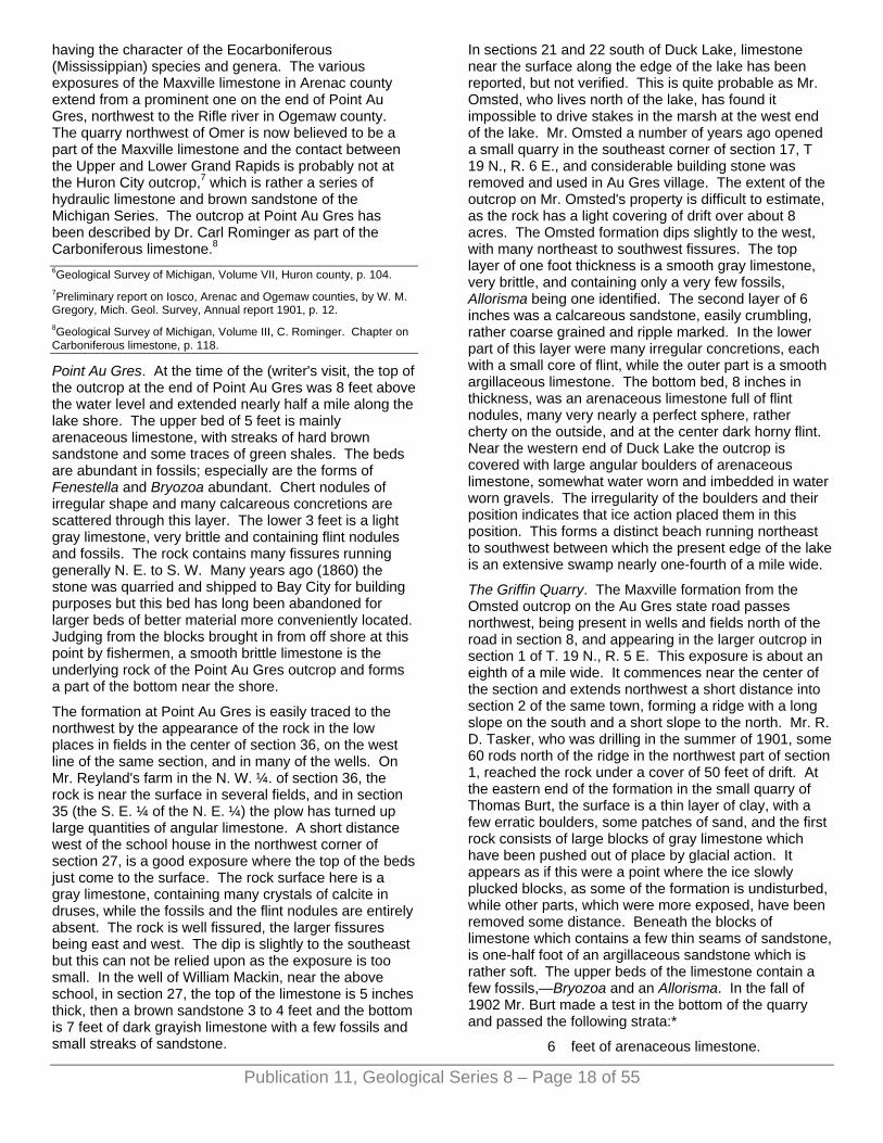
Publication 11, Geological Series 8 – Page 18 of 55
having the character of the Eocarboniferous (Mississippian) species and genera. The various exposures of the Maxville limestone in Arenac county extend from a prominent one on the end of Point Au Gres, northwest to the Rifle river in Ogemaw county. The quarry northwest of Omer is now believed to be a part of the Maxville limestone and the contact between the Upper and Lower Grand Rapids is probably not at the Huron City outcrop,7 which is rather a series of hydraulic limestone and brown sandstone of the Michigan Series. The outcrop at Point Au Gres has been described by Dr. Carl Rominger as part of the Carboniferous limestone.8
6Geological Survey of Michigan, Volume VII, Huron county, p. 104. 7Preliminary report on Iosco, Arenac and Ogemaw counties, by W. M. Gregory, Mich. Geol. Survey, Annual report 1901, p. 12. 8Geological Survey of Michigan, Volume III, C. Rominger. Chapter on Carboniferous limestone, p. 118.
Point Au Gres. At the time of the (writer's visit, the top of the outcrop at the end of Point Au Gres was 8 feet above the water level and extended nearly half a mile along the lake shore. The upper bed of 5 feet is mainly arenaceous limestone, with streaks of hard brown sandstone and some traces of green shales. The beds are abundant in fossils; especially are the forms of Fenestella and Bryozoa abundant. Chert nodules of irregular shape and many calcareous concretions are scattered through this layer. The lower 3 feet is a light gray limestone, very brittle and containing flint nodules and fossils. The rock contains many fissures running generally N. E. to S. W. Many years ago (1860) the stone was quarried and shipped to Bay City for building purposes but this bed has long been abandoned for larger beds of better material more conveniently located. Judging from the blocks brought in from off shore at this point by fishermen, a smooth brittle limestone is the underlying rock of the Point Au Gres outcrop and forms a part of the bottom near the shore.
The formation at Point Au Gres is easily traced to the northwest by the appearance of the rock in the low places in fields in the center of section 36, on the west line of the same section, and in many of the wells. On Mr. Reyland's farm in the N. W. ¼. of section 36, the rock is near the surface in several fields, and in section 35 (the S. E. ¼ of the N. E. ¼) the plow has turned up large quantities of angular limestone. A short distance west of the school house in the northwest corner of section 27, is a good exposure where the top of the beds just come to the surface. The rock surface here is a gray limestone, containing many crystals of calcite in druses, while the fossils and the flint nodules are entirely absent. The rock is well fissured, the larger fissures being east and west. The dip is slightly to the southeast but this can not be relied upon as the exposure is too small. In the well of William Mackin, near the above school, in section 27, the top of the limestone is 5 inches thick, then a brown sandstone 3 to 4 feet and the bottom is 7 feet of dark grayish limestone with a few fossils and small streaks of sandstone.
In sections 21 and 22 south of Duck Lake, limestone near the surface along the edge of the lake has been reported, but not verified. This is quite probable as Mr. Omsted, who lives north of the lake, has found it impossible to drive stakes in the marsh at the west end of the lake. Mr. Omsted a number of years ago opened a small quarry in the southeast corner of section 17, T 19 N., R. 6 E., and considerable building stone was removed and used in Au Gres village. The extent of the outcrop on Mr. Omsted's property is difficult to estimate, as the rock has a light covering of drift over about 8 acres. The Omsted formation dips slightly to the west, with many northeast to southwest fissures. The top layer of one foot thickness is a smooth gray limestone, very brittle, and containing only a very few fossils, Allorisma being one identified. The second layer of 6 inches was a calcareous sandstone, easily crumbling, rather coarse grained and ripple marked. In the lower part of this layer were many irregular concretions, each with a small core of flint, while the outer part is a smooth argillaceous limestone. The bottom bed, 8 inches in thickness, was an arenaceous limestone full of flint nodules, many very nearly a perfect sphere, rather cherty on the outside, and at the center dark horny flint. Near the western end of Duck Lake the outcrop is covered with large angular boulders of arenaceous limestone, somewhat water worn and imbedded in water worn gravels. The irregularity of the boulders and their position indicates that ice action placed them in this position. This forms a distinct beach running northeast to southwest between which the present edge of the lake is an extensive swamp nearly one-fourth of a mile wide.
The Griffin Quarry. The Maxville formation from the Omsted outcrop on the Au Gres state road passes northwest, being present in wells and fields north of the road in section 8, and appearing in the larger outcrop in section 1 of T. 19 N., R. 5 E. This exposure is about an eighth of a mile wide. It commences near the center of the section and extends northwest a short distance into section 2 of the same town, forming a ridge with a long slope on the south and a short slope to the north. Mr. R. D. Tasker, who was drilling in the summer of 1901, some 60 rods north of the ridge in the northwest part of section 1, reached the rock under a cover of 50 feet of drift. At the eastern end of the formation in the small quarry of Thomas Burt, the surface is a thin layer of clay, with a few erratic boulders, some patches of sand, and the first rock consists of large blocks of gray limestone which have been pushed out of place by glacial action. It appears as if this were a point where the ice slowly plucked blocks, as some of the formation is undisturbed, while other parts, which were more exposed, have been removed some distance. Beneath the blocks of limestone which contains a few thin seams of sandstone, is one-half foot of an argillaceous sandstone which is rather soft. The upper beds of the limestone contain a few fossils,—Bryozoa and an Allorisma. In the fall of 1902 Mr. Burt made a test in the bottom of the quarry and passed the following strata:*
6 feet of arenaceous limestone.
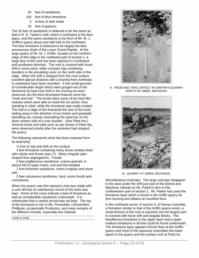
20 feet of sandstone. 100 feet of blue limestone.
2 inches of dark shale. 10 feet of gypsum.
The 20 feet of sandstone is believed to be the same as that in R. D. Tasker's well, which is northwest of the Burt place, and this same sandstone is the floor of Mr. M. J. Griffin's quarry about one-half mile to the northwest. The blue limestone is believed to be largely the blue arenaceous shale of the Lower Grand Rapids. At the large quarry of Mr. M. J. Griffin, located on the northern edge of this ridge in the northwest part of section 1, a large face of the rock has been opened in a northwest and southwest direction. The rock is covered with loose drift in some parts, while compact clay containing boulders is the prevailing cover on the north side of the ridge. When the drift is stripped from the rock surface excellent glacial striations with a bearing from northeast to southwest have been revealed. A few small grooves of considerable length which were gouged out of the limestone by hard rock held in the moving ice were observed, but the best developed features were the "knob and trail." The knobs were some of the hard flint nodules which were able to resist the ice action, thus standing in relief, while the limestone was easily eroded. The trail is a ridge of the limestone the size of the knob trailing away in the direction of ice motion and gradually dwindling out, closely resembling the sand bar on the down stream side of a river boulder. (See Plate IIIa.) Several knobs and trails such as are shown in Plate IlIa, were observed shortly after the workmen had stripped the quarry.
The following represents what has been exposed here by quarrying:
½ foot of clay and drift on the surface. 4 feet limestone containing many druse cavities lined
with calcite and brown spar (?). Many irregular pipe-shaped lime segregations. Fossils.
2 feet argillaceous sandstone, coarse grained, in places full of ripple marks, soft and thin bedded.
1 foot brownish sandstone, colors irregular and stone soft.
2 feet calcareous sandstone, hard, some fossils and concretions.
When the quarry was first opened a test was made with a core drill but no satisfactory record of the work was kept. Some of the cores indicate a bed of limestone as well as considerable sandstone underneath. It is unfortunate that a careful record was not kept. The top of the limestone is rich in life, Fenestella, Lithostrotion, Phillipsia, occasionally Productus, and many remains of the different crinoids, especially the Cidarida.
A. KNOB AND TRAIL EFFECT IN GRIFFIN’S QUARRY
NORTH OF OMER, MICHIGAN.
B. QUARRY AT OMER, MICHIGAN.
Miscellaneous Outcrops. The large outcrops disappear in the west under the drift just east of the Detroit and Mackinac railroad on Mr. Parker's farm in the northwestern part of section 2. Mr. Parker has used the limestone layer which is found in the Griffin quarry for lime burning and obtains an excellent lime.
In the northeast corner of section 3, of Arenac township, a formation similar to that of the Griffin quarry exists, a small amount of the rock is exposed, but the largest part is covered with loose drift and angular blocks. The fossiliferous limestone is the upper layer and a ripple marked sandstone is all that could be found underneath. The limestone layer appears thinner than at the Griffin quarry and most of the exposure resembles the lower layers in the quarry and the surface rock at Point Au
*Letter to writer.
Publication 11, Geological Series 8 – Page 19 of 55
Gres. The extent of the rock which lies near the surface is nearly 150 acres. It has been analyzed with the following results, which show it to be quite a clear limestone:
The other outcrops of Maxville limestone are similar and serve as a guide to trace the formations to the northwest. There are rumors of an outcrop in section 30, T. 20 N., R. 5 E., but this was not confirmed. At Melita post office in section 22, some wells were said to reach limestone at 18 to 20 feet, but the records vary greatly at this place and are not confirmed, although in a well east of this post office, rock was reached at 30 feet. The well at the Methodist parsonage at Melita is 89 feet deep beginning in quicksand and ending in clay. In the bed of the Rifle river at several places in section 7, T. 20 E., R. 4 E., a flat sheet of rock covers the river bottom for a hundred feet, and is exposed only when the water is low. This is a bluish sandstone which effervesces freely with acid and contains numerous fossils, among which are Productus, Spirifer and Fenestella. Some remains resembling plant forms were present and may be Fucoids or possibly worm tracks. The river banks at the outcrops are very high and entirely of glacial drift with no trace of the bedrock in the banks. These outcrops are believed to be nearest the top of the Upper Grand Rapids or Maxville of any in the county.
THE LOWER GRAND RAPIDS. Distribution. The series of deposits which contain the large beds of gypsum in Michigan have been named the Lower Grand Rapids of the Michigan Series, from the extensive outcrops in the vicinity of Grand Rapids, which is a local center for the manufacture of plaster of Paris and land plaster. The formation at Alabaster in Iosco county belongs to this series, and as it is much larger, in fact is the largest of its kind in the county, the name Alabaster, as has been suggested by Lane,9 could with propriety be applied to the Lower Grand Rapids had not Winchell applied the term Michigan Salt Group to them. The gypsum beds at Alabaster dipping slightly to the southwest, are worthy of careful description, for considerable information is thus obtained which can be applied directly to the beds in Arenac county. The Alabaster outcrop is a bed of white gypsum averaging about 23 feet in thickness; it is covered with 9 to 11 feet of brown boulder clay, while some sand and gravel occurs in pockets in the clay. Beneath the clay, in some of the irregularities on the surface of the plaster bed is a smooth blue clay and glacial boulders with evidently a different history than the brown clay. This large bed at Alabaster10 was originally two beds separated by a small layer of hard fossiliferous limestone and shale which has
disappeared during the progress of quarrying. At the time that Dr. Rominger11 observed the Alabaster formation, only the top bed was uncovered and the work was then near the lake shore. At the present time the face of the quarry is more than a quarter of a mile from the point where it was first opened and the lower layer (really a middle layer) observed by Dr. Rominger has thinned out and disappeared.12
The upper part of the gypsum formation is mottled and streaked like castile soap with small irregular seams of clay, while the middle part of the bed is pure white, and the bottom layers have a tinge of red and contain many nodules of gypsum embedded in clay. In the gypsum layers, because of the method of its formation by excessive evaporation of salty water from a former sea like the present Great Salt Lake or the Dead Sea, there is no evidence of former life, but in the small bed of shales and hard limestones which was formerly between the two gypsum layers the following fossils were found: Myalina, Allorisma, Aviculo-pecten, Pinna maxvillemis, Retzia gibbosa, Spirifer speciosa and an Orthoceras.
In 1900 a shaft was sunk in the bottom of the quarry, and reports place its depth nearly 90 feet. The writer was on the ground when the work was nearly completed and it was then 80 feet deep. The underlying rock was a blue grayish sandstone, very hard, alternating with seams of hard cherty limestone and brownish sandstone. At various depths, small beds of gypsum occurred, but their thickness decreased with the distance from the surface, although at 85 feet a 5-foot bed of white gypsum was reported but was not confirmed, and is regarded as rather doubtful. At 90 feet a soft white sandstone was reached and contained water under head strong enough to fill the pit. From the character of the water and the presence of the white sandstone, this is no doubt the top of the Napoleon sandstone, which is the formation underlying the Lower Grand Rapids series. When it is remembered that the salt and test wells at East Tawas reach a red "paint" rock at about 100 feet which clearly defines the top of the Lower Marshall, it appears that the white sandstone at Alabaster must be the Napoleon or Upper Marshall. The careful identification of this sandstone is of importance, as it is the only source of a permanent supply of nearly fresh water for the deep wells in Arenac county. The elevation above tide of the top of the gypsum bed at Alabaster is 604 feet; and this gives the Upper Marshall or Napoleon sandstone an elevation of 514 feet A. T. The dip in this region from Bay City to East Tawas averages 15 feet per mile. For the distance (11 miles) from Alabaster to Turner the dip is 83 feet (604 feet — 83 feet = 521 feet A. T.) which gives 521 feet A. T. as the elevation of the gypsum beds at Turner. Compare this result of 521 A. T. with the elevation of the second gypsum bed in Schwartz's well (No. 28 (650 feet — 140 feet = 510 feet A. T.) 510 feet A. T., and the difference is so small that we may be practically certain that the second gypsum bed encountered about Turner and in the county south is that of the Alabaster quarry. Taking 90 feet (the depth to the Napoleon sandstone at Alabaster) deeper we have
Publication 11, Geological Series 8 – Page 20 of 55

Publication 11, Geological Series 8 – Page 21 of 55
at 420 feet A. T. (510 feet — 90 feet = 420 feet A. T.) the top of the Napoleon at Turner or, in the Schwartz well (650 feet — 420 feet = 230 feet) about 220 feet to the Napoleon, and this is very near the horizon at which fresh water was reached in the latter well. In the study of the gypsum beds in Arenac county, comparisons of this kind with analyses of the water from different beds and the drillers samples have afforded much aid in locating the beds which may be of commercial value in the future. 9Geological Survey of Michigan, Volume VII, Huron county, p. 13. 10Geological Survey of Michigan, Vol. IX, The Alabaster Area, p. 68. 11Geological Survey of Michigan, Vol. Ill, p. 106. 12Mr. McCaslin, formerly in charge of the Alabaster quarry, is the authority for this statement and he directed the writer to several places near the entrance of the quarry where parts of this middle layer can still be seen.
The Gypsum Beds. The record of the Schwartz well shows a bed of gypsum at 51 feet (599 feet A. T.), which, according to the driller's record, was some 22 feet thick, and because it is the first bed of any size penetrated in drilling about Turner, it might be called the first gypsum bed or the Turner bed, while the second or lower stratum is the Alabaster bed. These two beds appear to be continuous from the Turner region to Bay City where they are clearly shown in the various well records of that city and Saginaw.13
The Alabaster bed was penetrated in the Omer town well (No. 12) at 200 feet, while in the Au Gres region the TJllman well (No. 13) reaches a small gypsum bed at 250 feet. In drilling the town well (No. 33) at Turner, the Alabaster bed was passed at 150 feet. No evidence of the lower bed was found when the Applin well (No. 36) was drilled north of Turner, although many small gypsum streams occur near 100 feet in the Clucky well (No. 32) which is east of Turner. At 95 feet, in the last well there is a 6-foot gypsum bed. The gypsum records which are difficult to correlate with the majority of drillings in the county are those from the French well (No. 21) which passed a 14-foot bed near 100 feet and the Cole well (No. 16) with beds at 100 and near 200 feet respectively. (Although if we can assume the dip from Alabaster to the Cole well to be 12 feet per mile, (604 feet — 120 feet [12x10] = 484 feet A. T.) which is within 6 feet of the first bed). But on the whole the beds as reported in the records of the French (No. 21) and Cole (No. 16) wells are not to be relied upon as they were reported from memory by a well driller. The Applin well (No. 36) passed the Turner bed of gypsum at 23 feet below the surface (607 feet A. T.), and from all the records which are available of the region to the north of Iosco county no trace of this bed appears. The dip and the character of the topography is such that it must emerge before Alabaster is reached. The Turner bed is believed to be higher in the series than the main beds at Alabaster, and of the same heights as the beds exposed in the bottom of Cranner creek southwest of Whittemore. The bed of Johnson creek at the Keystone dam, in section 30, T. 21 N., R. 5 E., is some eight feet higher than the top of the
exposure in Cranner creek and the rock found here corresponds so closely to the beds at Barmon City that its position in regard to the gypsum must be the same. At the Keystone dam there is exposed about 800 square feet of rock surface. The beds dip slightly to the southwest and the stream has cut a channel at least 10 feet deep in the rock for a distance of over 500 feet at this place.
The following description applies to the Keystone dam formation:
Two feet limestone. This is the top layer which is brittle, gray and somewhat arenaceous. Small druses containing calcite crystals are scattered abundantly through the bed. Fossils, especially Allorisma are quite numerous. Greenish stem-like bodies of irregular shape occur similar to some of the branching forms of the Bryozoa. The lower part of this layer is filled with flint nodules such as are found at Harmon City.
Three feet limestone. Dark and brittle. This is filled with irregular lime concretions like those which occur in the Griffin stone quarry north of Omer.
One foot sandstone. This is a dark gray color and contains irregular formations. These are somewhat similar to fucoids and are rich in lime.
Four feet limestone. Compact, gray in upper part of bed but it becomes more arenaceous in lower part which contains fossils and some cavities of calcite crystals.
At Whittemore, in the wells of Mr. Curtis, the Turner and Alabaster beds of gypsum appear at 687 A. T. and 607 A. T. respectively. 13Mich. Geol. Survey, Annual report for 1901, pp. 224-225. For Grayling well, see p. 232. Annual report for 1905, Bay county, p. 152-153. Volume V, Part 2, p. 50.
County Line Outcrop. Near the county line between Iosco and Arenac counties, north of Turner on the Detroit and Mackinac railroad, where it crosses the east line of section 36, the covering of the Turner gypsum bed is well exposed for nearly 200 feet on the sides of the track in the three foot cut which was made for the railroad grade. The outcrop is covered by the drift in all parts of the near vicinity. The land at this place is a low but distinct ridge crossing the railroad track at right angles and its prominence is perhaps due to the fact that it consists of the hard calcareous sandstone which occurs just above the gypsum at the Keystone dam in Iosco county, at Harmon City on the lake shore, and in the small test hole on the property of Albert Hann at Turner. The exposed gypsum along the railroad is a six inch layer with several layers of the hard cherty limestone. The cap of the outcrop is a hard brown limestone of a foot in thickness. Along the top of this drift covered ridge, which is quite pronounced would be a place quite suitable for further exploration for a gypsum bed sufficient for working on a commercial scale. The well records, especially the Applin (No. 36) and the Swartz (No. 28,) wells are good clues to what may possibly be expected in the size of bed to be found.
Publication 11, Geological Series 8 – Page 22 of 55
West of the railroad track near the center of this ridge, Mr. McLean several years ago dug a small experimental pit which was 15 feet deep. Judging from the material thrown out of this test pit, sandstone was found in abundance, some smooth gray limestone and gypsum in small layers. At the house of Mr. S. B. Dryer, which is west of the railroad and southwest of the low ridge a dug well was made through 6 feet of drift and 12 feet of a shelly brown sandstone and one foot of blue grayish shale. No gypsum was found by the writer who examined the well shortly after it was made.
The Turner Gypsum Bed. The Turner gypsum bed is believed to emerge on the Lake Huron shore north of Harmon City where the Whittemore test shaft was sunk in 1870. This place is located near the east quarter post of Sec. 13, T. 20 N., R. 7 E., in Arenac county, and the steep banks along the lake are 15 or 20 feet high, and wave action has exposed a considerable section. At the water's edge is a layer of clay gypsum, filled with selenite crystals, nodules of pure white gypsum, and thin streaks of hard white limestone. The overlying rock is the blue and brown sandstone of the Maxville series, which outcrops on the lake shore to the south a short distance. When this test shaft was made by Mr. Chas. Whittemore, a ten foot seam of gypsum was reported to be near the surface and this is no doubt the white rock which is seen off the shore at this point in some 15 feet of water. This bed apparently corresponds to the Turner bed and emerges between this outcrop and Alabaster.14
The records of wells which have penetrated the Turner or upper gypsum bed are very numerous and of sufficient number so that the general elevation and thickness of the bed can be recognized throughout a large part of the county. In all the discussions bearing on the gypsum beds, the deep wells at Standish have to be omitted, as their records are not complete, and when drilling in the Michigan series little attention was given to the location and number of gypsum beds penetrated. The Turner bed was reported at a depth of 52 feet in the Turner town well (No. 33), west of the village in the Rosenthal well (No. 34) at 46 feet, in the wells of Swartz (No. 28) and Applin (No. 36), which are northeast of the village, at 60 and 20 feet respectively. At the stone quarry of Mr. Burt the Turner gypsum was reached by a test drilling at 126 feet.15
In the Au Gres region the dip from Harmon City outcrop of the Turner bed and the general relation of the formation in the Swartz and Burt wells, indicate quite clearly that the gypsum in the Grimore well (No. 18) at 80 feet is the Turner bed. This corresponds to the gypsum in the French well (No. 21) at 90 feet and in the well on the farm of Mr. Cole (No. 16) at 70 feet.16
The distribution of the Turner bed is quite uniform throughout the county, its north edge being quite near the surface on a line from the Applin well to the Whittemore test shaft on Lake Huron and dipping gently to the southwest. In the region of the Au Gres river along the above line the gypsum as well as other rock layers have been eroded away. It appears in all of the
wells drilled in this region in the relations to other formations shown upon the cross-section. (Fig. 3.) The only marked variation from this arrangement of the Turner bed is the country about the village of Au Gres. The records from the Oman well (No. 13) show a bed of gypsum at 45 feet. This bed if allowed the average dip of rock in the region, would be at the surface at the Grimore well, (No. 18) and very near the surface in the village of Au Gres. Some dug wells in ibis village have reported some gypsum at 10 to 20 feet but the reports were not confirmed. Still the presence of tins bed in the Oman well and the reports of gypsum from the shallow wells in the village, would strengthen the report of Bela Hubbard,17 who pointed out the presence of large beds of gypsum at the mouth of the Au Gres river. On the other hand the writer has a statement from Capt, A. T. S. Smith, who did some dredging at the mouth of this river, that in his work rock was never observed, and again a letter from Capt. Geo. Grimore, who has charge of extensive rafting operations at the same place, affirms that no such beds are present. A small bed may exist here in spite of the conflicting statements and if it does it is local in outcrop and above the Turner bed. 14580'—15'=565'. Top of Turner gypsum bed at Whittemore test pit. Say dip=15' per mile, a little high. 4.5 x 15'=75'. 565' + 75'=640' A. T. of top of Turner gypsum bed at Alabaster, which is 607'. The two beds are not the same stratum. 640'- 607'=33' feet= difference between two beds. 15Letter from Mr. Burt giving record of drilling made in 1901, see page 50. 16From Harmon City to the Grimore well is 7 miles. 570' —500'=70 '÷7=10' dip per mile. 570'-505' (65 x 7.65)=Cole well (495=top of first gypsum in Cole's well). 17"A Michigan Geological Expedition," Michigan Pioneer and Historical Collections, Vol. Ill, page 199.
THE NAPOLEON SANDSTONE. Distribution. This important formation underlying the Michigan Series, is without an outcrop in the county but its chief characters are well known from numerous wells which draw on it for their water supply. It consists of a white to gray porous sandstone of some 70 feet in thickness, which allows the accumulation and circulation of large quantities of water. The rock is rather soft, and rapid drilling is always reported when this horizon is struck. In the geological history of the formations in the Lower Peninsula of Michigan, the Napoleon sandstone was laid down in the southward retreating and open Paleozoic sea. The sandy character of the formation is thus explained. These formations of sandstones and clays representing the shore line of the ancient sea, can be roughly traced by following the Napoleon (Upper Marshall) through New York, through Ohio, by the Logan conglomerate into Michigan, and thence westward. After the retreat of the water from this region, additional folding occurred in the formations which make up the great geological basin which is local to Central Michigan, and then, the Michigan series consisting of the Upper and Lower Grand Rapids were formed on the white and gray sandstone of the Napoleon. The climatic
Publication 11, Geological Series 8 – Page 23 of 55
conditions18 were those of an excess of evaporation over the precipitation which resulted in the formation of gypsum and salt beds in the inland sea of the Central Michigan basin. The gypsum beds being the first deposited, were interspersed with beds of limestone and clay shales in periods of excessive precipitation or freshening of the water and washing in of the muds from the shores. 18Geological Survey of Michigan, Vol. IX, page 185-187.
Value of the Napoleon sandstone. The greatest interest to us in this history of events, is that it may explain the reason for the peculiar distribution of the waters of various quality in the formations of this county as well as throughout the state. It is generally true that the deeper wells within certain depths yield a water which contains less of the salts than do the shallow wells from the Michigan Series. Let it be recalled that during the period following the cutting off from the sea of the Michigan basin, when precipitation was taking place and the Michigan series of gypsum were formed, the underlying rocks of the Napoleon sandstone were saturated with the most easily dissolved of the ocean salts, sodium chloride. This would help to account for the Napoleon water always being lower in sulphates which are less soluble, and high in the chlorides which pass more readily into solution, and this formation of sandstone near the center of the basin is the "'first salt bed."19
This is not all, for when the basin-like arrangement of these formations is taken into consideration, and the position of the sandstone outcropping on the rim, the source of the head and the supply of many of these wells in this formation is seen. Thus the water through this region and near the center of the basin, is under a head strong enough so that its general motion will be towards the surface, rather than percolation to a greater depth. These are the main reasons for believing that the supply for many of the stronger flowing wells is derived from the rainfall upon the drift covered outcrops of the Napoleon to the north of this county. The salts which are present in the water are so free from gypsum and so high in the chlorides that the supply must be due to the water working upwards from the lower salt beds of the Marshall. 19United States Geological Survey Water Supply Papers No. 30 and 31.
CHAPTER VI. PLEISTOCENE GEOLOGY—GLACIAL
HISTORY.
INTRODUCTION. This county is in the drift-covered region of the northern part of the southern peninsula of Michigan, being a part of the great drift area of the north central and eastern states and Canada, whose surface before the glacial period was one of mature dissection with wide, well silted river valleys and usually with no marked elevations or irregularities. The rock surface in Arenac county as well as in the other counties of the Saginaw Bay region has been almost entirely veneered with a coating of varying thickness of glacial drift, which has entirely changed its general preglacial appearance and moreover produced a very fertile soil.
The former covering of the land of the Great Lake region by a great body of ice is known from the peculiar character of the soil and also by its comparison with the present conditions in other lands such as Greenland and the Antarctic lands, which are still ice coverd. The last great ice body, called the Laurentian ice sheet, which covered this region changed the drainage of the Great Lakes, closing the former outlets and forming new ones.1
The former high water level of the Great Lakes is now plainly marked by a series of old beach lines roughly parallel with the present lake shores and high above the prsent lakes.2
Arenac county is largely within the former extension of a water body in the basin of Lake Huron and hence its surface features are those due largely to lake deposits as well as modified by postglacial weatherings and stream action. 1History of Great Lakes: Dryer's "Studies in Indiana Geography" by F. B. Taylor. Also Outline of the History of the Great Lakes: Michigan Academy of Science, Twelfth Report 1910, pp. 1942 by Frank Leverett. 2For general account of the glacial lakes see Surface Geology of Michigan by A. C. Lane, Annual Report of Michigan Survey for 1907.

Publication 11, Geological Series 8 – Page 24 of 55
GLACIAL DEPOSITS. Soil is a result of the disintegration of rock. The solid rock of ledges may be disintegrated by percolating waters, frost action and the various agents of weathering. This disintegrated material or rock waste is a residual soil when it lies on the bedrock of which it was once a part. When such material covers a region where the underlying rocks could not form it, other explanations of its origin must be offered for the "foreign" soil. In this region the Laurentian ice sheet is very obviously the agent which has carried the soil or glacial drift to its present position. The present distribution of this drift in eastern Canada, Wisconsin, Michigan, and all the states north of the Ohio River shows the enormous extent of this former ice sheet, which was much larger than the present ice sheet of Greenland. This ice sheet has been the means of furnishing a soil of great fertility to much of the region which it covered. This glacially transported soil covers almost all of the rock surface in Arenac county and it contains large boulders of granite and various other rocks which differ entirely from the underlying white sandstone of the Marshall series, the gypsum of the Grand Rapids and the limestone of the Maxville formations. Many of these granite boulders were broken or "plucked" from the parent rock ledges which are located on the opposite or northeast shore of Lake Huron and then transported by the ice sheet to their present location in this county.
The rock waste that is distributed over the land by glacial action is deposited in various forms. In this region the most prominent land features are the glacial formations known as moraines, wide spread plains of boulder clay, and the "sand plains" or sheets of over-wash material. The moraines were built at the edge of the ice from the rock material carried by the ice sheet, thus they mark the location of the ice border at the different stages of its retreat from the land. The moraines are located in a somewhat systematic manner in Michigan about the basins of the present Great Lakes. Accompanying the morainal deposits are the "sand plains" of overwash materials which were carried away from the ice front by water action. The till plains are wide spread areas of boulder clay formed beneath the ice and located on the iceward side of the terminal moraines. They are generally flat and poorly drained but otherwise are the most fertile of any of the glacial regions.
In the lower portions of the ice sheet and beneath the ice there was a large amount of material which had been gathered from the country rock passed over. The ice left much of it as it advanced, building a bed of varying thickness upon the rock surface which is called the ground moraine. The remaining material was carried to the end of its course, and there spread out in irregular, rolling mounds of unstratified material forming the terminal moraine. When the ice melted from the country, there was not a continuous and steady shrinking of the ice sheet but places where the margin remained nearly stationary for a period long enough to enable the ice to leave large amounts of material and spread out other
terminal moraines inside the limits of those already formed. In this way several moraines were formed In somewhat concentric lines across the lower peninsula of Michigan before the ice retreated.
The sinuous or looped course of many of the moraines indicates that the movement of the ice sheet was greatly influenced by inequalities in the surface of the country rock over which it passed; there being more free and rapid movement through low districts, such as the basins occupied by the Great Lakes, than over the bordering higher lands. This resulted in the formation of the ice lobes that have received names from the respective basins in which they stood, as the Lake Michigan lobe, Saginaw Bay lobe, Huron-Erie lobe, etc. Arenac county is in the region formerly occupied by the Saginaw Bay lobe. The lobes coalesced into a massive ice cap when the ice was at its maximum, but they again became prominent in the retreating stage, and because of their shape and location the moraines which were produced in the retreating stage are looped around the basins, and are named from the ice lobe which formed them.
THE PORT HURON MORAINIC SYSTEM. The heavy well developed morainic system which passes in large swinging loops through the counties west of Arenac was built by the Saginaw ice lobe prior to the development of the Port Huron system, and is easily traced from Clare county past West Branch in Ogemaw to Rose City, then to the Au Sable River in the southwestern part of Alcona county and to the northwest into Oscoda county. When this lobe gradually withdrew, it stood for a time at a lower level to the east and built the Port Huron morainic system so named from having been identified near that city and since traced northward about Lake Huron.
This system is somewhat complex in the vicinity of Arenac county as determined by Leverett and Taylor. The outer moraine is found west of Alger, almost on the Arenac county line, and passes northeastward, a short distance south of Greenwood, to Rifle River, thence north to Sage Lake and east into Iosco county near Long Lake. It appears north of the Au Sable valley near Vaughn, P. O., or Glennie in Oscoda county. When the ice stood on this moraine, the entire drainage of the region was south along the edge of the ice in a rather broad stream, which was greatly overloaded with the glacial detritus. (Fig. 5.) This material was formed into broad sandy plains, some of which are the so-called "Pine Barrens'* of lower Michigan. The old course of the water may be traced from near South Branch in Iosco county where a series of lakes and swamps lead from the present Au Sable river to the present headwaters of the Rifle, from which the water followed the present course of the Rifle to near its west branch, where the glacial waters were discharged to the west and reached the east branch of the Tittabawassee through the present low swamps north of Greenwood.

Fig. 5.—Early drainage of the Rifle and Au Sable Rivers
southward through the Greenwood swamp to the Tittabawassee.
When the Saginaw ice lobe withdrew from the first crest of the Port Huron moraine it moved only a short distance, as the second crest of this moraine is in Arenac county just west of Moores Junction. It passes northward to Summit on the Michigan Central Railroad and to the east side of the valley of the Rifle river, where it is located west of Martin's Corners, passing through the township of Clayton with a well developed crest of one-half to one mile in width, being the highest near Turner's Corners. (860 feet.) This crest of the Port: Huron moraine passing northward and to east of Prescott forms a distinct ridge and then bends to the northeast, crossing the Detroit and Mackinac Railroad near Taft in Iosco county and the same crest appears on the north side of the An Sable river near Bryant.
When the ice stood on this moraine the drainage of the An Sable river seems to have been along the edge of the retreating ice southward through the pass in the present low swamp between Alger and Summit, thus reaching the headwaters of the Molasses river and thence southward to the Tittabawassee. A large level sand plain was formed between Alger and Summit by the water discharging through this pass. The small sand plain about Shearer and those in the vicinity of Bush lake belong to this same plain. (Fig. 6.)
THE ALCONA MORAINE. The Port Huron moraine determined the features of the northwestern part of Arenac county and when the Saginaw ice lobe withdrew from it, another well marked moraine was not built in the county. A moraine was formed, however, at a lower level in Alcona county and Iosco and it has been traced southwest to Seven Mile Hill on the Au Sable and Northwestern Railroad. This moraine, called the Alcona moraine, is developed south of the Au Sable river in a small morainal district northwest of Tawas Lake in the township of Wilbur and to the south of this region it seems to be faint and evidently passed under water forming some of the water-
laid clays along the eastern edge of Iosco county about Alabaster and Au Gres.
Fig. 6.—A later stage of the drainage shown in Fig. 5.
LAKE FEATURES.
Fig. 7.—Lake Warren in Arenac county.
Lake Warren (Forest Beach). When the Saginaw ice lobe slowly withdrew from the second crest of the Port Huron morainic system, the drainage of the Rifle river valley passed into a glacial lake in the Saginaw basin known as Lake Saginaw which, with further recession of the ice, became merged with a lake in the Huron-Erie basin called Lake Warren. Some shore features of the lake are to be seen northwest of Sterling. The water level of this lake during the highest stages in this region seems to have been from 750 feet to 770 feet and at this time the Forest beach of the expanded stage of Lake Warren was formed. Lake Warren extended over a large part of the present basins of Saginaw Bay, the south part of Lake Huron, and Lake Erie, and discharged its waters through the present valley of the Grand River to Lake Chicago, a glacial lake in the Michigan Basin, and thence to the Mississippi by the southwest outlet through the Des Plaines and Illinois. This lake bordered
Publication 11, Geological Series 8 – Page 25 of 55
Publication 11, Geological Series 8 – Page 26 of 55
the Saginaw ice lobe as far north as Iosco county, but, in Alcona county, the lobe outside rose above the level of Lake Warren. It is believed that the drainage of the present Rifle river system reached Lake Warren during its highest stages near the present Pinnacle Hill region in Arenac county. (Fig. 7.) The Forest beach is a marked feature at Quinns on the Michigan Central Railroad, northwest of Sterling, where a well developed sand beach has been found on the eastern face of the Port Huron moraine whose summit is reached a short distance to the west. The top of the Forest beach at this place has an elevation of 782 feet. From Quinns eastward for nearly a mile there are a series of sandy ridges which decrease in height and were formed by the receding edge of the lake. Where the Michigan Central Railroad crosses the western line of section 18, a marked beach is developed whose top is 775-785 feet, which seems to indicate a relatively long period during which the lake level was nearly stationary. The bottom of this beach, is still better developed in the northern part of section 18, where it has an elevation of 780 feet with a general northeast trend. At the northeast corner of this section (18) it turns sharply to the north and follows for half a mile the eastern line of section 7, then it bends to the northwest, passing into the valley of the Rifle where it forms a terrace at 770 feet on the west side of the river in section 36 and 31 of Moffat township. It is at this point that the Port Huron moraine is cut by the river valley which is here relatively narrow, while north of the crest of the moraine the valley is more open. The general elevation (770 feet) of the surface north of this moraine indicates that Lake Warren had a bay, which may perhaps be termed "Well's Bay,” in sections 34, 27, 26, and all of the land south of Well’s creek and between the Michigan Central Railroad and the Rifle river. The present bed of Well's Bay is very level, sandy, and of the same elevation (770 feet). When the water of Lake Warren stood at its highest elevation the discharge channel was through this bay to the southwest and, as this gradually filled and the general lake level was lowered, the waters were diverted to the Pinnacle Hill region. In Clayton township, east of the Rifle river, Well’s Bay occupied all of sections 18, 7, 8 and 17. In many places in this former bay there are at present small lakelets, a good example of which is located two miles east of Wells.
In the township of Clayton in section 31, on the eastern bank of the Rifle, there are many distinct terraces at 780 feet. At this place one mile east of the present river bottom, there are indications of the former shifting of the stream's course, which took place when the stream was 60 to 80 feet above its present level. The deep gullies and abandoned ravines which are found here are out of adjustment with the present stream course. Northward along the Rifle river from the "high banks” in section 31, as soon as the crest of the Port Huron moraine is passed, the valley on the eastern side becomes more open and in the west half of section 19 and 30 there are beaches which are distinct and whose tops reach 770 feet. In almost all of sections 18, 7, 8, and 17 the
surface is very sandy and was formerly covered by "Well's Bay”, when Lake Warren formed the Forest beach at an elevation of 782 feet at Quinns. The level sandy plain southeast of Wells creek has a few small lakelets which are very shallow. A type of these is a small one called Cotton Lake, due east of Wells, two miles. It is shallow, an eighth of a mile in circumference, entirely filled with sedges and rushes which in summer give it a "cotton" appearance. Many extinct lakelets of this character occur on the sand plains. Mr. Ferris Stone found one of these sinks near center of section 6, Clayton township, to be nearly elliptical in outline with the greater axis, about a tenth of a mile. It was 8 to 10 feet below the surface of the plain and its bottom filled with peat 15 feet thick in places. These "pits" are found in several places on this plain and may be formed from the berg ice being stranded and the material accummulatirig about it. They are entirely within the sand plains and are not as deep or narrow as the ice block holes of the moraines. Very distinct beach lines of the Upper Lake Warren (Forest) series were made in the southeast corner of section 6.
In Adams township, southwest of Sterling, the Forest beach has been traced to the Bay county line, where Mr. W. F. Cooper has identified this beach near the southeast corner of section 5, township 18, R. 3 E., and from the southwest corner of section 31. At this place, the beach has an elevation of 762-770 feet and has been traced northward to the point already noted on the west line of section 18 in Deep River township. West of Moores Junction, in section 33, is a sandy surface from 770 to 790 feet A. T., which is quite likely the southward extension of this beach. Following the Mt. Forest branch of the Michigan Central Railroad southward nearly to Bentley is a sandy ridge which ranges from 760 to 780 feet, belonging to the Forest beach. The Forest beach in Adams township passes northward from Moores Junction near the center of section 27, going diagonally across section 23, northward in the eastern half of section 14, to Quinns on the Michigan Central Railroad, in section 13.
In the vicinity of Moores Junction and in fact extending the entire distance to Summit on the Michigan Central Railroad, the second crest of the Port Huron moraine varies from one to two miles in width and on its eastern slopes are the beach lines, while on the west of the moraine, where the glacial waters once discharged, the sand has been distributed in an even plain which corresponds in elevation to some of the Lake Warren beaches to the east. Somewhere to the southwest in Bay county some of the Forest beaches ought to be found passing around the end of the Port Huron moraine and along the west edge of this moraine for a short distance.
The Sterling Spit of Lake Warren. At the time of the formation of the marked Upper or Forest beach at an elevation of 780 to 770 feet northwest of Sterling in section 18, there was made from the great amount of sediment several bars and spits at a distance of one to

Publication 11, Geological Series 8 – Page 27 of 55
two miles in front of the beach. In the southwest corner of section 18, a curved ridge stands 15 to 25 feet above the level of the till plain, and extends eastward from the Michigan Central Railroad to the corner of this section, and, in section 20, it has a southeast trend and gradually blends into the dunes and sand plains which are some distance east of Sterling. In section 20, the spit has a course due east and is on the average 400 to 500 feet wide and nearly three-fourths of a mile in length. Near the Michigan Central Railroad, it has the least width and is the highest. Its elevation here is near 773' A. T. The material is fine white sand, no pebbles being present. It stands in marked contrast to the heavy clay on which it was built.
The Pinnacle Hill Delta. While the Sterling spit was being formed, the greater part of the sediment was carried by a glacial stream occupying the present headwaters of the Rifle river. This material was discharged into Lake Warren in this region and formed a large delta, which comprises the present Pinnacle Hill and the "Plains" of Arenac county. The formation covers all of sections 9, 10, 11, 12, 2, 3, 4, and a part of sections 16, 15, 21 and 14 of township 20 N. and R. 2. This is a sandy waste on which nothing has grown but the "Jack Pine" flora, and, about the edge of this district where the clay is near the surface, the Norway and White pine were formerly abundant.
Pinnacle Hill is the highest part of the old delta with an elevation, by the aneroid, of 780 to 795 feet. A careful series of levels by John McFarlane gives 745 feet as the elevation of the river bottom at Pinnacle Hill and the depth of the valley at this place is 150 feet, thus giving 705 feet as the highest part of Pinnacle Hill. The land for one mile south and east of Pinnacle Hill is very flat and slopes from 765 feet at the base of the hill to 745 feet at the edge of the delta cap. Skirting the edge of the delta cap is a belt of sandy country extending from Sterling to Omer, on which the smooth rolling features, due to current action when it was formed, are just now commencing to show the recent creek action. In some of the depressions, the creeks of the county have their origin in the water which collects beneath the sands and follows the slope of the clay to the south and appears again with a good volume of water at the edge of the sand plains. The volumes of these small creeks are remarkably uniform when compared with those of like size which are entirely in the clay regions. The material which forms the entire Pinnacle Hill delta is sand of uniform texture—pebbles are almost absent. This would indicate that the glacial stream which discharged at this point into Lake Warren was on a rather low grade and heavily loaded.
The present size and shape of the delta is smaller than when formed, as the Rifle river has encroached upon its northern edge and removed by lateral cutting a considerable part. The formation under the delta sand is a very compact, drab clay which is exposed in all of the convex banks of the river. Beneath the clay is the bedrock of the Saginaw Coal Series. This clay of the
delta is entirely free from pebbles and boulders and evidently was deposited well away from the edge of the ice. However, a short distance up stream in the Rifle river from Pinnacle Hill the clay of this character disappears and the banks are a tough blue clay filled with boulders indicating the location of the Port Huron moraine.
Lower Beaches. Beaches were formed when the lake waters had fallen to near 725 feet in T. 18 N. R. 3 E. In Bay county, W. F. Cooper3 found these beaches in section 20, township 18 N., R. 3 E., at an elevation of 722-727 feet A. T. The same beaches exist in Bay county in the northeast corner of section 9 of the above township at an elevation of 721-733 feet. In the center of section 3, the same sandy ridges have an elevation of 716-728 feet and extend to the northeast. In the southeast corner of the same section, beaches are well developed at 721-733 feet. In Huron county Lane4 locates beaches about ten feet below the Upper Warren (Forest) having an elevation of 749-739 feet.
A lower beach than the Forest has been traced through parts of Gibson township in the sections above noted by Cooper to the northeast into Arenac county where, in Adams township, on the east line of section 35, it is well developed with an elevation of 733 feet. Traces of it can be found extending through to the eastward in section 25 of the above township and in sections 19 and 20 of township 19 N., R. 4 E. Near Sterling the beach is not strongly developed, but a gravel ridge northeast of the village has an elevation of 745 feet. Further to the northeast of Sterling the border of the lake shore at this level was in the sand of the Pinnacle Hill delta. At the center of section 21 is a sandy point which has an elevation of 725 feet, while in sections 15 and 10 only slight traces of beaches occur in the many rolling sandy ridges which extend southwest into the valley of the Rifle. In this valley, a well marked terrace occurs east of Alger at 745 feet and the edge of the valley is quite sharply marked by cliffs in the Pinnacle Hill region at 750 feet.
In Clayton township, on the north side of the Rifle river valley, traces of the lower beaches occur in the sand and gravels in the southeastern corner of the township. Near the center of section 24 of this township, a sandy ridge occurs at 750 feet and, in the southeastern corner of section 24, a faint ridge of coarse gravels occurs with an elevation of 751 feet. On the west line of section 35, there is a distinct terrace at 727 feet but this is more likely to be one of the lower lake levels probably Grassmere. Following the general trend of the gravels into Mason township of Arenac county, well developed ridges occur in section 24. Also at the north ¼ post of section 15 township 20 N., R. 5 E., is a well marked sand ridge which has an elevation of 746 feet. In the same section half a mile to the east is another well developed sand ridge which has features similar to this one and its crest is 740 feet. These beaches appear again on the north side of Big creek in section 11 and

there they have an elevation on the crest of 725-735 feet. 3Geology of Bay county by W. F. Cooper, page 344. Annual Report of the Michigan Geology Survey for 1905. 4Geology of Huron county by A. C. Lane, page 72. Geological Survey of Michigan, Vol. VII.
FIGURES 8 TO 17.
[Fig. 8. Profile of beaches at Alabaster.
Fig. 9. Section of back swamp at Algonquin ridge near south quarter post of Sec. 24, Lincoln township.
Fig. 10. Nipissing at King’s corners.
Fig. 11. Algonquin north from King’s corners (Sec. 5).
Publication 11, Geological Series 8 – Page 28 of 55
Fig. 12. Profile of Algonquin beach.
Fig. 13. Profile west from King’s corners, “High Banks”.
Fig. 14. Profile east from Omer.
Fig. 15. Profile from Lake Huron to Bluff (two miles south of Tawas City.)
Fig. 16. Profile from Lake Huron west (one mile south of Tawas City).
Fig. 17. Vinegar Hill.]
The Grassmere Beach. A beach formed at a still lower level has been called the Grassmere5 from a locality in Huron comity where Lane has located it at an elevation of 670 to 690 feet. In Saginaw county Cooper6 located the Grass-mere in section 9 in township 11 N., R. 1 E., with an elevation of 687.3 feet. In Bay county, he located the Grassmere7 at 688 feet in the northwestern part of section 11 of Gibson township. The Grassmere near the Mt. Forest railroad station has an elevation on the crest of 675 feet. There are some other beaches that are related to the Grassmere in Williams and Garfield townships which have a base of 660 feet. In Gibson township in the northeast corner of section 2 is a well developed beach at an elevation of 696’ A. T. This beach is traced from its location in Gibson township to west of Deep River station on the Michigan Central Railroad where in section 32 the sand area west of Standish from 660 to 675 feet is all that remains of the beach along the county line, while in Gibson township near the north ¼ post of section 2 is a sandy ridge at
685 feet. Farther to the east in Lincoln township at the northeast corner of section 16 is a heavy sand ridge with an east and wrest trend and on its crest it has an elevation of 650 feet. This beach blends with a sand plain to the east and loses its character as a ridge. In Deep River township this beach which has been correlated with the Grassmere is well developed near the north line of sections 34 and 35. In the northwest corner of section 35 is a high point of light sand at an elevation of 667-670 feet. This extends to the northwest into section 26 and the west side of this point extends into section 27. The terrace on the Rifle river at the Sterling bridge at 675 feet seems to be closely related to this beach. At Norn's bank on the Rifle river in the northwest corner of section 1, township 19 N., R. 4 E., is a well marked terrace at 662 feet. The sand plains northwest of Omer have a distinct drop at an elevation of 668 feet. In sections 31 and 28 of Mason township are sandy ridges from 660-670 feet which are well marked in places but are not continuous and have a general trend to the northeast. In the northeast corner of section 26 of the same township is a well defined sand ridge with some gravel which seems to belong with the same beach formation that occurs farther to the south. At the south 14 post of section 12, and extending to the east line of this section, is a well formed sandy ridge which has an elevation of 664-673 feet. 5Geological Survey of Huron county by A. C. Lane. Geological Survey of Michigan, Vol. VII, part II, page 74. 6Pleistocene Beaches of Saginaw County by W. F. Cooper. Michigan Academy of Science. Tenth Annual Report, page 92. 7Geology of Bay County by W. F. Cooper, page 345. Annual Report of the Michigan Geological Survey for 1905.
The Elkton Beach. A later successor of Lake Warren than Grassmere was Lake Dana. Its history is discussed in the Surface Geology of Michigan8 by Lane. In Saginaw county. Cooper located a beach9 at an elevation of 647-654 feet for the crest, which corresponds to the Elkton beach10 found by Lane in Huron county at an elevation of 649 feet. In Bay comity, Cooper finds a well developed beach evidently belonging to this series at 644-654 feet, in the townships of Williams, Beaver, and Garfield. In Arenac county, traces of a beach evidently the Elkton appear in Lincoln township at south ¼ post of section 28 where its crest has an elevation of 637 feet.11 This same beach crosses the east line of the above section. A trace of the same beach occurs in some of the terraces along the Saganing creek in sections 27 and 26 of Lincoln township. Along the South Fork of Pine creek are many ridges which can be correlated with the Elkton beach. In the northwest ¼ of section 12 are a series of ridges with a general northeast trend and an elevation of 630-688 feet, which is somewhat low for the Elkton. The same ridges are near the south ¼ post and the center of section 1 of Lincoln township and, in both locations, they have an elevation for the crest of 628-635 feet. The same ridges are in the northeastern part of section 2 of this township. A well defined ridge is found along Deep River in section 35 of Deep River township which has

Publication 11, Geological Series 8 – Page 29 of 55
the elevation on its crest of 647 feet. In the same township in the southwest corner of section 25 is a distinct ridge which is also at the south ¼ post of the same section and in the various places observed, this ridge has an elevation for its crest of 647 feet. In Deep River township in the northeast comer of section 36 is a sandy point which has an elevation on its crest of 635-640 feet, and its eastern slope is traced to the northeast into sections 25 and 19. Near the center of the latter section, the crest of the ridges stands at an elevation of 635-643 feet. North of Omer, the sand ridges in section 3 mark the first trace of this beach north of the Rifle river in this county. In section 19 of Arenac township is a well defined ridge along the south line at 630-635 feet.
The same beach is well developed in Iosco county in sections 30, 29, 28, 21 and in 15 of township 21 N., R. 7 E., where it stands as a very distinct ridge at an elevation of 647 feet. This same beach of Iosco county which has been correlated with the Elkton forms a sandy point in section 14 of the above township a short distance from the lake on the Alcona moraine. This beach extends to the northwest from this last location through sections 10 and 9. In section 8, it crosses the Detroit and Mackinac Railroad where its crest has elevation of 650 feet A. T. This beach can be traced through the following sections of Tawas township in Iosco county. From the southeast corner of section 32, hence northeast to the south ¼ post of section 28, to the south ¼ post of section 22, to the south ¼ post of section 14, where it passes due north to the north ¼ post and into section 11 and hence to the north ¼ post of section 12. Its elevation for the crest throughout this course is 640-650 feet. In Sherman township of Iosco county in section 81 near the south ¼ post is a sharp ridge with a north and south trend which has an elevation for its crest of 632 feet. Gravels north of Mr. Swartz' house northeast of Turner at 658 feet and the ridge north of Pollack's house east of Twining which is 640 feet may also be associated with the Elkton. 8Michigan Geological Survey. Annual Report for 1907. The Surface Geology of Michigan by A. C. Lane, page 132. 9Michigan Geological Survey. Annual report for 1905. The Geology of Bay County by W. F. Cooper, page 347. 10Geological Survey of Michigan. Vol. VII, part II, Geological Report upon Huron County by A. C. Lane, page 79. 11This is an elevation taken with a Wye level by John Bloomfield and is supplied the writer by W. F. Cooper.
Lake Algonquin. Algonquin Beaches. Lake Algonquin was formed when the lakes covering the present great lakes, with the exception of the lower lakes, were merged into one large body of water which drained through Georgian Bay via. the "Trent outlet" to Lake Iroquois, then with the elevation of the land about this outlet the drainage was changed to Lake Erie. Later an outlet was opened from Georgian Bay through the Ottawa valley, and the lake level lowered to form the Nippissing stage.
(a) Southern part of Saginaw Bay. The Algonquin about the "thumb" of Michigan and Saginaw Bay has been identified and described by Dr. A. C. Lane in a report12 on Huron county and by Mr. W. F. Cooper's report13 on Bay county. In Huron county the Algonquin beach is found within a range of 20 to 25 feet above the level of Lake Huron and evidence is presented which places the Nippissing beach at 14 feet above the lake. Mr. W. F. Cooper has traced the Algonquin across Bay county and considered it the best marked and most continuous beach along the Saginaw Bay. An island in Lake Algonquin existed in Merritt township and east of the Saginaw river in the same township, as also in Portsmouth where the beach has the cut form. The Algonquin has been traced north from Bay City to the Arenac county line; its crest averages 24 to 30 feet above the lake. Especial attention is directed to a well marked cut on the eastern slope of this beach, marking the Nipissing lake at 13 to 15 feet above the lake. Mr. Cooper has accompanied the writer over a part of this area and the beaches identified have been carried north into Arenac county. 12Michigan State Geological Survey. Huron County. Vol. VII, 1900, page 75. 13Michigan State Geological Survey. Annual Report 1905, page 139.
(b) Bay-Arenac County Line. At White Feather in Bay county, near the west ¼ post of section 2, township 17 N., R. 4 E., the Algonquin beach has its crest 30 feet above the lake and it extends east across this section to the state road in section 1 where it turns sharply to the northwest and passes the county line at the southwest corner of section 36, township 18, N., R. 4 E., with its crest 33 feet above the lake. Where it turns north at the state road its crest is duned and its slope to the east is sharp; in this region, the crest is not uniform nor continuous. Fig. 9 is taken along the county line, and, east of the Michigan Central Railroad, on this profile are two crests of the Algonquin at 39 and 33 feet respectively; while the state road is believed to represent the Nippissing at about 20 feet above the lake, some allowance must be made in this elevation for grading and filling in the road.
(c) Saganing and Worth. The Algonquin beach near the southeast corner of section 35, township 18 N., R. 4 E., has a splendid development and extends northward through the east half of section 35 for nearly half a mile. It has a uniform elevation on the crest of 33 feet above the lake, its east slope is sharp and has the appearance of being cut. There are no gravels in this beach, which is composed of lake sand. It changes at its base very sharply to a level flat of lake clay which has occasional boulders. It passes the highway about a quarter of a mile east of Worth with a more subdued crest which is 30 feet above the lake. When Lake Algonquin stood at this level, the Saganing creek flowed into it just northeast of Worth and a small delta was built some two acres in extent and its cap is 30 feet above the lake. The south distributary of Saganing creek on this delta crosses the road east of Worth and can be traced to the southeast.

Publication 11, Geological Series 8 – Page 30 of 55
North of Saganing creek, in Lincoln township, the first indications of the beach are in the northeast corner of section 25 where it crosses the north line of this section a short distance east of the quarter post. It has the form here of a small cut bluff with a steep slope to the east. It apparently was a built beach which has been cut back during the Algonquin time and before the Nipissing lakes. The top of the sandy level is 38 feet and the clay flats are 24 feet above the lake. The old swamp which was back of the beach ridge and lower than the edge of the cut bluff to the east is exposed in places where the cutting extended far enough to the west. On the highway north from the south quarter post of section 24, in Lincoln township, the road is for a short distance in one of the old back swamps at an elevation of 35 feet above Lake Huron, which might indicate the level of Lake Algonquin when the beach formation occurred. Along the present Huron shore, the storm ridges are often built 5 to 8 feet above water level and the swamps thus formed back of the ridges are very near the normal lake level. Fig. 9 gives a section showing the back swamp and the ridge. The cut bluff forms a great semi-circle to the wrest of the road and swings to the east, again crossing the road near the center of section 24. From here, it passes on to the eastward maintaining its steep front and has an elevation of 38 feet on its crest, while the clay flats are 24 to 26 feet above the lake.
In section 19 of Standish township (Tp. 18 N., R. 4 E.,) the above beach continues and forms a semi-circle leaving the section near the north quarter post. The north side of this spur extends northwest, crosses the road on the center line of section 24 and forms a double pointed spur, over a quarter of a mile across. Where it crosses the road, it has an elevation of 38 feet from the top of the crest. This same cut front extends across section 13 into section 18 where it forms a single pointed spur, three-quarters of a mile north of the spur in section 19 of Standish township. The northern edge of this sharp pointed spur extends westward to east quarter post of section 13. Another spur is formed in section 18. The clay flat in front of these bluffs and about the spur is swept clean of sand in places, showing a few lake boulders. The top of the bluff averages about 35 to 39 feet and the level clay flat is 25 to 28 feet above the lake. In front of this cut beach is a slight cut terrace, which is continuous enough to be traced and marks the line where Lake Nipissing began to cut. In many places this cut beach stands a short distance east of the state road and its crest is 14-17 feet and the base is 11-12 feet above the lake. Lake Algonquin must have formed the ridges and was cutting them back when the drop to the Lake Nipissing level occurred.
(d) King's Corners. From the position in section 18 the cut front of the Algonquin beach may be traced west in this section passing north and east through sections 7 and 8. Near the central part of the latter section it is a short distance west of the state road and, farther north, it is seen well developed at the Indian Catholic Cemetery south of King's Corners, where the crest is 30-33 feet above the lake. The extension of the small Nipissing
terrace referred to in the above paragraph is located just east of the road with a crest of 17 feet and a base of 12 as shown in Fig. 10. North from King's Corners in the southeastern part of section 5, the state road crosses a small part of the Algonquin beach, Fig. 11. On the north side of Pine river at this place a sand bar has a crest of 24 feet above the lake and was built in front of the beach to the west which forms the "High Banks'' on the river in center of this section, Fig. 13. The banks are duned and are nearly 40 feet above the lake. This same Algonquin beach crosses the Detroit and Mackinac Railroad after passing eastward through sections 5 and 4; its crest at the crossing is 35 feet, while its base, Fig. 12, is 22 feet above Lake Huron.
(e) Arenac Post Office. The beach is not very clear in sections 33 and 34 of township 19 N., R. 5 E., but apparently passes to the northwest in section 33 and hence through section 28. The small creek, which is now a branch of the Rifle river, flowed into Lake Algonquin at the Arenac post office, forming a great deposit of delta sand. Near the west quarter post of section 34, a distinct beach appears and passes eastward nearly to the state road, as a long point or bar. North of this bar, which ends in section 27, the beach crosses the Detroit and Mackinac Railroad where the crest has an elevation of 39-40 feet above the lake. A trace of the Algonquin beach appears in the southwest quarter of section 23, where there is a highly duned sand ridge more than 14 mile long entirely isolated from the sandy land to the west. This is the region in which the Rifle river emptied into Lake Algonquin and marked shore features are absent, and, in their places, smooth sandy plains indicate the extent and area of the delta which was made.
(f) Omer. At Omer the land east of the railroad station is a heavy clay loam, to about center of section 13, while west of the Rifle river is a heavy sand deposit having all the marks of a delta formation which has been duned to 40-45 feet above the lake. East of Omer, there is a sandy area passing north through section 13; in various places its elevation is 30-33 feet above Lake Huron (Fig. 14), and may be an off-shore shoal in Lake Algonquin. This sandy area, made up of small indistinct ridges, passes south to section 24, where, in the southwest part of this section, there is a large sandy ridge, semi-circular in shape, and 12-15 feet above the level of the surrounding flat land. It seems to have been formed at about the level of Lake Nipissing and, because of the shifting of the mouth of the Rifle, its connections with other ridges have apparently been destroyed.
At the center of section 14, which is west of the ridges just mentioned, are a series of slight sand ridges which were traced north to the Au Gres branch of the Detroit and Mackinac Railroad where the crest is 38 feet and the base is 32 feet above the lake. This ridge swings to the northwest and crosses the main line of the Detroit and Mackinac Railroad where it has the same elevation. This same beach line may be seen in section 10 where it turns up the valley of the Rifle. The drop from Lake
Publication 11, Geological Series 8 – Page 31 of 55
Algonquin to Lake Nipissing in this region is difficult to trace. There are many features which seem to indicate that the Au Gres swamp was a shallow lake or bay in Algonquin time. During the Nipissing lakes, there seems to have been a point of land extending southeast through sections 17, 21, 22 and 26 of township 19 N., R. 6 E., for extending around the west end of Mud Lake in section 17 is a strong beach of water-worn limestone fragments and traces of beach action are likewise present in the heavy gravels in the southeastern part of section 22. In this last locality, the crest of the gravels, which are in a rather flat ridge, is 15-17 feet above the lake. Along the west side of the Au Gres river are many signs of faint ridges which may possibly mark the extension of Lake Nipissing up its valley. In the township of Lower Whitney, faint but distinct ridges occur in sections 7, 8 and 4. In section 3 near the northeast corner is a well developed ridge at 14 feet and west of this in section 4 is MacDonnell’s ridge which is 24-28 feet above the lake. Apparently, the ridge in section 3 is the Nipissing and the higher one with the sharp slope to the east is the Algonquin.
(g) Au Gres and Point Lookout. Point Lookout in sections 13 and 14 of the township of Lower Whitney has many irregular ridges and dunes. Some of the latter are over 40 feet above the lake. From the mouth of the Au Gres river to this point, the shore is very sandy and the water is quite shoal for some distance from the shore. Many sand ridges stand inland half a mile or more and run, in general, parallel with the shore line. These have their origin in the heavy storms at the time of high water and many are 8 to 10 feet above the lake, while other of these ridges which are 14 to 17 feet high possibly belong to a stage of Lake Nipissing. North of Point Lookout, the shore is a steep bluff of 20 or more feet in height with a small gravel beach standing at its base 50 to 60 feet in width. On the top of this bluff are many duned ridges running generally north to south. To the west, they gradually fade out into swamps of lower elevation, so that it seems possible that this point might have been a small island during the Nipissing time and possibly had its beginning as an off-shore bar in Lake Algonquin. In section 25, township 20 N., R. 7 E., is a strong, well developed ridge at 17 feet above the lake which is clearly a continuation of the Nipissing beach from section 3 in Lower Whitney. In the northwestern corner of section 25 is a strong ridge which has much of its material of well-worn limestone pebbles derived from the bedrock which is here very near the surface. This ridge passes to the southeast and corresponds to the Algonquin which was found in section 3 of Lower Whitney. Along the shore between Harmon City and the Whittemore test shaft in section 13, the lake has cut a bluff into the sandstone and shale. The top of the bluff is 20-25 feet above the lake and to the west in this section the general surface of the land is lower, so much so, that many creeks have their origin in the swamp west of the bluff and flow into the Au Gres river. In section 12, township 12 N.., R. 7 E., along the lake shore there is a very sharp cut beach at 14 feet above the lake, which
was wave work at the time of the Nipissing lakes and, above the cut, there are ridges running parallel with the shore that stands 28-30 feet above the lake.
(h) Alabaster, Iosco County. At Alabaster in section 26, township 21 N., R. 7 E., a short distance north of the dock used by the United States Gypsum Company, a profile from the lake west shows the beaches formed by the storms of the high water of 1885, which stand 8 to 10 feet above the water. (See Fig. 8.) Then there is a distinct sandy ridge at 14-15 feet above the lake, marking Lake Nipissing, while west of this ridge, there is a sharp slope covered with gravel with its crest 24-28 feet above the lake which was the edge of Lake Algonquin. In the gypsum quarry at this place, the rock is covered with 10 to 15 feet of clay containing occasional pebbles which are striated. Beneath the clay in the hollows of the rocks deposits of gravel and clay have been found which seem to point to lake action at about the level of Lake Algonquin. Several miles north of Alabaster in section 14, township 21 N., R. 7 E., the higher beaches of Lake Saginaw from the southwest approach near the lake shore, and Fig. 15 shows a trace of the Nipissing at 14-16 feet. While on the face of the bluff, no indications of the Algonquin beaches could be detected, on top of the bluff is a well-marked beach at 50 feet above the lake which belongs to a lake higher than the Algonquin level. The steepness of this bluff suggests that Lake Algonquin might have done some cutting which has been obliterated by erosion and weathering. In Fig. 16, the steepness of the bluff has disappeared and the Nipissing appears at 14-15 feet in well duned ridges, while at 28 feet above the lake is a well cut beach which is so continuous that it has been correlated as the same as that found at Alabaster.
(i) Twining and Au Gres Swamp. The extent and location of the Algonquin beach east of Omer in the region of the Au Gres swamp has not been worked out. The swamp land in sections 9, 10 and 3 of township 19 N., R. 6 E., is not over 10-12 feet above the lake and in sections 33, 35 and 27 of township 20 N., R. 6 E., the surface is 19-22 feet above the lake. The gravelly beach in section 22 of Au Gres (Tp. 19 N., R. 6 E.,) extends about the west end of Mud Lake and to the northwest, crossing the Au Gres branch of the Detroit and Mackinac Railroad as a slight ridge with an elevation of 16-18 feet. In section 8, it passes to the west of the Au Gres swamp and is found again near the northeast corner of section 26 of township 20 N., R. 6 E., as a series of small ridges of 16-18 feet above the lake (Fig. 17). The Algonquin beach east of Omer turns to the north, and appears as a well developed ridge east of Twining in section 27 with an elevation of 24 feet above the lake. Along the Au Gres river on its various branches are many terraces which stand at about the elevation where the Algonquin would be expected. Many barometric measurements have been made at several points but they are not trustworthy, but it is certain that Lake Algonquin did not extend north or west of the Detroit and Mackinac Railroad in northern part of Arenac and in southern part of Iosco counties.
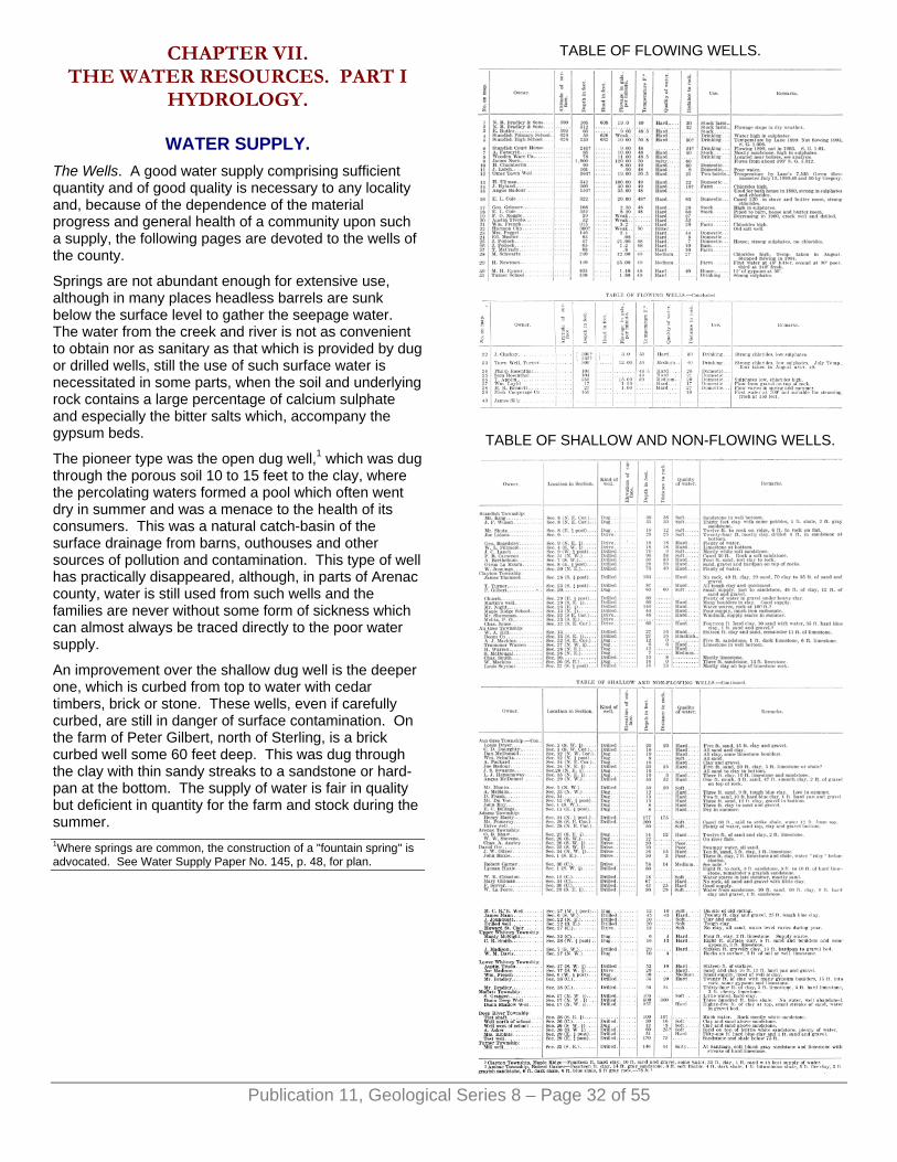
CHAPTER VII. THE WATER RESOURCES. PART I
HYDROLOGY.
WATER SUPPLY. The Wells. A good water supply comprising sufficient quantity and of good quality is necessary to any locality and, because of the dependence of the material progress and general health of a community upon such a supply, the following pages are devoted to the wells of the county.
Springs are not abundant enough for extensive use, although in many places headless barrels are sunk below the surface level to gather the seepage water. The water from the creek and river is not as convenient to obtain nor as sanitary as that which is provided by dug or drilled wells, still the use of such surface water is necessitated in some parts, when the soil and underlying rock contains a large percentage of calcium sulphate and especially the bitter salts which, accompany the gypsum beds.
The pioneer type was the open dug well,1 which was dug through the porous soil 10 to 15 feet to the clay, where the percolating waters formed a pool which often went dry in summer and was a menace to the health of its consumers. This was a natural catch-basin of the surface drainage from barns, outhouses and other sources of pollution and contamination. This type of well has practically disappeared, although, in parts of Arenac county, water is still used from such wells and the families are never without some form of sickness which can almost always be traced directly to the poor water supply.
An improvement over the shallow dug well is the deeper one, which is curbed from top to water with cedar timbers, brick or stone. These wells, even if carefully curbed, are still in danger of surface contamination. On the farm of Peter Gilbert, north of Sterling, is a brick curbed well some 60 feet deep. This was dug through the clay with thin sandy streaks to a sandstone or hard-pan at the bottom. The supply of water is fair in quality but deficient in quantity for the farm and stock during the summer.
TABLE OF FLOWING WELLS.
TABLE OF SHALLOW AND NON-FLOWING WELLS.
1Where springs are common, the construction of a "fountain spring'' is advocated. See Water Supply Paper No. 145, p. 48, for plan.
Publication 11, Geological Series 8 – Page 32 of 55

The dug wells which are curbed with sewer pipe, carefully cemented, and obtain water from only the lower layers, afford a good supply, as may be seen in many wells about Au Gres and a few at Standish, but such wells cannot be made very deep unless a crock of large diameter is used and then the expense is considerable. The wells having narrow crocks are generally made 10 to 15 feet deep, and in the bottom an opening to the lower water bed is drilled or bored so that if there is sufficient head the water will rise and fill the lower part of the well. This is not always a reliable source for a drinking supply as surface contamination is easy by seepage from above and through the joints of the crocks and also the quantity is frequently insufficient for stock purposes during the summer months. The large crock wells have considerable deposits of iron carbonates and other salts which effect the quality of the water. The vegetable growth of the various algae in the standing water often renders it unfit for stock purposes.
The bored and driven well is the most common throughout the county, while there are a large number of drilled wells in which the bedrock has been penetrated. Wells made by these methods are practically free from surface contamination, although a few cases are known where cesspools have polluted water of deep driven wells. Covered drains and cesspools are especially apt to contaminate shallow driven wells because the sewage, house waste and barn refuse is not exposed to the few upper feet of the soil which contains the nitrifying organisms which destroy some of the impurities. Cases of typhoid fever have been traced to wells of this construction, but this disease is moist frequently associated with dug wells.
Publication 11, Geological Series 8 – Page 33 of 55
The manner of constructing the more modern wells now depends upon the formation of the locality. In the pioneer days, the spring pole, a small derrick for pipe driving and a sandpump meet nearly all the requirements for making all classes of driven or drilled wells. In the sandy districts, a pipe with a point may be driven with a heavy maul, while, in the heavy boulder clay, boring or drilling is necessary, and in rockwork, horse-power or steam is cheaper and more effective than the old spring pole. In the common driven wells in unconsolidated material, such as sand or gravel, a 2-inch galvanized iron pipe is used and fitted with a point of brass whose meshes vary with the character of the formation.
Mr. T. Hughes, who has made a large number of the common wells, varying in depth from 80 to 100 feet, in the eastern part of the county, has used with success a light horse-power outfit consisting of a small two-timber derrick for raising two lengths of pipe, a section of heavy drive pipe, drive head, shoe, driver or hammer, revolving
water swivel, and a collection of light and heavy hollow drillrods and points of various kinds. The start is made by driving a length of pipe and then inserting the hollow drillrod which is rotated and used for cutting the material. In this outfit the water is poured in the pipe outside of the drillrod, which is "churned" up and down, forcing the water, charged with sand, up the rod and out at the surface through the water swivel. In drift work, this outfit operated in the above manner does excellent service and the average price of construction is about 50 cents per foot. In parts of the county where the formations are suitable, the contract is most frequently made for a flow or a well that will yield a certain amount under pumping. A similar outfit is fairly well adapted for well drilling in the sedimentary rocks of the county, if fitted with a larger assortment of stronger and heavier tools and more motive power.
Within the last few years, a few small "jetting" machines have been working in the county. These machines force water through the water swivel and down the rod, out of the drill point in the bottom of the well, and rising inside of the casing bring sand and pulverized rock to the surface, and, as the material is carried away from the bottom, the casing sinks into place. This method is not fully successful, but combined with driving and "churning," rapid and satisfactory work has been accomplished.1a
1aFor methods of well drilling consult Water Supply Paper No. 257. For many practical suggestions relating to the use and conservation or underground waters for farm use consult Water Supply Paper No. 255.
Quantity of the Water. The amount of water which a well yields depends upon the porosity of the formation, the amount of rainfall on the catchment area, and the head. If the country is flat and has a sandy loam soil, as the prairie land near Saganing, the ground water will stand high and only a few feet below the surface. In such locations an abundant supply of water will be found, sufficient for all small pump wells. In the clay land on the borders of the East Branch of the Au Gres river, the ground water stands even higher, and a carefully planned system of county drains is needed to reduce the level of the ground water and care for the spring floods. The opening and clearing of this river has been brought before the state legislature and an appropriation asked to aid this much needed work, but as yet the movement has met with little success. The swamp land north of Duck Lake on the western branch of the Au Gres river would be excellent land if reclaimed by proper drainage; some of it has a soil equal to the truck gardens land in the state. One appropriation for this purpose was made some years ago, but it was too small to produce any lasting results. Drainage lines in the Au Gres swamp would lower the general ground water level, and allow the large drains in Turner, Au Gres and Whiteny townships to better care for the water which accumulates in such quantities on the clay flats during the spring and after the heavy rains of the summer. The spring floods are especially troublesome to the farmers at Santiago and at the village of Au Gres, where the river often overflows for several weeks. In the latter place, on the
Publication 11, Geological Series 8 – Page 34 of 55
east bank of the river, the ground water stands from one to two feet below the surface most of the year and most of the shallow dug wells of this village draw their supply from this source.
Water always stands higher in fine material than in the coarser sediments. This is well illustrated along the old beach lines which are located west of the road between Pine river and Worth. In an examination of the wells at practically the same level along these beach lines, at the places where the material is coarse, the supply is much lower than where the material is fine sand. In a drive along the road on the west side of Sec. 18, in Standish township, one will pass alternately from the low, level, clay land which was formerly the lake bottom, up to the higher level sandy land which was the lake shore. Many springs are found along the edge of the sandy land and the clay land furnishes abundant moisture for the growth of crops, while the sandy lands some 15 feet higher and having the same rainfall support only a few of the familiar wild plants and shrubs. Farmers often find the sandy terrace a good location for a house because of its excellent drainage, but the well or spring is always below on the clay land where the water level is constant and near the surface.
The higher morainal land, about Maple Ridge, Culver and Alger, consisting of boulder clay, does not yield water readily. The lack of porosity in such compact soils renders them nearly impervious and ground water does not percolate through them. The wells of the Michigan Central Railroad at Alger, Mr. Chas. Jones of Maple Ridge, several at Sterling and Mr. John Dunn at Culver are deep in the clay and yield little water. In these regions, shallow wells with a surface supply are the best obtainable and are generally resorted to after failure to get water at some considerable depth in the drift, but water might be obtained by going deeper to the Napoleon sandstone.
The sand plains of the county northwest of Omer and north of Sterling are composed of unconsolidated material which is very porous and through which the water rapidly percolates. The water which reaches the underlying clays very soon reappears as large springs above the outcropping clays. The springs at the foot of Pinnacle Hill have this origin and numerous other springs of this kind are located along the Rifle river where it has cut into the clay overlain by sandy soil. The sandy plains are dry at the surface, even after a heavy rain, for the water soaks quickly into the soil and never gathers in rivulets or creeks. Wells dug through the sand to the clay often reveal the flowage of the ground water in a direction opposite to the slope of the sandy surface. Such supplies are quite uniform in their quantity, and, according to Mr. Franks, who lives near Pinnacle Hill, the water level is low early in the spring and higher during the summer months.
Rock Wells. The greater number of wells in this county are rock wells, because the water of the drift is often scarce, of poor quality, and, especially in the region of the outcropping Michigan Series, is apt to be unfitted for
use from the bitter salts originating from the underlying gypsum. Of the different rock formations, the white sandstone (the Marshall or Napoleon) yields the greatest supply of water both in the flowing and pump wells. All of the deep flows about Turner, Omer and Au Gres are from this sandstone. The very friable sandstones of the Saginaw Coal Series about Standish and Saganing yield much water which is sweetish and apt to blacken kettles.
Flowing Wells. In a number of the northern counties of the Lower Peninsula, the geological conditions are such that artesian or flowing wells result when the formations are penetrated in drilling or boring. The wells naturally arrange themselves in two classes, drift wells, or those drawing their supply from the glacial drift or Pleistocene deposits, and the rock wells, those in the various rock formations. In Arenac county, the rock flowing wells greatly outnumber the drift flows, while in the adjoining counties of Iosco and Ogemaw, the drift wells are the only flows. This does not mean that rock flows cannot be obtained in the two latter counties, but that the drift supply is found near the surface, is less expensive, and consequently the most utilized. The flowing wells are a valuable source of water supply and are much desired because of their almost never failing yield and small operative expense. The drift wells are very numerous in places throughout the state; some of the regions2 are at Harbor Springs and Oden in Emmet county, at West Branch and Rose City in Ogemaw county and at Tawas City in Iosco. The rock wells of Arenac which flow are widely distributed over the county which is in marked contrast to the concentrated location of the drift wells at Rose City, West Branch or Tawas City.
The drilling of brine wells for salt manufacture in this region in the days when lumbering was at its height and fuel was cheap led to the discovery of the fresh water flows and even some of the brine wells have been known to flow. The earliest drilling for the salt brine in the county was in Standish, Harmon City and Au Gres, and some of these wells are still in existence, and, when seen in 1903 were flowing, but the brine water had been cut off. The main reason for an increase in number of the flowing wells in this county is that the ordinary shallow wells did not give sufficient supply and hence the flows obtained by drilling into the rock have gradually increased in number about Au Gres and Standish, while new districts have been developed at Twining, Turner and Saganing.
The strongest flows of the county are from the underlying Napoleon sandstone and the strongest flow is from the well of James Norn at Standish which was drilled originally much deeper for brine. Its flow, when seen in 1901, was from sandstone. Mr. Angus BaDour of Au Gres, Mr. T. Applin north of Turner, and the Turner Town all own strong flows. The greatest flowage of any of the rock wells in the county is about 120 gallons per minute, from the Norn well at Standish, and many wells throughout the county average 20 to 30 gallons per minute. It would be natural to expect greater flowage from the rock than the drift, for the casing can be fitted

Publication 11, Geological Series 8 – Page 35 of 55
tighter and there is less chance for waste or leakage. Still, in spite of this, in the districts of Rose City and Williamsburg, the flowage of many wells is much greater than from any of the Arenac wells. The rock wells of this county do not have the pressure or flowage of those in the neighboring states of Wisconsin or South Dakota.
The geological conditions which are necessary for the production of flows are varied and have been investigated by many writers. The general laws governing flows were first formulated by Prof. T. C. Chamberlin.3
In a flowing well region, a pervious or porous water bed is necessary to permit the free entrance and circulation of the water. This water yielding layer or "waterbed" may consist of unconsolidated sands and gravel of the glacial drift which is the surface covering of the bedrock in this county, or it may be the solid rock, as a porous sandstone, like the Napoleon of this region. The upper white sandstone, the Napoleon of the Marshall, is an abundant yielder of fresh water wherever it is reached throughout the county, and the Lower Marshall is abundant in brine which sometimes flows to the surface. A thin bed of limestone may be so fractured and dissolved along the joints and fissures that it affords an easy passage for water.
An impervious layer above the water bearing bed is essential to prevent the escape of water upward. Many of the early investigators considered an impervious layer below the water layers necessary to produce a flow, but this has been found unnecessary.4 The Maxville limestone and gypsum beds of the Michigan Series form the impervious bed above the Napoleon. The arrangement of the gypsum beds, Maxville limestone and the sandstones of the latter series is often such that small flows are to be found above those of the Marshall; thus in drilling deep wells several flows may be encountered. The water from the Michigan Series, having a higher content of the earthy salts, is easily distinguished from the fresher water of the Upper Marshall sandstone with its small amount of sodium chloride.
The alternating arrangement of water beds and impervious capping would be useless unless the water beds are inclined so that the porous water layers outcrop to receive rainfall at some elevation higher than the surface on which the well is located. This inclining of the various layers creates a pressure at the mouth of the well. In the case of deep flowing wells in Arenac county, which are supplied from Marshall sandstone, an inspection of the geological map on Plate I shows that the outcrops of the various formations extend across the county roughly northwest and southeast, dipping gently to the southwest. (See Fig. 4 for cross section). The Saginaw Coal measures are along the southern edge, the Upper Grand Rapids, or Maxville limestone, near the center, the Lower Grand Rapids near the northern part of the county and extending into the southwest part of Iosco county. The Marshall sandstone appears from well records to be near the surface throughout the center
of Iosco county, beneath which is the St. Clair formation. The rocks all dip or incline about 20 feet per mile to the southwest in the direction of Saginaw (or Midland) which is the geological center about which all the outcrops are arranged concentrically. The gathering ground of the Marshall sandstone is evidently in the porous drift on the high land in Iosco, Ogemaw and Midland counties. The water will thus be under considerable pressure when tapped by wells in Arenac county. Wells receiving their supply from the Marshall sandstone are common in Huron county and other counties of the state. In the former place, their supply at certain points is known to vary with the variation of rainfall upon the outcrops.5
The flowing wells from the Marshall of Arenac do not exhibit any fluctuations which have been detected since drilling, and some of these were made over 20 years ago. This is probably due to the great area of sandstone exposed under the porous drift, which quickly absorbs all rainfall and constitutes a great storage reservoir. The flowage from the shallow wells about Twining and Standish has varied considerably in the past five years. 2Water Supply Paper No. 183. Different areas are discussed. 3The Requisite and Qualifying Conditions of Artesian Wells. Fifth annual report of the U. S. Geological Survey, pages 133-173. 4In fact flows can be produced on a steep bluff by the different degrees of packing of the sandy layers. See Water Supply Paper No. 145, pp. 41-42. The terms artesian, flowing well, artesian basin, etc., are discussed in Water Supply Paper No. 160, p. 14. 5Geology of Huron County, Vol. VII, part 2, p. 119.
The Flowage and the Pressure. The height to which water will rise in a pipe or above the well mouth depends in theory upon the elevation of the catchment basin above the well mouth, but in actual practice, because of the great loss of force by friction, the water does not rise as high in the fountain as its source.6 For every foot that water rises in an open pipe above the well mouth, there can be counted .43 pounds of pressure, or 1 pound of pressure if required to lift water 2.31 feet. The greatest pressure of any well in the county was at Standish, but at Turner in the town well there is about 10 pounds to the square inch. The pressures are never great and throughout the county average less than 3 pounds to the square inch.
The flowage of a well depends upon the porosity of the formation and somewhat upon the methods employed in its construction. After drilling to the water bed the yield may be considerably increased by dynamiting at the bottom of the pipe and also strong pumping will often form a channel which allows the water to gather more readily. The flowage of all the wells in the county has been carefully measured by timing the interval required by each flow to fill a vessel of known capacity or by the use of some of the simple hydraulic tables which have been prepared by Todd with additions made by Slichter7 The drillers often take a contract to make a flow with a capacity of a certain number of gallons per hour and the use of such tables is often convenient.

Publication 11, Geological Series 8 – Page 36 of 55
The supply from all of these wells is amply sufficient to meet the demands of those in the villages and on the farms. In many places throughout the county hardly a tenth of the water is used. Fluctuations of flowage in the deeper wells in the Marshall sandstone has not been observed since drilling. A marked decrease has taken place in many of the wells in the Michigan Series at Twining and at Standish. Some observers interested in the Twining wells considered that this change is due to decrease in rainfall. There is a greater chance at present for rainfall to become run off because of the lumbering operations which have cleared away the forest litter and opened up the rivers.8 The failure of wells at Standish may be due to the operation of many coal mines at Bay City and Saginaw which exert some influence by lowering the general water level in the rock layers. In Twining there is no doubt but that there is a close relation to rainfall and the flowage as some of the records have shown. 6Loss of head about one foot in every mile of distance that the water circulates from the source. Cooper. 7Water Supply Paper No. 110, U. S. Geol. Survey. C. S. Slichter. pp. 37-42. 8See paper by M. L. Fuller, annual report for 1904, Mich. Geo. Surv.
Quality of the Water. In this region an abundance of water does not always mean that it is suitable for use, for it frequently happens that so much mineral matter is carried in solution that the waters are unfit for manufacturing purposes, farm or general domestic use. The minerals which are commonly in solution in the waters of this county are calcium, both the sulphate and the carbonate, salt or sodium chloride, carbonate and sulphate of magnesium, carbonic acid gas, and iron. The presence in moderation of any or all of these ingredients does not effect the quality of the water, in fact, in drinking water it is considered quite necessary to have certain salts present, but it is the excess of any of these elements that renders the water unpotable.
The most common defect in the quality of the water which is easily recognized is that of "hardness." Those living where the bedrock is limestone and gypsum have observed that the water is temporarily and sometimes permanently hard respectively as it is drawn from the former or the latter formation. Temporary hardness is due to the presence in solution of limestone or calcium corbonate and is softened by boiling in which process the lime is deposited as a scale in the tea kettle. This scale effervesces easily in strong vinegar, and if it has a red or pinkish color it indicates the presence of iron. The hardness of water is better known in another manner from its reaction with soap, as a good lather is not easily formed in the presence of the above salts in solution. The soap in hard water tends to accumulate in flecky patches, making an insoluble "curd" rather than spreading uniformly through the liquid. Permanent hardness of the water in this region is due principally to the presence of gypsum (calcium sulphate) in solution, and this is not removed by boiling but may be detected by attempting to make a lather with the boiled water.
Water of this character is supplied by many of the wells about Turner and Twining, where it is quite troublesome in cooking or for laundry purposes. Some cases have been observed where vegetables of various kinds could not be properly cooked by boiling unless the water was softened by adding soda. In the laundry work the hard water requires two-thirds more soap than is necessary when soft water is used. The use of such water is wasteful and harmful and it can always be softened by adding carbonate of soda. Various alkali washing compounds as well as some of the strong alkali soaps are much in demand where the water is gypsiferous. The magnesium salts have a reaction similar to the calcium salts, but they are difficult to detect in ordinary field analysis.
Flowing well water may have a high percentage of sodium chloride and give the familiar "salty" taste like much of the water from deep wells about Turner. The saline content may be of sufficient quantity for the manufacture of salt, as has been done at East Tawas and as was attempted at Standish and Harmon City. Such waters are unsatisfactory for steaming as they cause foaming and are apt in time to corrode the boiler. The "bitter" water often found on top of the gypsum in this region is due to the presence of the chlorides of magnesium and calcium, and it corres-sponds to the "'bittern" or mother liquor that is left in taking the salt from the brine. Slightly saline water is eagerly sought by stock and some of the old deer licks in the county were salty springs. Many people who drink saline water find that a smaller amount of it is necessary to quench the thirst than fresh water. The saline water which is also high in sulphates often acts as a cathartic and Dr. Gregg of Standish has for years recommended such a water from the James Norn well for various hepathic troubles. The water from the abandoned well at Harmon City is very bitter and violent purging it apt to accompany the use of it. An odor of H2S gas about the well would indicate that this water is from the same geological horizon as that of the former brine wells at Tawas City, which are five miles to the north on Tawas Bay. In many flowing wells it is found that the tinware rusts very rapidly owing to the presence of the free carbonic acid gas which in solution gives a mild acid reaction to the water. The acid gives the water a pleasant, tart taste and is considered by many physicians to be especially beneficial to dyspeptic people. A slight amount of iron in some of the water makes it chalybeate as in the wells about Au Gres. There are many simple tests for the different elements contained in water, and these methods have been fully and amply discussed in the report on Huron county.9 It is a necessary and important duty to see that the water supply is pure, wholesome and uncontaminated. Frequent inquiry should be made regarding the source of supply and the quality of the water; especially during the summer at the time of low water is this most necessary, as then the danger from typhoid fever is the greatest and if the contamination is suspected the water must be boiled.

Publication 11, Geological Series 8 – Page 37 of 55
The water from the flowing wells of this county may be soft, high in sulphates and carbonates, or a strongly saline water. The character of the water depends upon the geological formation from which it is drawn. A well in the Michigan Series almost always gives a "hard" water, or one high in sulphates, and even plenty of chlorides are frequently present as in the shallow flows about Turner and Twining. The well of Sam. Rosenthal (No. 35) at Turner is high in sulphates and chlorides and the flow was obtained at a depth of 104 feet below the surface. The record of this well reveals the limestone, the gray blue sandstone and the gypsum which m characteristic of the Lower Grand Rapids of the Michigan Series. At Twining there are many similar wells and these have shown within the last few years a general decrease in flowage. This rather indicates that their catchment area is somewhat and possibly entirely separate from that of the wells at Turner which have not decreased. In the white sandstone of the Napoleon, just beneath the Michigan Series, an abundant supply of fresh water under a strong head is often found, while still deeper in the Marshall sandstone is the brine water. Thus the water from wells of different depths in the same locality varies in its quality as well as quantity. This is illustrated at Turner, Au Gres, and Standish, where the deeper wells in the Napoleon sandstone yield a relatively fresh water while the shallow derive their supply from the Michigan Series and yield a water high in sulphates. 9See also Field Assay of Water, United States Geological Survey, Water Supply Paper 151.
Well Temperatures. The temperature of flowing well water varies only a degree or two during the year. It never freezes during the winter and in the warm days of summer it is especially suitable for drinking and general domestic purposes. The similarity of the temperature of spring water and the mean annual air temperature of the locality has often been observed throughout the county. In the large spring on the Rifle river at the foot of Pinnacle Hill the average temperature of 46° for the water is higher than the mean annual air temperature of 43.1°, which is the average of this region taken from the Omer records. The spring water in this case receives its temperature from the loose, porous, sandy soil 30 to 40 feet in thickness. Taking the temperature of the spring water the same as that of the soil, this makes the difference between the soil and the air temperature about three degrees, exactly 2.9°. Comparing this difference between the soil and the air temperatures with the results obtained by a series of experiments carried on for a number of years at the University of Toronto10 it seems as if this difference was too small. In the Toronto experiments the average annual earth temperature for the soil at the depth of 9 feet is 42.2° and the average air temperature is 4.07° less.
Dr. A. C. Lane has called general attention to earth temperatures in several articles.11 The temperature gradients for many of the deep wells of the state have been investigated and the difference of from 1 to 4
degrees proposed as the proper relations between the air and the soil temperatures.
So many records and temperatures of shallow flowing wells have been collected in this work that an attempt is made to determine some of the gradient values for wells less than 500 feet in depth. This has been done in the appended notes by the observations of all the wells in the area, and using the average of temperature and depths to obtain the gradient. For example, take the case of wells 30 to 50 feet in depth inclusive. The number of such flows is 8, the average depth is 37, and the average temperature is 47°, thus the gradient is (assuming 46° as the initial or earth temperature, 47°—46°=1°, 37'÷1=37') 1 degree for 37 feet.
Wells 20 to 30 feet inclusive 1 degree for 13.9 feet.Wells 30 to 50 feet inclusive 1 degree for 37 feet.Wells 50 to 75 feet inclusive 1 degree for 25 feet.Wells 75 to 100 feet inclusive 1 degree for 14 feet.Wells 100 to 200 feet inclusive 1 degree for 58 feet.Wells 200 to 360 feet inclusive 1 degree for 91 feet.Wells 20 to 70 feet average one degree for 20 feet, assuming the same ground temperature has been taken in the above calculations. 10Royal Society of Canada, Section III, 1901. Soil Temperature by Callendar and MacLeod, University of Toronto. 11Annual report of the Geological Survey for 1901, page 244.
The Uses. The flowing well water, when it can be obtained, is to be preferred to the surface or shallow well water because there is less danger from organic contamination and the supply is more reliable. The first expense of a flowing well is often so much as to prevent its general use. The wells are most frequently bored or drilled by contract at 50 to 80 cents per foot, and for a well 200 feet in depth the cost varies from $120 to $160. The rock wells do not require much expense for a number of years after completion. Some of the wells require frequent cleaning of the mineral deposits which accumulate as a hard crust inside the pipe, but sand pumping is about all the extra expense that many of the wells have required for years. For drinking purposes, the water is excellent, except where it is high in chlorides, sulphates or carbonates. The very hard water has been considered the cause of some of the common kidney diseases and the local physicians find more than the usual number of cases of calculi which is due to the high percentage of insoluble mineral salts in the water. Sulphates seem to be especially beneficial in stomach troubles, while the chlorides in combination with the various forms of calcium apparently act on the liver. The James Norn well at Standish gives a water high in chlorides. It is strongly cathartic to those not accustomed to its use and has been quite frequently prescribed by local physicians and it has been occasionally shipped to Bay City and Saginaw. In the water from a well belonging to Angus BaDour at Au Gres, enough iron is present to make it slightly chalybeate. This water was once considered to be

beneficial in the treatment of various skin diseases, and a small bath house was erected here a number of years ago and later abandoned.
The presence of water in such abundance and of the quality which is obtained at Turner, Standish and about Au Gres ought to lead to the establishment of some trade in bottled goods. The demand at present is large for mineral waters and also pure water as the base of summer beverages. It would cost little to equip some of the wells with a bottling apparatus and, with a carbonating engine, a product could be supplied to the trade equal in purity to many of the popular bottled waters that sell so extensively on the market. At Topinabee, Michigan, the drift water is bottled, some being carbonated and fancy summer drinks produced. The marketing of this water and the products yields a good income each year for the proprietors. In brewing, the sulphates and the carbonates are considered beneficial rather than harmful; at the West Branch brewery, gypsum is used to give the beer a flavor that can not be obtained from the drift water.
The temperature of the water in this county ranges from 46° to 50° which is a good temperature for drinking, being plenty cool enough to be palatable and not having the harmful effects produced by ice water. The water is most useful in the cooling of milk and for general dairy purposes on the farms. Wherever flows have been obtained a milk house is easily constructed with tanks in which 10-gallon milk cans are almost covered by the running water, keeping the milk at a temperature of 49° to 50°. Inspection of the milk laws of many of the large cities reveals that this is exactly the temperature at which milk must be kept before delivery, the reason being that under these conditions there is practically no growth of pathogenic germs, which multiply so rapidly in warm milk and are the source of the great infant fatality during the warm weather in our large cities. On the farm of Mr. E. G. Cole, a model milk house has been constructed which cares for the product of a large herd. Mr. F. L, Twining, a produce dealer at Twining, has a carefully constructed butter room cooled by flowing well water and he considers it superior to ice cooled storage. In cheese making, both the mineral constituents and the temperature of flowing well water have been found very satisfactory.
FLOWING WELLS AT TWINING AND TURNER.
General Relations. The number of people depending upon the flowing wells of Turner and Twining for their water supply is sufficient reason for making a special discussion of the conditions of this locality. In 1904, the writer spent a short time at Twining and the conditions are reported in Water Supply Paper No. 183.
The map Fig. 18 shows some of the wells in the vicinity of Twining and Turner and the tables give a definite statement as to flowage, depth and quality of water. In both of these towns, the wells are in the rock which is covered with 12 to 20 feet of drift, consisting largely of
clay with boulders of limestone and gypsum, the latter being derived from the Michigan Series which is the bedrock of the region.
Present Developments. About 30 wells have been made in Twining in the last 12 years and at Turner there are 16 wells. The wells were drilled primarily because many of the shallow ones yielded a water which was bitter and unfit for stock purposes or domestic use. The wells when drilled rarely failed to flow and many of them have a strong head of water. The cost of drilling is moderate, averaging about seventy-five cents a foot. The wells are quite frequently clogged by deposits of the sulphates which occur on the inside of the pipe and in some cases the pipe has been eaten by the presence of carbonic acid gas in the water. All of the wells require repiping and cleaning about once in three years. The wells are allowed to flow freely, but it is unnecessary waste and lowers the general head of the ground water. The deeper wells are all cased down to the rock, which shuts off the surface water. Several of the shallow wells have the pipe extending only a few feet into the rock, and water is drawn from a drill hole in the bottom of which a charge of dynamite has been exploded. This last method of obtaining water frequently destroys the flows of several of the neighboring wells.
Fig. 18.—Flowing wells of Twining.
Flowage. The flowage of the different wells was measured carefully so that in the future it will be easy to determine whether the yield from a well has decreased or increased. In Twining 21 wells flowed 52.2 gallons a minute, the largest flow being 25 gallons a minute from a
Publication 11, Geological Series 8 – Page 38 of 55
Publication 11, Geological Series 8 – Page 39 of 55
well (No. 6 of the table) on the mill property of T. MacCrady. The flowage of some of the wells varies at different times of the year. For instance Mr. T. Reade's well (No. 14) ceased to flow during a drought in July and August, 1904, while at the time of the writer's visit which was four days after the close of a week of heavy rainfall, there was a flowage of .8 gallons a minute from this well. Mr. F. L. Twining had the same experience with a well (No. 5) which flows much stronger in the spring and late in the fall and shows a noticeable increase several days after a period of prolonged rain. In July, 1903, Mr. Twining's well at the store (No. 5) flowed 10 gallons a minute, while in 1904 during the same month its flowage was very small and a pump was required. A number of other wells have shown a tendency to decrease. At the Hotel Normal in July, 1903, the well had a flowage of 3 gallons a minute, while in the same month of 1904 the water level was 2 feet below the mouth. Several of the wells have a common supply as shown by the decrease in flowage of wells No. 2, 3, and 5, when in May, 1903, well No. 6 was allowed to flow for three days. Mr. Geo. Dillon's well in July, 1903, flowed nearly 10 gallons a minute but, during the same month of 1904, the flowage was very small and varied from day to day, and according to those who observed the well carefully, its variations depended upon the rainfall. The flowage differs somewhat with the character of the rock in which the well is drilled. If it is largely sandstone the supply is more uniform than where the beds contain considerable gypsum. The 16 wells in the vicinity of Turner have a combined flowage of 98 gallons a minute and the largest flow is from well (No. 29) Mr. H. Newman. The wells which have been recently drilled have the greatest flow. The town well (No. 33) had the greatest yield when it was first drilled and it gradually decreased until it was cleaned. The Swartz well (No. 28) which flowed 12 gallons a minute in 1903, was clogged and did not flow in the summer of 1904. It was found that a considerable deposit of calcium carbonate had filled the inside of the pipe. In December, 1906,12 Mr. S. Cook tried drilling for a well 80 rods north of the Twining Post Office and reached a water-bed under considerable pressure and this well has drained all of those starred on the table of wells for Twining.
The wells at Turner are all of a greater depth than those at Twining, and they have not shown the general decrease in supply which has been found to be gradually taking place at Twining.
The Water-beds at Twining. The flows at Twining are all in the sandstone and limestone of the Lower Grand Rapids. In some outcrops of the bedded limestone and sandstones of this series at the old Glendon Dam in Iosco county, the soft layers are seen to be dissolved and channeled out by the action of the underground water, making a very porous rock. Many springs in that region have a supply from porous rock originating in this manner. This same condition has been observed in the Lower Grand Rapids at testpits east of Turner and west of Twining. In drilling through this series to the Marshall, it is often necessary to case off this water which under
some head is distributed over a large district and at Twining all of the wells are from this porous rock of the Grand Rapids series. It may be that this water is derived from a supply seeping through the drift on the catchment basin or it may be possible that its source is from the water working to the surface from the Marshall sandstone.
In Turner the shallow wells of M. Eymer, Sam. Rosenthal, and Philip Rosenthal, are high in sulphates, and derive their supply from a sandstone bed near the bottom of the Lower Grand Rapids, which is 104 to 110 feet below the surface. The deeper wells of this place, all reach the Napoleon sandstone which supplies water under a stronger head with less sulphates and chlorides than the shallow wells. The Turner school house well (No. 31) is 130 feet deep, is evidently in the white sandstone of the Grand Rapids, while the 300 foot town well (No. 33) draws its supply from the Napoleon sandstone but deeper in it at 191 feet, and further drilling in the latter well to 300 feet did not increase the flowage, but gave less water, higher somewhat in chlorides. Mr. Clucky's well, east of the village in section 17, has the same supply at 191 feet and the Swartz well, at higher elevation, in Section 9, northeast of the village, penetrates the same white sandstone at a depth of 240 feet and the supply is not as abundant as could be obtained by drilling a few feet farther. A strong flow was obtained at 253 feet in the well of T. Applin, in Iosco county in Section 31, T. 21, R. 6 E. The Napoleon here is reached at 220 feet below the surface. Records of several wells of this region show that several water beds which yield flows are often penetrated in drilling. For instance in Mr. H. Newman's well (No. 29) southeast of Turner, at 48 feet a bitter flow was found, at 90 feet the water was high in sulphates, while at 140 feet in the Napoleon the water is less hard, higher in chlorides and considered a comparatively fresh water.
Quality of Water. The shallow wells which are deep enough to meet ordinary domestic needs, furnish water high in sulphates and. carbonates but it is often quite bitter when the well is near the top of the rock. Of the wells which flow from the rock, the water highest in sulphates and corbonates comes from wells No. 1 and No. 9. In the latter the water was mixed with surface water for use in steaming but has been discarded because of trouble with boiler scale. In Mr. J. W. Jaynes' (No. 15), the water is so soft that it is used for laundry purposes without addition of the softening compounds that are necessary with much of the water in this region. 12A letter from Mr. F. L. Twining to the writer.

PART II.—THE HYDROGRAPHY.
WATER-POWER. The Rifle River. The chief river for power purposes in the county is the Rifle, which has its head waters near the towns of Lupton, Rose City, and West Branch in Ogemaw county. The headwaters are in a heavy clay region which has an average elevation of 376 feet above Lake Huron. The river enters Arenac county 4 miles northwest of Alger and flows south to Deep River township where it turns eastward for the length of the township and then southeast entering Saginaw Bay near the center of Section 4, R. 6 E. and township 18 N. The largest lakes in the Rifle basin are:
Peach Lake, in 22N., R. 2 E., sec. 15. Clear Lake, in 23 N, R. 1 E., sec. 26. Horse Shoe Lake, in 23 N., R. 1 E., sec. 25. Sages Lake, in 23 N., R. 4 E., sec. 31. Bush Lake, in 21 N., R. 3 E., sec. 26. Devoe Lake, in 23 N., R. 3 E., sec. 12.
None of these lakes are large enough to be useful as storage reservoirs as they are too near the source of the river. The basin of the Rifle river is about 400 square miles. It is long and narrow, the soil consists generally of the rather porous Pleistocene deposits. The
tributaries are the most numerous on the clay land and there are practically no branches on the sandy plains. This is nicely illustrated on this river in Arenac county, where no branches are derived from the sand plains south of the streams, while to the north of the Rifle, on clay land, there are many surface streams. In general, the volume of surface water to the Rifle river is low, and it is supplied largely by underground water. The stream is not subject to violent fluctuations in the volume, which is characteristic of streams in a rock basin, and during the summer droughts, it has a fair volume which is derived from the sweepage waters of the sandy soil.
A general reconnaissance of the river was made by the writer in 1900 and the elevations were obtained at the time by the aneroid barometer, and since that time, because of the increasing importance of waterpower of this river, Mr. J. H. McFarlan has made a series of spirit levels along the river. These are given below through the kindness of Mr. McFarlan:
There is a bench mark on elm on south side of river just above Meeker's bridge consisting of two 8 d. nails driven in a tree 6.48 feet above the water and 2.55 feet from the ground. Water at M'eeker's bridge is 85.82 feet below tie at Michigan Central Railroad depot in Sterling. This survey was finished July 28, 1905, and all figures are at water's edge.
The above elevations by Mr. McFarlan are taken in a part of the river which will afford the most effective power. In this region the river flows meandering for miles between high clay bluffs which would render damming at many points comparatively easy and the depth of the valley would enable considerable ponding with small loss of land. In Ogemaw county, township 21 N., R. 3 E., Sec. 9, the Rifle river flows over sandstone ledges for more than a mile. The remains of an old lumber dam exists an eighth of a mile north of the West Branch iron bridge which is near the southeast corner of section 9. An effective working head of 10 feet could be utilized here, for the river bed is sandstone and the banks solid clay, and it would be possible to increase the head to at least 15 feet wide with an abundant supply of water.
The fall is about 30 feet from this bridge to Isle Rapids, which is a quarter of a mile west of the southeast corner
Publication 11, Geological Series 8 – Page 40 of 55
Publication 11, Geological Series 8 – Page 41 of 55
of section 28, township 21 N., R. 3 E. The rapids are a quarter of a mile long and are over ledges and beds of arenaceous limestone, the fall from the head to the foot of the rapids being nearly 6 feet. Where the abandoned Alger line of the Detroit and Mackinac railroad crosses the Rifle river in section 12, township 20 N., R. 3 E., the elevation of water level is 693' A. T.2
In township 19 N., R. 4 E., in the eastern part of section 3, the Pinnacle Hill dam was built by a lumber company for logging operations on the river. This dam is 250 feet long with the carbonaceous sandstone for foundation and the heavy clay banks. A head of about 15 feet is maintained by this dam during the year. Rapids occur over the bedrocks in several places between the Pinnacle Hill dam and Omer. There are some suitable sites for dams below the one at Pinnacle Hill. If a small dam and mill could be constructed near the northeast corner of section 1 of township 19 N., R. 4 E., it would have ample custom work from the region north of Melita and Maple Ridge.
The old Rifle river canal in the west half of sections 36 and 25 of township 19 N., R. 5 E., which extended from the river to Wigwam Bay is said to have had a fall of 15 feet in one and one-half miles. Mr. Cheeseborough, a prominent lumberman of early days, cut this canal for log driving. It was unsuccessful on account of the large amount of sand encountered.
Some of the larger creeks flowing into Rifle river could be utilized for small power. Wells creek,3 southeast of Alger, would afford sufficient supply for 10 horse-power. Silver creek and Mansfield creek would yield power on small scale. The West Branch of the Rifle river could be relied upon for at least two dams of 10-foot head and 75 to 100 feet in width. At West Branch there are two dams which furnish power for electric lights and a mill. The east branch of the Rifle river near the north line of township 22, R. 3 E., would provide some power.
The only place where the river is utilized is at Omer, where a dam gives ample power throughout the year for a flour and sawmill. The crest of the dam is 608' A. T. and the foot is 595' A. T. and the drainage area above the damage is 364 square miles. The foundations are the soft sandstone of the Saginaw Coal Series, and the pond area is rather narrow and long.
A gage station for the Rifle river was established at Omer, September 1, 1902, under the directions of Robert E. Horton,4 of the United States Geological Survey. It was located on the Detroit and Mackinac Railroad bridge, one-half mile below the dam in Omer village. The gage was read twice each day by Mr. Murchinson and on December 31st, 1903, was discontinued because of the shifting channel of the stream. The bridge has a span .of 109 feet. The bed is of sand and of fine drift. The channel is curved and does not pass beneath the bridge at right angles. The bed is rather stony on the concave and sandy on the convex side, with some old bridge piles and sunken log between. A temporary gaging station5 was established
November 14th, 1905, at Meeker's bridge near Sterling in Sec. 5, township 19 N., R. 5 E. Four discharge measurements have been made by Prof. J. B. Davis of the University of Michigan. 2This is an elevation obtained by spirit level and checks rather satisfactorily with Mr. McFarlan's elevation of 690.1 feet for this same location. 3Professor J. B. Davis estimated the flowage on September 3rd, 1905, at a point below Wells creek in section 21, Tp. 21 N., R. 3 E., to be 232 second feet. 4See Water Supply Papers, Nos. 129, p. 55, 83, p. 285, and 97, p. 433. 5Water Supply Paper No, 170, page 41. See also Water Supply Paper No. 206, page 380.
The Pine River. The Pine River, in Arenac county, while a small stream, has a fall of 44 feet between Standish and Saginaw Bay. A point near the southeast corner of Sec. 5, township 18 N., R. 5 E., where the Pine River receives its south branch, would supply power for a small industry, as a creamery. The water supply might fail during a part of the summer. At Deep River, on the Michigan Central, the north branch of the Pine River runs in a narrow valley, which affords an excellent location for a small dam with a working head of at least eight feet. On the Pine River at Standish, there was formerly a log boom, but it is not sufficient for power.
Saganing Creek. The Saganing Creek, in the southern part of Arenac county, has a small volume which would furnish several farms near Worth with power for a small feed mill a part of the year.
The au Gres River. The Au Gres River has a drainage area of 478 square miles in Arenac, Iosco and Ogemaw counties. It is fed by a large number of small tributaries and has a few small lakes in its basin. The river rises in Styles Lake. A dam on the outlet of this lake has a head of eight feet and could be easily increased. The bed of the river in its lower course is a clay hard-pan, while in its middle and upper courses is largely in the rock of the Michigan Series. The banks in the middle courses are high, composed of clay and covered with sand or gravel. Many spring creeks come into the river and the character of the underlying clay with its porous sandy covering makes this a very scaturiginous country. At the junction of Hope Creek and Au Gres River in Section 28, township 22 N., R. 5 E., there is an average depth of one and one-half feet of water and it is 20 feet wide. The banks are high and of solid clay. Much land would be flooded at this place by a dam which would have a working head of 10 feet. The river is 75 feet above Lake Huron at the Detroit and Mackinac Railroad bridge which is two miles east of Whittemore. In Sec. 18, township 21 N., R. 5 E., a lumber-dam was constructed and the location is an excellent one for a small mill requiring a 10-foot working head. The river has a fall of 30 feet between where the railroad crosses it east of Whittemore and the main line crossing north of Turner. It would not be possible to utilize the lower course of the Au Gres River for power, for the low banks and the level character of the land would allow too large an area to become waste and swamp.
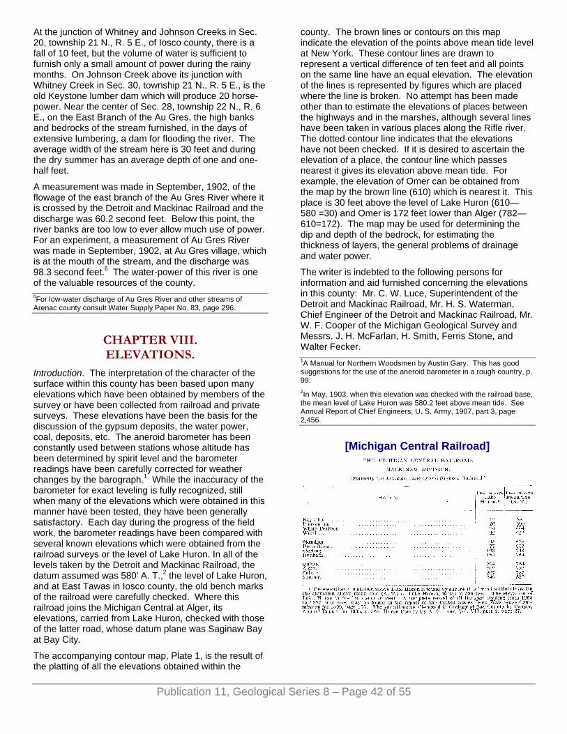
At the junction of Whitney and Johnson Creeks in Sec. 20, township 21 N., R. 5 E., of Iosco county, there is a fall of 10 feet, but the volume of water is sufficient to furnish only a small amount of power during the rainy months. On Johnson Creek above its junction with Whitney Creek in Sec. 30, township 21 N., R. 5 E., is the old Keystone lumber dam which will produce 20 horse-power. Near the center of Sec. 28, township 22 N., R. 6 E., on the East Branch of the Au Gres, the high banks and bedrocks of the stream furnished, in the days of extensive lumbering, a dam for flooding the river. The average width of the stream here is 30 feet and during the dry summer has an average depth of one and one-half feet.
A measurement was made in September, 1902, of the flowage of the east branch of the Au Gres River where it is crossed by the Detroit and Mackinac Railroad and the discharge was 60.2 second feet. Below this point, the river banks are too low to ever allow much use of power. For an experiment, a measurement of Au Gres River was made in September, 1902, at Au Gres village, which is at the mouth of the stream, and the discharge was 98.3 second feet.6 The water-power of this river is one of the valuable resources of the county.
Publication 11, Geological Series 8 – Page 42 of 55
6For low-water discharge of Au Gres River and other streams of Arenac county consult Water Supply Paper No. 83, page 296.
CHAPTER VIII. ELEVATIONS.
Introduction. The interpretation of the character of the surface within this county has been based upon many elevations which have been obtained by members of the survey or have been collected from railroad and private surveys. These elevations have been the basis for the discussion of the gypsum deposits, the water power, coal, deposits, etc. The aneroid barometer has been constantly used between stations whose altitude has been determined by spirit level and the barometer readings have been carefully corrected for weather changes by the barograph.1 While the inaccuracy of the barometer for exact leveling is fully recognized, still when many of the elevations which were obtained in this manner have been tested, they have been generally satisfactory. Each day during the progress of the field work, the barometer readings have been compared with several known elevations which were obtained from the railroad surveys or the level of Lake Huron. In all of the levels taken by the Detroit and Mackinac Railroad, the datum assumed was 580' A. T.,2 the level of Lake Huron, and at East Tawas in Iosco county, the old bench marks of the railroad were carefully checked. Where this railroad joins the Michigan Central at Alger, its elevations, carried from Lake Huron, checked with those of the latter road, whose datum plane was Saginaw Bay at Bay City.
The accompanying contour map, Plate 1, is the result of the platting of all the elevations obtained within the
county. The brown lines or contours on this map indicate the elevation of the points above mean tide level at New York. These contour lines are drawn to represent a vertical difference of ten feet and all points on the same line have an equal elevation. The elevation of the lines is represented by figures which are placed where the line is broken. No attempt has been made other than to estimate the elevations of places between the highways and in the marshes, although several lines have been taken in various places along the Rifle river. The dotted contour line indicates that the elevations have not been checked. If it is desired to ascertain the elevation of a place, the contour line which passes nearest it gives its elevation above mean tide. For example, the elevation of Omer can be obtained from the map by the brown line (610) which is nearest it. This place is 30 feet above the level of Lake Huron (610—580 =30) and Omer is 172 feet lower than Alger (782—610=172). The map may be used for determining the dip and depth of the bedrock, for estimating the thickness of layers, the general problems of drainage and water power.
The writer is indebted to the following persons for information and aid furnished concerning the elevations in this county: Mr. C. W. Luce, Superintendent of the Detroit and Mackinac Railroad, Mr. H. S. Waterman, Chief Engineer of the Detroit and Mackinac Railroad, Mr. W. F. Cooper of the Michigan Geological Survey and Messrs. J. H. McFarlan, H. Smith, Ferris Stone, and Walter Fecker. 1A Manual for Northern Woodsmen by Austin Gary. This has good suggestions for the use of the aneroid barometer in a rough country, p. 99. 2In May, 1903, when this elevation was checked with the railroad base, the mean level of Lake Huron was 580.2 feet above mean tide. See Annual Report of Chief Engineers, U. S. Army, 1907, part 3, page 2,456.
[Michigan Central Railroad]
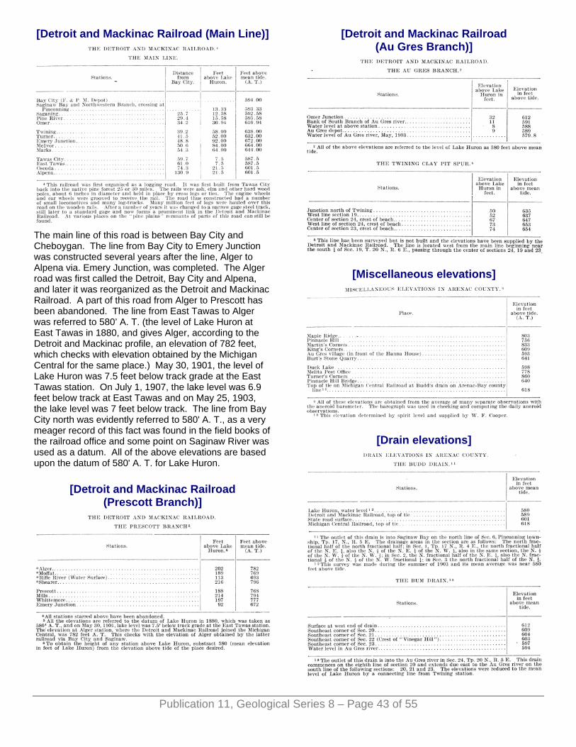
[Detroit and Mackinac Railroad (Main Line)]
The main line of this road is between Bay City and Cheboygan. The line from Bay City to Emery Junction was constructed several years after the line, Alger to Alpena via. Emery Junction, was completed. The Alger road was first called the Detroit, Bay City and Alpena, and later it was reorganized as the Detroit and Mackinac Railroad. A part of this road from Alger to Prescott has been abandoned. The line from East Tawas to Alger was referred to 580’ A. T. (the level of Lake Huron at East Tawas in 1880, and gives Alger, according to the Detroit and Mackinac profile, an elevation of 782 feet, which checks with elevation obtained by the Michigan Central for the same place.) May 30, 1901, the level of Lake Huron was 7.5 feet below track grade at the East Tawas station. On July 1, 1907, the lake level was 6.9 feet below track at East Tawas and on May 25, 1903, the lake level was 7 feet below track. The line from Bay City north was evidently referred to 580' A. T., as a very meager record of this fact was found in the field books of the railroad office and some point on Saginaw River was used as a datum. All of the above elevations are based upon the datum of 580' A. T. for Lake Huron.
[Detroit and Mackinac Railroad (Prescott Branch)]
[Detroit and Mackinac Railroad (Au Gres Branch)]
[Miscellaneous elevations]
[Drain elevations]
Publication 11, Geological Series 8 – Page 43 of 55

[Miscellaneous beach levels]
Water Power Levels. A general reconnaissance of the river was made by the writer in 1900 and the elevations were obtained at the time by the aneroid barometer. Mr. J. H. McFarlan has made a series of spirit levels along this river. These are given below through the kindness of Mr. McFarlan:
There is a bench mark on elm on south side of river just above Meeker's bridge consisting of two 8d. nails driven in a tree 6.48 feet above water and 2.5 feet above ground. Water at the Sterling bridge is 85.825 feet below tie at Michigan Central Railroad depot in Sterling.
[Elevations of streams at railroad bridges]
CHAPTER IX. THE SOIL AND THE SOIL
PRODUCTS.
THE VALUE OF SOILS. In the past, considerable attention has been given to the bedrocks of the state and it has aided their development. The modern movement relative to the conservation of natural resources has stimulated the investigation of the soils. The soil is the foundation of agriculture and the widespread distribution of fertile land is so common in this country that its conservation has never been seriously considered until within very recent time. The rapidity with which soil is exhausted is well illustrated in many sections of this country and abroad in the older countries about the Mediterranian where it is estimated that excessive cultivation has reduced by more than a half the former productiveness. In Arenac county on the sandy plains south of the Rifle river after the timber was removed, the beauty of the place attracted some of the woodmen to settle in the northern part of Deep River township. The remains of fences, abandoned dwellings, and trees indicate how the sandy soil produced one crop from the accumulated humus on the surface and in the following seasons was sterile. The soils are of vast importance in the life of the people, for the fertile agricultural lands determine the distribution of people and influence the location and growth of towns. Although the timber tracts and the streams determined the location of the early towns in this region, their continued growth and existence has ultimately depended upon the agricultural resources. The sandy region from which the best pine was cut is not as densely populated at present as the clay land which is better adapted to agricultural pursuits. In other ways than the support of agriculture, soils and soil deposits are important as the source of the raw material for various industries. The clay for ceramic purposes, marl for the Portland cement,
Publication 11, Geological Series 8 – Page 44 of 55

peat for fuel, sand for glass, moulding, etc., gravel for construction, and boulders for road metal are all derived or closely associated with the soil deposits. The purity of the water supply of the villages and the homes depends upon the soil and its formation. The amount of flowage from springs and in streams is greatly influenced by the soil and its structure. Two regions may have the same rainfall but because of a difference in their soil formation one region has less water in its streams than the other. The number of streams and the land forms resulting from stream action in this region is quite closely related to the character of the soil. In Arenac county the land north and south of the Rifle river is a good illustration of how the difference in soil determines a difference in the distribution of stream arrangement and the character of erosion. The following pages are devoted to simple discussion of soil formation, kinds, distribution, and general relation to agricultural occupations of this region.
Publication 11, Geological Series 8 – Page 45 of 55
FORMATION OF THE SOILS. The soil is derived with a few exceptions from the rock which has been disintegrated into small particles of more or less fineness by various agents and in many regions it has been transported, distributed and thus may be coarsely assorted or stratified. The actual bare rock surface is rare in this county, not more than a dozen outcrops occurring, the majority of which are in the cuts made by the creeks or the larger streams and along the lake shore. The few places where decomposition of bedrock is taking place at present are along the banks of the Rifle river near Omer where the sandstone of the Saginaw Coal Series is so disintegrated by weathering that it is very soft and friable. A similar condition of this sandstone is found in this stream in the Pinnacle Hill region and in the Pine river east of Deep River station on the Michigan Central Railroad. In limestone areas, where the rock has been glaciated, there has been a very small amount of recent weathering. Soil, which has been derived directly from the underlying rock by the action of the atmosphere constitutes a, residual soil. It graduates from the humus or vegetable mold at the surface, then a few inches of fine disintegrated rock, below which is the sub-soil composed of a mixture of fine and large particles with the latter near the bedrock from which the entire mixture has originated. Residual soil is found in this county only where rock exposures occur, as above noted.
This area in preglacial times was covered with a residual soil derived from the underlying limestones, sandstones and shales. It is difficult to estimate the amount of weathering which occurred during that period. Some authorities1 have considered that the extent of Saginaw Bay into the mainland is due to the difference in the rate of weathering between sandstone and the limestone, and undoubtedly this difference exists and has its influence, but the larger topographic features of the Michigan basin with the accompanying drainage seems the most probable explanation. The soils that were formed in situ supplied a large part of the material2 that
was carried by glacial action and formed into the soils and the present topographic features of this county. 1See page 10 of this report. 2Soils by Lane p. 101 of Surface Geology of Michigan. Geology of Bay County by Cooper p. 140.
BANKS OF THE RIFLE RIVER SHOWING CONTRAST OF SAND ABOVE, AND CLAY BELOW WITH STEEP GULLIED
SLOPE.
THE GLACIAL PERIODS AND SOILS. The residual soil may be transported by a glacier or flowing water and thus be distributed over a bedrock different from its derivitive ledge. When the glacier distributed the decomposed soil; it was thoroughly mixed and completely commingled with other rock detritus. This heterogeneous accumulation forms the "glacial drift" which is a term applied to all deposits due to glacial action. The "till" or "hardpan" found by well diggers is a drift of heavy blue clay through which are scattered angular striated boulders of various sizes and shapes. Till sheets of this character constitute the surface southwest of Maple Ridge and cover the bedrock at Turner, Twining, and Standish. The sand and gravel which is embedded within this kind of drift is the source of water supplies in the dug wells at Maple Ridge,
Publication 11, Geological Series 8 – Page 46 of 55
Sterling, and Melita. When the boulder clay is exposed to the atmosphere, its color changes to a brown, due to the oxidation of its iron. In the bed of Mansfields creek at Shearer, the clay deposit at the surface is oxidized, while six to eight inches below, it is blue. The boulders which are embedded in the clay are found only in the clay districts and no large erratics occur in the county. The boulders are not of any particular kind but are limestones from several formations, gypsum, quarzites, greenstones, granites, and occasionally small conglomerates with red jasper pebbles. Copper and lead as well as gold have been reported as found in the drift of this county but the actual specimens have not been seen by the writer. That such minerals may occur is not only possible but quite probable as investigation elsewhere has shown, but the occurrence of these minerals is not an indication of the rich deposits that the newspapers have occasionally assigned to this region.3 In the vicinity of limestone ledges, many irregular fragments have been broken off and carried some distance, while boulders of gypsum have been very extensively distributed through the till of the county. In a dug well, owned by Mr. Eymer at Turner, a large number of gypsum boulders were taken out and the same condition is reported concerning wells about Au Gres, Pine River, Standish, and Twining. In many of the creeks, the occurrence of boulders of this mineral has led to considerable prospecting for the parent ledge along the creek without any result. The drift deposits which have been formed directly by the action of the ice-sheet are never stratified, but those parts of the drift which have been acted upon by water are partly stratified or present different stages of it. In some of the higher and more elevated parts of the county, as in the Pinnacle Hill region on the pine plains, the drift material is largely sand with occasional gravels, in which the bedding and arrangement exhibit much variation. The rolling hills (moraines) of compact clay about Maple Ridge are about the elevation of the loose textured soil of the sand plains.
The soil areas of this region can be roughly divided into those which were occupied by the former extent of the Great Lakes which includes the larger part of the eastern half of the county, while the northern and western part is glacial drift consisting of the outwash material of the sand plain and the clay and boulders in the moraines. 3Report of Michigan Geological Survey for Relation to Gold, etc. in sand.
KINDS OF SOIL. In Arenac county, all of the common soil types are represented and range from the clean sterile sand to the rich organic soils of the swamps. The following are the various grades of soil in the county which can be easily identified: (1) sand, (2) clay, (3) muck or peat, (4) loam (5) silt.
Sand and gravels. Sand is widely distributed over this county as lake, river, or sand of glacial origin. A comparison of the sand distributed along the lake shore with that from the glacial sand plains shows that it has less impurities and the size of its individual grains is smaller. The lightness of these beach sands causes them to dune easily when exposed to constant wind action. A considerable part of Point Lookout consists of sand dunes twenty-five to thirty feet in height. The formation known as Pinnacle Hill, the highest point along Rifle river in the county, is the top of an old delta in a former glacial lake which has been duned.4 All of the present lake beaches are largely sand with the exception of the beach north of Point Lookout where the sand has been swept away by the currents leaving a well assorted gravel beach. At White Stone Point, there is a strong beach of well rounded heavy cobbles, the only shingle beach on the lake shore of this county.
The following sections of the various townships have a dry sandy soil in which a few pebbles occur but no clay or silt and these regions form the only "jack pine” plains in Arenac county; Sections 6, 7, 8, 18, 17 and 16 of Arenac, sections 9, 16, 4, 3, 2, 1, 12, 13, 14, 11, 10, and 15 of Deep River, sections 7, 8, 9, 6, and 5 of Clayton, sections 36, 35, 26, 25, 24, 23, and 22 of Moffatt. This is nearly 20,000 acres of sandy plains for which there has been found as yet little use. The Secretary of State5 in a report estimates the sandy plains to be 33,375 acres which is a rather high estimate. The sand of the "jack pine" plains is so uniformly fine, the grains so homogeneous and silt entirely absent, that lines of stratification are generally absent. The sand varies in thickness but in the above regions there are many places where it is ten to fifteen feet deep, and it will average five to seven feet in all of the sections. It is a region of extreme dryness on the surface as the great porosity of the soil allows practically no water to be held by the sand and heavy rainfall disappears very rapidly, so that no creeks are formed except when the clay appears at the surface. The Rifle river has entrenched itself into the "jack pine" plains and eroded its bed below the sands to the underlying clay. In the sags of the outcropping clays along the river bank, there are many heavy seepage springs, as at the base of Pinnacle Hill. The uniform flowage of streams having a large part of their catchment basin in plains of this character is due to the large supply of ground water which is not as variable as that of the surface run off from clay lands.6

Publication 11, Geological Series 8 – Page 47 of 55
A number of tests were made upon the flowage of water through samples of sand from these plains and it was found to vary from 60 to 35 cubic feet per min. The water holding capacity of these soils is the lowest of any in the county.
Various analyses7 by Kedzie of the soil from the "jack pine" plains shows the scarcity of soluble salts which are considered by some authorities as due to the rapidity with which the rain-water descends to the ground water level.8
4In the soil survey of the United States Department of Agriculture the dune sand corresponds to the Miami sand. Field book for Soil Survey. Surface Geology of Michigan by Lane. Report of the Michigan State Geological Survey for 1907 p. 11-113. 5Letter to writer. 6Water Supply Paper No. 80. Rafter. The relation of rainfall to run off. 7Kedzie, R. C. The Jack Pine Plains, Mich. Agric. Exp. Sta. Bull. 37. Also The Soils of Michigan, Mich. Agric. Exp. Sta., Bull. 91. 8Soil solutions. Cameron. Bull. 17., Division of Soils, U. S. Dept. of Agric., pp. 36-39, 1901.
The sand soil products. The soil of the "jack pine" plains is worthless for all agricultural purposes, but its distribution in patches along the various streams renders it of some use as a run for cattle or sheep. The trees are few, the common jack pine with its stunted trunk and irregular branches is the characteristic tree of these plains. There is occasionally a small growth of scarlet oak, choke cherry, and some of the small poplars. The sweet fern is frequently the only low plant vegetation over large areas while, in spots, are growths of blue berries, bear-berry, sand cherry, pin cherry, etc. Prof. C. F. Wheeler of the Bureau of Plant Industry of the United States Department of Agriculture accompanied the writer on several trips through the county and found the following plants characteristic of these sand plains.
THE JACK PINE FLORA.
Species most common.
Amelanchier canadensis v. oblongifolia Torr. & Gray. Shad-bush.
Andropogon furcatus Muhl. Finger or Beard-grass.
Andropogon scoparius. Michx. Beard-grass.
Arctostaphylos urva-ursi spreng. Bearberry.
Aster laevis L. Smooth Aster.
Carex pennsylvanica Lam. Pennsylvania Sedge.
Danthonia spicata Beauv. Wild Oat-grass.
Epigaea repens L. Trailing Arbutus.
Erigeron canadensis L.
Gaultheria procumbens L. Winter green.
Myrica asplenifolia L.
Oryzopsis canadensis Torr.
Pinus banksiana Lambert.
Populus tremuloides Michx. Aspen.
Primus pennsylvanica L. Wild Red, or Pin Cherry.
Prunus pumila L. Sand Cherry.
Prunus virginiana L. Choke-Cherry.
Pteris aquilina L.
Quercus coccinea Wang. Scarlet Oak.
Quercus tinctoria Bartr.
Rumex acetosella L. Sheep Sorrel.
Salix humilis Marsh. Low willow.
Solidago memoralis Ait. Golden Rod.
Vaccinium canadense Richards. Low Blueberry.
Vaccinium pennsylvanicum Lam. Dwarf Blueberry.
Vaccinium vacillans. Kalm. Low Blueberry.
Plants less frequent.
Adopogon virginicum (L) Kuntze. Dwarf Dandelion.
Agrostis hyemalis (Walt).
Antennaria plantaginifolia (L) Richards Plaintain-leaved Everlasting.
Apocynum androsaemifolium L. Dogbane.
Aralia hispida Vent. Bristly Sarsaparilla.
Campanula rotundifolia L. Bluebell.
Carduus ordoratus (Muhl) Porter.
Ceanothuse americanus L. New Jersey tea.
Comandra umbellata (L) Nutt. Bastard toad-flax.
Convolvulus spithamaeus L. Low Bindweed.
Diervilla diervillia (L) MacM. Bush Honeysuckle.
Erigeron ramosus (Walt) Daisy Fleabane.
Festuca ovina L. Sheep's Fescue.
Fragaria virgininiana Duchesne. Strawberry.
Gaylussacia resinosa (Alt) T. & G. Black Huckleberry.
Gnaphalium decurrens Ives. Everlasting.
Helianthemum canadense (L) Michx. Frost-wort.
Helianthus divaricatus L. Wild Sunflower.
Hieracium venosum L. Rattlesnake-weed.
Houstonia longifolia Gaertn. Houstonia.
Koeleria cristata (L) Pers. Koeleria.
Lacinaria cylindracea (Michx) Kuntze. Blazing Star.
Lithospermum gmelini (Michx) Hitchcock. Hairy Puccoon.
Lycopodium complanatum L. Ground-pine.

Publication 11, Geological Series 8 – Page 48 of 55
Melampyrum lineare Lam. Cow-wheat.
Onagra biennis (L) Evening Primrose.
Panicum dichotomum L. Panic-Grass.
Pinus resinosa Ait. Norway or Red Pine.
Pinus strobus L. White Pine.
Polygala polygama. Walt. Pink polygala.
Populus grandidentata Michx. Large-toothed Aspen.
Potentilla canadensis L. Five-finger.
Quercus alba L. White Oak.
Rubus canadensis L. Dewberry.
Rubus hispidus L. Dewberry.
Rudbeckia hirta L. Cone-flower.
Solidago juncea Ait. Golden Rod.
Viola arenria DC. Sand Violet.
Viola pedata L. Bird-foot Violet.
Plants common on the sand-dunes along the shore of Lake Huron in this county:
Cakile americana.
Euphorbia polygonifolia.
Lathyrus maritimus.
Prunus pumila.
Salix glaucophylla Bebb.
Cornus baileyi.
The following plants are common on the fertile soil of the county and their presence is considered a sure indication of a soil well adapted for agricultural purposes:
Adiantum pedatum L. Maidenhair Fern.
Arisaema triphyllum (L) Torr. Indian Turnip.
Bicuculla cucullara (L) Millsp. Dutchman's Breeches.
Fraxinus americana L. White Ash.
Hydrastis canadensis L. Golden Seal.
Orchis spectabilis L. Showy Orchis.
Podophyllum peltatum L. May-apple.
Ulmus americana L. American Elm.
Ulmus racemosa Thomas. Rock Elm.
Verbena hastata L. Blue Vervain.
The future of the pine plains has been much discussed and many experiments have been conducted by state officials and private companies as well as various individuals. There have been efforts in some- of the neighboring counties to colonize this worthless land and there has been much harm done by misrepresentation of the character of the land to buyers. The worthless character of the Michigan timber land has been dwelt
upon to such an extent that there is a general impression in the minds of many people that most of it is barren, which is entirely wrong. In the discussions, there has been much confusion in the various ideas, occasioned by a failure to distinguish between the "jack pine" plains and the plains which have produced abundant pine. In the latter areas, there is often only a mere surface covering of sand which is easily worked into the soil upon tillage. These two types of plains gradually merge into each other in many places and the above confusion of the two has naturally resulted. It is from the pine plains that the supply of White and Norway pine has been cut. There are now no pineries in this county, but the old "slashings" are occupied by white and red oaks, maples, poplars, and a dense underbrush of sweet fern, sumach, brake, and witchhazel which makes travel through them very difficult. Such plains form fair agricultural lands and, within the last few years, almost all of the old pine land has been taken up and formed in large tracts for grazing purposes for which it is most admirably adapted. The heaviest pine of this county grew along the Pine river and to the west of Sterling, Standish, and Maple Ridge.
Clay Soils. The clays of this county are those deposited by lake action and those derived from glacial action. The lake clays were formed from the washing of the till by the waters which stood in the former expansion of the great lakes and these clays are distributed over the eastern half of the county, in the townships of Arenac, Lincoln, Standish, Upper and Lower Whitney, and Turner. The glacial till, consisting largely of clay, is confined to parts of the townships of Mason, Clayton, Moffatt and Adams. A sample of this glacial clay from near Turner's Corners in Clayton township was carefully dried, pulverized, and separated into 5 per cent small pebbles, 13 per cent coarse and fine sand, and 82 per cent of clay. Scattered through this clay are angular boulders and its stiffness makes it difficult to till. Where the clay areas have been tilled for some time and well drained, there is much less trouble with this stiffness which renders tillage so troublesome on the new ground. A representative analysis9 of this clay from samples secured near Alger in Moffatt township shows it to be high in magnesium and very gritty. It is too high in lime for manufacture of Portland cement and the amount of lime varies greatly in all of the glacial clays from this section.
The lake clays are generally free from pebbles and without lines of stratification because of the homogeneous character of their fine particles. In fact, these clays are not considered in a strict sense argillaceous deposits,10 but, from their large content of lime, are "limestone flour" with a large amount of finely divided quartz, feldspar and other minerals. In some of the clays, which occur in the bed of the Rifle river and have been formed from the underlying shales, in which the lime content is low, but which are rich in feldspar, the term feldspathic mud might be used. In the valley of the Rifle, another clay is very common just below the heavy beds of sand. This clay is very fine, and smooth, has
Publication 11, Geological Series 8 – Page 49 of 55
occasionally a few pebbles and is high in lime. The lake clays are laid down in a very smooth plain about Twining and Turner, east and south of Omer. Along the line between Lincoln and Standish townships occurs a very sandy irregular beach line and at its base swept clean of the sand is a level plain of stiff heavy lake clay. The contrast is very marked in section 24 and in the southeast part of section 13 of township 18, N., R. 4 E. The influence of soil upon products and habitation is very noticeable in this part of the county. The houses are on the sand ridge for it affords good drainage and a pure water supply and the farming operations are on the clay plains in front of the sandy areas.
The original forest upon the higher clay lands was largely hemlock, balsam, fir, beech, and a few white pine. Hickory is found in only one place in the valley of Rifle river. The common low bushes were squaw-berry, June berry, red-berried elder, and arbor vitae. The past few years has seen the removal of almost all of this timber from the higher clay lands of the county. On the clay lowlands in this region, much ash and elm occurs, along with the cedar in places. 9Preliminary report of Arenac county. Annual report of Michigan State Geological Survey for 1901, p. 26. 10Surface Geology of Michigan, A. C. Lane. Michigan Geological Survey Annual Report 1907, p. 108.
The Muck or Peaty Soils. Soils containing a large amount of vegetable matter are quite widely distributed through the county. The peat soil consists entirely of organic matter, while the muck varies greatly in its content of vegetable matter.11 Peat and muck soils are formed in the county where the surface water is ponded or checked by the underlying clays or where the creeks spread out and form large flat swamps. The largest area of muck and peat in the county is the Au Gres swamp, which is caused by the irregular course of Big Creek and the ponding of its water in Duck Lake. The outlet of this lake has been lowered several times by ditching and this has reduced its size nearly one-fifth but it is still very swampy in sections 2, 3, 4, 5, 6, 7, 8, 9, 10, 11, and also in parts of section 15, 16, 17, 20, 21, and 22 of Au Gres township. This more or less swampy condition extends northward into Turner township into parts of sections 21, 22, 23, 25, 26, 28, 33, 34, 35, and 36.
In the Au Gres swamp, no marl was found, although several samples were shown the writer purporting to come from section 9, township 19 N., R. 6 E. In section 16 of the same township, several tests were made for depth and the muck was found to be 15 to 18 feet in depth. Prof. C. F. Wheeler who made a trip through this part of the county with the writer, considered the alder and cedar as the most abundant tree growth and, near the edge of the water in Duck lake, there was a wide belt of the various sedges, swamp grass, and low growth of young cedar, spruce, willows, and alder. In section 15 of Au Gres township, sedges and marsh grass form the vegetation from which much marsh hay is cut. There have been many attempts to drain this swamp by cleaning out the log clogged creeks, making the outlet of
Duck lake deeper, and the scheme of draining to the Rifle river has been considered.12
Near the abandoned village of Harmon City, there is a small lake in the east half of section 23, township 20 N., R. 7 E. which has been completely covered by a dense growth of cedar, sphagnum moss and at the center is a small area of quaking bog, and, where the peat was soft enough to yield to a pole, its thickness was ten to fifteen feet. No marl was present in this lake.
In places on the sand plains where hollows occur, water is sometimes held by the underlying clays to form a swampy tract. In Moffat township near the east quarter post of section 22, there is a sedge swamp called Cotton lake in which the characteristic growth is a tall sedge with a fringe of small cedars about its border. The accumulated muck is from two to five feet in thickness. Small circular depressions occur in places on the sandplains northeast of the Rifle river in sections 5 and 6. These are now dry and contain from 10 to 15 feet of dry muck. Extensive black sand marshes are found near Odgen in parts of sections 21, 28, and 29 of township 19 N., R. 3 E. In the sags between the sand ridges thrown up by the storm waves along the shore of Lake Huron, there are many swales in sections 9 and 10 of Whitney township and sections 36 and 35 of Upper Whitney. Marshy prairies or plains are well developed on the deltas of the Rifle, Au Gres, and the Pine rivers.
The swamp lands of this county, according to a map13 issued by Farmer in 1873, occupied a large part of Lincoln, western part of Moffat, and almost all of Upper and Lower Whitney, Turner, and Au Gres townships. The Farmer map was compiled from the United States land office records and surveys. These records refer to the rich bottom lands covered with hard woods along the Au Gres river in Turner township. The soil of Gibson township was considered third rate, being mostly clay and in wet weather covered with water. The terms "swamp," "marsh," and "very wet" are very freely used to designate large sections along the Saginaw Bay as, at this time (1873), worthless swamp lands. The writer has the notes and maps of two separate surveys of a township in Arenac county made by different parties in the years from 1837 to 1843, and the contrasts in soils, drainage, and outlines of the lake shore are remarkable in their differences and would lead one to accept with considerable hesitation the conclusions of the early surveyors regarding the distribution of soils and swamp areas. 11Surface Geology of Michigan, A. C. Lane. Annual report of Michigan Geological Survey-1907, p. 110. Peat Deposits of Michigan by C. A. Davis. Annual Report of Michigan Geological Survey, 1906, p. 115. The Uses of Peat by C. A. Davis. U. S. Dept. of Mines, Bulletin No. 16. 12State Drain Commissioner's letter to writer. 13John Farmer's map of Michigan issued in 1873 has been reproduced with the swamp areas marked in brown in a report on the Peat Deposits of Michigan by C. A. Davis in the Annual Report of the Michigan Geological Survey for 1906, page 172.
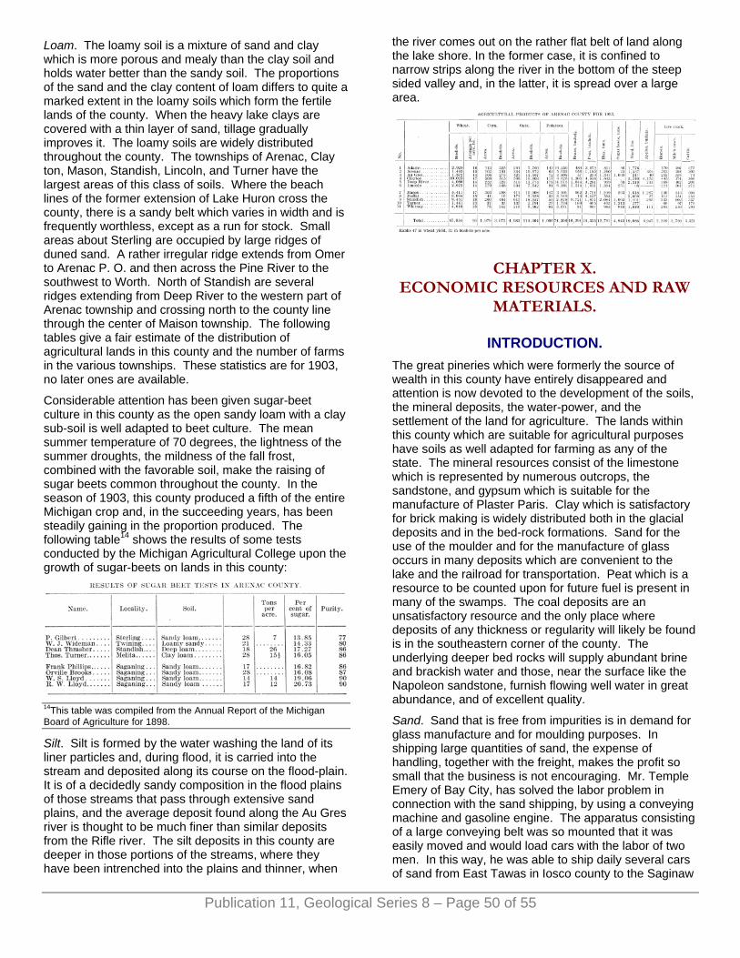
Loam. The loamy soil is a mixture of sand and clay which is more porous and mealy than the clay soil and holds water better than the sandy soil. The proportions of the sand and the clay content of loam differs to quite a marked extent in the loamy soils which form the fertile lands of the county. When the heavy lake clays are covered with a thin layer of sand, tillage gradually improves it. The loamy soils are widely distributed throughout the county. The townships of Arenac, Clay ton, Mason, Standish, Lincoln, and Turner have the largest areas of this class of soils. Where the beach lines of the former extension of Lake Huron cross the county, there is a sandy belt which varies in width and is frequently worthless, except as a run for stock. Small areas about Sterling are occupied by large ridges of duned sand. A rather irregular ridge extends from Omer to Arenac P. O. and then across the Pine River to the southwest to Worth. North of Standish are several ridges extending from Deep River to the western part of Arenac township and crossing north to the county line through the center of Maison township. The following tables give a fair estimate of the distribution of agricultural lands in this county and the number of farms in the various townships. These statistics are for 1903, no later ones are available.
Considerable attention has been given sugar-beet culture in this county as the open sandy loam with a clay sub-soil is well adapted to beet culture. The mean summer temperature of 70 degrees, the lightness of the summer droughts, the mildness of the fall frost, combined with the favorable soil, make the raising of sugar beets common throughout the county. In the season of 1903, this county produced a fifth of the entire Michigan crop and, in the succeeding years, has been steadily gaining in the proportion produced. The following table14 shows the results of some tests conducted by the Michigan Agricultural College upon the growth of sugar-beets on lands in this county:
Publication 11, Geological Series 8 – Page 50 of 55
14This table was compiled from the Annual Report of the Michigan Board of Agriculture for 1898.
Silt. Silt is formed by the water washing the land of its liner particles and, during flood, it is carried into the stream and deposited along its course on the flood-plain. It is of a decidedly sandy composition in the flood plains of those streams that pass through extensive sand plains, and the average deposit found along the Au Gres river is thought to be much finer than similar deposits from the Rifle river. The silt deposits in this county are deeper in those portions of the streams, where they have been intrenched into the plains and thinner, when
the river comes out on the rather flat belt of land along the lake shore. In the former case, it is confined to narrow strips along the river in the bottom of the steep sided valley and, in the latter, it is spread over a large area.
CHAPTER X. ECONOMIC RESOURCES AND RAW
MATERIALS.
INTRODUCTION. The great pineries which were formerly the source of wealth in this county have entirely disappeared and attention is now devoted to the development of the soils, the mineral deposits, the water-power, and the settlement of the land for agriculture. The lands within this county which are suitable for agricultural purposes have soils as well adapted for farming as any of the state. The mineral resources consist of the limestone which is represented by numerous outcrops, the sandstone, and gypsum which is suitable for the manufacture of Plaster Paris. Clay which is satisfactory for brick making is widely distributed both in the glacial deposits and in the bed-rock formations. Sand for the use of the moulder and for the manufacture of glass occurs in many deposits which are convenient to the lake and the railroad for transportation. Peat which is a resource to be counted upon for future fuel is present in many of the swamps. The coal deposits are an unsatisfactory resource and the only place where deposits of any thickness or regularity will likely be found is in the southeastern corner of the county. The underlying deeper bed rocks will supply abundant brine and brackish water and those, near the surface like the Napoleon sandstone, furnish flowing well water in great abundance, and of excellent quality.
Sand. Sand that is free from impurities is in demand for glass manufacture and for moulding purposes. In shipping large quantities of sand, the expense of handling, together with the freight, makes the profit so small that the business is not encouraging. Mr. Temple Emery of Bay City, has solved the labor problem in connection with the sand shipping, by using a conveying machine and gasoline engine. The apparatus consisting of a large conveying belt was so mounted that it was easily moved and would load cars with the labor of two men. In this way, he was able to ship daily several cars of sand from East Tawas in Iosco county to the Saginaw

Glass works. There is ample opportunity for the same methods to be employed with some of the sand that could be obtained from the sand ridges about Omer, Sterling, Deep River and Quinns. The surface litter to the depth of a foot or more has to be carefully removed when deposits are worked for sand. Near the limestone outcrops there are abundant deposits of sand and when the two resources are located near good transportation facilities, sand-lime brick might be manufactured.
GYPSUM. This is a valuable deposit when it occurs in sufficient thickness to make working profitable. Gypsum is a sulphate of lime which has united with a certain amount of water. When this water is driven off by boiling, the remaining mineral residue is the Plaster of Paris of commerce. Gypsum is very useful in some of its impure forms as a land plaster. The value of gypsum as a fertilizer and its many uses is fully discussed in the Report upon Gypsum for the Michigan Geological Survey by Grimsley.1 The occurrence of gypsum in the various wells of this country has been discussed in detail on previous pages of this report. On the map of the bed rock formations (Plate I), the region which is a good field for future working is indicated by the dotted lines. This comprises a small area in the vicinity of Twining and Turner, and a larger region on the Lake Huron shore near the Arenac-Iosco county line. The well records indicate that the above smaller area will not yield a vein of thickness to compare with the deposits farther north at Alabaster, but some impure gypsum may be taken out that can be used for land plaster.
Publication 11, Geological Series 8 – Page 51 of 55
1The Gypsum of Michigan by G. P. Grimsley. Geological Survey of Michigan, Volume 9, part II, page 198. Special attention is devoted to the deposits of Iosco and Arenac counties on pages 60-79.
LIMESTONE. The limestone of this county is valuable for road metal, lime burning, beet sugar manufacture, water-lime, and a rough building stone. It has been used for concrete grouting and construction work, railroad ballast, and as foundation for highway macadam. It has never been used very extensively as a building stone because it does not quarry in blocks of sufficient size. The foundations for a number of houses in Au Gres village were obtained from the Point Au Gres outcrop and it has shown good weather resisting qualities. It has been suggested that the cherty nodules that occur so freely in the limestone near Harmon City in section 24 township 20 N., R. 7 E., could be used for the grinding pebbles in the pulverizing mills in Portland Cement factories in place of those which are imported from Greenland for that purpose.
A. BURT’S LIME KILN AT OMER, MICHIGAN.
B. STRIPPING OF THE BURT QUARRY NORTHEAST OF
OMER, MICHIGAN.
Mr. Thomas Burt has opened a quarry in Sec. 1, T. 19 N., R. 5 E., on a limestone ridge which runs from the center of this section to the northwest corner and he finds that the stone found here in the layers above and below a six-inch layer of argillaceous sandstone to be excellent for burning. Mr. Burt has found a ready market for all of his product in this county and it is considered a good, strong lime. The following is an analysis made by the Dow Chemical Company of the top layer of limestone from Mr. Burt's quarry:
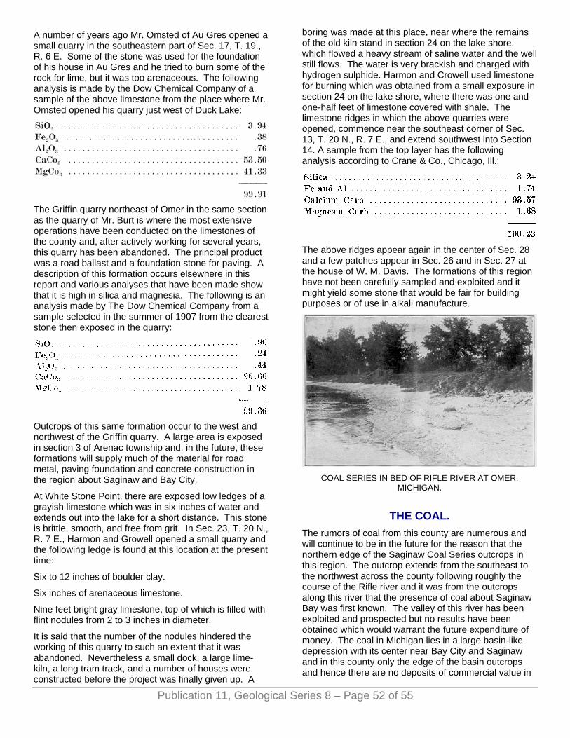
A number of years ago Mr. Omsted of Au Gres opened a small quarry in the southeastern part of Sec. 17, T. 19., R. 6 E. Some of the stone was used for the foundation of his house in Au Gres and he tried to burn some of the rock for lime, but it was too arenaceous. The following analysis is made by the Dow Chemical Company of a sample of the above limestone from the place where Mr. Omsted opened his quarry just west of Duck Lake:
The Griffin quarry northeast of Omer in the same section as the quarry of Mr. Burt is where the most extensive operations have been conducted on the limestones of the county and, after actively working for several years, this quarry has been abandoned. The principal product was a road ballast and a foundation stone for paving. A description of this formation occurs elsewhere in this report and various analyses that have been made show that it is high in silica and magnesia. The following is an analysis made by The Dow Chemical Company from a sample selected in the summer of 1907 from the clearest stone then exposed in the quarry:
Outcrops of this same formation occur to the west and northwest of the Griffin quarry. A large area is exposed in section 3 of Arenac township and, in the future, these formations will supply much of the material for road metal, paving foundation and concrete construction in the region about Saginaw and Bay City.
At White Stone Point, there are exposed low ledges of a grayish limestone which was in six inches of water and extends out into the lake for a short distance. This stone is brittle, smooth, and free from grit. In Sec. 23, T. 20 N., R. 7 E., Harmon and Growell opened a small quarry and the following ledge is found at this location at the present time:
Six to 12 inches of boulder clay.
Six inches of arenaceous limestone.
Nine feet bright gray limestone, top of which is filled with flint nodules from 2 to 3 inches in diameter.
It is said that the number of the nodules hindered the working of this quarry to such an extent that it was abandoned. Nevertheless a small dock, a large lime-kiln, a long tram track, and a number of houses were constructed before the project was finally given up. A
boring was made at this place, near where the remains of the old kiln stand in section 24 on the lake shore, which flowed a heavy stream of saline water and the well still flows. The water is very brackish and charged with hydrogen sulphide. Harmon and Crowell used limestone for burning which was obtained from a small exposure in section 24 on the lake shore, where there was one and one-half feet of limestone covered with shale. The limestone ridges in which the above quarries were opened, commence near the southeast corner of Sec. 13, T. 20 N., R. 7 E., and extend southwest into Section 14. A sample from the top layer has the following analysis according to Crane & Co., Chicago, Ill.:
The above ridges appear again in the center of Sec. 28 and a few patches appear in Sec. 26 and in Sec. 27 at the house of W. M. Davis. The formations of this region have not been carefully sampled and exploited and it might yield some stone that would be fair for building purposes or of use in alkali manufacture.
COAL SERIES IN BED OF RIFLE RIVER AT OMER,
MICHIGAN.
THE COAL. The rumors of coal from this county are numerous and will continue to be in the future for the reason that the northern edge of the Saginaw Coal Series outcrops in this region. The outcrop extends from the southeast to the northwest across the county following roughly the course of the Rifle river and it was from the outcrops along this river that the presence of coal about Saginaw Bay was first known. The valley of this river has been exploited and prospected but no results have been obtained which would warrant the future expenditure of money. The coal in Michigan lies in a large basin-like depression with its center near Bay City and Saginaw and in this county only the edge of the basin outcrops and hence there are no deposits of commercial value in
Publication 11, Geological Series 8 – Page 52 of 55
the valley of the Rifle river. The southeastern part of the county has not been satisfactorily tested but the wells which have been drilled for water in this district show no coal beds. The black shale, which is passed in drilling through the coal outcrops, always creates considerable excitement, but when a shaft is sunk or a careful test is made it always shows a bed of black shale intermingled with some white soft sandstone and underlain by a smooth clay.
THE CLAY. The Arenac county clay deposits are of three kinds, those formed by glacial action, the clays deposited in the former glacial lakes, and the shales of the Saginaw Coal Series. The glacial clay is tough and blue in color, with angular boulders, and contains pockets of sand and gravel. For brick manufacture it is not reliable because its content of lime has great variation in all of the beds which have been exploited in the county. The presence of small limestone pebbles is an injurious element which causes soft spots and blisters to form in bricks that are burned from this clay. A glacial clay which has been used in the manufacture of brick is that from the deposit which occurs in Mansfield creek at Shearer on the abandoned line of the Detroit and Mackinac railroad. A large quantity of brick of fair quality were burned from this clay. The lime and magnesia are low in this deposit which was never developed after the preliminary trial. There are many places where deposits of glacial clays occur in the county but it would hardly pay to exploit them when the lake clays and clays from the Michigan Coal Series are of a much better quality and more accessible to transportation facilities. At Standish, a small brick yard has been using material obtained from a four foot bed of glacial clay which contains quite a few small limestone pebbles. The bricks which contain these pebbles, when exposed to the air and moisture, are disintegrated by the slacking of the lime, and about three per cent of the entire output is damaged in this manner. If the clay was carefully crushed and screened to free it from these pebbles a much better product would be secured. At present, there is a good demand for a brick in this region and with more experience in handling this clay, these difficulties will be remedied. The following analysis has been made of the clay from this brickyard which is north of Standish on the Pine River.
A small brickyard was started near Pine River in Lincoln township and a lake clay was used which produced a fair building brick but, for some reason, the work was abandoned. The brick had ready sale and there was a fair demand. The clay was quite free from lime and
pebbles, and was easily worked. At Alger, on the Michigan Central railroad, a light sand covers the heavy clay east about one mile of the station in the eastern part of Sec. 10, T. 20 N., R. 3 E. This clay is high in magnesia and very gritty. It was sampled for the purpose of determining its value for use in the manufacture of Portland cement. The following analysis is a fair sample of the glacial clay from this region:
A test of the clay which occurs west of Sterling in Sec. 24, T. 19 N. and R. 3 E., shows it to be high in magnesia, silicon oxide, and comparatively free from all pebbles. At Summit, which is northwest from Sterling, the clay of the moraine there is very high in magnesia and the boulders and pebbles are numerous as well as the pockets of sand and gravel. A small brick and tile yard was started at Omer and the lake clay east of the railroad bridge and near the Rifle river was used. The brick produced was of excellent quality and there was a demand, but after a few trials the work was discontinued.
The clay of the Saginaw Coal Series outcrops very extensively along the banks of the Rifle river in the Pinnacle Hill region. In 1905, the Michigan Paving Brick Company was organized by several men2 of Saginaw and a plant was located northwest of Omer in Sec. 8, T. 19 N., R. 5 E., which is near the place where Mr. Stevens did considerable prospecting for coal. The plant is located on the flats north of the Rifle river in the above section and is connected by a spur track to the main line of the Detroit and Mackinac railroad. The clay is taken from the high banks south of the river.
"The beds have four feet of stripping, six to eight feet of dark shale, thirty-five feet of fire clay and at the bottom forty to fifty feet of dark shale." The capacity of the plant is 10 to 15 thousand of brick daily and 30 men are employed. The product is a light buff colored shale brick and the buyers speak very well of it." The writer visited the plant in 1907 and found about forty men employed and about eight to ten cars of paving brick being turned out each week. The black and blue shales of the Saginaw Coal Series were being taken from a pit forty feet deep located on the south bank of the river. The covering of five to eight feet was sand with much coarse gravel. The top layer of rock was a white mottled sandstone filled with bits of coal and the broken stems of sigillaria, calamites, etc. This sandstone varies in thickness from three to five feet. Below it is about eight feet of a black bituminous shale which is very irregular in its bedding and the thickness of its layers. In this shale are many smooth, striated glacial boulders, some greenstones were found, as well as jasper conglomerates and several large pieces of gypsum.
Publication 11, Geological Series 8 – Page 53 of 55
Publication 11, Geological Series 8 – Page 54 of 55
Below the black shale is a cream colored shale with some streaks of sand. This is about five feet in thickness. The lowest layer of shale is mixed with a small part of the other clay and burns into a buff colored paving brick of excellent quality. The clay is the only one known in the county which would be of use in the manufacture of Portland cement. 2The writer is indebted to Mr. John Carrigan, Saginaw, Mich., one of the members of the company for the following information.
THE WATER RESOURCES. The water resources of the county consist of the power which may be obtained from the streams, the brines from the deeper wells, and the supply of surface and flowing well water for stock and domestic purposes. The water power is practically undeveloped, there being only one place, that at Omer, on the Rifle river, where the power has been utilized. The nearness of large centers of population like Bay City and Saginaw make a demand for power and with the modern long distance transmission facilities, streams of this character are rendered available. There are many smaller streams3 of the county that could be utilized for small feed mills during portions of the year, and, at the present time, there are several parties in the field exploiting the Rifle river with a view of its development in the near future. The utilization of the brine from the underlying rock is one which was carried on very extensively north and south of this county in the days, when the fuel was plentifully supplied by the waste from the saw mills. The brine was never used from the deep well owned by Norn at Standish. The well at the abandoned town of Harmon City on the Lake Huron shore was undeveloped and an attempt was made at Au Gres to reach the brine rock but the well was not drilled deep enough. Almost all of the present deep wells in the county show the presence of brine. The wells of the greatest value in the county are the flowing wells whose supply is uniform, and whose temperature is splendidly adapted for cooling purposes in the care of dairy products. These last wells are quite common and cost about fifty cents a foot and there is no indication of the deeper ones becoming readily exhausted. Some of the shallow flowing well districts show a decrease in the supply, and this is especially true of the wells about Twining and Standish where formerly a very strong-flow existed. It is difficult to secure a supply of water about Alger and Culver, the shallow wells in this vicinity going dry in the summer's drought and the deeper wells not showing any water bearing beds that yield much quantity. The water obtained from the surface wells in the gypsum area is so bitter and brackish that it is not at all suitable for domestic use and the stock will not drink it. In this region, by going down to the Napoleon sandstone a very plentiful flow of pure water is obtained. Flows are also obtained in the sandstones and limestones of the Upper and Lower Grand Rapids but the quality and the supply is not so certain. Plate I and II will enable one to estimate the
location and the depth of a well for flows from the Napoleon sandstone in this region. 3Full data of power, location, flowage, etc. will be found in the following numbers of the Water Supply papers issued by the United States Geological Survey, 83, 97, 129 and 170.
THE SOILS. The general distribution of the soils has been discussed in detail in a previous chapter and it would be well to again call attention to the fertility of large tracts of land within this county to correct some impressions that this section is largely "jack pine" plains or swamp land. The most fertile soil of the county is a rich loamy soil that is quite widely distributed in the townships, varying in its mixture of glacial clay and sand. It is very fertile because of the ease with which the plant rootlets can penetrate it, the high percentage of lime and phosphates, and its capacity for moisture. In Clayton township, this is the prevailing soil and the 104 farms contain over nine thousand acres of improved land. The loamy soil forms the greater part of Arenac, Au Gres, Whitney, Mason, Turner, Lincoln, and parts of Deep River, Moffatt, and Adams. This soil seems especially adapted for wheat, oats, potatoes, and corn yields a fair crop. The cool summers, frequent rains, and the loamy soil furnish excellent conditions for the growth of potatoes, beans, peas, and sugar beets. Hay is a never failing crop. Alfalfa, clover, timothy, and millet all seem equally well adapted to this region. Many of the old log roads have been self-seeded from the hay used in the lumber camps and the abundant growth indicates the fertility of the land. Small fruit trees bear in great abundance. The apple, cherry, and plum seem to be best adapted to this region. In the region which produced abundant pine, the remaining stumps offer a serious obstacle to the man who begins farming in a small way and many acres of fertile lands are idle because of the cost of their removal. Pulling and dynamiting them is a greater expense than the average settler can afford.
Very recently a use has been found for the old pine stumps which makes them of commercial value which will about pay for their removal and this is the manufacture of turpentine and dynamite pulp. In several places in this part of Michigan where the stumps and jack pines are abundant, turpentine is being made on a commercial scale and just recently at Omer some experiments have been made on the use of the stumps for dynamite pulp. The frequent fires which have swept over this region have done much damage to the soil by destroying the covering of vegetable mould. On the clay lands, this is not a serious injury but, on the Sandy soils, renders them practically useless and more exposed to the washing action of the rain. From the swampy prairies along the lake shore, about Duck Lake and west of Moore's Junction, large quantities of marsh hay are annually cut and, about Ogden, the abundance of blue berries attracts a number of dealers who ship during the season large quantities of them to the markets in

Publication 11, Geological Series 8 – Page 55 of 55
Saginaw and Bay City. The sand of the "jack pine" plains is light and easily worked into shifting powder which renders travel over it very difficult. In some places, a good beginning has been made for better roads over parts of these plains by claying them. The road from Omer to Melita has been improved in the sandy places in this way as well as a part of the road from Deep River to Maple Ridge.
The most profitable use for the "jack pine" plains has been their use for grazing on an extensive scale. Where the plains have a supply of water from a river or a creek, a large area is fenced in and the cattle which are shipped in from the west are allowed to range from the early spring to the late fall. In parts of this county, Iosco, and Ogemaw, this method of preparing stock for the market has been very profitable.