Embed Size (px)
Citation preview

© 2007, Open Geospatial Consortium, Inc. • Helping the Wor© 2007, Open Geospatial Consortium, Inc. • Helping the World Communicate Geographicallyld Communicate Geographically
Overview of theOverview of theOpen Geospatial ConsortiumOpen Geospatial Consortium
Raj SinghDirector, Interoperability Programs
[email protected] +1 617 642-9372
Venice, Italy10 December 2007
© 2007, Open Geospatial Consortium, Inc. • Helping the Wor© 2007, Open Geospatial Consortium, Inc. • Helping the World Communicate Geographicallyld Communicate Geographically
OGC BackgroundOGC Background

© 2007, Open Geospatial Consortium, Inc. • Helping the World Communicate Geographically 3
Who is OGCWho is OGC
• an industry consortium for standards development
• software companies: Oracle, ESRI, MapInfo, Intergraph, Leica (Ionic), Google, Yahoo, Microsoft
• large users: US DoD, US Geologic Survey, Natural Resources Canada, European Commission Joint Resource Center, India Ministry of IT, UN FAO
• consultants: BAE Systems, Lockheed Martin, Northrop Grumman, engineering firms, GIS consulting firms
© 2007, Open Geospatial Consortium, Inc. • Helping the World Communicate Geographically 4
Our VisionOur Vision
A world in which all people and institutionsuse and benefit from spatial information
and supporting technology
geospatial ubiquity…
© 2007, Open Geospatial Consortium, Inc. • Helping the World Communicate Geographically 5
Open StandardsOpen Standards
. . . open standards prevent a single, self-interested party from controlling a standard, facilitate competition by lowering the cost of entry, and stimulate innovation beyond the standard by companies that seek to differentiate themselves. Customers value the interoperability that open standards provide and generally benefit from not being locked into a particular supplier.
Source: Open Standards, Open Source, and Open Innovation: Harnessing the Benefits of Openness, April 2006.
Committee For Economic Development. http://www.ced.org
© 2007, Open Geospatial Consortium, Inc. • Helping the World Communicate Geographically 6
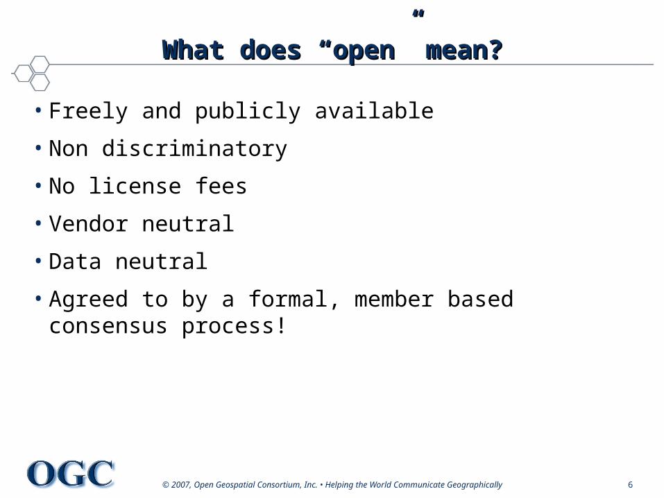
What does “open” mean?What does “open” mean?
• Freely and publicly available
• Non discriminatory
• No license fees
• Vendor neutral
• Data neutral
• Agreed to by a formal, member based consensus process!
© 2007, Open Geospatial Consortium, Inc. • Helping the World Communicate Geographically 7
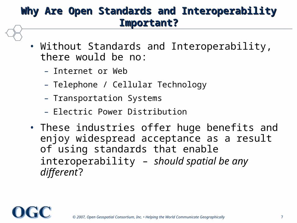
Why Are Open Standards and Interoperability Why Are Open Standards and Interoperability Important?Important?
• Without Standards and Interoperability, there would be no:– Internet or Web
– Telephone / Cellular Technology
– Transportation Systems
– Electric Power Distribution
• These industries offer huge benefits and enjoy widespread acceptance as a result of using standards that enable interoperability – should spatial be any different?
© 2007, Open Geospatial Consortium, Inc. • Helping the World Communicate Geographically 8
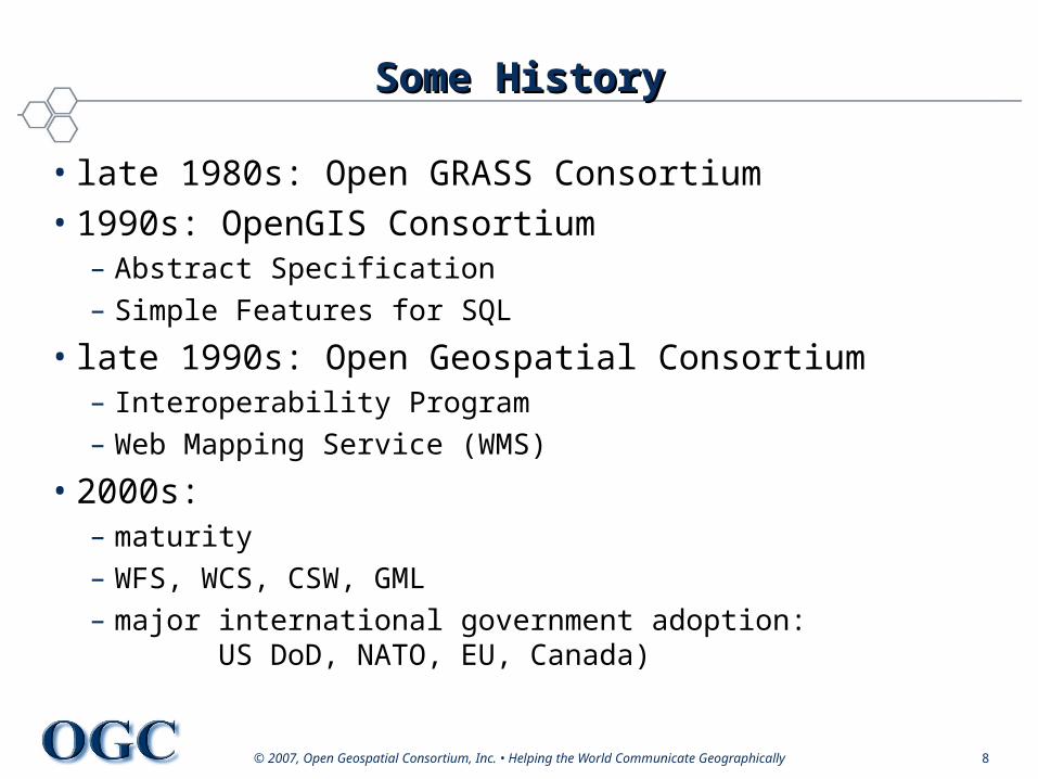
Some HistorySome History
• late 1980s: Open GRASS Consortium• 1990s: OpenGIS Consortium
– Abstract Specification– Simple Features for SQL
• late 1990s: Open Geospatial Consortium– Interoperability Program– Web Mapping Service (WMS)
• 2000s:– maturity– WFS, WCS, CSW, GML– major international government adoption:
US DoD, NATO, EU, Canada)
© 2007, Open Geospatial Consortium, Inc. • Helping the World Communicate Geographically 9
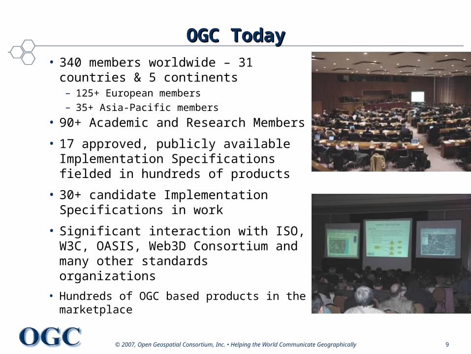
OGC TodayOGC Today• 340 members worldwide – 31
countries & 5 continents– 125+ European members – 35+ Asia-Pacific members
• 90+ Academic and Research Members
• 17 approved, publicly available Implementation Specifications fielded in hundreds of products
• 30+ candidate Implementation Specifications in work
• Significant interaction with ISO, W3C, OASIS, Web3D Consortium and many other standards organizations
• Hundreds of OGC based products in the marketplace
© 2007, Open Geospatial Consortium, Inc. • Helping the Wor© 2007, Open Geospatial Consortium, Inc. • Helping the World Communicate Geographicallyld Communicate Geographically
Major StandardsMajor Standards
© 2007, Open Geospatial Consortium, Inc. • Helping the World Communicate Geographically 11
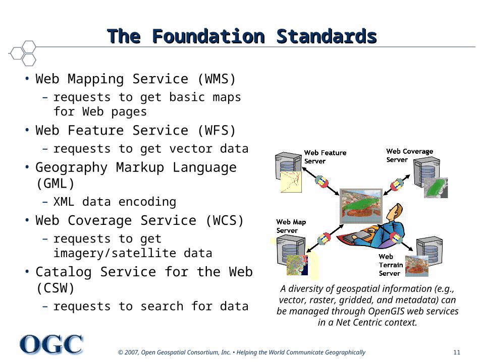
The Foundation StandardsThe Foundation Standards
• Web Mapping Service (WMS)– requests to get basic maps for
Web pages
• Web Feature Service (WFS)– requests to get vector data
• Geography Markup Language (GML)– XML data encoding
• Web Coverage Service (WCS)– requests to get imagery/satellite
data
• Catalog Service for the Web (CSW)– requests to search for data
A diversity of geospatial information (e.g., vector, raster, gridded, and metadata) can
be managed through OpenGIS web services in a Net Centric context.
© 2007, Open Geospatial Consortium, Inc. • Helping the World Communicate Geographically 12
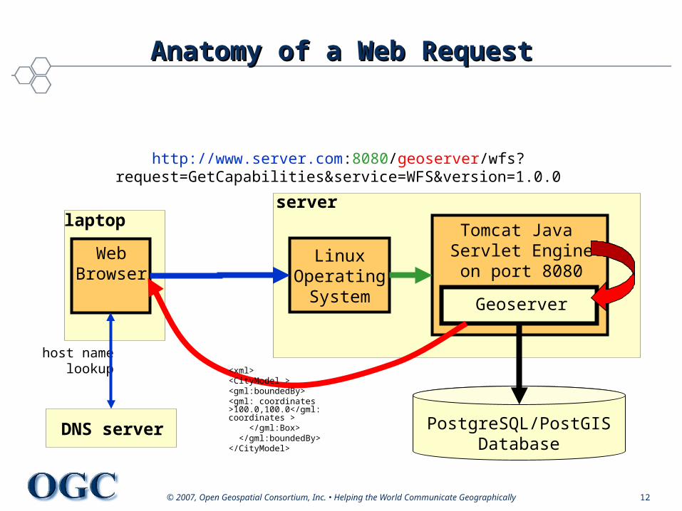
Anatomy of a Web RequestAnatomy of a Web Request
DNS server
LinuxOperating
System
PostgreSQL/PostGISDatabase
Tomcat Java Servlet Engineon port 8080
Geoserver
WebBrowser
laptopserver
host namelookup
http://www.server.com:8080/geoserver/wfs?request=GetCapabilities&service=WFS&version=1.0.0
<xml><CityModel ><gml:boundedBy><gml: coordinates >100.0,100.0</gml: coordinates > </gml:Box> </gml:boundedBy></CityModel>
© 2007, Open Geospatial Consortium, Inc. • Helping the World Communicate Geographically 13
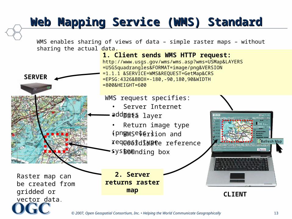
1. Client sends WMS HTTP request:http://www.usgs.gov/wms/wms.asp?wms=USMap&LAYERS=USGSquadrangles&FORMAT=image/png&VERSION=1.1.1 &SERVICE=WMS&REQUEST=GetMap&CRS=EPSG:4326&BBOX=-180,-90,180,90&WIDTH=800&HEIGHT=600
WMS request specifies:• Server Internet address
• Return image type (png, etc.)• WMS version and request type• Coordinate reference system • Bounding box
• Data layer
Raster map can be created from gridded or vector data.
2. Server returns raster map
SERVER
CLIENT
WMS enables sharing of views of data – simple raster maps – without sharing the actual data.
Web Mapping Service (WMS) StandardWeb Mapping Service (WMS) Standard
© 2007, Open Geospatial Consortium, Inc. • Helping the World Communicate Geographically 14
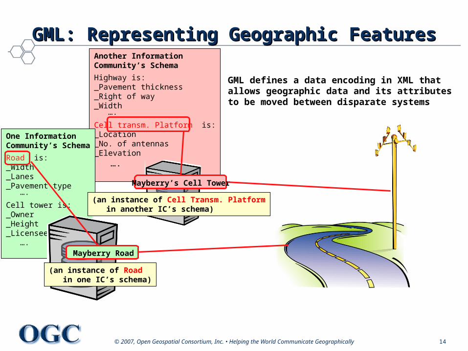
Another Information Community’s Schema
Highway is:_Pavement thickness_Right of way_Width ….
Cell transm. Platform is:_Location_No. of antennas_Elevation ….
One Information Community’s Schema
Road is:_Width_Lanes_Pavement type ….
Cell tower is:_Owner_Height_Licensees ….
(an instance of Road in one IC’s schema)
Mayberry’s Cell Tower
(an instance of Cell Transm. Platform in another IC’s schema)
Mayberry Road
GML defines a data encoding in XML that allows geographic data and its attributes to be moved between disparate systems
GML: Representing Geographic FeaturesGML: Representing Geographic Features
© 2007, Open Geospatial Consortium, Inc. • Helping the World Communicate Geographically 15
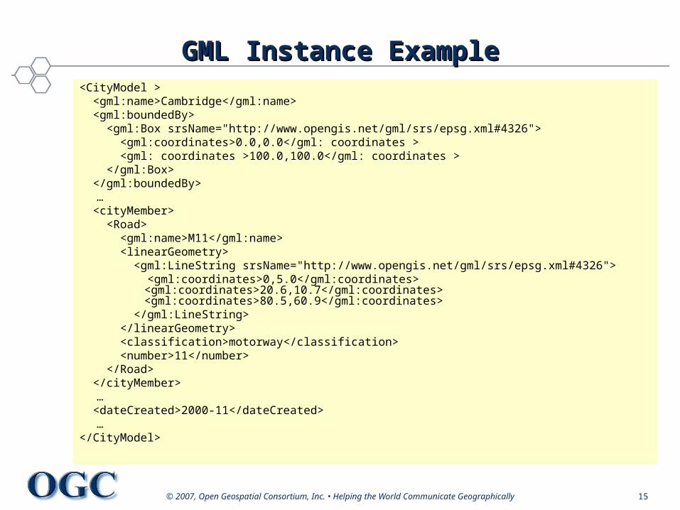
GML Instance ExampleGML Instance Example<CityModel > <gml:name>Cambridge</gml:name> <gml:boundedBy> <gml:Box srsName="http://www.opengis.net/gml/srs/epsg.xml#4326"> <gml:coordinates>0.0,0.0</gml: coordinates > <gml: coordinates >100.0,100.0</gml: coordinates > </gml:Box> </gml:boundedBy>
… <cityMember> <Road> <gml:name>M11</gml:name> <linearGeometry> <gml:LineString srsName="http://www.opengis.net/gml/srs/epsg.xml#4326"> <gml:coordinates>0,5.0</gml:coordinates>
<gml:coordinates>20.6,10.7</gml:coordinates> <gml:coordinates>80.5,60.9</gml:coordinates>
</gml:LineString> </linearGeometry> <classification>motorway</classification> <number>11</number> </Road> </cityMember>
… <dateCreated>2000-11</dateCreated>
…</CityModel>
© 2007, Open Geospatial Consortium, Inc. • Helping the World Communicate Geographically 16
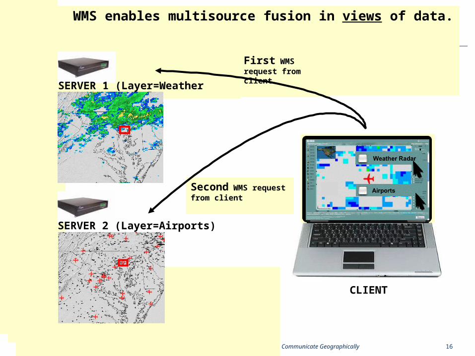
First WMS request from client
SERVER 1 (Layer=Weather Radar)
SERVER 2 (Layer=Airports)
Second WMS request from client
WMS enables multisource fusion in views of data.
CLIENT
© 2007, Open Geospatial Consortium, Inc. • Helping the World Communicate Geographically 17
Web Feature Service (WFS) StandardWeb Feature Service (WFS) Standard
• Geospatial data access in a web services architecture
• Lightweight, message-oriented data exchange
• Does not replace native GIS!

© 2007, Open Geospatial Consortium, Inc. • Helping the World Communicate Geographically 18
Request
WFS GetCapabilities OperationWFS GetCapabilities Operation
Client
Opaque Feature Store
Web Feature ServerWFS
Response
GetCapabilities<Service>
<Name>CubeWerx WFS</Name><Title>CubeWerx Web Feature Service</Title><Abstract>Web Feature Server maintained by X.</Abstract><OnlineResource>http://www.server.com/wfs.cgi?</OnlineResource>
</Service>
<!– Defines the list of feature types that this instance can operate upon and --><!-- which operations are supported on each feature type--><FeatureTypeList><Operations> <Query/> </Operations><FeatureType>
<Name>Roads</Name><SRS>EPSG:4326</SRS><LatLongBoundingBox minx="-179" miny="-85“ maxx="179“ maxy="83"/><Operations>
<Insert/><Update/><Delete/>
</Operations></FeatureType></FeatureTypeList>
<!– Defines the capabilities of the filter supported by this feature instance--><ogc:Filter_Capabilities>
<ogc:Spatial_Capabilities> <ogc:Spatial_Operators> <ogc:BBOX/> </ogc:Spatial_Operators>
</ogc:Spatial_Capabilities> </ogc:Filter_Capabilitites>
<Capability> <!-- defines which WFS operations this service supports, what DCP is supported --> <!-- for each service and what the entry points is for each operation--></Capability>
http://www.server.com/wfs.cgi?reques=GetCapabilities&service=WFS&version=1.1.0
© 2007, Open Geospatial Consortium, Inc. • Helping the World Communicate Geographically 19
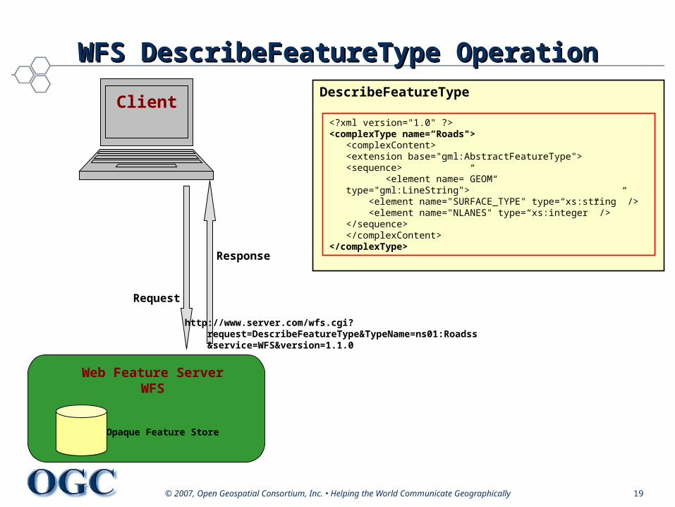
Request
WFS DescribeFeatureType OperationWFS DescribeFeatureType Operation
Client
Opaque Feature Store
Web Feature ServerWFS
Response
DescribeFeatureType
<?xml version="1.0" ?><complexType name=“Roads"> <complexContent>
<extension base="gml:AbstractFeatureType"><sequence>
<element name=”GEOM“ type="gml:LineString"> <element name="SURFACE_TYPE" type=“xs:string” /> <element name="NLANES" type=“xs:integer” /></sequence>
</complexContent></complexType>
http://www.server.com/wfs.cgi? request=DescribeFeatureType&TypeName=ns01:Roadss &service=WFS&version=1.1.0
© 2007, Open Geospatial Consortium, Inc. • Helping the World Communicate Geographically 20
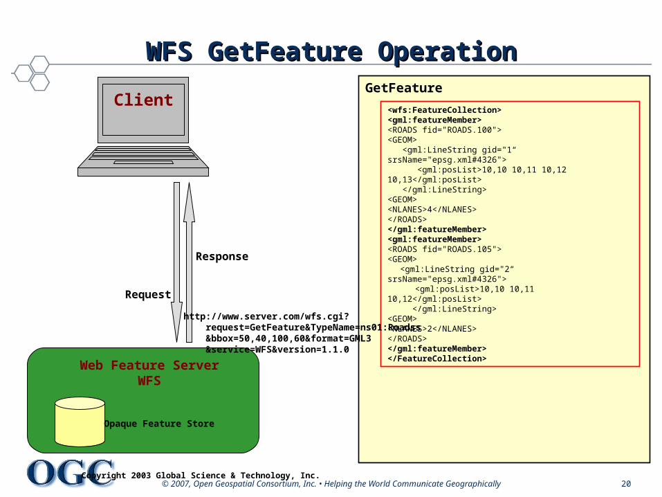
Request
WFS GetFeature OperationWFS GetFeature Operation
Client
Opaque Feature Store
Web Feature ServerWFS
Response
GetFeature
<wfs:FeatureCollection><gml:featureMember><ROADS fid="ROADS.100"><GEOM> <gml:LineString gid="1“ srsName="epsg.xml#4326"> <gml:posList>10,10 10,11 10,12 10,13</gml:posList> </gml:LineString><GEOM><NLANES>4</NLANES></ROADS></gml:featureMember><gml:featureMember><ROADS fid="ROADS.105"><GEOM>
<gml:LineString gid="2“ srsName="epsg.xml#4326"> <gml:posList>10,10 10,11 10,12</gml:posList>
</gml:LineString><GEOM><NLANES>2</NLANES></ROADS></gml:featureMember></FeatureCollection>
Copyright 2003 Global Science & Technology, Inc.
http://www.server.com/wfs.cgi? request=GetFeature&TypeName=ns01:Roadss &bbox=50,40,100,60&format=GML3 &service=WFS&version=1.1.0
© 2007, Open Geospatial Consortium, Inc. • Helping the Wor© 2007, Open Geospatial Consortium, Inc. • Helping the World Communicate Geographicallyld Communicate Geographically
Interoperability ProgramInteroperability Program
© 2007, Open Geospatial Consortium, Inc. • Helping the World Communicate Geographically 22
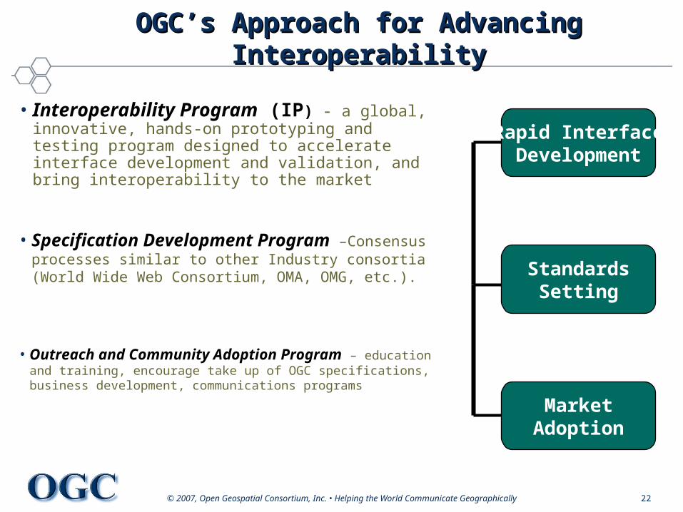
OGC’s Approach for Advancing OGC’s Approach for Advancing InteroperabilityInteroperability
• Interoperability Program (IP) - a global, innovative, hands-on prototyping and testing program designed to accelerate interface development and validation, and bring interoperability to the market
• Specification Development Program –Consensus processes similar to other Industry consortia (World Wide Web Consortium, OMA, OMG, etc.).
• Outreach and Community Adoption Program – education and training, encourage take up of OGC specifications, business development, communications programs
Rapid InterfaceDevelopment
StandardsSetting
MarketAdoption
© 2007, Open Geospatial Consortium, Inc. • Helping the World Communicate Geographically 23
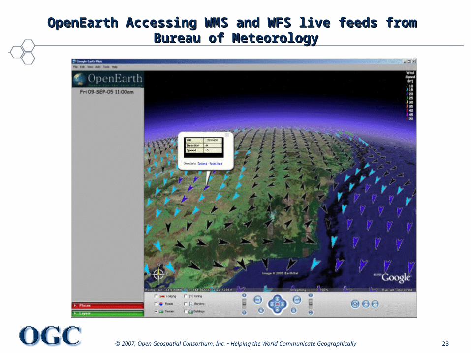
OpenEarth Accessing WMS and WFS live feeds from OpenEarth Accessing WMS and WFS live feeds from Bureau of MeteorologyBureau of Meteorology
© 2007, Open Geospatial Consortium, Inc. • Helping the World Communicate Geographically 24
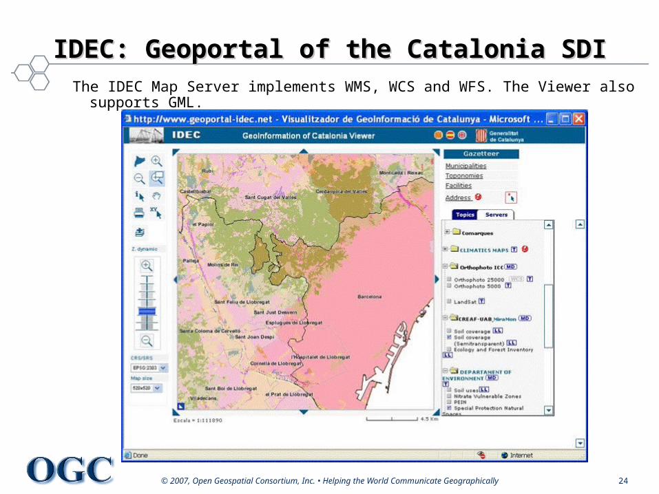
IDEC: Geoportal of the Catalonia SDIIDEC: Geoportal of the Catalonia SDIThe IDEC Map Server implements WMS, WCS and WFS. The Viewer also
supports GML.

© 2007, Open Geospatial Consortium, Inc. • Helping the World Communicate Geographically 25
Tsunami Information PortalTsunami Information Portal
Developed by DM Solutions in concert with Asian Institute of Technology, Chulalongkorn University, and Laboratory of Applied Geomatics. Uses OpenGIS WMS Interface
© 2007, Open Geospatial Consortium, Inc. • Helping the Wor© 2007, Open Geospatial Consortium, Inc. • Helping the World Communicate Geographicallyld Communicate Geographically
Neogeography and theNeogeography and theGeospatial WebGeospatial Web
© 2007, Open Geospatial Consortium, Inc. • Helping the World Communicate Geographically 27
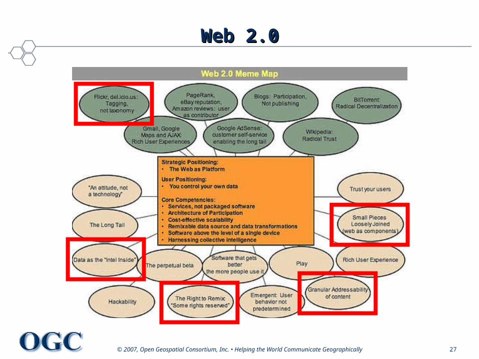
Web 2.0Web 2.0
© 2007, Open Geospatial Consortium, Inc. • Helping the World Communicate Geographically 28
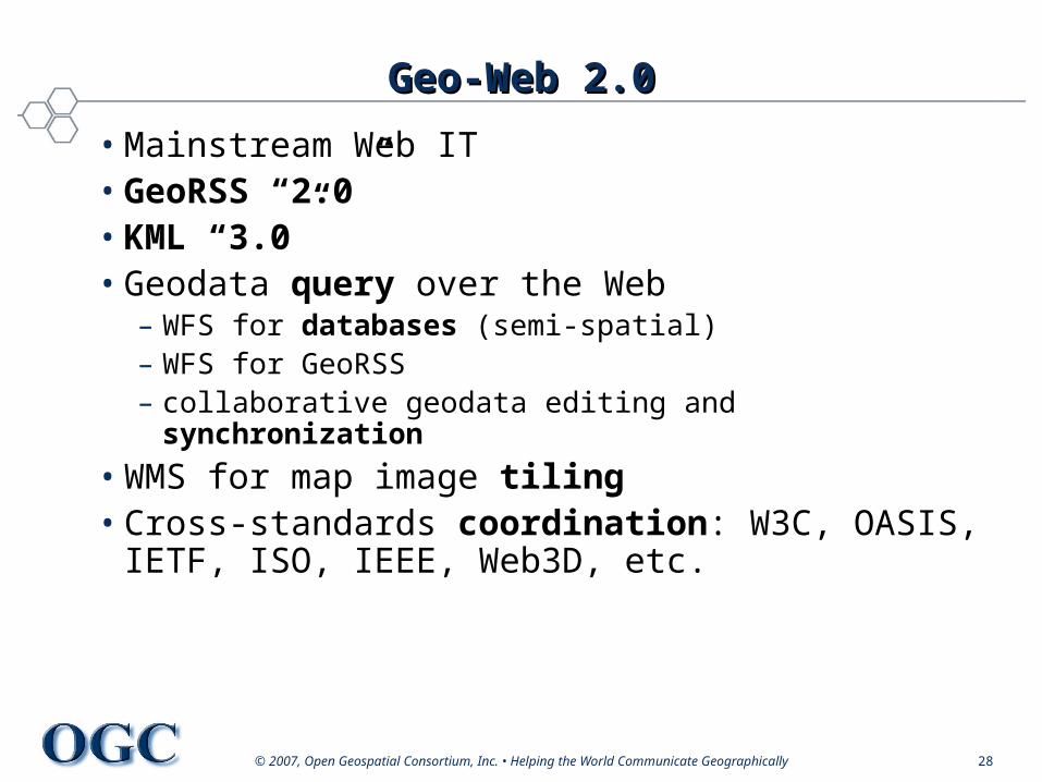
Geo-Web 2.0Geo-Web 2.0
• Mainstream Web IT• GeoRSS “2.0”• KML “3.0”• Geodata query over the Web
– WFS for databases (semi-spatial)– WFS for GeoRSS– collaborative geodata editing and synchronization
• WMS for map image tiling• Cross-standards coordination: W3C, OASIS,
IETF, ISO, IEEE, Web3D, etc.
© 2007, Open Geospatial Consortium, Inc. • Helping the World Communicate Geographically 29
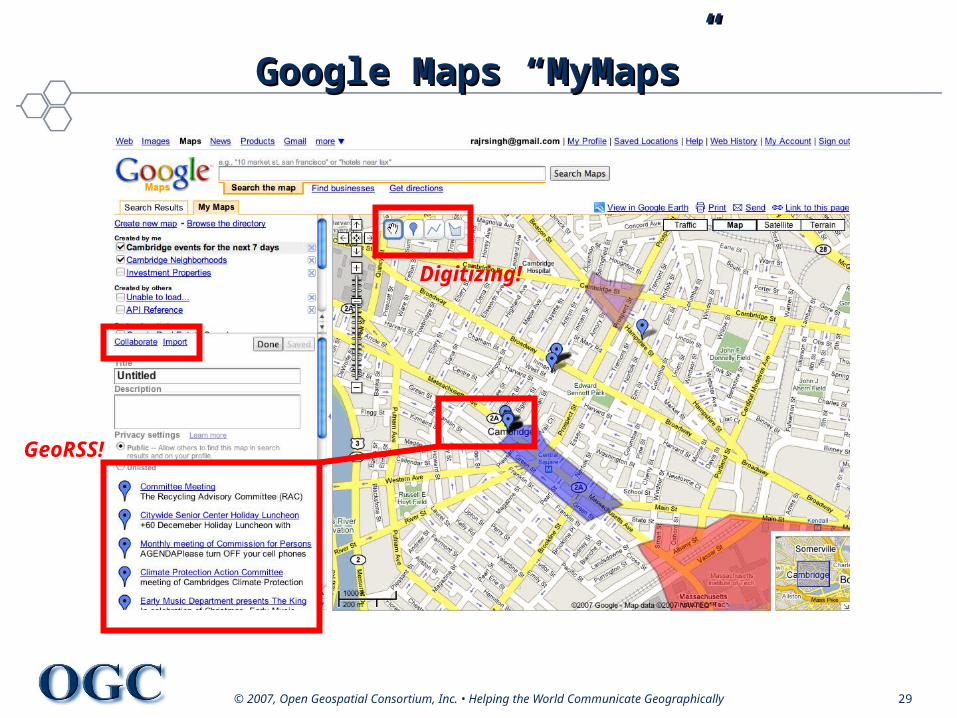
Google Maps “MyMaps”Google Maps “MyMaps”
GeoRSS!
Digitizing!

© 2007, Open Geospatial Consortium, Inc. • Helping the World Communicate Geographically 30
Geographic SearchGeographic Search
© 2007, Open Geospatial Consortium, Inc. • Helping the World Communicate Geographically 31
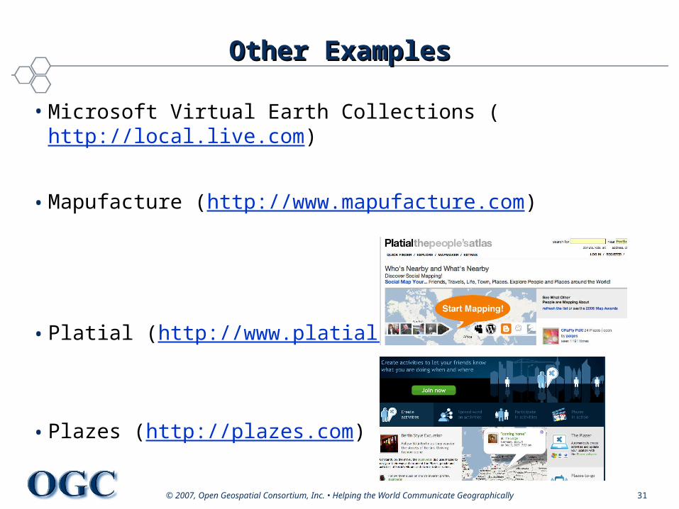
Other ExamplesOther Examples
• Microsoft Virtual Earth Collections (http://local.live.com)
• Mapufacture (http://www.mapufacture.com)
• Platial (http://www.platial.com)
• Plazes (http://plazes.com)

© 2007, Open Geospatial Consortium, Inc. • Helping the Wor© 2007, Open Geospatial Consortium, Inc. • Helping the World Communicate Geographicallyld Communicate Geographically
GeoRSS in a nutshellGeoRSS in a nutshell
© 2007, Open Geospatial Consortium, Inc. • Helping the World Communicate Geographically 33
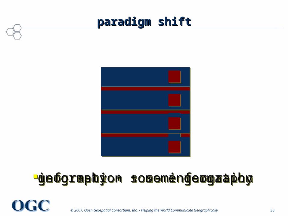
paradigm shiftparadigm shift
geography + some informationgeography + some informationinformation + some geographyinformation + some geography
© 2007, Open Geospatial Consortium, Inc. • Helping the World Communicate Geographically 34
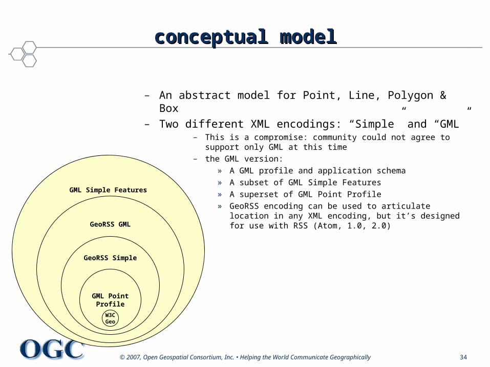
conceptual modelconceptual model
– An abstract model for Point, Line, Polygon & Box– Two different XML encodings: “Simple” and “GML”
– This is a compromise: community could not agree to support only GML at this time
– the GML version: » A GML profile and application schema» A subset of GML Simple Features» A superset of GML Point Profile» GeoRSS encoding can be used to articulate location in
any XML encoding, but it’s designed for use with RSS (Atom, 1.0, 2.0)
GML Simple Features
GeoRSS GML
GeoRSS Simple
GML PointProfile
W3CGeo
© 2007, Open Geospatial Consortium, Inc. • Helping the World Communicate Geographically 35
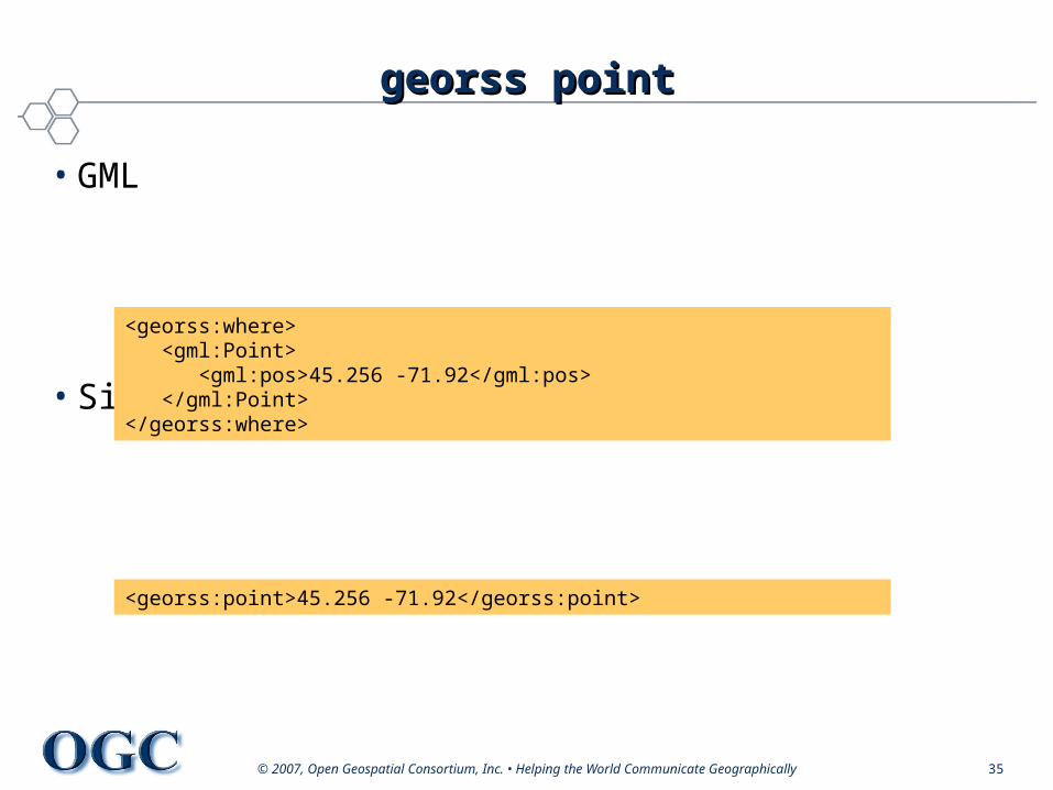
georss pointgeorss point
• GML
• Simple
<georss:point>45.256 -71.92</georss:point>
<georss:where> <gml:Point> <gml:pos>45.256 -71.92</gml:pos> </gml:Point></georss:where>
© 2007, Open Geospatial Consortium, Inc. • Helping the World Communicate Geographically 36
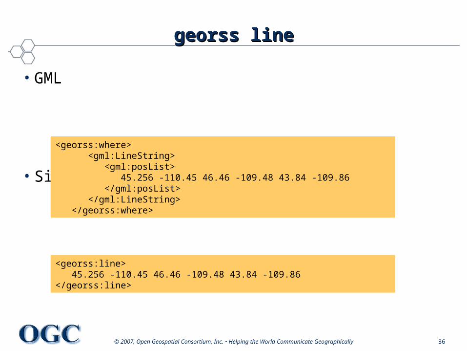
georss linegeorss line
• GML
• Simple
<georss:line> 45.256 -110.45 46.46 -109.48 43.84 -109.86</georss:line>
<georss:where> <gml:LineString> <gml:posList> 45.256 -110.45 46.46 -109.48 43.84 -109.86 </gml:posList> </gml:LineString> </georss:where>
© 2007, Open Geospatial Consortium, Inc. • Helping the World Communicate Geographically 37
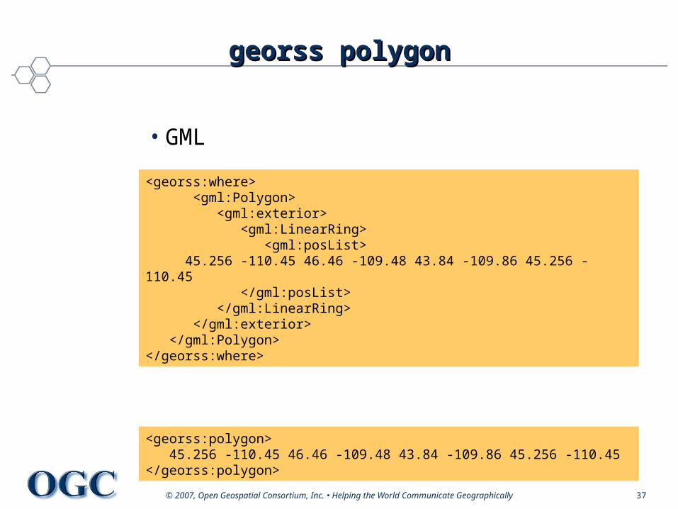
georss polygongeorss polygon
• GML
• Simple
<georss:where> <gml:Polygon> <gml:exterior> <gml:LinearRing> <gml:posList> 45.256 -110.45 46.46 -109.48 43.84 -109.86 45.256 -110.45 </gml:posList> </gml:LinearRing> </gml:exterior> </gml:Polygon></georss:where>
<georss:polygon> 45.256 -110.45 46.46 -109.48 43.84 -109.86 45.256 -110.45</georss:polygon>
© 2007, Open Geospatial Consortium, Inc. • Helping the World Communicate Geographically 38
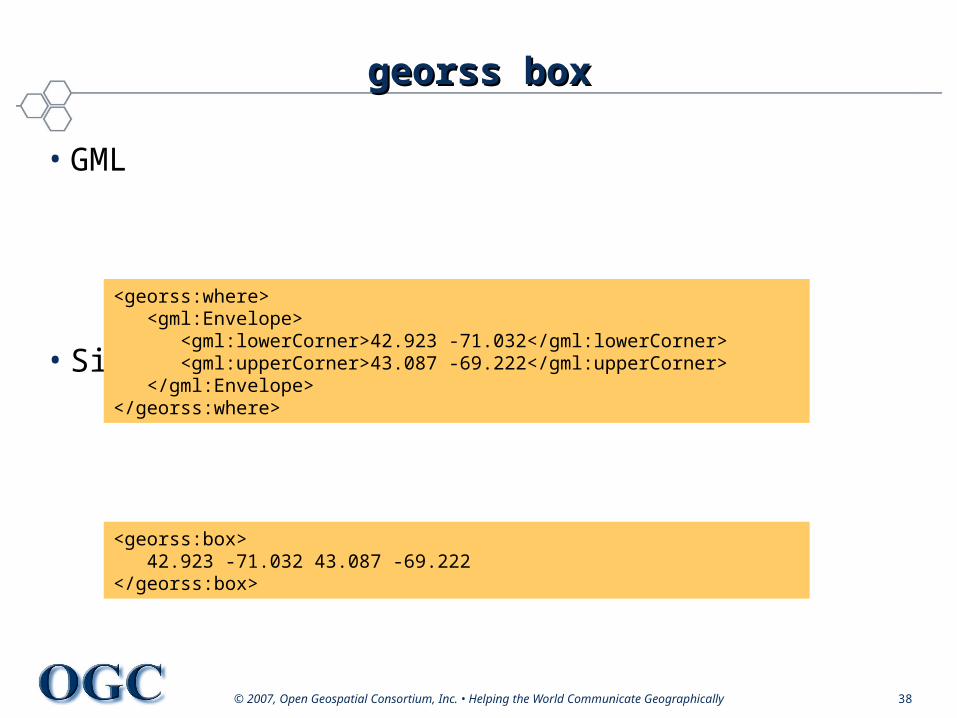
georss boxgeorss box
• GML
• Simple
<georss:box> 42.923 -71.032 43.087 -69.222</georss:box>
<georss:where> <gml:Envelope> <gml:lowerCorner>42.923 -71.032</gml:lowerCorner> <gml:upperCorner>43.087 -69.222</gml:upperCorner> </gml:Envelope></georss:where>
© 2007, Open Geospatial Consortium, Inc. • Helping the World Communicate Geographically 39
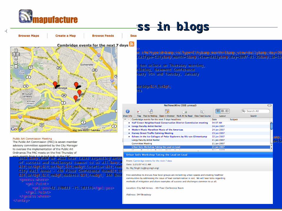
<entry> <title>License Commission Decision-Making Hearing</title> <link rel="via” href="http://www.cambridgema.gov/Calendar.cfm?typeid=&calType=City&month=1&view=daily&day=2007-01-25&id=15525" /> <id>http://www.cambridgema.gov/Calendar.cfm?typeid=&calType=City&month=1&view=daily&day=2007-01-25&id=15525</id> <updated>2007-01-25:00</updated> <content type="html">The License Commission will meet at ten oclock on Thursday morning, January 25, 2007 in the Michael J. Lombardi Municipal Building, Basement Conference Room, to make decisions on hearings held on Tuesday, January 9th and Tuesday, January 23, 2007.Elizabeth Y. Lint, Executive Officer <br/><br/><em>Location:</em> Lombardi Building - Conference Room-Basement Level , Cambridge<br> <br/><em>Address:</em> 831 Massachusetts Avenue</content> <georss:where> <gml:Point> <gml:pos>42.367199 -71.106418</gml:pos> </gml:Point> </georss:where></entry><entry> <title>Urban Soils Workshop Taking the Lead on Lead</title> <link rel="via" href="http://www.cambridgema.gov/Calendar.cfm?typeid=&calType=City&month=1&view=daily&day=2007-01-25&id=15668" /> <id>http://www.cambridgema.gov/Calendar.cfm?typeid=&calType=City&month=1&view=daily&day=2007-01-25&id=15668</id> <updated>2007-01-25:00</updated> <content type="html">Free workshop to discuss how local groups are reclaiming urban spaces and creating healthier communities by addressing the issue of lead contamination in soil.&#160 We will hear talks regarding methods of mitigation and share examples of success and challenges common to us all.&#160 <br/><br/><em>Location:</em> City Hall Annex - 4th Floor Conference Room<br> <br/><em>Address:</em> 344 Broadway </content> <georss:where> <gml:Point> <gml:pos>42.370033 -71.103176</gml:pos> </gml:Point> </georss:where></entry>
<entry> <title>License Commission Decision-Making Hearing</title> <link rel="via” href="http://www.cambridgema.gov/Calendar.cfm?typeid=&calType=City&month=1&view=daily&day=2007-01-25&id=15525" /> <id>http://www.cambridgema.gov/Calendar.cfm?typeid=&calType=City&month=1&view=daily&day=2007-01-25&id=15525</id> <updated>2007-01-25:00</updated> <content type="html">The License Commission will meet at ten oclock on Thursday morning, January 25, 2007 in the Michael J. Lombardi Municipal Building, Basement Conference Room, to make decisions on hearings held on Tuesday, January 9th and Tuesday, January 23, 2007.Elizabeth Y. Lint, Executive Officer <br/><br/><em>Location:</em> Lombardi Building - Conference Room-Basement Level , Cambridge<br> <br/><em>Address:</em> 831 Massachusetts Avenue</content> <georss:where> <gml:Point> <gml:pos>42.367199 -71.106418</gml:pos> </gml:Point> </georss:where></entry><entry> <title>Urban Soils Workshop Taking the Lead on Lead</title> <link rel="via" href="http://www.cambridgema.gov/Calendar.cfm?typeid=&calType=City&month=1&view=daily&day=2007-01-25&id=15668" /> <id>http://www.cambridgema.gov/Calendar.cfm?typeid=&calType=City&month=1&view=daily&day=2007-01-25&id=15668</id> <updated>2007-01-25:00</updated> <content type="html">Free workshop to discuss how local groups are reclaiming urban spaces and creating healthier communities by addressing the issue of lead contamination in soil.&#160 We will hear talks regarding methods of mitigation and share examples of success and challenges common to us all.&#160 <br/><br/><em>Location:</em> City Hall Annex - 4th Floor Conference Room<br> <br/><em>Address:</em> 344 Broadway </content> <georss:where> <gml:Point> <gml:pos>42.370033 -71.103176</gml:pos> </gml:Point> </georss:where></entry>
georss in blogsgeorss in blogs
© 2007, Open Geospatial Consortium, Inc. • Helping the World Communicate Geographically 40
current and future implementerscurrent and future implementers
• Cadcorp SIS, ESRI, Oracle• Google Earth and Maps• Mapufacture• Microsoft Virtual Earth v3• Platial• Yahoo! Maps API• OASIS Emergency Management TC for CAP and
EDXL
© 2007, Open Geospatial Consortium, Inc. • Helping the World Communicate Geographically 41
Success StoriesSuccess Stories
• UK Ordnance Survey using GML format to distribute its MasterMap product
• Canada Geospatial Data Infrastructure (CGDI) Endorses OGC Web Service Specifications
• Defense and Intelligence community adopting OGC as part of its Geospatial Enterprise Architecture.
• Australian SDI recognizes OGC standards, numerous enterprise implementations across the nation
• European Union INSPIRE technical architecture endorses OGC Web Services
• OGC underpins the DHS Geospatial Enterprise Architecture
• Open Location Services being built into consumer offerings from major location services vendors

© 2007, Open Geospatial Consortium, Inc. • Helping the Wor© 2007, Open Geospatial Consortium, Inc. • Helping the World Communicate Geographicallyld Communicate Geographically
backup slidesbackup slides
© 2007, Open Geospatial Consortium, Inc. • Helping the World Communicate Geographically 43
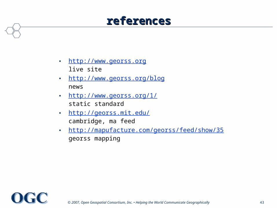
referencesreferences
• http://www.georss.orglive site
• http://www.georss.org/blognews
• http://www.georss.org/1/static standard
• http://georss.mit.edu/cambridge, ma feed
• http://mapufacture.com/georss/feed/show/35georss mapping