Embed Size (px)
Citation preview
ARCHAEOLOGICAL INVESTIGATION OF THE WILDERNESS GATEWAY RECREATION AREA,
CLEARWATER NATIONAL FOREST, IDAHO
by
Ruthann Knudson and Robert Lee Sappington
A Report in Fulfillment of Purchase Order 40-0276-7-745, ClearwaterNational Forest, Idaho; Distribution of This Report Only UponApproval of the Regional Forester, U. S. Forest Service, Region One,Federal Building, Missoula, Montana 59801 [Approved Requests Filledby the Laboratory of Anthropology, University of Idaho]
UNIVERSITY OF IDAHO ANTHROPOLOGICAL RESEARCH MANUSCRIPT SERIES NO. 41
Laboratory of Anthropology
University of Idaho
Moscow
1977
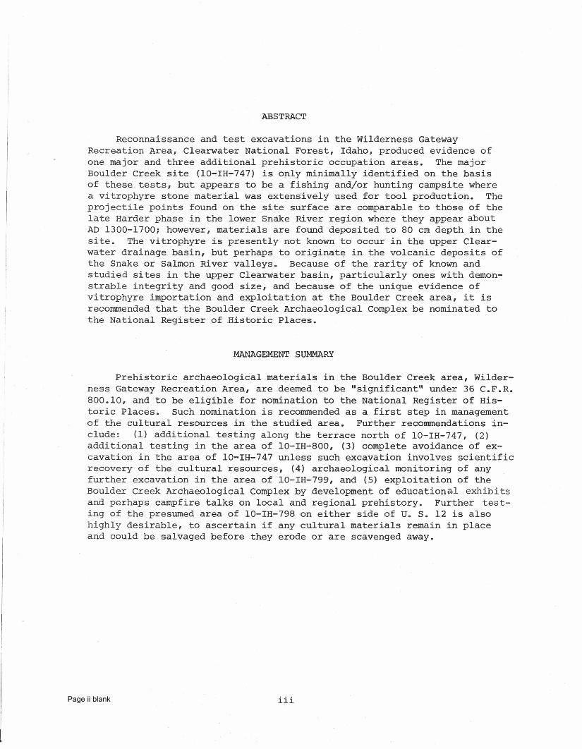
ABSTRACT
Reconnaissance and test excavations in the Wilderness GatewayRecreation Area, Clearwater National Forest, Idaho, produced evidence ofone major and three additional prehistoric occupation areas. The majorBoulder Creek site (10~IH-747) is only minimally identified on the basisof these tests, but appears to be a fishing and/or hunting campsite wherea vitrophyre stone material was ext.ensi.ve Ly used for tool production. Theprojectile points found on the site surface are comparable to those of thelate Harder phase in the lower Snake River region where they appear aboutAD 1300-1700; however, materials are found deposited to 80 cm depth in thesite. The vitrophyre is presently not known to occur in the upper Clear-water drainage basin, but perhaps to originate in the volcanic deposits ofthe Snake or Salmon River valleys. Because of the rarity of known andstudied sites in the upper Clearwater basin, particularly ones with demon-strable integrity and good size, and because of the unique evidence ofvitrophyre importation and exploitation at the Boulder Creek area, it isrecommended that the Boulder Creek Archaeological Complex be nominated tothe National Register of ,Historic Places.
MANAGEMENT SUMMARY
Prehistoric archaeological materials in the Boulder Creek area, Wilder-ness Gateway Recreation Area, are deemed to be "significant" under 36 C.F.R.800.10, and to be eligible for nomination to the National Register of His-toric Places. Such nomination is recommended as a first step in managementof the cultural resources in the studied area. Further recommendations in-clude: (1) additional testing along the terrace north of 10-IH-747, (2)additional testing in the area of 10-IH-800, (3) complete avoidance of ex-cavation in the area of 10-IH-747 unless such excavation involves scientificrecovery of the cultural resources, (4) archaeological monitoring of anyfurther excavation in the area of 10-IH-799, and (5) exploitation of theBoulder Creek Archaeological Complex by development of educ at.Lonad, exhibitsand perhaps campfire talks on local and regional prehistory~ Further test-ing of the presumed area of 10-IH-798 on either side of U. S. 12 is alsohighly desirable, to ascertain if any cultural materials remain in placeand could be salvaged before they erode or are scavenged away.
HiPage ii blank
ACKNOWLEDGEMENTS
Thomas J. Hudson and Andy Arvish of Clearwater National Forest firstnoticed the presence of cultural material at lO-IH-747 and brought it to theattention of Ruthann Knudson, and Hudson has been particularly helpful inproviding access to surface collections and background information relativeto Boulder Creek. Robert Lee Sappington served as field supervisor for thisproject, in unpleasant weather with very little time and few resources, and hasmade a considerable investment of interest in the area. Wayne Choquette wasa most supportive field crew member, with the assistance of Robert Friestadt,and Bob Garland volunteered several days' work. Edgar Bryan has been mosthelpful in searching for lithic resources within the upper Clearwater drain-age basin. Marion MacKubbin washed and labelled the collected artifacts,Karl Gurcke did the excellent tool photos, and Carl Ritchie assisted inartifact tabulations. Ruthann Knudson is responsible for drafting, drawing,and the final report preparation, and served as Principal Investigator ofthe project.
iv
TABLE OF CONTENTSPage
ABSTRACT . iii
HANAGEMENT SUMMARY iii
ACKNmVLEDGEMENTS . . iv
LIST OF ILLUSTRATIONS vi
LIST OF TABLES . . vi
1. INTRODUCTION 1
The ProblemThe Physical Environment, Past and PresentLocal Culture, Prehistory, and History.
114
2. PROJECT METHODS AND TECHNIQUES 5
Intensive Field Survey and Test ExcavationsLaboratory Analysis and Curation • . . .
56
3. THE BOULDER CREEK ARCHAEOLOGICAL COMPLEX 6
The General Area . . . . • . . .The Artifacts . ..... . . . . .The Boulder Creek Site (10-IH-747)Boulder Creek South (10-IH-799)Boulder Pack Road Site (10-IH-800)The Boulder Flat Terrace Site (10-IH-798)The Site Complex as a Remnant of an Adaptive Pattern •
67
2529303131
4. MANAGEMENT RECOMMENDATIONS ... 34
National Register of Historic Places Nomination 34Further Investigation of the Resource and Mitigation of
Adverse Effects . . • . 34
REFERENCES CITED 36
APPENDIX . . • . . 39A. SITE LOCATIONAL DATA, BOULDER CREEK ARCHAEOLOGICAL COMPLEX 41
B. FIELm'lORK LETTER REPORT (R. Knudson, 6 June 1977) 47
C. ARTIFACT AND DOCUMENT INVENTORY, BOULDER CREEK COMPLEX TEST 1977 49
v
LIST OF ILLUSTRATIONSFigure
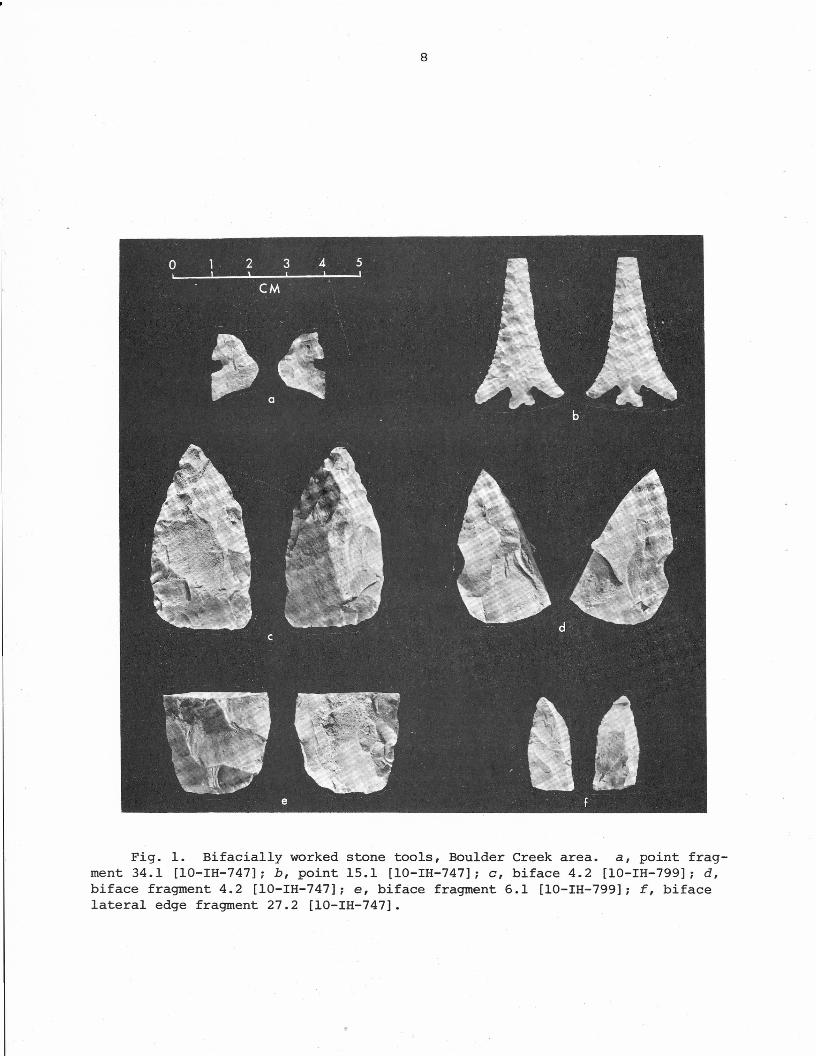
1. Bifacially worked stone tools, Boulder Creek areaPage
8
2. Original surface collection, 10-IH-747 9
3. Unifacially edged stone tools, Boulder Creek ArchaeologicalComplex . . . . . . . . . . . . • . 13
4. Choppers and hammerstone, Boulder Creek site 10-IH-747 19<
5. Vitrophyre cores or tabular core ends from the Boulder CreekArchaeological Complex , . . • . . . 22
6. Stratigraphic profiles of the south and west walls of TestPit 1, 10-IH-747, Boulder Creek Archaeological Com~lex 27
7. Test Pit I, 10-IH-747 . . . 28
8. Test Pit 2, 10-IH-747 30
9. Test pit 3, 10-IH-799 • . . ~ 31
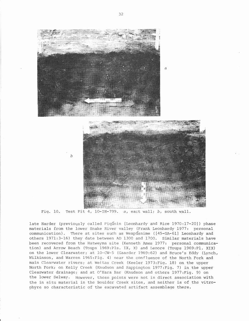
10. Test Pit 4, 10-IH-799 32
11. Topographic map of the Wilderness Gateway Recreation Area re-gion, with archaeological sites 10-IH-747, 10-IH-798, 10-IH-799,and 10-IH-800 designated within the suggested area of nominationto the National Register of Historic Places . . . • 43
12. Topographic map of the Boulder Creek Archaeological Complex area,with 1977 test pits located .•.•• , • . . • . 44
13. Panorama of Boulder Creek confluence with the Lochsa River, theWilderness Gateway Recreation Area . . • , . . 45
14. Archaeological sites lO-IH-747, 10-IH-798, and lO-IH-799 46
LIST OF TABLESTable Page
1. Distribution of lithic materials among the debitage flakesof the Boulder Creek Archaeological Complex, as recoveredby 1977 . . . . . . . . . . . . . . 25
2. Distribution of flake debitage by depth within test pits,10-IH-747 and 10-IH-799 . . . . • . . . . • 26
3. Inventory of artifacts and samples collected from Boulder CreekArchaeological Complex sites (10-IH-747, lO-IH-798, lO-IH-799,lO-IH-800) in 1976-77 by Forest Service personnel or the Labora-tory of Anthropology as Forest Service contractor . . . . • ., 50
vi
ARCHAEOLOGICAL INVESTIGATION OF THE WILDERNESS GATEWAY RECREATION AREA,CLEARWATER NATIONAL FOREST, IDAHO
1. INTRODUCTION
The Problem
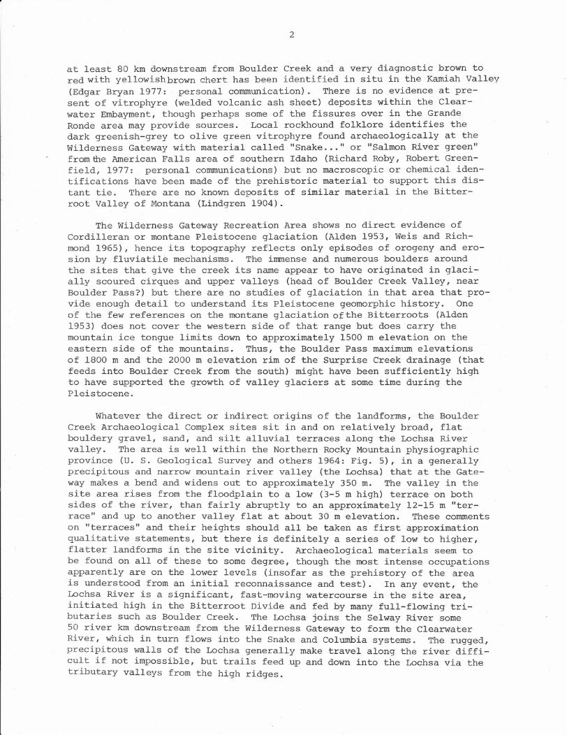
During summer 1976 staff members of Clearwater National Forest, Idaho,recovered prehistoric stone artifacts on a terrace within the WildernessGateway Recreation Area, Lochsa Ranger District, Clearwater National Forest.Consequently the Laboratory of Anthropology, University of Idaho, was re-quested to conduct an intensive survey and test excavation in the Area(P.O. 40-0276-7-745) to ascertain the existence of any cultural resourcesthere and their relative significance. Laboratory personnel were known tobe interested in the general region, had visited the site area several timesduring the winter and springof 1977, and were seeking public or privatemonies to investigate the possible cultural resources at Boulder Creek tosupplement the paucity of prehistoric data from the northern Idaho mountains.Consequently, during late May Laboratory archaeologists spent several daysat Wilderness Gateway walking over the terraces; looking at roadcuts, ro-dent holes, and river erosional cuts; and putting down several archaeolog-ical test pits. A brief letter report was submitted to the Forest Serviceupon completion of the fieldwork (Appendix B), and this manuscript is a re-port of those investigations with recommendations for future management ofthe area.
The area under investigation here is more precisely described and lo-cated, and illustrated, in Appendix A.
The Physical Environment, Past and Present
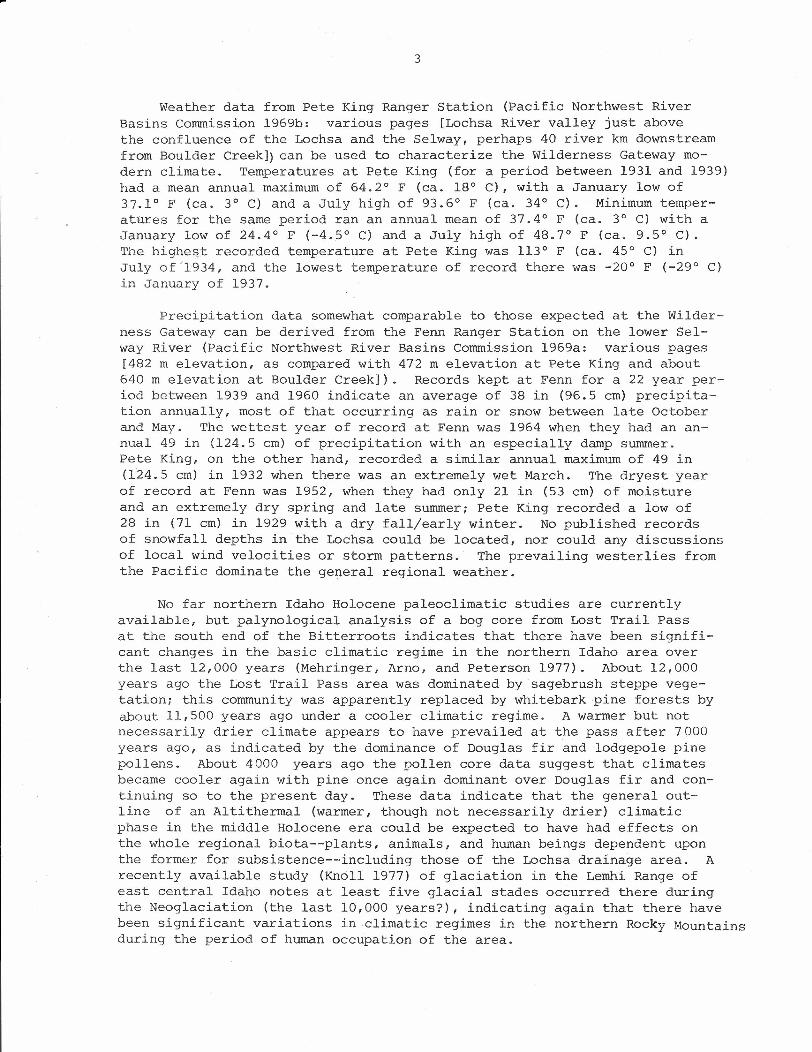
According to Anderson (1930: Pl. VII) the Wilderness Gateway RecreationArea is underlain by the Mesozoic granitic Idaho batholith, and this sameidentification is mapped by the U. S. Geological Survey and others (1964:Fig. 6). However, much of the northern and western borders of this batho·-lith are composed of more complexly metamorphosed gneisses and schists(Anderson 1930:28, U. S. Geological Survey and others 1964:32-33) and thereare no detailed geological data available from our study area to determinewhether or not Boulder Creek falls within this border zone. In anyevent, it is within a bedrock zone that as a general rule provides few orno lithic raw materials suitable for flaked stone tool production (e.g.,cherts, chalcedonies, argillites, or vitrophyres). However, north of theBoulder Creek area a minimum distance of at least 50 km there are bedrockdeposits of Belt Series sedimentary argillites and quartzites and some ofthese may have been suitable for flaking. To the west of Boulder Creek,downriver, there is a clear area of Batholithic border gneisses, then thevolcanic formations of the Clearwater Embayment (Bond 1963); the latterhave interbedded chalcedony/opalite layers, silicified woods, and workablebasalts. The closest deposits of these interbeds are in the Kooskia area
1
2
at least 80 km downstream from Boulder Creek and a very diagnostic brown tored with yellowishbrown chert has been identified in situ in the Kamiah Valley(Edgar Bryan 1977: personal communication). There is no evidence at pre-sent of vitrophyre (welded volcanic ash sheet) deposits within the Clear-water Embayment, though perhaps some of the fissures over in the GrandeRonde area may provide sources. Local rockhound folklore identifies thedark greenish-grey to olive green vitrophyre found archaeologically at theWilderness Gateway with material called "Snake ..•" or "Salmon River green"fromfue American Falls area of southern Idaho (Richard Roby, Robert Green-field, 1977: personal communications) but no macroscopic or chemical iden-tifications nave been made of the prehistoric material to support this dis-tant tie. There are no known deposits of similar material in the Bitter-root Valley of Montana (Lindgren 1904).
The Wilderness Gateway Recreation Area shows no direct evidence ofCordilleran or montane Pleistocene glaciation (Alden 1953, Weis and Rich-mond 1965), hence its topography reflects only episodes of orogeny and ero-sion by fluviatile mechanisms. The immense and numerous boulders aroundthe sites that give the creek its name appear to have originated in glaci-ally scoured cirques and upper valleys (head of Boulder Creek Valley, nearBoulder Pass?) but there are no studies of glaciation in that area that pro-vide enough detail to understand its Pleistocene geomorphic history. Oneof the few references on the montane glaciation of the Bitterroots (Alden1953) does not cover the western side of that range but does carry themountain ice tongue limits down to approximately 1500 m elevation on theeastern side of the mountains. Thus, the Boulder Pass maximum elevationsof 1800 m and the 2000 m elevation rim of the Surprise Creek drainage (thatfeeds into Boulder Creek from the south) might have been sufficiently highto have supported the growth of valley glaciers at some time during thePleistocene.
Whatever the direct or indirect origins of the landforms, the BoulderCreek Archaeological Complex sites sit in and on relatively broad, flatbouldery gravel, sand, and silt alluvial terraces along the Lochsa Rivervalley. The area is well within the Northern Rocky Mountain physiographicprovince (U. S. Geological Survey and others 1964: Fig. 5), in a generallyprecipitous and narrow mountain river valley (the Lochsa) that at the Gate-way makes a bend and widens out to approximately 350 m. The valley in thesite area rises from the floodplain to a low (3-5 m high) terrace on bothsides of the river, than fairly abruptly to an approximately 12-15 m "ter-race" and up to another valley flat at about 30 m elevation. These commentson "terraces" and their heights should all be taken as first approximationqualitative statements, but there is definitely a series of low to higher,flatter landforms in the site vicinity. Archaeological materials seem tobe found on all of these to some degree, though the most intense occupationsapparently are on the lower levels (insofar as the prehistory of the areais understood from an initial reconnaissance and test). In any event, theLochsa River is a significant, fast-moving watercourse in the site area,initiated high in the Bitterroot Divide and fed by many full-flowing tri-butaries such as Boulder Creek. The Lochsa joins the Selway River some50 river km downstream from the Wilderness Gateway to form the ClearwaterRiver, which in turn flows into the Snake and Columbia systems. The rugged,precipitous walls of the Lochsa generally make travel along the river diffi-cult if not impossible, but trails feed up and down into the Lochsa via thetributary valleys from the high ridges.
'"
3
Weather data from Pete King Ranger Station (Pacific Northwest RiverBasins Commission 1969b: various pages [Lochsa River valley just abovethe confluence of the Lochsa and the Selway, perhaps 40 river km downstreamfrom Boulder Creek]) can be used to characterize the Wilderness Gateway mo-dern climate. Temperatures at Pete King (for a period between 1931 and 1939)had a mean annual maximum of 64.2° F (ca. 18° C), with a January low of37.1° F (ca. 3° C) and a July high of 93.6° F (ca. 34° C). Minimum temper-atUres for the same period ran an annual mean of 37.4° F (ca. 3° C) with aJanuary low of 24.4° F (-4.5° C) and a July high of 48.7° F (ca. 9.5° C).The higheqt recorded temperature at Pete King was 113° F (ca. 45° C) inJuly of'1934, and the lowest temperature of record there was -20° F (-29° C)in January of 1937.
Precipitation data somewhat comparable to those expected at the Wilder-ness Gateway can be derived from the Fenn Ranger Station on the lower Sel-way River (Pacific Northwest River Basins Commission 1969a: various pages[482 m elevation, as compared with 472 m elevation at Pete King and about640 m elevation at Boulder Creek]). Records kept at Fenn for a 22 year per-iod between 1939 and 1960 indicate an average of 38 in (96.5 cm) precipita-tion annually, most of that occurring as rain or snow between late Octoberand May. The wettest year of record at Fenn was 1964 when they had an an-nual 49 in (124.5 cm) of precipitation with an especially damp summer.Pete King, on the other hand, recorded a similar annual maximum of 49 in(124.5 cm) in 1932 when there was an extremely wet March. The dryest yearof record at Fenn was 1952, when they had only 21 in (53 cm) of moistureand an extremely dry spring and late summer; Pete King recorded a low of28 in (71 cm) in 1929 with a dry fall/early winter. No published recordsof snowfall depths in the Lochsa could be located, nor could any discussionsof local wind velocities or storm patterns. The prevailing westerlies fromthe Pacific dominate the general regional weather.
No far northern Idaho Holocene paleoclimatic studies are currentlyavailable, but palynological analysis of a bog core from Lost Trail Passat the south end of the Bitterroots indicates that there have been signifi-cant changes in the basic climatic regime in the northern Idaho area overthe last 12,000 years (Mehringer, Arno, and Peterson 1977). About 12,000years ago the Lost Trail Pass area was dominated by sagebrush steppe vege-tation; this community was apparently replaced by whitebarkpine forests byabout 11,500 years ago under a cooler climatic regime. A warmer but notnecessarily drier climate appears to have prevailed at the pass after 7000years ago, as indicated by the dominance of Douglas fir and lodgepole pinepollens. About 4000 years ag'O the pollen core data suggest that climatesbecame cooler again with pine once again dominant over Douglas fir and con-tinuing so to the present day. These data indicate that the general out-line of an Altithermal (warmer, though not necessarily drier) climaticphase in the middle Holocene era could be expected to have had effects onthe whole regional biota--plants, animals, and human beings dependent uponthe former for subsistence--·including those of the Lochsa drainage area. Arecently available study (Knoll 1977) of glaciation in the Lemhi Range ofeast central Idaho notes at least five glacial stades occurred there duringthe Neoglaciation (the last 10,000 years?), indicating again that there havebeen significant variations in climatic regimes in the northern Rocky Mountainsduring the period of human occupation of the area.
4
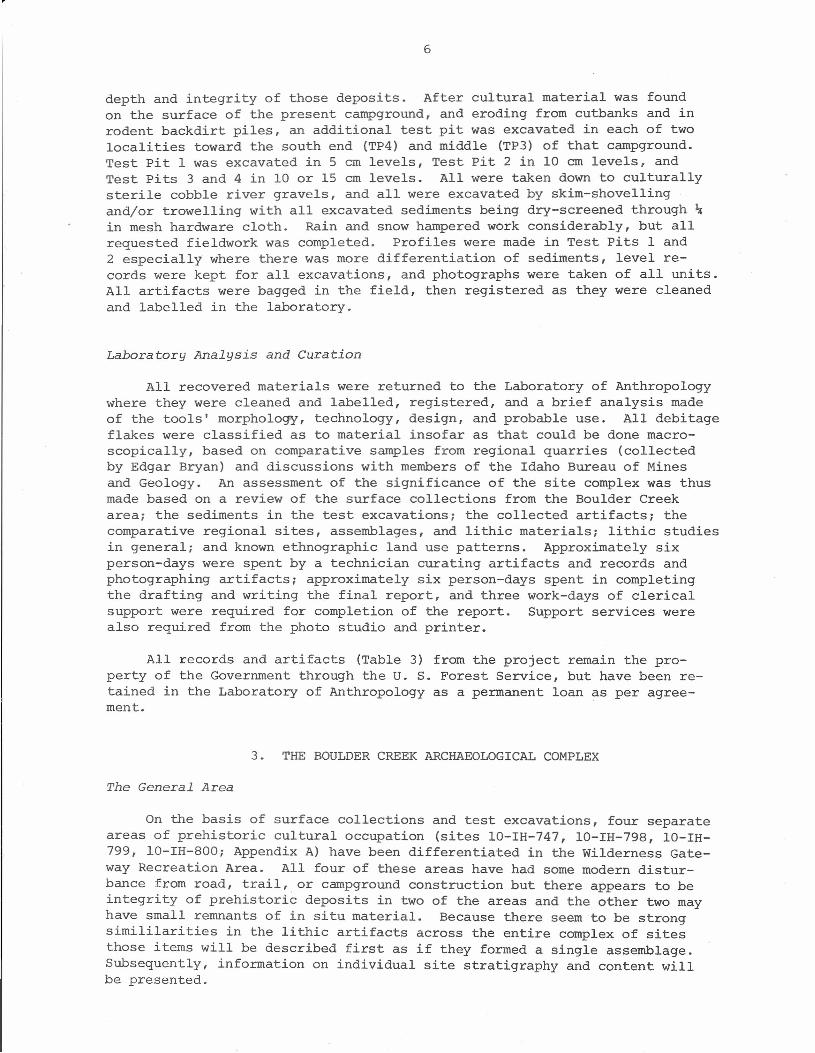
The vegetation in the Wilderness Gateway Recreation Area is heavilyburned from multiple fires in 1919 and 1934 (McLean 1972: Fig. 3, Space 1964:68-73) but the undergrowth present today as well as the burned snags indicatethat the habitat type in that area is Thuja plicata/Pachistima myrsinites(Daubenmire and Daubenmire 1968:29-31, McLean 1972:5). Today much of the areais in tall brush (e.g., Physocarpus malvaceus) with heavier forest vegetationonly in the area of site 10-IH-799. McLean (1972:5) notes that the tall shrubswithin this habitat type usually include Acer glabrum, Amelanchier alnifolia,Salix scouleriana, Prunus emarginata, Sambucus caerulea, Sorbus scopulina,and Cornus nuttallii; most of these were noted at Boulder Creek, as were manyof the medium and low shrubs and herbaceous plants usually found within thisplant union. bespite the fact that the area has not been burned for manyyears, the area of site 10-IH-747 especially is still dominated by standingand lying burned Thuja snags that must be over forty years old.
Animal resources are abundant today in the Wilderness Gateway area andmust have been in the past as well (though faunal community structures haveundoubtedly changed over time as the vegetation has been modified by fireand climatic changes). At present the extensive brushfields in the areaserve as winter and spring ranges for the Lochsa elk herd (Judd 1971, McLean1972, Space 1964:85), and deer are abundant. No bighorn sheep are found inthe area at present (Smith 1954:Fig. 9), but Buechner (1960:Fig. 1) includesthe Boulder Creek area within his zone of "probable distribution of bighornSheep ... prior to the advent of the white man." Moose, bear, and probablymountain lion are indigenous to the area. Small mammals have been trapped inthe Boulder Creek area historically (Space 1964:58), and anadromous as well asfreshwater fish are present i", the Lochsa River at the Boulder Creek conflu-ence. The area is not located on a major flyway and hence there are few con-centrationsof ducks and geese in the valley, but some game birds are presentin the more open area. As with other valley bottom terraces in the upperClearwater drainage basin, the abundant variety of plant and animal resourcesavailable at the Wilderness Gateway suggests that prehistoric occupation ofa camp there could occur at any time of the year dependent only upon snowdepth and spring runoff levels that would hinder travel.
Local Culture, Prehistory, and History
No extensive archaeological reconnaissance has ever been conducted in theLochsa River valley, and the Idaho State Archaeological Survey records onlysix prehistoric sites in the valley outside of the Boulder Creek confluencearea. Test excavations have been conducted recently at prehistoric sites inthe lower Selway River valley (Knudson and others 1977) and on Kelly Creek inthe upper North Fork of the Clearwater drainage (Knudson and Sappington 1977),but neither project has identified a temporal sequence for the area. Bothsites are known to have been occupied at least during the late Harder phase(AD 1300-1700) as that archaeological period is defined from the lower SnakeRiver (Frank Leonhardy 1977: personal communication), but artifacts diagnos-tic of earlier cultural units have not been found during these tests. TheWeitas Creek site (Keeler 1973, 1976) on the North Fork of the Clearwaterprovides the mo~t proximate evidence of long term occupation of the upperClearwater drainage, and can be used as a basis for generalization aboutthe culture history of that larger region. The Weitas Creek river terracesite has several levels of human occupation debris laid down within it,
5
and was certainly occupied intermittently over at least the last 7-6000years. Tool designs and stone materials from that site indicate culturalcontinuity with contemporary occupations in the lower Clearwater and Snakeriver valleys (Leonhardy and Rice 1970); contemporary materials from westernMontana are not well enough known yet to make comparisons with the east fromWeitas Creek. In addition to these sites, casual surveys of some of thepasses and ridges along the Bitterroot Divide between Idaho and Montana in-dicate the presence there of significant quantities of stone tools and manu-facturing debris (Edgar Bryan 1977: personal communication). All thesedata indicate that while there has been little formal archaeological recon-naissance of the northern Idaho mountains, there is good evidence far ex-tensive exploitation of the area and its resources by human beings for thou-sands of years.
There has been little comprehensive analysis of ethnographic Nez Percesettlement patterns (though see Chalfant 1974; Marshall 1977; Schwede 1966,1970; Shawley 1977), but most major winter villages of record were locatedat or below Kooskia on the Clearwater. However, fishing and hunting campswere known to have been made upriver from Kooskia on the various streamsand mountain trails. Stephen Shawley (1977) has recently completed a studyof ethnographic Nez Perce trails that unfortunately did not encompass thearea of the Wilderness Gateway (for limitations of time and money, not be-cause of lack of data on Nez Perce use of the area) but there is considerablefolk knowledge about trails through the area under study here. Space(1964:87-89) comments about Indian trails in the general Lochsa area inclu-ding one from Coolwater past Old Man Lake and branching to Fish Lake and theupper Lochsa; this may have eventually gone down Boulder Creek. Histori-cally there has been frequent use of a trail down Boulder Creek from FishLake to the Lochsa and Boulder Flat (Space 1964:46,97). The Forest Serviceestablished the Lochsa Ranger Station just downriver from Boulder Flat inthe 1930s (Space 1964:138), the Lewis and Clark Highway was first builtover (and through) Boulder Flat in the early 1950s (Space 1964:99), andthere has been extensive use of the Wilderness Gateway as a packing andcamping headquarters for some years. Because the focus of this project wason the prehistoric archaeology of the area there has been no exhaustive re-search through Forest Service records on the historic occupation aroundBoulder Creek, but it obviously has been extensive even if somewhat inter-mittent.
2. PROJECT METHODS AND TECHNIQUES
Intensive Field Survey and Test Excavations
Four fieldworkers spent five workdays in the field on this project,including transportation time from the University to the site and back,and an additional workday setting up for and cleaning up from the field-work. The Principal Investigator also visited the work area twice beforethis project began, and spent one workday of project time inspecting thearea and work. Initial reconnaissance was first made of the general Boulder-Lochsa confluence area, both on the west side of the Lochsa, in the knownarea of lO-IH-747 (based on previous surface finds), and in roadcuts anderoded river banks in the present campground and packroad areas. Two testpits (TPl, TP2) were put down in the area of lO-IH-747 to determine the
6
depth and integrity of those deposits. After cultural material was foundon the surface of the present campground, and eroding from cutbanks and inrodent backdirt piles, an additional test pit was excavated in each of twolocalities toward the south end (TP4) and middle (TP3) of that campground.Test Pit 1 was excavated in 5 cm levels, Test pit 2 in 10 em levels, andTest pits 3 and 4 in 10 or 15 cm levels. All were taken down to culturallysterile cobble river gravels, and all were excavated by skim-shovellingand/or trowelling with all excavated sediments being dry-screened through ~in mesh hardware cloth. Rain and snow hampered work considerably, but allrequested fieldwork was completed. Profiles were made in Test pits 1 and2 especially where there was more differentiation of sediments, level re-cords were kept for all excavations, and photographs were taken of all units.All artifacts were bagged in the field, then registered as they were cleanedand labelled in the laboratory.
Laboratory Analysis and Curation
All recovered materials were returned to the Laboratory of Anthropologywhere they were cleaned and labelled, registered, and a brief analysis madeof the tools' morphology, technology, design, and probable use. All debitageflakes were classified as to material insofar as that could be done macro-scopically, based on comparative samples from regional quarries (collectedby Edgar Bryan) and discussions with members of the Idaho Bureau of Minesand Geology. An assessment of the significance of the site complex was thusmade based on a review of the surface collections from the Boulder Creekarea; the sediments in the test excavations; the collected artifacts; thecomparative regional sites, assemblages, and lithic materials; lithic studiesin general; and known ethnographic land use patterns. Approximately sixperson-days were spent by a technician curating artifacts and records andphotographing artifacts; approximately six person-days spent in completingthe drafting and writing the final report, and three work-days of clericalsupport were required for completion of the report. Support services werealso required from the photo studio and printer.
All records and artifacts (Table 3) from the project remain the pro-perty of the Government through the U. S. Forest Service, but have been re-tained in the Laboratory of Anthropology as a permanent loan as per agree-ment.
3. THE BOULDER CREEK ARCHAEOLOGICAL COMPLEX
The General Area
On the basis of surface collections and test excavations, four separateareas of prehistoric cultural occupation (sites 10-IH-747, 10-IH-798, 10-IH-799, 10-IH-800; Appendix A) have been differentiated in the wilderness Gate-way Recreation Area. All four of these areas have had some modern distur-bance from road, trail, or campground construction but there appears to beintegrity of prehistoric deposits in two of the areas and the other two mayhave small remnants of in situ material. Because there seem to be strongsimililarities in the lithic artifacts across the entire complex of sitesthose items will be described first as if they formed a single assemblage.Subsequently, information on individual site stratigraphy and content willbe presented.
7
The Artifacts
Artifacts totalling 2094 were found during surface collectionof the four Boulder Creek Archaeological Complex sites, and duringtest excavations in 10-IH-747 and 10-IH-799. Almost all of these weredebitage flakes or small cores, but there were 24 identifiable retouchedor worked tools or tool fragments from this project.
Tools (24). Because there are so few of these, they are described indetail here. Descriptive terminology follows Knudson (1975).
Projectile points (2)
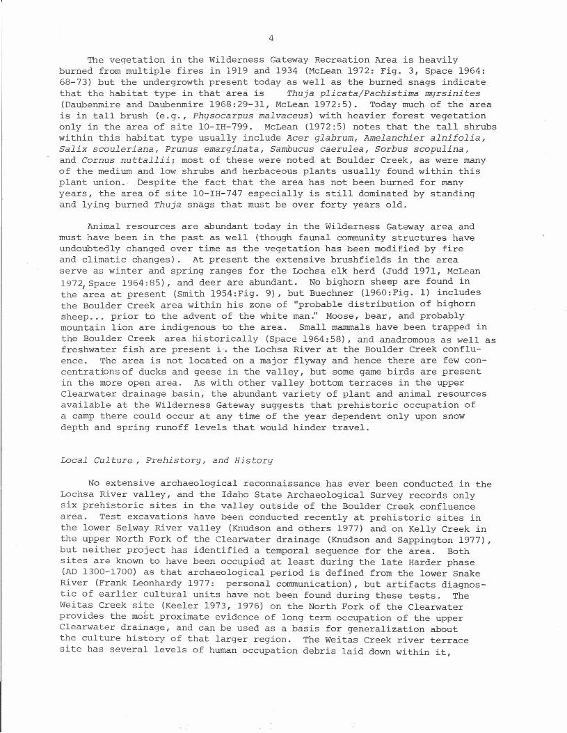
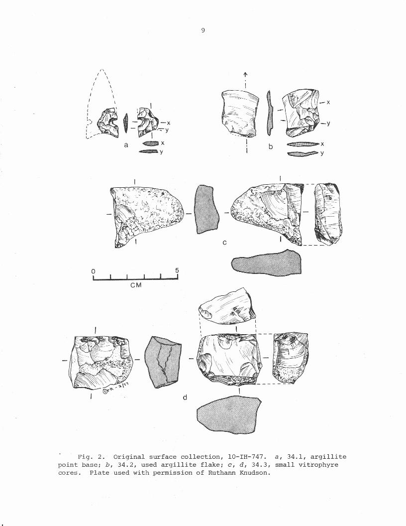
Art. 34.1: a basal corner fragment of a side-notched, concave base projectilepoint (Figs. la, 2a)
Length: greater than 18.0 mmWidth: greater than 13.0 mmThickness: 3.0 mm at breakWeight: greater than 0.6 g
Material: Argillite; dark grey under a light patina of light yellow-brown to yellow (lOYR 6/4-7/6); no evidence of annealing or burn-ing
Production technology: Preform and Stage 4 thinning flaking not appar-ent; Stage 5 edging by sequential, flat, bifacial flakes 3-4 mmwide and 5 mm long, plus smaller flat trimming flakes to shapecorner and notches; no edge grinding, and very straight thinedges on the short remnant
Tool units: Single remnant corner of the point indicates that thepiece was flaked to shape a shaft with a concave base and smalllateral notches set close to the base
Provenience: 10-IH-747, surface collection made by Hudson and Arvish,1976
Art. 15.1: a nearly complete projectile point, corner-notched to tangedwith incurved lateral edges and a long slender bifacially flaked tip(Fig. Ib)
Length: greater than 40.0 romwidth: 24.0 mm at shouldersThickness: 5.3 mm just above the haftWeight: greater than 16.0 g
Material: Chert: pinkish white to pinkish grey (7.5YR 8-7/2); slightluster and color may indicate annealing; no evidence of burning
Production technology: Preform and stage 4 thinning flaking not appar-ent; bifacial, very controlled and usually sequential slightlydiagonal Stage 5 edging scars that meet at an irregular flat midline;
8
Fig. 1. Bifacially worked stone tools, Boulder Creek area. a, point frag-ment 34.1 [lO-IH-747]; b, point 15.1 [lO-IH-747]; c, biface 4.2 [lO-IH-799]; d,biface fragment 4.2 [lO-IH-747]; e, biface fragment 6.1 [lO-IH-799]; f, bifacelateral edge fragment 27.2 [lO-IH-747].
I'\\\\\\\
\ \~'IW~ f· ., " -X
- -7"yI
ff
((
IIIIII0)
a
9
oI I IeM
5I
l'
I
b
c
d
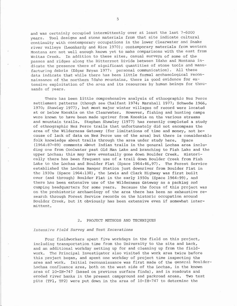
Fig. 2. Original surface collection, lO-IH-747.point base; b, 34.2, used argillite flake; c, a, 34.3,cores. Plate used with permission of Ruthann Knudson.
a, 34.1, argillitesmall vitrophyre
10
base worked in the same way but more shaping evident; no edgegrinding or scrubbing
Tool units: Lateral edges are slightly more than 36 mm long, have aproduction and fine angle of 35°, and are 2.0 mm thick 0.5 cmfrom the edge; the basal area has deep corner notches set intothe base so as to leave a "tang" at the base, as if for hafting
Provenience: 10-IH-747, surface collection made by David Rice
Bifaees (5)
Art. 4.2: a complete biface with a generalized pointed rectanguloid shape(Fig. Lc )
Length: 48.0 mmWidth: 26.4 mm, near the proximal endThickness: 8.0 mm near midsectionWeight: greater than 11.1 g
Material: Cherty argillite? (looks like fine grained argillite, butwith a higher silica content in one corner); dark blue-purplewith bluish grey (ca. 7.5B 5/1) and bits of dusky red (lOR 3/2)in the more siliceous segment, all with a slight patina of dif-fused greyish yellow; no evidence of annealing, and probably notburned
Production technology: Preform not apparent; State 4 thinning evidencedby bifacial irregularly broad flat scars from all edges with morepronounced midline on the dorsal face; apparently Stage 5 edging toremove irregularities only, and no final edge grinding
Tool units: Distal tip is 60° wide, with a production angle of 32°, anedge strength at 0.5 cm of 2.8 mm and 6.4 mm at 1.0 cm from edge;lateral edges are irregular in fine profile and plan, with an aver-age production angle of 33° and fine angle of 49°, an edge strengthof 5.0 mm at 0.5 cm and 6.0 rom at 1.0 cm from the edge
Provenience: 10-IH-799, Test Pit 3, level 4 (30 cm to gravel)
Art. 4.2: a basal fragment of a biface; drop-shaped? (Fig. Id)
Length: greater than 40.5 romWidth: slightly greater than 24.0 romThickness: 7.5 romWeight: greater than 6.8 g
Material: Argillite; dark grey with a light yellowish brown (lOYR 6/4)patina; no evidence of annealing or burning
Production technology: Dorsal face evinces an original secondary flakescar suggesting that the preform was a flake rather than core, butno other primary data; Stage 4 thinning shown by flat scars 12-15 rom
11
wide and long and frequently hinged, irregularly oriented; appearsto be very pragmatic thinning and edging, taking off one platformand setting up new platforms as one works around the edge; no ba-sal grinding but appears broken in manufacture (snap break)
Tool units: One lateral edge appears nearly finished, being fairlyregular in plan though still slightly sinuous in profile; has aproduction angle of 34°
Provenience: 10-IH-747, Test Pit 1, level 4 (15-20 cm)
Art. 6.1: basal section of biface (Fig. Ie)
Length: greater than 28.0 mmWidth: 28.0 mm at distal breakThickness: 7.9 mm at distal breakWeight: greater than 6.6 g
Material: Chert; reddish blue to very dusky red (lOR 2/1-2) withshading to dusky red (lOR 3/4) and touch of dark red (lOR 3/6);probably not annealed (color and luster appear natural); someevidence of burning in the incipient potlid cracks
Production technology: Preform not apparent; Stage 4 thinning scarsare up to 15 mm wide, 22 mm long, and may run across the pieceto leave a very thin cross-section; Stage 5 edging is apparentlyunifacial (LIVe, L2Do) and only to remove edge irregularities;no edge grinding
Tool units: Lateral edge at the distal break has a production angleof 42°, an edge strength at 0.5 cm of 5.0 mm
Provenience: 10-IH-799, surface of Area A near Test Pit 3
Art. 27.2: lateral edge fragment of a biface (Fig. If)
Length: greater than 25.0 mmWidth: greater than 11.9 mmThickness: greater than 5.6 mmWeight: greater than 1.7 g
Material: Vitrophyre, opaque with phenocrysts; very dark greenishgrey (5G 3/1); no evidence of annealing or burning
Production technology: Preform and Stage 4 thinning not apparent;Stage 5 edging with bifacial, somewhat abrupt (5-9 mm long, 4-5mm wide) flakes often oblique to the edge; strongly angled edgewith an apparently flatter midline area
Tool units: Edge has a production angle of 61°, an edge strength of6.5 mm at 0.5 cm from the edge
Provenience: 10-IH-747, Test Pit 2, level 1 (0-10 cm)
12
Art. 6.1.1: biface gone wrong!
Length: greater than 38.0 romWidth: greater than 31.0 romThickness: greater than 13.6 romWeight: greater than 16.4 g
Material: Chert; very dusky red (lOR 2-3/2); luster is probably natur-al, hence no evidence of annealing or burning
Produc~ion technology: Very irregular Stage 3/4 shaping and thinning, scars are bifacial, with crude abrupt and hinged edging only;
snap break, then subsequent burination of the piece with someplatform preparation (very tiny irregularly spaced spalls offedge) or else minor use of the lateral edge
Tool units: Probably none, if edge modification is from platform pre-paration; possible light crusmngon the snapped edge near the bur-ination appears to be fortuitous
Provenience: 10-IH-799, Area A near Test Pit 3
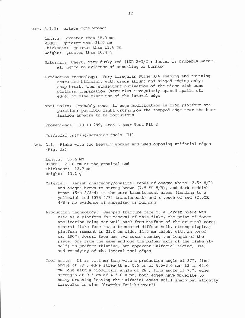
unifacial cutting/scraping tools (11)
Art. 2.1: Flake with two heavily worked and used opposing unifacial edges(Fig. 3a)
Length: 56.4 romWidth: 23.0 rom at the proximal endThickness: 12.7 romWeight: 13.1 g
Material: Kamiah chalcedony/opalite; bands of opaque white (2.5Y 8/1)and opaque brown to strong brown (7.5 YR 5/5), and dark reddishbrown (5YR 3/3-4) in the more transluscent areas (tending to ayellowish red [5YR 4/8] transluscent) and a touch of red (2.5YR4/8); no evidence of annealing or burning
Production technology: Snapped fracture face of a larger piece wasused as a platform for removal of this flake, the point of forceapplication being set well back from the face of the original core;ventral flake face has a truncated diffuse bulb, strong ripples;platform remnant is 21.0 rom wide, 11.5 rom thick, with an ~ ofca. 190°; dorsal face has two scars running the length of thepiece, one from the same and one the bulbar axis of the flake it-self; no preform thinning, but apparent unifacial edging, use,and re-edging of the lateral tool edges
Tool units: Ll is 51.1 rom long with a production angle of 37°, fineangle of 79°, edge strength at 0.5 cm of 6.5-8.0 rom; L2 is 45.0rom long with a production angle of 28°, fine angle of 77°, edgestrength at 0.5 cm of 4.5-6.0 rom; both edges have moderate toheavy crushing leaving the unifacial edges still sharp but sli9htlyirre~ular in plan (draw-knife-like wear?)
13
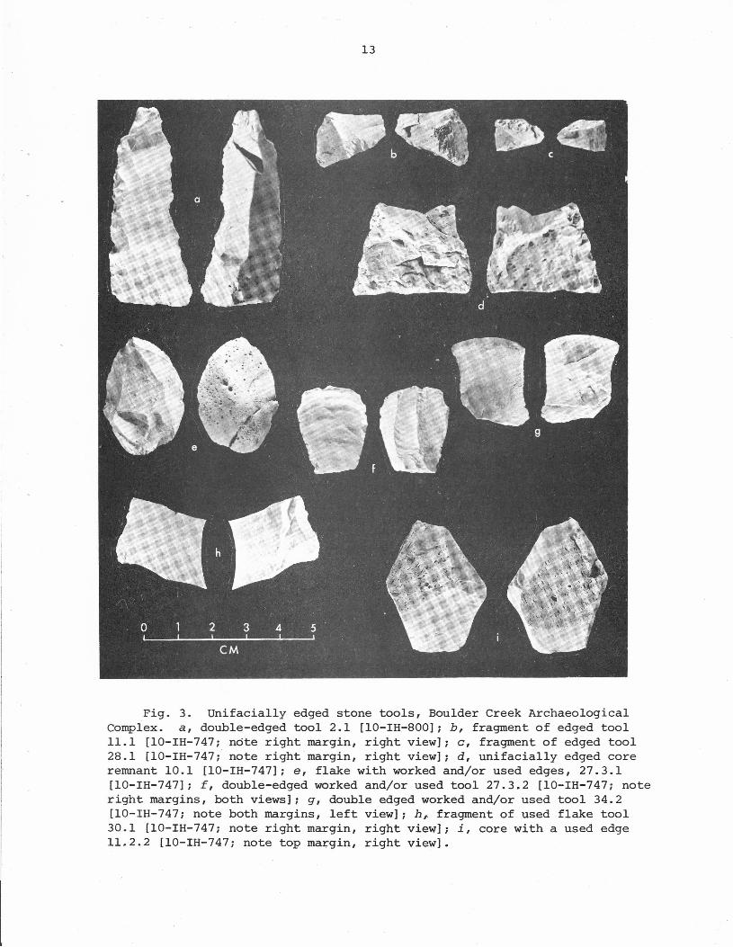
Fig. 3. Unifacially edged stone tools, Boulder Creek ArchaeologicalComplex. a, double-edged tool 2.1 [10-IH-800]; b, fragment of edged tool11.1 [10-IH-747; note right margin, right view]; c, fragment of edged tool28.1 [10-IH-747; note right margin, right view]; d, unifacially edged coreremnant 10.1 [10-IH-747]; e, flake with worked and/or used edges, 27.3.1[10-IH-747]; f, double-edged worked and/or used tool 27.3.2 [10-IH-747; noteright margins, both views]; g, double edged worked and/or used tool 34.2[10-IH-747; note both margins, left view]; h, fragment of used flake tool30.1 [10-IH-747; note right margin, right view]; i, core with a used edge11.2.2 [10-IH-747; note top margin, right view].
14
Provenience: 10-IH-800, roadcut erosion
Art. 31.1.1: unifacial tool fragment, perhaps a "classic" endscraper bitif not spalled deeply in center of arc
Length: greater than 27.0 romWidth: greater than 20.2 mmThickness: greater than 11.5 rnmWeight: greater than 3.9 g
Mate~ial: Vitrophyre; light olive grey to pale olive (5Y 6/2-3); noevidence of annealing or burning
Production technology: Ventral surface is either cortex or else a veryflat weathered flake surface; dorsal face has some very irregularcortex with Stage 5 edging all around the edge; edging flakes ir-regular (from 3.0 mm wide x 5.0 mm long to 8.0 mm wide x 9.0 romlong) with no real pattern
Tool Units: Edges very abraded (material very fragile) with a fewventral spalls; production angle of about 400
Provenience: 10-IH-747, Test Pit 2, levelS (40-50 cm)
Art. 11.1: fragment of a unifacially worked edge (Fig. 3b)
Length: greater than 18.0 mmwidth: greater than 21.5 mmThickness: greater than 6.0 mmWeight: greater than 19.0 mm
Material: Vitrophyre with phenocrysts; opaque very dark greenish grey(5G 3/1); no evidence of annealing or burning
Production technology: Secondary flake apparently, with platform rem-nant broken off; unifacial Stage 5 edging by flat flakes 3.5 mmwide and 4.5 mm long leaving a very sharp edge; perhaps broken(snap) in production?
Tool units: Probably not actually used, with a production angle of460 and an edge strength at 0.5 cm of 4.5 mm
Provenience:10-IH-747, Test Pit 1, level 11 (50-55 em)
Art. 28.1: fragment of a unifacially worked edge (Fig. 3c)
Length: greater than 9.0 mmWidth: greater than 14.5 mmThickness: greater than 4.5 romWeight: greater than 0.5 g
Material: (Kamiah?) opal/chalcedony; strong brown (7.5YR 5/6) opaquein the more trans Ius cent part, otherwise very pale brown to yel-low (lOYR 7/4-6) opaque; no evidence of heat treatment or burning
15
Production technology: Preform apparently a secondary flake thoughorientation not known; Stage 5 unifacial edging with scars moder-ately curved onto the face and averaging 3.0 rom wide and 5.0 romlong; two intersecting fractures appear to be initiated in bending,terminating in feathers
Tool units: Small edge fragment has a production angle of 40° and anedge strength at 0.5 cm of 4.0 rom
Provenience: 10-IH-747, Test pit 2, level 3 (20-30 cm)
Art. 10.1: battered piece with a single unifacial working edge; scraper?(Fig. 3d)
Length: 26.0 rom, parallel to working edgeWidth: 34.0 rom, perpendicular to working edgeThickness: 14.0 rom near broken endWeight: 20.0 g
Material: Vitrophyre with an edge that crumbles easily, a smoothedbrick-like cortex, and phenocrysts; light olive grey to paleolive (5Y 6/2-3); no evidence of annealing or burning
Production technology: Stage 2 core remnant with cortex remaining;unifacial Stage 5 edging on one edge, with scars about 8 rom wideand 7 rom long, moderately deep with crushing inside the scars atthe tool edge (near edging scars proximal initiation)
Tool units: Lateral edge is greater than 26.0 rom long (piece isbroken across the worked edge), with a production angle of 64°,an edge strength at 0.5 cm of 6.5.rom, and no obvious wear damage
Provenience: 10-IH-747, Test Pit 1, level 10 (45-50 cm)
Art. 27.3.1: flake with worked and/or used edge; scraper? (Fig. 3e)
Length: 34.2 rom on long axisWidth: 23.6 rom at midsectionThickness: 9.9 rom at midsectionWeight: 6.8 g
Material: Vitrophyre; very dark greenish grey (5G 3/1); no evidence ofannealing or burning
Production technology: Primary decortication spall (Stage 2 flake)with a few Stage 3 spalls off it, then some unifacial irregularshort (3 rom long) Stage 5 flakes off one short segment of edge
Tool units: Ll has use spalls only, unifacial, 2 rom or less long,along a 12 rom long edge segment with a production angle of 50°and an edge strength at 0.5 cm of 5.0 rom; L2 has edging and somefine edge collapse along a 20.0 rom long edge, with a productionangle of 50° and an edge strength at 0.5 cm of 4.4 rom
16
Provenience: 10-IH-747, Test Pit 2, level 1 (0-10 cm)
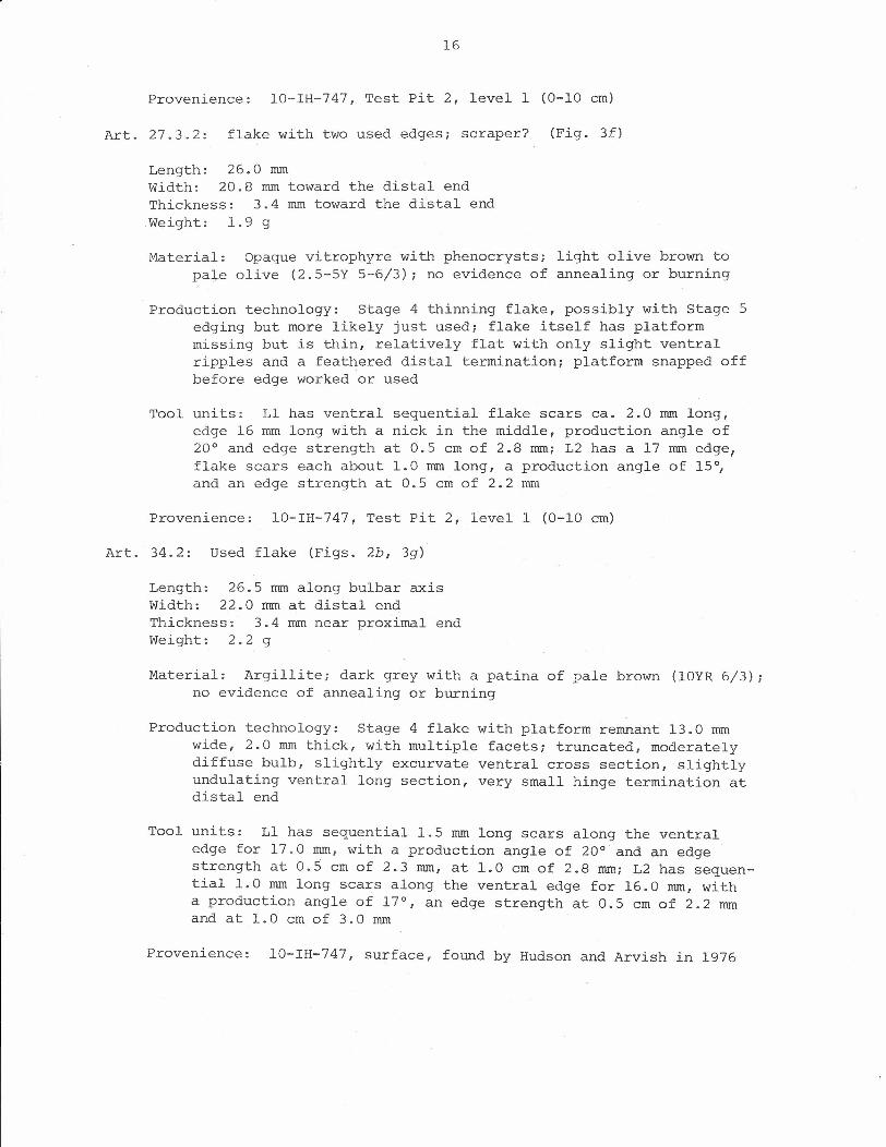
Art. 27.3.2: flake with two used edges; scraper? (Fig. 3f)
Length: 26.0 mmWidth: 20.8 mm toward the distal endThickness: 3.4 mm toward the distal endWeight: 1.9 g
Material: Opaque vitrophyre with phenocrysts; light olive brown topa~e olive (2.5-5Y 5-6/3); no evidence of annealing or burning
Production technology: Stage 4.thinning flake, possibly with Stage 5edging but more likely just used; flake itself has platformmissing but is thin, relatively flat with only slight ventralripples and a feathered distal termination; platform snapped offbefore edge worked or used
Tool units: Ll has ventral sequential flake scars ca. 2.0 mm long,edge 16 mm long with a nick in the middle, production angle of20° and edge strength at 0.5 cm of 2.8 mm; L2 has a 17 mm edge,flake scars each about 1.0 mm long, a production angle of 15°,and an edge strength at 0.5 cm of 2.2 mm
Provenience: 10-IH-747, Test Pit 2, level 1 (0-10 cm)
Art. 34.2: Used flake (Figs. 2b, 3g)
Length: 26.5 mm along bulbar axisWidth: 22.0 mm at distal endThickness: 3.4 mm near proximal endWeight: 2.2 g
Material: Argillite; dark grey with a patina of pale brown (lOYR 6/3);no evidence of annealing or burning
Production technology: Stage 4 flake with platform remnant 13.0 mmwide, 2.0 mm thick, with multiple facets; truncated, moderatelydiffuse bulb, slightly excurvate ventral cross section, slightlyundulating ventral long section, very small hinge termination atdistal end
Tool units: Ll has sequential 1.5 mm long scars along the ventraledge for 17.0 mm, with a production angle of 20° and an edgestrength at 0.5 cm of 2.3 mm, at 1.0 cm of 2.8 mm; L2 has sequen-tial 1.0 mm long scars along the ventral edge for 16.0 mm, witha production angle of 17°, an edge strength at 0.5 cm of 2.2 mmand at 1.0 cm of 3.0 mm
Provenience: 10-IH-747, surface, found by Hudson and Arvish in 1976
17
Art. 30.1: used thin flake fragment (Fig. 3h)
Length: greater than 20.5 rom along bulbar axiswidth: greater than 29.1 romThickness: greater than 2.8 romWeight: greater than 2.3 rom
Material: Chalcedony; very pale brown (lOYR 7/3) opaque with blebsof white (lOYR 8/3); more pink (7.5YR 8/4) transluscent; no evi-dence of annealing or burning
Production technology: Stage 3 thinning flake midsection with veryflat cross and lateral sections, no edge work
Tool units: Lateral edge fragment with 1.0 rom long snapped flakes("nibbling") along the dorsal face, a production angle of 15°,a fine angle of 55°-70°, and an edge strength at 0.5 cm of 2.0 rom
Provenience: 10-IH-747, Test Pit 2, level 4 (30-40 cm)
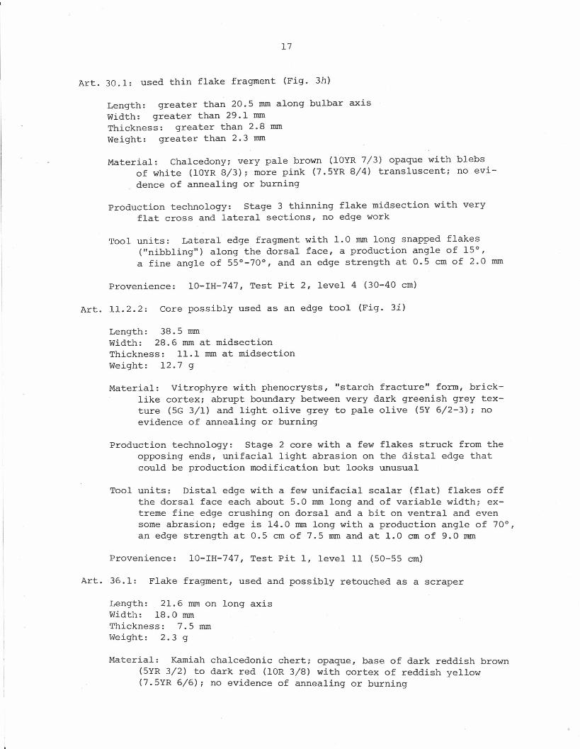
Art. 11.2.2: Core possibly used as an edge tool (Fig. 3i)
Length: 38.5 romWidth: 28.6 rom at midsectionThickness: 11.1 rom at midsectionWeight: 12.7 g
Material: Vitrophyre with phenocrysts, "starch fracture" form, brick-like cortex; abrupt boundary between very dark greenish grey tex-ture (5G 3/1) and light olive grey to pale olive (5Y 6/2-3); noevidence of annealing or burning
Production technology: Stage 2 core with a few flakes struck from theopposing ends, unifacial light abrasion on the distal edge thatcould be production modification but looks unusual
Tool units: Distal edge with a few unifacial scalar (flat) flakes offthe dorsal face each about 5.0 rom long and of variable width; ex-treme fine edge crushing on dorsal and a bit on ventral and evensome abrasion; edge is 14.0 rom long with a production angle of 70°,an edge strength at 0.5 cm of 7.5 rom and at 1.0 cm of 9.0 rom
Provenience: 10-IH-747, Test Pit I, level 11 (50-55 cm)
Art. 36.1: Flake fragment, used and possibly retouched as a scraper
Length: 21.6 rom on long axisWidth: 18.0 romThickness: 7.5 romWeight: 2.3 g
Material: Kamiah chalcedonic chert; opaque, base of dark reddish brown(5YR 3/2) to dark red (lOR 3/8) with cortex of reddish yellow(7.5YR 6/6); no evidence of annealing or burning
18
Production technology: Secondary flake with platform remnant broken off;1 major dorsal scar with axis perpendicular to that of the flakeitself, with a few steep Stage 3-4 spalls off the lateral edge;~ge 5 edging flakes are 2.0 rom wide and long, a row of barelycontiguous scars around the dorsal face edge for a short distance;ventral flake face smooth, relatively flat
Tool units: Ll is 15.0 rom long with Stage 5 edging scars, a productionangle of 55°, a fine angle of 70°, and an edge strength at 0.5 cmof 6.3 rom; L2 has irregular 2.0 rom wide x 0.5 rom long spallsaround dorsal edge and a few off the ventral face for a totallength of 10.0 rom, a production angle of 25°, a fine angle of 55°,and an edge strength at 0.5 cm of 2.5 rom
Provenience: 10-IH-747, Test Pit 1, level 12 (55-60 cm)
Chopper/chopping tools (4)
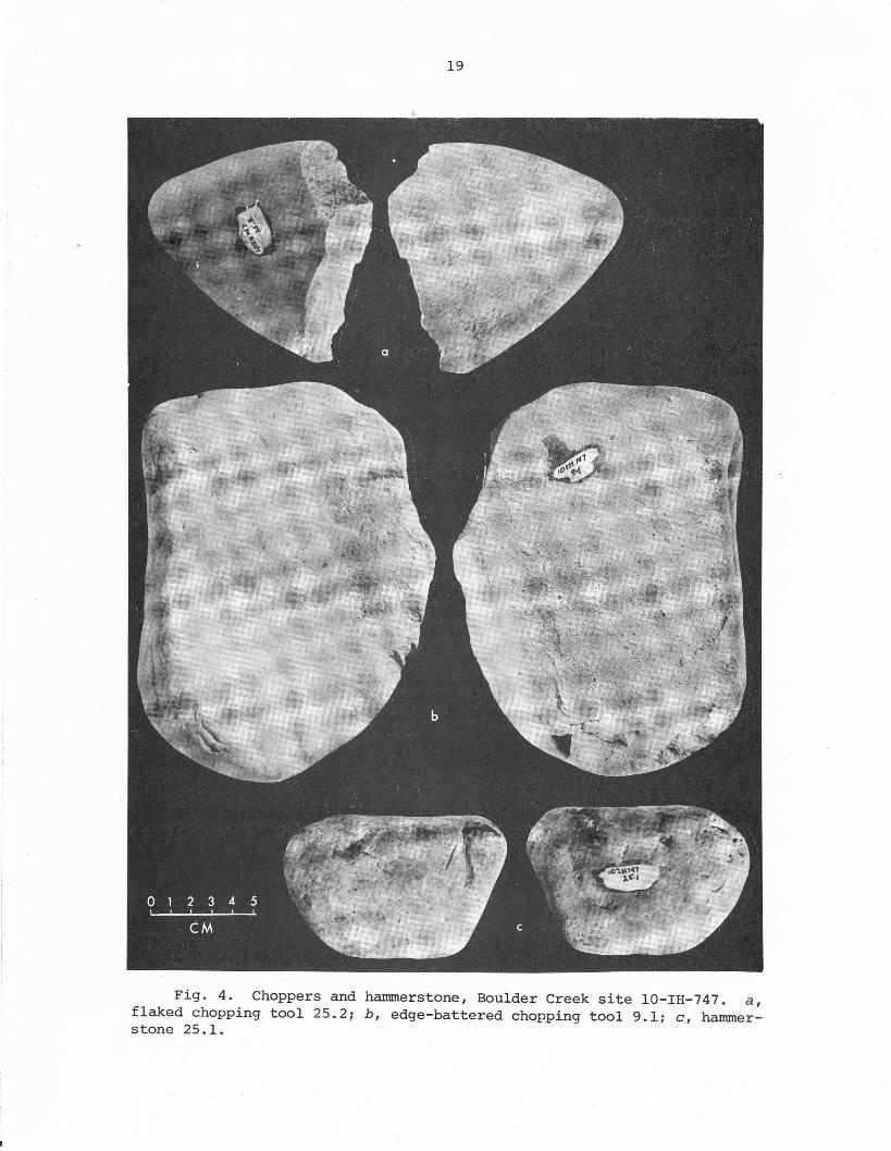
Art. 25.2: Cobble with flaked edge (Fig. 4a)
Length: 112.2 romWidth: 108.2 romThickness: 56.0 romWeight: 828.3 g
Material: Fine-grained granitic with tough surface; light brownishgrey (2.5Y 6/2) in a grey (N 6/0) groundmass; no evidence ofannealing or burning
Production technology: Stage 2 flakes removed at one end, 3-4 largeflake scars still evident; no other modification
Tool unit: Single edge with a production angle of about 60°, withvery slight rounding and battering on the flaked edge
Provenience: 10-IH-747, Test Pit 2, level 2 (10-20 cm)
Art. 36.2: Cobble with battered end edge; smaller chopper
Length: 89.5 romWidth: 56.2 romThickness: 33.8 romWeight: 279.4 g
Material: Fine-grained granitic with tough surface; grey (N 6/0) basewith diffuse patina of brownish yellow (lOYR 6/6); no evidence ofannealing or burning
Production technology: No modification of cobble as tool production
Tool unit: End edge has a few large hinged flake scars, especially offthe dorsal face and a few off of the ventral side toward the cornerof the piece; the production angle is about 75° overall, with anangle of 58° between the ventral and hinged flake scar surfaces;edge length is about 45.0 rom, with heavy crushing on the edgecorner especially on the dorsal face
19
Fig. 4. Choppers and hammerstone, Boulder Creek site lO-IH-747. a,flaked chopping tool 25.2; b, edge-battered chopping tool 9.1; c, hammer-stone 25.1.
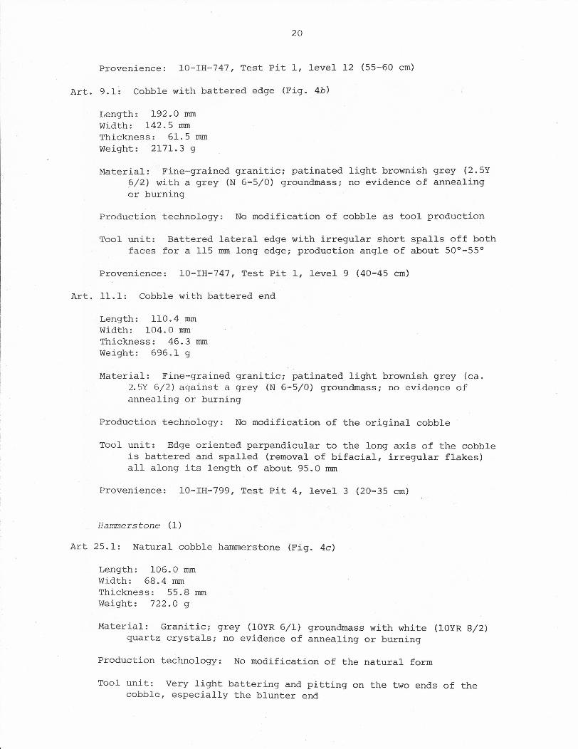
20
Provenience: 10-IH-747, Test Pit 1, level 12 (55-60 cm)
Art. 9.1: Cobble with battered edge (Fig. 4b)
Length: 192.0 mmWidth: 142.5 mmThickness: 61.5 mmWeight: 2171.3 g
Material: Fine-grained granitic; patinated light brownish grey (2.5Yp/z) with a grey (N 6-5/0) groundmass; no evidence of annealingor burning
Production technology: No modification of cobble as tool production
Tool unit: Battered lateral edge with irregular short spalls off bothfaces for a 115 mm long edge; production angle of about 500-550
Provenience: 10-IH-747, Test Pit 1, level 9 (40-45 cm)
Art. 11.1: Cobble with battered end
Length: 110.4 mmWidth: 104.0 mmThickness: 46.3 mmWeight: 696.1 g
Material: Fine-grained granitic; patinated light brownish grey (ca.2.5Y 6/2) against a grey (N 6-5/0) groundmass; no evidence ofannealing or burning
Production technology: No modification of the original cobble
Tool unit: Edge oriented perpendicular to the long axis of the cobbleis battered and spalled (removal of bifacial, irregular flakes)all along its length of about 95.0 mm
Provenience: 10-IH-799, Test Pit 4, level 3 (20-35 cm)
Hammerstone (1)
Art 25.1: Natural cobble hammers tone (Fig. 4c)
Length: 106.0 mmWidth: 68.4 mmThickness: 55.8 mmWeight: 722.0 g
Material: Granitic; grey (lOYR 6/1) groundmass with white (lOYR 8/2)quartz crystals; no evidence of annealing or burning
Production technology: No modification of the natural form
Tool unit: Very light battering and pitting on the two ends of thecobble, especially the blunter end
21
Provenience: 10-IH-747, Test Pit 2, level 2 (10-20 cm)
Grinding stone (1)
Art. 38.1: Natural boulder grinding or nether stone.
Length: 395.0 romWidth: 317.0 romThickness: 118.0 romWej-gnt: about 22 kg
Material: Fine-grained granitic with tough surface; no evidence ofannealing or burning
Production technology: No specific modification in order to shape theform is apparent
Tool unit: One face of this flattened boulder is very smoothed, forminga shallow trough, whereas the other face is rougher, more granularas if from natural erosion
Provenience: 10-IH-747, Test Pit 2, level 2 (10-20 cm)
Debitage (2070)
Cores (6)
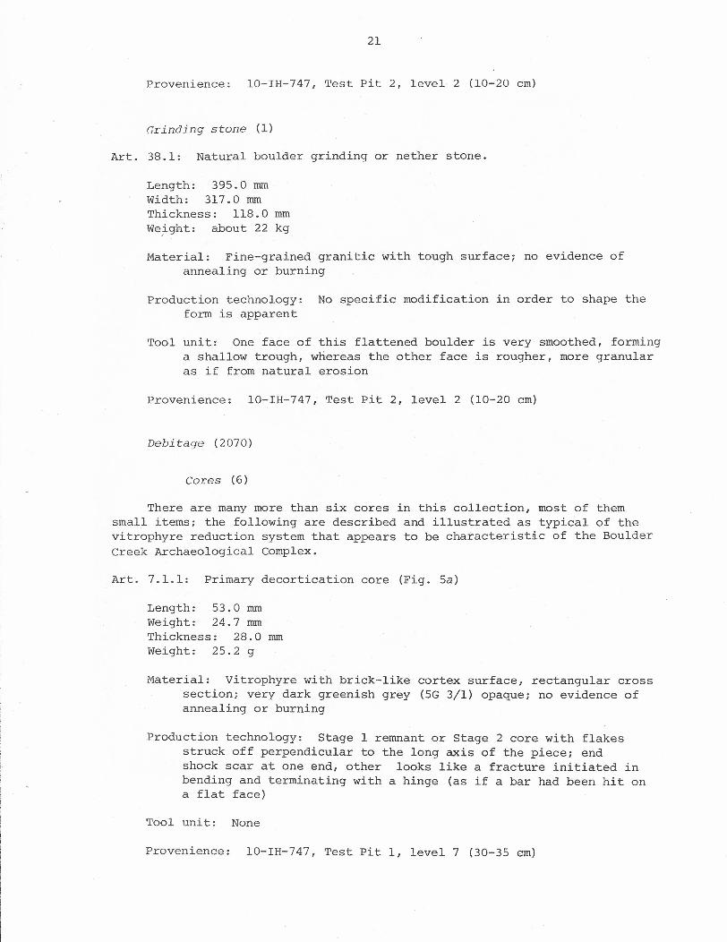
There are many more than six cores in this collection, most of themsmall items; the following are described and illustrated as typical of thevitrophyre reduction system that appears to be characteristic of the BoulderCreek Archaeological Complex.
Art. 7.1.1: Primary decortication core (Fig. 5a)
Length: 53.0 romWeight: 24.7 romThickness: 28.0 romWeight: 25.2 g
Material: Vitrophyre with brick-like cortex surface, rectangular crosssection; very dark greenish grey (5G 3/1) opaque; no evidence ofannealing or burning
Production technology: Stage 1 remnant or Stage 2 core with flakesstruck off perpendicular to the long axis of the piece; endshock scar at one end, other looks like a fracture initiated inbending and terminating with a hinge (as if a bar had been hit ona flat face)
Tool unit: None
Provenience: 10-IH-747, Test Pit 1, level 7 (30-35 em)
22
Fig. 5. Vitrophyre cores or tabular core ends from the Boulder CreekArchaeological Complex. a, core 7.!.1 [lO-IH--747]; b, core 33.2.1 withsnapped end [10-IH-747]; c, tabular core end 2.1.1 [10-IH-747]; d, core end30.3.1 [lO-IH-747]; e, tabular secondary flake 7.1 [lO-IH-799]; f, core 35.1[10-IH-747] .
23
Art. 33.2.1: Core with snapped end (Fig. 5b)
Length: 43.8 rom~vidth: 33.7 romThickness: 19.4 romWeight: 27.3 g
Material: Vitrophyre with brick-like cortex surface, phenocrysts,"starch fracture" shape; very dark greenish grey (5G 3.1); noevidence of annealing or burning
Production technology: Core with end fracture that appears to be ini-tiated in bending and terminate with a slight hinge
Tool unit: None
Provenience: 10-IH-747, Test Pit 2, level 7 (60-70 em)
Art. 2.1.1: Primary flake off end of nodule (Fig. 5c)
Length: 37.8 romWidth: 27.8 romThickness: 12.2 romWeight: 18.1 g
Material: Vitrophyre with flat brick-like surface, phenocrysts, 90°corners; very dark greenish grey (5G 3/1) evenly grading to asort of microdot mass of very dark greenish grey and olive(5Y 5/3); no evidence of annealing or burning
Production technology: Apparently a primary decortication flake offthe end of a larger nodule, with a snap fracture; Stage 2 remnant
Tool unit: Possibly some use modification off of one cortex/ventralflake edge, with very flat edge scars 4-5 rom wide and about 10 romlong; no pattern to these, though they are unifacial, and about1 rom "nibbling" occurs along edge; because of the fragile natureof this material, the modification is not convincing evidence of"use"
Provenience: 10-IH-747, Test Pit 1, level 2 (5-10 em)
Art. 30.3.1: Core or flake (Fig. 5d)
Length: 41.0 nunWidth: 40.0 nunThickness: 18.0 romWeight: 28.0 rom
Material: Vitrophyre with brick-like cortex surface, flow lines, pheno-crys t.sr very dark greenish grey (2.5-5G 3/1); no evidence ofannealing or burning
Production technology: Could be a core, perhaps split with bipolarforce, or else a flake with a weathered crevice between it and
24
the parent core so that when the core was hit this piece splitoff in sympathy
Tool unit: Not likely, because the edge is naturally fragile, butpossibly some dorsal unifacial edge "nibbling"
Provenience: 10-IH-747, Test Pit 2, level 4 (30-40 cm)
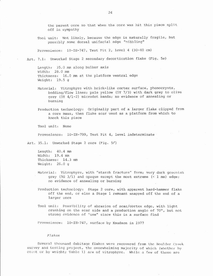
Art. 7.1: Unworked Stage 2 secondary decortication flake (Fig. 5e)
Leng~h~ 35.0 mm along bulbar axisWidth: 28.0 mmThickness: 16.0 mm at the platform ventral edgeWeight: 19.5 g
Material: Vitrophyre with brick-like cortex surface, phenocrysts,bedding/flow lines; pale yellow (5Y 7/3) with dark grey to olivegrey (5Y 4/1-2) microdot bands; no evidence of annealing orburning
Production technology:a core mass, thenknock this piece
Originally part of a larger flake clipped fromflake scar used as a platform from which to
Tool unit: None
Provenience: 10-IH-799, Test Pit 4, level indeterminate
Art. 35.1: Unworked Stage 2 core (Fig. 5f)
Length: 40.4 mmWidth: 19.4 mmThickness: 14.3 mmWeight: 26.0 g
Material: Vitrophyre, with "starch fracture" form; very dark greenishgrey (5G 3/1) and opaque except the most extreme « 1 mm) edge;no evidence of annealing or burning
Production technology: Stage 2 core, with apparent hard-hammer flakeoff the end, or else a Stage 1 remnant snapped off the end of alarger core
Tool unit: Possibility of abrasion of scar/cortex edge, with lightcrushing on the scar side and a production angle of 70°, but notstrong evidence of "use" since this is a surface find
Provenience: 10-IH-747, surface by Knudson in 1977
Flakes
Several thousand debitage flakes were recovered from the Boulder Creeksurvey and testing project, the overwhelming majority of which (whether bycount or by weight; Table 1) are of vitrophyre. While a few of these are
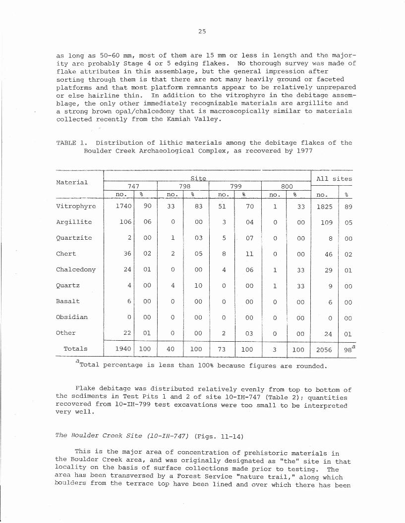
25
as long as 50-60 mm, most of them are 15 mm or less in length and the major-ity are probably Stage 4 or 5 edging flakes. No thorough survey was made offlake attributes in this assemblage, but the general impression aftersorting through them is that there are not many heavily ground or facetedplatforms and that most platform remnants appear to be relatively unpreparedor else hairline thin. In addition to the vitrophyre in the debitage assem-blage, the only other immediately recognizable materials are argillite anda strong brown opal/chalcedony that is macroscopically similar to materialscollected recently from the Kamiah Valley.
TABLE 1. Distribution of lithic materials among the debitage flakes of theBoulder Creek Archaeological Complex, as recovered by 1977
Site All sitesMaterial 798 799 800747no. % no. % no. % no. % no. %
Vitrophyre 1740 90 33 83 51 70 1 33 1825 89
Argillite 106 06 a 00 3 04 a 00 109 05
Quartzite 2 00 1 03 5 07 a 00 8 00
Chert 36 02 2 05 8 11 a 00 46 02
Chalcedony 24 01 a 00 4 06 1 33 29 01
Quartz 4 00 4 10 a 00 1 33 9 00
Basalt 6 00 a 00 a 00 a 00 6 00
Obsidian a 00 0 00 a 00 a 00 0 00
Other 22 01 0 00 2 03 a 00 24 01
Totals 1940 100 40 100 73 100 3 100 2056 98a
a Total percentage is less than 100% because figures are rounded.
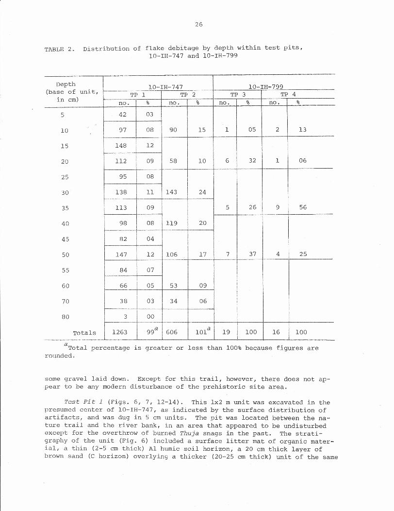
Flake debitage was distributed relatively evenly from top to bottom ofthe sediments in Test Pits 1 and 2 of site 10-IH-747 (Table 2); quantitiesrecovered from 10-IH-799 test excavations were too small to be interpretedvery well.
The Boulder Creek Site (lO-IH-747) (Figs. 11-14)
This is the major area of concentration of prehistoric materials inthe Boulder Creek area, and was originally designated as "the" site in thatlocality on the basis of surface collections made prior to testing. Thearea has been transversed by a Forest Service "nature trail," along whichboulders from the terrace top have been lined and over which there has been
26
TABLE 2. Distribution of flake debitage by depth within test pits,10-IH-747 and 10-IH-799
Depth 10-IH-747 10-IH-799(base of unit, TP 1 TP 2 TP 3 TP 4in em) no. % no. % no. % no. %
5 42 03e-
" 97 08 90 15 1 05 2 1310
15 148 12
20 112 09 58 10 6 32 1 06.-
25 95 08I
30 138 11 143 24
35 113 09 5 26 9 56
40 98 08 119 20
45 82 04
50 147 12 106 17 7 37 4 25_. --_.
55 84 07
60 66 05 53 09f---
70 38 03 34 06
80 3 00-- --
Totals 1263 99a 606 101a 19 100 16 100
aTotal percentage is greater or less than 100% because figures arerounded.
some gravel laid down. Except for this trail, however, there does not ap-pear to be any modern disturbance of the prehistoric site area.
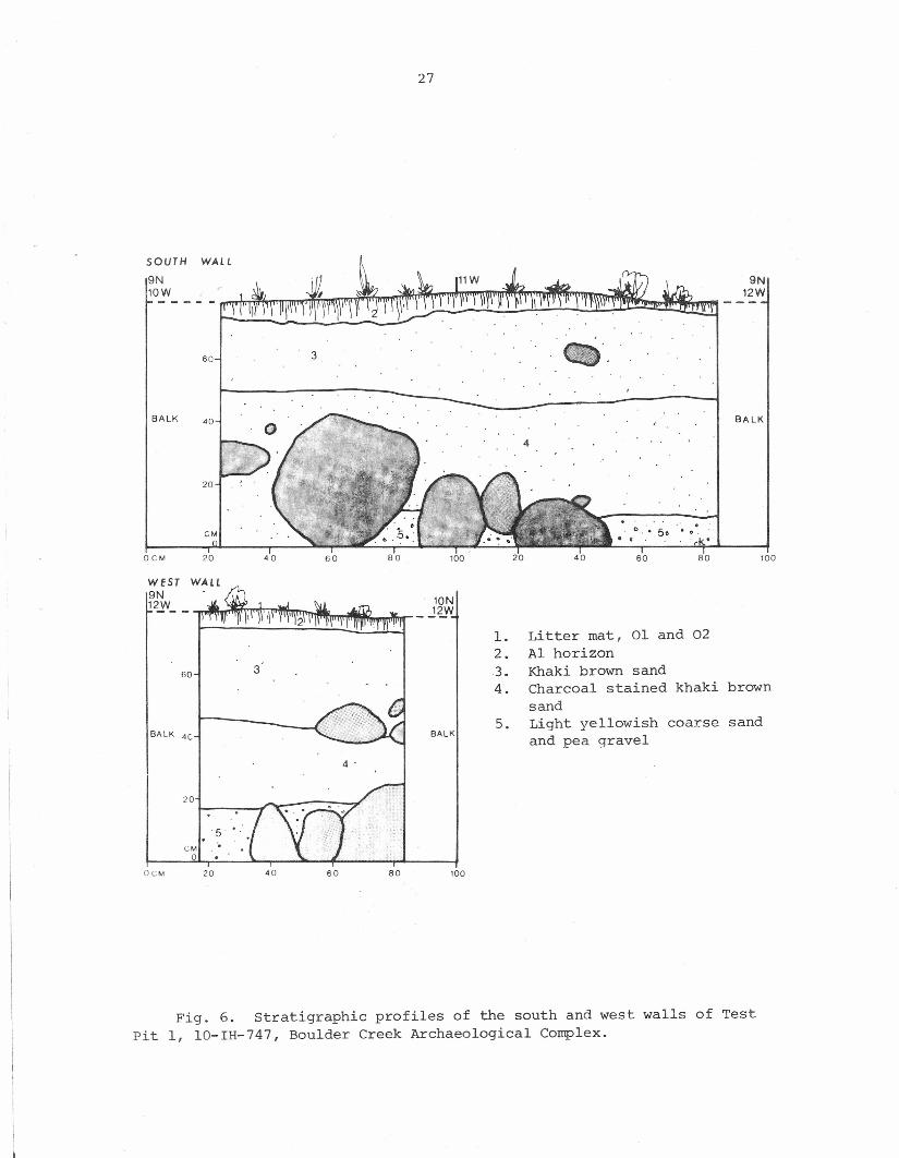
Test Pit 1 (Figs. 6, 7, 12-14). This lx2 m unit was excavated in thepresumed center of 10-IH-747, as indicated by the surface distribution ofartifacts, and was dug in 5 cm units. The pit was located between the na-ture trail and the river bank, in an area that appeared to be undisturbedexcept for the overthrow of burned Thuja snags in the past. The strati-graphy of the unit (Fig. 6) included a surface litter mat of organic mater-ial, a thin (2-5 cm thick) Al humic soil horizon, a 20 cm thick layer ofbrown sand (C horizon) overlying a thicker (20-25 cm thick) unit of the same
27
SOUTH WAll
9N
10!,- - - -l!1tT~rn~~m~rr~TI~~n!~!~~!Jl~~TIm~~~J~~~
oeM 20 40 60 80 100 20 40 60 80 100
WEST9N12jV__ lON
_J~Wl. Litter mat, 01 and 022. Al horizon
60 3 3. Khaki brown sand4. Charcoal stained khaki brown
sandBALK 4C
5. Light yellowish coarse sandBALK and pea gravel
20
5 .eM
0oeM 20 40 60 80 100
360
BALK 40
20
9N12W
BALK
Fig. 6. Stratigraphic profiles of the south and west walls of TestPit 1, lO-IH-747, Boulder Creek Archaeological Complex.
28
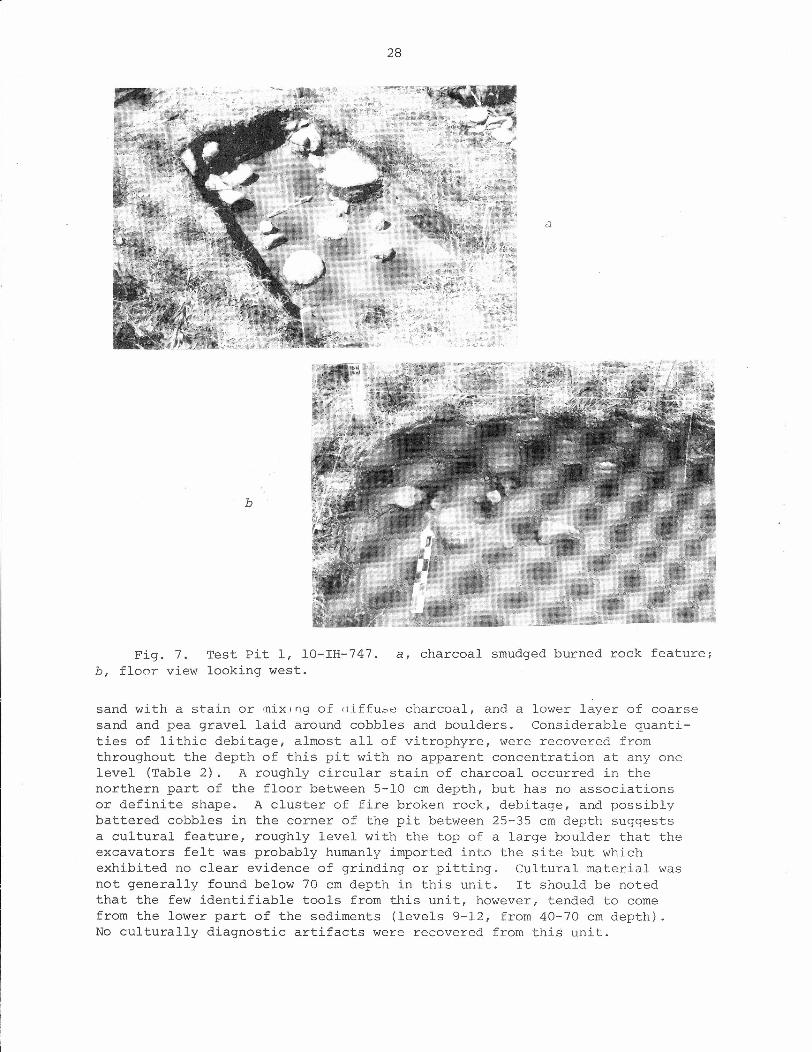
a
b
Fig. 7. Test pit 1, 10-IH-747. a, charcoal smudged burned rock feature;b, floor view looking west.
sand with a stain or mixJDg of (iiffu~e charcoal, and a lower layer of coarsesand and pea gravel laid around cobbles and boulders. Considerable quanti-ties of lithic debitage, almost all of vitrophyre, were recovered fromthroughout the depth of this pit with no apparent concentration at anyonelevel (Table 2). A roughly circular stain of charcoal occurred in thenorthern part of the floor between 5-10 cm depth, but has no associationsor definite shape. A cluster of fire broken rock, debitage, and possiblybattered cobbles in the corner of the pit between 25-35 cm depth suggestsa cultural feature, roughly level with the top of a large boulder that theexcavators felt was probably humanly imported into the site but whichexhibited no clear evidence of grinding or pitting. Cultural material wasnot generally found below 70 cm depth in this unit. It should be notedthat the few identifiable tools from this unit, however, tended to cornefrom the lower part of the sediments (levels 9-12, from 40-70 cm depth) .No culturally diagnostic artifacts were recovered from this unit.
29
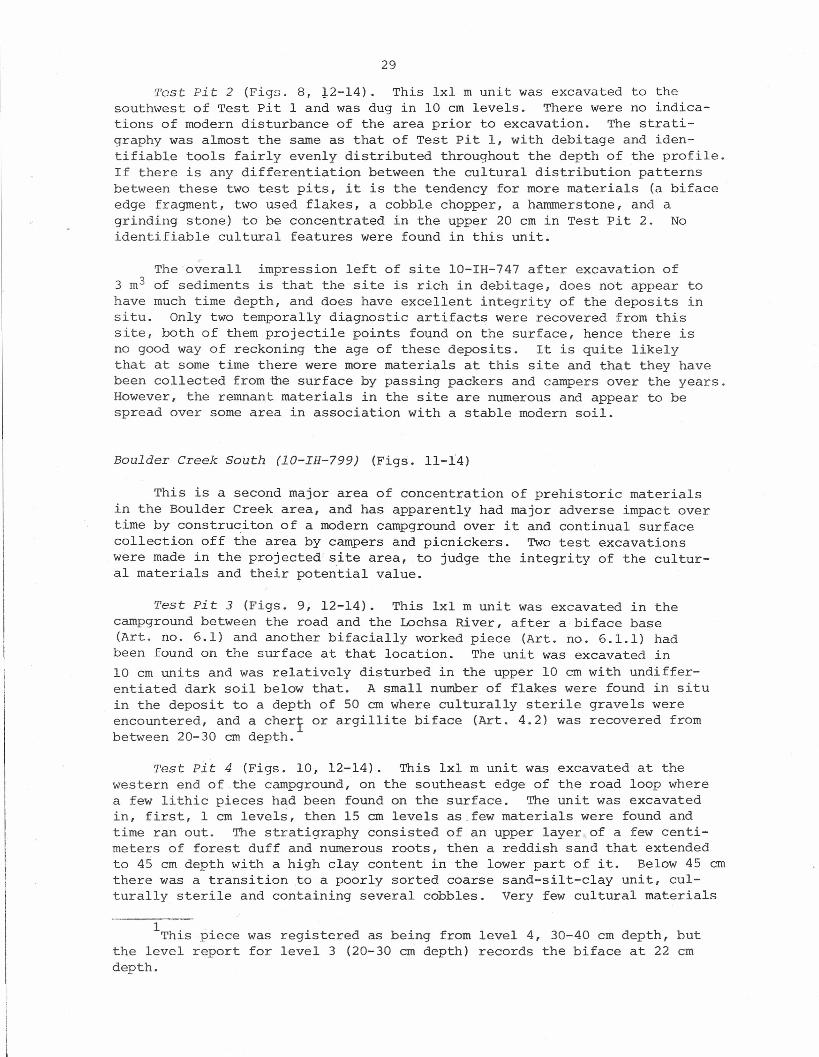
Test Pit 2 (Figs. 8, .l.2-l4). This lxl m unit was excavated to thesouthwest of Test Pit 1 and was dug in 10 cm levels. There were no indica-tions of modern disturbance of the area prior to excavation. The strati-graphy was almost the same as that of Test pit 1, with debitage and iden-tifiable tools fairly evenly distributed throughout the depth of the profile.If there is any differentiation between the cultural distribution patternsbetween these two test pits, it is the tendency for more materials (a bifaceedge fragment, two used flakes, a cobble chopper, a hammerstone, and agrinding stone) to be concentrated in the upper 20 cm in Test Pit 2. Noidentifiable cultural features were found in this unit.
The overall impression left of site 10-IH-747 after excavation of3 m3 of sediments is that the site is rich in debitage, does not appear tohave much time depth, and does have excellent integrity of the deposits insitu. Only two temporally diagnostic artifacts were recovered from thissite, both of them projectile points found on the surface, hence there isno good way of reckoning the age of these deposits. It is quite likelythat at some time there were more materials at this site and that they havebeen collected fromfue surface by passing packers and campers over the years.However, the remnant materials in the site are numerous and appear to bespread over some area in association with a stable modern soil.
Boulder Creek South (lO-IH-799) (Figs. 11-14)
This is a second major area of concentration of prehistoric materialsin the Boulder Creek area, and has apparently had major adverse impact overtime by construciton of a modern campground over it and continual surfacecollection off the area by campers and picnickers. Two test excavationswere made in the projected site area, to judge the integrity of the cultur-al materials and their potential value.
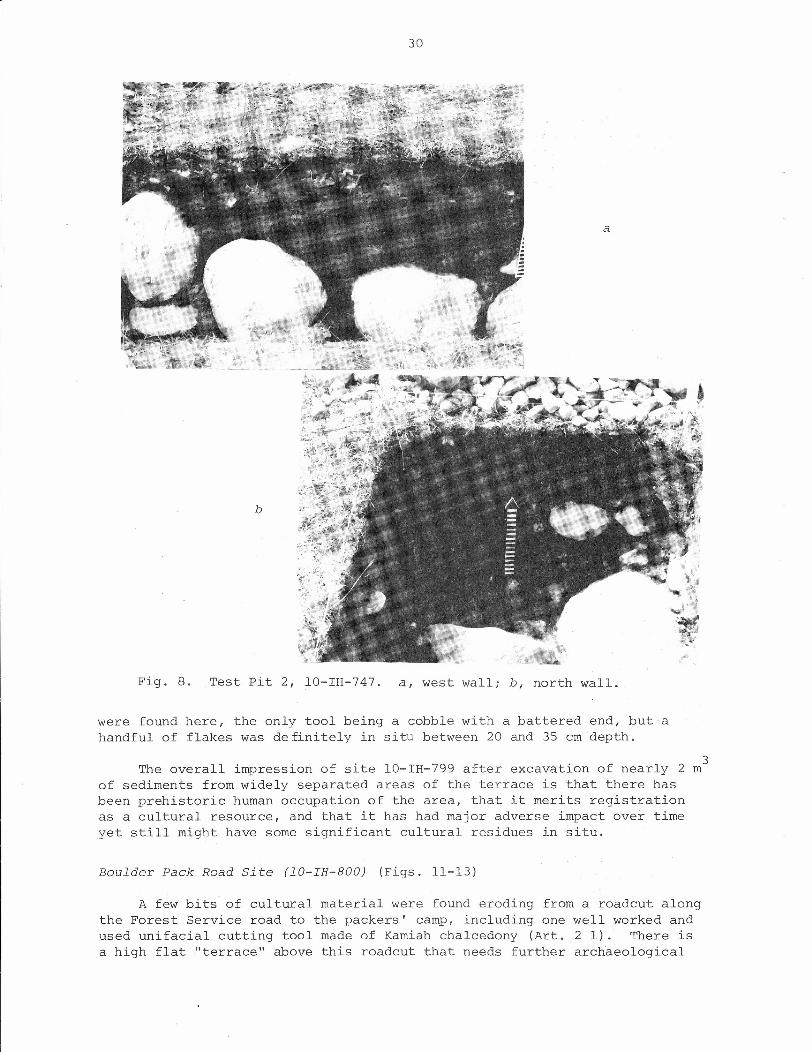
Test Pit 3 (Figs. 9, 12-14). This lxl m unit was excavated in thecampground between the road and the Lochsa River, after a biface base(Art. no ..6.1) and another bifacially worked piece (Art. no. 6.1.1) hadbeen found on the surface at that location. The unit was excavated in10 cm units and was relatively disturbed in the upper 10 cm with undiffer-entiated dark soil below that. A small number of flakes were found in situin the deposit to a depth of 50 cm where culturally sterile gravels wereencountered, and a chert or argillite biface (Art. 4.2) was recovered frombetween 20-30 cm depth.
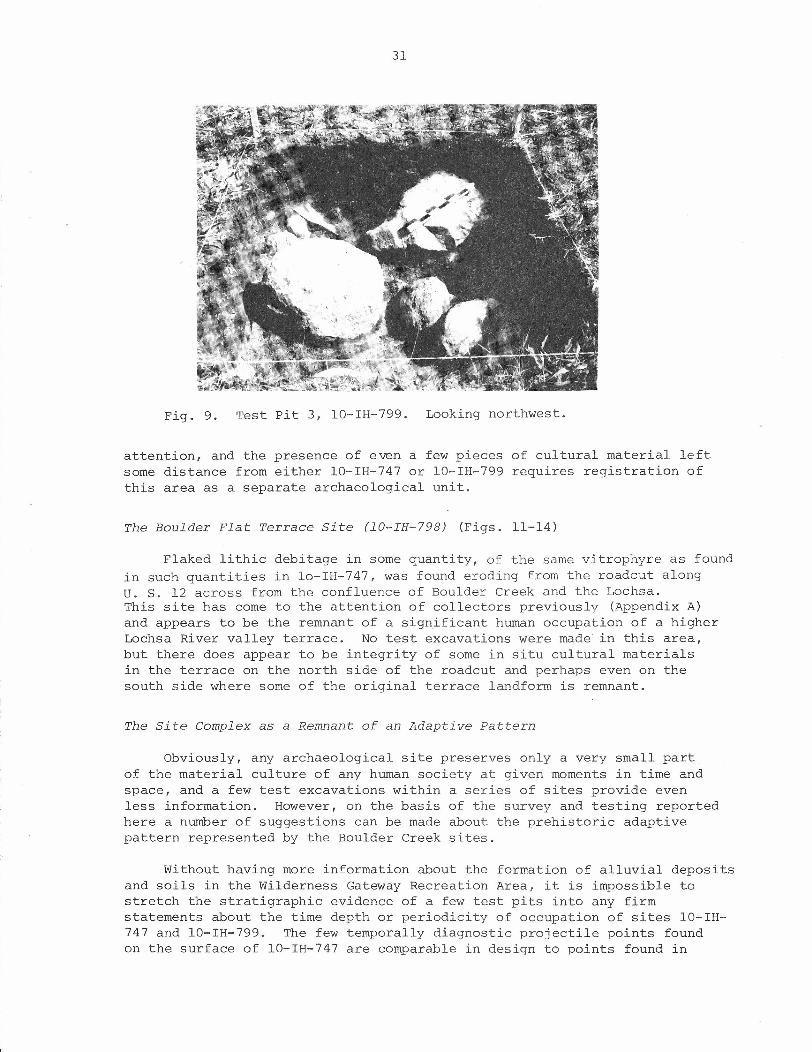
Test pit 4 (Figs. 10, 12-14). This lxl m unit was excavated at thewestern end of the campground, on the southeast edge of the road loop wherea few lithic pieces had been found on the surface. The unit was excavatedin, first, 1 cm levels, then 15 cm levels as few materials were found andtime ran out. The stratigraphy consisted of an upper layer of a few centi-meters of forest duff and numerous roots, then a reddish sand that extendedto 45 cm depth with a high clay content in the lower part of it. Below 45 cmthere was a transition to a poorly sorted coarse sand-silt-clay unit, cul-turally sterile and containing several cobbles. Very few cultural materials
1 hi "T 1S p1ecethe level reportdepth.
was registered as being from level 4, 30-40 cm depth, butfor level 3 (20-30 cm depth) records the biface at 22 cm
30
Fig. 8. Test Pit 2, 10-IH-747. a, west wall; b, north wall.
were found here, the only tool being a cobble with a battered end, but ahandful of flakes was definitely in situ between 20 and 35 cm depth.
The overall impression of site 10-IH-799 after excavation of nearly 2of sediments from widely separated areas of the terrace is that there hasbeen prehistoric human occupation of the area, that it merits registrationas a cultural resource, and that it has had major adverse impact over timeyet still might have some significant cultural residues in situ.
3m
Boulder Pack Road Si te (lO-IH-BOO) (Figs. 11-13)
A few bits of cultural material were found eroding from a roadcut alongthe Forest Service road to the packers' camp, including one well worked andused unifacial cutting tool made of Kamiah chalcedony (Art. 2 1). There isa high flat "terrace" above this roadcut that needs further archaeological
31
Fig. 9. Test pit 3, lO-IH-799. Looking northwest.
attention, and the presence of even a few pieces of cultural material leftsome distance from either lO-IH-747 or lO-IH-799 requires registration ofthis area as a separate archaeological unit.
The Boulder Flat Terrace Site (lO-IH-798) (Figs. 11-14)
Flaked lithic debitage in some quantity, of the same vitrophyre as foundin such quantities in lo-IH-747, was found eroding from the roadcut alongU. S. 12 across from the confluence of Boulder Creek and the Lochsa.This site has come to the attention of collectors previously (Appendix A)and appears to be the remnant of a significant human occupation of a higherLochsa River valley terrace. No test excavations were made in this area,but there does appear to be integrity of some in situ cultural materialsin the terrace on the north side of the roadcut and perhaps even on thesouth side where some of the original terrace landform is remnant.
The Site Complex as a Remnant of an Adaptive Pattern
Obviously, any archaeological site preserves only a very small partof the material culture of any human society at given moments in time andspace, and a few test excavations within a series of sites provide evenless information. However, on the basis of the survey and testing reportedhere a number of suggestions can be made about the prehistoric adaptivepattern represented by the Boulder Creek sites.
Without having more information about the formation of alluvial depositsand soils in the Wilderness Gateway Recreation Area, it is impossible tostretch the stratigraphic evidence of a few test pits into any firmstatements about the time depth or periodicity of occupation of sites lO-IH-747 and lO-IH-799. The few temporally diagnostic projectile points foundon the surface of lO-IH-747 are comparable in design to points found in
32
a
b
Fig. 10. Test pit 4, a, east wall; b, south wall.
late Harder (previously called Piqunin [Leonhardy and Rice 1970:17-20]) phasematerials from the lower Snake River valley (Frank Leonhardy 1977: personalcommunication). There at sites such as wexp6snime ([4S-GA-61] Leonhardyandothers 1971:3-16) they date between AD 1300 and 1700. Similar materials havebeen recovered from the Hatweyma site (Kenneth Ames 1977: personal communica-tion) and Arrow Beach (Toups 1969:Pls. IX, X) and Lenore (Toups 1969:Pl. XIX)on the lower Clearwater; at 10-CW-S (Gaarder 1969:62) and Bruce's Eddy (Lynch,Wilkinson, and Warren 1965:Fig. 4) near the confluence of the North Fork andmain Clearwater rivers; at weitas Creek (Keeler 1973:Fig. 18) on the upperNorth Fork; on Kelly Creek (Knudson and Sappington 1977:Fig. 7) in the upperClearwater drainage; and at O'Hara Bar (Knudson and others 1977:Fig. 9) onthe lower Selway. However, these points were not in direct association withthe in situ material in the Boulder Creek sites, and neither is of the vitro-phyre so characteristic of the excavated artifact assemblage there.
33
On the other hand, Frank Leonhardy (1977: personal communication) afterlooking at the Boulder Creek collection has commented that vitrophyre doesoccur at Wexp~snime in the late Harder assemblage but just was not previouslyrecognized as a distinctive lithic material. In addition, Lynn and DaleFredlund (1977: personal communication) have commented on the presence of asimilar vitrophyre or "obsidian" in surface collections from the Big CreekLake site (24-RA-34), Ravalli County, Montana, just over the BitterrootDivide from the Lochsa River drainage. Before recent testing of thissite, projectile points from the area were ascribed to a possible PelicanLake cultural affiliation (Interagency Archeological Services 1977:1) thatin the Great Plains generally occurs at approximately 2500-2000 years ago(Knudson 1970). Considering all this information, it seems wisest toassume that the Boulder Creek Archaeological Complex sites do representa component comparable to the late Harder in the lower Snake region, andthat they might also represent an earlier period if the buried materialcan be temporally ascribed.
Thus, obviously the duration and intensity of occupation at the variouslocalities around the confluence of Boulder Creek with the Lochsa can onlybe understood after excavation of considerably more material, fortuitousdiscovery of temporally diagnostic artifacts, and completion of more sup-portive studies of the local soils and geomorphology. Without such data,the evidence suggests several occupations of various parts of the localityas hunting or fishing camp sites, or as just part of general movement alongtrails that came down from the high ridges via the Boulder Creek valley and/orthe Fish Creek incline on the western side of the Lochsa (just downstreamfrom Boulder Creek). Considerable time seems to have been spent at 10-IH-747since there is such a dense distribution of flaking debris. Becauseso much cultural material can still be found in the vicinity of 10-IH-800,even after a major highway has cut through it, that area must also have been asignificant major habitation spot.
The artifacts collected from the Boulder Creek sites do not give afull picture of the activities carried out at the various localities, butthey do indicate that a variety of life maintenance activities (cutting,perhaps scraping, chopping, grinding) using stone tools was carried outat the camp sites. Food preparation was probably a major activity alongwith stoneworking. The quantities of debitage indicate that significantstone tool production was being done at 10-IH-747, but the stone materialitself presents a confusing picture. The material classified as vitrophyrein this report is not well understood, and even that term is used onlywith hesitation after considerable discussion with several geologists. Thematerial grades from a nearly transluscent, dark greenish grey stone thathas been called "obsidian" to an opaque, olive grey rock with phenocryststhat has been referred to as "opalite." A fragment of each of these wouldclearly be differentiable from the other--except on some pieces, particularlycores with remnant cortex and starch-fracture form, where one variety grades orelse changes abruptly into the other variety within that piece. Obviously,the stone itself needs attention from both geologists and archaeologistsso as to find its place of origin, to better understand its flaking qualities,and to determine why it was such a popular medium for the Boulder Creekstoneworkers. The complete lack of obsidian, the paucity of basalt orquartzite, and the small percentage of argillite in the Wilderness Gatewaysites stand in marked contrast to lithic material distributions at Kelly
34
Creek (Knudson and others 1977) and O'Hara Bar (Knudson and Sappington 1977),the two sites closest to Boulder Creek in both time and space as known frompresent data. Only when we understand the lithic material's derivation, andthe time depth at Boulder Creek, can we understand the regional network oftravel and communication in which the occupants of the Wilderness Gateway sitesparticipated.
4. MANAGEMENT RECOMMENDATIONS
National Register of Historic Places Nomination
Criteria for determination of the eligibility of properties for nomina-tion to the National Register of Historic Places are set forth in 36 C.F.R.800.10 and include those sites "That have yielded or may be likely to yield,information important in prehistory or history." The Boulder Creek Archaeo-logical Complex sites, with their definite evidence of undisturbed culturalremains and distinctive stone material are certainly eligible for nominationunder the above criterion. We know nothing about the prehistoric use ofthe Lochsa drainage basin, though archaeological evidence from other areasof the Clearwater drainage indicate that the region has been humanly ex-ploited for at least 7000 years. There is some ethnographic suggestion thatthe Boulder Creek valley and lower terraces served as a travel route fromthe Lola Trail to the north, down to the Lochsa, then up the valley to FishLake and other southern trails. The area was and is rich in game, fish,and plant resources and undoubtedly must have been exploited by the NezPerce and perhaps even the Flathead, yet we have no thorough study of thoseland use patterns. We certainly know nothing about the lithic resourcesystem that apparently moved exotic materials around the country in signi-ficant quantities, perhaps part of a regional trade and exchange system orelse indicative of the movement of specific groups of people. Even withthe adverse impact of campground, road, and trail construction in the Wilder-ness Gateway area there seems to be considerable integrity of buried archae-ological materials at 10-IH-747, 10-IH-799, and perhaps even in remnantparts of 10-IH-798 and 10-IH-800. We would thus recommend nomination of alarger area, a Boulder Creek Archaeological Complex, to the National Regis-ter of Historic Places with UTM designations as specified in Appendix A(Fi~. 11). These encompass a broad area at present, but until there ismore specific information about the distribution and intensity of archaeo-logical remains across the Recreation Area it all merits protection andmanagement consideration as a registered cultural resource.
Further Investigation of the Resource and Mitigation of Adverse Effects
The Statement of Work incorporated into P.O. 40-0276-7-745 includedTechnical Requirements for a report that would "identify all cultural re-sources within the project area," "make recommendations .•.regarding nomina-tion," and "make recommendations regarding future management of the projectarea." As should be apparent to a reviewer of this report, it is impossibleto complete the first requirement to identify all cultural resources in anarea as large as the Wilderness Gateway Recreation Area on the basis of onlyfive days fieldwork. Indeed, as archaeological materials are usually a buriedresource that can be known only when the ground is disturbed and they become
35
evident, it is practically never possible to identify all resources withinany area. within the fiscal and temporal limits of the current project,however, we can identify archaeological resources 10-IH-747, 10-IH-798,10-IH-799, and 10-IH-800 and make the following recommendations for manage-ment of these locations and the Recreation Area in general:
1. Additional testing needs to be conducted along the Lochsa valleyterrace north of site 10-IH-747, in the area of proposed campgrounddevelopment and expansion. We did not have time to do more thanpreliminarily walk over that area, and cultural materials havebeen found to the north of there where a trail cuts up the side ofthe valley. Such testing must be done before campground develop-ment can be carried out in that area, since the broad distributionof cultural materials in the rest of the Recreation Area suggeststhat there is a high probability of significant cultural materialsbeing further spread throughout the well drained terrace portion tothe north of 10-IH-747. This is a high priority consideration.
2. Additional testing needs to be conducted in the area of 10-IH-800,above the road to the packers' camp, to as.certain the presence orabsence there of in situ cultural material that might be salvagedbefore it erodes out. This is a lower priority consideration.
3. There should be avoidance of any excavation or ground disturbancein the area of 10-IH-747, unless there is scientific recovery ofcultural materials from that area prior to such excavation. Thisis the highest priority consideration on the basis of the presentinformation about archaeological materials in the Wilderness Gate-way Recreation Area.
4. There needs to be monitoring by a professional archaeologist of anyfuture ground disturbance in the area of IO-IH-799. There appearto be small but significant amounts of undisturbed buried culturalmaterial left in the area of this campground, and it should be con-served if at all possible. This is a high priority consideration.
5. Information about the Boulder Creek Archaeological Complex, even ifsomewhat sparse at present, could be positively exploited by theForest Service as part of the educational program in the RecreationArea. A general display could be set up along U. S. 12 on the westside of the river and/or in the campground itself informing peopleof the cultural history of the area and asking for their help inconserving it. Information about the local culture history couldalso be incorporated into comments by the rangers at the LochsaRanger Station, and in evening campfire talks given in the Wilder-ness Gateway amphitheater. This is a high priority consideration.
6. If possible, in cooperation with the appropriate highway authority,additional testing should be conducted in the apparent remnants of10-IH-798 to determine how much if any of that site is left. Thehighway roadsides have been yielding a fairly large quantity ofcultural material for over 20 years since the road was put through,an indication that either it is now all gone or that there was sucha large prehistoric occupation represented there that it still hassignificant residues that merit protection.
36
REFERENCES CITED
Alden, w. C.1953 Physiography and glacial geology of western Montana and adjacent
areas. U. S. Geological Survey Professional Paper 231.
Anderson, Alfred L.1930 The geology and ~ineral resources of the region about Orofino, Idaho.
Idaho Bureau of Mines and Geology Pamphlet 34.
Bond, John G.1963 Geology of the Clearwater Embayment. Idaho Bureau of Mines and Geology
Pamphlet 128.
Buechner, H. K.1960 The bighorn sheep in the United States, its past, present and future.
The Wildlife Society, Wildlife Monograph No.4.
Chalfant, Stuart A.1974 Aboriginal territory of the Nez Perce Indians. In
edited by David Agee Horr, pp. 25-163. New York:Company.
Nez Perce Indians,Garland Publishing
Daubenmire, R., and Jean B. Daubenmire1968 Forest vegetation of eastern ';Ilashingtonand northern Idaho. Technical
Bulletin 60. Pullman: Washington Agricultural Experiment Station,Washington state University.
Gaarder, Lorin R.1968 A report on archaeological testing of site 10-CW-5, Clearwater river,
north-central Idaho. Tebiwa 11(1) :60-70.
Interagency Archeological Services1977 Excavation and analyses of Big Creek Lake site (24RA34), Ravalli
County, Montana [RFP 15950020]. Ms, Interagency Archeological Services-Denver, Office of Archeology and Historic Preservation, National ParkService, USDI.
Judd, S. L.1971 Range and migrations of the Lochsa elk. Master's thesis, University of
Idaho, Moscow.
Keeler,1973
Robert W.An upland hunting camp on the North Fork of the Clearwater River,north central Idaho. Occasional Papers of the Idaho State UniversityMuseum No. 30.
1976 A note on possible fishing weights from north central Idaho. Tebiwa18 (2):57-58.
Knoll, Kenneth M.1977 Chronology of alpine glacier stillstands, east-central Lemhi Range,
Idaho. Pocatello: Idaho State University Museum of Natural History.
37
Knudson, Ruthann1970 Hypsithermal cultures on the High Plains: a suggested model. Paper
presented at the 35th Annual Meeting of the Society for AmericanArchaeology, Mexico City; Book of Abstracts, p. 47.
1975 An outline for the description and analysis of flaked lithic artifacts.Ms, Laboratory of Anthropology, University of Idaho, Moscow.
Knudson, Ruthann, and Robert Lee Sappington1977 Archaeological investigation of the proposed Kelly Creek gravel
source, Clearwater National Forest, Idaho. University of IdahoAnthropological Research Manuscript Series No. 40.
Knudson, Ruthann, Russell Schauer, John McKiness, and C. Lee Pilon1977 Archaeological investigation of the O'Hara Bar Campground, Nezperce
National Forest, Idaho. University of Idaho Anthropological ResearchManuscript Series No. 34.
Leonhardy, Frank C., and David G. Rice1970 A proposed culture typology for the Lower Snake River region, south-
eastern Washington. Northwest Anthropological Research Notes 4(1):1-29.
Leonhardy, Frank, Gerald Schroedl, Judith Bense, and Seth Beckerman1971 wexp6snime (45GA6l): preliminary report. Washington State University,
Laboratory of Anthropology, Report of Investigations No. 49.
Lindgren, Waldemar1904 A geological reconnaissance across the Bitterroot Range and Clear-
water Mountains in Montana and Idaho. U. S. Geological Survey Pro-fessional Paper No. 27.
Lynch, Thomas F., Kent S. Wilkinson, and Claude N. Warren1965 Ar chaeo Loq.i caL investigations at Bruces Eddy. Tebiwa 8 (2):33-56.
Marshall, Alan G.1977 Nez Perce social groups: an ecological perspective. Doctoral dis-
sertation, Washington State University, Pullman. Ann Arbor: UniversityMicrofilms.
McLean, L. Scott1972 Movements and migrations of the Lochsa elk herd. Master's thesis,
University of Idaho, Moscow.
Mehringer, Peter J., Jr., Stephen F. Arno, and Kenneth L. Petersen1977 Postglacial history of Lost Trail Pass Bog, Bitterroot Mountains,
Montana. Arctic and Alpine Research 9(4), In press.
Pacific Northwest River Basins Commission, Meterology Committee1969a Climatic handbook - Columbia Basin states. Precipitation. Vol. 2.
Vancouver, WA: Pacific Northwest River Basins Commission.
1969b Climatic handbook - Columbia Basin states. Temperature. Vol. 1.Vancouver, WA: Pacific Northwest River Basins Commission.
38
Schwede, Madge L.1966 An ecological study of Nez Perce settlement patterns. Master's
thesis, Washington State University, Pullman.
1970 The relationship of aboriginal Nez Perce settlement patterns tophysical environment and to generalized distribution of food resources.Northwest Anthropological Research Notes 4(2):129-136.
Shawley, Stephen1977 Nez Perce trails. University of Idaho Anthropological Research Manu-
script Series No. 44.
Smith,1954
Dwight R.Bighorn sheep in Idaho, its status, life history, and management.Idaho Department of Fish and Game, Wildlife Bulletin No.1.
space ,1964
Ralph S.'I'heClearwater story.U. S. Forest Service,
Missoula: U. S. Department of Agriculture,Northern Region.
Toups,1969
PollyEarly prehistory of the Clearwater Valley. Doctoral dissertation,Tulane University, New Orleans. Ann Arbor: University Microfilms.
U. S. Geological Survey with the Idaho Bureau of Mines and Geology, theIdaho Department of Highways, and the Idaho Department of Reclamation
1964 Mineral and water resources of Idaho. Idaho Bureau of Mines andGeology, Special Report No.1.
Weis,1965
P. L., and G. M. RichmondMaximum extent of late Pleistocene Cordilleran glaciation in northeasternWashington and northern Idaho. U. S. Geological Survey ProfessionalPaper 525-C:128-132.

APPENDIX
39
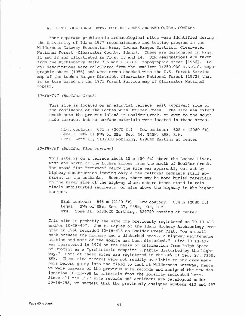
A. SITE LOCATIONAL DATA, BOULDER CREEK ARCHAEOLOGICAL COMPLEX
Four separate prehistoric archaeological sites were identified duringthe University of Idaho 1977 reconnaissance and testing program in theWilderness Gateway Recreation Area, Lochsa Ranger District, ClearwaterNational Forest (Clearwater County, Idaho). These are designated in Figs.11 and 12 and illustrated in Figs. 13 and 14. UTM designations are takenfrom the Huckleberry Butte 7.5 min U.S.G.S. topographic sheet [1966]. Le-gal descriptions were calculated from the Hamilton 1:250,000 U.S.G.S. topo-graphic sheet [1956] and were cross-checked with the U.S. Forest Servicemap of the Lochsa Ranger District, Clearwater National Forest [1972] thatis in turn based on the 1971 Forest Service map of Clearwater NationalForest.
lO-IH-747 (Boulder Creek)
This site is located on an alluvial terrace, east (upriver) side ofthe confluence of the Lochsa with Boulder Creek. The site may extendsouth onto the present island in Boulder Creek, or even to the southside terrace, but no surface materials were located in these areas.
High contour: 631 m (2070 ft) Low contour: 628 m (2060 ft)Legal: NE~ of NW~ of NE~, Sec. 34, T35N, R9E, B.M.UTM: Zone 11, 5132820 Northing, 629840 Easting at center
lO-IH-798 (Boulder Flat Terrace)
This site is on a terrace about 15 m (50 ft) above the Lochsa River,west and north of the Lochsa across from the mouth of Boulder Creek.The broad flat "terrace" below the site was apparently cut out byhighway construction leaving only a few cultural remnants still ap-parent in the cutbanks. However, there may be more buried materialson the river side of the highway where mature trees stand in rela-tively undisturbed sediments, or else above the highway in the higherterrace.
High contour:Legal: SW~ ofUTM: Zone 11,
646 m (2120 ft) Low contour: 634 m (2080 ft)SE~, Sec. 27, T35N, R9E, B.M.5133020 Northing, 629740 Easting at center
This site is probably the same one previously registered as 10-IH-4l3and/or 10-IH-497. Jon P. Dayley of the Idaho Highway Archaeology Pro-gram in 1966 recorded 10-IH-413 on Boulder Creek Flat, "on a smallbank between the highway and a disturbed area ...a highway maintenancestation and most of the source has been disturbed." Site lO-IH-497was registered in 1974 on the basis of information from Ralph Spaceof Orofino as a "prehistoric campsite ...partly disturbed by the high-way." Both of these sites are registered in the SE~ of Sec. 27, T35N,R9E. These site records were not readily available to our crew mem-bers before going into the field to test at Wilderness Gateway, hencewe were unaware of the previous site records and assigned the new des-ignation lO-IH-798 to materials from the locality indicated here.Since all the 1977 site records and artifacts are catalogued underlO-IH-798, we suggest that the previously assigned numbers 413 and 497
41Page 40 is blank
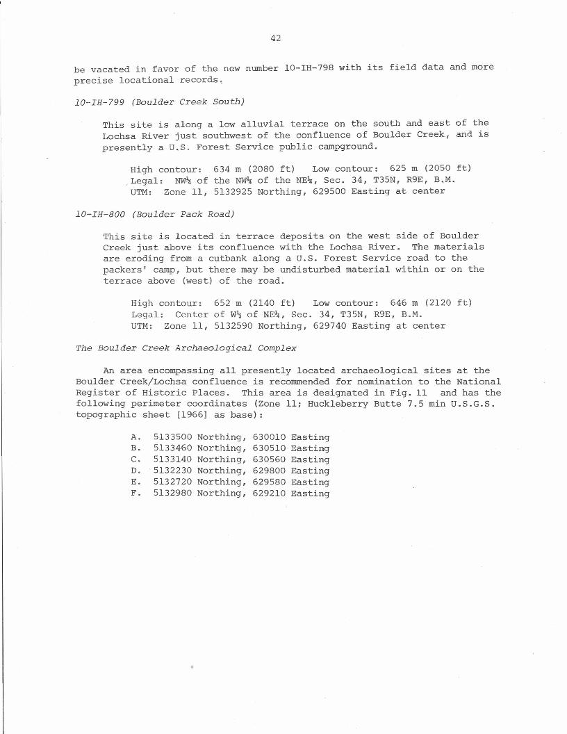
42
be vacated in favor of the new number 10-IH-798 with its field data and moreprecise locational records,
lO-IH-799 (Boulder Creek South)
This site is along a low alluvial terrace on the south and east of theLochsa River just southwest of the confluence of Boulder Creek, and ispresently a U.S. Forest Service public campground.
High contour: 634 m (2080 ft) Low contour: 625 m (2050 ft)Legal: NW~ of the NW~ of the NE~, Sec. 34, T35N, R9E, B.M.UTM: Zone 11, 5132925 Northing, 629500 Easting at center
lO-IH-800 (Boulder Pack Road)
This site is located in terrace deposits on the west side of BoulderCreek just above its confluence with the Lochsa River. The materialsare eroding from a cutbank along a U.S. Forest Service road to thepackers' camp, but there may be undisturbed material within or on theterrace above (west) of the road.
High contour:Legal: CenterUTM: Zone 11,
652 m (2140 ft) Low contour: 646 m (2120of W~ of NE~, Sec. 34, T35N, R9E, B.M.5132590 Northing, 629740 Easting at center
ft)
The Boulder Creek Archaeological Complex
An area encompassing all presently located archaeological sites at theBoulder Creek/Lochs a confluence is recommended for nomination to the NationalRegister of Historic Places. This area is designated in Fig. 11 and has thefollowing perimeter coordinates (Zone 11; Huckleberry Butte 7.5 min U.S.G.S.topographic sheet [1966] as base) :
A. 5133500 Northing, 630010 EastingB. 5133460 Northing, 630510 EastingC. 5133140 Northing, 630560 EastingD. 5132230 Northing, 629800 EastingE. 5132720 Northing, 629580 EastingF. 5132980 Northing, 629210 Easting
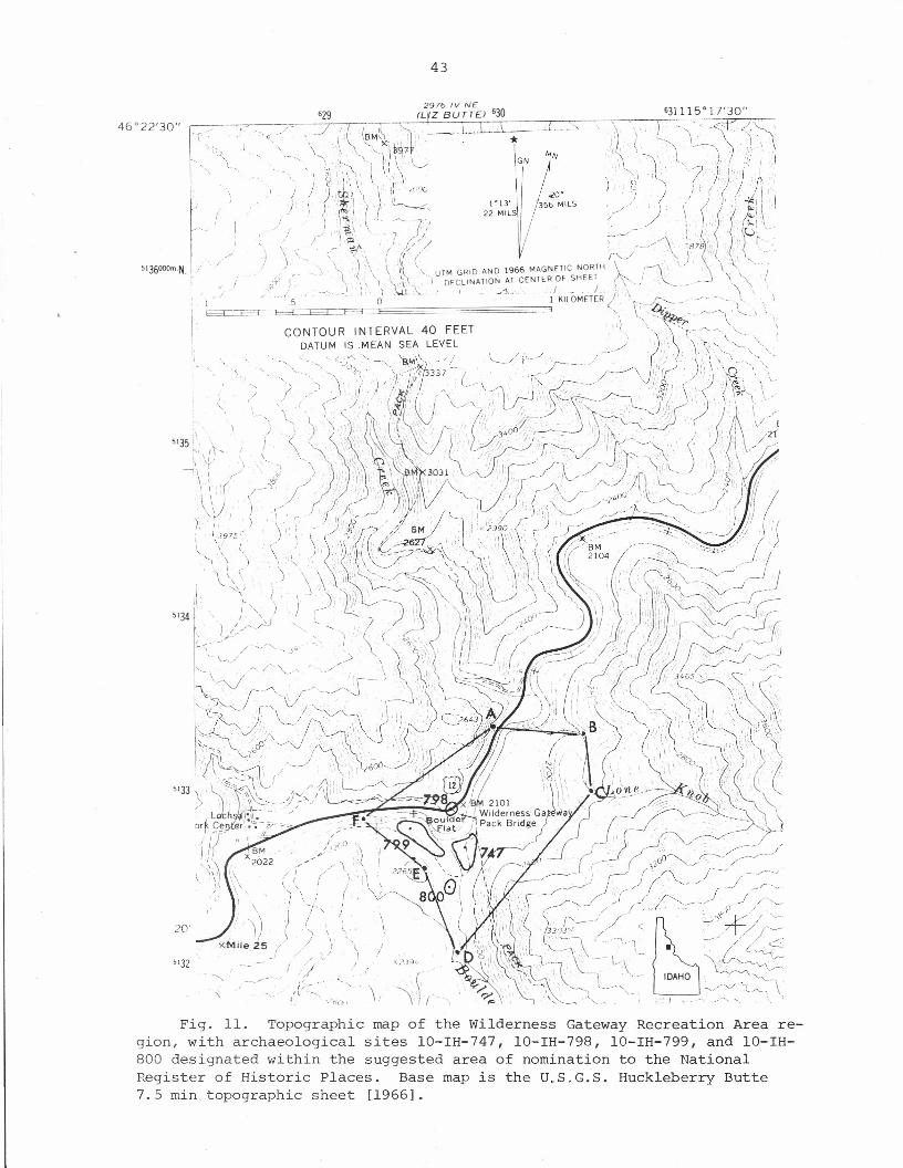
43
I,
5136000mN. I .-'r
20'
5132
Fig. 11. Topographic map of the wilderness Gateway Recreation Area re-gion, with archaeological sites 10-IH-747, 10-IH-798, 10-IH-799, and 10-IH-800 designated within the suggested area of nomination to the NationalRegister of Historic Places. Base map is the U.S.G.S. Huckleberry Butte7.5 min topographic sheet [1966].
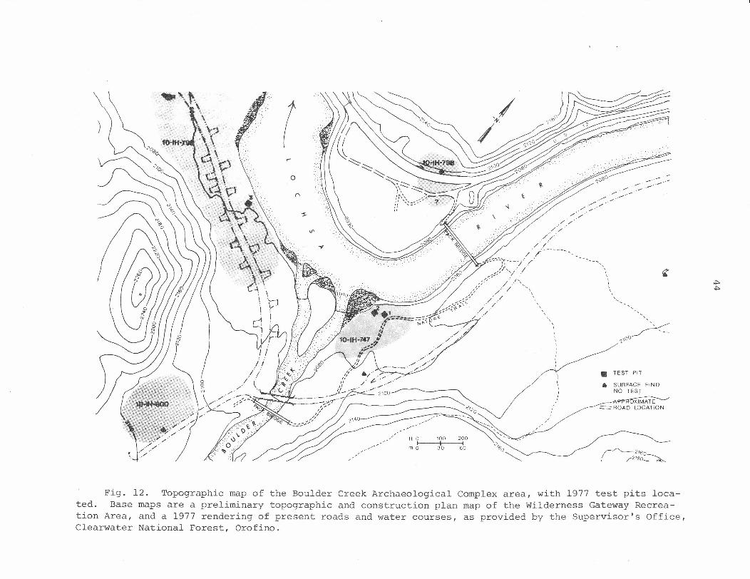
)
•........ ~.•..•• '.-'
../":~',,/ ,,-
./'::.:" ../ /.
////.:
'-,
,,,,,\,
• TEST PIT
• SURFACE FIND.NO TEST
~2160\ /2J80_~
Fig. 12. Topographic map of the Boulder Creek Archaeological Complex area, with 1977 test pits loca-ted. Base maps are a preliminary topographic and construction plan map of the Wilderness Gateway Recrea-tion Area, and a 1977 rendering of present roads and water courses, as provided by the Supervisor's Office,Clearwater National Forest, Orofino.
45
a
b
Fig. 13. Panorama of Boulder Creek confluence with the Lochsa River,the Wilderness Gateway Recreation Area. Photo is taken from the secondterrace of the Lochsa Valley, looking southeast (a) and southwest (b);archaeological sites lO-IH-747, lO-IH-799, and lO-IH-800 are indicated inthe appropriate localities.

46
a
b
Fig. 14. Archaeological sites lO-IH-747, lO-IH-798, and lO-IH--799. a,Test Pit I, lO-IH-747, in foreground (Test Pit 2 behind) looking up the LochsaRiver Valley; note the developed nature trail to the right of the testing area.b, Test Pit 3, lO-IH-799, in foreground looking across the Lochsa River tolO-IH-798 on the upper terrace; note u.s. 12 transecting lO-IH-798.
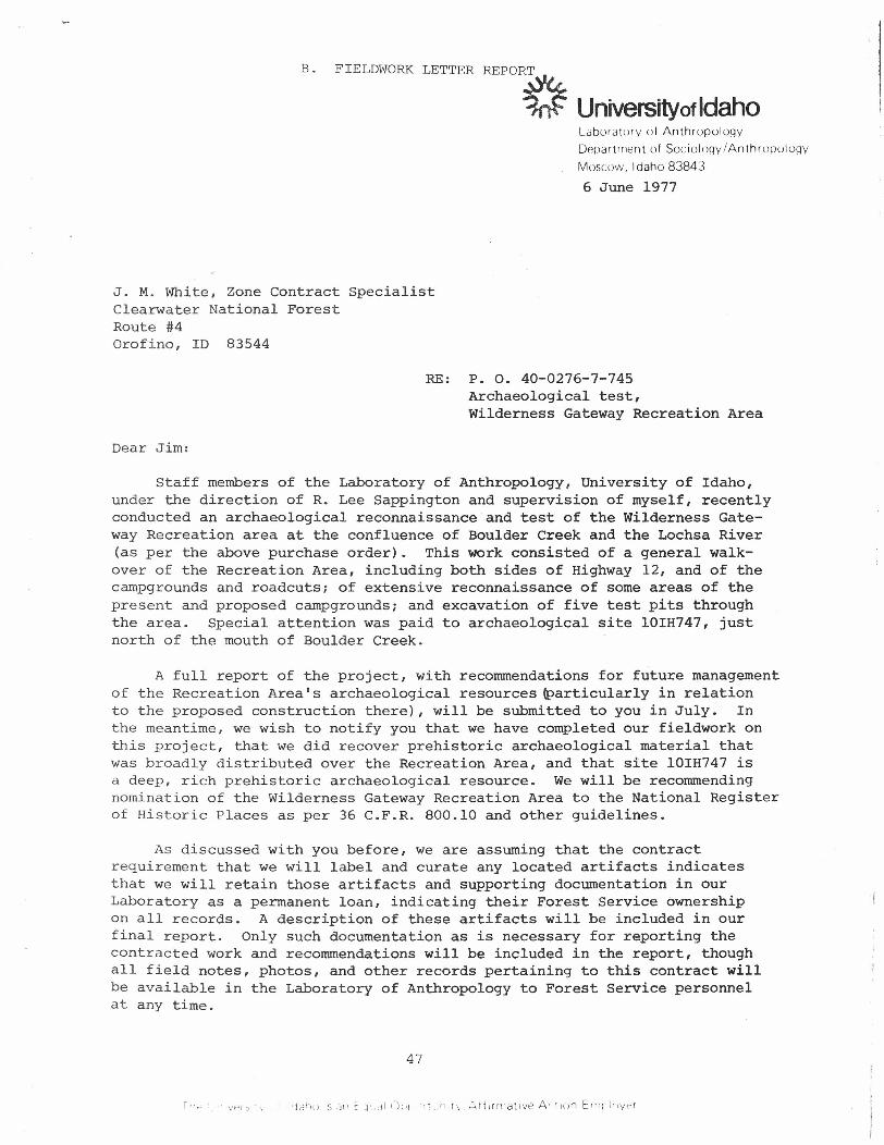
B. FIELDWORKLETTER REPO~
Universityof Idahol.abor atorv of Anthropology
Depar unen t of Sociology/Anthropulogy
Moscow, Idaho 83843
6 June 1977
J. M. White, Zone Contract SpecialistClearwater National ForestRoute #4Orofino, ID 83544
RE: P. O. 40-0276-7-745Archaeological test,Wilderness Gateway Recreation Area
Dear Jim:
Staff members of the Laboratory of Anthropology, University of Idaho,under the direction of R. Lee Sappington and supervision of myself, recentlyconducted an archaeological reconnaissance and test of the Wilderness Gate-way Recreation area at the confluence of Boulder Creek and the Lochsa River(as per the above purchase order). This work consisted of a general walk-over of the Recreation Area, including both sides of Highway 12, and of thecampgrounds and roadcuts; of extensive reconnaissance of some areas of thepresent and proposed campgrounds; and excavation of five test pits throughthe area. Special attention was paid to archaeological site lOIH747, justnorth of the mouth of Boulder Creek.
A full report of the project, with recommendations for future managementof the Recreation Area's archaeological resources ~articularly in relationto the proposed construction there), will be submitted to you in July. Inthe meantime, we wish to notify you that we have completed our fieldwork onthis project, that we did recover prehistoric archaeological material thatwas broadly distributed over the Recreation Area, and that site lOIH747 isa deep, rich prehistoric archaeological resource. We will be recommendingnomination of the wilderness Gateway Recreation Area to the National Registerof Historic Places as per 36 C.F.R. 800.10 and other guidelines.
As discussed with you before, we are assuming that the contractrequirement that we will label and curate any located artifacts indicatesthat we will retain those artifacts and supporting documentation in ourLaboratory as a permanent loan, indicating their Forest Service ownershipon all records. A description of these artifacts will be included in ourfinal report. Only such documentation as is necessary for reporting thecontracted work and recommendations will be included in the report, thoughall field notes, photos, and other records pertaining to this contract willbe available in the Laboratory of Anthropology to Forest Service personnelat any time.
47
48
J. M. WhitePage 26 June 1977
Again, thank you for providing us with the opportunity of evaluatingsome of Idaho's valuable archaeological resources, particularly in anarea as rich as the Wilderness Gateway. The name fumost appropriate, sinceit has probably served as a Gateway for thousands of years and documentationof that fact will enhance the recreational value of the current ForestService facilities. Our final report will be coming to you as soon as wecan manage it, since the nomination of this area to the National Registerwill affect the scheduling of any new construction in that area. Thanksvery much for your personal assistance in g~tting this project set up andimplemented.
Sincerely,
/I
'~\\,-(:" " -.~-Ruthann KnudsonResource Management Archaeologist
cc: John Bledsoe, Forest ServiceTom Hudson, Forest ServiceTom Green, Idaho State Archaeologist
RK:jb
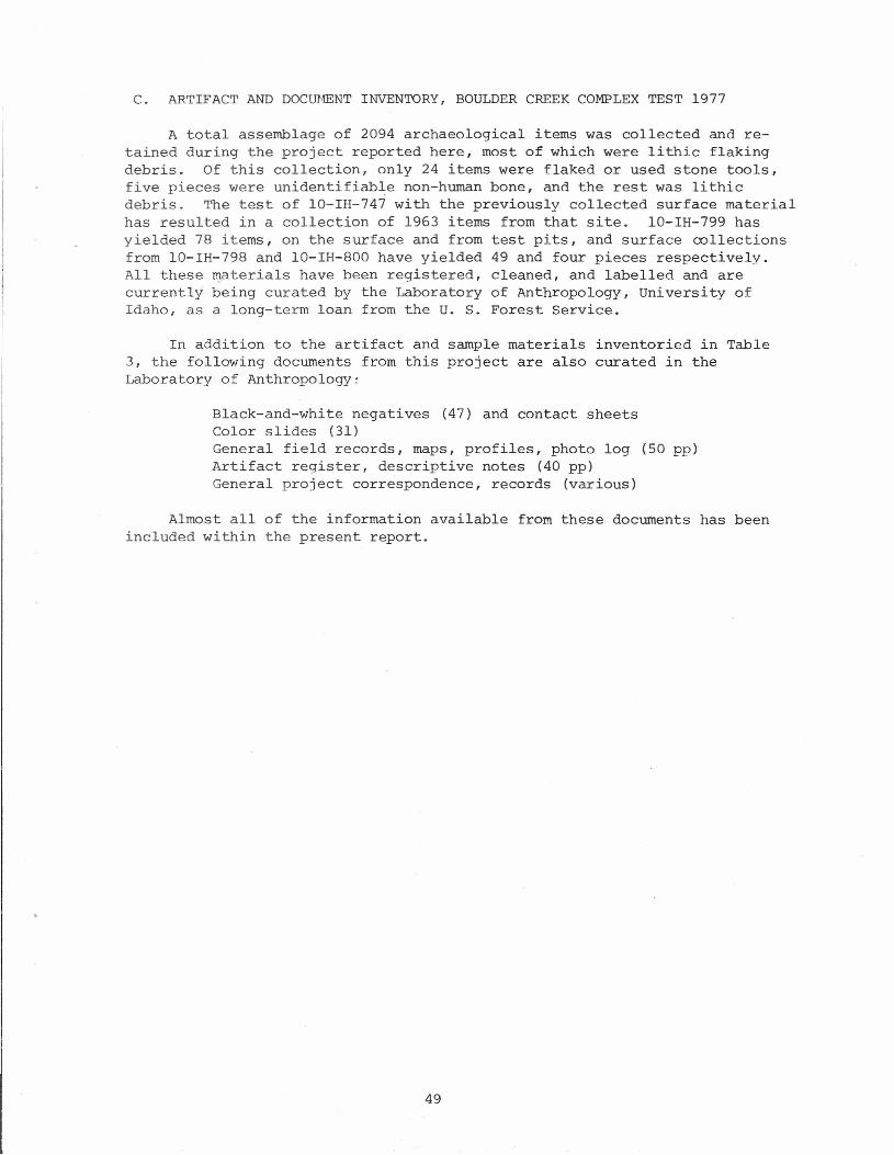
C. ARTIFACT AND DOCUrmNT INVENTORY, BOULDER CREEK COMPLEX TEST 1977
A total assemblage of 2094 archaeological items was collected and re-tained during the project reported here, most of which were lithic flakingdebris. Of this collection, only 24 items were flaked or used stone tools,five pieces were unidentifiable non-human bone, and the rest was lithicdebris. The test of 10-IH-747 with the previously collected surface materialhas resulted in a collection of 1963 items from that site. lO-IH-799 hasyielded 78 items, on the surface and from test pits, and surface collectionsfrom 10-IH-798 and 10-IH-800 have yielded 49 and four pieces respectively.All these ryaterials have been registered, cleaned, and labelled and arecurrently being curated by the Laboratory of Anthropology, University ofIdaho, as a long-term loan from the U. S. Forest Service.
In addition to the artifact and sample materials inventoried in Table3, the following documents from this project are also curated in theLaboratory of Anthropology~
Black-and-white negatives (47) and contact sheetsColor slides (31)General field records, maps, profiles, photo log (50 pp)Artifact register, descriptive notes (40 pp)General project correspondence, records (various)
Almost all of the information available from these documents has beenincluded within the present report.
49
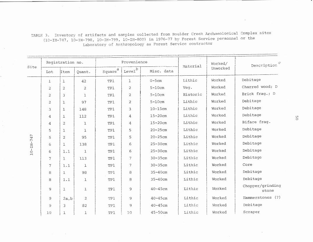
TABLE 3. Inventory of artifacts and samples collected from Boulder Creek Archaeolooical Complex sites(10-IH-747, 10-IH-798, lO-IH-799, 10-IH-800) in 1976-77 by Forest Service personnel or the
Laboratory of Anthropology as Forest Service contractor
Registration no. Provenience I I Worked/Site Material Description
Lot a I b Misc. data Unworkedi Item Quant. Square LevelII 1 1 42 TPI 1 0-5cm Lithic Worked Debitage
I 2 2 2 TPI 2 5-lOcm Veg. Worked Charred wood; D
2 3 1 TPI 2 5-lOcm Historic Worked Brick frag.; D
2 1 97 TPI 2 5-lOcm Lithic Worked Debitage
3 1 148 TPI 3 10-15cm Lithic Worked Debitage
4 1 112 TPI 4 l5-20cm Lithic Worked Debitage
4 2 1 TPI 4 l5-20cm Lithic Worked Biface frag.
5 1 1 TPI 5 20-25cm Lithic Worked Debitager-"'" 5 2 95 TPI 5 20-25cm Lithic Worked Debitager-I:I: 6 1 138 TPI 6 25-30cm Lithic Worked DebitageHI
0 6 1.1 1 TPI 6 25-30cm Lithic Worked Debitage.-l
7 1 113 TPI 7 30-35cm Lithic Worked Debitage
7 1.1 1 TPI 7 30-35cm Lithic Worked Core
8 1 98 TPI 8 35-40cm Lithic Worked Debitage
8 1.1 1 TPI 8 35-40cm Lithic Worked Debitage
9 1 1 TPI 9 40-45cm Lithic vlorked Chopper/grindinstone
9 2a,b 2 TPI 9 40-45cm Lithic Worked Hammerstones (?
9
I3 82 TPI 9 40-45cm Lithic Worked Debitage
10 1 1 TPI 10 45-50cm Lithic Worked ScraperI
c
V1o
g
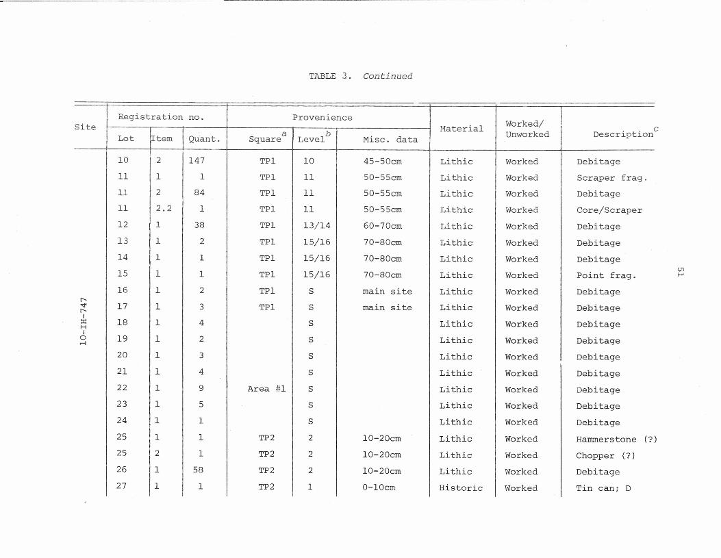
TABLE 3. Continued
I Registration no. ProvenienceSite Material Worked/
lItem a b Misc. data Unworked DescriptionLot Quant. Square Level
I 10 2 147 TPl 10 I 45-50cm Lithic Worked Debitage11 1 1 TPl 11 50-55cm Lithic Worked Scraper frag.11 2 84 TPl 11 50-55cm Lithic Worked Debitage11 2.2 1 TPl 11 50-55cm Lithic Worked Core/Scraper12 1 38 TPl 13/14 60-70cm Lithic Worked Debitage13 1 2 TPl 15/16 70-80cm Lithic Worked Debitage14 1 1 TPl 15/16 70-80cm Lithic Worked Debitage15 1 1 TPl 15/16 70-80cm Lithic Worked Point frag.16 1 2 TPl S main site Lithic Worked Debitage
r-"" 17 1 3 TPl S main site Lithic Worked Debitager-.I::r: 18 1 4 S Lithic Worked DebitageH[.
0 19 1 2 S Lithic Worked Debitage.-!
20 1 3 S Lithic Worked Debitage21 1 4 S Lithic Worked Debitage22 1 9 Area #1 S Lithic Worked Debitage23 1 5 S Lithic Worked Debitage24 1 1 S Lithic Worked Debitage25 1 1 TP2 2 10-20cm Lithic Worked Hammerstone (?25 2 1 TP2 2 10-20cm Lithic Worked Chopper (?)26 1 58 TP2 2 10-20cm Lithic Worked Debitage27 1 1 TP2 1 0-10cm Historic Worked Tin can; D
c
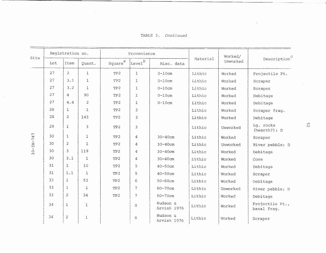
TABLE 3. Continued
Registration no. Provenience Worked/Siteb Material Unworked Descriptiona Misc. dataLot Item Quant. Square Level
27 2 1 TP2 1 0-10em Lithic Worked Projectile Pt.27 3.1 1 TP2 1 0-10cm Lithic Worked Scraper27 3.2 1 TP2 1 0-10cm Lithic Worked Scraper27 4 90 TP2 1 0-10cm Lithic Worked Debitage27 4.4 2 TP2 1 0-10cm Lithic Worked Debitage28 1 1 TP2 3 Lithic Worked Scraper frag.28 2 143 TP2 3 Lithic Worked Debitage
29 1 3 TP2 3 Lithic Unworked Lg. rocks(hearth?) ; D
c-- 30 1 1 TP2 4 30-40cm Lithic Worked<:I' Scraperr-I 30 2 1 TP2 4 30-40cm Lithic Unworked River pebble; D::r:HI 30 3 119 TP2 4 30-40cm Lithic Worked Debitage0~
30 3.1 1 TP2 4 30-40em Lithic Worked Core31 1 10 TP2 5 40-50cm Lithic Worked Debitage31 1.1 1 TP2 5 40-50cm Lithic Worked Scraper32 1 53 TP2 6 50-60cm Lithic Worked Debitage33 1 1 TP2 7 60-70cm Lithic Unworked River pebble; D33 2 34 TP2 7 60-70cm Lithic Worked Debitage
34 1 1 S Hudson & Lithic Worked Projectile Pt.,Arvish 1976 basal frag.
34 2 1 S Hudson & Lithic WorkedArvish 1976 Scraper
c
l.T1N
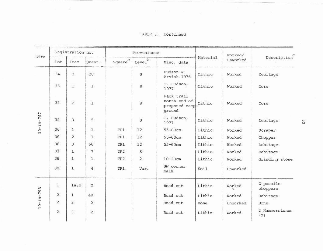
~~~-~- .-----
TABLE 3. Continued
Registration no. Provenience Worked/Site Material Descriptiona b Misc. data UnworkedLot Item Quant. Square Level
34 28 Hudson & Lithic Worked Debitage3 S Arvish 1976
35 1 T. Hudson, Lithic Worked Core1 S 1977Pack trail
35 2 1 S north end of Lithic Worked Coreproposed camp+ground
r-'<:!' T. Hudson,r- 35 3 5 Lithic Worked DebitageI S 1977::r:HI 36 1 1 TPl 12 55-60cm Lithic Worked Scrapera
r-I
36 2 1 TPl 12 55-60cm Lithic Worked Chopper36 3 66 TPl 12 55-60cm Lithic Worked Debitage37 1 7 TP2 S Lithic Worked Debitage38 1 1 TP2 2 10-20cm Lithic Worked Grinding stone
39 1 4 TPl Var. SW corner Soil Unworkedbalk
1 la,b 2 Road cut Lithic Worked 2 possileOJ choppers0'1r-- 2 1 40 Road cut Lithic Worked DebitageI::r:H 2 2 5 Road cut Bone Unworked BoneIar-I
2 Hammerstones2 3 2 Road cut Lithic Worked (?)
c
U1W
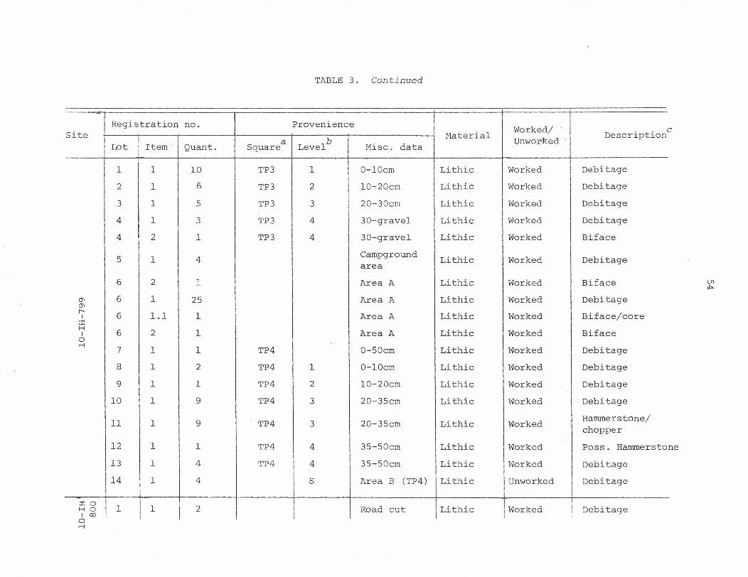
TABLE 3. Continued
Registration no. Provenience Worked/ '.
Siteb
Haterial UnworRed <Descriptiona Misc.Lot Item Quant. Square Level data
1 1 10 TP3 1 O-lOcm Lithic Worked Debitage2 1 6 TP3 2 10-20cm Lithic Worked Debitage3 1 5 TP3 3 20-30cm Lithic Worked Debitage4 1 3 TP3 4 30-gravel Lithic Worked Debitage4 2 1 TP3 4 30-gravel Lithic Worked Biface
5 1 4 Campground Lithic Worked Debitagearea6 2 1 Area A Lithic Horked Biface
(jI 6 1 25 Area A Lithic Worked Debitage(jI
r-6 1.1 1 Area A Lithic Worked Biface/coreI
::r::H
6 2 1 Area A Lithic Worked BifaceI0r-I
7 1 1 TP4 0-50cm Lithic Worked Debitage8 1 2 TP4 1 O-lOcm Lithic Ivorked Debitage9 1 1 TP4 2 10-20cm Lithic Worked Debitage
10 1 9 TP4 3 20-35cm Lithic Worked Debitage
11 1 9 TP4 3 20-35cm Lithic Worked Hammerstone/chopper
12 1 1 TP4 4 35-50cm Lithic Worked Poss. Hammers to13 1 4 TP4 4 35-50cm Lithic Worked Debitage14 1 4 S Area B (TP4) Lithic Unworked Debitage
-::r::o 1 1 2 Road cut Lithic Worked Debitage.H 0
I.I 00;
c
ne
ar-I
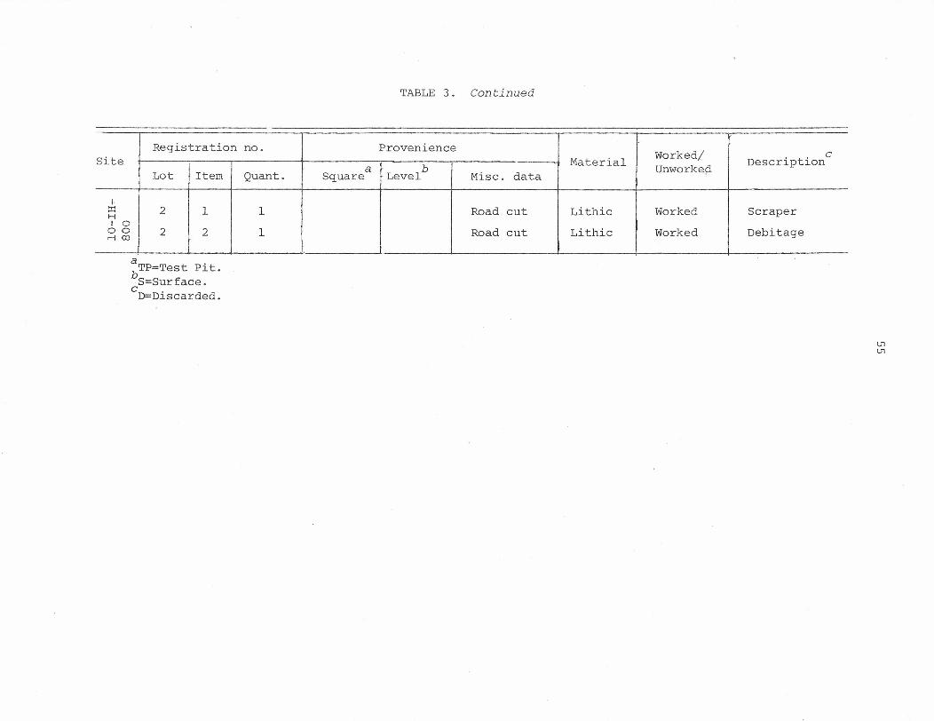
TABLE 3. Continued
Registration no. Provenience Worked/ CSite~Item b
Material Unworke¢i DescriptionaLot Quant. Square Level Misc. data
I:r: 2 1 1 Road cut Lithic Worked ScraperHI 0
0 0 2 2 1 Road cut Lithic Worked Debitage.--f co
a .bTP=Test Plt.S=Surface.
cO=Discarded.
U1U1


