Embed Size (px)
Citation preview
Upper ocean heat content in the Nordic seas
Daniela Di Iorio1 and Caitlin Sloan1
Received 4 December 2007; revised 12 January 2009; accepted 26 February 2009; published 25 April 2009.
[1] Seven years of temperature profiles are obtained from the Argo float project and areused to study the vertically integrated heat content for the Nordic seas which is broken upinto the Norwegian Basin, Greenland Sea, Lofoten region, and Iceland Plateau. The WorldOcean Atlas 2005 (WOA05) is used as the climatological baseline for temperature andhence heat content. Temporally and spatially averaged temperature profiles within theNorwegian and Iceland basins show good agreement between the Argo and WOA05 datasets. For the Greenland and Lofoten basins, the WOA05 data show cooler surfacetemperatures (by 1–2�C) but still lie within 1 standard deviation of each other over the7-year period. The Argo float data show circulation within each of the basins that iscounterclockwise, and some of the floats eventually disperse toward the outer edges of thebasins. Vertically integrated heat content from 0 to 1200 m shows similar characteristics asthe WOA05 results including the timing and strength of the seasonal variability. Theanomalous heat content for the Greenland and Norwegian sea basins is calculated in depthbins of 400 m. The Greenland Sea shows a warming trend over the 7 years of study, whichcorresponds to a temperature increase of (4.1 ± 0.3) � 10�2 �C/yr. The Norwegian Seabasin shows interannual variability in heat content for the surface layer (0–400 m) thatmay be related to the North Atlantic Oscillation (NAO). During an NAO+ phase, theNorwegian Basin shows a warm phase, and during an NAO� phase, the Norwegian Basinis in a cold phase; the correlation is small (r = 0.32) but different from zero correlationonly at the 90% level, implying that the variability in the AHC may be due to (1) localatmospheric forcing and hence changes in heat loss, (2) atmospheric pressure differencesthat are not resolved by the NAO index, and (3) exchange of heat with the basinboundaries.
Citation: Di Iorio, D., and C. Sloan (2009), Upper ocean heat content in the Nordic seas, J. Geophys. Res., 114, C04017,
doi:10.1029/2007JC004674.
1. Introduction
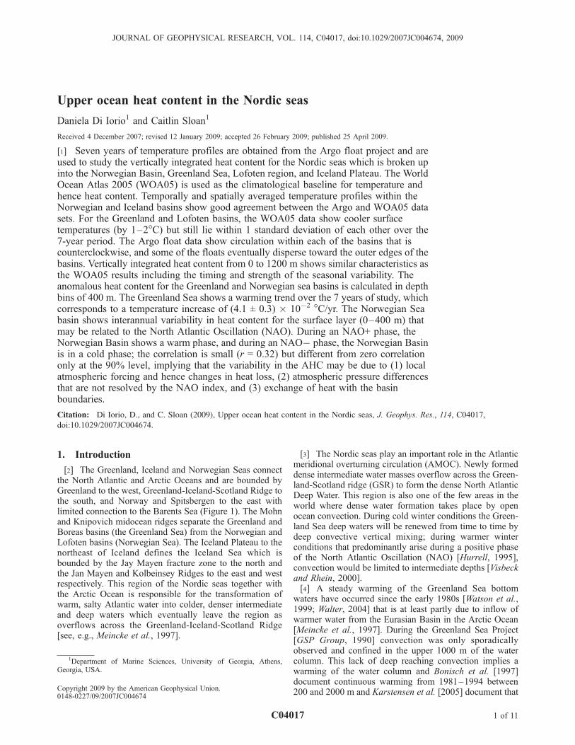
[2] The Greenland, Iceland and Norwegian Seas connectthe North Atlantic and Arctic Oceans and are bounded byGreenland to the west, Greenland-Iceland-Scotland Ridge tothe south, and Norway and Spitsbergen to the east withlimited connection to the Barents Sea (Figure 1). The Mohnand Knipovich midocean ridges separate the Greenland andBoreas basins (the Greenland Sea) from the Norwegian andLofoten basins (Norwegian Sea). The Iceland Plateau to thenortheast of Iceland defines the Iceland Sea which isbounded by the Jay Mayen fracture zone to the north andthe Jan Mayen and Kolbeinsey Ridges to the east and westrespectively. This region of the Nordic seas together withthe Arctic Ocean is responsible for the transformation ofwarm, salty Atlantic water into colder, denser intermediateand deep waters which eventually leave the region asoverflows across the Greenland-Iceland-Scotland Ridge[see, e.g., Meincke et al., 1997].
[3] The Nordic seas play an important role in the Atlanticmeridional overturning circulation (AMOC). Newly formeddense intermediate water masses overflow across the Green-land-Scotland ridge (GSR) to form the dense North AtlanticDeep Water. This region is also one of the few areas in theworld where dense water formation takes place by openocean convection. During cold winter conditions the Green-land Sea deep waters will be renewed from time to time bydeep convective vertical mixing; during warmer winterconditions that predominantly arise during a positive phaseof the North Atlantic Oscillation (NAO) [Hurrell, 1995],convection would be limited to intermediate depths [Visbeckand Rhein, 2000].[4] A steady warming of the Greenland Sea bottom
waters have occurred since the early 1980s [Watson et al.,1999; Walter, 2004] that is at least partly due to inflow ofwarmer water from the Eurasian Basin in the Arctic Ocean[Meincke et al., 1997]. During the Greenland Sea Project[GSP Group, 1990] convection was only sporadicallyobserved and confined in the upper 1000 m of the watercolumn. This lack of deep reaching convection implies awarming of the water column and Bonisch et al. [1997]document continuous warming from 1981–1994 between200 and 2000 m and Karstensen et al. [2005] document that
JOURNAL OF GEOPHYSICAL RESEARCH, VOL. 114, C04017, doi:10.1029/2007JC004674, 2009
1Department of Marine Sciences, University of Georgia, Athens,Georgia, USA.
Copyright 2009 by the American Geophysical Union.0148-0227/09/2007JC004674
C04017 1 of 11
the Greenland Sea Intermediate Water changed to warmerand fresher mode during the 1990s. According to Alekseevet al. [2001] averaged temperature profiles in the centralGreenland Sea for the 1980s showed a significant subsur-face (200–400 m) warming and then a rapid warming of thewater column below 500 m during the 1990s. This increasein heat content in the upper layers was explained either byreduction of the heat loss to the atmosphere or the increasedvolume and temperature of the AW inflow from the NorthAtlantic.[5] According to Isachsen et al. [2007], the bulk of the
intermediate and deep waters in the Nordic seas are formedalong the advective path of the Norwegian Atlantic Current(NwAC) and hence in the Norwegian Sea (Norwegian andLofoten basins). The warming of the Norwegian Sea alongthe major pathways of the Atlantic Inflow ranging from theeastern subpolar gyre to Fram Strait has been documentedby Furevik [2001] for measurements in the 1980s and 1990sand more recently by Holliday et al. [2008] for measure-ments spanning a 30-year period (1978–2006). The Atlan-tic inflow encompasses the NwAC of which the westernbranch, originates as a major pathway over the Iceland-Faroe Ridge, continues eastward into the Norwegian Sea,then turns to the northwest toward the Mohn Ridge alongthe Voring Plateau and then either recirculates back into theNorwegian Basin or follows ridges (as a polar front jet)toward Spitsbergen and Fram Strait where it can recirculateback into the Greenland Sea [Orvik and Niiler, 2002;Jakobsen et al., 2003;Mauritzen, 1996a; Nost and Isachsen,2003]. The eastern branch originates through the Faroe-Shetland Channel which then follows the Norwegian coast
and then splits with some flow turning into the Barents Seaand the rest becoming the West Spitsbergen Current (WSC)that flows into the Arctic which after modification cancirculate back to the Nordic seas eventually forming upperNorwegian Sea Deep Water.[6] Thus our objective is to quantify the anomalous upper
ocean heat content for the Greenland and Norwegian Sea forthe past 7 years using the Argo float data to quantifywhether warming is continuing in the upper ocean watermasses which are an important component of the AMOCand compare to atmospheric conditions via the NorthAtlantic Oscillation index. Section 2 describes the Argodata and the World Ocean Atlas 2005 (WOA05) climatol-ogy with section 3 showing significant results in terms ofcirculation, vertically integrated heat and anomalous heatcontent. Section 4 summarizes the results and discusses theNorwegian Basin results to the North Atlantic Oscillation.
2. Methods
[7] The Argo float data obtained from the CoriolisOperational Oceanography web site (www.coriolis.eu.org)are used for our potential temperature profiles. We used datacollected within the latitude band of 60�N and 80�N andlongitude band of 24�W and 18�E, outlining the part of theNordic seas which consists of the Greenland, Norwegianand Iceland Seas (see Figure 1). Each major basin isoutlined with yellow polygons which generally follow theridge system and the 500 m continental slope contour. TheGreenland Sea, in our analysis, contains the Greenlandbasin, most of the Boreas basin and the West Iceland Basin,
Figure 1. Bathymetry of the Nordic seas using TerrainBase, with major sea basins and ridge systemsidentified. Yellow lines outline the Greenland Sea, Norwegian Basin, Lofoten region, and Iceland Plateauareas.
C04017 DI IORIO AND SLOAN: OCEAN HEAT CONTENT IN THE NORDIC SEAS
2 of 11
C04017
and is identified with a polygon following the KolbeinseyRidge, Jan Mayen Fracture Zone, Mohn Ridge and Knipo-vich Ridge systems along the eastern side and the Green-land continental slope along the west. The Norwegian Sea isbroken up into the Norwegian and Lofoten basins which arepartly separated by the Voring Plateau. The NorwegianBasin is outlined with Mohn Ridge to the north, the JanMayen Ridge to the west, the Iceland-Scotland Ridge to thesouthwest, and the continental slope boundary toward theeast. The Lofoten region consists of the Lofoten basin andthe west Spitsbergen region bounded by the ridge systemsto the west and the continental slope to the east. Finally theIceland Plateau region which identifies the Central IcelandSea, is separated by the Norwegian Basin by the Jan MayenRidge, separated from the West Iceland Basin by theKolbeinsey Ridge and bounded by Iceland continental slopeto the south.[8] Data were collected from 23 April 2001 to 30 April
2008 with the number of Argo floats increasing with time inthis area to a total of 49 different unique float identificationsover the 7-year period. The profiles that were classified as‘‘good data only’’ which had the quality control (QC) flagof 1 provided by the organization were used in our analysis.This QC value means that all real time QC tests, which aredocumented in the Argo manual by Wong et al. [2008],were passed. Some of these controls include a pressureincreasing test, detection of spikes, gradient steepnesschecks and a gross temperature sensor drift test. It shouldbe noted that none of the profiles used here were fromSOLO floats with FSI CTD (Argo Program WHOI) whichhave a recently discovered pressure offset [Willis et al.,2007].[9] Missing values in the temperature profiles were
replaced with a linearly interpolated value only if the depthseparation between the nearest values was less than 100 m.The number of profiles in each of the basins that containedgood data between the depth intervals of 0–400, 400–800,800–1200 and 0–1200 m are summarized in Table 1together with the percentage of profiles used, shown inparenthesis. The number of profiles vary depending onwhether missing values could be corrected within eachdepth interval. The depth interval 400–800 m had thegreatest number of good profiles (at most 2% discarded intotal) as most of the uncorrected missing values were eitherat the surface (at most 5.4% discarded as will be explained)or the profile did not extend to 1200 m (a maximum of 8%discarded).[10] Each profile of potential temperature was then line-
arly interpolated onto a grid having a constant depthincrement of 10 m for easy vertical integration. Thoseprofiles that do not extend to within 10 m of the surface
were also eliminated for the 0–400 m and 0–1200 manalysis. This is because there is a sharp and shallowsummer thermocline in the Greenland and Iceland Seas aswill be shown. Values of temperature for the surface (0 m)were given the same values as those at depths within 10 m;all the profiles used for the 0–400 and 0–1200 m intervalstypically had measurements at 4–8 m from the surface.[11] The temperature profiles were sorted by time and
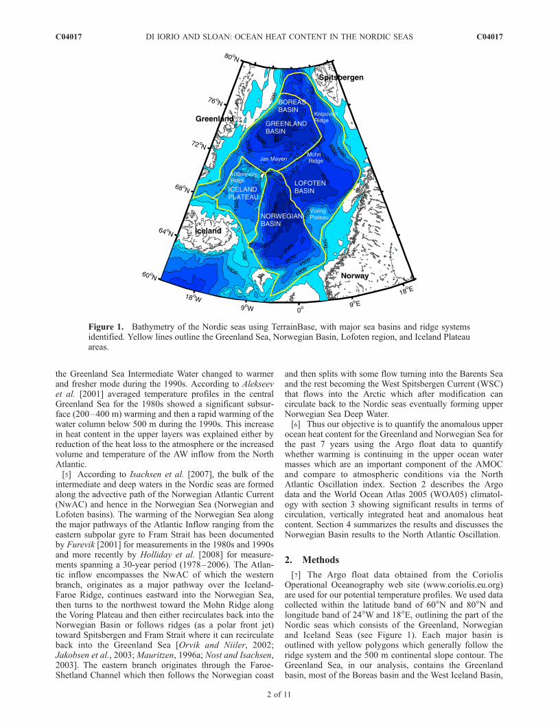
basin using the polygons in Figure 1, and their locations areshown in Figure 2. These locations correspond to the Argo’sposition, after profiling the water column, during whichtime they were on the surface for 6–12 hours for commu-nication and data transfer purposes. Each subplot represents�455 days which corresponds to 1 year and 2 months (away to fit 7 years of data evenly over 6 subplots).[12] The profiles were then averaged over the summer
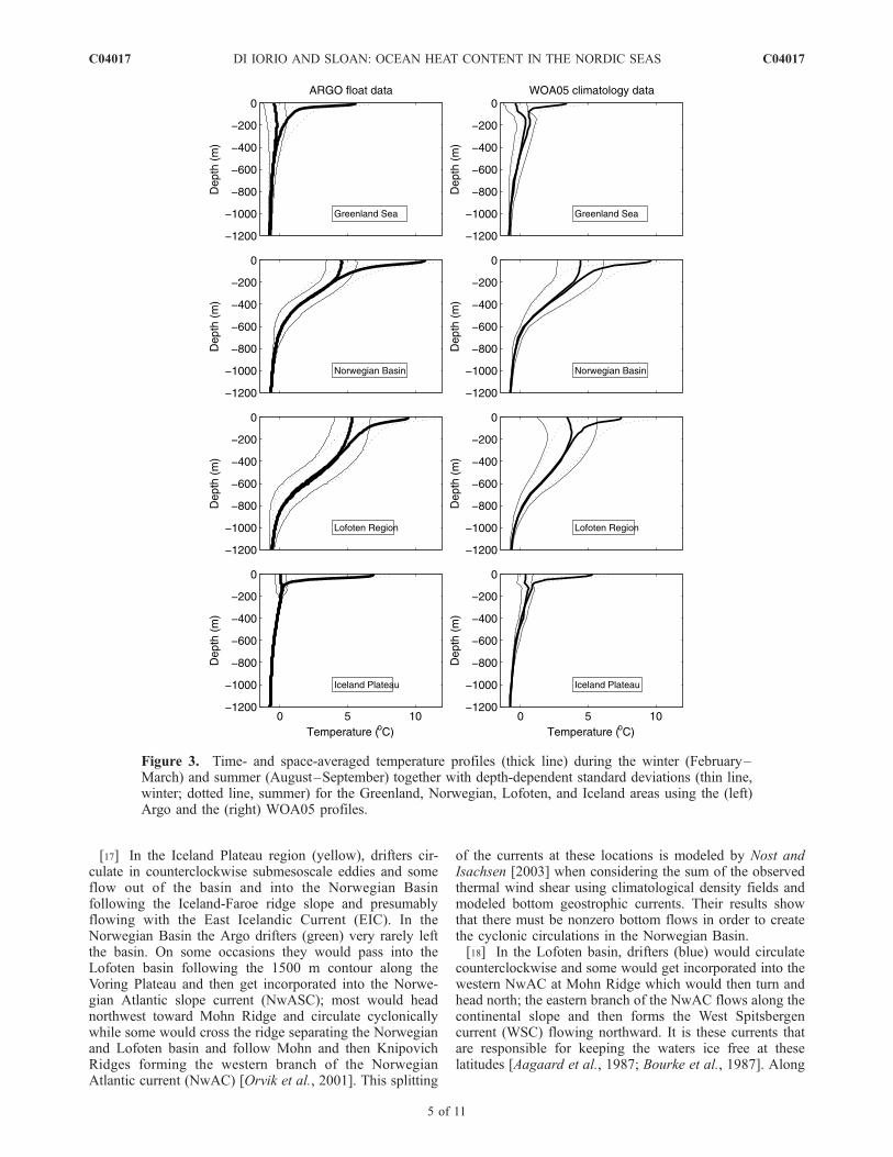
(August/September) and winter (February/March) monthsfor the 7 years of data and averaged over space (within eachpolygon). The mean temperature profiles along with theirdepth-dependent standard deviations are shown in Figure 3.Temperature characteristics in the Norwegian and Lofotenbasins show warm Atlantic water, which flows in primarilyacross the Iceland-Scotland Ridge, and forms the westernand eastern branch of the Norwegian Atlantic current(NwAC). The thickness of this water is 500–600 m in theNorwegian Basin consistent with the results of Mauritzen[1996a]. As the Atlantic Water enters the Lofoten basin, itfills a larger portion of the water column extending down to800 m depth [Nilsen and Falck, 2006; Mauritzen, 1996a].According to Orvik [2004] this deepening of Atlantic Waterin the Lofoten basin is due to a reduced speed in the polarfront jet (western branch of the NwAC along the easternMohn Ridge) due to its encounter with a deep countercurrent associated with the Lofoten basin cyclonic gyre.Because of conservation of volume the reduced speed willcause a deepening of the AW. The seasonal difference insurface temperature for the Norwegian and Lofoten basins isapproximately 6�C and 4�C respectively.[13] In the Greenland and Iceland Seas the summer
surface waters are warm and a very shallow thermoclineis apparent compared to winter time when there is littlestratification. This highly variable upper layer is modifiedthrough atmospheric exchange and lateral intrusions fromthe basin perimeter: the East Greenland current along thecontinental slope carries a mixture of Atlantic Water (AW)recirculated in Fram Strait, AW recirculated in the ArcticOcean, and Polar waters [Mauritzen, 1996a]. From theaveraged time series this upper layer is �100 m deep inthe Iceland Sea and �300 m in the Greenland Sea. Belowthe Greenland Sea upper layer is the Greenland See Inter-mediate Water which is a relatively homogenous patch of
Table 1. Final Number of Argo Profiles Used in the Nordic Regions That Were Within the Depth Bins Showna
Region 0–400 m 400–800 m 800–1200 m 0–1200 m Total
Greenland Sea 975 (96.8) 1006 (99.9) 1005 (99.8) 973 (96.6) 1007Norwegian Basin 1218 (94.6) 1270 (98.6) 1185 (92) 1135 (88.1) 1288Lofoten Region 1105 (97.3) 1117 (98.3) 1058 (93.1) 1041 (91.6) 1136Iceland Plateau 229 (99.1) 231 (100) 228 (98.7) 226 (97.8) 231Total 3527 (96.3) 3624 (99.0) 3476 (94.9) 3375 (92.2) 3662
aThe total number of profiles for each region is the last column. The numbers in parenthesis represent the percentage of profiles used.
C04017 DI IORIO AND SLOAN: OCEAN HEAT CONTENT IN THE NORDIC SEAS
3 of 11
C04017
cold water affected by winter convection [Karstensen et al.,2005]. In the early 1990s this layer consisted of a temper-ature maximum at about 700 m in 1992 and then subse-quently deepened to 1500 m in 2000. Over the course of this7-year data set no temperature maximum was observed inthe individual profiles extending from 700 to 1200 m.[14] The World Ocean Atlas 2005 (WOA05) [Locarnini
et al., 2006] was used for the monthly climatological fieldsof temperature at standardized depths on a 1� grid within theNordic seas. Spatial (within each polygon) and temporal(during the summer and winter months) averages of tem-perature, together with the calculated depth-dependent stan-dard deviations are also shown in Figure 3 for comparisonto the Argo float profiles. One significant difference intemperature that is observed in the 0–200 m depth of theGreenland Sea (and is also apparent for the Iceland Plateauregion) is that the WOA05 shows cooler mean temperaturesduring summer. During winter a shallow temperature max-imum layer is more pronounced with the WOA05 data.Another difference is in the Lofoten region with a 2 degreedifference in the surface layer. Despite these differences themean Argo temperature profiles still remain within 1standard deviation of the WOA05 climatology.[15] Finally, the Argo data were then sorted in terms of
their platform identification so that each drifter could betracked in time and thus give a representative circulation
pattern for each basin. The Argo floats are designed to driftfor approximately 9 days at its cruising depth (typically1000 m) and then fall to a depth of 2000 m to start its profileto the surface, sampling pressure, temperature and conduc-tivity. Data including its location is transmitted via satelliteover a period of 6 to 12 hours while at the surface and then thefloat sinks to its cruising depth to start the cycle over again.
3. Results
3.1. Circulation
[16] Representative drifter tracks, which is a subset of allthe drifter data used, for each of the basins are shown inFigure 4; a strong dependence on topographic steering isevident. The general circulation results here are very muchin agreement with the surface circulation outlined byPoulain et al. [1996] and more recently by Jakobsen etal. [2003] for their Lagrangian studies. Each of the basinshave counterclockwise circulation cells (cyclonic gyres) andthe Argo drifter paths show limited connections between thebasins possibly because the drifters tend to follow bathymet-ric contours when submerged at depth. As the drifters are onthe surface for 6–12 hours and at depth for�9 days we do notseparate surface from deep ocean trajectories, which can bedone following the methods of Park et al. [2005].
Figure 2. Argo float locations processed for the Greenland Sea (red), Iceland Plateau (yellow),Norwegian Basin (green), and the Lofoten region (blue) for the 7 years of data. The locations correspondto the Argo’s position, after profiling the water column, during which time they were on the surface for6–12 hours for communication and data transfer purposes. Note that each subplot spans 1 year 2 months.
C04017 DI IORIO AND SLOAN: OCEAN HEAT CONTENT IN THE NORDIC SEAS
4 of 11
C04017
[17] In the Iceland Plateau region (yellow), drifters cir-culate in counterclockwise submesoscale eddies and someflow out of the basin and into the Norwegian Basinfollowing the Iceland-Faroe ridge slope and presumablyflowing with the East Icelandic Current (EIC). In theNorwegian Basin the Argo drifters (green) very rarely leftthe basin. On some occasions they would pass into theLofoten basin following the 1500 m contour along theVoring Plateau and then get incorporated into the Norwe-gian Atlantic slope current (NwASC); most would headnorthwest toward Mohn Ridge and circulate cyclonicallywhile some would cross the ridge separating the Norwegianand Lofoten basin and follow Mohn and then KnipovichRidges forming the western branch of the NorwegianAtlantic current (NwAC) [Orvik et al., 2001]. This splitting
of the currents at these locations is modeled by Nost andIsachsen [2003] when considering the sum of the observedthermal wind shear using climatological density fields andmodeled bottom geostrophic currents. Their results showthat there must be nonzero bottom flows in order to createthe cyclonic circulations in the Norwegian Basin.[18] In the Lofoten basin, drifters (blue) would circulate
counterclockwise and some would get incorporated into thewestern NwAC at Mohn Ridge which would then turn andhead north; the eastern branch of the NwAC flows along thecontinental slope and then forms the West Spitsbergencurrent (WSC) flowing northward. It is these currents thatare responsible for keeping the waters ice free at theselatitudes [Aagaard et al., 1987; Bourke et al., 1987]. Along
Figure 3. Time- and space-averaged temperature profiles (thick line) during the winter (February–March) and summer (August–September) together with depth-dependent standard deviations (thin line,winter; dotted line, summer) for the Greenland, Norwegian, Lofoten, and Iceland areas using the (left)Argo and the (right) WOA05 profiles.
C04017 DI IORIO AND SLOAN: OCEAN HEAT CONTENT IN THE NORDIC SEAS
5 of 11
C04017
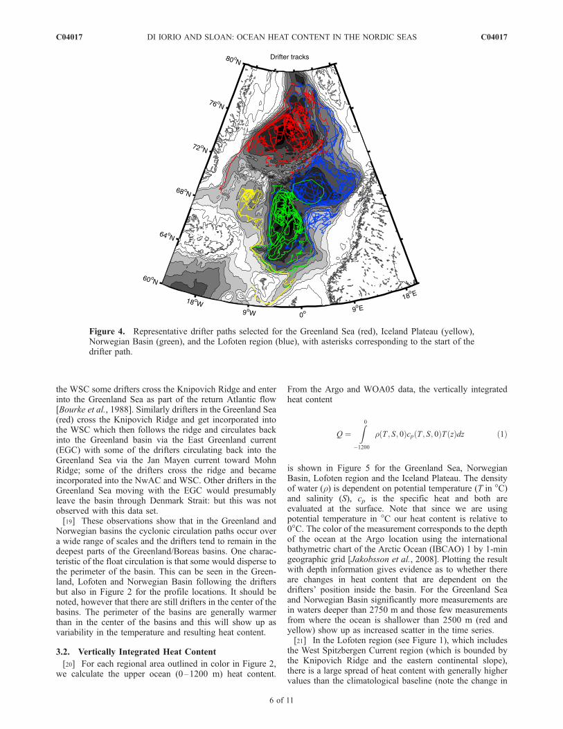
the WSC some drifters cross the Knipovich Ridge and enterinto the Greenland Sea as part of the return Atlantic flow[Bourke et al., 1988]. Similarly drifters in the Greenland Sea(red) cross the Knipovich Ridge and get incorporated intothe WSC which then follows the ridge and circulates backinto the Greenland basin via the East Greenland current(EGC) with some of the drifters circulating back into theGreenland Sea via the Jan Mayen current toward MohnRidge; some of the drifters cross the ridge and becameincorporated into the NwAC and WSC. Other drifters in theGreenland Sea moving with the EGC would presumablyleave the basin through Denmark Strait: but this was notobserved with this data set.[19] These observations show that in the Greenland and
Norwegian basins the cyclonic circulation paths occur overa wide range of scales and the drifters tend to remain in thedeepest parts of the Greenland/Boreas basins. One charac-teristic of the float circulation is that some would disperse tothe perimeter of the basin. This can be seen in the Green-land, Lofoten and Norwegian Basin following the driftersbut also in Figure 2 for the profile locations. It should benoted, however that there are still drifters in the center of thebasins. The perimeter of the basins are generally warmerthan in the center of the basins and this will show up asvariability in the temperature and resulting heat content.
3.2. Vertically Integrated Heat Content
[20] For each regional area outlined in color in Figure 2,we calculate the upper ocean (0–1200 m) heat content.
From the Argo and WOA05 data, the vertically integratedheat content
Q ¼Z0
�1200
r T ; S; 0ð Þcp T ; S; 0ð ÞT zð Þdz ð1Þ
is shown in Figure 5 for the Greenland Sea, NorwegianBasin, Lofoten region and the Iceland Plateau. The densityof water (r) is dependent on potential temperature (T in �C)and salinity (S), cp is the specific heat and both areevaluated at the surface. Note that since we are usingpotential temperature in �C our heat content is relative to0�C. The color of the measurement corresponds to the depthof the ocean at the Argo location using the internationalbathymetric chart of the Arctic Ocean (IBCAO) 1 by 1-mingeographic grid [Jakobsson et al., 2008]. Plotting the resultwith depth information gives evidence as to whether thereare changes in heat content that are dependent on thedrifters’ position inside the basin. For the Greenland Seaand Norwegian Basin significantly more measurements arein waters deeper than 2750 m and those few measurementsfrom where the ocean is shallower than 2500 m (red andyellow) show up as increased scatter in the time series.[21] In the Lofoten region (see Figure 1), which includes
the West Spitzbergen Current region (which is bounded bythe Knipovich Ridge and the eastern continental slope),there is a large spread of heat content with generally highervalues than the climatological baseline (note the change in
Figure 4. Representative drifter paths selected for the Greenland Sea (red), Iceland Plateau (yellow),Norwegian Basin (green), and the Lofoten region (blue), with asterisks corresponding to the start of thedrifter path.
C04017 DI IORIO AND SLOAN: OCEAN HEAT CONTENT IN THE NORDIC SEAS
6 of 11
C04017
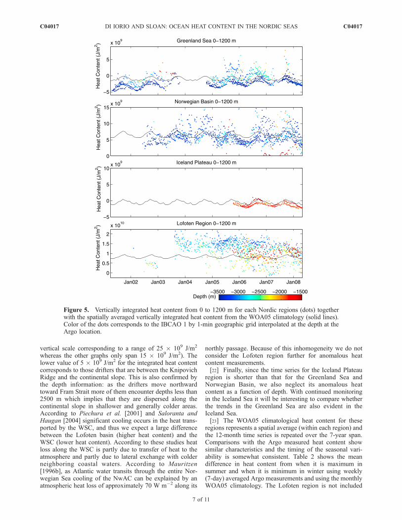
vertical scale corresponding to a range of 25 � 109 J/m2
whereas the other graphs only span 15 � 109 J/m2). Thelower value of 5 � 109 J/m2 for the integrated heat contentcorresponds to those drifters that are between the KnipovichRidge and the continental slope. This is also confirmed bythe depth information: as the drifters move northwardtoward Fram Strait more of them encounter depths less than2500 m which implies that they are dispersed along thecontinental slope in shallower and generally colder areas.According to Piechura et al. [2001] and Saloranta andHaugan [2004] significant cooling occurs in the heat trans-ported by the WSC, and thus we expect a large differencebetween the Lofoten basin (higher heat content) and theWSC (lower heat content). According to these studies heatloss along the WSC is partly due to transfer of heat to theatmosphere and partly due to lateral exchange with colderneighboring coastal waters. According to Mauritzen[1996b], as Atlantic water transits through the entire Nor-wegian Sea cooling of the NwAC can be explained by anatmospheric heat loss of approximately 70 W m�2 along its
northly passage. Because of this inhomogeneity we do notconsider the Lofoten region further for anomalous heatcontent measurements.[22] Finally, since the time series for the Iceland Plateau
region is shorter than that for the Greenland Sea andNorwegian Basin, we also neglect its anomalous heatcontent as a function of depth. With continued monitoringin the Iceland Sea it will be interesting to compare whetherthe trends in the Greenland Sea are also evident in theIceland Sea.[23] The WOA05 climatological heat content for these
regions represents a spatial average (within each region) andthe 12-month time series is repeated over the 7-year span.Comparisons with the Argo measured heat content showsimilar characteristics and the timing of the seasonal vari-ability is somewhat consistent. Table 2 shows the meandifference in heat content from when it is maximum insummer and when it is minimum in winter using weekly(7-day) averaged Argo measurements and using the monthlyWOA05 climatology. The Lofoten region is not included
Figure 5. Vertically integrated heat content from 0 to 1200 m for each Nordic regions (dots) togetherwith the spatially averaged vertically integrated heat content from the WOA05 climatology (solid lines).Color of the dots corresponds to the IBCAO 1 by 1-min geographic grid interpolated at the depth at theArgo location.
C04017 DI IORIO AND SLOAN: OCEAN HEAT CONTENT IN THE NORDIC SEAS
7 of 11
C04017
because of the large variability in the Argo measurement.The Greenland Sea area has the smallest seasonal change inheat content, the Iceland Plateau region has the next largestdifference and then the Norwegian Basin has the greatestseasonal change in heat content (even compared to theclimatological baseline) possibly because of interannualvariations that would cause a warmer summer and/or colderwinter (as will be discussed).
3.3. Anomalous Heat Content
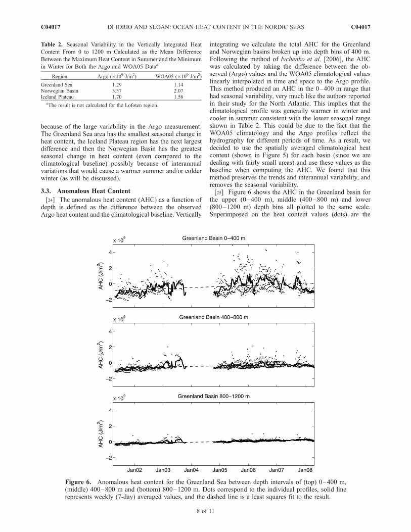
[24] The anomalous heat content (AHC) as a function ofdepth is defined as the difference between the observedArgo heat content and the climatological baseline. Vertically
integrating we calculate the total AHC for the Greenlandand Norwegian basins broken up into depth bins of 400 m.Following the method of Ivchenko et al. [2006], the AHCwas calculated by taking the difference between the ob-served (Argo) values and the WOA05 climatological valueslinearly interpolated in time and space to the Argo profile.This method produced an AHC in the 0–400 m range thathad seasonal variability, very much like the authors reportedin their study for the North Atlantic. This implies that theclimatological profile was generally warmer in winter andcooler in summer consistent with the lower seasonal rangeshown in Table 2. This could be due to the fact that theWOA05 climatology and the Argo profiles reflect thehydrography for different periods of time. As a result, wedecided to use the spatially averaged climatological heatcontent (shown in Figure 5) for each basin (since we aredealing with fairly small areas) and use these values as thebaseline when computing the AHC. We found that thismethod preserves the trends and interannual variability, andremoves the seasonal variability.[25] Figure 6 shows the AHC in the Greenland basin for
the upper (0–400 m), middle (400–800 m) and lower(800–1200 m) depth bins all plotted to the same scale.Superimposed on the heat content values (dots) are the
Figure 6. Anomalous heat content for the Greenland Sea between depth intervals of (top) 0–400 m,(middle) 400–800 m and (bottom) 800–1200 m. Dots correspond to the individual profiles, solid linerepresents weekly (7-day) averaged values, and the dashed line is a least squares fit to the result.
Table 2. Seasonal Variability in the Vertically Integrated Heat
Content From 0 to 1200 m Calculated as the Mean Difference
Between the Maximum Heat Content in Summer and the Minimum
in Winter for Both the Argo and WOA05 Dataa
Region Argo (�109 J/m2) WOA05 (�109 J/m2)
Greenland Sea 1.29 1.14Norwegian Basin 3.37 2.07Iceland Plateau 1.70 1.56
aThe result is not calculated for the Lofoten region.
C04017 DI IORIO AND SLOAN: OCEAN HEAT CONTENT IN THE NORDIC SEAS
8 of 11
C04017
weekly (7-day) averaged quantities (solid line) together witha least squares slope (dashed line). For all depth intervalsthere is a trend toward increasing heat content in theGreenland Sea. The variability in the integrated AHC,which is more pronounced in the surface, is presumablyassociated with warmer waters toward the perimeter of thebasin and colder waters in the deep center (which can beseen in Figure 5), that is averaged out in the WOA05baseline. According to Wadhams et al. [2004] deep con-vective chimneys in the Greenland Sea show a doming ofthe isotherms with colder core temperatures than the sur-rounding waters. From the circulation pattern of the drifterssmall coherent vortices in the deep Greenland Sea at 75�N0�W are visible and could coincide with those convectivechimneys observed from March 2001 to May 2003. Usingthe lower depths between 800–1200 m where the variancein the integrated AHC is smallest, the increasing heat contentcorresponds to an increase in temperature of (4.1 ± 0.3) �10�2 �C/yr, where the confidence interval is calculated at the95% level.[26] Figure 7 shows the AHC for the Norwegian Basin
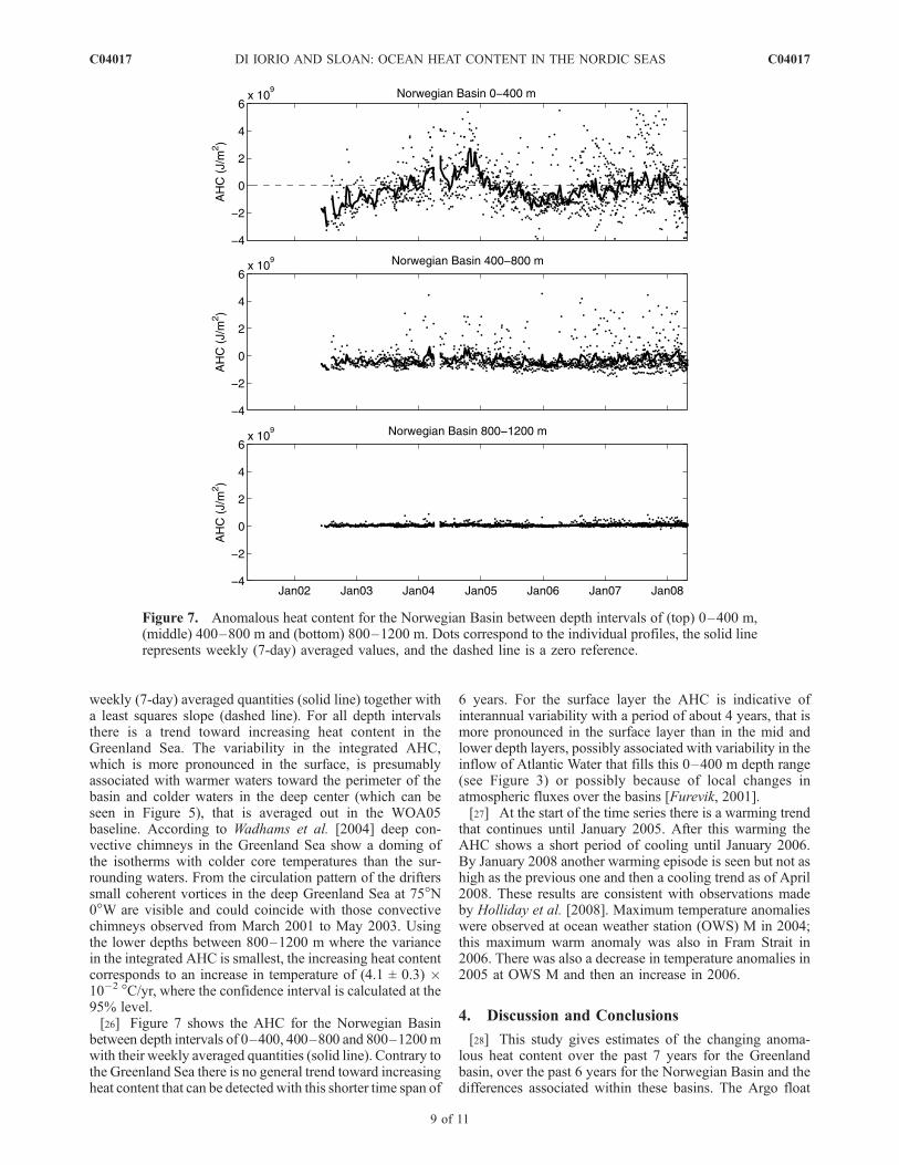
between depth intervals of 0–400, 400–800 and 800–1200 mwith their weekly averaged quantities (solid line). Contrary tothe Greenland Sea there is no general trend toward increasingheat content that can be detected with this shorter time span of
6 years. For the surface layer the AHC is indicative ofinterannual variability with a period of about 4 years, that ismore pronounced in the surface layer than in the mid andlower depth layers, possibly associated with variability in theinflow of Atlantic Water that fills this 0–400 m depth range(see Figure 3) or possibly because of local changes inatmospheric fluxes over the basins [Furevik, 2001].[27] At the start of the time series there is a warming trend
that continues until January 2005. After this warming theAHC shows a short period of cooling until January 2006.By January 2008 another warming episode is seen but not ashigh as the previous one and then a cooling trend as of April2008. These results are consistent with observations madeby Holliday et al. [2008]. Maximum temperature anomalieswere observed at ocean weather station (OWS) M in 2004;this maximum warm anomaly was also in Fram Strait in2006. There was also a decrease in temperature anomalies in2005 at OWS M and then an increase in 2006.
4. Discussion and Conclusions
[28] This study gives estimates of the changing anoma-lous heat content over the past 7 years for the Greenlandbasin, over the past 6 years for the Norwegian Basin and thedifferences associated within these basins. The Argo float
Figure 7. Anomalous heat content for the Norwegian Basin between depth intervals of (top) 0–400 m,(middle) 400–800 m and (bottom) 800–1200 m. Dots correspond to the individual profiles, the solid linerepresents weekly (7-day) averaged values, and the dashed line is a zero reference.
C04017 DI IORIO AND SLOAN: OCEAN HEAT CONTENT IN THE NORDIC SEAS
9 of 11
C04017
data clearly depicts the seasonal variability in heat content forthe Greenland and Iceland Seas and the Norwegian Basin; thisseasonal variability is closely represented by the spatiallyaveraged WOA05 climatological data. By using a spatiallyaveraged climatological heat content, as opposed to a linearlyinterpolated value at theArgo location, wewere able to removean observed seasonal cycle (not shown) from the anomalousheat content. TheGreenland Sea shows increasing heat contentover the 1200 m depth range for the past 7 years thatcorresponds to a temperature rise of 0.04�C/yr.[29] The Norwegian Basin shows a maximum AHC in the
surface layer during the year 2004 which is consistent withthe findings in the International Council for the Explorationof the sea cooperative research report [ICES, 2005]. In thisannual climate summary, the working group document thatthe core of Atlantic Water along the Norwegian continentalslope was 0.5–0.8�C warmer than normal. In fact theobserved change in AHC for the upper layer of theNorwegian Basin corresponds to a change of 0.6�C.[30] Many researchers have tried to link interannual
variability in the North Atlantic and Nordic seas in termsof atmospheric variability parameterized by the NorthAtlantic Oscillation (NAO) because it has a significantimpact on oceanic [Schlichtholz and Goszczko, 2005; Orviket al., 2001; Mork and Blindheim, 2000; Mauritzen et al.,2006] and ecological [see, e.g., Skogen et al., 2007] con-ditions. According to Mauritzen et al. [2006] the inflow ofAtlantic water to the Nordic seas increases immediately inresponse to an increase in the NAO. Orvik et al. [2001]document a high inflow of Atlantic water through the FaroeShetland channel (eastern branch of the NwAC) that coin-cides with a high NAO+ index, implying that variabilities ofthe Atlantic inflow are related to the westerly wind field ofthe North Atlantic. During a positive phase (NAO+), adeepened Icelandic low causes strong westerlies over theeastern North Atlantic which then forces a large northwardtransport in the North Atlantic and a subsequent strongAtlantic inflow to the eastern Norwegian Sea. The westernbranch of the NwAC, however, was found to have anegative correlation between salinity and the NAO (Nilsenand Nilsen [2007], and consistent with the findings ofBlindheim et al. [2000]), but temperature did not showany significant changes with the NAO suggesting atmo-spheric heat fluxes’ dominant influence in the upper layers.Furevik [2001] also indicates that a reduced oceanic heat
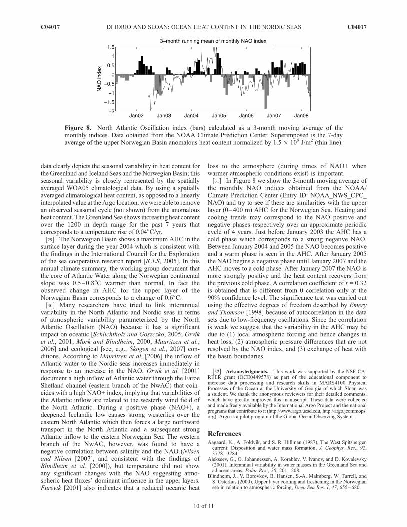
loss to the atmosphere (during times of NAO+ whenwarmer atmospheric conditions exist) is important.[31] In Figure 8 we show the 3-month moving average of
the monthly NAO indices obtained from the NOAA/Climate Prediction Center (Entry ID: NOAA_NWS_CPC_NAO) and try to see if there are similarities with the upperlayer (0–400 m) AHC for the Norwegian Sea. Heating andcooling trends may correspond to the NAO positive andnegative phases respectively over an approximate periodiccycle of 4 years. Just before January 2003 the AHC has acold phase which corresponds to a strong negative NAO.Between January 2004 and 2005 the NAO becomes positiveand a warm phase is seen in the AHC. After January 2005the NAO begins a negative phase until January 2007 and theAHC moves to a cold phase. After January 2007 the NAO ismore strongly positive and the heat content recovers fromthe previous cold phase. A correlation coefficient of r = 0.32is obtained that is different from 0 correlation only at the90% confidence level. The significance test was carried outusing the effective degrees of freedom described by Emeryand Thomson [1998] because of autocorrelation in the datasets due to low-frequency oscillations. Since the correlationis weak we suggest that the variability in the AHC may bedue to (1) local atmospheric forcing and hence changes inheat loss, (2) atmospheric pressure differences that are notresolved by the NAO index, and (3) exchange of heat withthe basin boundaries.
[32] Acknowledgments. This work was supported by the NSF CA-REER grant (OCE0449578) as part of the educational component toincrease data processing and research skills in MARS4100 PhysicalProcesses of the Ocean at the University of Georgia of which Sloan wasa student. We thank the anonymous reviewers for their detailed comments,which have greatly improved this manuscript. These data were collectedand made freely available by the International Argo Project and the nationalprograms that contribute to it (http://www.argo.ucsd.edu, http://argo.jcommops.org). Argo is a pilot program of the Global Ocean Observing System.
ReferencesAagaard, K., A. Foldvik, and S. R. Hillman (1987), The West Spitsbergencurrent: Disposition and water mass formation, J. Geophys. Res., 92,3778–3784.
Alekseev, G., O. Johannessen, A. Korablev, V. Ivanov, and D. Kovalevsky(2001), Interannual variability in water masses in the Greenland Sea andadjacent areas, Polar Res., 20, 201–208.
Blindheim, J., V. Borovkov, B. Hansen, S.-A. Malmberg, W. Turrell, andS. Osterhus (2000), Upper layer cooling and freshening in the Norwegiansea in relation to atmospheric forcing, Deep Sea Res. I, 47, 655–680.
Figure 8. North Atlantic Oscillation index (bars) calculated as a 3-month moving average of themonthly indices. Data obtained from the NOAA Climate Prediction Center. Superimposed is the 7-dayaverage of the upper Norwegian Basin anomalous heat content normalized by 1.5 � 109 J/m2 (thin line).
C04017 DI IORIO AND SLOAN: OCEAN HEAT CONTENT IN THE NORDIC SEAS
10 of 11
C04017
Bonisch, G., J. Blindheim, J. Bullister, P. Schlosser, and D. Wallace (1997),Long-term trends of temperature, salinity, density, and transient tracers inthe central Greenland Sea, J. Geophys. Res., 102, 18,553–18,571.
Bourke, R. H., J. L. Newton, R. G. Paquette, and M. D. Tunnicliffe (1987),Circulation and water masses of the East Greenland Shelf, J. Geophys.Res., 92, 6729–6740.
Bourke, R. H., A. H. Wiegel, and R. G. Paquette (1988), The westwardturning branch of the West Spitsbergen Current, J. Geophys. Res., 93,14,065–14,077.
Emery, W., and R. Thomson (1998), Data Analysis Methods in PhysicalOceanography, Elsevier, New York.
Furevik, T. (2001), Annual and interannual variability of Atlantic Watertemperatures in the Norwegian and Barents Seas: 1980–1996, Deep SeaRes. Part I, 48, 383–404.
GSP Group (1990), A venture towards improved understanding of theocean’s role in climate, Eos Trans. AGU, 71(24), 750–751, 754–755.
Holliday, N., et al. (2008), Reversal of the 1960s to 1990s freshening trendin the northeast North Atlantic and Nordic seas, Geophys. Res. Lett., 35,L03614, doi:10.1029/2007GL032675.
Hurrell, J. (1995), Decadal trends in the North Atlantic Oscillation: Regio-nal temperatures and precipitation, Science, 269, 676–679.
ICES (2005), The annual ICES Ocean Climate Status Summary 2004/2005,in ICES Cooperative Research Report, Rep. 275, 37 pp., Copenhagen,Den.
Isachsen, P., C. Mauritzen, and H. Svendsen (2007), Dense water formationin the Nordic seas diagnosed from sea surface buoyancy fluxes, Deep SeaRes. Part I, 54, 22–41.
Ivchenko, V., N. Wells, and D. Aleynikr (2006), Anomaly of heat content inthe Northern Atlantic in the last 7 years: Is the ocean warming or cool-ing?, Geophys. Res. Lett., 33, L22606, doi:10.1029/2006GL027691.
Jakobsen, P., M. Ribergaard, D. Quadfasel, T. Schmith, and C. Hughes(2003), Near surface circulation in the northern North Atlantic as inferredfrom Lagrangian drifters: Variability from the mesoscale to interannual,J. Geophys. Res., 108(C8), 3251, doi:10.1029/2002JC001554.
Jakobsson, M., R. Macnab, L. Mayer, R. Anderson, M. Edwards, J. Hatzky,H. W. Schenke, and P. Johnson (2008), An improved bathymetric por-trayal of the Arctic Ocean: Implications for ocean modeling and geolo-gical, geophysical and oceanographic analyses, Geophys. Res. Lett., 108,L07602, doi:10.1029/2008GL033520.
Karstensen, J., P. Schlosser, D. Wallace, J. Bullister, and J. Blindheim(2005), Water mass transformation in the Greenland Sea during the1990s, J. Geophys. Res., 110, C07022, doi:10.1029/2004JC002510.
Locarnini, R., A. Mishonov, J. Antonov, T. Boyer, and H. Garcia (2006),World ocean atlas 2005, volume I: Temperature, in NOAA Atlas NESDIS62, edited by S. Levitus, 182 pp., U.S. Gov. Print. Off., Washington, D. C.
Mauritzen, C. (1996a), Production of dense overflow waters feeding theNorth Atlantic across the Greenland-Scotland Ridge. part 1: Evidence fora revised circulation scheme, Deep Sea Res. Part I, 43, 769–806.
Mauritzen, C. (1996b), Production of dense overflow waters feeding theNorth Atlantic across the Greenland-Scotland Ridge. part 2: An inversemodel, Deep Sea Res. Part I, 43, 807–835.
Mauritzen, C., S. Hjollo, and A. Sando (2006), Passive tracers and activedynamics: A model study of hydrography and circulation in the northernNorth Atlantic, J. Geophys. Res., 111, C08014, doi:10.1029/2005JC003252.
Meincke, J., B. Rudels, and H. Friedrich (1997), The Arctic Ocean-Nordicseas thermohaline system, ICES J. Mar. Sci., 54, 283–299.
Mork, K., and J. Blindheim (2000), Variations in the Atlantic inflow to theNordic seas, 1955–1996, Deep Sea Res. Part I, 47, 1035–1057.
Nilsen, J., and E. Falck (2006), Variations of mixed layer properties in theNorwegian Sea for the period 1948–1999, Prog. Oceanogr., 70, 58–90.
Nilsen, J., and F. Nilsen (2007), The Atlantic Water flow along the VoringPlateau: Detecting frontal structures in oceanic station time series, DeepSea Res. Part I, 54, 297–319.
Nost, O., and P. Isachsen (2003), The large-scale time-mean ocean circula-tion in the Nordic seas and arctic ocean estimated from simplified dy-namics, J. Mar. Res., 61, 175–210.
Orvik, K. (2004), The deepening of the Atlantic water in the Lofoten Basinof the Norwegian Sea, demonstrated by using an active reduced gravitymodel, Geophys. Res. Lett., 31, L01306, doi:10.1029/2003GL018687.
Orvik, K., and P. Niiler (2002), Major pathways of Atlantic water in thenorthern North Atlantic and Nordic seas toward Arctic, Geophys. Res.Lett., 29(19), 1896, doi:10.1029/2002GL015002.
Orvik, K., O. Skagseth, and M. Mork (2001), Atlantic inflow to the Nordicseas: Current structure and volume fluxes from moored current meters,VM-ADCP and SeaSoar-CTD observations, 1995–1999, Deep Sea Res.Part I, 48, 937–957.
Park, J., K. Kim, B. King, and S. Riser (2005), An advanced method toestimate deep currents from profiling floats, J. Atmos. Ocean. Technol.,22, 1294–1304.
Piechura, J., A. Beszczynska-Moller, and R. Osinski (2001), Volume, heatand salt transport by the West Spitsbergen Current, Polar Res., 20, 233–240.
Poulain, P.-M., A. Warn-Varnas, and P. Niiler (1996), Near-surface circula-tion of the Nordic seas as measured by Lagrangian drifters, J. Geophys.Res., 101, 18,237–18,258.
Saloranta, T., and P. Haugan (2004), Northward cooling and freshening ofthe warm core of the West Spitsbergen Current, Polar Res., 23(1), 79–88.
Schlichtholz, P., and I. Goszczko (2005), Was the Atlantic water tempera-ture in the West Spitsbergen Current predictable in the 1990s?, Geophys.Res. Lett., 32, L04610, doi:10.1029/2004GL021724.
Skogen, M., W. Budgell, and F. Rey (2007), Interannual variability inNordic seas primary production, ICES J. Mar. Sci., 64, 889–898.
Visbeck, M., and M. Rhein (2000), Is bottom boundary layer mixing slowlyventilating Greenland Sea deep water?, J. Phys. Oceanogr., 30, 215–224.
Wadhams, P., G. Budeus, J. Wikinson, T. Loyning, and V. Pavlov (2004),The multi-year development of long-lived convective chimneys in theGreenland Sea, Geophys. Res. Lett., 31, L06306, doi:10.1029/2003GL019017.
Walter, M. (2004), Warming of Greenland Sea deep water induced byabyssal mixing, Ph.D. dissertation, Univ. of Bremen, Bremen, Germany.
Watson, A., et al. (1999), Mixing and convection in the Greenland Sea froma tracer-release experiment, Nature, 401, 902–904.
Willis, J. K., J. M. Lyman, G. C. Johnson, and J. Gilson (2007), Correctionto ‘‘Recent cooling of the upper ocean’’, Geophys. Res. Lett., 34, L16601,doi:10.1029/2007GL030323.
Wong, A., R. Keeley, T. Carval, and the Argo Data Management Team(2008), Argo quality control manual, version 2.31, Argo Data Manage-ment, technical report, 11 April. (Available at: http://www.coriolis.eu.org/cdc/argo_rfc.htm)
�����������������������D. Di Iorio and C. Sloan, Department of Marine Sciences, University
of Georgia, 250 Marine Sciences Building, Athens, GA 30602, USA.([email protected])
C04017 DI IORIO AND SLOAN: OCEAN HEAT CONTENT IN THE NORDIC SEAS
11 of 11
C04017


