Embed Size (px)
Citation preview

Seediscussions,stats,andauthorprofilesforthispublicationat:https://www.researchgate.net/publication/238581724
TheMesoproterozoicIrumidebeltofZambia
ARTICLEinJOURNALOFAFRICANEARTHSCIENCES·SEPTEMBER2006
ImpactFactor:1.4·DOI:10.1016/j.jafrearsci.2006.01.018
CITATIONS
37
READS
47
4AUTHORS,INCLUDING:
BertDeWaele
SRKConsulting,Perth,AustraliaandAdjun…
99PUBLICATIONS2,477CITATIONS
SEEPROFILE
BenjaminMapani
UniversityofNamibia
40PUBLICATIONS333CITATIONS
SEEPROFILE
FrancisTembo
JapanAgencyforMarine-EarthScienceTec…
29PUBLICATIONS539CITATIONS
SEEPROFILE
Availablefrom:BertDeWaele
Retrievedon:03February2016

www.elsevier.com/locate/jafrearsci
Journal of African Earth Sciences 46 (2006) 36–70
The Mesoproterozoic Irumide belt of Zambia
B. De Waele a,*, A.B. Kampunzu b, B.S.E. Mapani c, F. Tembo d
a Tectonics Special Research Centre, Department of Applied Geology, Curtin University of Technology, G.P.O. Box U1987,
Perth, WA 6845, Australiab Geology Department, University of Botswana, Private Bag 0022, Gaborone, Botswana
c University of Namibia, Department of Geology, Private Bag 13301, Windhoek, Namibiad Geology Department, School of Mines, University of Zambia, P.O. Box 32379, Lusaka, Zambia
Received 15 September 2003; accepted 15 January 2006Available online 14 July 2006
Abstract
The Mesoproterozoic Irumide belt is a northeast-trending structural province stretching from central Zambia to the Zambia–Tanza-nia border and northern Malawi. Mesoproterozoic and Neoproterozoic transcurrent shear zones within reactivated parts of the Palae-oproterozoic Ubendian belt define its northeastern limit. The northwestern margin is defined by the largely undeformed basementlithologies of the Bangweulu block. An intensely folded and sheared zone at the southeastern margin of the Mporokoso Group sedimen-tary depocentre on the Bangweulu block, interpreted to have developed above a thrust at the basement-cover interface, indicates thatfar-field effects of the Irumide Orogen also affected the southeastern part of the Bangweulu block sedimentary cover. To the west andsouthwest, Irumide and basement lithologies were reworked by the Damara–Lufilian–Zambezi Orogen within the Neoproterozoic Zam-bezi and Lufilian belts. The Choma–Kalomo block, previously regarded as the southwesterly continuation of the Irumide belt, is a dis-tinct Mesoproterozoic province, while a succession of structurally juxtaposed tectonic terranes in eastern Zambia record a deformationevent related to the Irumide Orogen. The lithological units identified in the Irumide belt include: (1) limited Neoarchaean rocks emplacedbetween 2.73 and 2.61 Ga and representing the oldest rocks in the Bangweulu block; (2) ca. 2.05–1.85 Ga volcano-plutonic complexesand gneisses representing the most important components in the Bangweulu block; (3) an extensive quartzite–metapelite succession withminor carbonate forming the Muva Supergroup, and deposited at ca. 1.85 Ga; (4) granitoids emplaced between 1.65 and 1.55 Ga; (5) aminor suite of anorogenic plutons (nepheline syenite and biotite granite) restricted to the far northeastern Irumide belt and emplacedbetween 1.36 and 1.33 Ga; (6) voluminous syn- to post-kinematic Irumide granitoids emplaced between 1.05 and 0.95 Ga. Crustal short-ening and thickening in the Irumide belt are shown by northwestward-directed thrusts and related folds and metamorphic paragenesesrecording a clockwise medium-pressure/medium-temperature P–T–t path. Metamorphic grades range from greenschist facies in the fore-land to the northwest to upper amphibolite facies in the southeast, with local granulites. Peak metamorphism is diachronous across thebelt and bracketed between 1.05 in the southeast and 1.02 Ga in the northwest.� 2006 Elsevier Ltd. All rights reserved.
Keywords: Irumide belt; Palaeoproterozoic Muva Supergroup; Mesoproterozoic granitoids; Bangweulu block
1. Introduction
The Irumide belt is a northeast-trending fold and thrustbelt (Fig. 1) that stretches from central Zambia, where it istruncated by the Neoproterozoic Zambezi belt, to the
1464-343X/$ - see front matter � 2006 Elsevier Ltd. All rights reserved.
doi:10.1016/j.jafrearsci.2006.01.018
* Corresponding author.E-mail address: [email protected] (B. De Waele).
Zambia–Tanzania–Malawi border in the northeast, whereit terminates against northwest-trending shear zones (Daly,1986; Theunissen et al., 1996; Klerkx et al., 1998). TheIrumide belt was first described by Ackermann (1936,1950, 1960), Ackermann and Forster (1960) and Forster(1965) who referred to the granitic basement complex inthe Irumide belt as ‘‘Die Mkushi Gneisse’’ and the exten-sive metasedimentary succession of quartzite and metapel-ite as ‘‘Die Muva’’. To the northwest of the Irumide belt, a

Fig. 1. Tectonic provinces of central and southern Africa. BB = Bangweulu block; CC = Congo Craton; CFB = Cape Fold belt (Saldania belt);CK = Choma–Kalomo block; DB=Damara belt; KB = Kibaran belt; KvC = Kaapvaal Craton; LA = Lufilian belt; LiB = Limpopo belt; LuB = Luriobelt; MaB = Magondi belt; MB = Mozambique belt; NaB = Natal belt; NB = Namaqua belt; NW = northwest Botswana Rift; RI = Rehoboth Inlier;SS = Sinclair Sequence; TC = Tanzania Craton; Ub = Ubendian belt; Ubs = Umkondo basin; UsB = Usagaran belt; ZB = Zambezi belt; ZC = Zim-babwe Craton. Dashed line shows the location of a regional cross-section in Fig. 15.
B. De Waele et al. / Journal of African Earth Sciences 46 (2006) 36–70 37
complex of granites and gneisses was ascribed to the Bang-weulu block and presumed to be of Archaean age (Forster,1965). Daly and Unrug (1982) and Andersen and Unrug(1984) extended the term Muva Supergroup to includethe sedimentary rocks of the Mporokoso Group and theKasama Formation on the Bangweulu block, and theMitoba River and Manshya River Groups and correlativesin the Irumide belt (Fig. 2). The Manshya River andKanona Group metasedimentary sequence predominantlyconsists of shallow marine deposits, whereas fluvial and
lacustrine deposits dominate the Mporokoso Group. Previ-ously, the age of sedimentation was poorly constrainedbetween the waning stages of magmatism in the Bangweulublock (ca. 1.82 Ga) and the intrusion of the Lusenga sye-nite (1145 ± 20 Ma, Brewer et al., 1979, Fig. 2, Table 1,no. 48).
The Irumide belt displays overall northwesterly tectonicvergences, placing rocks affected by Irumide deformationon top of undeformed Palaeoproterozoic (�2.05–1.85 Ga)rocks of the Bangweulu block in northern Zambia. Within

Fig. 2. Geological map of northern Zambia. Assembled and modified after Andersen and Unrug (1984) and Thieme and Johnson (1981).
38 B. De Waele et al. / Journal of African Earth Sciences 46 (2006) 36–70
the Irumide belt, metamorphic grade changes rapidlyacross strike, and this led earlier workers (Stillman, 1965;Moore, 1967) to subdivide the metasedimentary units intoan older high-grade metamorphic sequence and a youngerlow-grade sequence. De Waele and Mapani (2002) showedthat this subdivision of essentially identical stratigraphicsequences, based on differences in metamorphic gradealone, is untenable.
Over the past 10 years a large amount of new data hasbeen acquired in the Irumide belt, shedding new light onthis poorly documented structural province. This paperpresents an overview of the Irumide belt, based on previ-ously published and new geological, geochronologicaland geochemical data, and attempts to place this tectonicunit in a regional context.
2. Tectonostratigraphy and geochronology
2.1. General location of units
Fig. 2 presents a simplified geological map of the fore-land to the Irumide belt in northern Zambia. Figs. 3 and
4 are simplified maps of the southwestern and northeasternIrumide belt respectively, indicating the location of geolog-ical maps published by the Geological Survey Departmentof Zambia and used in this review. Fig. 5 is a location mapof the main geochronological data reported in the paper,and the approximate position of Figs. 2–4 and 6–10.Fig. 5 also shows the location of what in this paper istermed the Bangweulu block, Irumide belt s.s. and south-eastern Irumide belt. The large number of new U–PbSHRIMP data acquired in the Irumide belt s.s. are dis-played in Figs. 6–10, together with a few previous whole-rock Rb–Sr isochron dates used in the text. All agesreported in the text and shown on the figures are summa-rised in Table 1 where the sources of the geochronologicaldata are listed. All these data were calculated (or recalcu-lated where necessary) using decay constants of Steigerand Jager (1977).
2.2. Basement
Earlier workers have indicated that the Irumide beltoverlies an Archaean/Palaeoproterozoic basement (e.g.

Table 1Geochronological data on rocks of the Irumide belt and associated basement
No. ID Rock type Age ± error (Ma) Method Source
1 Volcanics 596 ± 10 WR Rb–Sr isochron Haslam et al. (1986)2 LW2 Luswa Syenite 943 ± 5 U–Pb SHRIMP zircon De Waele et al. (2003c)3 Lufila Granite 947 ± 89 WR Rb–Sr isochron Daly (1986)4 Kaunga Granite 970 ± 5 TIMS bulk zircon Daly (1986)5 Aplite in Luromo Granite 977 ± 1 Pb evaporation Ring et al. (1999)6 Aplite in Wililo Granite 983 ± 1 Pb evaporation Ring et al. (1999)7 SH8 Lufila Granite 1001 ± 44 U–Pb SHRIMP zircon De Waele (2005)8 Luangwa Gneiss �2033 LA–ICP–MS Cox et al. (2002)9 LW1 Chilubanama Granite 1005 ± 21 U–Pb SHRIMP zircon De Waele (2005)
10 KK1 Porphyritic granite 1003 ± 31 U–Pb SHRIMP zircon De Waele (2005)11 CHT6 Biotite granite gneiss 1005 ± 7 U–Pb SHRIMP zircon De Waele (2005)12 MTG4 Chilubanama Granite 1010 ± 11 U–Pb SHRIMP zircon De Waele et al. (2003c)
MTG4� Chilubanama Granite 1004 ± 16 U–Pb SHRIMP zircon De Waele et al. (2003c)13 SER6-6 Lukusahi migmatite 1018 ± 5 U–Pb SHRIMP zircon De Waele et al. (2003c)14 SASA2 Sasa Granite 1016 ± 14 U–Pb SHRIMP zircon De Waele et al. (2003c)15 CHL5 Granite gneiss 1016 ± 17 U–Pb SHRIMP zircon De Waele (2005)16 SER6-7� Fukwe Migmatite 1021 ± 16 U–Pb SHRIMP zircon De Waele et al. (2003c)
SER6-7� Fukwe Migmatite 554 ± 20 U–Pb SHRIMP zircon De Waele (2005)17 KN8 Biotite granite gneiss 1022 ± 16 U–Pb SHRIMP zircon De Waele (2005)18 ND1 Porphyritic granite 1023 ± 7 U–Pb SHRIMP zircon De Waele (2005)19 ZM36 Mununga Quarry Granite 1025 ± 10 U–Pb SHRIMP zircon De Waele et al. (2003c)20 MTGG1 Mutangoshi Gneissic Granite 1027 ± 13 U–Pb SHRIMP zircon De Waele et al. (2003c)21 ND5 Syeno-granite 1028 ± 7 U–Pb SHRIMP zircon De Waele (2005)22 MH9C Porphyritic granite 1029 ± 14 U–Pb SHRIMP zircon De Waele (2005)23 KN2A Porphyritic granite 1031 ± 14 U–Pb SHRIMP zircon De Waele (2005)24 MH4 Porphyritic granite 1017 ± 19 U–Pb SHRIMP zircon De Waele (2005)25 SQG Serenje Quarry Granite 1024 ± 9 U–Pb SHRIMP zircon De Waele et al. (2003c)26 SER5-3 Porphyritic granite 1034 ± 5 U–Pb SHRIMP zircon De Waele et al. (2003c)27 CC8 Porphyritic granite 1035 ± 12 U–Pb SHRIMP zircon De Waele (2005)28 SER6-4 Porphyritic granite 1036 ± 13 U–Pb SHRIMP zircon De Waele et al. (2003c)29 ND4 Granodiorite 1035 ± 19 U–Pb SHRIMP zircon De Waele (2005)30 CC5 Porphyritic granite 1038 ± 17 U–Pb SHRIMP zircon De Waele (2005)31 FW1 Porphyritic granite 1038 ± 58 U–Pb SHRIMP zircon De Waele (2005)32 ZAM5 Chipata Granite 1041 ± 9 U–Pb SHRIMP zircon De Waele (2005)33 Luangwa gneiss 1043 ± 19 LA–ICP–MS Cox et al. (2002)34 Chipata granulite 1046 ± 3 TIMS single monazite Schenk and Appel (2001)35 ZAM1 Chipata granulite 1047 ± 20 U–Pb SHRIMP zircon De Waele (2005)36 KN7 Porphyritic granite 1048 ± 10 U–Pb SHRIMP zircon De Waele (2005)37 ZAM4 Chipata Granite 1050 ± 10 U–Pb SHRIMP zircon De Waele (2005)38 KN5 Biotite granite gneiss 1053 ± 14 U–Pb SHRIMP zircon De Waele (2005)39 MTGG2 Mutangoshi Gneissic Granite 1055 ± 13 U–Pb SHRIMP zircon De Waele et al. (2003c)40 ZAM3 Chipata Granite 1076 ± 3 U–Pb SHRIMP zircon De Waele (2005)41 Lwakwa granite 1087 ± 11 TIMS single zircon Ring et al. (1999)42 Mkushi gneiss 1088 ± 159 U–Pb SHRIMP zircon Rainaud et al. (2002)43 Luromo granite 1108 ± 1 Pb evaporation Ring et al. (1999)44 Wililo granite 1115 ± 1 Pb evaporation Ring et al. (1999)45 Wililo granite 1116 ± 1 Pb evaporation Ring et al. (1999)46 Wililo granite 1118 ± 1 Pb evaporation Ring et al. (1999)47 Mwenga granite 1119 ± 20 TIMS single zircon Ring et al. (1999)48 Lusenga syenite 1145 ± 20 WR Rb–Sr isochron Brewer et al. (1979)49 Semahwa gneiss 1198 ± 6 TIMS bulk zircon Hanson et al. (1988)50 Chilala gneiss 1285 ± 64 TIMS bulk zircon Hanson et al. (1988)51 Ntendele metatonalite 1329 ± 1 Pb evaporation Vrana et al. (2004)52 Mivula syenite 1341 ± 16 WR Rb–Sr isochron Tembo (1986)53 Zongwe gneiss 1343 ± 6 TIMS bulk zircon Hanson et al. (1988)54 Siasikabole granite 1352 ± 14 TIMS bulk zircon Hanson et al. (1988)55 Mivula syenite 1360 ± 1 Pb evaporation Vrana et al. (2004)56 Mutangoshi gneiss 1407 ± 33 WR Rb–Sr isochron Daly (1986)57 ML2 Lubu Granite Gneiss 1551 ± 33 U–Pb SHRIMP zircon De Waele et al. (2003c)58 LW10 Musalango Gneiss 1610 ± 26 U–Pb SHRIMP zircon De Waele et al. (2003c)59 ND2 Granite gneiss 1627 ± 12 U–Pb SHRIMP zircon De Waele (2005)60 SR12 Lukamfwa Hill Granite Gneiss 1639 ± 14 U–Pb SHRIMP zircon De Waele et al. (2003c)61 SER6-3 Lukamfwa Hill Granite Gneiss 1652 ± 6 U–Pb SHRIMP zircon De Waele et al. (2003c)62 SER6-2 Lukamfwa Hill Granite Gneiss 1664 ± 4 U–Pb SHRIMP zircon De Waele et al. (2003c)
(continued on next page)
B. De Waele et al. / Journal of African Earth Sciences 46 (2006) 36–70 39

Table 1 (continued)
No. ID Rock type Age ± error (Ma) Method Source
63 Luchewe granite 1780 ± 250 WR Rb–Sr isochron Schandelmeier (1980)64 Mansa volcanic 1815 ± 29 WR Rb–Sr isochron Brewer et al. (1979)65 Kate granite 1830 ± 85 WR Rb–Sr isochron Schandelmeier (1980)66 Mansa granite 1832 ± 32 WR Rb–Sr isochron Brewer et al. (1979)67 IS20 Kachinga Tuff 1856 ± 4 U–Pb SHRIMP zircon De Waele (2005)68 MA1 Mansa Granite 1860 ± 13 U–Pb SHRIMP zircon De Waele (2005)69 MA5 Mansa Volcanic 1862 ± 19 U–Pb SHRIMP zircon De Waele (2005)70 MA2 Mansa granite 1862 ± 8 U–Pb SHRIMP zircon De Waele (2005)71 MA9 Musonda Falls Granite 1866 ± 9 U–Pb SHRIMP zircon De Waele (2005)72 MA3 Mansa Volcanic 1868 ± 7 U–Pb SHRIMP zircon De Waele (2005)73 KB5 Katibunga Basalt 1871 ± 24 U–Pb SHRIMP zircon De Waele (2005)74 Kinsenda Lufubu schist 1873 ± 8 U–Pb SHRIMP zircon Rainaud et al. (2002)75 Solwezi granite 1874 ± 9 TIMS single zircon John (2001)76 Mambwe gneiss 1877 ± 55 WR Rb–Sr isochron Schandelmeier (1980)77 ZM31 Luswa River Tuff 1879 ± 13 U–Pb SHRIMP zircon De Waele (2005)78 Kinsenda granite (Luina dome) 1882 ± 20 TIMS single zircon Ngoyi et al. (1991)79 Kabompo granite 1884 ± 10 TIMS single zircon John (2001)80 ISK2 Luwalizi Granite Gneiss 1927 ± 10 U–Pb SHRIMP zircon De Waele (2005)81 Nyika granite 1932 ± 9 TIMS bulk zircon Dodson et al. (1975)82 ISK1 Luwalizi Granite Gneiss 1942 ± 6 U–Pb SHRIMP zircon De Waele (2005)83 CC10 Porphyritic granite gneiss 1953 ± 6 U–Pb SHRIMP zircon De Waele (2005)84 Biotite metatonalite 1961 ± 1 Pb evaporation Vrana et al. (2004)85 Samba porphyry 1964 ± 12 U–Pb SHRIMP zircon Rainaud et al. (2002)86 Lufubu schist 1970 ± 10 U–Pb SHRIMP zircon Rainaud et al. (2002)87 Nyika granite 1969 ± 1 Pb evaporation Ring et al. (1997)88 ZAM2 Lutembwe River Granulite 1974 ± 18 U–Pb SHRIMP zircon De Waele (2005)89 Mulungushi gneiss 1976 ± 5 U–Pb SHRIMP zircon Rainaud et al. (2002)90 Chambishi granite 1980 ± 7 U–Pb SHRIMP zircon Rainaud et al. (2002)91 Chambishi granite 1983 ± 5 U–Pb SHRIMP zircon Rainaud et al. (2002)92 Rumphi granite 1988 ± 1 Pb evaporation Ring et al. (1997)93 Mufulira granite 1991 ± 3 U–Pb SHRIMP zircon Rainaud et al. (2002)94 Chelinda granite 1995 ± 1 Pb evaporation Ring et al. (1997)95 Luromo granite 2002 ± 1 Pb evaporation Ring et al. (1997)96 Luangwa granite �2033 LA–ICP–MS Cox et al. (2002)97 MK3 Mkushi Gneiss 2042 ± 10 U–Pb SHRIMP zircon De Waele (2005)98 MK5 Mkushi Gneiss 2029 ± 7 U–Pb SHRIMP zircon De Waele (2005)
MK5 Mkushi Gneiss 2050 ± 9 U–Pb SHRIMP zircon99 KN1 Mkushi Gneiss 2036 ± 6 U–Pb SHRIMP zircon De Waele (2005)
100 Rumphi granite 2048 ± 1 Pb evaporation Ring et al. (1997)101 Mkushi gneiss 2049 ± 6 U–Pb SHRIMP zircon Rainaud et al. (2002)102 Mwinilunga granite 2058 ± 7 U–Pb SHRIMP zircon Key et al. (2001)103 Luromo granite 2093 ± 1 Pb evaporation Ring et al. (1997)104 Luromo granite 2224 ± 1 Pb evaporation Ring et al. (1997)105 Mwinilunga granite 2538 ± 10 U–Pb SHRIMP zircon Key et al. (2001)106 Mwinilunga granite 2543 ± 5 U–Pb SHRIMP zircon Key et al. (2001)107 Mwinilunga granite 2561 ± 10 U–Pb SHRIMP zircon Key et al. (2001)108 Luangwa gneiss 2608 ± 14 LA–ICP–MS Cox et al. (2002)109 KMP1 Kapiri Mposhi Granite 2726 ± 36 U–Pb SHRIMP zircon De Waele (2005)110 Chembewesu Quartzite Detrital U–Pb SHRIMP zircon De Waele (2005)111 Mufulira quartzite Detrital U–Pb SHRIMP zircon Rainaud et al. (2002)112 Kasama quartzite Detrital U–Pb SHRIMP zircon De Waele (2005)113 Mansa quartzite Detrital U–Pb SHRIMP zircon De Waele (2005)
Ages interpreted to date peak metamorphism are in italics.No. refers to numbers mentioned in the text, ID refers to sample names of own samples.
40 B. De Waele et al. / Journal of African Earth Sciences 46 (2006) 36–70
Drysdall et al., 1972; Daly, 1986). An extensive set of newsensitive high-mass resolution ion microprobe (SHRIMP)U–Pb zircon geochronological data (Table 1) is used in thispaper to constrain the age of crustal rocks affected by theIrumide contractional deformation and those exposed inthe Irumide foreland. The main basement lithologiesexposed in and adjacent to the Irumide belt are described
below according to geographic location, from the northeast(the Bangweulu block and related basement lithologies inthe Irumide belt, Fig. 2) to the centre (basement lithologiesin the Irumide belt s.s., Figs. 3, 4, 6–10), southwest (Domesof the Copperbelt area, Fig. 5) and southeast (LutembweGranulite near Chipata and the Nyika Granite (NG),Fig. 5) near the Malawi border. This section includes data

Fig. 3. Overview map of the southwestern Irumide belt, showing simplified geology and the location of mapped quarter-degree sheets. The simplifiedgeology is adapted from the 1:1,000,000 geological map of Zambia (Thieme and Johnson, 1981).
B. De Waele et al. / Journal of African Earth Sciences 46 (2006) 36–70 41
related to correlative basement units within the Irumidebelt and Copperbelt (outside the Irumide belt s.s.) thathave a major bearing on proving that basement lithologiesunderlie large portions of the Irumide belt.
2.2.1. Bangweulu block
The Bangweulu block comprises three distinct lithotec-tonic units (Fig. 2): (1) a series of northwest-trendinghigh-grade metapelites exposed in northeast Zambia andwithin the Palaeoproterozoic Ubendian belt; (b) a seriesof east–west-trending schist belts on the Bangweulu blockknown as the Mulungwizi Gneisses (Namateba, 1994;Van Tuijl and Verhoog, 1995; Verhoog and Van Tuijl,1995a,b,c); (c) an extensive suite of plutono-volcanicsoverlain by the supracrustal Mporokoso Group metasedi-mentary sequence (Andersen and Unrug, 1984; Andrews-Speed, 1989).
The main lithology of the Mulungwizi Gneiss consists ofmigmatitic biotite gneiss, with minor biotite-epidote andmuscovite gneiss, associated with mica-schist, amphiboliteand quartzite. The main fabric of the Mulungwizi Gneiss
strikes east–southeast with steep dips to both the north–northeast and south–southwest. The Mulungwizi Gneiss isreported to pass eastwards into Palaeoproterozoic gneissof the Ubendian belt with no obvious break; they are there-fore inferred to be correlatives (Namateba, 1994; Van Tuijland Verhoog, 1995; Verhoog and Van Tuijl, 1995a,b,c).Pelitic schist belts exposed farther west in the Bangweulublock display a similar east–southeast-fabric to the Mulung-wizi Gneiss, from which they are separated by relativelyundeformed granitoids of the Bangweulu block, one ofwhich yielded a Rb–Sr date of 1877 ± 55 Ma (Schandelme-ier, 1981, see Fig. 5 and Table 1, no. 76). The schist belts areinterpreted as vestiges of the Palaeoproterozoic Ubendianbelt in the Bangweulu block (Namateba, 1994; Van Tuijland Verhoog, 1995; Verhoog and Van Tuijl, 1995a,b,c).
In the northwestern part of the Bangweulu block, thecontact between plutono-volcanic rocks and the Mporok-oso Group supracrustal metasedimentary sequence is ahigh-strain zone, locally known as the Luongo Shear Zone(Fig. 2). The Bangweulu block high-K calc-alkaline felsicigneous rocks represent a continental arc related to the

Fig. 4. Overview map of the northeastern Irumide belt, showing simplified geology and the location of mapped quarter-degree sheets. The simplifiedgeology is adapted from the 1:1,000,000 geological map of Zambia (Thieme and Johnson, 1981).
42 B. De Waele et al. / Journal of African Earth Sciences 46 (2006) 36–70

Fig. 5. Overview of previously published Proterozoic age data for Zambia (refer to Table 1 for sources of data). The locations of Figs. 2–4 and 6–10 areindicated.
B. De Waele et al. / Journal of African Earth Sciences 46 (2006) 36–70 43
Ubendian belt (Brewer et al., 1979; Andersen and Unrug,1984; Kabengele et al., 1991). Rb–Sr whole-rock dates ongranitoids and rhyolites suggest the emplacement of thesuite between 1.88 and 1.82 Ga (Brewer et al., 1979;Schandelmeier, 1981, 1983, Fig. 5, Table 1, nos. 63–66and 76). SHRIMP U–Pb zircon dating of Bangweulu blockigneous rocks exposed near Mansa (Fig. 2) yielded dates of1860 ± 13, 1862 ± 8 and 1866 ± 9 Ma for granitoids and1868 ± 7 and 1862 ± 19 Ma for rhyolites (De Waeleet al., 2003b, 2005; De Waele and Fitzsimons, submittedfor publication, Table 1, nos. 68–72). These dates supersedeprevious estimates on the emplacement of these granitesand associated volcanic rocks (Brewer et al., 1979).
Two granites exposed within the northeastern part ofthe Irumide belt (the Luwalizi Granite near Isoka, Fig. 4)yielded SHRIMP U–Pb zircon dates of 1942 ± 6 and1927 ± 10 Ma (De Waele et al., 2003b; De Waele and Fitz-simons, submitted for publication, Fig. 10, Table 1, nos. 80and 82) and form part of a Palaeoproterozoic basement tothe Irumide belt. The Luwalizi granites are mildlydeformed biotite granites, and are structurally overlain by
the Manshya River Group metasedimentary succession ofthe northeastern Irumide belt.
2.2.2. Mkushi Gneiss Complex
The Mkushi Gneiss Complex comprises banded biotitegneisses, augen gneisses and porphyritic granite gneisses,collectively known as the Mkushi Gneiss, underlying thesouthwestern Irumide belt (Stillman, 1965, Figs. 6 and 7).The Mkushi Gneiss yielded a SHRIMP U–Pb zircon igne-ous crystallisation age of 2049 ± 6 Ma on a sample fromthe Munshiwemba Quarry south of Mkushi (Rainaudet al., 2002, 2003, Fig. 6, Table 1, no. 101). At Mun-shiwemba Quarry, the Mkushi Gneiss is a highly shearedbiotite-rich, coarse porphyritic and medium-grained gran-ite, which yielded SHRIMP U–Pb zircon dates of2042 ± 10 and 2029 ± 7 Ma (De Waele et al., 2003a,b,Fig. 6, Table 1, nos. 97 and 98). It is cut by aplite veins con-taining inherited zircons with cores yielding the same dateas the Mkushi Gneiss, and magmatic overgrowths yieldinga low-precision date of 1088 ± 159 Ma (Rainaud et al.,2002, 2003, 2005, Fig. 6, Table 1, no. 42). Farther to the

Fig. 6. Simplified geological map of the area around Mkushi, based on published 1:100,000 scale geological maps; includes Kapiri Mposhi, Kakulu(Mulungushi), Mita Hills, Mkushi, Musofu River, Fiwila and Ndabala map sheets and parts of Serenje, Chin’gombe, Luano and Bwana Mkubwa mapsheets (Stillman, 1965; Smith, 1966; Moore, 1967; Cvetcovic, 1973; Kerr, 1975; Smith and Kerr, 1975; Reichwalder and Brandon, 1992; Mapani andMoore, 1995; Carruthers, 2000; Chisela, 2000).
44 B. De Waele et al. / Journal of African Earth Sciences 46 (2006) 36–70
southwest, a megacrystic granite yielded a SHRIMP U–Pbzircon igneous crystallisation age of 1976 ± 5 Ma (Rainaudet al., 2002, Fig. 6, Table 1, no. 89). To the northeast, a bio-tite granite gneiss in the Kanona area yielded a SHRIMPU–Pb zircon igneous crystallisation age of 2036 ± 6 Ma(Fig. 7, Table 1, no. 99), while to the southeast of the Mun-shiwemba Quarry, a porphyritic biotite granite gneiss fromChin’gombe Mission was emplaced at 1953 ± 6 Ma (De
Waele et al., 2003a,b, Fig. 6, Table 1, no. 83). The datain Table 1 confirm the presence of a Palaeoproterozoic(2.05–1.95 Ga) basement throughout the southwestern Iru-mide belt, which is collectively ascribed to the MkushiGneiss Complex. Granitoids intruding the Mkushi GneissComplex and previously mapped as part of this complex(Smith, 1966; Cvetcovic, 1973; Page, 1973; Kerr, 1975;Smith and Kerr, 1975) yielded SHRIMP U–Pb zircon

Fig. 7. Simplified geological map of the region around Kanona, adapted from published 1:100,000 scale geological maps; includes Kasanka (mapped fromsatellite imagery), Serenje, Kanona, Chitambo, and Mupamadzi sheets (Cordiner, 1977; Mapani and Moore, 1995; Van de Velde and De Waele, 1997;Cordiner, 2000).
B. De Waele et al. / Journal of African Earth Sciences 46 (2006) 36–70 45
igneous crystallisation ages of ca. 1.65 and 1.05–1.02 Ga(De Waele et al., 2003c).
2.2.3. Copperbelt domes
In the Copperbelt, basement ‘‘Domes’’ (Fig. 5) containmigmatites, gneisses and deformed granites exposed inthe Lushwishi, Konkola, Luina, Solwezi, Mwombeshiand Kabompo Domes in Zambia and southern Katanga(Democratic Republic of Congo, hereafter DRC). TheLuina Dome granites yielded a thermal ionisation massspectrometry (TIMS) U–Pb zircon date of 1882 ± 20 Ma(Ngoyi et al., 1991, Fig. 5, Table 1, no. 78). John (2001)reported TIMS U–Pb zircon dates of 1874 ± 9 Ma for agranite of the Solwezi Dome and 1884 ± 10 Ma for a gran-ite of the Kabompo Dome (Fig. 5, Table 1, nos. 75 and 79).Rainaud et al. (2002) reported SHRIMP U–Pb zirconemplacement ages of 1991 ± 3 Ma for the Mufulira Gran-ite, 1983 ± 5 and 1980 ± 7 Ma for the granite underlyingthe Chambishi basin in the Copperbelt (Fig. 5, Table 1,nos. 90, 91 and 93). Two samples of the Lufubu metavolca-nic schist, one from DRC and one from Zambia, yieldedSHRIMP U–Pb igneous crystallisation ages of 1873 ± 8
and 1970 ± 10 Ma respectively (Rainaud et al., 2002,Fig. 5, Table 1, nos. 74 and 86 respectively). Key et al.(2001) reported SHRIMP U–Pb zircon emplacement agesof 2543 ± 5, 2561 ± 10, 2538 ± 10 and 2058 ± 7 Ma forpre-Neoproterozoic basement granitoids bounding theZambian Copperbelt to the northwest (Fig. 5, Table 1,nos. 105–107 and 102). These late Archaean granitoidswere interpreted to form part of the Congo craton in north-west Zambia (Key et al., 2001). Apart from the Neoarcha-ean lithologies in the far western portion, the Copperbeltarea appears to be underlain by a Palaeoproterozoic base-ment with igneous crystallisation ages between 2.06 and1.87 Ga.
2.2.4. Chipata area and eastern extension of the Irumide
belt
Pre-Irumide rocks exposed within the southeastern Iru-mide belt include a granodioritic gneiss from the Luangwaarea recording a laser ablation-inductively coupledplasma–mass spectrometry (LA–ICP–MS) U–Pb zircondate of 2608 ± 14 Ma (Cox et al., 2002, Fig. 5, Table 1,no. 108). A foliated granite gneiss from the same area

Fig. 8. Simplified geological map of the region around Mpika, adaptedfrom published 1:100,000 scale geological maps; includes ChilongaMission and Katibunga Mission areas and parts of Mtofwe andMupamadzi River areas (Cordiner, 1977; Mosley, 1979; Mosley andMarten, 1979; Van de Velde and De Waele, 1997).
46 B. De Waele et al. / Journal of African Earth Sciences 46 (2006) 36–70
yielded a LA–ICP–MS zircon U–Pb date of �2033 Ma(Cox et al., 2002, Fig. 5, Table 1, no. 96). The LutembweRiver granulite in the Chipata area (eastern Zambia)yielded a SHRIMP U–Pb protolith age of 1974 ± 18 Ma(De Waele, 2005, Fig. 5, Table 1, no. 88). This agesupersedes a Rb–Sr whole rock-biotite date of 2117 ±15 Ma previously reported by Liyungu and Vinyu (1996),and a low-precision Rb–Sr whole-rock date of 2290 ±240 Ma ((87Sr/86Sr)i = 0.7145 ± 0.0091) reported byHaslam et al. (1986). The Nyika granite (Malawi) yieldeda bulk U–Pb zircon date of 1932 ± 9 Ma (recalculated fromDodson et al., 1975, Fig. 5, Table 1, no. 81). Ring et al.(1997) reported a 207Pb/206Pb zircon evaporation date of1969 ± 1 Ma for a granite exposed to the north of the Nyikapluton, providing a more reliable estimate for the emplace-ment age of the suite (Fig. 5, Table 1, no. 87). Ring et al. fur-ther reported a number of 207Pb/206Pb zircon evaporationdates between 2093 and 1988 Ma in northern Malawi, andinterpreted a 207Pb/206Pb zircon date of 2002 ± 1 Ma onmetamorphic zircon to constrain peak Ubendian metamor-phism (Ring et al., 1997, Fig. 5, Table 1, nos. 92, 94, 95, 100,103 and 104). A biotite metatonalite intruding the granulitesof the Muyombe area in northeast Zambia yielded a207Pb/206Pb zircon evaporation date of 1961 ± 1 Ma (Vranaet al., 2004, Fig 5, Table 1, no. 84).
2.2.5. Summary on the basement
Basement is exposed north and northwest of the Irumidebelt and comprises of Palaeoproterozoic plutono-volcanic
rocks and gneisses emplaced between 2.05 and 1.85 Ga.This basement is part of the Bangweulu block.
To the west, the Copperbelt Domes include variablydeformed granitoids and (meta)volcanic units alsoemplaced between ca. 2.06–1.87 Ga taken to represent thewestward continuation of the Palaeoproterozoic Bangwe-ulu block within the Neoproterozoic Lufilian belt.
To the south and southeast, pre-Irumide lithologiescomprise a Neoarchaean unit with igneous crystallisationage of ca. 2.61 Ga, and various gneisses with protolith igne-ous crystallisation ages between 2.03 and 1.97 Ga. How-ever, at present it is unclear whether these lithologiesrepresent the southerly extension of the Bangweulu blockin the Irumide belt or whether they represent distinct crus-tal blocks accreted to the southern margin of the Bangwe-ulu block during the Irumide orogeny.
2.3. Muva supergroup
2.3.1. Introduction
The Muva of Ackermann (1950, 1960) and Ackermannand Forster (1960), which included only the sedimentaryunits identified in the Irumide belt s.s., has been redefinedto include the post-2000 Ma sedimentary cover of the Bang-weulu block (Daly and Unrug, 1982). To the north of theKaroo-age Luangwa graben (Karoo graben in Fig. 5), threedifferent supracrustal sedimentary successions form theMuva Supergroup (Fig. 11), and include the MporokosoGroup of northern Zambia, the Kasama Formation ofthe Kasama area, and the Manshya River and MitobaRiver Groups of the Irumide belt (Daly and Unrug,1982). The Manshya River Group is a lateral correlativeof the Kanona Group in the southwestern Irumide belt(De Waele and Mapani, 2002), which comprises the previ-ously defined Irumi, Musofu and Kalonga Formations ofStillman (1965). Direct member-to-member correlation ofthe Manshya River Group with the Mafingi Group of Fit-ches (1968, 1971) to the northeast is not possible, but isinferred from broad lithological and structural similarities.South of the Luangwa graben (Karoo graben in Fig. 5) anextensive ridge-forming quartzite–metapelite successionand a thick carbonate sequence are ascribed to the Mvuvye,Sinda and Sasare Groups (Phillips, 1960, 1964, 1965; Barrand Drysdall, 1972; Agar and Ray, 1983). Although nodirect correlation can be supported, this sedimentary pack-age was regarded as a deep marine distal facies of the Mans-hya River Group (Daly and Unrug, 1982; Daly, 1986). Thedifferent lithostratigraphic units are described below fromnorth to south, while simplified stratigraphic columns areshown in Fig. 12.
2.3.2. Mporokoso Group
The Mporokoso Group was extensively described byAndrews-Speed and Unrug (1982), Daly and Unrug(1982), Andersen and Unrug (1984), Unrug (1984) andAndrews-Speed (1986, 1989), and comprises a mildly

Fig. 9. Simplified geological map of the region around Chinsali, adapted from published 1:100,000 scale geological maps; includes Shiwa N’gandu,Ilondola Mission, Luswa River and Chinsali map sheets (Daly, 1994a; Sykes, 1995; Ayres, 1974; Lucacik, 1998). A = Chilubanama Granite;B = Mutangoshi Gneissic Granite; C = Lubu Granite Gneiss; D = Musalango Gneiss; E = Lufila Granite (Bemba Batholith).
B. De Waele et al. / Journal of African Earth Sciences 46 (2006) 36–70 47
deformed and low-grade 5000-m-thick sedimentary pack-age subdivided into four formations (Fig. 12). The oldest,the Mbala Formation, contains volcanic rocks but consistsmainly of conglomerate/diamictite, feldspathic sandstone,orthoquartzite, purple pelite and silicified tuff. The thick-ness of the sequence increases from 250 m in the south nearMansa to 2700 m in the north near Mbala. The MbalaFormation is overlain by up to 600 m of shales and tuffsof the Nsama Formation, which is locally absent in thesouth. The Kabweluma Formation consists of a �1500-m-thick sequence of fluviatile quartzites and minor
mudstones. The uppermost Chibote Formation comprisesof �100 m of mudstones. Andersen and Unrug (1984)pointed out that palaeocurrent directions indicate a sedi-ment source to the south (present coordinates).
2.3.3. Kasama Formation
The Kasama Formation occurs only in a small basin inthe eastern part of the Bangweulu block (Fig. 2). At its typelocality east of Kasama (Unrug, 1982), the sequence con-sists mainly of mature quartzites, with subordinate mud-stones. The mature character of the Kasama quartzites

Fig. 10. Simplified geological map of the region around Isoka, based on published 1:100,000 scale geological maps; includes Malole, Mulilansolo Mission,and Mututa Hills map sheets, and parts of Isoka and Kalungu map sheets (Daly, 1994b,c; Van Tuijl and Verhoog, 1995).
48 B. De Waele et al. / Journal of African Earth Sciences 46 (2006) 36–70
led Daly and Unrug (1982) to suggest that these rocks rep-resent reworked Mporokoso Group sedimentary rocks.This interpretation is supported by palaeocurrent direc-tions indicating a sediment source to the northwest andwest (present-day coordinates) (Andersen and Unrug,1984). The lowermost part of the metasedimentary succes-sion north of Isoka was previously termed the MitobaRiver Group (Daly and Unrug, 1982) based on its predom-inant fluvial character as opposed to the shallow marinecharacter typical for the Manshya River Group furthersouth. Based on similar fluvial character, the Kasama For-mation had been correlated with the Mitoba River Group(Daly and Unrug, 1982), and by inference with the lowerpart of the Manshya River Group (Daly, 1994a,b,c). Ournew data show that the Kasama Formation is much youn-ger than the lower Manshya River Group.
2.3.4. Manshya River Group
The Manshya River Group, first described by Marten(1968) from the Chalabesa Mission area (Fig. 4), com-prises three pelite and two quartzite units in its type area
along the Manshya River. These units can be followed�120 km to the east where, in the Chimbwe syncline nearIsoka, a marble unit occurs at the top, completing thestratigraphic succession. The continuous sequence exposedin the Chimbwe syncline begins with 1600 m of poorlyexposed metapelites of the Lower Pelite Formation, com-prising phyllite and slate. This basal unit passes higher upinto the 1600-m-thick Mukonkoto Quartzite Formation,consisting of a lower massive quartzite member, followedby a poorly sorted coarse quartzite with detrital musco-vite, and finally a well-sorted, medium-grained, purequartzite. This is followed by the Mukonkoto Pelite For-mation, which is poorly exposed and consists of phyllitesand slates. The overlying Nkwale Quartzite Formation ischaracterised by a coarsening-upward quartzite–pelitepackage, grading up into an extensively cross-bedded, fine-to medium-grained pinkish quartzite, which is poorlysorted towards the top and grades into an impure quartz-ite. An interbedded pelite–quartzite succession overlies theimpure quartzite. In the Chimbwe syncline, a thin marbleoccurs at the top of the sequence (Daly, 1995). Some

Fig. 11. Overview of the Palaeoproterozoic–Mesoproterozoic metasedimentary successions of Zambia. The boxes show the area of the detailed maps inFigs. 2–4.
B. De Waele et al. / Journal of African Earth Sciences 46 (2006) 36–70 49
80 km to the southwest, Ayres (1974) described stromato-lites within the Manshya River Group in the ShiwaN’gandu area.
2.3.5. Kanona Group
The Kanona Group was redefined by De Waele andMapani (2002) to comprise the deformed metasedimentary

Fig. 12. Simplified lithostratigraphic columns for the Mporokoso Group, Kasama Formation, Manshya River Group, Kanona Group and MafingiGroup. The stratigraphy of the Mporokoso Group is adapted from Daly and Unrug (1982), the Kasama Formation from Unrug (1982), the ManshyaRiver and Kanona Groups from Daly and Unrug (1982) and De Waele and Mapani (2002), and the Mafingi Group from Fitches (1971). The circlesindicate the stratigraphic position of the samples analysed for detrital provenance.
50 B. De Waele et al. / Journal of African Earth Sciences 46 (2006) 36–70

B. De Waele et al. / Journal of African Earth Sciences 46 (2006) 36–70 51
sequences in the southwestern Irumide belt, and include astrongly tectonised basal part, consisting of myloniticschist with subordinate quartzite units, called the IrumiFormation. The Irumi Formation is interpreted to includeboth tectonised basement lithologies and high-grademetasedimentary rocks at the thrust contact between theplutono-volcanic basement and supracrustal sedimentaryand volcanic rocks. The metapelites are garnet–andalusite,garnet–biotite or kyanite schists, while the quartzite unitsinclude ferruginous muscovite quartzite, locally containingkyanite. No continuous sedimentary succession can bereconstructed in the southwestern Irumide belt, makingthe construction of a stratigraphic succession very difficultdue to thrust duplication. Nevertheless, fragmentary suc-cessions documented at several places in the belt allowsome reliable correlations and the reconstruction of a syn-thetic stratigraphic succession. The Kanona Group startswith a coarse quartzite with local conglomeratic layers.The quartzite shows current bedding and large-scalecross-bedding and is interbedded with ferruginous schist.The sequence grades into a flaggy metasiltstone, with slateand phyllite, which passes up into a micaceous, sugaryquartzite member with minor pelitic schist. A second peliteunit consisting of slate and phyllite grades into a prominentquartzite sequence. This quartzite is recrystallised andpure, and practically no primary structure is preserved. Apoorly exposed pelitic unit overlies the quartzite, and grad-ually coarsens upwards into a single or double quartzitehorizon, in which ripple marks and small-scale cross-bed-ding are common. The uppermost part of the KanonaGroup consists of a poorly exposed metasiltstone unit.Kerr (1975) and Smith and Kerr (1975) described localisedevaporites and carbonates including algal stromatolites inthe Fiwila Mission and Ndabala map sheets, which maycorrelate with those described at the top of the ManshyaRiver Group (Ayres, 1974; Daly, 1986, 1995).
2.3.6. Mafingi GroupIn northeast Zambia and northern Malawi, the Mafingi
Group of Fitches (1971) rests unconformably on the Palae-oproterozoic Ubendian granulites and gneisses (Figs. 4 and11). According to Fitches (1971) the group was firstdeformed during the Irumide orogeny, and can be tenta-tively correlated with the Manshya River Group. The Maf-ingi Group consists of quartzites that grade upwards into ametapelite unit. The quartzites are subdivided into four dif-ferent formations. The basal siliciclastic (conglomerate andcoarse sandstone) formation unconformably overlies gran-ulites and consists mainly of a �20-m-thick conglomeraticunit that contains clasts of the underlying lithologies. TheLower Quartzite Formation overlying the conglomeratehas a maximum thickness of 210 m and is made up of apure white quartzite. Ripple marks, trough cross-beddingand reverse and normal graded bedding are the main sedi-mentary features preserved. The Lower Quartzite Forma-tion passes upwards into the 230-m-thick Upper CoarseSandstone Formation. This poorly sorted sandstone
contains conglomeratic and pelitic intercalations. Primarysedimentary features include herringbone cross-beds andgraded bedding. Upwards, the sequence grades into theUpper Quartzite Formation, which forms a �900-m-thickpackage of medium-grained mature sandstones, containingsubstantial amounts of detrital muscovite. Sedimentaryfeatures include planar cross-beds and large-scale herring-bone structures that give a bimodal current directionbetween 0–40� and 160–200� (Fitches, 1971), inferred toreflect shallow marine, tidal conditions and/or beachdeposits. This interpretation led Fitches (1971) to suggesta palaeo-shoreline oriented east–west during the depositionof the Upper Quartzite Formation.
2.3.7. Mvuvye, Sinda and Sasare Groups
Between the Karoo Luangwa graben and the Zambia–Mozambique border to the south, and the Zambia–Malawiborder to the east, metasedimentary rocks of the Mvuvye,Sinda and Sasare Groups occur. These sedimentary succes-sions comprise quartzites, graphitic schists, calc-silicates,marbles and volcanic rocks. The sequence records poly-phase deformation, obliterating primary sedimentary struc-tures, which along with the exposure gap across the Karoograben, hampers direct correlations with the Muva sedi-mentary sequences to the north and northwest. Neverthe-less, a tentative correlation was proposed by Daly (1986)and Johns et al. (1989) based on lithological similarities.Haslam et al. (1986) reported a Rb–Sr whole-rock dateof 596 ± 10 Ma ((87Sr/86Sr)i = 0.71144 ± 0.00085) for theSasare Group volcanic rocks (Fig. 5, Table 1, no. 1), andinterpreted this date to record a metamorphic event soonafter the extrusion of the lavas. If this interpretation werecorrect, the Sasare Group and its correlatives would belongto the Neoproterozoic sequences of the Zambezi belt andwould thus not be part of the Muva Supergroup and theIrumide belt. However, little weight should be given tothe Rb–Sr whole-rock date without supporting evidence,and more geochronological work is needed to resolve theissue satisfactorily. Johns et al. (1989) attempted to corre-late the various metasedimentary units described in easternZambia, and distinguished three distinct successions: (1)the Basement Complex Supergroup comprising paragneis-ses and marbles; (2) the Chitundula Schist and QuartziteFormation comprising quartzites and metapelites andequated to the Manshya River Group (as they are affectedby Irumide tectonism); (3) the Mwami Formation compris-ing pelites, psammites and metaconglomerates, unaffectedby the Irumide orogeny. In the interpretation of Johnset al. (1989) the marbles, previously correlated to theManshya River Group by Daly (1986), belong to an older,pre-Muva succession. Recent investigations in easternZambia (Mapani et al., 2001) have shown that the regionto the southeast of the Irumide belt consists of a series oftectonically juxtaposed terranes, explaining the difficultiesin correlating the various metasedimentary sequences.Unravelling the different sedimentary successions in easternZambia awaits further work.

52 B. De Waele et al. / Journal of African Earth Sciences 46 (2006) 36–70
2.3.8. Age of the Muva Supergroup
The Muva Supergroup is underlain by widespread vol-canic units in the Bangweulu block, where rhyolitic ignimb-rites occur beneath the Mporokoso Group. Theseignimbrites yielded Rb–Sr and U–Pb zircon igneous crys-tallisation ages of ca. 1.86–1.82 Ga. Within the Irumidebelt, occurrences of metavolcanic units within the ManshyaRiver Group in the northeastern Irumide belt include theLuswa and Kachinga metarhyolitic tuffs that yieldedSHRIMP U–Pb zircon crystallisation ages of 1879 ± 13and 1856 ± 4 Ma respectively (De Waele et al., 2003a,b;De Waele and Fitzsimons, submitted for publication, Figs.9 and 10, Table 1, nos. 77 and 67 respectively). Both rhyo-litic tuffs were interpreted as waterlain volcaniclastic rocks(Daly, 1995; Sykes, 1995), whereas pillow lavas describedin the Ibangwe Group of the Katibunga Mission area,which yielded a SHRIMP zircon U–Pb crystallisation ageof 1871 ± 24 Ma (Fig. 8, Table 1, no. 73), indicate sub-aqueous extrusion (Mosley, 1979; Mosley and Marten,1979). The similar ages for rhyolitic units in the ManshyaRiver Group and immediately below the MporokosoGroup (1868 ± 7 and 1860 ± 13 Ma, Table 1, nos. 68 and72) support the proposal that the two groups are coeval.
SHRIMP U–Pb dates on detrital zircon grains fromprominent quartzites from the Mporokoso Group, Mans-
NU
MB
ERP
RO
BA
BIL
ITY
0.001
0.002
0.003
0.004
0.005
1
2
3
4
5
6
7
8
9
1400 1600 1800 2000 2200 2400 2600 2800 3000 3200
Sample MVQ1 (Muva Quartzite, Mufulira, Zambia)N=46/51
NU
MB
ERP
RO
BA
BIL
ITY
1400 1600 1800 2000 2200 2400 2600 2800 3000 3200
Sample KAS (Mwela Quartzite, Kasama, Zambia)N=28/33
0.001
0.003
0.005
0.007
0.009
1
2
3
4
5
6
a
c
Fig. 13. Probability density distribution of SHRIMP U–Pb dates for concordaGroup), Mwela Quartzite (Kasama Formation), Mansa Quartzite (MporokosoQuartzite are after Rainaud et al. (2002). The location of the samples is indicatFig. 12.
hya River Group and Kasama Formation (Fig. 11) wereanalysed by De Waele and Fitzsimons (submitted for pub-lication), and detrital age data for a quartzite from theKanona Group near Mufulira (Fig. 5) was presented byRainaud et al. (2003). Quartzite collected from the Muful-ira mine area (sample MVQ1, Fig. 13a) in the Lufilian Arcand representing the southwestern continuation of thequartzites documented in the Irumide belt yielded promi-nent age populations of 3.02 Ga (8%), 2.70–2.40 Ga(23%), 2.39 Ga (6%), 2.30–2.12 Ga (39%) and 2.10–1.94 Ga (22%) (Rainaud et al., 2003), with the oldest andyoungest grains at 3180 ± 12 Ma and 1941 ± 40 Marespectively (Fig. 13a). Within the Manshya River Group,the Chembewesu Quartzite (sample IL14, Fig. 13b), south-west of Chinsali (Fig. 9) shows 47% of grains between 2.04and 2.00 Ga, with the oldest and youngest concordantgrains yielding 3011 ± 16 and 1882 ± 30 Ma respectively(Fig. 13b, De Waele and Fitzsimons, submitted for publi-cation). In contrast, the Mwela Quartzite from the KasamaFormation (sample KAS, Fig. 13c) yielded a single detritalzircon of 1434 ± 13 Ma (96% concordant), which indicatesthat it is a younger sedimentary sequence (Fig. 13c, DeWaele and Fitzsimons, submitted for publication). Ninetypercent of the population of zircons from the Mwelaquartzite of the Kasama Formation have an age between
Sample IL14 (Chembewesu Quartzite,Ilondola Mission area, Zambia)
N=32/47
1400 1600 1800 2000 2200 2400 2600 2800 3000 3200
NU
MB
ER
PR
OB
AB
ILIT
Y
0.002
0.004
0.006
0.008
0.010
0.012
1
2
3
4
5
6
7
8
9
10
11
NU
MB
ER
PR
OB
AB
ILIT
Y
1400 1600 1800 2000 2200 2400 2600 2800 3000 3200
Sample MA6 (Kabweluma Quartzite,Mporokoso Group, Zambia)
N=27/31
0.001
0.002
0.003
0.004
0.005
0.006
0.007
1
2
3
4
5
b
d
nt detrital zircon grains from the Chembewesu Quartzite (Manshya RiverGroup) and Mufulira Quartzite (Kanona Group). Data for the Mufulira
ed in Fig. 11, while their approximate stratigraphic position is indicated in

B. De Waele et al. / Journal of African Earth Sciences 46 (2006) 36–70 53
1900 and 2050 Ma, with minor contribution of older pop-ulations at 2168 ± 17 Ma and 2593 ± 5 Ma. The detritalpattern of the Kasama Formation is consistent with its der-ivation from the Mporokoso Group to the northwest, aspreviously suggested by Andersen and Unrug (1984). Asample taken from the base of the Kabweluma Formationof the Mporokoso Group near Mansa (sample MA6,Fig. 13d) displays two equally represented populations,making up 80% of the total analyses (Fig. 13d). Zirconmorphology suggests that both age populations have prox-
Fig. 14. Simplified structural map of the Irumide belt showing the structural zthe cross-sections shown in Fig. 15 are indicated with dashed lines.
imal as well as distal sources. Forty percent of the detritalzircons range in age from 1800 to 1900 Ma, while 40%range from 1950 to 2050 Ma. These two populations areclearly distinguishable, with a prominent trough between1900 and 1950 Ma. The oldest concordant zircon has a207Pb/206Pb age 2710 ± 13 Ma, while the youngest analysisprovides a maximum age of deposition of the KabwelumaFormation at 1824 ± 19 Ma (Fig. 13d, De Waele and Fitz-simons, submitted for publication). The age data indicatebroad similarities of detrital zircons between the
ones recognised by Daly (1986) and discussed in the text. The positions of

54 B. De Waele et al. / Journal of African Earth Sciences 46 (2006) 36–70
Chembewesu and Mufulira Quartzite of the Irumide beltand quartzite of the Kabweluma Formation (MporokosoGroup) near Mansa and are consistent with the emplace-ment ages of volcanic rocks underlying or interstratifiedwith the sedimentary rocks in the Mporokoso and Mans-hya River Groups. Granitoids (1.65–1.55 Ga) intrude theManshya River and Kanona Group sedimentary rocksand thus set their minimum depositional age. A youngerzircon within the Kasama Formation indicates that sedi-mentation on the Bangweulu block continued after the1.65–1.55 Ga magmatic event.
3. Structure
3.1. Introduction
The earliest structural investigations established thenortheast structural grain of the Irumide belt (Ackermann,1950). Extensive structural work by Daly (1986) recognisedthree separate structural zones, named Luongo, Chambeshiand Shiwa N’gandu zones. They are characterised by anincrease of deformation intensity from the northwest (fore-land zone) to the southeast (internal zone). The internalzone hosts the late Mesoproterozoic Irumide granitoids,intruding extensive pre-Mesoproterozoic basement unitsin the southwestern Irumide belt interpreted as a ‘‘pop-up’’ structure by Daly (1986). Daly (1986) described the Iru-mide belt and its foreland in terms of a northwest-vergingfold and thrust belt and indicated that thrust displacementin the belt was accommodated along the Mugesse transcur-rent shear zone within the Ubendian belt to the northeast(Fig. 2). This shear zone forms the northeastern boundaryof the Irumide belt. Minor southeast-verging structuresthroughout the belt, especially to the southwest, were inter-preted as back-thrusts related to the major northwest-direc-ted thrusts. A brief description of the structures marking theIrumide belt is given below, from north to south: LuongoFold Zone, Irumide belt s.s. and southeastern Irumide belt(Southern Irumide belt of Johnson et al., 2005; Fig. 14).
3.2. Luongo Fold Zone
In the Luongo Zone on the Bangweulu block, Daly(1986) identified a series of major basal shear zones belowthe Mporokoso Group sedimentary package and collec-tively called them the Bangweulu thrust. The MporokosoGroup sedimentary rocks overlying the �1.85 Ga plu-tono-volcanic complex, define a major arcuate structure,strongly folded and structurally thrust on sub-horizontalstrata to the north and west. Tectonic transport along theBangweulu thrust is towards the northwest. K–Ar biotitedates between 1050 ± 31 and 991 ± 30 Ma for Palaeopro-terozoic basement lithologies at or near the Bangweuluthrust, support a linkage between this thrust and the Iru-mide deformation to the south and southeast (Daly,1986). Ca. 11 km shortening was calculated in the Mporok-oso Group near Mansa (Daly, 1986).
3.3. Irumide belt s.s.
In the Irumide belt s.s., two episodes of deformationaffected the rocks of the Manshya River and KanonaGroups (Daly, 1986). The earliest event (D1) developedopen F1 folds with upright, northeast- to north–north-east-trending axial planes. Doubly plunging F1 fold axesindicate a D2 refolding event. A strong L2 lineation, definedby sillimanite laths in metapelites, is well developed in thesouthwestern Irumide belt and is parallel to F2 fold axestrending 25�! 050�. In the northeastern Irumide, fold axesrelated to D2 trend north–northeast and the L2 lineationplunges 75�! 235�. The relations between S0 and S1 inthe northwestern Irumide are clear (low-grade metamor-phism), but further southeast where the metamorphicgrade increases, S1 and S2 fabrics become dominant. Con-tractional deformation in the Irumide belt induced north-westerly thrusting onto the Bangweulu block (Fig. 14).Up to 60 km of shortening is inferred to have occurred inthe Manshya River Group in the northeast of the Irumidebelt (Shiwa N’gandu thrusts, Fig. 14). Thrusts within thesupracrustal sequence and ductile deformation at the base-ment-cover contact in the southwestern Irumide, nearMkushi, suggest that the Kanona Group was detachedfrom its basement, while shallow plunging lineationsthroughout the Irumide belt confirm a northwest-directedtectonic transport. Minor back-thrusts are recognised,especially in the southwestern Irumide belt, producing adoubly-vergent character. The thrust interface in the south-western Irumide is characterised by strong mylonitisationof metapelites and quartzites at the base of the KanonaGroup. Fig. 15a shows two schematic sections across theIrumide belt in the northeast and southwest respectively(approximate locations of these sections are shown inFig. 14).
3.4. Southeastern Irumide belt
Johns et al. (1989) recognised five deformation events ineastern Zambia, the two ascribed to the Irumide orogenyrecording northwesterly tectonic vergence. However onlythree of these five deformation events can be correlatedon a regional scale, one related to the Irumide deformation,and two to Pan African events. Mapani et al. (2001) pro-posed a tentative terrane subdivision of the southeasternIrumide belt, and suggested that eastern Zambia is under-lain by a series of tectonic terrane stacks, including the para-utochthonous Serenje, Luangwa and Nyimba terranes,which they regard as part of the Irumide Orogen (the regionis referred to as the Southern Irumide Belt by Johnson et al.(2005)). The tectonic vergence in these terranes is also to thenorthwest. Daly (1986) linked the Mesoproterozoic defor-mation events in the Lurio belt of northern Mozambiqueto the structural development of the Irumide belt and pos-tulated the existence of a pre-Mesoproterozoic microcraton(the Niassa craton) in southern Malawi, to explain the var-iation of structural vergence along a section running from

Fig. 15. Schematic cross-sections through the Irumide belt; (a) northeastern and southwestern Irumide belt (refer to Fig. 14 for locations); (b) regionalcross-section through the Irumide belt, southeastern Irumide belt, southern Malawi and the Lurio belt (after Daly, 1986), showing pre- and post-collisionalsituation (see Fig. 1 for location).
B. De Waele et al. / Journal of African Earth Sciences 46 (2006) 36–70 55
the Irumide belt, across southeastern Zambia, southernMalawi and into northern Mozambique (Fig. 15b). Morework is needed in the southeastern Irumide and adjacentMalawi and in northwestern Mozambique, to unravel thisstrongly overprinted and complex terrane.
4. Metamorphism
The general distribution of metamorphic facies in theIrumide belt is given in Ramsay and Ridgway (1977) andRidgway and Ramsay (1986). The Irumide belt lies entirelyin a northeast oriented amphibolite–greenschist grademetamorphic zone of the above authors (Fig. 16). Twometamorphic episodes (M1 and M2) are correlated withthe S1 and S2 fabrics that developed during D1 and D2
respectively, with the regional structural grain of the beltdeveloped during D2. The Irumide belt is characterised byan increase of metamorphic grade, from sub-greenschistto greenschist facies in the foreland to the northwest, toamphibolite facies and localised granulite facies in the inter-nal zone of the belt to the southeast. The metamorphic
assemblages mark low-grade greenschist facies, withchlorite + muscovite + albite ± epidote, in the MporokosoGroup and are linked to the main thrusting episode, D2.The rocks of the Manshya River and Kanona Groupsincrease in metamorphic grade from greenschist in thenorthwest to amphibolite facies in the southeast. The abun-dance of kyanite and sillimanite indicates medium-pressure/medium-temperature (Barrovian type) conditions. A preli-minary study of metamorphism in the Serenje area (Mapaniand Moore, 1995; Mapani, 1999), led to the identificationof the following metamorphic zones, from northwest tosoutheast: biotite! garnet! staurolite! kyanite! sillimanite. Sillimanite + cordierite + garnet assemblages arecommon in migmatites and paragneisses in the far south-eastern corner of the Serenje area (Fig. 3). Mapani andMoore (1995) and Mapani (1999) also report the coexis-tence of sillimanite and kyanite in recrystallised quartzite,and textural relations in metapelites indicating stauro-lite + gedrite + kyanite (M1) being replaced by sillima-nite + cordierite + gedrite + hornblende (M2), followed bythe growth of kyanite replacing sillimanite + cordierite

Fig. 16. Simplified metamorphic map of Zambia (after Ridgway and Ramsay, 1986).
56 B. De Waele et al. / Journal of African Earth Sciences 46 (2006) 36–70
along the S2 fabric. In the Serenje and Kanona areas(Fig. 3), M1 is generally obliterated. However, in the Mku-shi and Ndabala areas (Fig. 3), Stillman (1965) records M1
as biotite + garnet + quartz + muscovite and M2 as musco-vite + kyanite + quartz + andesine. In the Kanona area(Fig. 3), Vrana (1972) reports viridine (Al,Mn,Fe)2SiO5,the manganese variety of andalusite, to be intimately asso-ciated with gahnite (ZnAl2O4), the zinc spinel, along the S2
fabric. Viridine in the M2 assemblage likely records a lateD2 decrease of pressure. These textural relations indicatethat the metamorphic evolution in the southwestern Iru-mide belt was quite complex.
In the northeastern Irumide, the more feldspathic lithol-ogies are poor indicators of metamorphic grades. Themetapelitic units commonly contain the assemblage bio-tite ± garnet + muscovite or staurolite ± garnet + biotiteindicative of medium pressure/medium temperature (Bar-rovian type) conditions.
Available data indicate a clockwise P–T–t path duringthe syn-kinematic M2 prograde Irumide metamorphism(Mapani and Moore, 1995; Mapani, 1999). This clockwiseP–T–t path marks the crustal thickening stage of the orog-
eny, which ended with exhumation closely followed by areheating episode coinciding with the widespread emplace-ment of granite bodies recording igneous crystallisationages similar to the age of metamorphic rims of zircons ingneisses and migmatites (see below).
Granulite facies rocks are rare in the Irumide belt, andare clinopyroxene–orthopyroxene-bearing paragneisses,coexisting with sillimanite-bearing gneisses at the marginsof batholiths (Daly, 1986) in northeastern Zambia. Theseassemblages do not record regional metamorphic gradesas they were linked to contact metamorphism (Sykes,1995) with granulite facies assemblages rarely extendingover more than a few tens of metres.
The timing of M2 peak metamorphism in the southwest-ern Irumide belt is constrained by SHRIMP U–Pb zircondates from low-Th/U metamorphic rims on zircons frommigmatitic gneisses in the Serenje area, which rangebetween 1021 ± 16 and 1018 ± 5 Ma (samples SER 6–6and SER 6–7 in Fig. 7, Table 1, nos. 13 and 16, De Waeleet al., 2003c). Similar metamorphic zircon rims from agneiss in the northeastern Irumide belt, near Chinsali(Fig. 9, Table 1, no. 12) yielded a SHRIMP U–Pb zircon

Table 2Representative major and trace element geochemistry of Group IIgranitoids (1.65–1.55 Ga) in the Irumide belt
LW10 SER62 ND2 SR12 SR6 SR7
SiO2 70.24 72.55 71.92 77.30 74.31 69.38Al2O3 14.05 12.39 12.83 12.54 12.67 13.03Fe2O3 2.79 4.04 2.76 2.04 2.61 4.10MnO 0.03 0.09 – – – –MgO 0.40 0.22 0.24 0.16 0.05 0.28CaO 0.83 1.17 1.31 0.73 0.87 2.00Na2O 2.18 2.70 3.52 2.21 2.69 3.49K2O 6.53 6.02 4.69 5.26 4.82 6.38TiO2 0.58 0.42 0.30 0.33 0.30 0.51P2O5 0.39 0.05 0.09 0.06 0.05 0.08LOI 0.56 – 0.00 0.01 0.00 0.01
Total 98.75 99.65 97.66 100.62 98.37 99.23
Rb 292 209 172 329 310 267Cs – 0.80 1.78 1.82 1.19 0.77Pb 44.1 30.0 18.8 40.0 45.7 55.5Ba 1456 1125 1169 448 370 1375Th 34.3 35.0 15.6 34.9 39.4 31.8U 2.06 2.00 3.05 2.83 3.87 2.90Nb 30.2 43.0 25.7 66.8 81.3 70.7La 116 217 83 118 207 94Ce 185 314 175 288 409 306Sr 78 72 86 24 16 69Pr 20.7 50.0 19.2 22.5 41.8 22.6Nd 81 183 71 80 152 90Zr 288 637 77 339 386 408Sm 15.3 31.0 16.4 16.8 39.8 20.9Eu 2.14 3.50 2.52 1.43 3.33 2.97Gd 12.8 29.7 14.8 15.1 45.1 17.7Tb 0.95 3.00 2.98 2.90 10.50 3.66Dy 10.7 20.3 16.9 15.6 54.0 19.0Y 64 83 96 89 311 101Ho 1.82 3.70 2.86 2.87 10.47 3.21Er 5.14 10.20 8.67 8.69 29.65 9.73Tm 1.46 0.93 1.43 1.59 4.90 1.70Yb 6.17 8.00 8.63 9.49 32.12 9.70Lu 0.91 1.10 1.51 1.46 5.24 1.65Zn 55 100 98 84 219 617Cu 12.81 – 3.23 2.60 13.85 12.82Ni 5.49 5.00 2.13 2.58 3.22 2.78Cr 11.53 – 6.92 7.08 6.37 7.83Co 45.3 19.0 40.9 10.3 6.8 15.9Ga 16.7 23.0 24.8 19.5 21.2 28.9Hf 8.16 18.00 2.32 10.40 12.61 10.99Sn 5.78 4.00 2.81 6.26 7.56 9.60Ta 3.59 9.50 1.73 2.24 2.06 2.21W 38.8 176.0 25.4 11.4 7.2 14.4
B. De Waele et al. / Journal of African Earth Sciences 46 (2006) 36–70 57
date of 1004 ± 16 Ma (De Waele, 2005). In contrast, meta-morphic rims on zircon from an Archaean (2608 ± 14 Ma)diorite-granodiorite gneiss near Luangwa, south of Serenje(Fig. 5, Table 1, no. 33), yielded a LA–ICP–MS date of1043 ± 19 Ma (Cox et al., 2002). This gneiss representsan Archaean basement, reworked in the Irumide belt,and the metamorphic zircon rims date peak Irumide meta-morphism. A U–Pb monazite date of 1046 ± 3 Ma, inter-preted to date peak metamorphism in granulite gneissesnear Chipata (Fig. 5, Table 1, no. 34, Schenk and Appel,2001), indicates that peak metamorphism is �30 Ma olderin the southeastern Irumide belt than in the Irumide belts.s. Peak metamorphism is linked to crustal thickeningbetween �1050 and 1020 Ma, as the metamorphic agesoverlap the age-range of syn-kinematic Irumide granitoids(De Waele et al., 2003c).
5. Magmatism
Six distinct igneous events mark the evolution of thecrustal section affected by the Mesoproterozoic Irumidedeformation. Rocks emplaced during the first igneous eventinclude Archaean granite–tonalite gneisses emplacedbetween 2.73 and 2.61 Ga (Fig. 5, Table 1, nos. 108 and109). Neoarchaean rocks are known only at two localities,one north of Kapiri Mposhi, and one east of Luangwa(Fig. 5). The second igneous event is widespread andinclude two closely-spaced, sub-suites (termed Group Iaand Group Ib) made of variably deformed plutonic and plu-tono-volcanic bodies emplaced between�2.05–1.93 Ga and1.88–1.85 Ga respectively. The Palaeoproterozoic mag-matic rocks within and underlying the Irumide belt are out-side the scope of this paper and will not be discussedfurther.
The third igneous event (termed Group II) includes bio-tite orthogneisses that yielded zircon igneous crystallisationages between �1.66 and 1.55 Ga. The fourth igneous event(termed Group III), is represented by a nepheline syeniteand a biotite metatonalite emplaced at �1.36–1.33 Ga inthe extreme northeast of the Irumide belt. Group II andGroup III igneous rocks pre-date the Irumide orogeny,but they are briefly discussed in this paper because theyextend into the Mesoproterozoic. The youngest igneousevent is recorded by large bodies of peraluminous, K-feld-spar-phyric to megacrystic biotite granites, foliated por-phyritic biotite granites and garnetiferous two-micagranites (Group IV) that yielded zircon igneous crystallisa-tion ages of 1.05–0.95 Ga, coeval with and post-dating thepeak of the Irumide orogeny. Group IV igneous rocks rep-resent the main magmatic episode directly related to theIrumide orogeny.
An attempt was made by Tembo et al. (2002) to charac-terise the various granitoids of the Irumide belt. Temboet al. (2002) reported very similar geochemical characteris-tics for all granite suites, which were subdivided into pre-syn- and post-tectonic granitoids. According to Temboet al. (2002), all suites are characterised by high potassium
content, strong enrichment in LILE and HFSE and lowTiO2 content, leading to the interpretation that all grani-toids had incorporated significant amount of crustal meltwith calc-alkaline affinity. We here present new geochemi-cal data on selected samples of the granitic suites, includingmajor elements (ICP–OES) and trace elements (ICP–MS).These data are summarised in Tables 2, 3 and 4a–d.
5.1. Group II pre-Irumide granitoids (1.65–1.55 Ga)
Group II granitoids exposed in the northeastern Irumidebelt between Mpika and Chinsali (Figs. 8–10), are gneissic

Table 3Representative major and trace element geochemistry of Group III plutonic rocks (Group III granitoids (Mivula syenite)) in the northeastern Irumide belt(data from Tembo, 1986)
M13 M8 M4 M1 M23 M21 M7 M16 M2 M11 M3 M9 MM6 M10
SiO2 50.28 51.11 53.35 53.87 54.05 54.35 54.62 55.12 55.24 55.43 51.05 52.87 53.45 53.63Al2O3 19.52 24.86 20.86 23.7 23.07 21.18 21.64 21.26 21.38 21.13 19.66 19.95 21.12 20.2Fe2O3 8.99 3.19 6.51 4.22 1.57 5.92 4.62 5.19 5.32 5.87 8.89 8.91 5.83 6.4MnO 0.17 0.09 0.18 0.08 0.14 0.11 0.15 0.2 0.12 0.12 0.23 0.15 0.14 0.15MgO 1 0.12 0.17 0.11 0.15 0.52 0.12 0.17 0.57 0.64 1.22 0.56 0.59 0.89CaO 3.55 1.55 3.17 0.95 1.88 1.1 2.77 1.92 2.62 0.35 3.84 1.66 2.77 2.33Na2O 7.9 11.65 6.84 9.2 9.76 7.28 7.36 7.79 5.3 5.87 6.2 5.94 7.67 6.75K2O 7.62 7.12 8.25 7.49 7.52 8.42 8.23 7.87 8.43 9.4 7.14 8.86 7.53 8.44TiO2 0.9 0.29 0.58 0.36 0.3 1.06 0.43 0.48 0.92 1.15 1.52 1.04 0.74 1P2O5 0.05 0.01 0.08 0.01 0.04 0.05 0.04 0.01 0.09 0.04 0.25 0.05 0.17 0.18LOI 2.38 2.25 2.87 1.74 1.59 2.3 2.34 0.84 1.93 1.11 2.4 1.1 3.86 0.72
Total 102.36 102.24 102.86 101.73 100.07 102.29 102.32 100.85 101.92 101.11 102.40 101.09 103.87 100.69
Rb 283 210 184 210 236 145 222 271 135 195 184 245 229 231Ba 3580 737 2210 966 517 4560 1920 309 6870 5080 4360 2370 2520 3540Nb 35 68 72 66 91 91 114 107 106 143 207 131 178 136La 2.00 12.00 20.00 6.00 50.0 29.0 36.0 19.00 23.00 2.00 19.00 7.00 28.00 10.00Ce 5.00 34.0 49.0 21.00 97.0 51.0 66.0 39.0 43.0 10.00 38.0 22.00 58.0 34.0Sr 1500 1630 1960 1570 1170 2190 2310 1120 2170 1450 796 1400 1830 1460Nd 13.00 13.00 27.0 11.00 38.0 37.0 34.0 16.00 42.0 19.00 37.0 10.00 34.0 24.00Zr 79 196 149 124 222 75 166 219 144 84 437 137 367 257Y 3.80 6.80 10.00 4.70 17.00 10.00 12.00 10.00 11.00 3.80 15.00 6.90 13.00 9.70Cr 3.00 3.00 4.00 4.00 5.00 3.00 30.00 3.00 3.00 3.00 25.00 5.00 18.00 47.0Ga 29.0 23.00 16.00 21.00 23.00 21.00 17.00 23.00 23.00 23.00 25.00 24.00 20.00 24.00
58 B. De Waele et al. / Journal of African Earth Sciences 46 (2006) 36–70
and foliated granitoids, known as the Mutangoshi GneissicGranite and Lubu Granite Gneiss. In the southwest,between Mpika and Mkushi (Fig. 6 and 7), Group II grani-toids are known as the Lukamfwa Hill Granite Gneiss.Granitoids and orthogneisses of this group were previouslypoorly dated, but regarded to be related to initial stages ofthe Irumide orogeny in the northeast (Daly, 1986), orundated but presumed to pre-date Irumide tectonism inthe southwest, where they were ascribed to the Palaeopro-terozoic Mkushi Gneiss Complex (Stillman, 1965).
Group II granitoids form plutons of grey biotite gneiss,containing biotite (locally retrograded to chlorite) or bio-tite ± hornblende. Based on field relations indicating thatthey intrude the Muva Supergroup, and the strong north-to north–northeast-trending foliation, the orthogneisscomplexes were assumed to be syn-kinematic intrusionswith respect to the Irumide compressional deformation(Stillman, 1965; Smith, 1966; Page, 1973; Cordiner, 1977;De Waele and Mapani, 2002). Daly (1986) interpretedthese orthogneisses as pre-kinematic intrusions, deformedtogether with the supracrustal metasedimentary sequence.
The Lukamfwa Hill Granite Gneiss in the southwesternpart of the Irumide belt ranges from coarse phenocrysticvarieties to finer grained phases. In the type locality ofLukamfwa Hill in the Serenje area, these rocks consist ofcoarse-grained, K-feldspar-phyric granite gneiss, with astrong northeast foliation defined by biotite that wrapsstretched microcline phenocrysts, imparting an augen tex-ture. The gneiss is intensely folded, with isoclinally foldedquartz veins and axial planar S1 biotite foliation defininga first deformational event. A crenulation of the biotite
foliation along a northeast S2 foliation defines a seconddeformation. The two deformational events are recordedin both the coarse- and fine-grained gneisses.
The Mutangoshi Gneissic Granite and its equivalents inthe Chinsali area (Fig. 9) form large bodies of strongly foli-ated grey biotite orthogneiss, affected by east–west discreteshear zones. The rocks contain abundant biotite (locallyretrogressed to chlorite) or biotite + hornblende. Theyshow evidence of polyphase deformation, with a north-east–southwest gneissic fabric cut by steep east–west shearzones accompanied by C–S fabrics and steep lineations.Numerous melt veins intrude the gneiss and display ptyg-matic folds along east–west axes. Daly (1986) interpretedthe Mutangoshi Gneissic Granite as a pre-kinematic intru-sion, deformed together with the supracrustal sequence. Hepointed out that the deformed granitoids are closely asso-ciated with amphibolites and suggested that the two belongto a pre-kinematic extensional bimodal magmatic event.The Mutangoshi Gneissic Granite occurs together with acompositionally very similar suite of younger granitescalled the Chilubanama Granite (Daly, 1986), whichbelong to Group IV granitoids (see below).
The Musalango Gneiss in the Luswa River area, previ-ously equated with the Mutangoshi Gneissic Granite (Daly,1986; Sykes, 1995), yielded a SHRIMP U–Pb date of1610 ± 26 Ma (Fig. 9, Table 1, no. 58, De Waele et al.,2003c). The Lubu Granite Gneiss, which was previouslyassigned to the Palaeoproterozoic Basement (Daly, 1995),yielded a SHRIMP U–Pb zircon date of 1551 ± 33 Ma(Fig. 9, Table 1, no. 57, De Waele et al., 2003c). In thesouthwestern part of the belt, the Lukamfwa Hill Granite

Table 4aRepresentative major and trace element geochemistry of Group IV granitoids in the southwestern Irumide belt
MH4 MH5 MH9C MK2 MK7 ND1 ND5 SR5 SR9 MQG-1
SiO2 74.58 74.20 70.67 76.53 73.21 71.56 64.65 73.56 69.95 74.55Al2O3 12.41 14.46 16.17 13.39 14.64 14.49 14.44 14.75 14.90 13.09Fe2O3 3.63 1.51 2.07 0.69 1.43 1.54 4.77 3.56 3.33 1.67MnO – – – – – – – – – 0.04MgO 1.54 0.44 0.49 0.27 0.41 0.15 2.48 0.62 0.69 0.11CaO 2.71 0.95 1.64 0.79 0.49 0.76 2.70 1.59 2.37 0.79Na2O 1.86 2.59 2.72 2.60 3.63 2.73 3.08 1.86 3.28 3.28K2O 1.89 3.86 4.60 4.52 5.18 7.59 5.87 5.08 4.25 6.13TiO2 0.53 0.27 0.46 0.11 0.27 0.22 0.82 0.77 0.64 0.13P2O5 0.04 0.08 0.12 0.11 0.08 0.07 0.10 0.09 0.10 –LOI 0.00 0.01 0.01 0.02 0.01 0.01 0.10 0.01 0.01 –
Total 99.19 98.36 98.94 99.01 99.33 99.11 98.92 101.89 99.51 99.79
Rb 269.8 194.7 222.7 254.3 280.3 329.3 361.0 259.4 155.7 210.0Cs 3.7 6.2 2.1 3.7 1.1 1.3 5.9 2.1 2.7 2.4Pb 36.4 34.8 32.6 30.9 17.0 42.9 25.1 44.7 19.5 45.0Ba 1432.0 725.3 1346.5 331.3 721.4 776.5 4595.1 1551.4 966.9 207.0Th 12.5 18.9 21.0 7.1 27.1 38.9 41.0 15.8 15.4 41.0U 1.4 2.2 1.6 1.6 5.6 2.0 7.2 0.9 0.9 4.0Nb 25.3 12.8 12.4 6.0 30.8 9.9 27.8 10.8 13.1 15.0La 53.1 25.0 68.3 13.9 45.2 51.3 126.2 17.0 38.2 121.5Ce 129.5 56.8 127.3 30.3 96.7 118.8 248.0 91.7 81.7 248.0Sr 125.7 79.0 168.5 74.9 87.9 88.2 761.4 106.1 178.1 25.6Pr 10.6 5.7 12.5 3.2 9.7 11.7 24.2 3.8 8.0 28.0Nd 40.2 21.3 39.3 10.8 34.7 41.3 84.2 15.4 29.4 103.5Zr 268.6 154.1 153.3 122.4 196.6 112.3 275.1 196.0 127.4 234.0Sm 6.9 4.3 6.4 2.8 7.5 8.1 17.0 3.8 6.5 18.0Eu 1.0 0.4 1.3 0.6 0.7 1.3 4.0 0.8 1.6 1.0Gd 5.1 2.9 4.3 2.1 5.1 5.2 10.9 2.9 4.9 16.5Tb 1.0 0.5 0.7 0.4 0.9 0.7 1.7 0.5 1.0 2.0Dy 4.3 1.8 2.8 2.3 4.3 2.9 7.3 2.8 3.9 11.4Y 21.5 6.5 13.8 15.9 20.7 10.7 41.0 12.4 19.3 48.0Ho 0.7 0.2 0.3 0.4 0.7 0.4 1.0 0.4 0.7 2.1Er 1.9 0.6 1.1 1.1 2.0 1.0 2.9 1.1 1.7 5.8Tm 0.4 0.1 0.2 0.2 0.3 0.1 0.5 0.2 0.2 1.6Yb 2.2 0.4 0.7 1.0 1.7 0.5 2.8 1.1 1.0 4.9Lu 0.4 0.1 0.1 0.2 0.3 0.1 0.5 0.1 0.2 0.8Zn 93.0 42.7 46.2 19.0 21.7 25.8 126.3 85.2 53.3 55.0Cu 14.2 5.9 5.8 12.8 7.4 3.0 69.8 12.3 9.1 5.0Ni 4.3 6.6 3.8 1.8 3.3 2.6 30.7 5.8 5.0 10.0Cr 11.6 16.8 9.1 8.6 7.9 7.1 56.2 12.9 12.2 –Co 16.1 10.4 13.0 12.7 73.5 22.9 39.0 27.5 31.5 19.0Ga 23.8 15.4 18.1 10.3 19.9 20.0 24.5 21.8 17.4 23.0Hf 6.8 4.3 3.4 2.2 5.6 3.5 5.6 4.9 3.6 8.0Sn 2.3 1.3 0.7 1.9 2.1 0.8 1.8 1.0 1.3 3.0Ta 0.7 0.6 0.6 0.7 4.7 1.3 1.2 0.6 2.2 9.0W 8.5 6.5 5.2 10.1 56.1 16.9 12.4 13.8 30.7 184.0
B. De Waele et al. / Journal of African Earth Sciences 46 (2006) 36–70 59
Gneiss, yielded SHRIMP U–Pb zircon dates of 1664 ± 4,1652 ± 6, 1639 ± 14 and 1627 ± 12 Ma (Figs. 6 and 7,Table 1, nos. 59–62, De Waele et al., 2003c).
Major element analyses of Group II granitoids (Table 2)show a uniform composition, with a relatively small rangefor most oxides (SiO2 = 69.38–77.30%, TiO2 = 0.26–0.58%, Al2O3 = 11.91–14.05%, total Fe2O3 = 1.43–4.10%,MgO = 0.05–0.40%, Na2O = 2.18–3.52% and K2O =4.18–6.53%). In the Q–A–P normative classification dia-gram, these granitoids plot in the field for monzogranite(Fig. 17a). The distribution of the data in Fig. 17b shows thatthese rocks range from metaluminous to peraluminous, with
peraluminous compositions dominating. Their alumina sat-uration index (ASI = molecular ratio Al2O3/(CaO +Na2O + K2O)) ranges from 0.80 to 1.18, and K2O/Na2Oratios range between 1.33 and 3.00, indicating that theseare potassic granitoids (Fig. 17c).
Group II granitoids show a wide range for Rb(172–493 ppm), Ba (370–1456 ppm), Zr (77–637 ppm),Sr (16–86), Nb (26–81 ppm) and Y (24–311 ppm). In thediagram K versus Rb (Fig. 17d), these granitoids defineevolution trends similar to the magmatic trends definedby granitoids not affected by significant post-magmatic‘‘alteration’’ and are characterised by K/Rb ratios between

Table 4bRepresentative major and trace element geochemistry of Group IV granitoids in the southern Irumide belt
CC4 CC5 CC8 KK1 KN2A KN4 KN5 KN7 KN8 KN8b
SiO2 75.72 73.43 74.10 68.82 72.11 72.50 68.84 75.28 69.04 72.45Al2O3 12.82 13.56 13.12 14.94 13.40 14.69 13.82 13.74 15.72 14.55Fe2O3 1.66 4.12 2.04 3.74 2.46 1.61 5.24 1.33 2.57 2.68MnO – – – – – – – – – –MgO 0.29 0.70 0.48 0.33 0.35 0.40 1.31 0.28 0.84 0.87CaO 0.98 2.41 1.62 2.65 1.80 1.24 2.96 0.89 1.57 1.70Na2O 2.75 2.95 2.84 2.08 2.63 2.81 2.64 2.71 2.37 2.63K2O 4.21 3.72 3.84 4.85 4.85 4.90 3.31 4.36 5.03 4.90TiO2 0.21 0.72 0.45 0.51 0.48 0.69 1.05 0.21 0.50 0.51P2O5 0.08 0.15 0.06 0.14 0.11 0.23 0.10 0.11 0.14 0.16LOI 0.01 0.00 0.01 0.01 0.00 0.01 0.00 0.01 0.01 0.01
Total 98.71 101.74 98.54 98.07 98.19 99.07 99.28 98.91 97.79 100.45
Rb 183.5 116.0 168.4 204.4 202.5 332.2 177.3 284.7 241.5 260.8Cs 1.8 1.5 1.3 1.2 2.7 7.2 5.4 2.5 4.8 5.9Pb 25.7 26.3 17.7 47.2 27.3 62.9 19.1 46.3 62.9 78.5Ba 1032.2 1762.0 1099.0 1401.1 1642.9 1056.0 943.6 519.6 2853.7 3685.0Th 15.4 5.0 20.1 34.6 12.8 30.1 12.4 32.8 22.9 23.2U 2.6 1.4 2.7 1.0 1.5 2.7 3.3 2.5 1.2 2.0Nb 16.9 12.9 10.6 25.1 19.9 24.6 5.1 18.6 20.0 19.7La 55.1 29.8 75.6 83.6 47.6 48.5 44.0 32.1 169.5 154.7Ce 111.7 73.2 153.7 192.5 117.1 117.0 107.7 88.6 177.9 192.8Sr 114.6 194.3 171.2 161.2 131.4 150.9 118.0 104.6 549.5 566.8Pr 11.1 7.3 14.6 17.1 10.3 10.3 9.6 6.9 29.9 28.7Nd 36.5 27.6 50.6 62.1 37.6 35.5 35.6 24.0 102.1 105.8Zr 188.5 84.7 126.4 127.1 116.7 212.3 63.6 206.5 124.0 107.2Sm 7.0 5.9 10.1 11.8 8.4 6.5 7.9 4.9 19.9 18.7Eu 0.9 1.6 1.4 2.1 2.1 0.9 1.5 0.6 3.6 3.3Gd 5.1 4.6 7.1 9.3 7.0 3.4 6.1 3.1 12.4 12.0Tb 0.8 0.8 1.3 1.5 1.2 0.5 1.1 0.5 1.9 1.8Dy 3.6 4.2 6.3 6.7 6.0 2.0 5.4 1.7 7.3 7.4Y 18.4 20.8 38.6 39.4 39.8 9.8 33.1 10.6 38.4 31.2Ho 0.5 0.7 1.0 1.2 1.1 0.2 1.0 0.3 1.0 1.1Er 1.3 2.0 3.2 3.2 3.0 0.7 2.8 0.7 2.7 2.8Tm 0.2 0.3 0.6 0.5 0.4 0.1 0.5 0.1 0.3 0.4Yb 0.8 1.8 3.9 3.0 2.8 0.8 3.0 0.7 1.6 1.9Lu 0.2 0.3 0.6 0.4 0.5 0.1 0.5 0.1 0.2 0.2Zn 42.3 95.5 50.3 79.5 59.0 56.9 79.1 46.9 55.3 59.5Cu 3.2 12.9 6.5 14.0 5.5 3.7 14.8 2.6 7.5 8.6Ni 3.0 4.4 3.5 3.9 2.8 4.2 10.7 3.7 10.8 11.0Cr 9.9 12.0 12.0 7.0 8.8 9.1 24.9 7.7 22.1 24.2Co 11.2 17.6 13.5 75.1 16.7 63.8 24.7 6.6 18.2 19.0Ga 18.3 18.7 17.7 23.7 20.7 22.6 19.8 17.5 17.8 19.9Hf 4.9 2.1 3.5 2.1 3.0 5.6 1.6 4.7 2.7 2.7Sn 1.6 1.0 1.4 1.0 1.3 2.7 1.1 2.3 1.9 2.3Ta 1.2 0.4 0.6 2.7 0.9 3.9 0.3 0.8 1.1 0.7W 7.1 7.0 4.5 45.5 12.2 55.9 3.9 5.2 9.7 11.7
60 B. De Waele et al. / Journal of African Earth Sciences 46 (2006) 36–70
130 and 240; therefore, the alkali contents in these grani-toids are likely to be close to the original compositions.The relationships between Rb, Y and Nb (Pearce et al.,1984; Pearce, 1996, Figs. 17e and f) suggest that thesegranitoids are either anorogenic within-plate granites orlate to post-orogenic granitoids. However, strongly peralu-minous compositions are not common in anorogenic set-tings (Sylvester, 1989; Pitcher, 1997), and whereperaluminous granitoids were documented in anorogenicsettings, they usually represent rocks affected by strongpost-solidus hydrothermal alteration and are documentedtogether with alkaline/peralkaline granitoids (Kinnairdand Bowden, 1991). We therefore interpret Group II grani-
toids as collision-related, rather than anorogenicgranitoids.
The rare-earth element (REE) contents are 626–1611times chondritic values (normalisation values afterMcDonough and Sun, 1995, Fig. 18a), except for Eu.LaN/YbN values fall in the range 4.4–18.4. The light REE(LREE) display a fractionated pattern (LaN/SmN: 2.8–4.8), whereas the heavy REE (HREE) are marked bynearly flat patterns (GdN/YbN: 1.1–3.0). All the REE pat-terns display a negative Eu anomaly (Eu/Eu*: 0.24–0.48;where Eu* is derived by linear interpolation between Smand Gd). Multi-element patterns of Group II granitoids,normalised to primordial mantle, show negative anomalies

Table 4cRepresentative major and trace element geochemistry of Group IVgranitoids in the northern Irumide belt
SH8 SH9 LW1 MTG1 MTG5
SiO2 70.40 74.62 72.41 73.32 74.76Al2O3 14.05 12.14 14.51 14.04 13.97Fe2O3 1.88 2.51 1.80 1.70 1.38MnO 0.01 0.04 0.02 0.01 0.04MgO 0.30 0.38 0.34 0.36 0.29CaO 1.15 1.31 0.62 1.33 1.21Na2O 2.95 2.75 2.71 3.04 3.36K2O 5.19 3.12 5.13 5.75 4.88TiO2 0.27 0.68 0.34 0.26 0.16P2O5 0.73 0.28 0.08 0.08 0.09LOI 0.63 0.54 0.53 – –
Total 97.74 98.54 98.61 99.89 100.14
Rb 302.9 313.8 287.8 283.0 311.0Cs – – – 2.4 9.2Pb 54.8 61.8 52.8 55.0 40.0Ba 755.8 638.3 1359.8 910.0 630.0Th 50.9 99.1 58.6 63.0 25.0U 6.0 8.5 3.6 4.5 3.0Nb 20.5 42.6 18.5 20.0 12.0La 86.0 153.3 113.5 111.0 39.5Ce 160.7 301.1 207.0 213.0 71.5Sr 100.5 90.5 176.9 186.0 103.0Pr 15.6 29.9 20.1 22.0 7.4Nd 58.9 114.2 73.8 73.0 23.0Zr 208.1 291.4 270.3 193.0 105.0Sm 10.7 20.4 12.4 10.8 3.9Eu 1.2 1.4 1.7 1.5 0.8Gd 8.1 15.6 8.7 9.0 3.5Tb 0.3 1.0 1.5 0.6 –Dy 5.0 10.1 4.5 3.5 2.3Y 24.1 48.4 19.9 15.0 10.5Ho 0.7 1.4 0.6 0.6 0.3Er 1.7 3.7 1.4 1.7 1.2Tm 0.2 1.5 – – –Yb 1.6 3.5 1.3 0.9 1.0Lu 0.2 0.5 0.2 0.1 0.1Zn 47.8 58.3 62.0 50.0 50.0Cu 2.6 9.3 11.4 – –Ni 8.0 3.9 4.3 – –Cr 12.9 9.2 13.8 – –Co 37.5 27.1 29.9 13.0 12.5Ga 18.1 19.1 18.5 24.0 20.0Ge – – – – –Hf 6.2 8.2 7.5 6.0 3.0Sn 6.2 3.4 2.5 1.0 6.0Ta 1.6 4.9 2.0 5.5 7.0W 27.3 20.8 22.9 22.7 106.0
B. De Waele et al. / Journal of African Earth Sciences 46 (2006) 36–70 61
for Ba, Nb–Ta, Sr, Eu and Zr–Hf (Fig. 18b). These featuresmark granitoids emplaced at convergent plate margins ororiginating from partial melting of crustal rocks. However,the discrimination diagram plots indicate that these are notarc granitoids and therefore their geochemical signature isinherited from partial melting of crustal rocks. The absenceof any structural evidence for orogenic activity at ca. 1.65–1.55 Ga in central Africa suggests that this crustal meltingevent is unrelated to an orogeny and linked to underplatingof hot mantle-originating magmas in the crust at that time.
5.2. Group III pre-Irumide plutonic rocks (1.34–1.33 Ga)
Group III intrusive bodies are known only in the farnortheastern part of the Irumide belt, and consist of anepheline syenite and deformed biotite granite. The nephe-line syenite of Mivula Hill covers �1 · 4 km (Newton,1959; Tembo, 1986) and is located in the Muyombe area(Fig. 4). It is a medium-grained, locally porphyritic, neph-eline-rich intrusion, with sodalite veinlets. Minor aegirinesyenite and a sheared biotite syenite coexist with the neph-eline syenite. The Ntendele biotite granite of the Muyombesheet (Fig. 4) consists of foliated biotite granite, withstretched K-feldspar phenocrysts. The pluton was linkedto the ca. 1930 Ma Nyika Granite suite by Ring et al.(1997).
A Rb–Sr date of 1341 ± 16 Ma (Fig. 5, Table 1, nos. 52and 55) for the Mivula Hill syenite (Tembo, 1986) is sup-ported by a 207Pb/206Pb evaporation date of 1360 ± 1 Ma(Vrana et al., 2004, Fig. 5, Table 1, nos. 52–55). The Nten-dele biotite granite yielded a 207Pb/206Pb evaporation dateof 1329 ± 1 Ma (Fig. 5, Table 1, no. 51, Vrana et al., 2004).These two dates indicate a �1345 ± 15 Ma igneous eventconfined to the northernmost Irumide belt.
Major element analyses are reported for the Mivula sye-nite by Tembo (1986) and are given in Table 3. These datashow relatively low SiO2 (average 53.46 wt.%) versus highalkali (Na2O: 5.30–11.65%; K2O: 7.12–9.40%) and Al2O3
(19.52–24.86%) contents. MgO and CaO are in the range0.11–1.22% and 0.35–3.84% respectively. These rocks con-tain normative nepheline and leucite. Their ASI is close toor lower than 1 (Fig. 17b) and their K2O/Na2O ratio isbetween 0.61 and 1.60 (Fig. 17c). Note however that theK/Na ratio is always <1. There are no REE data availablefor these rocks. Tembo (1986) pointed out there are no fea-tures supporting syn-orogenic intrusion of the Mivula sye-nite and therefore he suggested that this intrusive complexwas emplaced in an anorogenic setting.
5.3. Group IV syn- to late-kinematic Irumide granitoids
(1.05–0.95 Ga)
Syn- to late-kinematic Irumide granitoids include theBemba Batholith (Lufila Granite), the Kaunga Graniteand the Chilubanama Granite complexes in the northeast-ern Irumide belt and have been described in detail by Daly(1986). They also include large volumes of porphyriticgranites throughout the belt. Group IV granitoids arehomogeneous, with sharp intrusive contacts, and containabundant xenoliths of Palaeoproterozoic granite gneissesand metasedimentary rocks belonging to the ManshyaRiver/Kanona Groups. The porphyritic granites are coarsegrained and commonly contain abundant aligned micro-cline megacrysts. Solid-state fabrics in Group IV granitoidsare heterogeneously distributed throughout the Irumidebelt. A weak foliation is particularly developed near themargins of intrusive bodies, and the phenocrysts arealigned parallel to the margins. In some cases, a highly

Table 4dRepresentative major and trace element geochemistry of Group IV granitoids in the central Irumide belt
KTB1 MUN CHL2 CHL4 CHL5 CHT1 CHT2 CHT4 CHT6 FW1
SiO2 76.85 75.11 72.41 76.22 69.83 71.11 67.62 77.89 73.00 70.50Al2O3 13.56 13.22 12.47 13.59 14.30 12.40 15.52 13.12 12.69 15.41Fe2O3 0.87 2.13 3.49 0.79 5.13 5.91 5.87 0.75 5.20 3.87MnO – – – – – – – – – –MgO 0.18 0.11 0.22 0.21 1.04 1.07 2.18 0.14 0.69 1.18CaO 0.58 0.88 1.80 0.66 3.27 3.42 1.23 0.51 1.77 2.44Na2O 2.43 2.58 2.92 3.26 2.69 2.48 1.87 3.51 2.61 2.77K2O 4.46 5.11 4.71 4.36 3.36 3.47 3.38 4.31 3.64 4.00TiO2 0.12 0.23 0.41 0.11 1.32 1.37 0.65 0.07 0.84 0.67P2O5 0.06 0.07 0.13 0.15 0.21 0.14 0.13 0.13 0.18 0.12LOI 0.01 0.00 0.01 0.01 0.01 0.01 0.02 0.01 0.02 0.01
Total 99.11 99.44 98.58 99.35 101.15 101.38 98.46 100.43 100.63 100.97
Rb 336.1 211.8 246.3 255.3 185.6 130.8 138.5 300.6 205.2 252.2Cs 10.9 2.9 1.4 5.3 7.3 2.5 3.2 10.3 3.9 5.5Pb 31.5 35.0 48.4 40.7 27.6 31.7 23.7 42.1 33.4 48.1Ba 253.2 447.9 1694.6 426.8 1391.7 1650.0 818.5 277.2 959.6 1194.8Th 6.1 29.7 33.8 13.1 9.8 22.8 17.9 11.9 16.9 50.2U 2.4 2.2 1.7 5.5 2.1 2.0 1.9 7.1 1.7 3.5Nb 18.8 23.0 28.0 14.7 6.6 12.2 14.6 21.6 16.7 13.0La 18.2 131.7 128.9 23.2 52.1 81.6 43.5 18.5 57.0 91.5Ce 39.1 284.7 180.2 42.9 118.4 176.1 95.2 30.4 121.4 193.0Sr 55.8 36.0 101.3 59.5 149.7 153.2 126.4 54.7 125.7 291.0Pr 5.5 26.6 25.7 3.8 12.0 20.4 8.4 3.2 13.3 17.7Nd 23.4 93.6 98.5 13.8 45.9 81.6 31.8 11.6 51.3 56.6Zr 157.8 176.2 74.3 101.0 96.7 52.0 218.4 53.9 52.7 236.2Sm 6.1 19.1 20.5 3.0 10.1 16.5 7.3 3.3 12.6 10.4Eu 1.0 1.1 3.2 0.5 2.1 2.8 0.9 0.6 1.9 1.5Gd 5.8 13.8 20.2 2.6 7.6 13.5 5.3 3.5 10.7 6.1Tb 1.0 2.5 3.7 0.6 1.4 2.4 0.9 0.8 2.1 1.0Dy 5.4 11.2 19.0 2.6 6.9 12.6 3.8 4.5 10.9 4.8Y 40.3 58.4 116.4 17.7 33.8 61.3 24.0 36.9 61.4 28.1Ho 1.0 1.8 3.3 0.5 1.0 1.9 0.6 1.0 1.9 0.7Er 2.5 5.2 10.3 1.5 2.9 5.7 2.1 2.9 5.2 2.2Tm 0.4 0.8 1.6 0.2 0.5 0.9 0.3 0.6 0.9 0.4Yb 2.9 5.1 10.1 1.4 3.0 5.0 2.1 3.4 6.1 2.4Lu 0.4 0.8 1.6 0.3 0.5 0.9 0.4 0.6 0.9 0.3Zn 24.8 79.7 96.9 24.7 115.9 117.7 106.8 24.5 85.3 70.1Cu 15.5 2.3 5.6 2.7 15.2 7.5 15.2 3.1 23.0 18.1Ni 3.1 2.8 4.1 2.9 6.7 3.8 56.8 2.9 6.4 11.6Cr 9.0 8.7 9.0 9.4 14.4 8.5 137.9 8.5 16.0 27.2Co 67.2 49.7 71.8 59.2 53.8 18.1 29.4 56.2 55.7 36.3Ga 12.4 20.7 21.1 15.0 22.0 19.7 21.2 20.9 20.5 22.2Ge 0.6 20.7 21.1 15.0 22.0 19.7 21.2 20.9 20.5 22.2Hf 2.6 5.0 3.1 2.7 2.5 1.8 5.3 2.1 1.8 5.9Sn 3.0 2.1 5.4 1.4 1.3 1.0 0.5 1.3 2.7 4.6Ta 3.0 2.8 3.6 2.9 0.6 0.5 0.6 4.3 2.1 0.9W 40.6 39.2 50.8 44.9 18.7 6.0 7.2 39.8 34.6 11.8
62 B. De Waele et al. / Journal of African Earth Sciences 46 (2006) 36–70
strained matrix wraps around rigid microcline phenocrystsin granitoids, while locally a mylonitic fabric occurs alongnortheast-trending shear zones.
Extensive shearing and mylonitisation has obscured theoriginal contact between the Group II Mutangoshi Gneis-sic Granite and the younger Group IV Chilubanama Gran-ite. However, subtle decrease of grain size in theChilubanama Granite towards contact with the Mutango-shi Gneissic Granite, interpreted to record chilling of theformer against the latter, and the presence of migmatiticgranite pods within the Chilubanama Granite, interpreted
as rafts of the Mutangoshi Gneissic Granite, suggest thatthe Mutangoshi Gneissic Granite and the unfoliated Chilu-banama Granite are two distinct magmatic bodies. Twosamples of what was previously mapped as the MutangoshiGneissic Granite near Chinsali (samples MTGG 1 andMTGG 2) yielded SHRIMP U–Pb zircon dates of1027 ± 13 and 1055 ± 13 Ma (Fig. 9, Table 1, nos. 20and 39). These samples were collected near the tectonisedcontact between the Mutangoshi Gneissic Granite andthe Chilubanama Granite, and date the igneous crystallisa-tion of the latter. Samples from strongly foliated and
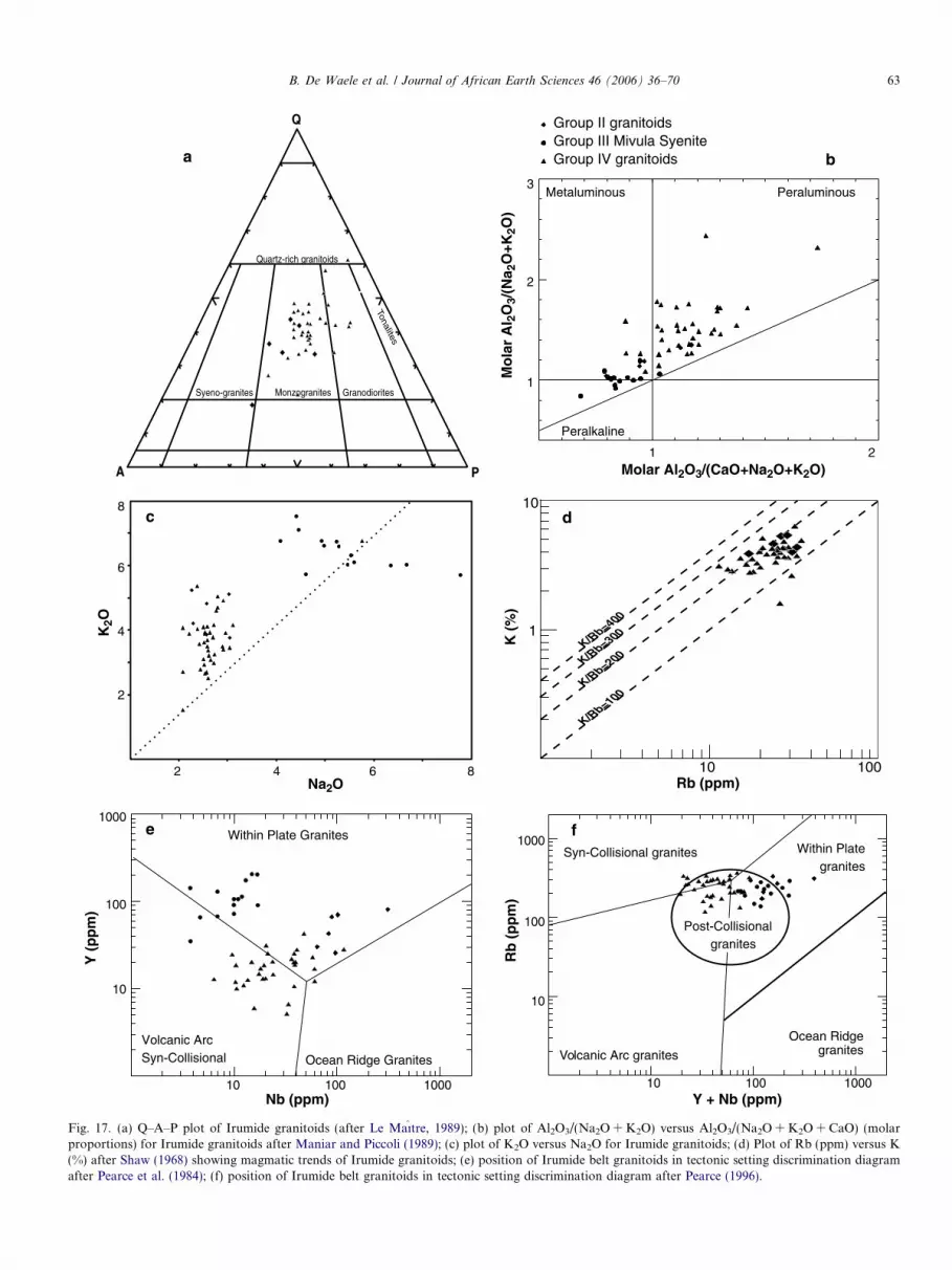
Q
PA
Syeno-granites
Quartz-rich granitoids
Monzogranites Granodiorites
Tonalites
1 2
1
2
3
Mo
lar
Al 2
O3/
(Na 2
O+K
2O)
Molar Al2O3/(CaO+Na2O+K2O)
Metaluminous Peraluminous
Peralkaline
Group II granitoidsGroup III Mivula SyeniteGroup IV granitoids
Na2O
K2O
8
6
4
2
2 6 10 100
1
10K
(%
)
K/Rb=400
K/Rb=300
K/Rb=200
K/Rb=100
10
100
10 100 1000Nb (ppm)
Y (
pp
m)
Volcanic ArcSyn-Collisional
Within Plate Granites
Ocean Ridge Granites
1000
Rb (ppm)
Rb
(p
pm
)
Y + Nb (ppm)
Within Plategranites
Syn-Collisional granites
Volcanic Arc granites
Ocean Ridgegranites
10 100 1000
10
100
1000
Post-Collisionalgranites
a b
c d
e f
4 8
Fig. 17. (a) Q–A–P plot of Irumide granitoids (after Le Maıtre, 1989); (b) plot of Al2O3/(Na2O + K2O) versus Al2O3/(Na2O + K2O + CaO) (molarproportions) for Irumide granitoids after Maniar and Piccoli (1989); (c) plot of K2O versus Na2O for Irumide granitoids; (d) Plot of Rb (ppm) versus K(%) after Shaw (1968) showing magmatic trends of Irumide granitoids; (e) position of Irumide belt granitoids in tectonic setting discrimination diagramafter Pearce et al. (1984); (f) position of Irumide belt granitoids in tectonic setting discrimination diagram after Pearce (1996).
B. De Waele et al. / Journal of African Earth Sciences 46 (2006) 36–70 63

LW10SER-6-2CND2SR12SR6SR7
10
100
1000
La Ce Pr Nd Sm Eu Gd Tb Dy Ho Er Yb Lu
Cho
ndrit
e N
orm
aliz
eda
SH 8SH 9LW 1MTG 1
10
100
1000
La Ce Pr Nd Sm Eu Gd Tb Dy Ho Er Yb Lu
Cho
ndrit
e N
orm
aliz
ed
SH 8SH 9LW 1MTG 1
c
1
10
100
1000
Prim
ordi
al M
antle
Nor
mal
ized
CsRb
BaTh
UNb
TaLa
CePb
PrSr
NdZr
HfSm
EuGd
Tb HoEr
YbY
Lu
SH 8SH 9LW 1MTG 1
d
Dy
1
10
100
1000
CsRb
BaTh
UNb
TaLa
CePb
PrSr
NdZr
HfSm
EuGd
Tb HoEr
YbY
Lu
Prim
ordi
al M
antle
Nor
mal
ized
b
LW10SER-6-2CND2SR12SR6SR7
Dy
e f
10
100
1000
CH T6FW 1
CHL 4CHL 5CHT 1CHT 2CHT 4
MUNCHL 2
La Ce Pr Nd Sm Eu Gd Tb Dy Ho Er Yb Lu
1
10
100
1000
Prim
ordi
al M
antle
Nor
mal
ized
CsRb
BaTh
UNb
TaLa
CePb
PrSr
Nd HfSm
EuGd
TbDy
HoEr
YbY
Lu
CHT 6FW 1
CHL 4CHL 5CHT 1CHT 2CHT 4
MUNCHL 2
Zr
Cho
ndrit
e N
orm
aliz
ed
KN4KN5KN7KN8
MH4MH5
CC4CC5CC8KK1KN2A
MH9CMK2
MK7ND1ND5SR5SR9
KN8B
1
10
100
1000
Prim
ordi
al M
antle
Nor
mal
ized
CsRb
BaTh
UNb
TaLa
CePb
PrSr
NdZr
HfSm
EuGd
Tb HoEr
YbY
LuDy
h
La Ce Pr Nd Sm Eu Gd Tb Dy Ho Er Yb Lu
KN8B
KN4KN5KN7KN8
MH4MH5
CC4CC5CC8KK1KN2A
MH9CMK2
MK7ND1ND5SR5SR9
10
100
1000 g
Cho
ndrit
e N
orm
aliz
ed
Group II granitoids Group II granitoids
Group IV granitoidsNE Irumide belt
Group IV granitoids
NE Irumide belt
Group IV granitoidsCentral Irumide belt
Group IV granitoidsCentral Irumide belt
Group IV granitoids
SW Irumide beltGroup IV granitoids
SW Irumide belt
Fig. 18. (a) Chondrite-normalised REE plot for Irumide belt Group II granitoids. Normalisation values after McDonough and Sun (1995). (b)Primordial-mantle-normalised spider diagram for Irumide belt Group II granitoids. Normalisation values after Sun and McDonough (1989). (c,e,g)Chondrite-normalised REE plot for Irumide belt Group IV granitoids. Normalisation values after McDonough and Sun (1995). Diagrams (c), (e) and (g)are northeastern, central and southwestern Irumide belt respectively. (d,f,h) Primordial-mantle-normalised spider diagram for Irumide belt Group IVgranitoids. Normalisation values after Sun and McDonough (1989). Diagrams (d), (f) and (h) are northeastern, central and southwestern Irumide beltrespectively.
64 B. De Waele et al. / Journal of African Earth Sciences 46 (2006) 36–70

B. De Waele et al. / Journal of African Earth Sciences 46 (2006) 36–70 65
mylonitic Mutangoshi Gneissic Granite yielded a Rb–Srwhole-rock date of 1407 ± 33 Ma (Fig. 5, Table 1, no.56, Daly, 1986). Apart from the two samples collected nearthe tectonised contact between the Chilubanama Graniteand the Mutangoshi Gneissic Granite, no samples were col-lected from what can unequivocally be ascribed to theMutangoshi Gneissic Granite. At this stage, the reportedRb–Sr age of Daly (1986) has not been confirmed by aU–Pb zircon date, but in our view could have been calcu-lated using data that possibly includes phases of the Chilu-banama Granite, and thus reflects a mixed age betweenGroup II and Group IV granitoids. An alternative inter-pretation is that the age reflects partial resetting of theRb–Sr system and can as such not be ascribed to a geolog-ical event.
Daly (1986) reported a nine-point Rb–Sr isochron of947 ± 89 Ma for the Lufila Granite and a U–Pb zirconupper intercept age of 970 ± 5 Ma for the Kaunga Granite(Fig. 9, Table 1, nos. 3 and 4). SHRIMP U–Pb zircon dat-ing by De Waele et al. (2002, 2003a,c) yielded crystallisa-tion ages for Group IV granitoids ranging from 1.05 to0.94 Ga as summarised in Table 1 and in Figs. 6–10. Nearthe junction between the Irumide and Ubendian belts, Ringet al. (1999) reported 207Pb/206Pb evaporation and TIMSzircon dates between 1.12 and 0.98 Ga (Fig. 5, Table 1,nos. 41, 43–47), but indicate that the dated granitoids occurwithin major shear zones, reactivated during the Mesopro-terozoic and then during late Pan-African, at ca. 550 Ma(Ring, 1993; Ring et al., 1999).
Major element chemical characteristics of Group IVintrusive bodies (Tables 4a–4d) indicate a substantial com-positional variation (SiO2 = 64.65–77.89%, TiO2 = 0.07–1.37%, Al2O3 = 12.14–16.17%, Fe2O3 = 0.69–5.91%,MgO = 0.11–2.48%, Na2O = 1.86–3.63% and K2O =1.89–7.59%). In the normative classification diagram, thegranitoids plot in the fields for monzogranite and granodi-orite (Fig. 17a). They are metaluminous to peraluminous(Fig. 17b), with peraluminous compositions predominating(ASI = 0.88–1.73) and have K2O/Na2O ratios greater than1 (Fig. 17c). The K/Rb ratios range from 110 to 266 andthe data define a magmatic trend consistent with unalteredgranitoids (Fig. 17d). The trace element concentrations arevariable in Group IV granitoids (see Tables 4a–4d). In thediscrimination diagrams of Pearce et al. (1984) and Pearce(1996), these granitoids plot in the fields for continental-collision-related syn- to post-orogenic granitoids, arc gran-ites and within-plate granites (Fig. 17e and f). The domi-nance of peraluminous compositions and theemplacement during the paroxysm of D2/M2 or duringthe late- to post-kinematic stage of the Irumide orogenyindicate that these are not arc or anorogenic granitoids.They represent felsic melts originating from partial meltingof the crust during the Irumide orogeny. The overlapbetween the age of these granitoids and the Barrovian-typemetamorphism support this interpretation.
The REE abundances are 101–849 times chondrite(Fig. 18c, e and g). The REE patterns display a negative
Eu anomaly (Eu/Eu* = 0.15–0.88) and are characterisedby LaN/YbN values in the range 9–74. The LREE displaya fractionated pattern (LaN/SmN = 2.8–6.6), while theHREE are marked by sub-flat patterns with GdN/YbN
between 1.5 and 9.0. The primordial-mantle-normalisedpatterns of these granitoids show negative anomalies forBa, Nb–Ta, Ce, Sr, Eu and Zr–Hf (Fig. 18d, f and h).The geochemical data above are consistent with derivationfrom crustal partial melting in a convergent setting.
6. Regional implications and tectonic models
6.1. Age of pre-Irumide basement
The dominant pre-Irumide units exposed in the Irumidebelt are �2.05–1.85 Ga igneous rocks and closely related�1.85 Ga Muva Supergroup metasedimentary rocks.These units represent the main component of the Bangwe-ulu block, while Neoarchaean rocks represent a smallercomponent and are exposed at two localities in southeast-ern Zambia. The Archaean to PalaeoproterozoicBangweulu block crust has been intruded by a suite ofcrust-originating granitoids between 1.65 and 1.55 Ga.Available data do not indicate a metamorphic event asso-ciated with the intrusion of these granitoids, and morework is needed to elucidate their significance in the tectonicevolution of central Africa.
6.2. Age of the Muva Supergroup
Previous workers (Daly and Unrug, 1982; Unrug, 1984)assumed that the Muva Supergroup is Mesoproterozoic inage. SHRIMP U–Pb zircon geochronological datareviewed in this paper (Table 1, Figs. 5 and 13) showinstead that the Muva Supergroup was deposited betweenca. 1.85 and 1.65 Ga. This is indicated by: (1) the absenceof detrital zircon younger than �1.85 Ga (Rainaud et al.,2003; De Waele and Fitzsimons, submitted for publication)and (2) �1.88–1.85 Ga rhyolites interstratified within theMuva succession (De Waele and Fitzsimons, submittedfor publication). These data indicate that deposition ofthe Muva Supergroup overlaps with emplacement of late-Ubendian potassic calc-alkaline volcanic and plutonicrocks in the Bangweulu block. Furthermore, the geochro-nological data support the coeval deposition of ManshyaRiver Group quartzites and Mporokoso Group sedimen-tary rocks. As such, the Manshya River, Kanona andMporokoso Group are related to the evolution of theBangweulu block, and the adjacent PalaeoproterozoicUbendian orogenic system, as previously suggested byAndersen and Unrug (1984), Kabengele et al. (1991) andKapenda et al. (1998).
Tembo and Porada (submitted for publication) reviewedthe distribution of the Muva quartzites and possible corre-latives in Zambia and showed that they possibly extendoutside the Irumide belt, e.g. within the Zambezi belt. Theyalso suggested that these quartzites might be lateral corre-

66 B. De Waele et al. / Journal of African Earth Sciences 46 (2006) 36–70
latives of the abundant quartzites described in the Kibaranbelt in Katanga, DRC. Hanson (2003) suggested, on thisground, that the southeast Kibaran (Katanga, DRC) andMuva (Zambia) sedimentary basins were originally contin-uous. Detrital provenance study on quartzites from theKibaride belt in Katanga record 1.38 Ga detrital zircons(Kokonyangi et al., in press) and the same apply for partof the succession in the northern Kibaran belt (Cuttenet al., 2004), placing a maximum age on these successions.The only sedimentary package within the Irumide belt thatcould possibly relate to these Mesoproterozoic sequences incentral Africa is the Kasama Formation on the Bangweulublock, which contains detrital zircons as young as 1.43 Ga(De Waele and Fitzsimons, submitted for publication).
6.3. Timing of Irumide tectonism
Peak Irumide conditions have been constrained at1021 ± 16 and 1004 ± 16 Ma through low Th/U zirconovergrowths in high-grade granitoids and gneisses withinthe Irumide belt s.s. (De Waele et al., 2003c, De Waele,2005). Previous estimates in the southeastern parts of theIrumide belt place the timing of peak metamorphic condi-tions at 1046 ± 3 (Schenk and Appel, 2002) Ma and1043 ± 19 Ma (Cox et al., 2002). These dates indicate a dia-chronous metamorphic front across strike, consistent withcompressional arc tectonics along a convergent margin.
6.4. Irumide basin
The first modern tectonic interpretation of the Irumidebelt is that of Daly (1986) who proposed that the beltformed during closure of a Mesoproterozoic marine basinwithin which the Muva Supergroup had accumulated.However, the data in this paper show that there is no evi-dence for an extensional sedimentary basin (equivalent tothe first-stage of the Wilson-cycle) that opened after thePalaeoproterozoic Ubendian orogeny and was filled bysedimentary sequences that underwent orogenesis for thefirst time during the late Mesoproterozoic Irumide orog-eny. In fact, the Manshya River/Kanona Group successionof the Irumide belt represents the deformed Ubendianmolasse sequence, while the Mporokoso Group on theBangweulu block foreland to the Irumide belt representsthe undeformed Ubendian molasses. To date, extensiveMesoproterozoic successions deposited along the southernmargin of the Bangweulu block are yet to be identified. Inour view, the exposed part of the Irumide belt lies outsidethe main site of closure of a Mesoproterozoic ocean to thesoutheast. Mesoproterozoic oceanic crust has been docu-mented to the southeast of the Irumide belt in the 1.4 GaChewore complex in Zimbabwe (Johnson, 1999), providingevidence of an oceanic realm to the southeast as far back as1.4 Ga. A series of juvenile magmatic arcs have been recog-nised in southern Malawi (1.04–1.00 Ga, Kroner et al.,1999), northwestern Mozambique (1.05–1.01 Ga, Kroneret al., 1997, 2000; Manhica et al., 2001), northern Zimba-
bwe (1.10–1.05 Ga, Johnson and Oliver, 2004) and centralZambia (�1.10 Ga, Hanson, 1999; Katongo et al., 2004)and are interpreted to have been accreted to the south-ern margin of the Bangweulu block during Irumidetectonism.
6.5. ‘‘Pop-up’’ model
The double vergence ‘‘pop-up’’ model proposed by Daly(1986) in the southwestern Irumide, was based on the rec-ognition of upright structures and amphibolite facies rocksmarking the core of a doubly-vergent tectonic complex.However, lithologies assigned by Daly (1986) to a Palaeo-proterozoic culmination in that pop-up structure have beenshown to be late Irumide in age. De Waele and Mapani(2002) considered the southeast-verging thrusts to repre-sent back-thrusts within the main northwest-directedthick-skinned Irumide thrusts, possibly formed in responseto basement topography. Although the presence of abun-dant Irumide-age granitoids rather than Palaeoproterozoicbasement does not invalidate the ‘‘pop-up’’ model, the tec-tonic significance of the structure is greatly reduced.
6.6. Tectonic models
6.6.1. Geochemical indicators
The peraluminous Group IV Irumide granitoids displayrelatively high SiO2 contents, with Aluminium SaturationIndex values indicating a predominance of strongly peralu-minous compositions. The geochemical characteristics ofthese granitoids could suggest the involvement of a broadspectrum of source lithologies during their genesis, i.e. theycould have originated from partial melting of metamor-phosed igneous and sedimentary rocks. The large volumeof ca. 1.05–1.02 Ga granitoids within the Irumide belt, alldisplaying similar geochemical traits marked by enrich-ment in LILE and depletion in HFS elements is consistentwith their generation from extensive crustal melting. Mag-matic underplating is commonly described as an importantprocess of crustal growth in a wide variety of setting,including accretionary and collisional orogens (Mooresand Twiss, 1995) and could have provided the heat-sourcerequired for large-scale crustal anatexis. The structuraldata show that the peraluminous Group IV granitoidsare syn-to late-kinematic compared to the climax of theIrumide orogeny, and SHRIMP U–Pb geochronologicaldata (Table 1) indicate that they are broadly coeval witha metamorphic event dated at �1021–1012 Ma. The geo-chemical evidence to date supports the notion that the Iru-mide belt s.s. represents the intensely reworked margin ofthe Palaeoproterozoic Bangweulu block.
6.6.2. Metamorphic indicators
The regional metamorphic grade in the Irumide belt is ofmedium pressure/medium temperature Barrovian type,which is more consistent with an accretionary setting thena continent–continent collision. Although no quantitative

B. De Waele et al. / Journal of African Earth Sciences 46 (2006) 36–70 67
data are available, preliminary P–T–t models suggest aclockwise metamorphic P–T–t path (Mapani, 1999) thatis here linked to the major shortening event recorded bynorthwest-vergent thrusts. A younger anti-clockwise P–T–t path recognised locally in the Irumide belt could markpost-orogenic crustal extension but there is no structuralevidence to support this interpretation. In our interpreta-tion, the central high-grade part of the belt, previouslyinferred to represent a ‘‘pop-up’’ structure (Daly, 1986)represents a major zone of syn- to late-kinematic pluto-nism, creating a high thermal gradient in the crust causingan anti-clockwise P–T–t path. More geochemical and pos-sibly isotopic data are required in order to more reliablyconstrain the origin of the Irumide igneous rocks. Peakmetamorphic constraints for the Irumide belt are 30 M.y.younger than those recorded in the southeastern extent ofthe belt. This diachroneity is thought to reflect compres-sional continental-margin arc tectonics, in which continen-tal and/or oceanic arcs are accreted to the southern marginof the Bangweulu block during Irumide tectonism.
6.7. Regional correlations
Shackleton (1973) and Hanson et al. (1988) suggestedthat the Irumide belt and the Choma–Kalomo block weretwo segments of the same belt cross-cut by the Neoprotero-zoic Zambezi belt. Kampunzu et al. (1991, 1993, 2000)showed that igneous rocks exposed in the adjacent Dama-ran-Katangan segments of the Pan African orogenic sys-tem represent continental rift and Red-Sea-type maficrocks, supporting limited development of Neoproterozoicseafloor along this trend, and therefore allowing thepossibility of a linkage between the Irumide belt andChoma–Kalomo block. However, based on the presenceof yoderite-bearing whiteschists in the Zambezi belt,Johnson and Oliver (2000) argue for the closure of a majorNeoproterozoic ocean during convergence between theCongo and Kalahari cratons. John et al. (2003, 2004) con-sider the eclogites within the Zambezi belt and the LufilianArc to represent relict oceanic crust. The eclogites recordlow geothermal gradients during metamorphism (�8 �C/km) and have been subducted to depths of �90 km. Johnet al. (2001, 2003, 2004) take this to indicate the presenceof a mature ocean basin that separated the Congo and Kal-ahari cratons prior to Pan African orogenesis. This inter-pretation would make it unlikely that the Choma–Kalomo block would be the southwestern extension ofthe Irumide belt. Geological and geochronological datapresented in this paper show that the timing of magmaticevents in the Irumide belt differs substantially from thatin the Choma–Kalomo block. The critical differencesbetween these two terranes are the following: (a) Palaeo-proterozoic rocks are widespread and form the bulk ofthe crustal section affected by late Mesoproterozoic short-ening in the Irumide belt. In contrast, Palaeoproterozoicrocks are unknown in the Choma–Kalomo block (Hansonet al., 1988); (b) granitoids emplaced between 1.4 and
1.2 Ga form large parts of the Choma–Kalomo block(Hanson et al., 1988) and their geochemical features sug-gest that they represent peraluminous felsic melts possiblyoriginating from crustal anatexis (Bulambo et al., 2004).In contrast, peraluminous granitoids in that age rangeare unknown in the Irumide belt (De Waele et al.,2003c). A minor nepheline–sodalite syenite and a biotitegranite gneiss dated by Tembo (1986) and Vrana et al.(2004) and a suite of A-type granitoids in northern Zambiaoutside the main Irumide belt (Ring et al., 1999) are time-correlatives of granitoids exposed in the Choma–Kalomoblock and in the Kibaride belt. Their petrological charac-teristics however suggest emplacement in an anorogenicsetting and thus unrelated to the evolution of the younger(�1.05–0.95 Ga) Irumide belt. Although these data are notconsistent with a direct linkage between the Choma–Kalomo block and the Irumide belt, and lend support tothe interpretation of Johnson and Oliver (2000), John(2001) and John et al. (2003, 2004), they do not providedirect proof for the development of a large Neoproterozoicocean basin between the Congo and Kalahari cratons. Elu-cidating the complex Neoproterozoic evolution of this partof Africa requires further research.
Acknowledgements
This work has been made possible through the financialand logistical support from the Geology Department at theUniversity of Zambia, the Australian Research Council(ARC) through the Tectonic Special Research Centre, anda Curtin University International Postgraduate ResearchScholarship (IPRS) awarded to B.D.W. We acknowledgethe support of Watling, Pritchard and Fjastad for the geo-chemical analyses conducted at the School of AppliedChemistry, Curtin University. A.B.K. acknowledges thefinancial support of the University of Botswana (1995–2001), the University of Lubumbashi (1976–1995) and theIGCP 440 that allowed him to reach his current understand-ing of the Bangweulu block in DRC and Zambia. Lubala,Kapenda, Kabengele and Tshimanga are acknowledgedfor their collaboration with A.B.K. during the study ofthe Congolese section of the Bangweulu block. This paperis TSRC Publication 257 and is a contribution to the Inter-national Geological Correlation Projects 418 and 440.
References
Ackermann, E.H., 1936. Das problem der Mkushi-Gneise am NW-randder Rhodesischen masse. Geologische Rundschau 27, 81–87.
Ackermann, E.H., 1950. Ein neuer faltengurtel in Nordrhodesien undseine tectonische stellung im Afrikanishen grundgebirge. GeologischeRundschau 38, 24–39.
Ackermann, E.H., 1960. Strukturen im untergrund eines intrakratonis-chen doppelorogens (Irumiden Nordrhodesien). Geologische Runds-chau 50, 538–553.
Ackermann, E.H., Forster, A., 1960. Grundzuge der stratigraphie undstruktur des Irumide Orogen. In: 21st International GeologicalCongress, pp. 182–192.

68 B. De Waele et al. / Journal of African Earth Sciences 46 (2006) 36–70
Agar, R.A., Ray, A.K., 1983. The geological map of the Petauke area(1:250,000). Geological Survey of Zambia, Lusaka.
Andersen, L.S., Unrug, R., 1984. Geodynamic evolution of the Bangweulublock, northern Zambia. Precambrian Research 25, 187–212.
Andrews-Speed, C.P., 1986. Gold-bearing fluvial and associated tidalmarine sediments of Proterozoic age in the Mporokoso basin, northernZambia. Sedimentary Geology 48, 193–222.
Andrews-Speed, C.P., 1989. The Mid-Proterozoic Mporokoso basin,northern Zambia: sequence stratigraphy, tectonic setting and potentialfor gold and uranium mineralisation. Precambrian Research 44, 1–17.
Andrews-Speed, C.P., Unrug, R., 1982. Gold in the sedimentary cover ofthe Bangweulu block, northern Zambia. Gold 82, 221–237.
Ayres, H.R., 1974. The geology of the Shiwa N’Gandu area; explanationof degree sheet 1131, NE quarter. Report Geological Survey Zambia64.
Barr, M.W.C., Drysdall, A.R., 1972. The geology of the Sasare area;explanation of degree sheet 1131, SW quarter. Report GeologicalSurvey of Zambia 30.
Brewer, M.S., Haslam, H.W., Darbyshire, P.F.P., Davis, A.E., 1979. Rb–Sr age determinations in the Bangweulu block. Luapula Province,Zambia, Institute of Geological Sciences London 79-5, 11p.
Bulambo, M., De Waele, B., Kampunzu, A.B., Tembo, F., 2004.SHRIMP U–Pb geochronology of the Choma–Kalomo block (Zam-bia) and geological implications. In: 20th Colloquium of AfricanGeology, Orleans, France.
Carruthers, H., 2000. The geological map of the Chin’gombe area.Geological Survey Department of Zambia, Lusaka.
Chisela, S., 2000. The geological map of the Kakulu area. GeologicalSurvey Department of Zambia, Lusaka.
Cordiner, R.J., 1977. The geology of the Chitambo mission area;explanation of degree sheet 1230, SE quarter. Report GeologicalSurvey Department of Zambia 54.
Cordiner, R.J., 2000. The geological map of the Kanona area. TheGeological Survey Department of Zambia, Lusaka.
Cox, R.A., Rivers, T., Mapani, B., Tembo, D., De Waele, B., 2002. NewU–Pb data for the Irumide belt: LAM–ICP–MS results for LuangwaTerrane. In: Geological Society of Namibia (Ed.), 11th IAGODQuadrennial Symposium and Geocongress, Windhoek, Namibia, 3p.
Cutten, H., De Waele, B., Fernandez-Alonso, M., Tack, L., 2004. Ageconstraints for basin evolution and sedimentation in the ‘‘NortheasternKibaran Belt’’. In: 20th Colloquium of African Geology, Orleans,France.
Cvetcovic, D., 1973. The geology of the Mita hills area; explanation ofdegree sheet 1429, NW quarter. Report Geological Survey Departmentof Zambia 34.
Daly, M.C., 1986. The Tectonic and Thermal Evolution of the IrumideBelt, Zambia. PhD Thesis, University of Leeds, 326p.
Daly, M.C., 1994a. The geological map of the Chinsali area (1:100,000).Geological Survey Department of Zambia, Lusaka.
Daly, M.C., 1994b. The geological map of the Isoka area (1:100,000).Geological Survey Department of Zambia, Lusaka.
Daly, M.C., 1994c. The geological map of the Mulilansolo Mission area(1:100,000). Geological Survey Department of Zambia, Lusaka.
Daly, M.C., 1995. The geology of Mulilansolo Mission and Isoka areas;explanation of degree sheet 1032, NE and NW quarter. ReportGeological Survey Department of Zambia 84.
Daly, M.C., Unrug, R., 1982. The Muva Supergroup, northern Zambia.Transactions of the Geological Society of South Africa 85, 155–165.
De Waele, B., 2005. The Proterozoic geological history of the Irumide belt,Zambia. PhD Thesis, Curtin University of Technology, Perth, 468 pp.
De Waele, B., Fitzsimons, I.C.W., submitted for publication. The natureand timing of Palaeoproterozoic sedimentation around the Bangweulublock of northern Zambia. Journal of the Geological Society of London.
De Waele, B., Mapani, B., 2002. Geology and correlation of the centralIrumide belt. Journal of African Earth Sciences 35 (3), 385–397.
De Waele, B., Wingate, M.T.D., Mapani, B., 2002. Geochronologicalconstraints on granitoid magmatism and deformation in the south-western Irumide belt, Zambia. In: Geological Survey of Namibia (Ed.),
11th IAGOD Quadrennial Symposium and Geocongress, Windhoek,Namibia, p. 3.
De Waele, B., Fitzsimons, I.C.W., Wingate, M.T.D., Mapani, B., 2003a.The tectonothermal history of the Irumide belt of Zambia. Regionalsignificance of new geochronological constraints. In: Li, H., Zhang, S.(Eds.), Assembly and Breakup of Rodinia, South China FieldSymposium, Chengdu Institute of Geology and Mineral Resources,China Geological Survey, Hangzhou, China, pp. 16–19.
De Waele, B., Nemchin, A.A., Kampunzu, A.B., 2003b. The Bangweulublock of northern Zambia: where is the pre-Ubendian crust? In: Li, H.,Zhang, S. (Eds.), Assembly and Breakup of Rodinia, South ChinaField Symposium, Chengdu Institute of Geology and MineralResources, China Geological Survey, Hangzhou, China, pp. 19–21.
De Waele, B., Wingate, M.T.D., Mapani, B., Fitzsimons, I.C.W., 2003c.Untying the Kibaran knot: a reassessment of Mesoproterozoiccorrelations in southern Africa based on SHRIMP U–Pb data fromthe Irumide belt. Geology 31 (6), 509–512.
De Waele, B., Liegeois, J.P., Nemchin, A.A., Tembo, F., 2005. Isotopic andgeochemical evidence of Proterozoic episodic crustal reworking withinthe Irumide Belt of south-central Africa, the southern metacratonicboundary of an Archaean Bangweulu Craton. Precambrian Research.
Dodson, M.H., Cavanagh, B.J., Thatcher, E.C., Aftalion, M., 1975. Agelimits for the Ubendian metamorphic episode in northern Malawi.Geological Magazine 112, 403–410.
Drysdall, A.R., Johnson, R.L., Moore, T.A., Thieme, J.G., 1972. Outlineof the geology of Zambia. Geologie en Mijnbouw 51, 265–276.
Fitches, W.R., 1968. Structural and Stratigraphic Relations in thePrecambrian Rocks of the Mafingi Hills Area of Northern Malawiand Zambia. PhD Thesis, University of Leeds.
Fitches, W.R., 1971. Sedimentation and tectonics at the northern end ofthe Irumide orogenic belt, northern Malawi and Zambia. GeologischeRundschau 59, 444–458.
Forster, A., 1965. Der kristallin sockel im ostlichen Nordrhodesien undsein verband mit anderen baueinheiten zentral- und Ostafrikas.Geotektonische Forschungen 20 (I–II), 115.
Hanson, R.E., 1999. The Mpande Gneiss. In: De Waele, B., Tembo, F.,Key, R.M. (Eds.), Fieldtrip Guide: The Zambian Irumide belt.Geological Society of Zambia, Lusaka.
Hanson, R.E., 2003. Proterozoic geochronology and tectonic evolution ofsouthern Africa. In: Yoshida, M., Windley, B.F., Dasgupta, S. (Eds.),Proterozoic East Gondwana: Supercontinent Assembly and Breakup.Geological Society of London, pp. 427–463.
Hanson, R.E., Wilson, T.J., Brueckner, H.K., Onstott, T.C., Wardlaw,M.S., Johns, C.C., Hardcastle, K.C., 1988. Reconnaissance geochro-nology, tectonothermal evolution, and regional significance of themiddle Proterozoic Choma–Kalomo block, southern Zambia. Pre-cambrian Research 42, 39–61.
Haslam, H.W., Rundle, C.C., Brewer, M.S., 1986. Rb–Sr studies ofmetamorphic and igneous events in eastern Zambia. Journal ofAfrican Earth Sciences 5 (5), 447–453.
John, T., 2001. Subduction and Continental Collision in the Lufilian Arc–Zambezi Belt Orogen: A Petrological, Geochemical, and Geochrono-logical Study of Eclogites and Whiteschists (Zambia). PhD Thesis,Kiel, 78 p.
John, T., Schenk, V., Haase, K., Scherer, E., Tembo, F., 2003. Evidencefor a Neoproterozoic ocean in south-central Africa from mid-oceanic-ridge-type geochemical signatures and pressure-temperature estimatesof Zambian eclogites. Geology 31 (3), 243–246.
John, T., Schenk, V., Mezger, K., Tembo, F., 2004. Timing and PTevolution of whiteschist metamorphism in the Lufilian arc–Zambezibelt Orogen (Zambia): implications for the assembly of Gondwana.Journal of Geology 112, 71–90.
Johns, C.C., Liyungu, K., Mabuku, S., Mwale, G., Sakungo, F., Tembo,D., Vallance, G., Barr, M.W.C., 1989. The stratigraphic and structuralframework of eastern Zambia: results of a geotraverse. Journal ofAfrican Earth Sciences 9, 123–136.
Johnson, S., 1999. A Kibaran-aged marginal basin and island-arc complexin northern Zimbabwe. In: De Waele, B., Tembo, F., Key, R.M.

B. De Waele et al. / Journal of African Earth Sciences 46 (2006) 36–70 69
(Eds.), Abstracts Volume IGCP 418/419. Geological Society ofZambia, Lusaka, p. 6.
Johnson, S.P., Oliver, G.J.H., 2000. Mesoproterozoic oceanic subduction,island-arc formation and the initiation of back-arc spreading in theKibaran belt of central, southern Africa: evidence from the ophioliteterrane, Chewore inliers, northern Zimbabwe. Precambrian Research103, 125–146.
Johnson, S.P., Oliver, G.J.H., 2004. Tectonothermal history of theKarouera arc, northern Zimbabwe. Precambrian Research 130, 71–97.
Johnson, S.P., Rivers, T., De Waele, B., 2005. A review of theMesoproterozoic to early Palaeozoic magmatic and tectonothermalhistory of south-central Africa: implications for Rodinia and Gondw-ana. Journal of the Geological Society of London 162, 433–450.
Kabengele, M., Lubala, R.T., Cabanis, B., 1991. Caracterisation petro-logiques et geochimique du magmatisme ubendien du secteur de Pepa-Lubumba, sur le plateau des Marungu (Nord-Est du Shaba, Zaire).Signification geodynamique dans l’evolution de la chaine ubendienne.Journal of African Earth Sciences 13 (2), 243–265.
Kampunzu, A.B., Kapenda, D., Manteka, B., 1991. Basic magmatism andgeotectonic evolution of the Pan African belt in central Africa:evidence from the Katangan and west Congolian segments. Tectono-physics 190, 363–371.
Kampunzu, A.B., Kanika, M., Kapenda, D., Tshimanga, K., 1993.Geochemistry and geotectonic setting of late Proterozoic Katanganbasic rocks from Kibambale in Central Shaba (Zaire). GeologischeRundschau 82, 619–630.
Kampunzu, A.B., Tembo, F., Matheis, G., Kapenda, D., Huntsman-Mapila, P., 2000. Geochemistry and tectonic setting of mafic igneousunits in the Neoproterozoic Katangan Basin, central Africa; implica-tions for Rodinia break-up. Gondwana Research 3, 125–153.
Kapenda, D., Kampunzu, A.B., Canabis, B., Namegabe, M., Tshimanga,K., 1998. Petrology and geochemistry of post-kinematic mafic rocksfrom the Palaeoproterozoic Ubendian belt, NE Katanga (DRC).Geologische Rundschau 87, 345–362.
Katongo, C., Koller, F., Klotzli, U., Koeberl, C., Tembo, F., De Waele,B., 2004. Petrography, geochemistry and geochronology of keygranitoid rocks in the Neoproterozoic–Paleozoic Lufilian–Zambezibelt, Zambia: implications for the tectonic setting and regionalcorrelation. Journal of African Earth Sciences 40 (5), 219–244.
Kerr, C.D., 1975. The geology of the Fiwila mission area; explanation ofdegree sheet 1329, SE quarter. Report Geological Survey Departmentof Zambia 68.
Key, R.M., Liyungu, A.K., Njamu, F.M., Somwe, V., Banda, J., Mosley,P.N., Armstrong, R.A., 2001. The western arm of the Lufilian arc inNW Zambia and its potential for copper mineralisation. Journal ofAfrican Earth Sciences 33, 503–528.
Kinnaird, J.A., Bowden, P., 1991. Magmatism and mineralisationassociated with Phanerozoic anorogenic plutonic complexes of theAfrican Plate. In: Kampunzu, A.B., Lubala, R.T. (Eds.), Magmatismin Extensional Structural Settings: The Phanerozoic African Plate.Springer-Verlag, Berlin, pp. 410–485.
Klerkx, J., Theunissen, K., Delvaux, D., 1998. Persistent fault controlledbasin formation since the Proterozoic along the western branch of theEast African Rift. Journal of African Earth Sciences 26, 347–361.
Kokonyangi, J., Kampunzu, A.B., Armstrong, R., Ngulube, D.A.,Yoshida, M., Okudaira, T., in press. The Mesoproterozoic Kibaridebelt (Katanga, SE D.R. Congo). Journal of African Earth Sciences,doi:10.1016/j.jafrearsci.2006.01.017.
Kroner, A., Sacchi, R., Jaeckel, P., Costa, M., 1997. Kibaran magmatismand Pan-African granulite metamorphism in northern Mozambique:single zircon ages and regional implications. Journal of African EarthSciences 25 (3), 467–484.
Kroner, A., Windley, B.F., Jaeckel, P., Collins, A.S., Brewer, T.S.,Nemchin, A., Razakamanana, T., 1999. New zircon ages forPrecambrian granites, gneisses and granulites from central andsouthern Madagascar: significance for correlations in East Gondwana.Gondwana Research 2 (3), 351–352.
Kroner, A., Dirks, P.H.G.M., Jamal, D.L., 2000. Archaean, Kibaran andPan-African zircon ages for granitoid rocks in northwestern Mozam-bique, GeoLuanda, Luanda, Angola.
Le Maıtre, R.W., 1989. A classification of igneous rocks and glossary ofterms: recommendations of the International Union of GeologicalSciences subcommission on the systematics of igneous rocks. Black-well, Oxford, 193 pp..
Liyungu, K., Vinyu, M., 1996. Constraints on the timing of the high-gradeLutembwe quartz-feldspathic granulite, charnockitic enderbite and therelationship to the Chipata granite in the Mozambique belt. In:Kamona, F., Tembo, F., Mapani, B.S.E. (Eds.), IGCP 363: Palaeo-proterozoic of sub-Equatorial Africa. Geological Society of Zambia,Lusaka, p. 19.
Lucacik, E., 1998. The geology of the Ilondola Mission area; explanationof degree sheet 1031, SE quarter. Report Geological Survey Depart-ment of Zambia 95.
Maniar, P.D., Piccoli, P.M., 1989. Tectonic discrimination of granitoids.Geological Society of America Bulletin 101, 635–643.
Manhica, A.D.S.T., Grantham, G.H., Armstrong, R.A., Guise, P.G.,Kruger, F.J., 2001. Polyphase deformation and metamorphism atthe Kalahari craton-Mozambique belt boundary. In: Miller, J.A.,Holdsworth, R.A., Buick, I.S., Hand, M. (Eds.), ContinentalReactivation and Reworking. Geological Society of London, pp.303–322.
Mapani, B., 1999. Tectonic and metamorphic evolution of the Serenje andadjoining areas. In: De Waele, B., Tembo, F., Key, R.M. (Eds.),Abstracts Volume IGCP 418/419. Geological Society of Zambia,Lusaka, p. 16.
Mapani, B.S.E., Moore, T.A., 1995. The geology of the Serenje area;explanation of degree sheet 1330, NW quarter. Report GeologicalSurvey Department of Zambia 51.
Mapani, B.S.E., Rivers, T., Tembo, F., Katongo, C., 2001. Terranemapping in the eastern Irumide and Mozambique belts: implicationsfor the assembly and dispersal of Rodinia. In: McCourt, S. (Ed.),IGCP 418 4th fieldmeeting. University of Durban-Westville, Durban,South Africa.
Marten, B.E., 1968. The geology of the Chalabesa Mission area;explanation of degree sheet 1131, NW quarter. Report GeologicalSurvey Department of Zambia 23.
McDonough, W.F., Sun, S.-S., 1995. The composion of the Earth.Chemical Geology 120, 228.
Moore, T.A., 1967. The geology of the Ndola and Bwana Mkubwa areas;explanation of degree sheets 1228, part of SE quarter, and 1328, partof NE quarter. Report Geological Survey Department of Zambia 20.
Moores, E.M., Twiss, R.J., 1995. Tectonics. W.H. Freeman andCompany, New York, 415p.
Mosley, P.N., 1979. The geology of the Mtofwe area; explanation ofdegree sheet 1132, SW quarter. Report Geological Survey Departmentof Zambia 82.
Mosley, P.N., Marten, B.S., 1979. The geology of the Katibunga missionarea; explanation of degree sheet 1131, SE quarter. Report GeologicalSurvey Department of Zambia 81.
Namateba, C., 1994. The geology of the Mafinga Hills area; explanationof degree sheet 0933, SW quarter. Report Geological Survey Depart-ment of Zambia 93.
Newton, A.R., 1959. On the syenite of Mivula Hill, easternprovince. Records of the Geological Survey of Zambia 1957, 14–17.
Ngoyi, K., Liegeois, J.-P., Demaiffe, D., Dumont, P., 1991. Age tardi-ubendien (Proterozoıque inferieur) des domes granitiques de l’arccuprifere zaıro-zambien. Comptes Rendu de l’Academie de Sciences313 (II), 83–89.
Page, T.C., 1973. The geology of the Chilonga Mission area; explanationof degree sheet 1231, NW quarter. Report Geological Survey Depart-ment of Zambia 56.
Pearce, J.A., 1996. Sources and settings of granitic rocks. Episodes 19,120–125.

70 B. De Waele et al. / Journal of African Earth Sciences 46 (2006) 36–70
Pearce, J.A., Harris, N.B.W., Tindle, A.G., 1984. Trace element discrim-ination diagrams for the tectonic interpretation of granitic rocks.Journal of Petrology 25, 956–983.
Phillips, K.A., 1960. The geology of the Sinda area; explanation of degreesheet 1431, NE quarter. Report Geological Survey of Zambia 9.
Phillips, K.A., 1964. The geology of the Lusandwa River area; explanationof degree sheet 1331, SE quarter. Report Geological Survey of Zambia13.
Phillips, K.A., 1965. The geology of the Petauke – Mwanjawantu area;explanation of degree sheet 1431, NW and part of SW quarters.Report Geological Survey of Zambia 15.
Pitcher, W.S., 1997. The Nature and Origin of Granite. Chapman & Hall,London, 408p.
Rainaud, C., Master, S., Armstrong, R.A., Robb, L.J., 2003. A crypticMesoarchaean terrane in the basement to the central African Copper-belt. Journal of the Geological Society of London 160, 11–14.
Rainaud, C.L., Armstrong, R.A., Master, S., Robb, L.J., Mumba,P.A.C.C., 2002. Contributions to the geology and mineralisation ofthe central African Copperbelt: I. Nature and geochronology of thepre-Katangan basement. In: Geological Survey of Namibia (Ed.), 11thIAGOD Quadrennial Symposium and Geocongress, Windhoek,Namibia, p. 5.
Rainaud, C., Master, S., Armstrong, R.A., Robb, L.J., 2005. Geochro-nology and nature of the Palaeoproterozoic basement in the CentralAfrican Copperbelt (Zambia and the Democratic Republic of Congo),with regional implications. Journal of African Earth Sciences 42, 1–31.
Ramsay, C.R., Ridgway, J., 1977. Metamorphic patterns in Zambia andtheir bearing on problems of Zambian tectonic history. PrecambrianResearch 4, 321–337.
Reichwalder, P., Brandon, A., 1992. The geological map of the LuanoValley area. Geological Survey Department of Zambia, Lusaka.
Ridgway, J., Ramsay, C.R., 1986. A provisional metamorphic map ofZambia – explanatory notes. Journal of African Earth Sciences 5 (5),441–446.
Ring, U., 1993. Aspects of the kinematic history and mechanisms ofsuperposition of the Proterozoic mobile belts of eastern central Africa(northern Malawi and southern Tanzania). Precambrian Research 62,207–226.
Ring, U., Kroner, A., Toulkeredis, T., 1997. Palaeoproterozoic granulite-facies metamorphism and granitoid intrusions in the Ubendian–Usagaran Orogen of northern Malawi, east-central Africa. Precam-brian Research 85, 27–51.
Ring, U., Kroner, A., Layer, P., Buchwaldt, R., Toulkeredis, T., 1999.Deformed A-type granites in northern Malawi, east-central Africa:pre- or syntectonic. Journal of the Geological Society of London 156,695–714.
Schandelmeier, H., 1980. Regionale gliederung des Prakambriums undaspekte der krustentwicklung um Mambwe/nordost-Zambia. PhDThesis, Technical University of Berlin, Berlin, 134 p.
Schandelmeier, H., 1981. The Precambrian of NE Zambia in relation tothe dated Kate, Mambwe and Luchewe intrusives. GeologischeRundschau 70 (2), 956–971.
Schandelmeier, H., 1983. The geochronology of post-Ubendian granitoidsand dolerites from the Mambwe area, northern Province, Zambia.Report Institute of Geological Sciences 83 (1), 40–46.
Schenk, V., Appel, P., 2001. Anti-clockwise P–T path during ultrahigh-temperature (UHT) metamorphism at ca. 1050 Ma in the Irumide beltof eastern Zambia. Berichte der Deutschen Mineralogischen Gesell-schaft, Beihefte zum European Journal of Mineralogy 13, 161.
Schenk, V., Appel, P., 2002. UHT-metamorphism in the Irumide belt ofZambia: an anti-clockwise P–T path and concordant monazite age at1.05 Ga. In: Ennih, N., Abdelsalam, M.G. (Eds.), 19th Colloquium ofAfrican Geology, El Jadida, Morocco, p. 165.
Shackleton, R.M., 1973. Correlation of structures across Precambrianorogenic belts in Africa. In: Tarling, D.H., Runcorn, S.K. (Eds.),Implications of Continental Drift to the Earth Sciences. Academicpress, London, pp. 1091–1095.
Shaw, D.M., 1968. A review of K–Rb fractionation trends by covarianceanalysis. Geochimica et Cosmochimica Acta 32, 573–601.
Smith, A.G., 1966. The geology of the Kapiri Mposhi area; explanation ofdegree sheet 1328, SE quarter. Report Geological Survey Departmentof Zambia 18.
Smith, A.G., Kerr, C.D., 1975. The geology of the Ndabala area;explanation of degree sheet 1329, NE quarter. Report GeologicalSurvey Department of Zambia 67.
Steiger, R.H., Jager, E., 1977. Subcommission on geochronology:convention on the use of decay constants in geo- and cosmochronol-ogy. Earth and Planetary Science Letters 36, 359–362.
Stillman, C.J., 1965. The geology of the Musofu river and Mkushi areas;explanation of degree sheet 1329, part of NW quarter, and SWquarter. Report Geological Survey Department of Zambia 12.
Sun, S., McDonough, W.F., 1989. Chemical and isotopic systematics ofocean basalts: implications for mantle composition and processes. In:Saunders, A.D.N., Norry, M.J. (Eds.), Magmatism in the OceanBasins. Geological Society of London Special Publication, pp. 313–345.
Sykes, J.M.D., 1995. The geology of the Luswa River area; explanationsof degree sheet 1132, NW quarter. Report Geological Survey Depart-ment 76.
Sylvester, P.I., 1989. Post-collisional alkaline granites. Journal of Geology97, 261–280.
Tembo, F., 1986. Petrology and Geochemistry of Syenite Intrusions in theEastern Province of Zambia. Msc. Thesis, University of Zambia,Lusaka.
Tembo, F., Porada, H., submitted for publication. Recognition andcorrelation of Mesoproterozoic Muva Supergroup rocks in theNeoproterozoic Lufilian and Zambezi belts of Zambia. GondwanaResearch.
Tembo, F., De Waele, B., Nkemba, S., 2002. Syn- to post-orogenicgranitoid magmatism in the Irumide belt of Zambia: geochemicalevidence. African Geology Reviews 9, 1–17.
Theunissen, K., Klerkx, J., Melnikov, A., Mruma, A., 1996. Mechanismsof inheritance of rift faulting in the western branch of the East AfricanRift, Tanzania. Tectonics 15 (4), 776–790.
Thieme, J.G., Johnson, R.L., 1981. The geological map of Zambia(1:1,000,000). Geological Survey Department of Zambia, Lusaka.
Unrug, R., 1982. The Kasama Formation: lithostratigraphy, palaeogeog-raphy and regional position. In: Geological Society of Zambia,Palaeogeography of Zambia, Lusaka, pp. 2–8.
Unrug, R., 1984. The mid-Proterozoic Mporokoso Group of northernZambia: stratigraphy, sedimentation and regional position. Precam-brian Research 24, 99–121.
Van de Velde, P., De Waele, B., 1997. The geological map of theMupamadzi River area. The Geological Survey Department ofZambia, Lusaka.
Van Tuijl, M.M., Verhoog, B.J., 1995. The geology of the Kalungu andMututa Hills area; explanation of degree sheet 0932, SE and SWquarter. Report Geological Survey Department of Zambia 85.
Verhoog, B.J., Van Tuijl, M.M., 1995a. The geology of the Chozi area;explanation of degree sheet 0932, NW quarter. Report GeologicalSurvey Department of Zambia 84.
Verhoog, B.J., Van Tuijl, M.M., 1995b. The geology of the Makasa area;explanation of degree sheet 931, SE quarter. Report Geological SurveyDepartment of Zambia 86.
Verhoog, B.J., Van Tuijl, M.M., 1995c. The geology of the Nakonde area;explanation of degree sheet 0932 NE quarter. Report GeologicalSurvey Department of Zambia 84.
Vrana, S., 1972. Some recently identified minerals new to Zambia.Records of the Geological Survey of Zambia 12, 91–94.
Vrana, S., Kachlık, V., Kroner, A., Marheine, D., Seifert, A.V., Iaaek, V.,Baburek, J., 2004. Ubendian basement and its late Mesoproterozoicand early Neoproterozoic structural and metamorphic overprint innortheastern Zambia. Journal of African Earth Sciences 38, 1–21.


