Embed Size (px)
Citation preview
The Identification of the Iron Age City on Kerkenes Dag in Central Anatolia1IIiiiiil..1IiiiII@
G. D. Summers
Journal ofNear Eastern Studies, Vol. 56, No.2. (Apr., 1997), pp. 81-94.
Stable URL:http://links.jstor.org/sici?sici=0022-2968%28199704%2956%3A2%3C81 %3ATIOTIA%3E2.0.CO%3B2-L
Journal ofNear Eastern Studies is currently published by The University of Chicago Press.
Your use of the JSTOR archive indicates your acceptance of JSTOR' s Terms and Conditions of Use, available athttp://www.jstor.org/about/terms.html. JSTOR's Terms and Conditions of Use provides, in part, that unless you
have obtained prior permission, you may not download an entire issue of a journal or multiple copies of articles, andyou may use content in the JSTOR archive only for your personal, non-commercial use.
Please contact the publisher regarding any further use of this work. Publisher contact information may be obtained athttp://www.jstor.org/journals/ucpress.html.
Each copy of any part of a JSTOR transmission must contain the same copyright notice that appears on the screen orprinted page of such transmission.
JSTOR is an independent not-for-profit organization dedicated to creating and preserving a digital archive ofscholarly journals. For more information regarding JSTOR, please contact [email protected].
http://www.jstor.org/Mon Oct 2320:05:222006
THE IDENTIFICATION OF THE IRON AGE CITY ON KERKENES DAGIN CENTRAL ANATOLIA*
G. D. SUMMERS, Department ofPolitical Science and Public Administration, Middle EastTechnical University, Ankara
IT is argued below that the huge Iron Age city on Kerkenes Dag (figs. 1-4)1 wasan imperial foundation. This conclusion raises the question of who would have had reasonto found a huge, new, skillfully designed, and heavily fortified city on a mountain topclose to the center of Anatolia towards the end of the pre-Hellenistic Iron Age. Clearly,the city was unfinished and occupied only briefly. The founder chose the site for its naturally defensible position, and the architect used the features of the site to the best possibleadvantage. The particular location was chosen for a number of reasons: its situation closeto important east-west and north-south routes connecting the Black Sea with the Mediterranean and Iran with the west, the relative abundance of water which is peculiar to thegranitic geology of the chosen site, and domination of the northern part of the Cappadocian plain. The city was founded out of necessity and displays an extraordinary vision onthe part of the founder. There can be no doubt that it was an "ideal city" laid out accordingto preconceived concepts of a plan that was to contain all the elements thought necessaryfor a new imperial center; these are: in no particular order, royal, administrative, religious,military, and residential. On the other hand, it does not display the repetitive conformationto a standard plan that may be seen, for instance, in Imperial Hittite gates or the rectilinearrigidity of new orthagonally planned Hellenistic cities. The obvious lack of any system ofinternal defenses, such as a citadel wall, suggests that the intended population was not perceived as posing any threat, and it may thus be concluded that occupants were loyal supporters of the governing regime, not forcibly settled subject peoples. It is certainly clearthat the foundation was intended to be permanent, not a temporary expedient.
* I am grateful to Malcolm Errington, David H.French, Crawford H. Greenewalt Jr., Stephen Lumsden,and Elspeth McIntosh for discussing aspects of thispaper during its preparation.
1 Kerkenes Dag is the object of a new survey. Preliminary reports are: G. D. Summers and M. E. F.Summers, "The Mountain Top City on Kerkenes Dag(Yozgat) in Cappadocia: Kapadokya'da Kerkenes Dagl(Yozgat) Uzerinde Bir Tepe Kenti," Arkeoloji ve Sanat62-63 (1994): 2-20 and cover pictures; G. D. Sum-
[JNES 56 no. 2 (1997)]© 1997 by The University of Chicago.All rights reserved.0022-2968/97/5602-0001$1.00.
81
mers, "Kerkenes Dag 1993," XII. Ara~tlrma Sonu~larz
Toplantlsl: 30 MaYls-3 Haziran 1994 Ankara (Ankara,1995): 567-82; G. D. Summers, M. E. F. Summers, andK. Ahmet, "The Regional Survey at Kerkenes Dag:An Interim Report on the Seasons of 1993 and 1994,"Anatolian Studies 45 (1995): 43-68. The research hasbeen supported by the Middle East Technical University (Ankara), the British Institute of Archaeology inAnkara, the British Academy, the National GeographicSociety, and the Leverhulme Trust. Generous supporthas also come from the Kapadokya Lodge BalloonTeam; MNG, Inc.; MESA, A~; and Yibita§-Lafarge.For the probable identification of Kerkenes Dag withthe Hittite sacred mount Daha, see O. R. Gurney, "TheHittite Name of Kerkenes Dag and Ku§akh Hoyiik,"Anatolian Studies 45 (1995): 69-71.
o 40 eo 120 1&0 200 kmI I: I!
• modern city
.. site
'. 1000m contour
land over 2000m
_.- international boundary
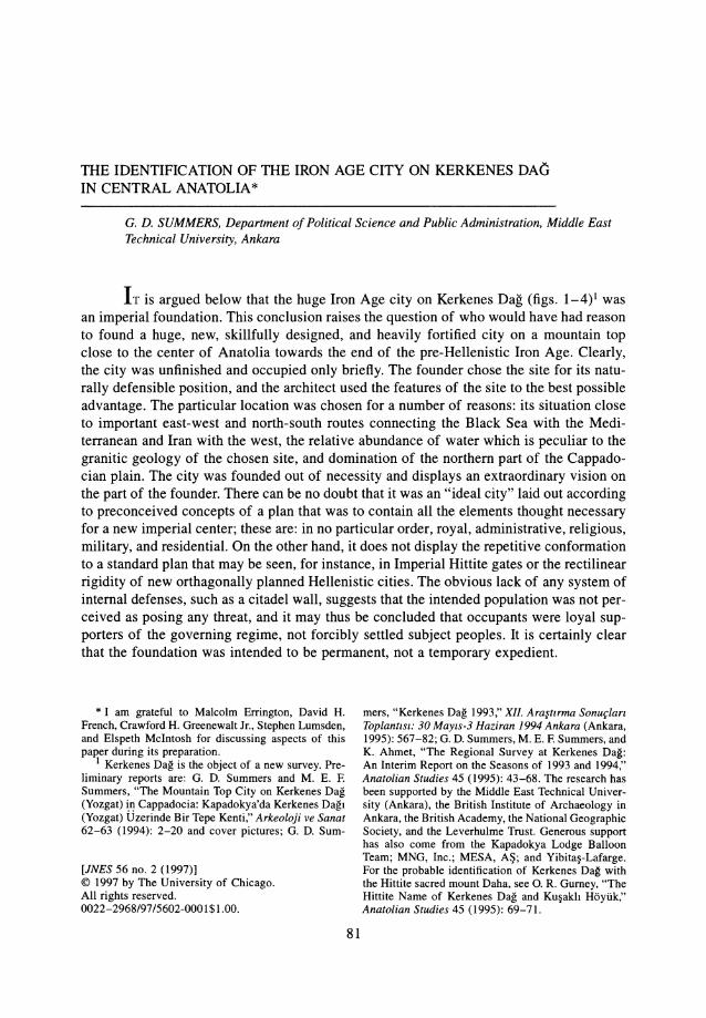
FIG. I.-Map showing the location of Kerkenes Dag in relation to the major geographical features of Anatolia
N
f
00N
~
oc~
~~
o"'rj
Zm;;I>~
m;;I>en....,m~Zen....,comen
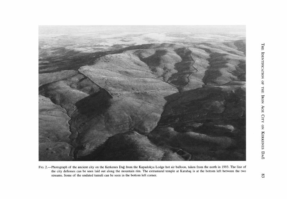
FIG. 2.-Photograph of the ancient city on the Kerkenes Dag from the Kapadokya Lodge hot air balloon, taken from the north in 1993. The line ofthe city defenses can be seen laid out along the mountain rim. The extramural temple at Karaba§ is at the bottom left between the twostreams. Some of the undated tumuli can be seen in the bottom left corner.
~:I:tIl
S'tIlZ:l'T1n~ozo'T1
-l
5i....:;0oz
5"tIl
n::;-<oz~tIl:;0;>::tIlZtIlC/}
tl;la,
00l.;.)
84
(()
METERS
JOURNAL OF NEAR EASTERN STUDIES
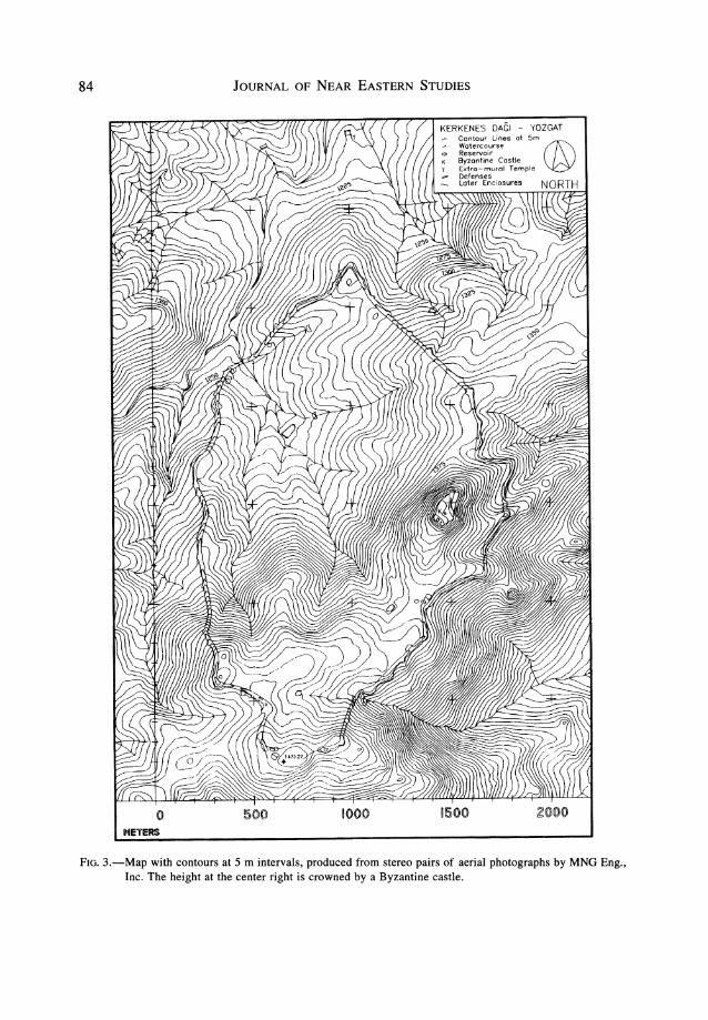
KERKENES DAGI - YOZGAT,- Contour Lines at 5m
Watercourse @ReservoirByzantine CastleExtra-mural TempleDefensesLater Enclosures
FIG. 3.-Map with contours at 5 m intervals, produced from stereo pairs of aerial photographs by MNG Eng.,Inc. The height at the center right is crowned by a Byzantine castle.
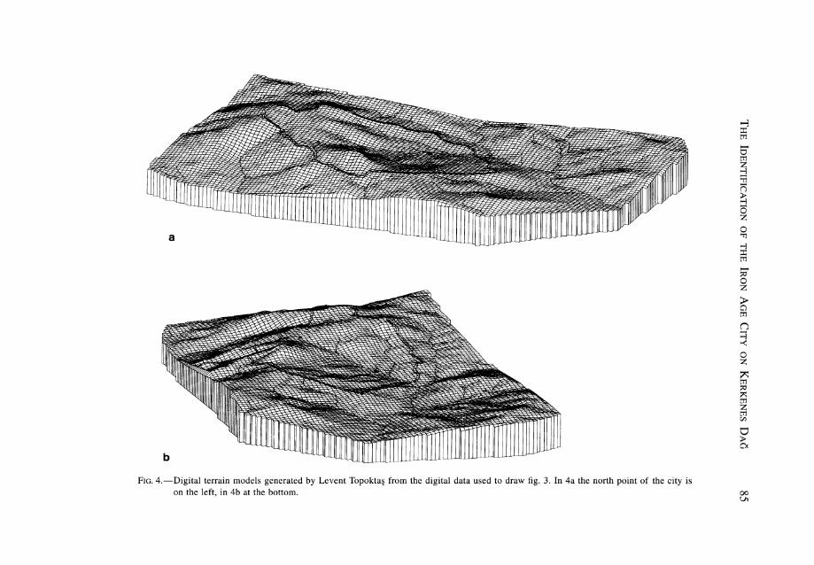
FIG. 4.-Digital terrain models generated by Levent Topokta§ from the digital data used to draw fig. 3. In 4a the north point of the city ison the left, in 4b at the bottom.
~::c:tT:1~otT:1Z~
;:jn~ozo~
~::c:tT:1~
~oz
~tT:1
n~~
oz~tT:1~~tT:1ZtT:1en
U:>0<
00Vl
86 JOURNAL OF NEAR EASTERN STUDIES
The date, based on pottery from the test excavations conducted by Erich Schmidt in1928,2 is within the rather loose period known as Alishar V, i.e, somewhere between theseventh and the fourth centuries B.C. It seems inconceivable, however, that it could be aPersian foundation for three reasons: (1) it is totally unlike any other known Achaemenidcity; (2) if it were Persian, it would surely have been the seat of a satrap, but it is not inthe correct place for one of the satrapies according to any of the much-debated reconstructions of Achaemenid geography; and (3) none of the finds are indicative of the Persianperiod. At the same time, an eighth-century date would seem to be ruled out by the pottery. A date in the seventh century, while it cannot be disproved, would have no historicalcontext. If an argument ex silentio is permissible, the likelihood is that construction andabandonment took place within the sixth century B.C.
It is perhaps reasonable to assume that so great a city, the largest pre-Hellenistic siteknown on the Anatolian plateau, founded and abandoned or destroyed somewhere withinthis time range, or indeed earlier, would have found mention in the ancient texts. The moreso, since, whatever the exact date, there is nothing of comparable stature known elsewhereon the Anatolian plateau. From among the ancient sources, there is only a single candidateand that is the city of Pteria mentioned by the ancient Greek historian Herodotus of Harlicanassus, "the father of history." The testimony of Herodotus is worth quoting in full:
Croesus, when he has crossed [the Halys River] with his army, came in Cappadocian territory, towhat is called Pteria. Pteria is the strongest part of all that country and lies in a line with the cityof Sinope, on the Euxine Sea. There he encamped, destroying the farms of the Syrians and he captured the city of the Pterians and made slaves of the people, and he captured all the neighbouringtowns; moreover he drove the Syrians from their homes, though they had done him no manner ofharm. Cyrus, on his side, gathered his own army, and took on, as well, all the peoples who livedbetween him and Croesus. (Before he set out to march at all, he sent heralds to the Ionians andtried to make them desert Croesus. But the Ionians would not listen to him.) So when Cyrus cameand encamped over against Croesus, then and there in that land of Pteria they fought against oneanother with might and main. The battle was fierce, and many fell on both sides. At last they brokeoff at the onset of night, without either having the victory; so hard did the two armies fight. 3
It will be helpful to recount the well-known historical background that led up to the Battleof Pteria before examining the implications of this passage from Herodotus in detail. Themost convenient starting point is perhaps the attack on the Neo-Assyrian capital Nimrudin 614 B.C. by the Medes and their subsequent alliance with the Babylonians. This wasfollowed by the fall of Nineveh to the combined forces two years later. In 605 B.C. theBabylonian king Nabopolasser defeated the remnants of the Assyrian army and their Egyptian allies at Carchemish and Hamath (modern Hama). The Neo-Assyrian Empire togetherwith the wider spheres of interest was divided between the Medes and the Babylonians: theMesopotamian part of the empire went to the Babylonians and the northern arena, fromHarran to the Anatolian plateau, to the Medes. In the space of ten years (614-605 B.C.),
the power of Assyria was broken and, after military defeat, the empire destroyed. The unlikely alliance between the Medes, newly emerging from east of the Zagros Mountains asa major power in the Near East, and the Neo-Babylonians, at the end of a three-thousand
2 E. F. Schmidt, "Test Excavations in the City onKerkenes Dagh," American Journal of Semitic Languages and Literatures 45 (1929): 83-92.
3 Herod. 1.76, in D. Grene, trans., Herodotus: TheHistory (Chicago, 1987).
THE IDENTIFICATION OF THE IRON AGE CITY ON KERKENES DAG 87
year tradition of urban civilization, fell into abeyance in the absence of a common enemy.Median strength was of sufficient magnitude for the Babylonians to have taken extensivedefensive measures, including the construction of a huge wall, impressively faced withbaked brick, to keep out the highly mobile and destructive menace. Sources for the following period of Median expansion are shadowy and much debated, the sources being Greekand Babylonian rather than Median and mostly somewhat later than events themselves.4 By590-589 B.C. the Medes were fighting the Lydians in central Anatolia, and thus the powerof Urartu in the highlands of eastern Anatolia and the Caucasus must have been reducedto insignificance. Urartu may have been completely under Median domination, for Cyaxares could hardly have campaigned towards the Halys River without being sure of securityin the rear. 5 The war between the Medes and the Lydians, perhaps best understood as aseries of annual campaigns with both protagonists fighting towards the practical limits imposed by distance from their respective home bases, lasted into a sixth year when on theafternoon of 28 May 585 B.C. it seemingly came to an end.
. . . war subsequently broke out between the two countries and lasted for five years, during whichboth Lydians and Medes won a number of victories. One battle was fought at night. But then, afterfive years of indecisive warfare, a battle took place in which the armies had already engaged whenday suddenly turned into night. This change from daylight into darkness had been foretold to theIonians by Thales of Miletus, who fixed the date for it for the year in which it did, in fact, take place.Both the Lydians and the Medes broke off the engagement when they saw this darkening of the day:they were more anxious than they had been to conclude peace, and a reconciliation was broughtabout by Syennesis of Cilicia and Labynetus of Babylon, who were the men responsible both for thepact to keep the peace and for the exchange of marriages between the two kingdoms. They persuaded Alyattes to give his daughter Aryenis to Astyages, son of Cyaxares-knowing that treatiesseldom remain intact without powerful sanctions.6
There have been numerous attempts to reconcile this and other passages from Herodotuswith the Neo-Babylonian sources,7 but the date of the war and the terms of the treaty havenot been questioned.8 The problem of reconciling the date of the treaty with the death ofCyaxares and the accession of Astyages is not insurmountable if it can be assumed thatAstyages was leading the Median forces in the west while his father was still on the thronein Ecbatana (the Median capital), a situation that has many parallels in the ancient world.9
That the Halys River formed the border between the empires of the Lydians and the Medesis well attested. 10 Whatever the nature and intensity of the war itself there are two pointsworth making: firstly, that the Medes were capable of challenging Lydian power in CentralAnatolia to such an extent that both Cilicia and far-flung Babylon saw it as being in their
4 P.-A. Beaulieu, The Reign of Nabonidus King ofBabylon (New Haven, 1989), p. 199. Only the buildinginscriptions of Nabonidus are certainly contemporarywith the events under discussion.
5 Urartu may have collapsed as early as 640 B.C.,
presumably under Scythian pressure. See, most recently, ~ Zimansky, "An Urartian Ozymandias," Biblical Archaeologist 58 (1995): 38-39.
6 Herod. 1.74, in D. Grene, trans., Herodotus.7 Most recently, Beaulieu, The Reign ofNabonidus,
passim.
8 But see G. Huxley, "A War between Astyagesand Alyattes," Greek, Roman and Byzantine Studies 4(1965): 201-6, for later sources that may suggestthat there were later hostilities between Astyages andAlyattes.
9 Ibid., p. 203, for an alternative view.10 J. G. Pedley, Ancient Literary Sources on Sardis,
Harvard Archaeological Exploration of Sardis 2 (Cambridge, Mass., 1972), p. 36, no. 107. For the possibilitythat earlier the Halys River formed the eastern boundary of Phrygia, see my article, "Grey Ware and the
88 JOURNAL OF NEAR EASTERN STUDIES
own interests to secure peace between the warring factions, and, secondly, the Medes couldcampaign on the Halys River without fear of serious attack from the rear.
Leaving aside the question of later hostilities between Astyages and Alyattes, the nextseries of events relevant to the story begins with the overthrow of Astyages and the establishment of the Achaemenid Empire by Cyrus the Great. By this time Alyattes was deadand his son Croesus, brother-in-law of Astyages, was on the Lydian throne. Croesus sawthe turmoil in the Iranian court as a time of dynastic weakness that provided him with anopportunity. Using the convenient, if not genuine, excuse of the murder of his brother-inlaw, and having sent envoys to various oracular temples from which he received what hecould only interpret as a favorable answer,11 he took his forces across the Halys River andsacked Pteria as recounted in the passage from Herodotus quoted above. The story was oneof the most famous in the Greek world. After the inconclusive battle between Croesus andCyrus, Croesus retreated to Sardis for the winter from where he summoned his allies inthe natural expectation that Cyrus too would withdraw for the winter and that the confrontation would be renewed in the following spring. 12 Cyrus, however, had superior forcesand, being a man of action and not about to let victory elude him, he went in immediatepursuit. 13 The oracle at Delphi had been correct. An empire was destroyed as a consequence of Croesus's action but not, as he had so confidently expected, that of the Persiansbut rather his own.
It is the contention here that Pteria was the city on the Kerkenes Dag and that this identification fits remarkably well with what little can be gleaned from both the ancient sourcesand the observable archaeological evidence. The location of the site fits well with thatgiven by Herodotus, as has long been realized. 14 It lies to the east of the Halys River andwithin Cappadocia. It is more or less due south of Sinope, and this is clearly what Herodotus intended the reader to understand. The position of Sinope on the Black Sea wouldhave been known to Herodotus himself and familiar to his readers, unlike the geographyof the interior. 15 The city, as has been argued above, was a new imperial foundation andwho better to have had the need of a strong base in such a position than Astyages, afterthe Battle of the Eclipse and the ensuing treaty, with a grand palace in which he could playhost to his new Lydian bride. The brief period of occupation would fit with the historicalrecord: founded soon after 585 B.C. and destroyed by Croesus some forty years later (seebelow for the discussion of the exact date). The site would be consistent with the need ofAstyages for a strong base east of the Halys River, and the lack of later occupation caneasily be understood because once Cyrus had exerted control over Lydia, the very reasonfor a strong base east of the Halys River no longer existed.
The argument is, admittedly, circumstantial and lacks the proof of inscriptions that wouldclinch the proposed identification. But there are additional arguments that, while not proof
Eastern Limits of Phrygia," in A. \:ilingiroglu and D. H.French, eds., Anatolian Iron Ages 3: Proceedings ofthe Third Iron Ages Colloquium Held at Van, 6-12 August 1990, British Institute of Archaeology at AnkaraMonograph 16 (London, 1994), pp. 241-52.
11 For a detailed discussion of the relationship between Croesus and the oracles, see C. D. Parke, "Croesus and Delphi," Greek, Roman and Byzantine Studies25 (1984): 209-32.
12 Herod. 1.77.
13 Cyrus perhaps chose the best of the alternativesopen to him. He would hardly have wanted to winter inthe highlands of the Anatolian plateau, and a return tohis Iranian homeland would have meant giving up hisrecent gains and risking having to cross the Zagrospasses in winter.
14 S. Przeworski, "Die Lage von Pteria," ArchivOrientdlnf 1 (1929): 312-15.
15 Ibid., p. 313. Herodotus clearly places Pteria inCappadocia, and thus it cannot have been in close prox-
THE IDENTIFICATION OF THE IRON AGE CITY ON KERKENES DAG 89
in themselves, combine to make a strong case. Firstly, there is no good parallel for the cityin Anatolia and no obvious precursor for its genesis. Secondly, the complexes are veryspacious, hardly intended to contain a large and crowded population such as might beexpected if it had been conceived and constructed as a refuge and haven for a local population; rather, it gives the impression of having been designed for a relatively small elitepopulation. In other words, it was founded for a foreign, colonial, imperial community.Some hint of the correctness of this interpretation may be extracted from the testimony ofHerodotus quoted above. It is striking that Croesus treated the inhabitants of Pteria differently from the "Syrians" in the surrounding villages who, in contrast to the Pterians, haddone no wrong. It can thus be argued that the phraseology of Herodotus implies that theinhabitants of Pteria were not the same as the rural population, an implication that can easily be understood if the occupants of the city were Medes and their allies: a foreign occupying power. The design and construction techniques of the defenses, the "palace" and theextramural temple at Karaba~,16 have no exact parallel known in Anatolia and neither dothe enclosures and other architectural features (figs. 5-7). If it is correct to assume that theelements of the city plan and the architecture were the culmination of a well-establishedand long-standing tradition, an assumption that might be reinforced by the skill evident inthe layout and execution, then Ecbatana with its legendary seven city walls might be expected to have provided the inspiration. 17 Some elements of the site, such as the "palace"terrace and the skillful regulation of the water supply might be further hints of an easterntradition. All this, of course, is speculation, and our knowledge of other sixth-century citiesin Anatolia is currently so sparse that it may be unwise to place too much weight on negative evidence.
One further aspect of the ancient city may, with special pleading, be suggestive of an eastern connection. The altitude, ca. 1,400 m, is such that winters are both long and extremelycold, and the site is very exposed (unlike modern Anatolian cities at similar altitudes suchas the nearby provincial center of Yozgat, which is somewhat protected by surroundingmountains). It is difficult to imagine the whole city population living through the winterout of choice and, incidentally, easy to see why the site did not attract later urban dwellers.The idea of a seasonal city brings to mind the successive Achaemenid tradition of seasonalmigration between summer and winter cities. If the population was indeed foreign, as hasbeen argued above, it might be wondered where the winter residence was. Of this there isno evidence, but from Kerkenes frequent views of snow-capped Erciyas Dag rising above
imity to the city of Sinope. Herodotus does not name aterritory to the north of Cappadocia, so that it is sometimes assumed by modern commentators that Cappadocia extended as far as the Black Sea; but Herodotusdid not mean to imply that Sinope was in Cappadocia.This was long ago understood by W. M. Ramsay, Historical Geography of Asia Minor (London, 1890), pp.28-33, although there is no basis for assuming thatthe Persian Royal Road ran to Pteria, which, accordingto the hypothesis expounded here, was deserted afterthe destruction wrought by Croesus. Ramsay acceptedthe identification of Bogazkoy with Pteria proposedby Texier before it was realized that it was the capitalof the Hittite Empire. Hattusa is 50 km from Kerkenesas the crow flies, and its relative isolation makes manyof the suggestions proposed by Ramsay in support of
the equation better suited to Kerkenes. In a paper soonto be published, David French has convincingly arguedthat route of the Royal Road was in fact further to thesouth. I am most grateful to David French for showingme his paper in advance of publication, for discussionon roads and routes in general, and much else.
16 See G. D. Summers et aI., "The Kerkenes Dag Survey: An Interim Report," Anatolian Studies 46 (1996):201-34, pIs. 23-40.
17 For a Median city at Mespila (? modern Mosul)with a "kind of palace" and stores for the satrap, and forMedian Nineveh, see J. Oates in J. Boardman, I. E. S.Edwards, N. G. L. Hammond, and E. Sollberger, eds.,The Cambridge Ancient History, vol. 3, pt. 2 (Cambridge, 1975), p. 90.
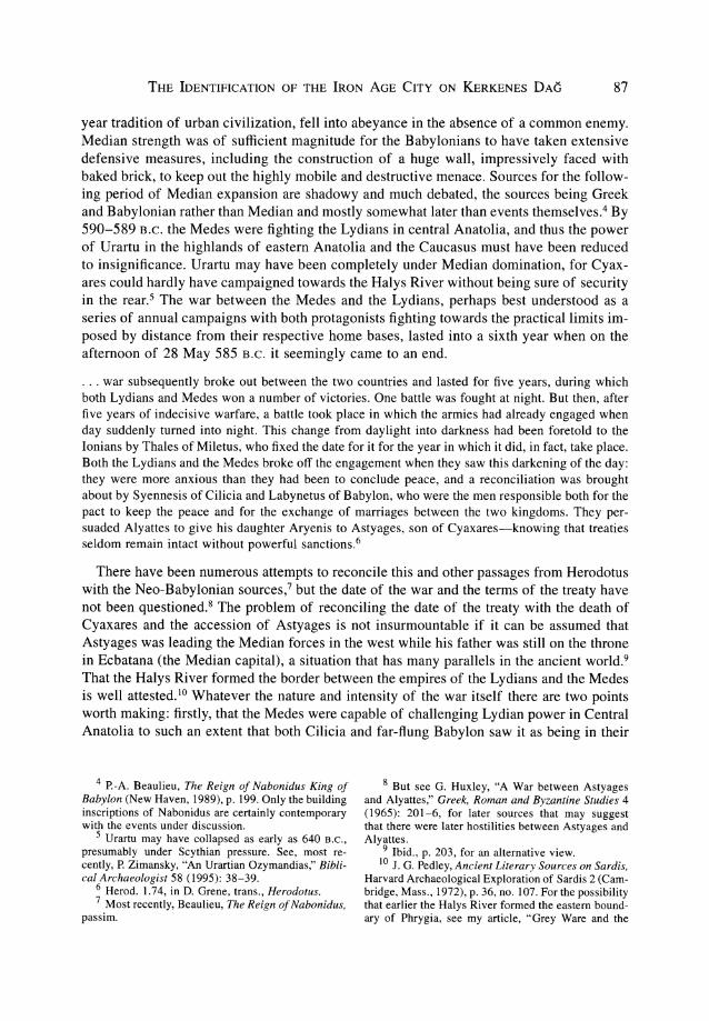
FIG. 5.-Low level photograph taken by remote control from a helium-filled blimp. The area, ca. 230 x 150 m, is just inside the angle in the northeasternstretch of city wall (extreme left in fig. 2), which, in its ruinous state, can be seen at top right. Remains of compounds and buildings, a street,and a small circular reservoir stand out. The outcropping bedrock provided a ready source of building stone.
\0o
......oc:::;.:I
~t"'"
o'T]
ZtTl>:;.:I
tTl>en...,tTl:;.:IZen...,c::omen
THE IDENTIFICATION OF THE IRON AGE CITY ON KERKENES DAG 91
AREA BSho.de Plot(co press)
20 ,..
DRTH
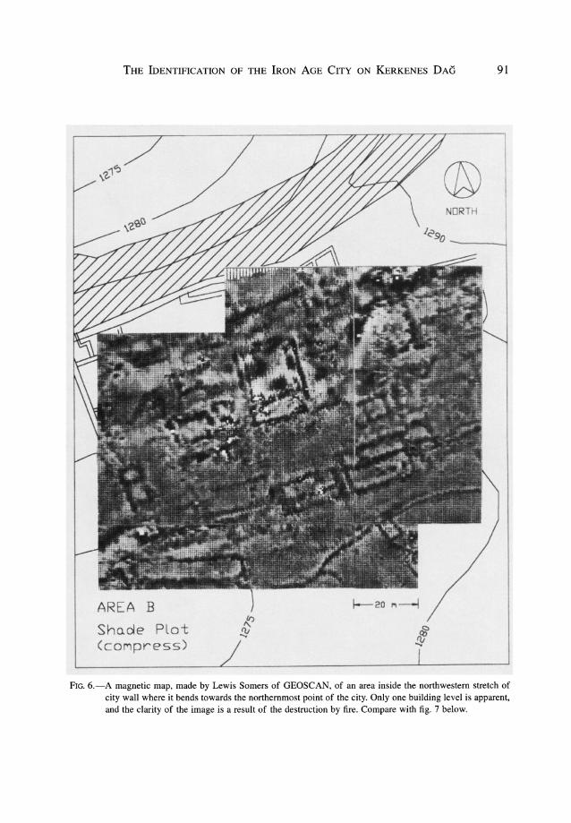
FIG. 6.-A magnetic map, made by Lewis Somers of GEOSCAN, of an area inside the northwestern stretch ofcity wall where it bends towards the northernmost point of the city. Only one building level is apparent,and the clarity of the image is a result of the destruction by fire. Compare with fig. 7 below.
92 JOURNAL OF NEAR EASTERN STUDIES
I/
/
~/)
20I
50 ..
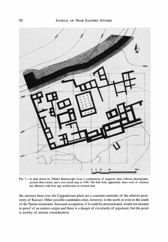
FIG. 7.-A plan drawn by Niltifer Baturayoglu from a combination of magnetic data, balloon photographs,ground observation, and a test trench dug in 1996. The hall with, apparently, three rows of columnshas affinities with Iron Age architecture in western Iran.
the summer haze over the Cappadocian plain are a constant reminder of the relative proximity of Kayseri. Other possible candidates exist, however, to the north or even to the southof the Taurus mountains. Seasonal occupation, if it could be demonstrated, would not amountto proof of an eastern origin and there is a danger of circularity of argument, but the pointis worthy of serious consideration.
THE IDENTIFICATION OF THE IRON AGE CITY ON KERKENES DAG 93
Although the arguments set out above do not amount to proof, they culminate in a strongcase. If the city on Kerkenes Dag cannot be identified with Pteria, the problem of who didbuild it remains. Further, the date would surely need to be revised, for it is most unlikelythat the Medes would have allowed such a position of strength to have been establishedduring the period when they were fighting the Lydians. If it had been constructed by somelocal power attempting to assert independence, and destroyed rather than built by the Medes,the ambitiousness of the scheme is surprising and the failure of the Medes to take overrather than desert the site would need some explanation.
The location of a major center so far to the north deserves comment, particularly if thePersian Royal Road is further to the south. 18 From the Median point of view they wouldhave wanted to keep as far north of the Babylonian threat as possible, and it can thus besurmised that their forces would have preferred to cross the Zagros by one of the morenortherly passes and to have followed the modern route rather than to have risked confrontation with Babylonian forces in northern Mesopotamia. The Persian Royal Road, onthe other hand, postdates the capture of Sardis and perhaps the incorporation of Babyloniainto the Achaemenid Empire. It may also be that the foothills of the Pontic mountains wereperceived as being more desirable than the hot, dry plains of the plateau and logisticallyeasier in terms of water and supplies. 19 Under the Achaemenids, the cities of the southernPontus became Iranianized to the extent that eastern cults remained strong until they wereovertaken by Christianity. In the seventh century A.D. the Sassanian Persians showed interest in the same area and followed similar routes as far westward as Ankara. It has beenargued, admittedly on rather thin evidence, that the effect of these Persian raids was feltin the countryside around Kerkenes Dag.20 It is likely that the attractions of the northerlyroute were the same in the Sassanian period as they were some 1,300 years earlier.
Two arguments may be put forward against the identification of the city on the KerkenesDag with Pteria: firstly, there is no (known) Median precedent for such a huge city and,secondly, that the Medes would not have had the power and organizational skills to conceive of and build on the scale of Kerkenes. To the first of these objections there is no goodanswer, although nothing is known about the physical city of Ecbatana, the Median capita1. 21 Lack of precedent, however, is an argument that, at least on present knowledge,would apply to any hypothesis concerning the foundation of the city. Passargadae andPersepolis, not much later in time, are evidence of a cultural tradition that was capable ofproducing new and startling innovations. The second objection, like the first, is based onnegative evidence. It has been seen that the Medes fought the Lydians on the Anatolianplateau for more than five years. Further, in 614 B.C., it was the Medes who attacked
18 D. H. French, forthcoming and n. 15 above.19 See my article, "Archaeological evidence for the
Achaemenid Period in Eastern Turkey," Anatolian Studies 43 (1993): 85-108, for the importance of this routein the Achaemenid period and the possibility that Pontic silver was one stimulus. It is futile, in the absenceof evidence, to speculate on what importance the Medesplaced on contacts with the Greek colonies on theBlack Sea.
20 C. Foss, "The Persians in Asia Minor at the End
of Antiquity," The English Historical Review 90 (1975):739, reprinted in idem, History and Archaeology ofByzantine Asia Minor (Aldershot, 1990), pp. 721-42.The argument is largely based on a small number ofcoins from Ali~ar Hoylik and a lack of late inscriptions.
21 B. Gentio, "The Medes: A Reassessment of theArchaeological Evidence," East and West 36 (1986):38-62, has discussed the archaeological evidence. Inany case, Hamadan is a very big mound and quitedifferent from the mountain-top city on Kerkenes Dag.
94 JOURNAL OF NEAR EASTERN STUDIES
Nineveh and Calah, captured Tarbi~u, and destroyed Assur.22 The "mighty enemy" againstwhom Nabopolassar built the "Median Wall" surely included the Medes, even if they didnot comprise solely the Medes. 23 The strength of this wall, which ran from the Tigris tothe Euphrates, is very impressive, and its construction would have involved very considerable labor and expense. It was built against a threat that was perceived to be very real andmay thus give an impression of the strength that the Medes were thought to be able tomuster.
In conclusion, it has been argued that the city on the Kerkenes Dag in Central Anatoliawas the city of Pteria mentioned by Herodotus. Further, it has been suggested that this citywas built by the Medes after the conclusion of their war with Lydia that ended in 585 B.C.
and that the city was still incomplete when it was destroyed by Croesus in 545 B.C. Thearguments adduced in favor of this identification include recent archaeological data thatprovide evidence for the "imperial" foundation, the short occupation, and the destruction,as well as the evidence of historical geography. Although the arguments combine to makea strong case, the proof of inscriptions or of exact date has yet to be found. The identification has far-reaching consequences for an understanding of the nature of Median expansionand control, and for the successive Achaemenid Empire.
ADDENDUM
1. In the summer of 1996 limited test trenches were dug under the auspices of the YozgatMuseum. The results fully substantiate the arguments set out here for a short-lived IronAge city ultimately put to the torch. Evidence for wealthy aristocratic residences (fig. 7)and "imperial stables" was recovered. Direct evidence for the identification of the city,however, remains elusive, and its equation with Pteria still rests on the arguments setout above.
2. Stephanos of Byzantium, as Przeworski noted,24 lists both Pteria near Sinop and Pterion(alternatively Pteria), a city of the Medes. David French has suggested to me (personalcommunication, 27 October 1996) that Stephanos was using an ancient source, now lost,and that, whether or not there were two Pterias, Stephanos's association of the namePterion/Pteria with the Medes supports the identification of the Median city on theKerkenes Dag with Herodotus's Pteria.
22 Cambridge Ancient History, vol. 3, pt. 2, p. 179.23 Ibid., pp. 238, 249 and R. D. Barnett, "Xenophon
and the Wall of Media," Journal ofHellenic Studies 83(1963): 1-26. For the identification of the "MedianWall" with the remains of an immense structure, seeR. G. Killick, "Northern Akkad Projects: Excavations
at Habl as-Sar," Iraq 46 (1984): 125-29; J. A. Blacket aI., "Babl a~-Sabr 1983-85," Northern Akkad ProjectReports 1 (1987): 3-46; and C. A. Baud et aI., "Babla~-Sabr 1986, nouvelles fouilles," Northern Akkad Project Reports 2 (1989): 23-70.
24 Przeworski, "Die Lage von Pteria," p. 315, n. 4.