Embed Size (px)
Citation preview
THE DEVELOPMENT OF INFORMAL SETTLEMENTS IN DORAYI, KANO AS CASE
STUDY
A THESIS SUBMITTED TO THE GRADUATE SCHOOL OF APPLIED SCIENCES
OF NEAR EAST UNIVERSITY
By UMAR ABDULLAHI AMINU
In Partial Fulfillment of the Requirements for
The Degree of Master of Science in
Architecture
NICOSIA, 2020
UM
AR
ABD
ULLA
HI TH
E DEV
ELOPM
ENT O
F INFO
RM
AL SETTLEM
ENTS IN
DO
RA
YI, N
EU
A
MIN
U
KA
NO
CA
SE STUD
Y
2020
THE DEVELOPMENT OF INFORMAL SETTLEMENTS IN DORAYI, KANO AS CASE
STUDY
A THESIS SUBMITTED TO THE GRADUATE SCHOOL OF APPLIED SCIENCES
OF NEAR EAST UNIVERSITY
By UMAR ABDULLAHI AMINU
In Partial Fulfillment of the Requirements for
The Degree of Master of Science in
Architecture
NICOSIA, 2020
Umar Abdullahi Aminu: THE DEVELOPMENT OF INFORMAL SETTLEMENTS IN DORAYI, KANO AS CASE STUDY
Approval of Director of Graduate School of Applied Sciences
Prof. Dr. Nadire ÇAVUŞ
We certify this thesis is satisfactory for the award of the degree of Masters of Science in Architecture
Examining Committee in Charge: Assoc. Prof. Dr. Buket Asilsoy
Committee Chairman, Supervisor, Department of Landscape Architecture, NEU
Prof. Dr. Zeynep Onur Üstün
Head of the Department of Architecture, NEU
Assist. Prof. Dr. Enis Faik Arcan
Department of Architecture, NEU
I declare that, this thesis is independently carried out by me under the supervision and
guidance of Professor José Manuel Pagés Madrigala and Associate Professor Buket Asilsoy.
In addition, I hereby declare that all information in this document has been obtained and
presented in accordance with academic rules and ethical conduct. I also declare that, as
required by these rules and conduct, I have fully cited and referenced all material and results
that are not original to this study.
Name, Last name: Umar Abdullahi Aminu
Signature:
Date: December 2019
ii
ACKNOWLEDGMENTS
This work would not have been possible without the support of my supervisor Assoc.
Professor Buket Asilsoy and Professor José Manuel Pagés Madrigal achieving tremendous
support, guidance, courage, and feedback from the beginning to the end.
I will always honor my dear parents and relatives; your love, patience, and prayers have been
resourceful in making this work a reality. Your support and encouragement throughout my
entire B.Arch. and MSc journey shall forever be remarkable. I am however particularly
grateful to my Kundila’s family, I remain very grateful to you all.
The list goes on and on; many special warmest thanks to Adam A Aminu, AbdulRahman A
Aminu, AbdulMajeed H Muhammad, Aliyu Bashir, Dayyab Safyan, Hakeem H Yahya,
Khalil AbdulWahab, Yusuf Kabir and all my friends for their friendship and support
contributing to the success of my study. There are too many people to acknowledge for their
support and influence that I can hardly fit within a single page.

To my parents…
iv
ABSTRACT
Housing is always a controversial issue, especially in developing countries. It has a strong
relation with the quality of life. However, nowadays the development of informal settlements
is deeply affecting the pattern of urban developments in the developing cities. Nigeria, as
one of these countries, shares the problems related to this issue. Forty-six percent of houses
in Nigeria have related problems, resulting largely from inadequately planned land use and
non-secure land tenure, weak development management, poor construction and poverty. In
other words, slums are a direct consequence of the imbalances we can see in this country,
especially from the social and economic point of view.
In brief with a focus on Nigeria, this thesis examines the phenomenon of informal
settlements and approaches to its management. The main purpose of this study is to
investigate the development of informal settlements in Kano metropolitan area. For this
reason, after introducing the research objectives, the study evaluates the definition of
informal settlements within disparate dynamics. Then, it examines examples from some
international countries. Later the study tries to explain how informal settlement has
developed in Kano for finding answers on these phenomena and how can be upgraded and
progressively combined into the urban development mainstream.
The methodology of this study is based on qualitative method; the data was collected through
literature review and international cases. In addition, Dorayi in Kano was evaluated as a case
study. Finally, it concluded with a guideline proposal in order to be used for improving the
informal urban environments of Kano metropolitan area, Dorayi in particular, through
necessary upgrading.
Keywords: Informal settlements; urban upgrading; case study; Kano, Dorayi

v
ÖZET
Konut, özellikle gelişmekte olan ülkelerde her zaman tartışmalı bir konudur. Yaşam kalitesi
ile güçlü bir ilişkisi vardır. Bununla birlikte düzensiz yerleşim yerlerinin gelişimi
günümüzde, gelişmekte olan kentlerdeki kentsel dokuyu derinden etkilemektedir. Nijerya,
bu ülkelerden biri olarak, bu konuyla ilgili sorunları deneyimlemektedir. Şöyle ki,
Nijerya'daki evlerin yüzde kırk altısı büyük ölçüde, yetersiz planlanan arazi kullanımı,
güvenli olmayan arazi kullanım hakkı, zayıf kalkınma yönetimi, zayıf inşaat ve yoksulluktan
kaynaklanan sorunlara sahiptir. Diğer bir ifadeyle, özellikle sosyal ve ekonomik açıdan
gecekondular, bu ülkedeki dengesizliklerin doğrudan bir sonucudur.
Özetle bu tez Nijerya'ya odaklanarak, düzensiz yerleşim olgusunu ve yönetimine
yaklaşımları incelemektedir. Bu çalışmanın temel amacı, Kano metropol bölgesindeki
düzensiz yerleşim alanlarının gelişimini araştırmaktır. Bu sebeple çalışma, araştırma
kapsamını ortaya koyduktan sonra, öncelikle farklı dinamikleriyle düzensiz yerleşim
alanlarını değerlendirir. Daha sonra bazı ülkelerden uluslararası örnekleri inceler. Ardından,
Kano'da düzensiz yerleşimin nasıl geliştiğini açıklamaya çalışır. Daha sonra çalışma,
düzensiz yerleşimin nasıl geliştirilebileceğine ve aşamalı olarak kentsel gelişime nasıl dahil
edilebileceğine cevap bulmak maksadıyla, Kano'daki gelişimi irdelemektedir.
Bu çalışmanın metodolojisi nitel yönteme dayanmaktadır; veriler, literatür taraması ve
uluslararası çalışmalar yoluyla toplanmıştır. Ayrıca bir vaka çalışması olarak ise Kano’daki
Dorayi değerlendirilmiştir. Çalışma son olarak, Kano bölgesindeki, özellikle Dorayi'nin
kentsel çevresini iyileştirmek için kullanılabilecek şekilde, bir kılavuz önerisi ile son
bulmaktadır.
Anahtar Kelimeler: Düzensiz yerleşim; kentsel iyileştirme; vaka çalışması; Kano, Dorayi
vi
TABLE OF CONTENTS
ACKNOWLEDGMENTS ………………………………………………………….. ii
ABSTRACT ……………………………………………………………………….… iv
ÖZET ………………………………………………………………………………... v
TABLE OF CONTENTS …………………………………………….………...….... vi
LIST OF FIGURES ……………………………………...………………………….. viii
LIST OF TABLES …………………………………………………………………... ix
LIST OF ABBREVIATIONS ………………………………………………………. x
CHAPTER 1: INTRODUCTION
1.1 Research Problem ……………………………………………………………….... 2
1.2 Research Objectives …………………………………………………………….... 7
1.3 Hypothesis ………………………………………………………………………... 8
1.4 Methodology …………………………………………………………...………… 8
1.5 Expected Results of the Research ………...…………………………………....…. 9
CHAPTER 2: AN EVALUATION OF INFORMAL SETTLEMENTS
2.1 Housing and Urban Environments in Contemporary Cities …..….………..….…... 11
2.1.1 The issue of informal settlements …………….…………………..………..... 13
2.2 Theoretical Framework for Informal Settlements …….………………...………… 15
2.3 Urban Typologies of Informal Settlements ……………………………………….. 20
2.4 Weak Planning and Management of Cities …….……………………...………….. 22
2.5 Evolution of Informal Settlements in Nigeria …..….…………………….……….. 25
2.6 National Approach for Dealing with Informal Settlement in Nigeria ……………... 27
CHAPTER 3: INTERNATIONAL SAMPLES OF INFORMAL SETTLEMENTS
3.1 Rio de Janeiro in Brazil ……………………………….….……………………….. 30
3.1.1 The Favela Bairro development ……………………….……..……..….….... 31
3.1.2 Favela Bairro impartial …………………………………………………….... 32
3.1.3 Favela’s project ……………………………………………………………... 34
3.2 Nairobi in Kenya ………………………...……………………...…..……………. 35
vii
3.2.1 KENSUP and KISIP projects ……………………………………………….. 36
3.2.2 KENSUP and KISIP dynamics of achievement …………………………….. 38
3.3 Summary of the cases …………………………………………………………….. 39
3.4 Samples of Informal Settlements Upgrading …………………...…..…………….. 41
3.4.1 Yantai’s upgrading projects in China ……………………………………….. 42
3.4.2 Exemplifications of informal settlements in Africa ………………………..... 43
3.4.2.1 Egypt …….……………………...……………………...…………... 43
3.4.2.2 South Africa ………………………...……………..…………..……. 46
CHAPTER 4: INFORMAL SETTLEMENTS IN KANO, NIGERIA
4.1 Kano City ………...……………………....……..………………………………... 48
4.2 Urban Morphologies in Kano ……………………………………………….……. 52
4.2.1 Green areas ………...……………………………………………….……….. 53
4.3 Analysis of Informal Settlements in Kano, Nigeria …………………...…...……... 60
4.3.1 Formal settlements …………………………………...….……………..….... 61
4.3.2 Informal settlements …………………………………….……………….….. 65
4.4 A Case Study: Dorayi in Kano City …..….…………………………………....….. 66
4.4.1 Analysis of Dorayi as case study …………….…………..…………………. 67
CHAPTER 5: CONCLUSION & RECOMMENDATIONS
5.1 Conclusion ………………………………...…..….…………………….………... 75
5.2 Recommendations ………………………………………………….…..……….... 76
REFERENCES …...……………………………….…………………………...…..... 79
viii
LIST OF FIGURES
Figure 1.1: An above photo of Kano City …….……….………...…………………… 3
Figure 1.2: Formal and informal differences Kano city …….……….………...……... 4
Figure 1.3: Formation of slums ………………………………………………………. 5
Figure 2.1: World population growth & urbanization ………………………………... 11
Figure 2.2: Drone photo of Mumbai reveals the places where extreme poverty meets
extreme wealth …….…....………...…….….…………………………….
18
Figure 2.3: Construction of 250 units of houses at Millennium City, Kaduna …….….. 28
Figure 2.4: Kaduna millennium city master plan …………………………………….. 28
Figure 3.1: Telling the story of the Favelas through art and literature ………………... 30
Figure 3.2: Favela Bairro project; Developing solutions Rio de Janeiro ……………... 34
Figure 3.3: A pleasant open space instead of illegal structures in an upgraded Yantai
neighbourhood …….…....………...…….….…………………………….
42
Figure 3.4: Mubarak Youth Housing Project ………………………………………… 45
Figure 4.1: Kano state map, Nigeria ……………………………......……………….... 48
Figure 4.2: Morphological urban transformation Kano city ………………………….. 52
Figure 4.3: Morphological differences in formal and informal region in Kano about
road, building and green area ……………………………………………..
54
Figure 4.4: Kano urban green areas …………………………………………………... 55
Figure 4.5: The level of accessibility in Kano ………………………………………... 59
Figure 4.6: Morphological areas in Kano ………………………………...……….….. 61
Figure 4.7: Morphological differences in formal and informal area of Kano ………… 64
Figure 4.8: Dorayi in Kano as case study area ………………………………….…….. 66
Figure 4.9: Area view of Dorayi informal settlement in Kano ……………………….. 67
Figure 4.10: Dorayi accessibility …………………………………………………….. 69
Figure 4.11: Accessibility to Dorayi, street size …….....……………………………... 69
Figure 4.12: Building structure of Dorayi ……………………………………………. 70
Figure 4.13: Public tap in Dorayi …………………………………………………….. 71
Figure 4.14: Drainage and waste system in Dorayi ……………………..……………. 72
Figure 4.15: Power supply alternative in Dorayi ……………………………………... 73
Figure 4.16: Poor implementation of basic education in Dorayi ……………………... 74
ix
LIST OF TABLES
Table 2.1: Population urbanization and poverty in Africa …………………………… 15
Table 3.1: Favela Bairro planned and accomplished objectives ……………………… 33
Table 3.2: Satisfaction with main services …………………………………………… 34
Table 3.3: KENSUP and KISIP main scope of work ………...…………...………….. 36
Table 3.4: The achievements have been made: KENSUP and KISIP outcomes ……... 37
Table 3.5: Samples of informal settlements redevelopments their success projects ….. 39
Table 4.1: Kano inter-regional hierarchy of marketing towns in the trans-Sahara
trading route ……………………………………………………………..
50
Table 4.2: The level of accessibility in Kano …………………………...…………..... 59
Table 4.3: Kano residential area illustration …………………………..…………….. 60
x
LIST OF ABBREVIATIONS
AFD: The Agence Française de Développement
CBO: Congressional Budget Office
FRN: National Population Commission
GOK: The Government of Kenya
GOPP: The General Organization of Physical Planning
GRA: Government Residential Area
IASC: The Interagency Steering Committee
IDB: The Inter-American Development
IOM: International Organization for Migration
ISDF: The Informal Settlements Development Facility
ISESCO: Islamic Educational, Scientific and Cultural Organization
KENSUP: The Kenya Slum Upgrading Project
KISIP: The Kenya Informal Settlement Improvement Program
LMDGP: Lagos Metropolitan Development and Governance Project
M&E: Monitoring and Evaluation
MCI: Millennium Cities Initiative
MCP: Millennium City Project
MDG: Millennium Development Goals
NCP: NEPAD City Project
NEPAD: The New Partnership for Africa's Development
NGO: Non-Governmental Organization
NUA: The New Urban Agenda
SAP: Structural Adjustment Programme
SEC: The Settlement Executive Committee
SCP: The Sustainable City Project
SIDA: The Swedish International Development Cooperation Agency
UNESCO: The United Nations Educational, Scientific and Cultural Organization
UNCHS: The United Nations Centre for Human Settlements
UNIDO: The United Nations Industrial Development Organization
1
CHAPTER 1
INTRODUCTION
Informal settlements are emerging as dominant slums arising in all cities where the social
differences are more evident. However informal settlements might be one of the most
challenging tasks within urban development. Nowadays, in many cities in developing
countries, including Nigeria, an important percentage of the population are living in slums
or informal areas. These informal settlements are usually taking place in suburban and urban
surroundings. We can define informal settlements by certain criteria such as self-build hou-
sing, sub-standard services, and resident’s low incomes, and this proliferation of informal
settlements is as a result of rapid development of urban areas in developing countries. This
phenomenon is particularly strong in the urban evolution of settlements of Sub-Saharan
Africa. The need for housing is physical, as it serves as an abode for almost all human
activities, such that even those who cannot afford still need them.
The development of informal settlements is the term used to portray non-lawful of buildings
or land. The UNCHS characterizes this pointer as pursues: “the residence alludes to the
privileges of family units over the housing and land they involve, especially rights over
land”. This incorporates “family units in informal housing or housing which has no title to
the land on which it stands, and who pay no rents just as families in squatter housing that
pay rent” (Napier, 2004).
The existence and growth of informal settlements in the cities have a major environmental
effect. Millions of urban poor are living on marginal lands, with a lack of access to secure
land, unguarded to flooding, avalanches, and other environmental hazards, more than 230
million residents live in an informal area in developing nations, which are just about one out
of six Commonwealth natives. In a fourth of Commonwealth nations (11 African, 2 Asian
and 1 Pacific) more than two out of three urban tenants live in a slum and a significant
number of these nations are urbanizing quickly (Habitat, 2006). According to the (UN, 2010)
there are presently 200,000 informal neighborhoods over the world, the greater part of them
in and around urban areas and that number is developing exponentially. Indeed, even before
the financial crisis of 2007-2008, around 33% of all city tenants lived in a slum, and it is
2
required to develop by one billion people within the following 20 years (Tovrov, 2011).
However, 75% of the world's developing nations are in informal settlements, for example,
Nigeria, as one of these countries, shares the problems related to this phenomenon. In spite
of the fact that the structure, size, and development of informal areas across sub-Saharan
Africa. The UN-Habitat has characterized the informal settlement as absence of access to
satisfactory water supply, absence of access to sufficient sanitation offices, lacking living
zone, deficient solidness of residences and residency instability (Tester, 2012).
1.1 Research Problem
Having a lot of urban developments in rapidly developing countries, Nigerian cities have
experienced informal developments in which lands have been informally plotted and traded
to householders who have built their own houses. The way they used some of the lands is
conceded unsafe or unfit for the planned residential developments. For instance, some of the
lands are reserved for future developments such as roads, railway tracks, green areas, parks.
Nigeria's urban development, similar to its populace, is one of the most elevated in Africa;
the present extent of the population living in urban areas is forty-seven percent. Out of the
assessed 190 million Nigerians, 78 million are living in urban areas. Contrasted with a
portion of the nations in Africa and other developing regions, it has perhaps the highest rates
of urban development. For instance, in India one of the world's most crowded countries, just
around thirty percent is urban. Likewise, in the Democratic Republic of Congo, which has a
generally high populace in central Africa, about thirty-three percent are in the rural centers,
this left around seventy percent in the urban areas. In Burkina Faso, just around nineteen
percent of the populace is in urban areas. South Africa, on the other hand, has a higher rate
of urban concentration than Nigeria, with a little more than sixty percent of its populace is
urban centers. Patterns of urban development in Nigeria demonstrate that the urban populace
dramatically increased from 1950 to 1975 from ten percent to twenty-five percent. It
recorded another quick development between 1975 to 2000 expanded to forty-two percent
and present projections demonstrate that it will ascend around fifty percent by 2010 (UN-
Habitat, 2007).
3
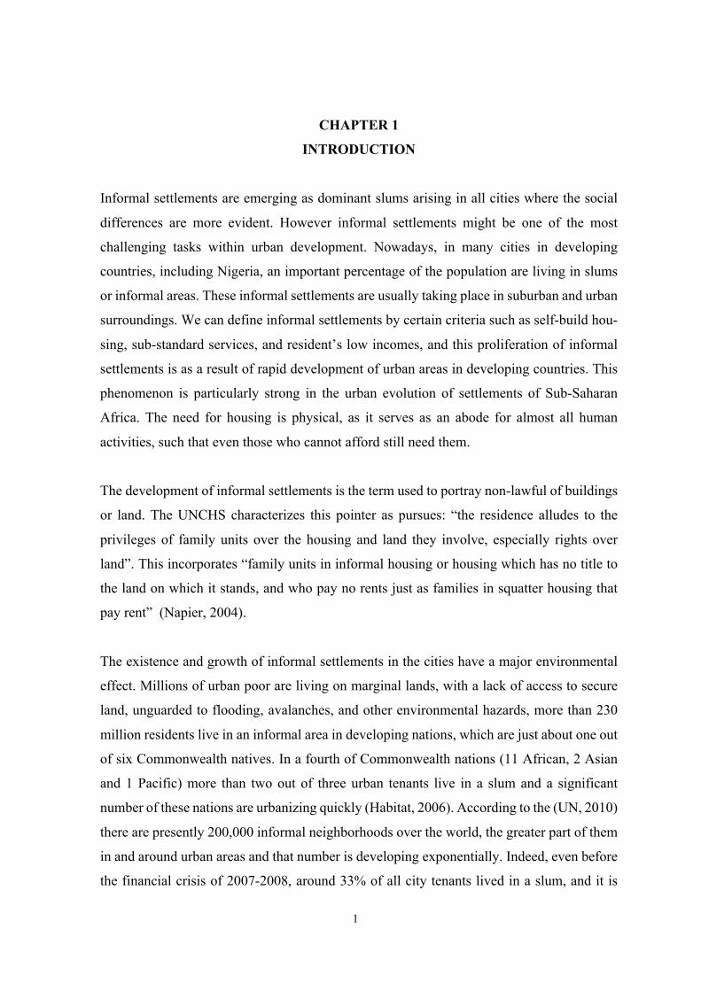
These phenomena are one of the biggest challenges facing the Nigerian metropolitan area of
Kano, which is basically as a result of large-scale migration to the suburban areas. Formal
settlements by definition are mapped sufficiently for most purposes. However, for informal
settlements, due to their material and instability, the detection of these settlements is
substantially more difficult. See Figure 1.1.
Figure 1.1: An above photo of Kano City (Davidehrhardt.com)
Nigeria as a developing country, with 36 states, it is a nation that is blessed with agriculture
and crude oil. Its significant wellspring of revenue and income was from agricultural produce
yet after the oil boom during the 1970s, Nigeria began moving its focus from agriculture to
crude oil in 2007. Nigeria was the 15th biggest oil manufacturer on the planet. Additionally,
it has one of the fastest developing media transmission markets. Nonetheless, this country is
experiencing a rapid development of urbanization. Due to these deviations from agriculture,
and a tremendous advancement in the urban regions, high populations of people move from
rural to urban areas looking for employments to acquire a more significant compensation
and to accomplish an alternate income. So the followings can be summarized with regards
to Nigeria;
§ Fast urbanization process according to the fast growth of the economy
§ This urbanization carried some problems and created urban inequalities i.e. slums
are direct consequences of it
4
§ One of the characteristics of the slums is the ghettoization and the lack of
connectivity with the main urban shapes, as well as the lack of elementary urban
services
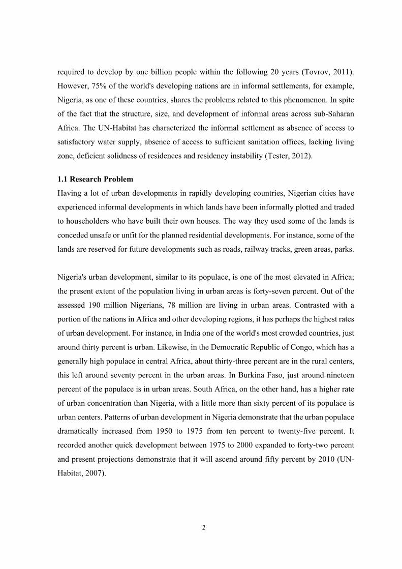
This process was repeated in the most important cities of Nigeria. Kano is one of these cities.
Kano however the center of commerce during that period has rapidly expanded in trade and
other economic opportunities. This has resulted in high migrants’ that have grown the
population and the city of Kano itself. The population of Kano has increased tremendously
causing an expansion in demand for housing in urban areas. See Figure 1.2.
Figure 1.2: Formal and informal differences Kano city (Google map; modified by author)
The expression of “informal settlement” is a more recent western-initiated growth, which
especially came instantly after the Habitat Conference of 1976 in Vancouver, Canada. Slums
are effectively shaped in regions encountering quick urbanization without an equivalent
increment in the arrangement and support of housing and foundation. Slums have been
conceptualized as a group of structures or a territory considered by congestion, disinter-
gration, unsanitary conditions, or nonattendance of fundamental and basic offices like consu-
mable water, waste management, schools, wellbeing offices, recreational grounds, post
office, among others (George, 1999).
5
According to Habitat (2005) it is not only the poor and low-class that lives in informal
settlements, additionally some modest and middle-income families can't achieve access to
moderate housing. On the other hand, informal areas are rapidly expanding in the cities
without the increase in maintenance and allocating in housing and infrastructure. Slums
create suddenly and are sometimes, an immediate aftereffect of the prevalence of poverty
experienced by the inhabitants of cities, which are viewed as a component of urban rot,
additionally result from a clog in overcrowded urban areas where poor immigrants try to
settle for any accessible settlement regardless of value (Olanrewaju, 2004).
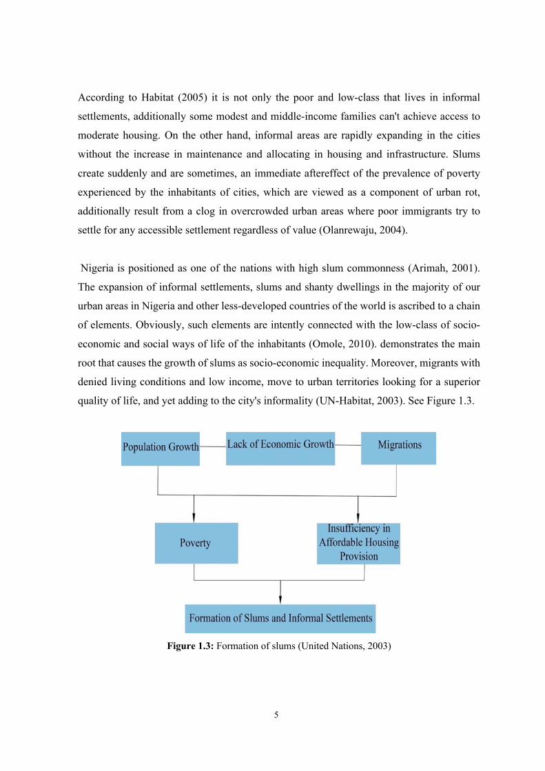
Nigeria is positioned as one of the nations with high slum commonness (Arimah, 2001).
The expansion of informal settlements, slums and shanty dwellings in the majority of our
urban areas in Nigeria and other less-developed countries of the world is ascribed to a chain
of elements. Obviously, such elements are intently connected with the low-class of socio-
economic and social ways of life of the inhabitants (Omole, 2010). demonstrates the main
root that causes the growth of slums as socio-economic inequality. Moreover, migrants with
denied living conditions and low income, move to urban territories looking for a superior
quality of life, and yet adding to the city's informality (UN-Habitat, 2003). See Figure 1.3.
Figure 1.3: Formation of slums (United Nations, 2003)
6
Different important studies about the above realities described must be highlighted. In order
to improve the life of the people living in informal settlements is to investigate, understand
the problems and solutions that has been done in previous studies. In Lagos Nigeria for
instance with a population of 21 million inhabitants, it is the most populated and urbanized
state in the country, which is about 13 percent of the entire population of the country.
However, Lagos has the higher slum areas with over 16 million inhabitants living in such an
area. It needs legitimate drainage and trash accumulation frameworks, so the human and
vegetable squander are passed straight into the harsh waters of the lagoon. A few toilets and
bathroom facilities were developed for the community, the supervision of them was given
to a portion of the young people who took an interest effectively all through the task. They
usually charge for utilization of the toilets and restrooms, a level of which they pay into the
Clean-up Nigeria Waste Management Co-Employable Thrift and Credit Society (Afrol,
2003).
In 2001 a project was created by the World Bank named “Trunk Infrastructure Delivery” in
Makoko Lagos that comprehensive urban renewal programmed covering over 750 hectares
which include nine communities was propelled in the state. Makoko is one of the blighted
communities. The project of $200 million assisted by the World Bank and supervised by the
state government organization Lagos Metropolitan Development and Governance Project
(LMDGP). The extent of the project incorporates squander executives, consumable water
supply, drainage services, street development, and restoration and institutional assist
(George, 2010).
Furthermore, a project was assisted by the World Bank in Oyo State in 1998, a collaborative
project was done by the Ibadan Metropolitan Planning Authority and the Ministry of Lands
and Housing. The state chose to leave on the urban regeneration of Ibadan with significant
concentration to improve different parts of housing, living and environmental states of
various slum regions in the state. The physical arrangement comprised mostly of providing
street lights, public toilets, tarred streets, drainage.
7
Kano, on the other hand, is facing uncontrolled urban growth in some areas like Dorayi with
lack of housing sanitation, public health, water sources and maintenance, vitality supplies,
transportation, social welfare, recreational offices, etc.
Regarding Kano metropolitan area, this thesis will continue with the overall summary of
informal settlements both nationally and internationally, to comprehend the extent to which
urban populations have grown and the subsequent rise in the present number of informal
settlements in the cities.
1.2 Research Objectives
Research Aim: No specific research has been done proposing solutions for the current
informal development in Dorayi Kano metropolitan until now. Therefore, the main aim of
this research is to study the factors influencing the development of informal settlements,
within the case of Dorayi in Kano metropolitan. For the accomplishment of the research aim,
the following points will be considered:
§ To undertake a short review of the place of slums in the development of cities.
§ To reflect on the concept of housing, and housing environments.
§ To evaluate the social, economic and political factors that contributed to the informal
settlement.
§ To find out the best economical and traditional sustainable solution that can help in
solving the problem created by the informal development in Kano.
Research Questions: This research intends to answer the following questions in order to
fulfill the research aim.
§ What are the main characteristics of informal settlements in an international
perspective?
§ How informal settlement developments are affecting the urban shape of the city and
what are the relations among its inhabitants?
§ What are the main factors that influence the quality of the informal settlements?
8
§ How informal settlement development can be analysed for Dorayi in Kano as a case
study?
1.3 Hypothesis
Alongside of the thesis process different argument and proposals will contribute to archive
the main goal, as well as to confirm that the previous topics were defined. I propose this
hypothesis of the thesis: To improve the quality of life in informal areas need to be supported
by a collaborative action of the affected social groups and by the improvement of services
and public spaces.
One of the exercises gained from fruitful past encounters is that slum improvement plans
don't work if people are relocated and lose their source of income and social communities
(Chowdhury, 2006). However, most of the significant aspects to be particularly focused on
involve as follow:
i) To increase more opportunities to generate income, which legitimately improves the
way of life of the individuals and impacts the cost-recuperation of a redesigning
project.
ii) To improve access to health care, which increases the quality of life and production.
iii) To improve access to schools, which education also increases the quality of life and
give more job opportunities to a very high degree.
iv) To construct roads, sewage facilities and commercial centers and improvements of
the accessibility, sanitation and maintenance of the inhabitants.
1.4 Methodology
The methodology of this study is based on a qualitative method. The data evaluation was
collected through literature review of existing books, articles, journals, newspapers,
published and unpublished papers, which consist of photographs, map analysis and reports.
Resources consulted in this study are mainly reports of international experiences. At the
same time, the research concentrated on analyzing the success factors of other experiences
in developing countries to find out opportunities to apply in the measures taken by other
urban areas in Nigeria.
9
As a case study, the research concentrates on the metropolitan area of Kano, which is the
center of commerce in federal republic of Nigeria and tries to analyze the informal settlement
by looking at one of the suburban areas called Dorayi to comprehend the phenomenon of
informal settlements and to examine the challenges of informal areas.
The studies done till today refer to different analysis and perspectives of the informal issue
in Nigeria and Kano. None of them propose such kind of solutions to improve the quality of
life and the inclusion of these areas into the formal urbanization of the city. This is an
important gap, which justified the proposal to be present in this thesis, principles, and
procedures for an effective and successful informal upgrading developments gained from
international experience. These principles should be considered as the essential ideologies
for the project and achievement of the upgrading programs in Kano. Implementing such
ideologies are guaranteed a successful upgrading process.
1.5 Expected Results of the Research
The study expects to get a guideline proposal to improve the quality of life and urban shape
of the metropolitan area of Kano, as a paradigm to be applied in other scenarios, through a
necessary adaptation. The basic issue that should be tended to, is the degree to which the
government can plan advancement strategies that can definitely affect patterns of urban
development.
The thesis will continue to examine the relationship between formal and informal settlements
also with the help of the previous practices and policies used over the years to manage the
informal settlements on the African continent. On the other hand, the study will continue to
discuss some relevant literature on informal settlements in Nigeria. Alongside the review, it
will then focus to Kano, to overview the state informal settlements, structure, and systems,
to provide a brief historical overview of the city background and arrangements.
Therefore, the study will pay particular attention to the various studies that influence the
growth of the informal settlement in order to analyze the growth that play in the existence
of informal settlements, unemployment, poverty and industrialization.
10
Within this scope, Chapter 2 contains a general evaluation of informal settlements including
urban typologies of informal settlements and evolution of informal settlements in Nigeria.
Chapter 3 displays several cases such as Rio de Janeiro in Brazil and Nairobi in Kenya as
international samples. This chapter also includes upgrading projects in China and Africa etc.
Later Chapter 4 has a focus on informal settlements in Kano, Nigeria. This chapter also
contains a case study for Dorayi in particular with the findings.
At the end, as Chapter 5, the thesis presents a practical guideline as proposal where the
collaborative project is an essential tool to archive the most comprehensive solutions for the
upgrading of informal areas. This guideline can be applied to other cases with the help of
needed adaptation to the context.
11
CHAPTER 2
AN EVALUATION OF INFORMAL SETTLEMENTS
2.1 Housing and Urban Environments in Contemporary Cities
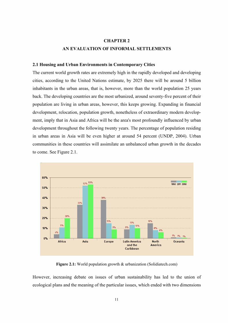
The current world growth rates are extremely high in the rapidly developed and developing
cities, according to the United Nations estimate, by 2025 there will be around 5 billion
inhabitants in the urban areas, that is, however, more than the world population 25 years
back. The developing countries are the most urbanized, around seventy-five percent of their
population are living in urban areas, however, this keeps growing. Expanding in financial
development, relocation, population growth, nonetheless of extraordinary modern develop-
ment, imply that in Asia and Africa will be the area's most profoundly influenced by urban
development throughout the following twenty years. The percentage of population residing
in urban areas in Asia will be even higher at around 54 percent (UNDP, 2004). Urban
communities in these countries will assimilate an unbalanced urban growth in the decades
to come. See Figure 2.1.
Figure 2.1: World population growth & urbanization (Solidiatech.com)
However, increasing debate on issues of urban sustainability has led to the union of
ecological plans and the meaning of the particular issues, which ended with two dimensions
12
arrangements. The first includes green plan issues involving the concerns of numerous in the
developed countries, for example, deforestation, global warming, ozone-layer consumption,
loss of biodiversity and the exhaustion of non-renewable resources. On the other hand, the
developing countries, in any case, these global environmental issues are less prompt than the
need to determine the issues relating to poverty and the issues of air and water pollution,
inadequate housing conditions, poor waste management, lack of basic services and green
areas, nonetheless, the issues of health, crime, violence, and social exclusion.
Improving housing efficiency and environments is a success and basic distraction on the
development of urban areas. The procedure of housing and environmental developments
should be built on sustainability standards, which could be applied in the developments of
building structures. The objectives of the procedure are to diminish the environmental
expenses caused by insufficient valuable systems and arrangements, limiting the effects on
regular assets, and improving punters comfort (Amado et al., 2007).
In the developing countries, similar to Nigeria, urbanization has improved faster than the
capacity of governments to give satisfactory asylum and fundamental comforts for the low-
income, which resulted in development of slums and informal areas. A considerable lot of
the families are resort building with a wide range of materials in illicitly land. Slums are
described by obsolescing resulting from the mutual impacts of such circumstances as
environmental maturing of structures, absence of support and disregard, wrong utilization of
structures, wrong improvement of land, lack of sanitation, transfer of sewage and strong
squanders, and expanding decay of the environmental land (Omole, 2010).
Filani (1987) has briefly demonstrated that most urban centers in Nigeria are described by
high-density structures, the swarming of large quantities of people into those structures, the
absence of room for air living between buildings, in this unsatisfactory environment, and
sanitary issues. The absence of moderate and reasonable housing for the urban poor is thus
a significant issue in Nigeria. Lack of affordable housing in large urban centers show high
numbers of people living in a room. This physical congestion, which is a determinant of two
significant kinds of issues to be specified, health risk and hurtful social conduct (Loring,
1956; Schorr, 1964; Bernstein, 1968; Stokoiks et al., 1973). Irresistible (water-borne and air)
13
sicknesses increase extremely quick beneath such environments (Odongo, 1979).
Nonetheless, various factors more significant than congestion, the spread of diseases,
therefore, it can't solely be taken as a deciding factor. However, it is considered to lead to
irritation, weariness, and ineffectiveness. It is even seen to tend to impede the improvement
of kids' correspondence capacities.
2.1.1 The issue of informal settlements
The informal settlements issue has turned out to be determined in numerous urban
communities everywhere in the world, this, however, had driven researchers attempt to
discover the cause of this issue and solutions to the problem. For instance, one of the most
famous scholar John Turner adopted the notion of self-help housing. He accepted that the
informal residents had the privilege to redesign their homes dependent on their needs
(Runkel, 2009). However, he contended that the residents can develop their own lives by
redesigning and developing their houses. Furthermore, the scholar clarifies that this
procedure will prompt individuals to focus on improvement and urban poor's self-
sufficiency. He additionally included that the dwellers may include all components that fit
their needs and life circumstances according to their assets. Turner's Self-help approach was
analyzed by pundits contending that it kept up the state of affairs and didn't challenge the
wellsprings of disparities and unfairness (Frediani, 2009).
Another scholar named Nakamura who pushed that slum redesigning was secure land
residency since there was a strong relationship between the security of residency and housing
development (Gelder, 2007). Nakamura accepted that there was always dread and battle on
the residents in trusting their poor investment in their houses that led to the probability of
eviction. He additionally explains that people would be bound to put resources into
construction development and expect more future benefits only if they felt more secure in
their houses. He included that attractive physical properties, for instance, the size, design,
conveniences, and obviously foundation, would encourage informal residents to invest
resources into development (Mukhija, 2002).
One of the principle concerns of the United Nations is confronting the genuine test of slums
and addressing the necessities of slum dwellers to access the essential urban services (UN-
14
Habitat, 2003). However, as indicated by the UN-Habitat, slum dwellers are essentially a set
of individuals who need at least one of the accompanying:
§ Access to pure clean water
§ Appropriate shelter of a perpetual nature capable of protecting from climate changes
§ Adequate-living area in terms of space
§ Access to appropriate sanitation
§ Security of residency
The vast majority of the basic characteristics of informal areas involve: they are constructed
without appropriate proficient help, built for the bigger part by the tenants for whom
accessible conventional roads are not really practical alternatives; built with nearby building
materials, skills, designs, technology and don't stick to formal/legal construction regulations
and guidelines (Fekade, 2000).
Throughout the following four decades ‘developing countries’ urban areas will ingest
ninety-five percent of the world's urban populace development (UN-Habitat, 2008). In urban
communities where, informal expansion is the standard as opposed to the special case, this
implies ‘urban development will turn out to be for all intents and purposes synonymous with
slum arrangement in certain districts’ (UN-Habitat, 2006). However, the developing and
spread of informal areas, enormous housing in urban areas, middle and low-income in the
countries, is nothing less than the ‘physical and spatial indication of urban poverty and intra-
city imbalance’ (UN-Habitat, 2003).
Slums and informal settlements are caused by a scope of solid components, containing
population growth and migration, absence of moderate housing, feeble administration
(especially in the regions of strategy, development and urban administration bringing about
property theory), financial vulnerability and underpaid work, marginalization and relocation
brought about by struggle, natural disasters (UN-Habitat, 2013).
15
2.2 Theoretical Framework for Informal Settlements
Slums are commonly portrayed as “intensely populated urban regions, described by
insufficient housing and messiness” (UN-Habitat, 2013). The idea of a slum was first
presented in London in the mid-1800s when the regular workers of England started moving
simultaneously to the city and living in alternative houses production lines where they
worked. This idea didn't quicken quickly until the twentieth century when the expansion of
many developing countries in Africa and South-East Asia happened (Shankardass, 2006). It
is estimated 2007 according to the UN the greater part of the total populace lives in the city.
Because of the continuous urbanization and development of the total populace, there will be
about 2.7 billion additional dwellers to the urban populace by 2050, mostly in Asia and
Africa. The inner-city population is ascending among the sub-Sahara African nations; as of
now, somewhere in the range of seventy-six and ninety-six percent of urban inhabitants in
numerous African urban communities live in unsanitary slums of flimsy housing (Kissick,
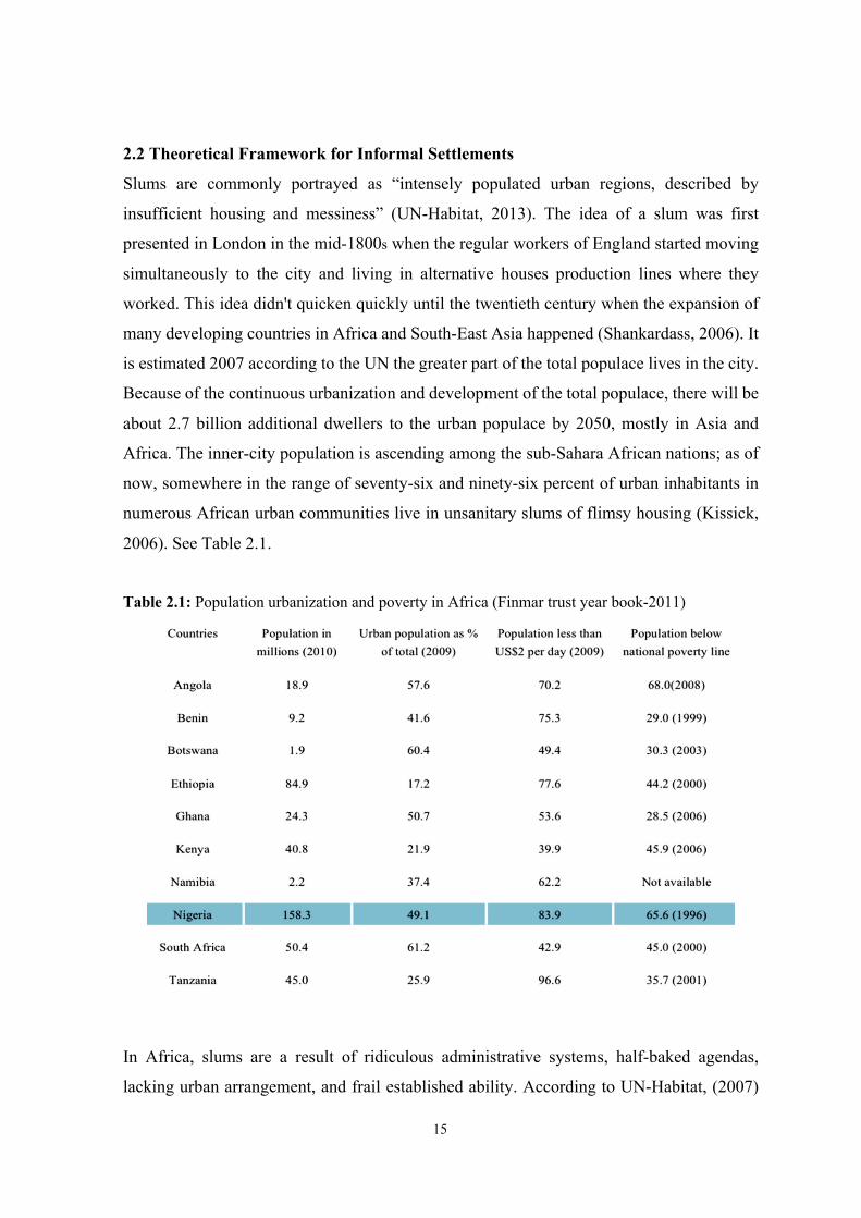
2006). See Table 2.1.
Table 2.1: Population urbanization and poverty in Africa (Finmar trust year book-2011)
In Africa, slums are a result of ridiculous administrative systems, half-baked agendas,
lacking urban arrangement, and frail established ability. According to UN-Habitat, (2007)
16
different variables incorporate, hasty rural to urban relocations, expanding urban dearth and
imbalance, uncertain residency, and globalization. Slums are likewise originated to emerge
from unsuccessful strategies, poor administration, defilement, improper guideline, and land
markets, poor economic methods, and the most important absence of a diplomatic will.
However, there is a connection amongst urbanization and slum arrangement in most
emerging nations. As opposed to these aims, particularly the Structural Adjustment Program
(SAP) has existed unequivocally arraigned (Davis, 2006). Which the main studies of SAP
contend: “the essential course of both national and international intercessions during the
most recent 20 years has really expanded urban destitution and slums, expanded prohibition
and inequality, and debilitated urban elites in their endeavors to utilize urban areas as
motivation of development” expounding on the growth of urbanization in developing
nations. Venard (1995) surmises that Africa by 2020 will develop super urban communities
with over 4.5 million residents or more. This quick development in the urban populace would
prompt fast development equally in the size and number of urban areas.
Slums are developing, all measurements are pointing towards that the expanded growth is
making huge slums everywhere in the developing world (Habitat, 2005). Davis (2006) it
shows the slums of Asia, Africa or the Middle East “in this case because of the refugees” as
the urban communities of tomorrow, where a large number of people will live in the years
to come.
In view of population density, extent of apartments, the quantity of people per house unit and housing conditions in informal settlements can be partitioned into four primary classifications: i) The affluent settlements have the most elevated housing principles: unsatisfactory housing comprises under 15% of the residence stock, swarming rate is under three people for every home unit and about 40% of the texture of these settlements is made of multi-story buildings; ii) The moderate settlements: have less housing quality, density and utilization is like the abovementioned and apartment buildings make up under 20% of the settlements private structures; iii) The disadvantaged of this settlements: inferior quality of housing, in excess of 33% of the stock is little and inadequate, occupants are packed more than four of every a home and building stock contains under 20% apartment buildings (Fekade, 2000); and iv) slums: the most exceedingly terrible type of informal settlements, described by all-out absence of fundamental administrations (Habitat, 2007).
17
Abdul Sattar Hatita a journalist from Egypt northeast Africa who has writing deferent papers
about slums, he addresses another depiction of slums is that: “Slums are ignored pieces of
urban areas where housing and living conditions are shockingly poor” (Hatita, 2014) The
basic meaning of ‘slum’ recommends that it is: “...a touching settlement where the residents
are portrayed as having incompetent housing and fundamental services” (Steering
Committee on Urbanization, 2011). A slum is frequently dismissed by the public authorities
and not thought about an equivalent piece of the city (Khalifa, 2011).
Characteristics of informal settlements
To understand the phenomenon of informal areas according to (Rapoport, 1988) it is
imperative to take note of that in the broad writing on slums, regularly the emphasis is on
how these settlements are made “the procedure” as opposed to the qualities that outcome
from their developed surroundings, “the result”. According to Rapoport, (1988) the natural
characteristics of slums: “Unconstrained settlements, similar to every single human
condition, don't simply occur; they are planned as in intentional changes are made to the
physical condition through a progression of decisions among the accessible options”.
One of the characteristics of informal settlements is an absence of land residency or not
registered property and substance to non-formal residency rules, which the occupants don't
have proprietorship record, for example, legitimate deeds to demonstrate their responsibility
for the property. However according to the (UN-Habitat, 2003; Payne and Majale, 2004;
Tsenkova, 2010), unsure residency status (houses normally built on lands with an
unexpected status in comparison to that of the tenants); collective or fractional infringement
of structure grants; absence of fundamental administrations (absence of access to the
principle urban foundation); unacceptable houses, unlawful or wrong building structures;
settlements discontinuity; low quality development materials (timber system, clay blocks,
materials reused from demolitions and so on); over-crowding; inhabitants influenced by
destitution and social exclusion; hazardously living conditions, risky to the health of the
resident.
For the vast majority of the informal areas, the legitimate status of the land is questionable
or unlawful and the legal status of the structure relies on that of the land. During the post-
18
socialist period, the advancement of new local locations through the urban spread and the
solid decrease of experts for those open foundations in responsibility with the control of
building principles created a phenomenal development of illicitly fabricated houses inside
or outside the areas developed zone (Suditu, 2012).
There are two unique circumstances relying upon the responsibility for informal settlements
land. At the point when there is no legal right on the grounds the houses are based, the
inhabitants belong to the classification of powerless community or ethnical units. The
community blend created by the communist procedure of constrained development
prompted their post-communist "enclavization".
In the past ten years (2000/2010), the urban population living in informal areas has decreased
in from 40 percent to 30 percent (UN-Habitat, 2011). Nonetheless, the MDG and UN report
gauge that somewhere in the range of 2000/2010, a sum of 230 million slums residents in
developing nations accomplished noteworthy enhancements in their living circumstances, in
this way inferring Target 11 of Millennium Development Goal 7 has been surpassed by
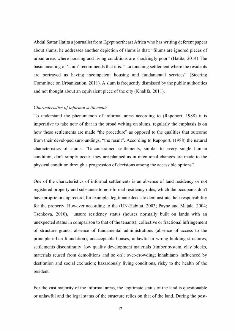
twofold (UN-Habitat, 2013). See Figure 2.2.
Figure 2.2: Drone photo of Mumbai reveals the places where extreme poverty meets extreme
wealth (businessinsider.in)

19
Arrangement and involuntary reactions by national and state authorities, international
growth collaborators, NGOs and community-based, associations have also improved the
living states of informal residents. For instance, the institution of dynamic and
implementable urban upgrading, affordable housing, informal improvement, and land
strategies has given significant drive force to respond to such area, for example, direct
foundation arrangement, poor financing choices and imaginative associations for reasonable
housing arrangements, informal settlements regularization, and slum redesigning
programmers. In spite of these increases, one-fourth of the world's city populace keeps on
living in shantytowns. Meanwhile, in 1990, over 200 million slum inhabitants have been
added to the world population (UN-Habitat, 2013).
In Africa, over a portion of the urban populace, lives in informal areas and by 2050, Africa's
urban tenants are anticipated to expanded from 370 million to 2 billion (UN-Habitat, 2013).
In Asia, 35 percent of the urban populace lives in informal areas. However, Asia was at the
bleeding edge of effective endeavors to arrive at the MDG Target 11 Goal 7, with authorities
improving the lives of an expected 170 million slum occupants (UN-Habitat, 2013). In the
Arabian region, the extent of improper housing fluctuates from nation to nation. In certain
nations, slums and informal residences structure are separated, however in others from 70
percent to 90 percent of urban inhabitants living under at any rate of housing. In some Gulf
nations, for example, housing situations of low-class migrant employees are often poor
contrasted to the rest of the urban population (UN-Habitat, 2012).
The capacity of informal tenants to move out of these ruined circumstances remains
constrained. For instance, additional 10 million dwellers to the urban populace in Africa
consistently, 66% (7 million) live in slums or informal areas and just 2 million can hope to
move out from that point (UN-Habitat, 2011). There is an association concerning the
development of informal areas, the absence of sufficient land and satisfactory housing.
However, the private segment investing into housing has been relentless throughout the
years, this venture has not converted reasonable housing. A few examinations propose that
moderate housing presently remains at six thousand five hundred dollars per year, is required
to develop (McKinsey, 2014).
20
2.3 Urban Typologies of Informal Settlements
Urban housing may thoroughly be organized into formal and informal settlements. Formal
areas are those which have been constructed and made by the administration offices or
housing social orders on suitably endorsed plans. Other than social, physical, and economic
and various examinations are considered for the improvement of such settlements with the
goal that living conditions become suitable and friendly to the inhabitants.
On the other hand, informal areas are those which have to originate illicitly moreover on the
government land or private land in an irregular way. Nonetheless, are spontaneous and
abusing all standards of government projection. Edging the city drains, railroad tracks and
besides possessing farming area and green belts in and around the city. Lacking potable
water, sanitation, garbage disposal, regular power supply, street organize, parks, green areas
and so forth. Leaving in poor houses with deficient light, air, toilet, and bathroom;
congestion and high density of population are a portion of the highlights of these informal
settlements (Aliyu, 2006; Bose, 1995). According to the Center for Urban and Regional
Excellence, 2005 these settlements have come up one unlawful, the vast majority of them
need fundamental amenities as well as legitimate privileges of the inhabitance despite the
fact that some of them may have been in presence for quite a while.
Appeared differently in relation to other urban occupants, residents of informal areas,
especially in slums, bear progressively spatial, financial and social prohibition from the
advantages and chances of the more extensive urban condition. They know-how steady
separation and an outrageous detriment portrayed by geological underestimation, essential
administration shortfalls, poor administration structures, constrained access to land and
property, shaky vocations, because of informal area, high powerlessness to the unfriendly
effects of poor and uncovered situations, environmental change and cataclysmic events.
The development of slums has significant outcomes on both nature and humans. The
situations that happen in informal areas, for instance, living under risk from physical and
natural fiascos and inappropriate housing have directly affected their inhabitants. The slum
occupants, however, can affect their environment because of the absence of basic facilities
and infrastructure which effects defiled land and contaminated air and conduits. These
21
outcomes in a propagated rotation of decay for both informal inhabitants and nature, with
the plausibility of effects stretching out to neighborhoods past the shantytowns (i.e.,
flooding) (Aliyu and Sule, 2006).
Territorial imbalance
The migration between rural to urban has been key for the growth of urban areas, however,
it has been recognized as the number one essential key for the development of informal
areas. In less-developed nations, the present fast and vast net development of the rustic
populace to city areas has increased (Ewers and Malecki, 2007; Srivastava and Singh, 1996).
This is because of a few dynamics relating to the pulling of provincial residents to urban
communities and pushing the population away from rural communities. Lacking necessary
amenities, for example, schools and medicinal services inside urban communities for
instance (Khan et al., 2014), or the opportunity from prohibitive cultural or social standards
frequently found in rustic territories for instance, such occasions have driven rustic tenants
to urban territories, there has been an absence of monetary development in a large number
of these nations, however, when it merged it become slums development and determination,
particularly in African nations (Fox, 2012; Opeyemi et al., 2012; Ullah, 2004).
Hyper concentration of population
In addition, ‘urbanization of destitution’ or poverty is moving to urban communities the
governments should make a substantial move pioneering the trail to a gigantic increment in
the number of slum inhabitants around the world (Arnott, 2009). Right around 32 percent of
the world's urban population (around 1 billion people) live in a slum and most of them in the
developing world (UN-Habitat, 2003). Since that time policy was created by the world
organization concerning tenants and informal areas, additionally the accompanying
approach occurred; The Right to Housing and Universal Declaration of Human Rights on
UN Charter, the Standards of a Slum Household on UN-Habitat, Agenda 21, Chapter 7 and
the Millennium Development Goals, Goal 7/Target 11 (UN-Habitat, 2006). The World
Urban Forum founded by the UN in 2001 credited an agenda “Cities without Slums”
utilizing the term slum to depict “a wide scope of low-income residents or potentially poor
human living conditions” (City Alliance, City without Slums,, 2016).
22
Throughout the most recent couple of years, there has been an upsurge of notice for the
feasible effect of environmental change on populace developments. In spite of the absence
of exact figures, there is currently little uncertainty that parts of the earth are winding up less
habitable because of elements, for instance, environmental change, weakening of
agricultural lands, desertification, and water contamination. The quantity of natural disasters
has dramatically increased in the course of the most recent two decades, and in excess of 20
million people were uprooted by abrupt beginning atmosphere related natural disasters in
2008 (OCHA-IDMC, 2009). The movement of people as a result of changes in the
environment is not a new phenomenon. Dwellers have been moving because of changes in
their environment, regularly for quite a long time. For nomadic dwellers and pastoralists,
such movement is a piece of their living. However, it is just over the most recent 20 years or
with the goal that the global community has started to gradually perceive the more extensive
linkages and suggestions that a changing atmosphere and environment has on human
mobility. According to the International Organization for Migration (IOM, 1992).
“Enormous quantities of dwellers are moving because of ecological corruption that has expanded significantly in recent years. The number of such migrants could rise considerably as bigger regions of the earth become appalling because of climate change.”
2.4 Weak Planning and Management of Cities
The support of structures and infrastructure is common in Nigeria. However, lack of
maintenance, buildings structures, and public utilities could be a significant issue that adds
to slum development. High framework cost and inflexible structural standards have
prompted a moderate pace of growth, which brought about unreasonably expensive housing
for some huge portions of the population (Mayo and Angel, 1993). In Nigeria, official
expenses engaged with the enlistment procedure to secure plot can be as much as 30 percent
of the house estimation, exhibiting a test for slum tenants with restricted funds. These
conditions, at last, indicate excessive paces of insecurity of residency and give favorable
settings that keep on driving the development of informal areas because of ineffectively
operative plot sells.
Additional issue in several developing nations is the disappointment of governments to fuse
informal tenants as a segment of the general development procedure. This is regularly
23
because of the incapability of numerous governments to stay up to date with urbanization
due to the absence of resources and degenerate governments (Fekade, 2000). A few
governments additionally decline to give urban administrations to informal tenants in dread
that this will just heighten the phenomenon of this area or lead to increasingly settled
property privileges, which several administrations are reluctant to give (Fox, 2012; Opeyemi
et al., 2012). As talked about by Herbert (1999), without increasingly recognized the
privileges for informal tenants, administrations cannot have the capacity to power such
occupants into sustenance for public facilities and upgrading their houses. Nonetheless, it’s
additionally the situation that a few administrations do not have the constitutional
determination to address these issues. However, with the lack of sufficient attention that has
been given to the informal residents, this has given more sanctioning to the continuing
growth of slums.
Social costs of informal development
The procedures that add to the geographical relegation of specific groups of people view on
where they live and what their identity is. It is portrayed by their inability to access or
adequately utilize an entire scope of abilities and assets which improve prosperity and
position individuals to make the most of accessible opportunities. Specific groups and people
regularly endure a lopsided ‘burden’ because to their personality, which is spoken in urban
settings by the authority of informal settlements (Fincher and Iveson, 2008).
Environmental costs of informal development
The dispersion of slums is affected by the dynamics like the accessibility of government
open land, proximity to the working environment, access to transport services, and so on.
These are a portion of the main considerations answerable for the area of slums. Most of the
slum areas are situated in low-class areas and in areas where the probabilities for the
residents to remain is high without the risk of expulsion. The dynamic connection among
poverty, biological system administrations, and contamination that sees defenseless and poor
urban tenants experience the ill effects of natural effects. The environmental equity targets
checking maltreatment of intensity in association with natural resources and requires the
lawful and community strengthening of low-class people together with better approaches to
deal with supportability to verify ‘future generations’ satisfaction (UN-Habitat, 2014).
24
However, the size and form of urban blocks are likewise significant as it can control the
microclimate and issues of wind and sun entrance and in this way, an equalization must be
struck inside the arranging technique between natural execution and urban structure.
Economic costs of informal development
The housing condition is exceedingly bad for the urban poor, a large number of whom are
constrained to live in dehumanizing conditions. Because of the significant cost of decent
housing, low-class residents are compelled to live in self-made buildings in slums and
informal settlements. Moreover, slums influence the thriving of urban communities and their
maintenance. While from one perspective these territories are recognized as giving truly
necessary blended plot use to urban communities and as having a functioning informal
economy (UN-Habitat, 2008).
Poverty
The greater part of the governments and international agencies underestimated the scale of
poverty, which is typically reflected in the informal territories of those urban communities.
Slum can be classified as two-directional connections among deterioration of the
environment and poverty, lack of plan, waste disposal systems, and poor drainage which are
regular structures in numerous streets in Nigeria.
There are a few factors that add to the excitement of slums, more specifically in Nigeria.
According to OMOLE 2010:
The high pace of poverty and the absence of education has been recognized as variables that contribute essentially to the development of slums in Nigeria. Slum regions are the locus of destitution where different variables that upgrade slums and development are perceptible (Omole, 2010).
Low-pay influence the degree of capital development, which denies the individuals of
adequate assets to use in improving their homes and keep their condition solid for happy
living.
25
Buildings are meant to stand long but are different when it comes to slum areas due to lack
of maintenance and standard building materials this causes rapid deterioration of houses and
infrastructure also have tremendous support in the growth of slum.
2.5 Evolution of Informal Settlements in Nigeria
In taking a gander at the planning and the board of Nigerian urban centers over the most
recent 50 years, there are a few dynamics that add to the dominance of slums in Nigeria.
They have been shaped by experiences of oil-boom in the late 1960s to mid 1970s, the Civil
War of 1967 to 1970, the monetary downturn of the 1980s and 1990s, cash crops-based
economy and the chaperon financial changes, political crisis of 1992 to 1998 and
comparative expansion in revenue and political stability of the early 2000 to 2010 which
permitted progressively loosened up deduction and positive activities. Nonetheless, Nigeria
is a country with large historic urban areas that has consistently been a piece of the country.
In those periods before the arrival of British colonial masters into the Nigeria soil, countless
urban areas had developed on the landscape, i.e. Bauchi, Kano, Katsina, Sokoto and Zaria
in the northern part. Abeokuta, Ibadan, Ilorin, Ijebu-Ode, Iseyin, Shaki and Ogbomoso in
the west and the south (coastal) area i.e. Benin, Calabar, Opobo and Warri. According to
Mabogunje 1990, it is estimated Sokoto had around 100,000 citizens when it turned into the
religious capital of Uthman Dan Fodio’s Muslim caliphate, Kano had around 25,000 and
Kaduna’s populace was put at somewhere in the range of 38,000 to 60,000. Nonetheless, the
number of inhabitants of Ibadan to be somewhere in the range 80,000 to 120,000, Abeokuta
about 50,000 and Oyo 30,000 (Flanagan, 1979). According to Venard's 1995, the ongoing
improvements in the country is making serious progress, dependent on an evaluation that
was directed in 2006, five states (Kaduna, Kano, Katsina, Lagos, Port-Harcourt, and Oyo)
were recorded with the population over 6 million and 25 recorded a populace of 4 to 6 million
residents.
To approach the issue cities like Abuja and Legos were seen as regular in these slumming
urban communities, for instance:
§ Rising of the population that is expanding the demand for urban facilities.
§ Severe deficiency of housing allocation for the middle and low-class families.
§ Poor urban planning and managing of urban development and extension.
26
The UN-Habitat, (2008) reports that Nigeria’s failure to design and supervise the hasty
urbanization, which brought in strong development in the major urban regions and towns.
The weight of these issues is assumed by the poor people and the low-pay who come up
short on the budgetary ability to get to sufficient housing. An ongoing projection shows that
by 2030 over 75% of Nigerians will live in urban centers and a large amount (generally low-
payed workers and poor people) of these are probably going to live in informal areas if action
is not made (FRN, 2010). The slum condition in Nigeria is as of now alarming for the
explanation that the extent of individuals influenced by informal situations is such a huge
component in Africa. In 2012, the populace estimate was conducted for 47 sub-Sahara
African nations with over 920 million and 170 million were Nigerians (FRN, 2013).
However, 60% were believed to dwell in informal areas. Statistically, 60 percent of 170
million is equivalent to 105 million, from this it may be derived that Nigeria alone has over
a portion of the 190 million informal dwellers in Africa. This circumstance requires a
suitable strategy and reaction by the experts in Nigeria.
The development of informal settlements in Nigeria shadows closely to the general pattern
of its urban development. Each state has its dynamics in informal development. According
to (Arimah, 2001). Nigeria is positioned as one of the countries with high slum dominance.
With over 70% of the residential units in urban areas weakening unsanitary conditions, or
lack of fundamental and basic amenities like consumable water, schools, health amenities,
waste system, post office, parks, and green areas (George, 1999).
This illustrates a direct correlation between economic growth and poverty reduction. Nigeria
with an average of per capita of less than US$200 and to purchase 400 square metres range
between US$4,000 to US$5,000 depending on location, this has classified the majority of
the population that can be poor. In this situation where the cost of a plot is high, no low-
income earner has the capacity to purchase such. The option left for the low income to meet
their housing need is to depend on the informal area where the cost of land is reasonably
affordable.

27
2.6 National Approach for Dealing with Informal Settlements in Nigeria
The urban development process involves in a range of partnership between the governments
in Nigeria and international communities including multilateral and bilateral organizations.
A sustainable project was created in some cities in Nigeria these partnerships with the
Sustainable City Project (SCP) are the Millennium City Project and the NEPAD city project.
The SCP was initiated by the UN-Habitat in partnership with the governments in Nigeria
and the United Nations Environment Programme. It started in Ibadan in 1995 and was
extended to Kano (1996) and Enugu (1997) while in 2003, the city improvement procedure
was initiated in Karu, Nassarawa State Nigeria. The premise of SCP is that ‘for improvement
and accomplishments to be truthfully 'economical', urban communities must discover better
methods for adjusting the requirement for environmental sustainability and the human needs.
Parts of the achievements of these projects are the development of hygienically water and
strategy for waste management including waste recycling and waste-based fertilizer
company in Ibadan. In Kano, the project led to CBOs’ engagement in urban management
and institutional reform. In Enugu, the project led to the Ugbene-Abakpa Erosion control
and the Awkunanano Old Market Improvement Demonstration project. This SCP is
supposed to teach the governments on using partnerships for city development. NEPAD City
Project (NCP) was initiated by the African Union. The NCP is to address the environmental
problems of African cities (Daramola, 2010) and to ensure successful urbanization in order
to achieve the objectives of the organization. The NCP is a partnership between national and
local governments, the government of Belgium, Institute Africaine de Gusion Urbaine,
Dakar, University of Architecture Studies, dares-Salaam and UN-Habitat. The project has
already completed a framework profile for Lagos and set up the committee of NEPAD
mayors to be responsible for NEPAD cities award.
The third major city development project from partnership with international bodies is the
Millennium City Project (MCP). It was initiated in 2006 to help Sub-Sahara African
countries to achieve the MDGs. It formulates Integrated City Development Strategies and
helps the participating cities to focus on promising investments, dealing with infrastructure
necessities and improving the effective conveyance of basic public services (MCI, 2009). In
Nigeria, Akure and Kaduna are taking an interest urban community. The project works in
association with UNIDO, KPMG, Millennium Promise and Colombia University's Business

28
School and School of International and Public Affairs (SIPA). In Akure, the project has
created Akure Investment Initiative and Opportunities Profile while in Kaduna, the State
government has through the project started another city (Millennium City) to oblige an
expected 200,000 people. See Figure 2.3 and 2.4.
Figure 2.3: Construction of 250 units of houses at millennium city, Kaduna (Nurus Siraj Ltd)
Figure 2.4: Kaduna millennium city master plan (Nurus Siraj Ltd)
The figures above shows the construction of 250 mass housing at Danhonu II, Millennium
City, Kaduna by Nurus Siraj Ltd in collaboration with Kaduna State government. This is one
29
of 18 such mass housing projects meant at providing affordable housing for low and
medium-income earners in all parts of the state.
Nevertheless, in Abuja for example, the tenants of informal areas are typically permitted to
get the plot from the nearby individuals who are sitting tight for relocation by the
government, this empowers them to illicitly squat ashore that has belonged to the
government. Starting in early 2005, there were 30 informal zones in various regions of the
Federal Capital Territory (FCT) Abuja and their joined expansion secured a land zone of
2400 square metres (SERAC, 2006). The circumstance in Jos is unique to that of Abuja as
in the occupants of shantytowns regularly secure their territory legitimately from the local
landowners. Nonetheless, the buyers would normally not formalize the deal at the land
offices. Moreover, the buyers regularly embrace improvement on the plot without getting
licenses from the state planning and improvement offices. In early 2005, an aggregate of 30
informal zones was prescribed for regeneration and the state government in Jos reacted by
informing the master plan and structure a key arrangement for its accomplishment (Dung-
Gwom, 2007). However, according to (Alao, 2013: State, 2008) the full-scale usage of the
key arrangement was at this point to initiate starting at 2012 however the legislature was
centered around the development of downtown streets and introducing of new ones: about
ten agreements for such activities were granted in 2008 and 12 other projects were awarded
in 2013.
30
CHAPTER 3
INTERNATIONAL SAMPLES OF INFORMAL SETTLEMENTS
3.1 Rio de Janeiro in Brazil
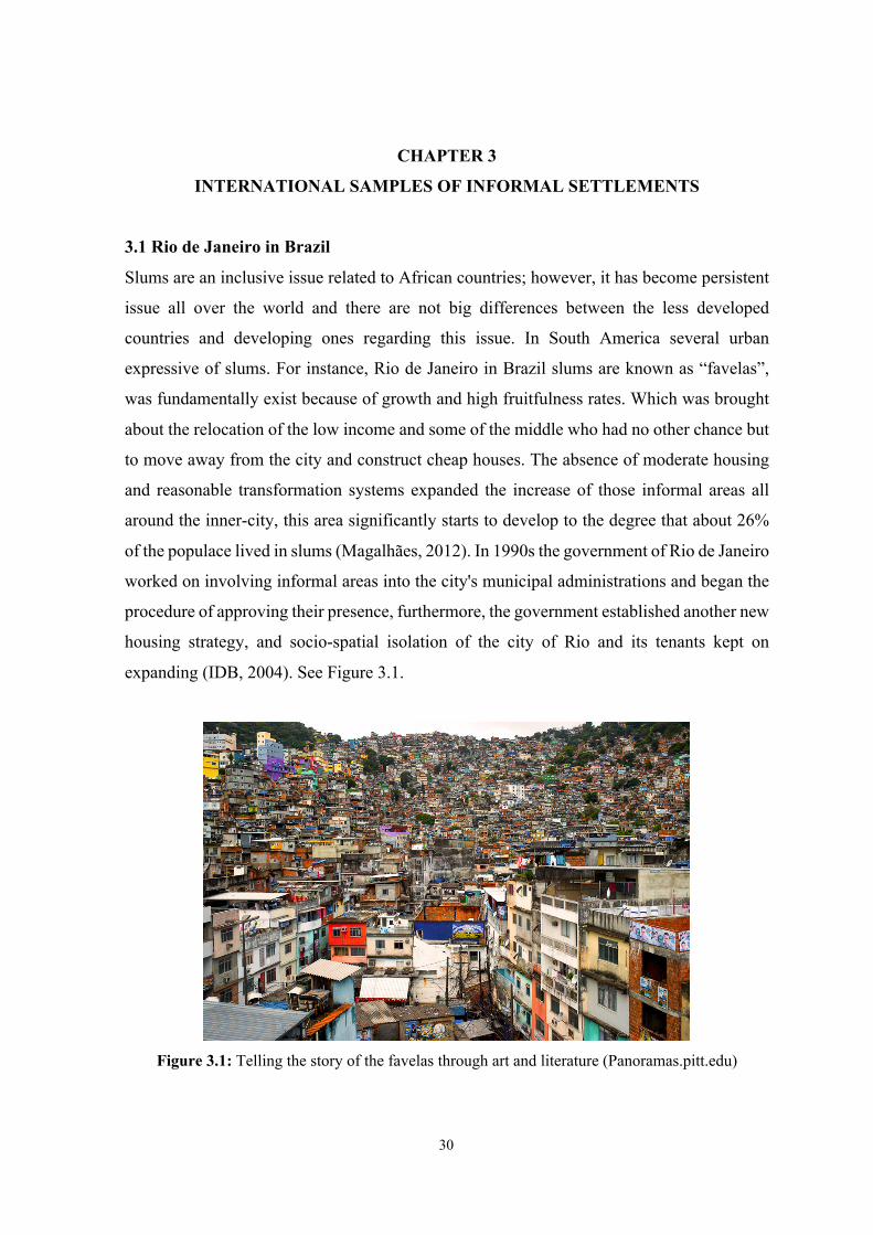
Slums are an inclusive issue related to African countries; however, it has become persistent
issue all over the world and there are not big differences between the less developed
countries and developing ones regarding this issue. In South America several urban
expressive of slums. For instance, Rio de Janeiro in Brazil slums are known as “favelas”,
was fundamentally exist because of growth and high fruitfulness rates. Which was brought
about the relocation of the low income and some of the middle who had no other chance but
to move away from the city and construct cheap houses. The absence of moderate housing
and reasonable transformation systems expanded the increase of those informal areas all
around the inner-city, this area significantly starts to develop to the degree that about 26%
of the populace lived in slums (Magalhães, 2012). In 1990s the government of Rio de Janeiro
worked on involving informal areas into the city's municipal administrations and began the
procedure of approving their presence, furthermore, the government established another new
housing strategy, and socio-spatial isolation of the city of Rio and its tenants kept on
expanding (IDB, 2004). See Figure 3.1.
Figure 3.1: Telling the story of the favelas through art and literature (Panoramas.pitt.edu)
31
Because of the expansion in the informal areas, the government implemented a few critical
informal projects. One of these projects involves the Urbanization Program for Popular
Settlements in Favela Bairro (Castro, 2009). Planned for consolidating shantytowns inside
the city by developing road to essential areas and social administrations.
3.1.1 The Favela Bairro development
A collaboration project was created by the national government and the Inter-American
Development (IDB) with total the sum of $300 million for the project, the main aim of the
development involving water supply, illumination equipment, road surface, and sanitary
systems. The project was fulfilled by the support of the residents and public agencies. A loan
of $120 million was given by the local government of Rio de Janeiro and about $170 million
was given as co-financed from the Inter-American Development (IDB) (Soares, 2005).
In 1994, the Mayor’s office launched the Favela Bairro project along with the funds. 180
million USD was received in December 1995 as an additional loan. This succeeded with
regards to financing a significant expansion of Favela Bairro to achieve over 50 slum
territories. This agenda likewise coordinated essential framework works in eight other
informal areas. The essential substructure parts of the task which included; sanitary systems,
standards of sanitation, water supply, standard electricity, and street asphalt. This structure
was also fulfilled by the support of residents and public agencies.
At the beginning of the project, the Inter-American Development (IDB) managed the policy
and upgrading the informal area was the primary concern. Later on, the conception of the
Municipal Housing Department turned into the head of the program, which created more
programs that included training and community activities daycare centers and members of
the informal area established guidance in issues of community improvement, sanitation in
different places of the project (Fiori, 2000). Moreover, throughout the following period of
the project, more Favelas were chosen and a property designating agenda, which was at first
made arrangements for, began performance (Soares, 2005).
Favela Bairro was focusing on middle-class communities, nonetheless, the populaces with
high development costs were prohibited. The administration likewise carry-out different
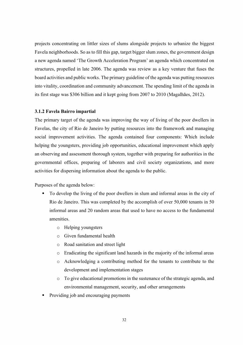
32
projects concentrating on littler sizes of slums alongside projects to urbanize the biggest
Favela neighborhoods. So as to fill this gap, target bigger slum zones, the government design
a new agenda named ‘The Growth Acceleration Program’ an agenda which concentrated on
structures, propelled in late 2006. The agenda was review as a key venture that fuses the
board activities and public works. The primary guideline of the agenda was putting resources
into vitality, coordination and community advancement. The spending limit of the agenda in
its first stage was $306 billion and it kept going from 2007 to 2010 (Magalhães, 2012).
3.1.2 Favela Bairro impartial
The primary target of the agenda was improving the way of living of the poor dwellers in
Favelas, the city of Rio de Janeiro by putting resources into the framework and managing
social improvement activities. The agenda contained four components: Which include
helping the youngsters, providing job opportunities, educational improvement which apply
an observing and assessment thorough system, together with preparing for authorities in the
governmental offices, preparing of laborers and civil society organizations, and more
activities for dispersing information about the agenda to the public.
Purposes of the agenda below:
§ To develop the living of the poor dwellers in slum and informal areas in the city of
Rio de Janeiro. This was completed by the accomplish of over 50,000 tenants in 50
informal areas and 20 random areas that used to have no access to the fundamental
amenities.
o Helping youngsters
o Given fundamental health
o Road sanitation and street light
o Eradicating the significant land hazards in the majority of the informal areas
o Acknowledging a contributing method for the tenants to contribute to the
development and implementation stages
o To give educational promotions in the sustenance of the strategic agenda, and
environmental management, security, and other arrangements
§ Providing job and encouraging payments
33
Table 3.1: Favela Bairro planned and accomplished objectives (Magalhães, 2012)
Planned Objective
Accomplished Objectives
Module 1 (Urban Infrastructure) – Integrated Urbanization
(a) Infrastructure (i) Providing sewage system: (ii) Street paving and illumination: (iii)Geological risks: (iv) Social equipment: (b) Community development (i) Community participation (ii) Providing educational campaigns in support of the planned projects, environmental conservation and protection, maintenance of the sanitary and other infrastructure. (c) Land-titling regularization:
(a) Infrastructure (i) Providing sewage system: (ii) Street paving and illumination: (iii)Geological risks: (iv) Social equipment: (b) Community development (i) Community participation (ii) Providing educational campaigns in support of the planned projects, environmental conservation and protection, maintenance of the sanitary and other infrastructure. (c) Land-titling regularization:
Estimated Cost: US$422 million
Actual Cost: US$424.661 million
Module 2 (Social Action) - Serving Children and Teenagers
(a) Serving children from birth to 4 years old (b) Serving children between 7 to 14 (c) Support for groups in high-risk situations:
(a) Serving children from birth to 4 years old (b) Serving children between 7 to 14 (c) Support for groups in high-risk situations:
Estimated Cost: US$25.5 million
Actual Cost: US$19.231 million
Module 3 - Providing Employment Opportunities
(a) Specialized training (b) Increasing educational services:
(a) Specialized training (b) Increasing educational services
Estimated Cost: US$9 million
Actual Cost: US$9.476 million
Module 4 – Institutional Development
(a) Monitoring and evaluation: (b) Technical assistance (c) Social communication:
(a) Monitoring and evaluation: (b) Technical assistance (c) Social communication:
Estimated Cost: US$4.5 million
Actual Cost: US$5.19 million

34
3.1.3 Favela’s project
The greater part of the work was accomplished throughout the first period of the program.
95% of accomplishments, 280 community works and different developments, were fulfilled
in the objective of the Favela’s program. Mediations were made in 40 of them focused on,
over 50 in favela. Three primary yields were inside the structure of the projects: water access
incorporating association with sewers, cleared roads and founding of nurseries. An
investigation by revenue uncovered that the territories with the most unfortunate populace
profited by access to consumable water, clean and trash gathering, though the regions with
more populaces did to a lesser degree (Soares, 2005). See Figure 3.2.
Figure 3.2: Favela Bairro project; Developing solutions Rio de Janeiro, Brazil1 (weebly.com)
Table 3.2 below shows the level of satisfaction concerning principle upgrades in services for
the informal territories which were fulfilled by the Favela’s agenda and those which were
not fulfilled by the agenda:
Table 3.2: Satisfaction with main services: Comparison: Areas served by Favela Bairro and others
not served by the program (Tulier, 2011)
Sewage Garbage
Collection
Public
Lighting
Drainage Street
Network
Favela Bairro 85% 90% 75% 75% 85%
Not served by the
program
40% 35% 35% 22% 12%
35
3.2 Nairobi in Kenya
In Kenya, the eastern coast of Africa the city of Nairobi has another good example of slum
upgrading. In the same way, like other developing nations, Kenya has seen a colossal
increment in city populace in the past recent years. An important percentage of the urban
dweller are living in informal areas. That lacks most of the fundamental infrastructure to
maintain a minimum standard of living, lack of good services of housing, health and
education. According to Syrjänen (2008) in Nairobi, for example, the develop-ment of
ghettos was phenomenal; about 58% of the populace, occupied 5% of the over-all land
territory and dwelt in a slum. Moreover, water was not accessible with the except of just
20% of the informal populace in Nairobi, a large portion of them experienced the significant
expenses forced on them by manipulative sellers (UN-Habitat, 2006). These areas, however,
that is suffering from poor infrastructure and inadequate sanitary services which prompted
numerous medical issues and illnesses.
The administration of Kenya, as a reaction, executed a few activities to address this
important phenomenon of shantytowns. The government set up several organizations which
include the Local Authority, Transfer Fund, and Nairobi Informal Settlements Coordination
Committee. The main aim of this organization is to upgrade the informal areas however, to
improve the access to services. The positive results of these activities are fundamentally
extended community cooperation, chances and an expanded housing stock (Syrjänen, 2008).
The issue of slums emergence of excessive worldwide concerns since the 1970’s, meanwhile
the government of Kenya has been urged to find out the best suitable appropriate
arrangements reacting to the shantytowns dominance. Throughout the range of time, the
administration of Kenya executed a few housing advancement arrangements and strategies,
for example, relocation, constrained expulsion, administration improvement and redesigning
(UN-Habitat, 2008). Moreover, the government overcomes the act of slum destruction until
2000. In early 2004, UN-Habitat and the administration of Kenya agreed by which the UN‐
HABITAT would deal with the Kenya Slum Upgrading Project (KENSUP), beginning with
Kibera, Nairobi's biggest slum (UN-Habitat, 2007). According to an announcement by the
administration, the goal of KENSUP was to “have improved the employment of at least 5.3
million urban slum-occupants (1.6 million family units) continually at 2020 an expected
expense of KSHS 884 billion or $13 billion” (Muraguri, 2012). Regardless, the undertaking
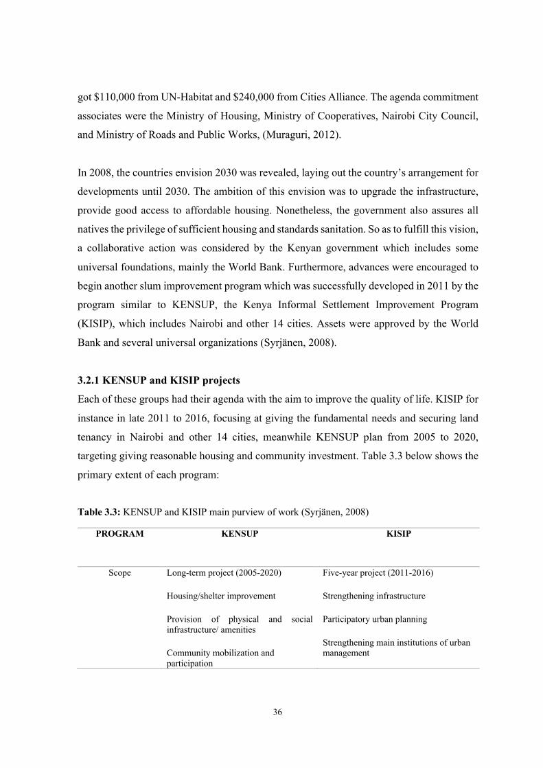
36
got $110,000 from UN-Habitat and $240,000 from Cities Alliance. The agenda commitment
associates were the Ministry of Housing, Ministry of Cooperatives, Nairobi City Council,
and Ministry of Roads and Public Works, (Muraguri, 2012).
In 2008, the countries envision 2030 was revealed, laying out the country’s arrangement for
developments until 2030. The ambition of this envision was to upgrade the infrastructure,
provide good access to affordable housing. Nonetheless, the government also assures all
natives the privilege of sufficient housing and standards sanitation. So as to fulfill this vision,
a collaborative action was considered by the Kenyan government which includes some
universal foundations, mainly the World Bank. Furthermore, advances were encouraged to
begin another slum improvement program which was successfully developed in 2011 by the
program similar to KENSUP, the Kenya Informal Settlement Improvement Program
(KISIP), which includes Nairobi and other 14 cities. Assets were approved by the World
Bank and several universal organizations (Syrjänen, 2008).
3.2.1 KENSUP and KISIP projects
Each of these groups had their agenda with the aim to improve the quality of life. KISIP for
instance in late 2011 to 2016, focusing at giving the fundamental needs and securing land
tenancy in Nairobi and other 14 cities, meanwhile KENSUP plan from 2005 to 2020,
targeting giving reasonable housing and community investment. Table 3.3 below shows the
primary extent of each program:
Table 3.3: KENSUP and KISIP main purview of work (Syrjänen, 2008)
PROGRAM KENSUP KISIP
Scope Long-term project (2005-2020)
Housing/shelter improvement
Provision of physical and social infrastructure/ amenities
Community mobilization and participation
Five-year project (2011-2016)
Strengthening infrastructure
Participatory urban planning
Strengthening main institutions of urban management
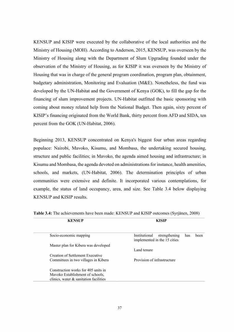
37
KENSUP and KISIP were executed by the collaborative of the local authorities and the
Ministry of Housing (MOH). According to Anderson, 2015, KENSUP, was overseen by the
Ministry of Housing along with the Department of Slum Upgrading founded under the
observation of the Ministry of Housing, as for KISIP it was overseen by the Ministry of
Housing that was in charge of the general program coordination, program plan, obtainment,
budgetary administration, Monitoring and Evaluation (M&E). Nonetheless, the fund was
developed by the UN-Habitat and the Government of Kenya (GOK), to fill the gap for the
financing of slum improvement projects. UN-Habitat outfitted the basic sponsoring with
coming about money related help from the National Budget. Then again, sixty percent of
KISIP’s financing originated from the World Bank, thirty percent from AFD and SIDA, ten
percent from the GOK (UN-Habitat, 2006).
Beginning 2013, KENSUP concentrated on Kenya's biggest four urban areas regarding
populace: Nairobi, Mavoko, Kisumu, and Mombasa, the undertaking secured housing,
structure and public facilities; in Mavoko, the agenda aimed housing and infrastructure; in
Kisumu and Mombasa, the agenda devoted on administrations for instance, health amenities,
schools, and markets, (UN-Habitat, 2006). The determination principles of urban
communities were extensive and definite. It incorporated various contemplations, for
example, the status of land occupancy, area, and size. See Table 3.4 below displaying
KENSUP and KISIP results.
Table 3.4: The achievements have been made: KENSUP and KISIP outcomes (Syrjänen, 2008)
KENSUP KISIP
Socio‐economic mapping
Master plan for Kibera was developed
Creation of Settlement Executive Committees in two villages in Kibera
Construction works for 405 units in Mavoko Establishment of schools, clinics, water & sanitation facilities
Institutional strengthening has been implemented in the 15 cities
Land tenure
Provision of infrastructure
38
3.2.2 KENSUP and KISIP dynamics of achievement
The two projects appreciated genuine government support monetarily and terms of giving
the required workforce. From one perspective, KENSUP was legitimately ratified by setting
up a Slum Development Department in the management of the Ministry of Housing.
However, inside the agenda, a Slum Upgrading Fund, which devoted about $14 billion to
actualize the agenda, was made. Furthermore, KENSUP was supported through assets from
the federal financial plan. The KISIP agenda likewise got an advance from the World Bank,
added $166 million (Anderson, 2015).
An additional fundamental aspect of the achievement was collaborating with the public
cooperators in the development strategy. Moreover, KENSUP utilized houses organizations
as a method for public preparation. The Department of Management and Ministry of
Cooperative Development has shaped several organizations in Kibera, Mavoko and other
four housing organizations that remained at that point shaped and enrolled in Soweto. With
the help in the development by the local community and the Housing Cooperatives Society,
slums are reflected as an accomplishment in itself. Collaborative support was perceived as
the top component for upgrading and development projects.
Collaborative action has successfully made both programs accomplish their goals.
According to (UN-Habitat, 2006), KENSUP included the participation of UN-Habitat and
GOK while KISIP included the joint effort of the World Bank, performed by the
Government. The collaborative idea of the agenda, drew upon the skill of each accomplice
to accomplish effective accomplishment. Such groups models are seen as instances in a way
to plan functional techniques to address the Millennium Development Goals (MDG) test of
giving safely sheltered and reasonable employment specially to the informal areas.
The key standards of KENSUP were associations, transference, democratization, establish-
ment, extension, resource mobilization, responsibility, transparency, sustainability, secure
tenure. Moreover, the established of the agenda SEC the Settlement Executive Committee
was the top agenda, comprising of slum residents. Since the administration's fundamental
concern was dispersal of evidence and choices regarding the agenda. Other institutional parts
of KENSUP incorporated the: Program administrative offices (in the Ministry), the Local
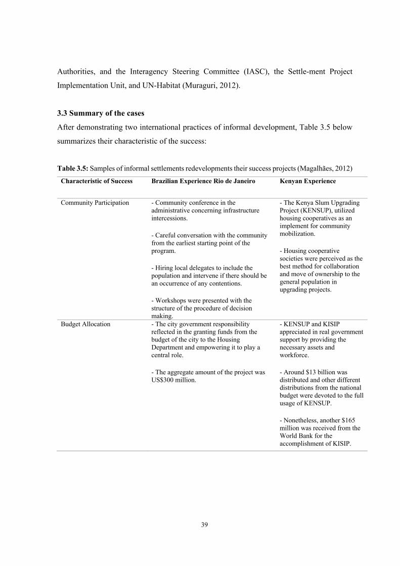
39
Authorities, and the Interagency Steering Committee (IASC), the Settle-ment Project
Implementation Unit, and UN-Habitat (Muraguri, 2012).
3.3 Summary of the cases
After demonstrating two international practices of informal development, Table 3.5 below
summarizes their characteristic of the success:
Table 3.5: Samples of informal settlements redevelopments their success projects (Magalhães, 2012)
Characteristic of Success Brazilian Experience Rio de Janeiro Kenyan Experience
Community Participation - Community conference in the administrative concerning infrastructure intercessions.
- Careful conversation with the community from the earliest starting point of the program.
- Hiring local delegates to include the population and intervene if there should be an occurrence of any contentions.
- Workshops were presented with the structure of the procedure of decision making.
- The Kenya Slum Upgrading Project (KENSUP), utilized housing cooperatives as an implement for community mobilization.
- Housing cooperative societies were perceived as the best method for collaboration and move of ownership to the general population in upgrading projects.
Budget Allocation - The city government responsibility reflected in the granting funds from the budget of the city to the Housing Department and empowering it to play a central role.
- The aggregate amount of the project was US$300 million.
- KENSUP and KISIP appreciated in real government support by providing the necessary assets and workforce.
- Around $13 billion was distributed and other different distributions from the national budget were devoted to the full usage of KENSUP.
- Nonetheless, another $165 million was received from the World Bank for the accomplishment of KISIP.
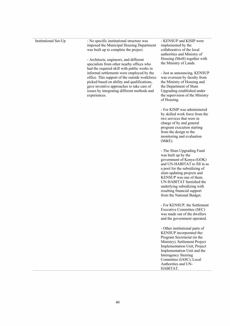
40
Institutional Set-Up - No specific institutional structure was imposed the Municipal Housing Department was built up to complete the project.
- Architects, engineers, and different specialists from other nearby offices who had the required skill with public works in informal settlements were employed by the office. This support of the outside workforce picked based on ability and qualifications, gave inventive approaches to take care of issues by integrating different methods and experiences.
- KENSUP and KISIP were implemented by the collaborative of the local authorities and Ministry of Housing (MoH) together with the Ministry of Lands.
- Just as announcing, KENSUP was overseen by faculty from the Ministry of Housing and the Department of Slum Upgrading established under the supervision of the Ministry of Housing.
- For KISIP was administered by skilled work force from the two services that were in charge of by and general program execution starting from the design to the monitoring and evaluation (M&E).
- The Slum Upgrading Fund was built up by the government of Kenya (GOK) and UN-HABITAT to fill in as a pool for the subsidizing of slum updating projects and KENSUP was one of them. UN-HABITAT furnished the underlying subsidizing with resulting financial support from the National Budget.
- For KENSUP, the Settlement Executive Committee (SEC) was made out of the dwellers and the government operated.
- Other institutional parts of KENSUP incorporated the: Program Secretariat (in the Ministry), Settlement Project Implementation Unit, Project Implementation Unit and the Interagency Steering Committee (IASC), Local Authorities and UN-HABITAT.
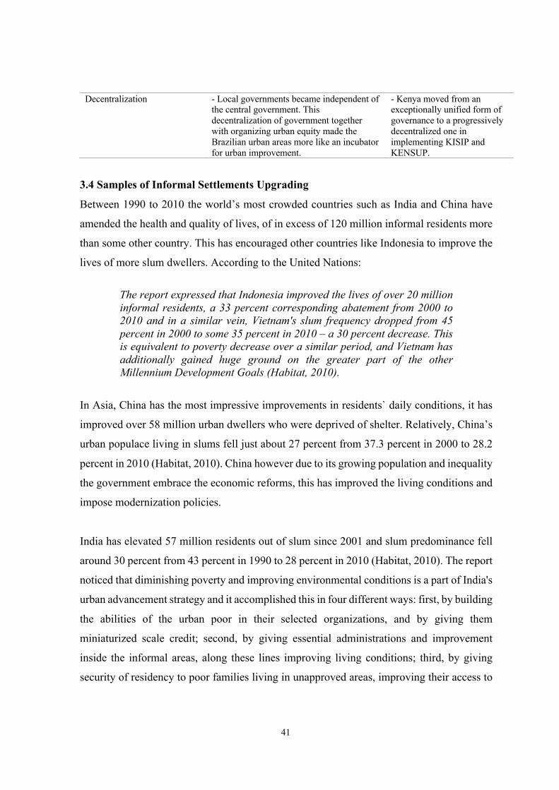
41
Decentralization - Local governments became independent of the central government. This decentralization of government together with organizing urban equity made the Brazilian urban areas more like an incubator for urban improvement.
- Kenya moved from an exceptionally unified form of governance to a progressively decentralized one in implementing KISIP and KENSUP.
3.4 Samples of Informal Settlements Upgrading
Between 1990 to 2010 the world’s most crowded countries such as India and China have
amended the health and quality of lives, of in excess of 120 million informal residents more
than some other country. This has encouraged other countries like Indonesia to improve the
lives of more slum dwellers. According to the United Nations:
The report expressed that Indonesia improved the lives of over 20 million informal residents, a 33 percent corresponding abatement from 2000 to 2010 and in a similar vein, Vietnam's slum frequency dropped from 45 percent in 2000 to some 35 percent in 2010 – a 30 percent decrease. This is equivalent to poverty decrease over a similar period, and Vietnam has additionally gained huge ground on the greater part of the other Millennium Development Goals (Habitat, 2010).
In Asia, China has the most impressive improvements in residents` daily conditions, it has
improved over 58 million urban dwellers who were deprived of shelter. Relatively, China’s
urban populace living in slums fell just about 27 percent from 37.3 percent in 2000 to 28.2
percent in 2010 (Habitat, 2010). China however due to its growing population and inequality
the government embrace the economic reforms, this has improved the living conditions and
impose modernization policies.
India has elevated 57 million residents out of slum since 2001 and slum predominance fell
around 30 percent from 43 percent in 1990 to 28 percent in 2010 (Habitat, 2010). The report
noticed that diminishing poverty and improving environmental conditions is a part of India's
urban advancement strategy and it accomplished this in four different ways: first, by building
the abilities of the urban poor in their selected organizations, and by giving them
miniaturized scale credit; second, by giving essential administrations and improvement
inside the informal areas, along these lines improving living conditions; third, by giving
security of residency to poor families living in unapproved areas, improving their access to
42
overhauled low-cost housing and sponsored housing finance; and fourth, by urging the poor
to partake in basic leadership and community improvement endeavors.
3.4.1 Yantai’s upgrading projects in China
The UN-Habitat (2008) reports that a significant urban redesigning venture was executed in
Yantai, China. Four fundamental kinds of housing and urban updating methodologies were
distinguished:
§ Urban overhauling, that spotlights on improving the physical situations in
neighborhoods
§ Improvement of urban infrastructural amenities and administrations
§ Community-wide advancement
§ Multi-sector urban upgrading
Figure 3.3: A pleasant open space instead of illegal structures in an upgraded Yantai
neighbourhood (UN-Habitat, 2008)
A significant territory of advancement in Yantai's redesigning program is that the outer walls
of more than 420 private structures were remodeled. Additionally, private structures
assessed at 280 were re-roofed. The knowledge was to build the security against the brutal
cold climate and diminished energy utilization.
43
3.4.2 Exemplifications of informal settlements in Africa
In Africa, Morocco has moved over 2 million out of informal situations in the past 10 years,
about 46 percent decrease in slum dominance because of solid political management, clear
targets and sufficient budget assets (Habitat, 2010). In a similar vein, Egypt and South Africa
have made improvements in the upgrading of slums (Alliance, 2008). Egypt decreased its
extent of informal residents by 40 percent; slum dominance fell by 28 percent of the urban
populace in 2000 to about 17 percent in 2010: in total numbers, the Government of Egypt
improved the living conditions of 5,000,000 individuals (Habitat, 2010).
3.4.2.1 Cairo, Egypt
Egypt is among the developing country that also suffers from informal developments. Egypt
has suffered over the past decades in rapid urbanization, this had caused the rise of informal
urbanization and informal housing supply. As per (Davis, 2006) “Planet of Slums” 2006,
about 40 percent (12 million) of the urban population in Egypt, live in slums. Cairo is among
the 30th “mega-slums” in the world. These mega slums in Cairo are Ezbet El-Haggana (1.1
million) and Imbaba (1.1 million). Within the Egyptian, the slum areas are known as ‘Ash-
wa’iyyat’, which truly signifies ‘disordered’ or ‘indiscriminate’. It alludes to informal
territories experiencing issues of accessibility, slender streets, lack of public spaces and free
land, extremely high densities neighborhoods, and inadequate structure and administrations.
Informal areas are viewed as the predominant method for development, extending on urban
edges, likewise on exclusive agricultural land. It has designated housing built disregarding
existing urban planning regulation and the construction regulation, frequently by changing
over (lawfully possessed) farming area to urban uses without land subdivision or building
licenses, and in practically all cases without enrolled property titles (regardless of whether
legitimately claimed land or squatter) (Soliman, 2011). People illegally build houses for their
own in the agricultural land or offer the destinations to others as development land, in this
situation people are turning the agricultural land into barren land. This sort represents about
eighty percent of informal urbanization in Egypt (MHUUD, 2008). It is evaluated that over
sixty percent of the area's populace inhabits these territories (Sims, 2011). Besides, it is
assessed that somewhere in the range of 1980 and 2025 almost fifty percent of Egypt's
agricultural land will be lost to slums residents without arranging or the capacity to imple-
44
ment the existent laws administering the environmental improvement (UNDP/INP, 2004).
This has turned into a danger to the occupants, to the houses and their living conditions.
However, in 2008 the Informal Settlements Development Facility (ISDF) was created by the
Egyptian government, as indicated by (ISDF, 2012). The ISDF supplanted the expressions
“slums,” and “informal areas,” to two different names: “unsafe” and “unplanned” regions,
keeping the new brought together, which gave these new classifications. Furthermore, the
primary objective of ISDF is guaranteeing secure houses and upgrading the personal
satisfaction of the residents in hazardous territories in Egypt (Pieterse, 2011).
The General Organization of Physical Planning (GOPP) reported on how to improve the
environment by a project titled “Upgrading of the urban and living environments for the
informal dwellers through collaborative action” are arranged in three-method for
intercession in informal regions; Containment, redevelopment, and upgrading. Renovation
is the completed expulsion of slums and can be called ‘Rehabilitation’. With regards to the
control, it is organizing a program on the peripheries of the city so as to stop the informal
slither on the agricultural land. Informal development is evaluated to have devoured about a
6th of the nation's customary agricultural land in the previous nineteen years (UNDP, 2004).
The Egyptian government implemented some ways of managing the informal areas. The
primary method is to protect the inhabitants by which procedures are taken to confine the
development of the informal areas. With an arranging strategy validated by the
administration to end the external extension of the slum regions by nearby encompassing
them with strategic areas (Tadamun, 2014). The following method is the dominant one
where the administration mediates to upgrade or evacuate the slum zones (Sims, 2008). The
approach was implemented from 2004-2008 as part of upgrading program in the informal
areas.
This project, however, contains two divisions, the first stage from 1994-2004 which aimed
to upgrade the quality of life and fundamental facilities and infrastructure, for instance,
consumable water, electricity, sanitary, landscaping, road sanitation, and public lighting,
greening just as creating disintegrate territories. The government of Egypt created a project
in 1996-2000 called “Mubarak Youth Housing Project”. The project’s purpose was to give
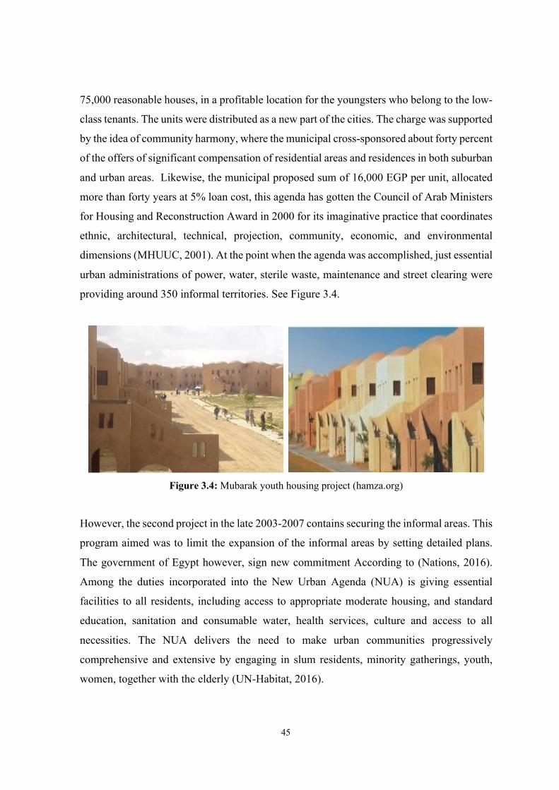
45
75,000 reasonable houses, in a profitable location for the youngsters who belong to the low-
class tenants. The units were distributed as a new part of the cities. The charge was supported
by the idea of community harmony, where the municipal cross-sponsored about forty percent
of the offers of significant compensation of residential areas and residences in both suburban
and urban areas. Likewise, the municipal proposed sum of 16,000 EGP per unit, allocated
more than forty years at 5% loan cost, this agenda has gotten the Council of Arab Ministers
for Housing and Reconstruction Award in 2000 for its imaginative practice that coordinates
ethnic, architectural, technical, projection, community, economic, and environmental
dimensions (MHUUC, 2001). At the point when the agenda was accomplished, just essential
urban administrations of power, water, sterile waste, maintenance and street clearing were
providing around 350 informal territories. See Figure 3.4.
Figure 3.4: Mubarak youth housing project (hamza.org)
However, the second project in the late 2003-2007 contains securing the informal areas. This
program aimed was to limit the expansion of the informal areas by setting detailed plans.
The government of Egypt however, sign new commitment According to (Nations, 2016).
Among the duties incorporated into the New Urban Agenda (NUA) is giving essential
facilities to all residents, including access to appropriate moderate housing, and standard
education, sanitation and consumable water, health services, culture and access to all
necessities. The NUA delivers the need to make urban communities progressively
comprehensive and extensive by engaging in slum residents, minority gatherings, youth,
women, together with the elderly (UN-Habitat, 2016).
46
The new urban agenda did not just focus on developing the housing, also the quality of the
residents living in the slum and informal areas rather than represent and improve the quality
of life of those people. According to (Egypt's Constitution of 2014, 2016).
"The state shall guarantee the citizens' right to satisfactory, sheltered and solid housing in a way which preserves human respect and accomplishes social equity. The state shall develop a general housing plan which maintains the environmental disposition and guarantees the commitment of individual and community activities in its usage. The state shall likewise direct the utilization of state lands and secure them with fundamental utilities inside the structure of complete urban arranging which serves urban areas and towns and a populace dispersion technique. This is to be applied in a way assisting the public interest, improving the quality of life for residents and protections the privileges of who and what is to come. The state shall likewise devise a far-reaching national plan to address the issue of spontaneous slums, which incorporates re-arranging, providing of infrastructure and services, and development of the personal satisfaction and healthcare. Also, the state shall ensure the arrangement of assets for actualizing such arrangement inside a predetermined timeframe."
In the case of Egypt, the specialists received a participatory advancement system with the
goal of: “characterizing the structure for upgrading living conditions in the informal areas;
giving an instrument to overseeing and checking the updating exercises in every territory;
organizing the limit improvement of neighborhood organization staff working with the
governorate and regions; encouraging trust-building exercises between nearby organizations
and inhabitants of informal regions, upgrading their connection and feeling of ownership for
as key accomplices; and planning the replication of best practices of managing informal
zones through the governorate” (Alliance, 2008).
3.4.2.2 South Africa
In South Africa, a sustainable livelihood method for slum development was embraced. This
procedure has various components, including: “pledge to in-situ improvement as a first need;
full community studies as the wellspring of full data on community conditions, and
consequent fitting of advancement mediations; close counsel with families, and
augmentation of decision over house types and levels of administrations to guarantee
affordability; fortifying social capital by the advancement of clubs and social orders, for
47
instance, youth and women’s gatherings, or social and recreational gatherings; access to
software engineers on fundamental training abilities preparing, work procedures, and how
to get to assets for learning” notwithstanding these preferences, the sustainable livelihoods
approach contrived in South Africa considers the “utilization of maintainable urban plan
amplifying utilization of layout and topography and direction of properties, unit mix, size
and dispersion; detached warm structure of singular units, just as protection and roof
establishment; empowering organizations in and around local locations; encouraging the
arrangement of financial and specialized administrations to organizations at their different
phases of advancement; supporting open works programs and the utilization of nearby work;
the utilization of community improvement laborers to spur and sort out community
improvement activities and data gathering” (Alliance, 2008).
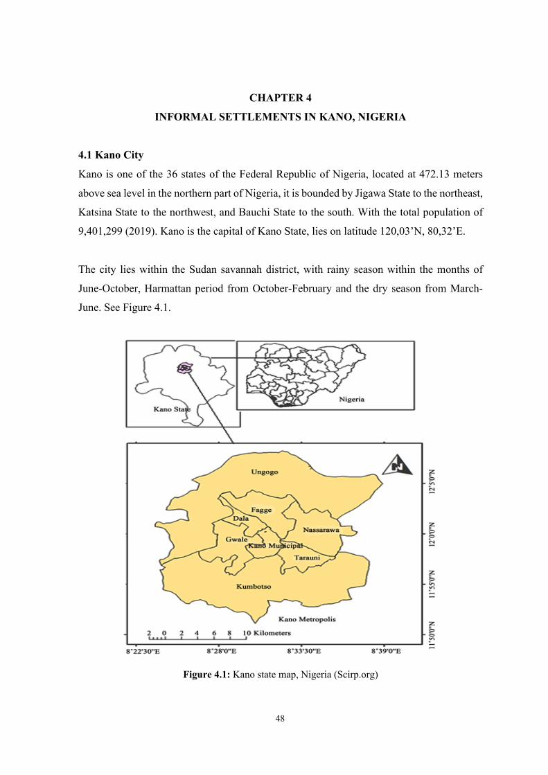
48
CHAPTER 4
INFORMAL SETTLEMENTS IN KANO, NIGERIA
4.1 Kano City
Kano is one of the 36 states of the Federal Republic of Nigeria, located at 472.13 meters
above sea level in the northern part of Nigeria, it is bounded by Jigawa State to the northeast,
Katsina State to the northwest, and Bauchi State to the south. With the total population of
9,401,299 (2019). Kano is the capital of Kano State, lies on latitude 120,03’N, 80,32’E.
The city lies within the Sudan savannah district, with rainy season within the months of
June-October, Harmattan period from October-February and the dry season from March-
June. See Figure 4.1.
Figure 4.1: Kano state map, Nigeria (Scirp.org)
49
Historical evolution of Kano
Kano is one of the oldest and historical city in Nigeria. Kano was established around Dala
Hill in the 7th century A.D. Local chiefdoms kept on developing in time and the city of Kano
accounts the first king Bagauda a grandson of the legendary, fabulous hero Bayajidda, whose
ascension was stated to be in the year 999 AD, ruling until 1063 AD (Adamu, 1984). The
city became a dominant town in the region at the 11th century and continues to grow
progressively by the 15th century partly owing to the introduction of the camel, it had
assumed an important role in the trans-Sahara trade route. The trans-Sahara trade was linked
through a spatial hierarchy of regional marketing towns starting from the forest zones of the
west African coast up to the Mediterranean ports of north Africa, the latter forming the
highest tier of this hierarchy as outlets of the African subcontinent contribution to this trade
(Mabogunje 1990). However, although the trans-Saharan trade was important in the growth
of towns along its route, especially Kano which grew progressively from the 14th century
almost oblivious of the constant political conflicts and wars which marked the rise and fall
of the succession of empires of the western Sudan, other factors within and around the
subregion also had important influence on its growth and prosperity (Tapela, 1988). Here
the interaction of the social politics, economic and environmental factors provides the basis
of Kano’s growth and stability as well as shaping its urban form.
Kano was a city with defensive walls built-in (1095-1134) to protect its inhabitants. The
Ancient Kano City Walls were defined as “the greatest landmark in west Africa”. They
enclose an area of 19.2 km2, which began from the eastern part at Kurmi market near the
Jakara stream (Dankani, 2011). After national independence, Kano perceived uncommon
urbanization and hasty population growth due to financial change in the state. This
incorporated the improvement of modern, private and business land utilizes, which in turn
acted as a magnet for other financial exercises that ascend to the metropolitan development.
See Table 4.1.
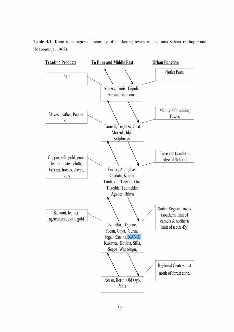
50
Table 4.1: Kano inter-regional hierarchy of marketing towns in the trans-Sahara trading route
(Mabogunje, 1968).
51
The Kano walls, as well as its surroundings, are included in a tentative list of UNESCO for
being a World Heritage site since last 08/10/2007 (National, 2007). According to ISESCO:
According to historical sources the first settlement in the territory of the metropolitan of Kano goes back to 500 BC, Hausa, Fulani, and Kanuri were among the clans that settled around there. Most historical sources accept that Islam was brought into the state after the passing of the Prophet Mohammed (peace and prayer be upon him), in the period of the friends, and explicitly during the rule of Caliph Uthman ibn Affan (23-35 H/643-655) (may Allah be pleased with him), who sent forces under the command and direction of Abdullah ibn Sa'ad ibn Abi as-Sarḥ, as a part of the Muslim triumphs in Africa (ISESCO, 2013).
Other than the old walled region (perceived as Kano city in 1961), Kano has four different
areas, Fagge as one that is possessed by ‘strangers’, Hausa societies, additionally Sabon
Gari, housing immigrants from the east and southern region of Nigeria, however, the Syrian
neighborhoods and neighboring commercial township (1912) and Nassarawa the European
and African settlement, site of present-day government structures.
Kano city is artistically known as ‘Kasar Hausa’, a center of agriculture, furniture, cement,
textiles, and rolled steel. A large portion of the state's occupants are Hausa or Fulani,
speaking English as an official language for the state. Hausa transcribed in Arabic also
spoken across the state, however, there are additionally Nigerians (Dual Citizens) from
different parts of the country, Arabian and Europeans traders. Kano city has glorious market
centers Rano, and Wudil, however railways and international airport.
Kano a city with a long history and lots of traditions, which include traditional ways of
storing and exporting. One of the famous export called ‘Peanuts Pyramids’, the locals
bagged and stored Peanuts (groundnuts) in a hug pyramids styles before being export or sent
to any other state in Nigeria. Hides and Skins are the second most important traditional
export. There is an impressive animals trade, sheep, and cattle that are raised on local farms
shipping to Lagos and other parts. Eggs likewise are distributed to different parts of Nigeria.
Traditional industries include leather tanning and decoration, tailoring, metalworking, mat
making, and pottery manufacturing. Traditional dye pits for cloth and leather have been
utilized for centuries.
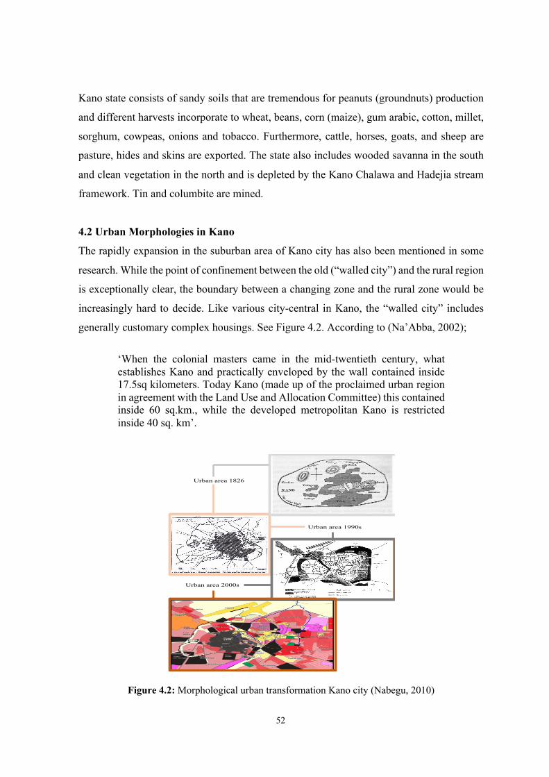
52
Kano state consists of sandy soils that are tremendous for peanuts (groundnuts) production
and different harvests incorporate to wheat, beans, corn (maize), gum arabic, cotton, millet,
sorghum, cowpeas, onions and tobacco. Furthermore, cattle, horses, goats, and sheep are
pasture, hides and skins are exported. The state also includes wooded savanna in the south
and clean vegetation in the north and is depleted by the Kano Chalawa and Hadejia stream
framework. Tin and columbite are mined.
4.2 Urban Morphologies in Kano
The rapidly expansion in the suburban area of Kano city has also been mentioned in some
research. While the point of confinement between the old (“walled city”) and the rural region
is exceptionally clear, the boundary between a changing zone and the rural zone would be
increasingly hard to decide. Like various city-central in Kano, the “walled city” includes
generally customary complex housings. See Figure 4.2. According to (Na’Abba, 2002);
‘When the colonial masters came in the mid-twentieth century, what establishes Kano and practically enveloped by the wall contained inside 17.5sq kilometers. Today Kano (made up of the proclaimed urban region in agreement with the Land Use and Allocation Committee) this contained inside 60 sq.km., while the developed metropolitan Kano is restricted inside 40 sq. km’.
Figure 4.2: Morphological urban transformation Kano city (Nabegu, 2010)
Urban area 1826
Urban area 1990s
Urban area 2000s
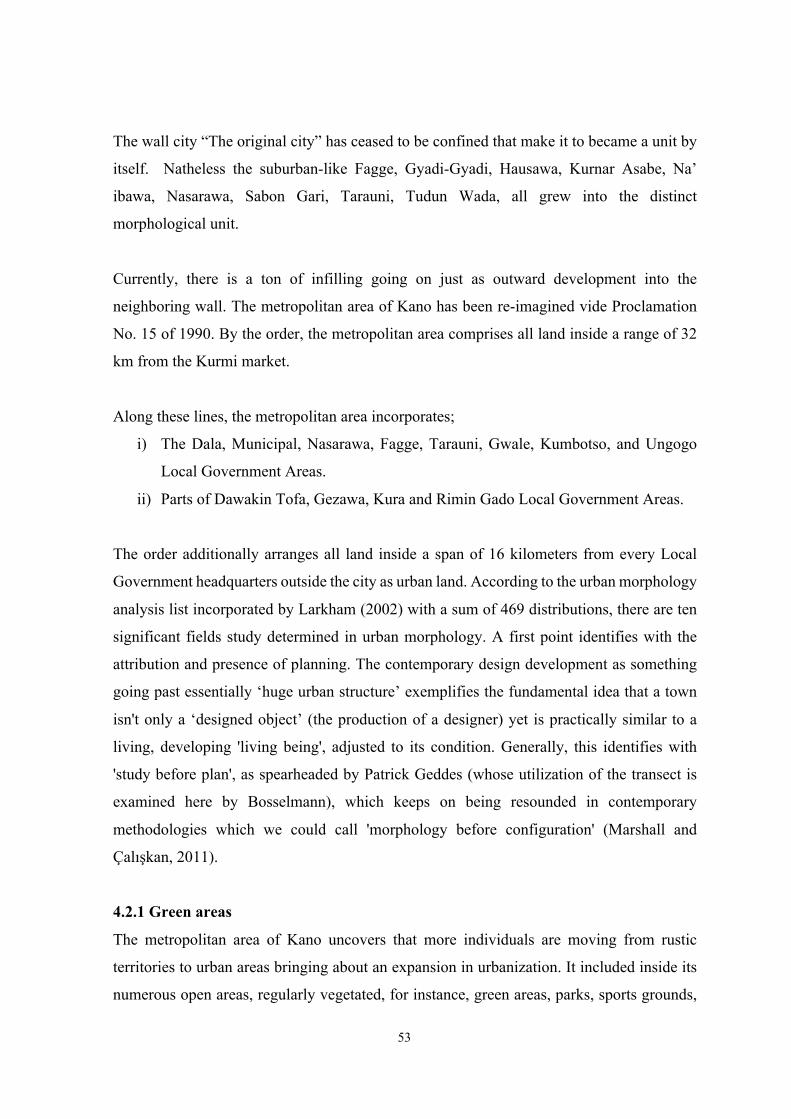
53
The wall city “The original city” has ceased to be confined that make it to became a unit by
itself. Natheless the suburban-like Fagge, Gyadi-Gyadi, Hausawa, Kurnar Asabe, Na’
ibawa, Nasarawa, Sabon Gari, Tarauni, Tudun Wada, all grew into the distinct
morphological unit.
Currently, there is a ton of infilling going on just as outward development into the
neighboring wall. The metropolitan area of Kano has been re-imagined vide Proclamation
No. 15 of 1990. By the order, the metropolitan area comprises all land inside a range of 32
km from the Kurmi market.
Along these lines, the metropolitan area incorporates;
i) The Dala, Municipal, Nasarawa, Fagge, Tarauni, Gwale, Kumbotso, and Ungogo
Local Government Areas.
ii) Parts of Dawakin Tofa, Gezawa, Kura and Rimin Gado Local Government Areas.
The order additionally arranges all land inside a span of 16 kilometers from every Local
Government headquarters outside the city as urban land. According to the urban morphology
analysis list incorporated by Larkham (2002) with a sum of 469 distributions, there are ten
significant fields study determined in urban morphology. A first point identifies with the
attribution and presence of planning. The contemporary design development as something
going past essentially ‘huge urban structure’ exemplifies the fundamental idea that a town
isn't only a ‘designed object’ (the production of a designer) yet is practically similar to a
living, developing 'living being', adjusted to its condition. Generally, this identifies with
'study before plan', as spearheaded by Patrick Geddes (whose utilization of the transect is
examined here by Bosselmann), which keeps on being resounded in contemporary
methodologies which we could call 'morphology before configuration' (Marshall and
Çalışkan, 2011).
4.2.1 Green areas
The metropolitan area of Kano uncovers that more individuals are moving from rustic
territories to urban areas bringing about an expansion in urbanization. It included inside its
numerous open areas, regularly vegetated, for instance, green areas, parks, sports grounds,
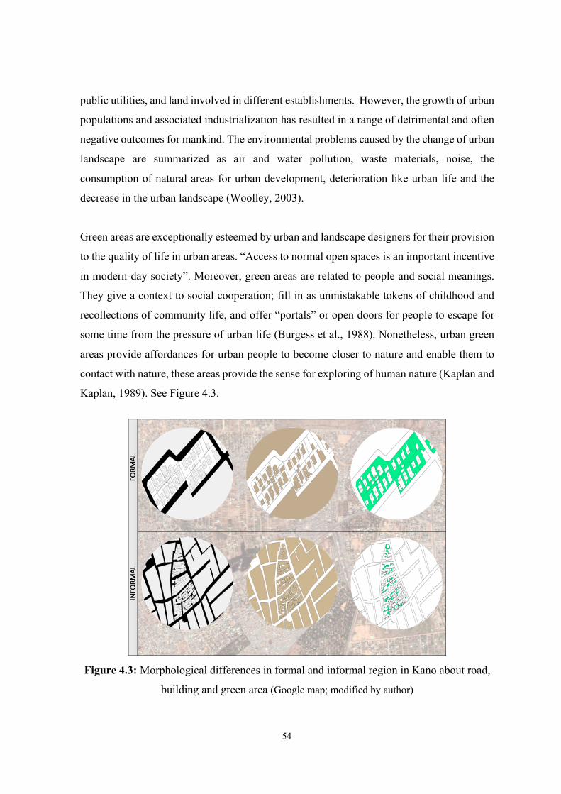
54
public utilities, and land involved in different establishments. However, the growth of urban
populations and associated industrialization has resulted in a range of detrimental and often
negative outcomes for mankind. The environmental problems caused by the change of urban
landscape are summarized as air and water pollution, waste materials, noise, the
consumption of natural areas for urban development, deterioration like urban life and the
decrease in the urban landscape (Woolley, 2003).
Green areas are exceptionally esteemed by urban and landscape designers for their provision
to the quality of life in urban areas. “Access to normal open spaces is an important incentive
in modern-day society”. Moreover, green areas are related to people and social meanings.
They give a context to social cooperation; fill in as unmistakable tokens of childhood and
recollections of community life, and offer “portals” or open doors for people to escape for
some time from the pressure of urban life (Burgess et al., 1988). Nonetheless, urban green
areas provide affordances for urban people to become closer to nature and enable them to
contact with nature, these areas provide the sense for exploring of human nature (Kaplan and
Kaplan, 1989). See Figure 4.3.
Figure 4.3: Morphological differences in formal and informal region in Kano about road,
building and green area (Google map; modified by author)
55
Urban green areas serve for common purposes although they are defined by different types.
They provide users shadow physical comfort such as clean air and resting places, and formal
or informal social interactions such as a combination of different social groups and traditions
and opportunities regarding the cultural experience in urban areas (Lawton, 2007). See
Figure 4.4.
Figure 4.4: Kano urban green areas
Along with the ongoing urbanization movement, urban spaces are expanded without
thinking the green space development, and rural lands are transformed into built-up areas
(Kabisch et al., 2014). However, according to (Groening and Bulmahn, 1989) in the past,
urban green areas were recreative and symbolic places where people provide their food,
today they are considered as a way to ensure the individual's relation with the nature, to bring
the natural life into the city and to make cities more livable. Urban zones have been the most
significant segments of the city that implies a great deal as spaces where people have endured
in each moment of life by changing in some cases into landscapes which are simply looked
for the city-occupants, now and then into parks where the life is shared and individuals
dispose of the pressure of everyday life, once in a while into shelter for kids, and
playgrounds. Urban green areas benefits are as follows, economic, environmental, health
benefits, social.
Economic benefits
§ Creation of job opportunities, providing services to local, regional people and tourists
in green areas, employment of people responsible for the maintenance of these areas
(Dunnett et al., 2002; Wright, 2011).
56
§ Creation of general economic impacts; green areas attract investments by increasing
the quality of the areas where they exist, increase the values of those areas in
particular, increase the values of the real estates in their surroundings and support the
local economies (Woolley, 2003; Byrne and Sipe, 2010; Wright, 2011; Jim and Chen,
2009; Kabisch et al., 2015).
§ The well planned and designed green areas that increase the attractiveness of the city
contribute to tourism and thus economy (Dunnett et al., 2002; Byrne and Sipe, 2010).
§ The presence of green areas decreases the heating and cooling costs of the buildings
by their climate balancing features and reduces the negative effects caused by them
(Byrne and Sipe, 2010).
Environmental benefits
The environmental benefits of urban green areas are associated with features of climate and
environmental improvement, providing opportunities for habitats (Woolley, 2003),
improving aesthetic appearance (McCormack et al., 2010; Sugiyama et al., 2010), improving
the urban landscape and the city's livability.
§ The plants that constitute urban green areas reduce the air pollution by seizing the
particles, absorbing the heavy metals and polluting gasses and assuming the task of
filtering air (Dunnet et al., 2002; Lawton, 2007).
§ They play a role in improving the urban air quality, improving the urban climate and
decreasing the noise level (Gidlöf Gunnarsson and Öhrström, 2007).
§ They reduce the negative effect of urban areas on natural water sources by ensuring
the absorption and retention of rain waters, and they control the water regime
(Niemelä, 2014).
§ Urban green areas create cool urban spaces and mitigate the urban heat island effect
(Lawton, 2007).
Health benefits
Urban zones make a sentiment of fulfillment in the person alongside getting away from the
challenges of the living situations and the dynamic involvement in nature by guaranteeing
individuals working in a bustling program to dispose of their day by day weariness and noise
of the city. To touch, see, hear and smell the elements that constitute the natural world can
57
make people get rid of their thoughts, refresh people, and provide them with a sense of peace
and calmness (Kaplan, 1989). However poor-quality urban areas, lacking green areas
indirectly affect the physical health of the individuals of city dwellers; and the negative
emotions caused by mental stress lead to cardiovascular diseases by increasing the blood
pressure of the individual and negatively affect the mental health of the individual due to
asthma, cancer and metabolic disorders (Lawton, 2007).
Benefits of urban green areas to physiological health:
§ Accelerate recovering from various types of cancer (Byrne and Sipe, 2010).
§ Allow people to fight against obesity and heart disease caused by a sedentary lifestyle
(Byrne and Sipe, 2010).
§ Decrease the chronic health risks such as nervous system damage and heavy metal
poisoning (Wright, 2011).
§ Improve the general state of health (De Vries et al., 2003; Maas et al., 2006).
§ Lower the blood pressure (Qin j et al., 2013).
§ Prolong the life span (Takano et al., 2002; Schipperijn et al., 2010).
Benefits of urban green areas to psychological health:
The effects of urban green areas on psychological health can be classified under five main
headings (Rohde and Kendle, 1994):
§ Behavioral; they increment the exploratory and courageous disposition supporting or
shaping confidence.
§ Cognitive; they reduce mental fatigue and refresh the attention (Kaplan, 1989).
§ Developmental; they support children's healthy development by encouraging a
higher level of mental activity in them (Özgüner, 2003).
§ Emotional; they decrease the stress, increase individual's positive feelings about
himself (Ulrich et al., 1991; Grahn and Stigsdotter, 2003; Ulrich, 2006; Nielsen and
Hansen, 2007; Byrne and Sipe, 2010), positively affect the individual's experiences
that renew and offer health (Hartig et al., 2003; Van den Berg et al., 2010).
§ Social; they encourage natural habitat interaction, advance communication between
social boundaries and even give a more extensive social responsibility in some cases.
58
Social benefits
Green areas have two capacities as far as public activity: green areas give people the chance
to feel the solace outside their living spaces and in this manner make them feel that they are
related to a more prominent social structure. These areas allow people to be alone as well as
allowing them to share life with many people; and even they sometimes include places that
will allow people to be alone in the crowds (Thompson, 2002; Jim and Chen, 2009; Byrne
and Sipe, 2010). Secondly, green areas serve as the gathering place for people to
communicate with each other; people become acquainted with others, young people get rid
of the heavy responsibilities even just for a while (Burgess et al., 1988). It is, however, the
spaces that help to shape the community's attitudes and to develop the identity of the
community and that provide continuity from the past to present become important for
neighbors and obtain a social value and meaning (Project for Public Space, 2000).
Nevertheless, the green areas structure the child development by providing children with the
opportunity to have energetic playgrounds based on imagination with the facilities in the
outer space and ensure that children interact with adults (Woolley, 2003). This situation
positively affects the children's social and cognitive development, teaches them the social
values and coping with difficulties, and gives them physical and mental health (Wheater et
al., 2007).
Accessibility
Land accessibility as characterized by Cotula et al., 2006 are the procedures by which people
(exclusively or collectively) gain rights and chances to involve and use land principally for
beneficial purposes and other financial and social purposes, regardless of whether on an
impermanent or permanent principle. However, the people who live in the informal areas
are lacking access to several utilities, education systems, health care, clean water, wealth,
power and social connections. According to (Abdulraheem et al., 2012; Abimbola et al.,
2012) The eminence of health-care amenities is poor and stays a tremendous source of
concern. Nonetheless, accessible education is key to achieving these goals (Eneh, 2005). The
Figure 4.5 and Table 4.2 below indicates the level of accessibility in Kano.
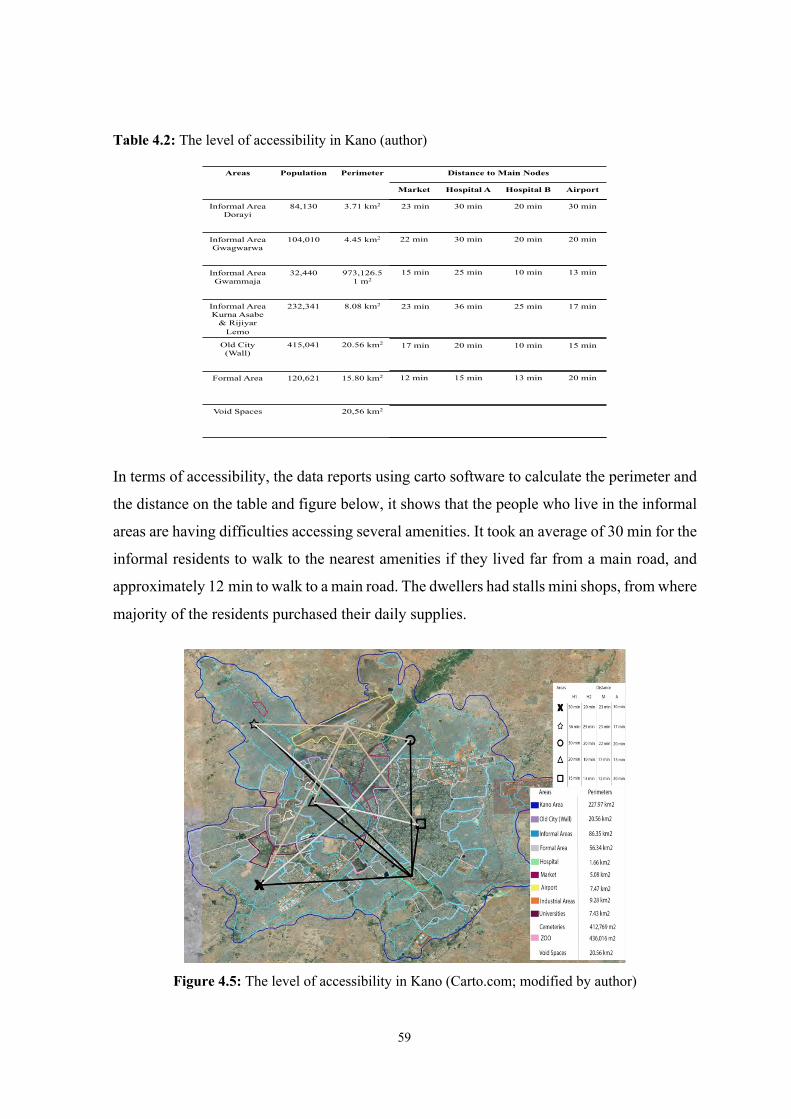
59
Table 4.2: The level of accessibility in Kano (author)
In terms of accessibility, the data reports using carto software to calculate the perimeter and
the distance on the table and figure below, it shows that the people who live in the informal
areas are having difficulties accessing several amenities. It took an average of 30 min for the
informal residents to walk to the nearest amenities if they lived far from a main road, and
approximately 12 min to walk to a main road. The dwellers had stalls mini shops, from where
majority of the residents purchased their daily supplies.
Figure 4.5: The level of accessibility in Kano (Carto.com; modified by author)
Areas Population Perimeter Distance to Main Nodes
Informal Area Dorayi
84,130 3.71 km2
Informal Area Gwagwarwa
104,010 4.45 km2
Informal Area Gwammaja
32,440 973,126.51 m2
Informal Area Kurna Asabe
& RijiyarLemo
232,341 8.08 km2
Old City (Wall)
415,041 20.56 km2
Formal Area 120,621 15.80 km2
Void Spaces 20,56 km2
Market Hospital A Hospital B Airport
23 min 30 min 20 min 30 min
22 min 30 min 20 min 20 min
15 min 25 min 10 min 13 min
23 min 36 min 25 min 17 min
17 min 20 min 10 min 15 min
12 min 15 min 13 min 20 min
60
4.3 Analysis of Informal Settlement in Kano, Nigeria
For many periods, Kano has been the major center of commerce and the most dominant town
in the Sudan zone. The metropolis area of Kano is one among the fasters growing city in
Nigeria, with over 1000 inhabitants per km2 within a settled zone compared to the average
of 260 inhabitants per km2. This has made the city of Kano congested. According to (UNDP,
2004) the city also has a large migrant worker population which has been increasing at the
rate of 25 to 45 percent per annum, these figures show that some of the suburban areas will
likely be organized and would be required in innovative strategies. Kano has been
encountering higher populace development and quick urbanization since its independence
in 1960 (Nabegu, 2010; Dankani, 2013; Muhammad et al., 2014). For example, in 1932, the
number of inhabitants in Kano was evaluated to be just 83,000, by 1952, it was estimated at
127,000, while it had expanded to 295,432 nonetheless between 1963 to 1991 it was
estimated at 1.6 million and 2.84 million in 2006 enumeration, and its present development
rate was evaluated at 5.5% per annum (Dankani, 2013; Mustapha, 2013; Mustapha, 2008).
The growth has caused a high demand for houses in Kano. As indicated by (National
Population Commission (NPC), 2009) “Kano has over 750,000 youthful family units whose
age was somewhere in the range of 24 to 45 years representing 6 percent of the national
figure”. The present populace development of Kano city prompts an expansion in the
requests for urban amenities and managements including housing which is right now
insufficient both in terms of amount and quality (Muhammad, 2014). This circumstance
resulted on the rise of slums and unexpected neighborhoods inside the city which are
developing faster than the designed neighborhoods (Dankani, 2013). See the descriptions in
Table 4.3 and Figure 4.6.
Table 4.3: Kano residential area illustration
Type of Settlements Area (km2) Population Area (%) Population (%) Average
density (p/ha)
Formal 56.34 3,078,247 28.2% 33% 96
Informal 86.35 6,323,042 71.8% 67% 310
Total Residential Area 142.69 9,401,288 100% 100% 406
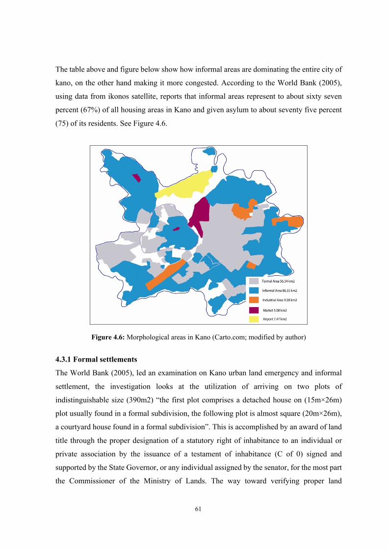
61
The table above and figure below show how informal areas are dominating the entire city of
kano, on the other hand making it more congested. According to the World Bank (2005),
using data from ikonos satellite, reports that informal areas represent to about sixty seven
percent (67%) of all housing areas in Kano and given asylum to about seventy five percent
(75) of its residents. See Figure 4.6.
Figure 4.6: Morphological areas in Kano (Carto.com; modified by author)
4.3.1 Formal settlements
The World Bank (2005), led an examination on Kano urban land emergency and informal
settlement, the investigation looks at the utilization of arriving on two plots of
indistinguishable size (390m2) “the first plot comprises a detached house on (15m×26m)
plot usually found in a formal subdivision, the following plot is almost square (20m×26m),
a courtyard house found in a formal subdivision”. This is accomplished by an award of land
title through the proper designation of a statutory right of inhabitance to an individual or
private association by the issuance of a testament of inhabitance (C of 0) signed and
supported by the State Governor, or any individual assigned by the senator, for the most part
the Commissioner of the Ministry of Lands. The way toward verifying proper land
62
designation starts by making a sign of enthusiasm through the acquisition of an application
structure for direct allocation (the form is normally sold by the Ministry of Lands). At the
point when the procedure is completed, it has come back to the ministry together with all the
vital reports required to be submitted close by the finished application form, for example, a
visa photo of the candidate and their biological documentation (required to determine the
candidate is mature enough generally 18 years to hold a land title). Other mandatory records
incorporate a tax clearance certificate and if the candidate is a government worker, a salary
‘pay-slip’ to guarantee tax is being deducted from the income of the candidate. At the point
when the form has come back to the ministry, a non-refundable charge is paid which shifts
from 2,500 nairas (£12.50) for a high-density and low-density plot to 5,000 nairas (£25.00).
From that point, a record is appointed for the name of the candidate with the Registry
Department where it is continued pending a land provision being made. The designation is
obviously expected to be made by the Land Use and Allocation Committee as gave in
segment 2 subsection 2 (a) of the Land Use Decree of 1978. The board should consider all
candidates at whatever point another format is planned and will be dispensed.
The provision along these lines straightforwardly in the hands of the Ministry Commissioner
in contact with the Director of Lands and the Director of Survey. Frequently, just a couple
of the records of candidates in the library are viewed as when a portion will be made. Most
of the recipients are individuals informally conceded into the allotment procedure by
compelling people and government dignitaries. On numerous events, people have distributed
a plot of land even before they buy the application form. Moreover, the circumstance turns
out to be increasingly hard for the system to be carefully clung to, in light of the fact that
applications are gotten consistently while the designs are apportioned just at times and
regularly unpredictably. In this way, at some random timeframe, the office has a few
thousand applications recording up for a long time while the designs contain a couple of
hundred plots, the greatest consistently being 'Zawaciki' with 1500 plots. This further gives
chance for immorality as candidates battle to get a designation from the few plots on any
layout.
Besides, three different kinds of settlements could be found in the city of Kano. The well off
(commercial people, professionals, high positioning directors) live in high-value contempo-
63
rary neighborhoods, for example, the GRA, with the low density of population and buildings,
walled by green belts. These areas have created under contemporary development strategies,
have great openness and connectivity and are ensured by zoning guidelines. The
accentuation here is on the nuclear family unit (Chokor, 2005). Numerous migrant dealers
and businessmen, who can't stand to live in GRA, live in houses urbanized by private
property intrigues that are inspired by benefits rather a worry for African qualities, in
medium-density neighborhoods. At long last, the poor have no other decision yet to live in
swarmed, self-built houses regularly arranged ashore involved unlawfully and lacking access
to most fundamental utilities and services.
We can simply characterize three zones in Kano, according to the densities: low-density
neighbourhoods, medium-density, and high-density ones. The high-density neighborhoods
have over 270 persons living in one hectare of land, however, in the medium neighborhoods
are between 100 to 300 persons in one hectare of land and in some low-density
neighborhoods is below 100 persons in one hectare of land.
High density settlements
The high-density neighborhood is described by low accessibility, particularly to motorized
vehicles. Most inhabitants here are low-salary workers, in spite of the fact that there is
likewise some center to high-pay government workers and business people. There are more
than 2129 houses in the area with 19,395 dwellers.
Medium density settlements
The medium density neighborhood is generally well-arranged and has great accessibility.
Most inhabitants here are middle-income, high-pay and businessmen (for the most part
government workers, businessmen, and security staff). An average of 7,545 individuals lives
in the 865 housing units in this area.
Low density settlements
The low-density neighborhood has a very much spread out arrangement with great
accessibility. As projected, most inhabitants of this area are high-pay workers. There are
3885 inhabitants living in 786 housing units. This is a low-density neighborhood with a well-
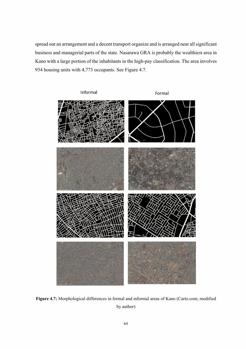
64
spread out an arrangement and a decent transport organize and is arranged near all significant
business and managerial parts of the state. Nasarawa GRA is probably the wealthiest area in
Kano with a large portion of the inhabitants in the high-pay classification. The area involves
934 housing units with 4,773 occupants. See Figure 4.7.
Figure 4.7: Morphological differences in formal and informal areas of Kano (Carto.com; modified
by author)
65
4.3.2 Informal settlements
Informal settlements have been existing in Kano for a long time, but were not considered by
the authority as illegal. During the early nineteenth century, the city has rapidly expanded in
trade and other economic opportunities this has brought about the growth of the population
and the city of Kano itself. Kano became one of the famous city in Nigeria also known as
the canter of trade, it was during this period when the other side of Kano city began to
develop and suburban locations like rijiyar lemo, kurna, and so on were set up. Occupants
were ‘permitted to do as they liked’ in many issues of architecture, plan, and improvement
(Myers, 1999). Numerous cities in these countries have large areas of unplanned
developments, (Busgeeth, 2008). This gave space for lots of people from the informal areas
to manufacture their homes on these free lands with no planning guidelines.
This experience of illicit land subdivision and plot has spread generally over the peri-urban
zone, bringing about the development of the urban cities. Land can be assigned to a second
party where a legal right of inhabitance has been conceded to a first party, providing all the
lawful systems to such moves have been pursued. The way toward distancing such a
privilege of inhabitance, includes the survey of the land, more often than not did by
registered property examiners and valuer’s, to decide its fairly estimated worth. The activity
of informal markets in the city is on the expansion as showed by the expanding unlawful
subdivisions of private plots and the physical improvement of informal areas inside the city.
An interviewee supports:
...In the event that you take a look at the degree of informal growth particularly here in Kano, the informal developers are more dynamic than the formal ones. In fact, I can reveal to you these people are much more dynamic than the government itself regarding getting land, as far as the improvement of housing, as far as opening up barren spots' (Ado Muhktar, 2010).
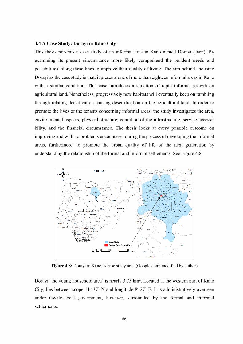
66
4.4 A Case Study: Dorayi in Kano City
This thesis presents a case study of an informal area in Kano named Dorayi (Jaen). By
examining its present circumstance more likely comprehend the resident needs and
possibilities, along these lines to improve their quality of living. The aim behind choosing
Dorayi as the case study is that, it presents one of more than eighteen informal areas in Kano
with a similar condition. This case introduces a situation of rapid informal growth on
agricultural land. Nonetheless, progressively new habitats will eventually keep on rambling
through relating densification causing desertification on the agricultural land. In order to
promote the lives of the tenants concerning informal areas, the study investigates the area,
environmental aspects, physical structure, condition of the infrastructure, service accessi-
bility, and the financial circumstance. The thesis looks at every possible outcome on
improving and with no problems encountered during the process of developing the informal
areas, furthermore, to promote the urban quality of life of the next generation by
understanding the relationship of the formal and informal settlements. See Figure 4.8.
Figure 4.8: Dorayi in Kano as case study area (Google.com; modified by author)
Dorayi ‘the young household area’ is nearly 3.75 km2. Located at the western part of Kano
City, lies between scope 11o 37’ N and longitude 8o 27’ E. It is administratively overseen
under Gwale local government, however, surrounded by the formal and informal
settlements.
Dodayi Case Study Kano
Kano State
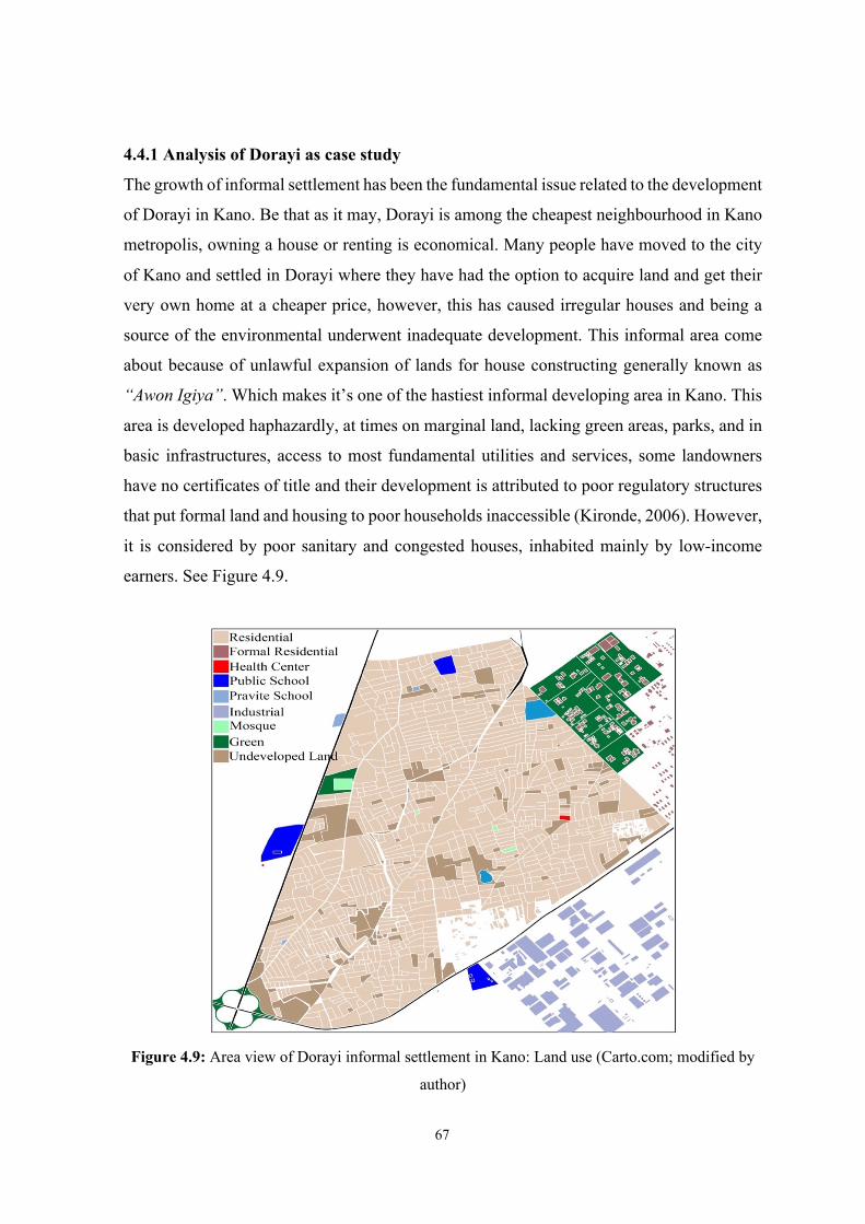
67
4.4.1 Analysis of Dorayi as case study
The growth of informal settlement has been the fundamental issue related to the development
of Dorayi in Kano. Be that as it may, Dorayi is among the cheapest neighbourhood in Kano
metropolis, owning a house or renting is economical. Many people have moved to the city
of Kano and settled in Dorayi where they have had the option to acquire land and get their
very own home at a cheaper price, however, this has caused irregular houses and being a
source of the environmental underwent inadequate development. This informal area come
about because of unlawful expansion of lands for house constructing generally known as
“Awon Igiya”. Which makes it’s one of the hastiest informal developing area in Kano. This
area is developed haphazardly, at times on marginal land, lacking green areas, parks, and in
basic infrastructures, access to most fundamental utilities and services, some landowners
have no certificates of title and their development is attributed to poor regulatory structures
that put formal land and housing to poor households inaccessible (Kironde, 2006). However,
it is considered by poor sanitary and congested houses, inhabited mainly by low-income
earners. See Figure 4.9.
Figure 4.9: Area view of Dorayi informal settlement in Kano: Land use (Carto.com; modified by
author)

68
Demographic profile
Dorayi is known as the young household’s neighborhood, however, known as the crowded
neighbourhood because of the population and had a large number of attached houses, most
of them are young couples, women and youngsters under the age of twenty-five. The
population density is about 84,130 and it will increment as the territory is attracting more
population from close by rustic regions. The number of low-income people is higher over
seventy percent 70% of the houses in this area are single story and thirty percent 30% are
two stories.
Land use and activities analysis
The area used to be a small rural settlement with a large portion of its occupant is Fulani and
some working in agriculture. However, because of the illicit transformation of agricultural
land into structures, it becomes an area that attracts young households because of its
inexpensive and its proximity to the educational institution, and the main city. Which courses
the uncontrolled growth and non-adherence to planning rules and guidelines from Kano State
Urban Planning and Development Agency (KNUPDA) before developing their plots.
Furthermore, inefficient planning and corruption are the main factors responsible for non-
adherence to planning rules and guidelines often forcing developers to develop property
without following the due process usually with the connivance of corrupt planning officers,
nonetheless, the planning rules and policies are constantly changing depending on which
government or lawmakers are in power at the time and also depending on which bearcats
have drafted the legislation.
Accessibility
The moral accessibility to the area is through Sheikh Jafar Mahmud way or Sharada road.
(Figure 4.10). Dwellers must reach Sheikh Jafar Mahmud way to find public transportations.
Dorayi alleys are poorly connected to public transportations, for instance bus stations.
However, transportation is mainly by motor tricycle (Keke napep), motorcycle or private
cars. The streets are unpaved, very narrow with no sidewalks, making it more dangerous
especially in the spring (Raining Season). Furthermore, this appears to suggest the
importance of access in this neighbourhood and more facilities such as fire brigades, health
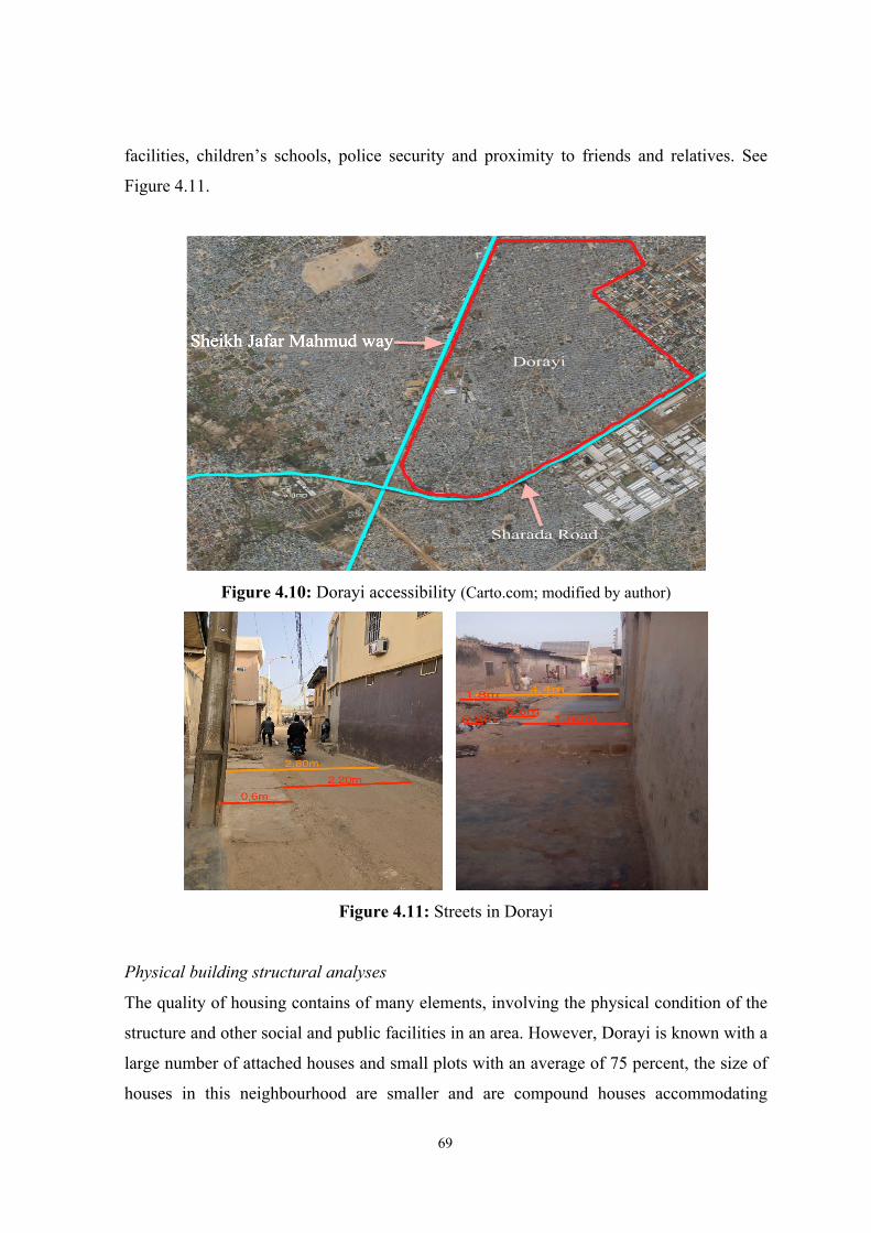
69
facilities, children’s schools, police security and proximity to friends and relatives. See
Figure 4.11.
Figure 4.10: Dorayi accessibility (Carto.com; modified by author)
Figure 4.11: Streets in Dorayi
Physical building structural analyses
The quality of housing contains of many elements, involving the physical condition of the
structure and other social and public facilities in an area. However, Dorayi is known with a
large number of attached houses and small plots with an average of 75 percent, the size of
houses in this neighbourhood are smaller and are compound houses accommodating
Sheikh Jafar Mahmud way
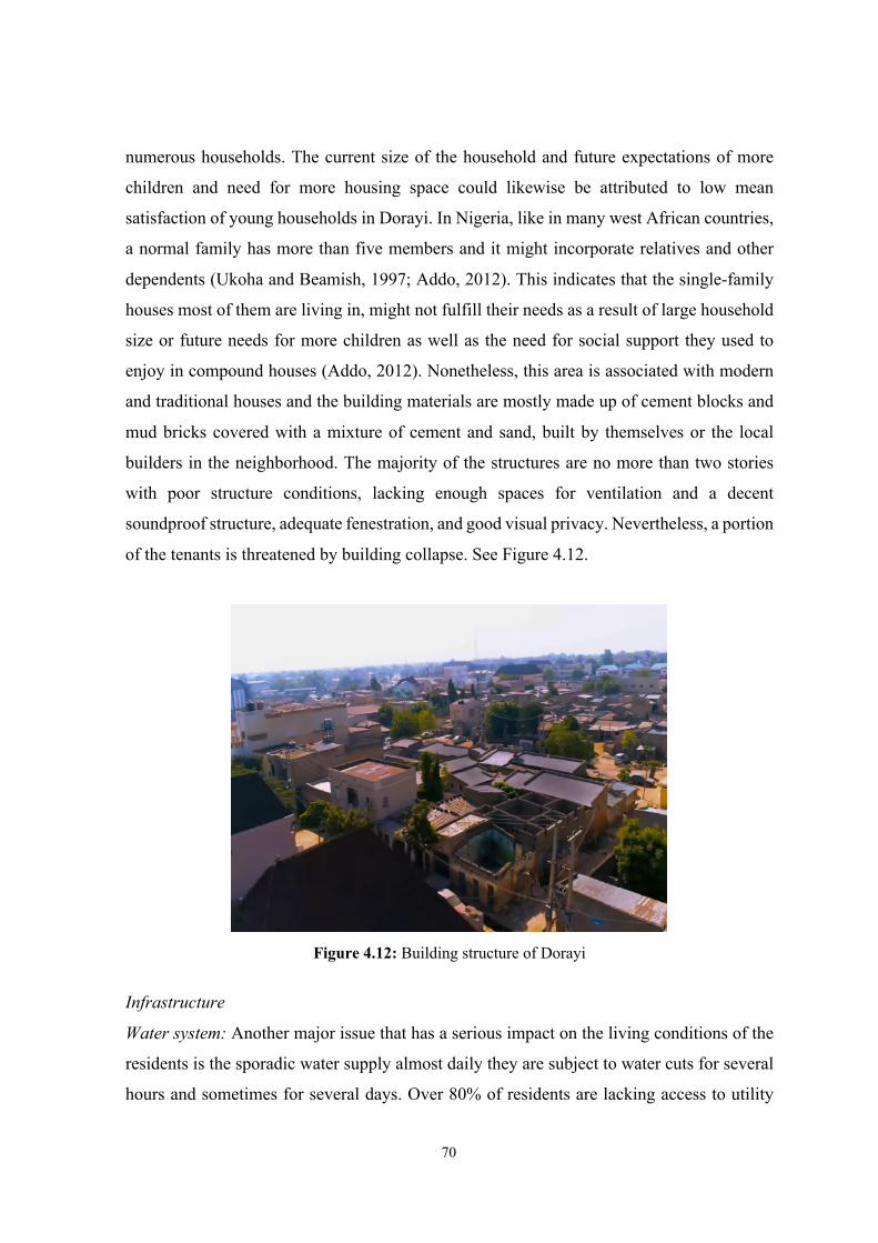
70
numerous households. The current size of the household and future expectations of more
children and need for more housing space could likewise be attributed to low mean
satisfaction of young households in Dorayi. In Nigeria, like in many west African countries,
a normal family has more than five members and it might incorporate relatives and other
dependents (Ukoha and Beamish, 1997; Addo, 2012). This indicates that the single-family
houses most of them are living in, might not fulfill their needs as a result of large household
size or future needs for more children as well as the need for social support they used to
enjoy in compound houses (Addo, 2012). Nonetheless, this area is associated with modern
and traditional houses and the building materials are mostly made up of cement blocks and
mud bricks covered with a mixture of cement and sand, built by themselves or the local
builders in the neighborhood. The majority of the structures are no more than two stories
with poor structure conditions, lacking enough spaces for ventilation and a decent
soundproof structure, adequate fenestration, and good visual privacy. Nevertheless, a portion
of the tenants is threatened by building collapse. See Figure 4.12.
Figure 4.12: Building structure of Dorayi
Infrastructure
Water system: Another major issue that has a serious impact on the living conditions of the
residents is the sporadic water supply almost daily they are subject to water cuts for several
hours and sometimes for several days. Over 80% of residents are lacking access to utility

71
systems, they acquire freshwater by filling plastic drums from a public tap. Water supply
had to be supplemented with alternative sources. To fill the gap in water supply, funds were
required for the provision of alternative sources in the form of boreholes and underground
wells. However, a significant water sanitization plant is expected to stay away from maladies
and serious medical problems brought about by contaminated water, for giving the principal
need to clean water. See Figure 4.13.
Figure 4.13: Public tap in Dorayi
Drainage system: Knowing that streets of Dorayi are very narrow with no sidewalks or
proffer drainage, it points out in the late 1980s, to date every year 80% of rains in Kano fell
within just three months (July, August, and September), putting more weight on drainage
systems, this at times, course flooding and had disastrous as a result. It was accounted for
that between 2003-2007, urban floods in Kano influenced 16,730 family units, resulting in
14 deaths and displacement of countless individuals (Barau, 2008). Close by these changes
in precipitation, few scholars have likewise noticed that anthropogenic procedures, for
instance, the loss of open spaces, agriculture land and blocked drainage, nonetheless
declining space for urban agriculture have occurred main causal elements to the repetitive
floods (Lynch et al., 2001). On the other hand, waste systems for the most part in an open
land tossed in water channels, generate diseases and ecological contamination generate,
therefore, is a major issue that could directly impact on the wellbeing of the people living in
this area. Its impact might be in the form of congestion, which has a variety of manifestations
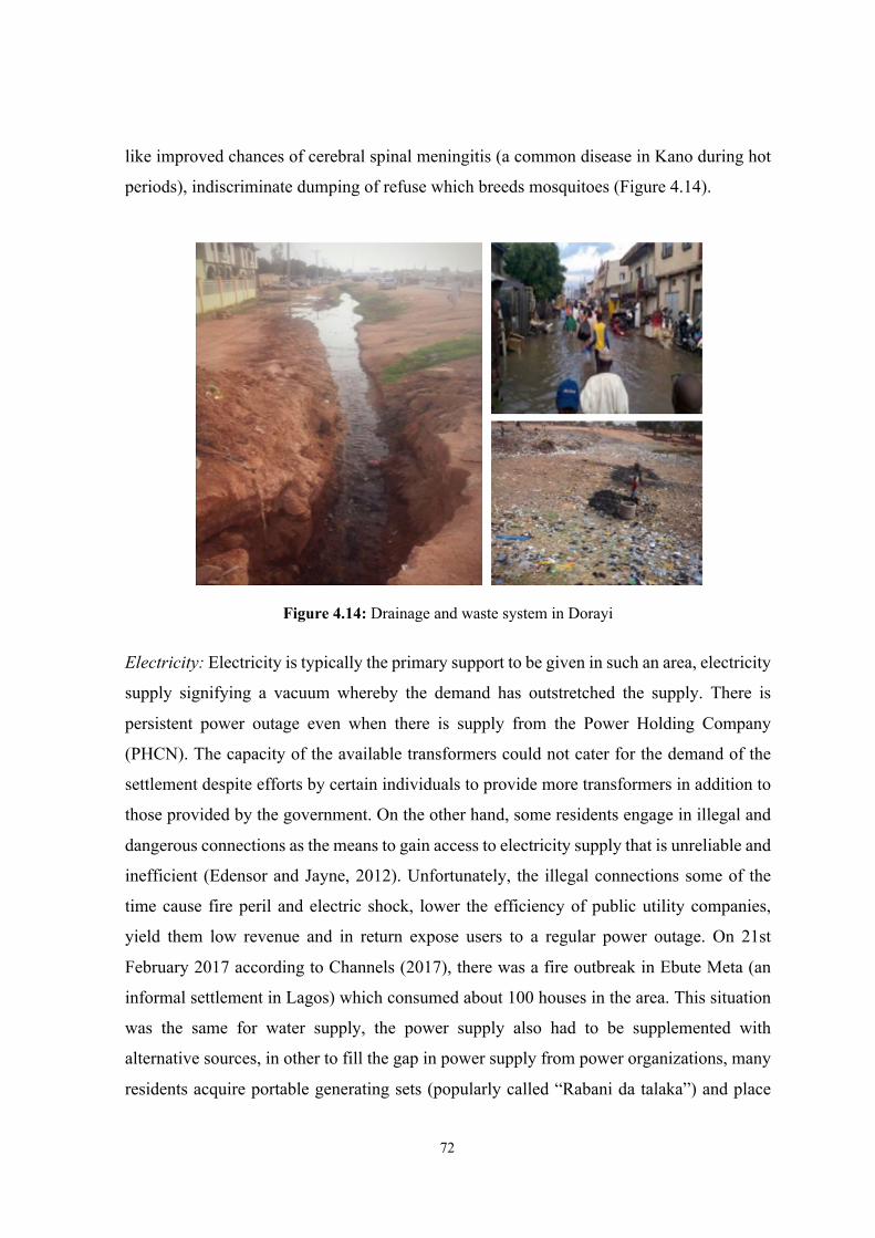
72
like improved chances of cerebral spinal meningitis (a common disease in Kano during hot
periods), indiscriminate dumping of refuse which breeds mosquitoes (Figure 4.14).
Figure 4.14: Drainage and waste system in Dorayi
Electricity: Electricity is typically the primary support to be given in such an area, electricity
supply signifying a vacuum whereby the demand has outstretched the supply. There is
persistent power outage even when there is supply from the Power Holding Company
(PHCN). The capacity of the available transformers could not cater for the demand of the
settlement despite efforts by certain individuals to provide more transformers in addition to
those provided by the government. On the other hand, some residents engage in illegal and
dangerous connections as the means to gain access to electricity supply that is unreliable and
inefficient (Edensor and Jayne, 2012). Unfortunately, the illegal connections some of the
time cause fire peril and electric shock, lower the efficiency of public utility companies,
yield them low revenue and in return expose users to a regular power outage. On 21st
February 2017 according to Channels (2017), there was a fire outbreak in Ebute Meta (an
informal settlement in Lagos) which consumed about 100 houses in the area. This situation
was the same for water supply, the power supply also had to be supplemented with
alternative sources, in other to fill the gap in power supply from power organizations, many
residents acquire portable generating sets (popularly called “Rabani da talaka”) and place
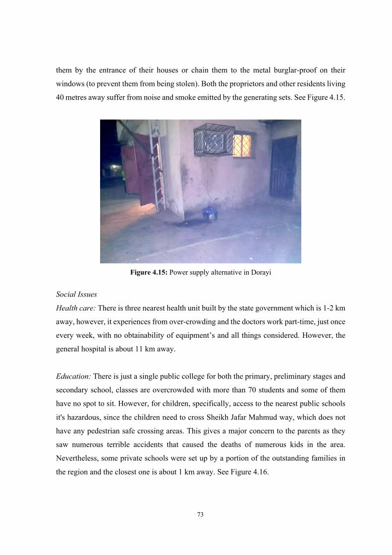
73
them by the entrance of their houses or chain them to the metal burglar-proof on their
windows (to prevent them from being stolen). Both the proprietors and other residents living
40 metres away suffer from noise and smoke emitted by the generating sets. See Figure 4.15.
Figure 4.15: Power supply alternative in Dorayi
Social Issues
Health care: There is three nearest health unit built by the state government which is 1-2 km
away, however, it experiences from over-crowding and the doctors work part-time, just once
every week, with no obtainability of equipment’s and all things considered. However, the
general hospital is about 11 km away.
Education: There is just a single public college for both the primary, preliminary stages and
secondary school, classes are overcrowded with more than 70 students and some of them
have no spot to sit. However, for children, specifically, access to the nearest public schools
it's hazardous, since the children need to cross Sheikh Jafar Mahmud way, which does not
have any pedestrian safe crossing areas. This gives a major concern to the parents as they
saw numerous terrible accidents that caused the deaths of numerous kids in the area.
Nevertheless, some private schools were set up by a portion of the outstanding families in
the region and the closest one is about 1 km away. See Figure 4.16.
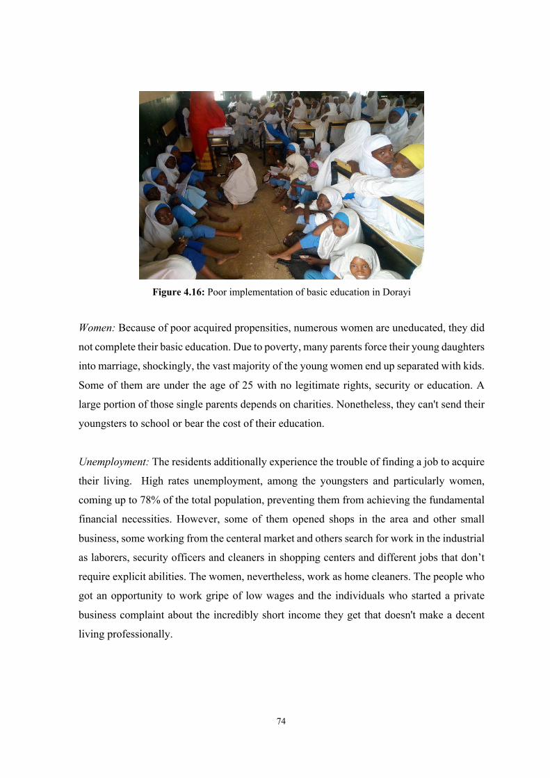
74
Figure 4.16: Poor implementation of basic education in Dorayi
Women: Because of poor acquired propensities, numerous women are uneducated, they did
not complete their basic education. Due to poverty, many parents force their young daughters
into marriage, shockingly, the vast majority of the young women end up separated with kids.
Some of them are under the age of 25 with no legitimate rights, security or education. A
large portion of those single parents depends on charities. Nonetheless, they can't send their
youngsters to school or bear the cost of their education.
Unemployment: The residents additionally experience the trouble of finding a job to acquire
their living. High rates unemployment, among the youngsters and particularly women,
coming up to 78% of the total population, preventing them from achieving the fundamental
financial necessities. However, some of them opened shops in the area and other small
business, some working from the centeral market and others search for work in the industrial
as laborers, security officers and cleaners in shopping centers and different jobs that don’t
require explicit abilities. The women, nevertheless, work as home cleaners. The people who
got an opportunity to work gripe of low wages and the individuals who started a private
business complaint about the incredibly short income they get that doesn't make a decent
living professionally.

75
CHAPTER 5
CONCLUSION & RECOMMENDATIONS
5.1 Conclusion
This study has sought to examine the phenomena of informal development; I have focused
on Kano, Dorayi as case study in particular, as it provides excellent examples of Nigerian
informal areas and housing environments. This thesis has inspected the issues of informal
settlement in Dorayi, Kano metropolitan area, highlighting the causes of a prevailing lack of
effectiveness. In addition, the thesis examines the success of other experiences in developing
countries to find out opportunities to apply in the events taken by the informal developments.
After the introduction as Chapter 1 that displays research problem, aim and objectives etc.,
the Chapter 2 of the thesis started by examining the issues on national cases that stimulate
public intervention in such areas and the factors that determine the success of such
mediations. In Chapter 3 some experiences in the developing nations around the world were
presented, whose accomplishments were the answers related to this issue. Nevertheless, the
study continues investigating several accomplishments from developing countries and in
Chapter 4 it focuses on understanding the situation of informal development in Kano
metropolis. According to the analysis, governments must play a leading role in recognizing
and dealing with the informal settlement/slum challenges, however the tenants of Dorayi are
beneficial endeavors between the all-inclusive community, the government should give
support and encouraged collaboration between tenant and other organizations.
The issues brought about by the presence of informal settlements are not a result of political
reasons, furthermore founded on the nonappearance of structure, sustainability,
policymaking, and common support. It was presumed that a large percentage of the
government intercessions is not focusing on that. Likewise, it should provide the basic needs
i.e. job opportunities, development of green areas and parks, access to reasonable
transportation, public services and so on. Furthermore, upgrading the health issues by
tackling the current situations of the clinics and hospitals, by providing a full-time doctor
with all specialties and equipment, nonetheless, preparing health training programs. On the
other hand, the educational system should be redesigning, because school facilities and
76
instructors are momentous to the absence of basic education. Lastly to introduce different
opportunities that will expand the resident’s income-earning.
5.2 Recommendations
To begin with any upgrading procedure or intermediation, strategy and accomplishment,
there are several and necessary steps that should be monitored within any project including
the authority to perceive the presence of informal areas. Nevertheless, refurbishing such area
is obligatory methods for intercession to address the poor living conditions in such region.
Considering the international studies shown earlier, any development should be certified by
every single organization agency involved and the government agencies. However, it is
important that the programs obtain the diplomatic assurance and determination of the
authority, by contributing to the local units for accomplishments and responsibilities of the
local authorities in every step.
For instance, as mentioned earlier in the thesis, the political and institutional authorities,
presented the project of Favela Bairro in Rio de Janeiro and was solely established by the
local government strategy moreover applied by workforces from the government authority.
However, the Brazilian metropolises are independent elements that took enough
independence to structure and implement their very own strategies separated from the
government. Along these lines, the local authorities attempted to take all the responsibilities
on the improvement and implementation of this agenda. However, the government
responsibility was likewise spoken to in designating an impressive segment of the city's
financial limit to the housing department and enabling it to assume a focal job.
Since informal settlement upgrading projects are overseen and directed at the state
government, the government should give the essential administrative willpower and standard
maintenance that can be imitated in locating the national policy for managing informal areas,
nonetheless, it should utilize significant activities at the local and national levels. Along
these lines, mediations are fundamental not just at the area or the program level as well as
the national and state governments levels, where budgets, strategies, and implementation are
made and assigned. Nonetheless, the levels of these mediations should be predictable and
supportive to accomplish the greatest outcomes.
77
Collaborative practice
Another significant strategy on that, the Kano state government should take essential
activities to support and invested in those community as demonstrated early in all the
international practices. Implementing a collaborative method, beginning with the residents,
then fellow by the physical development just as setting up a discussion for arranging several
alternatives incorporating with the residents in decision making is fundamental. On the other
hand, supporting the inhabitants to successfully take part in developing their very own
environments. Actualizing slum upgrading projects should depend on the people-focused
method where instruments to consult and inclusion of the residents are all united through the
entire procedure. An innovative thought, for example, the housing associations that were
applied in Kenya the KENSUP program is a successful program for a public organization.
Kano, however, might use such a method as an ability for new development and upgrading
the community.
Nevertheless, it is important to involve the informal residents for upgrading procedures and
decision making, throughout the crusades or workshops similar to the ones composed in the
Favela’s program to maintain a strategic distance from any hesitance or opposition on the
resident's part. Be that as it may, it’s important to understand public support as one of the
fundamental keys to every accomplishments and success. Meanwhile, the presence of expert
skill is important with the association of local groups. Likewise, the government support in
recognizing the informal areas and its characteristics by collaborating with informal dwellers
to win their trust through applying a collaborative method is also significant. This support
can be achieved by managing and implementing the informal developing projects.
As presented earlier according to the international experiences, it is important to concentrate
on the necessities and ambitions of the informal residents nevertheless, to realize that the
people leaving in such area have indistinguishable rights as others residents living in formal
area. Accordingly, the government should ensure and implement the following:
§ The privilege to create and additionally update the master plan for Kano city taking
into recognition the future improvement requirements.
78
§ The requirement for an intermittent quantifying and anticipating changes in land-
utilizes with the goal that its specialist infrastructural necessities can be met enough.
Such estimating and anticipating should be directed at a five-year interval.
§ The privilege of security for land and houses. Improvement in running clean water,
sufficient sewage transfer, a improving the prosperity of the resident and the most
important to legitimizing or regularizing the houses that need security.
§ The government should guarantee that all designs are as 'site and administrations'
layouts. Arrangement of this should be the duty of Governments at both State and
Local levels.
§ A special concern should be given to poor and low-income earners with the goal that
they can afford plots in areas where essential administrations are accessible.
§ The planners should ensure that all land delimited as urban is furnished with essential
set-up before development approval is given.
§ Urban administrators and planners should guarantee to observe an accessible
infrastructure with perception of managing them sustainably.
§ The government should cooperate with the private organization in the procedure and
the management of a fundamental structure. This will without a doubt supplement
the effort of the government.
§ A specific sum must be set by the government to solely give new and manage existing
structure. There should be solid legislation on consistence with this budgetary
project.
§ An integrated urban restoration strategy should be presented by the government in
areas already developed.
§ A water cleaning plant is expected to prevent infections caused by polluted water and
for giving the basic need to potable water.
79
REFERENCES
Adamu M. (1984). The Hausa and their neighbors in the central Sudan, in Niane, D.T. (Ed.),
UNESCO General History of Africa (pp. 266-300).
Abimbola S, Okoli U, Olubajo O, Abdullahi M J, Pate M A (2012). The Midwives Service
Scheme in Nigeria.
Abdulraheem I S, Olapipo A R, Amodu M O (2012). “Primary health care services in
Nigeria: critical issues and strategies for enhancing the use by the rural communities”,
Journal of Public Health and Epidemiology; (pp. 5-13).
Addo, I. A. (2013). Perceptions and acceptability of multihabitation as an urban low-income
housing strategy in greater Accra metropolitan area, Ghana. Urban Forum, Springer
(pp. 1-29).
Ado Muhktar Bichi, (2010). Land Accessibility and Implications for Housing Development
in Kano Metropolis, Nigeria. (pp. 212). Department of Geography the University of
Sheffield.
Afrol, News. (2003) Environmental Cleanup brightens up Lagos slum. from https://www-
.afrol.com.
Aliyu, Sule. (2006): Managing Slums in Delhi. Sabir Ali ed.: Managing Urban Poverty,
Uppal Publishing House, (pp. 432-517). New Delhi.
Alao, O. (2013). Plateau signs contracts for Jos flyover, 9 other projects Jos. from
https://www Daily Trust Online, Thursday, 14 February.
Alliance, C. (2008). The Cities Alliance. Slum upgrading up close: Experiences of six cities.
Washington, D.C.
Amado, M. P., Pinto, A. J., Santos, C. V. (2007) “The Sustainable Building Process”, (pp.
4-7). Proceedings of XXXV IAHS World Congress on Housing Science, Melbourne,
Australia.
Anderson, M. (2015). Kenyan Slum Upgrading Programs: KENSUP & KISIP. Nairobi.
Arimah, B. C. (2001). Slums as expression of social exclusion: Explaining the prevalence
of slums in African countries,. Paper presented at United Nations Human Settlement
Programme, held at Nairobi, Kenya,.
Arnott, R. (2009). Urbanization and Growth. Commission on growth and development
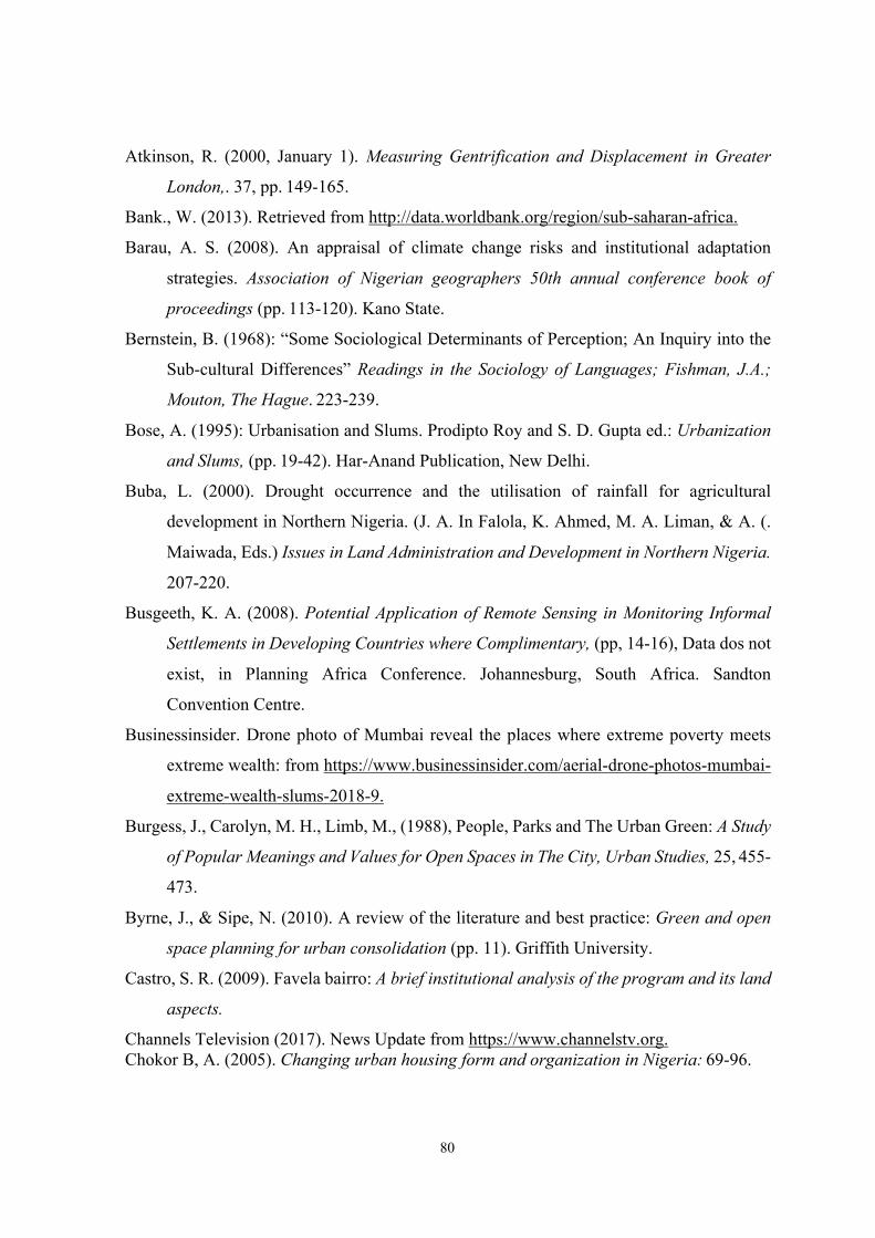
80
Atkinson, R. (2000, January 1). Measuring Gentrification and Displacement in Greater
London,. 37, pp. 149-165.
Bank., W. (2013). Retrieved from http://data.worldbank.org/region/sub-saharan-africa.
Barau, A. S. (2008). An appraisal of climate change risks and institutional adaptation
strategies. Association of Nigerian geographers 50th annual conference book of
proceedings (pp. 113-120). Kano State.
Bernstein, B. (1968): “Some Sociological Determinants of Perception; An Inquiry into the
Sub-cultural Differences” Readings in the Sociology of Languages; Fishman, J.A.;
Mouton, The Hague. 223-239.
Bose, A. (1995): Urbanisation and Slums. Prodipto Roy and S. D. Gupta ed.: Urbanization
and Slums, (pp. 19-42). Har-Anand Publication, New Delhi.
Buba, L. (2000). Drought occurrence and the utilisation of rainfall for agricultural
development in Northern Nigeria. (J. A. In Falola, K. Ahmed, M. A. Liman, & A. (.
Maiwada, Eds.) Issues in Land Administration and Development in Northern Nigeria.
207-220.
Busgeeth, K. A. (2008). Potential Application of Remote Sensing in Monitoring Informal
Settlements in Developing Countries where Complimentary, (pp, 14-16), Data dos not
exist, in Planning Africa Conference. Johannesburg, South Africa. Sandton
Convention Centre.
Businessinsider. Drone photo of Mumbai reveal the places where extreme poverty meets
extreme wealth: from https://www.businessinsider.com/aerial-drone-photos-mumbai-
extreme-wealth-slums-2018-9.
Burgess, J., Carolyn, M. H., Limb, M., (1988), People, Parks and The Urban Green: A Study
of Popular Meanings and Values for Open Spaces in The City, Urban Studies, 25, 455-
473.
Byrne, J., & Sipe, N. (2010). A review of the literature and best practice: Green and open
space planning for urban consolidation (pp. 11). Griffith University.
Castro, S. R. (2009). Favela bairro: A brief institutional analysis of the program and its land
aspects.
Channels Television (2017). News Update from https://www.channelstv.org. Chokor B, A. (2005). Changing urban housing form and organization in Nigeria: 69-96.
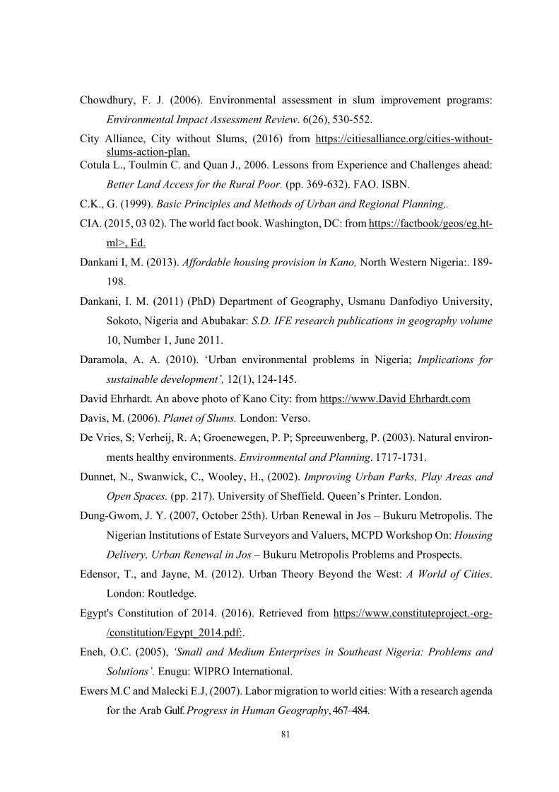
81
Chowdhury, F. J. (2006). Environmental assessment in slum improvement programs:
Environmental Impact Assessment Review. 6(26), 530-552.
City Alliance, City without Slums, (2016) from https://citiesalliance.org/cities-without-slums-action-plan.
Cotula L., Toulmin C. and Quan J., 2006. Lessons from Experience and Challenges ahead:
Better Land Access for the Rural Poor. (pp. 369-632). FAO. ISBN.
C.K., G. (1999). Basic Principles and Methods of Urban and Regional Planning,.
CIA. (2015, 03 02). The world fact book. Washington, DC: from https://factbook/geos/eg.ht-
ml>, Ed.
Dankani I, M. (2013). Affordable housing provision in Kano, North Western Nigeria:. 189-
198.
Dankani, I. M. (2011) (PhD) Department of Geography, Usmanu Danfodiyo University,
Sokoto, Nigeria and Abubakar: S.D. IFE research publications in geography volume
10, Number 1, June 2011.
Daramola, A. A. (2010). ‘Urban environmental problems in Nigeria; Implications for
sustainable development’, 12(1), 124-145.
David Ehrhardt. An above photo of Kano City: from https://www.David Ehrhardt.com
Davis, M. (2006). Planet of Slums. London: Verso.
De Vries, S; Verheij, R. A; Groenewegen, P. P; Spreeuwenberg, P. (2003). Natural environ-
ments healthy environments. Environmental and Planning. 1717-1731.
Dunnet, N., Swanwick, C., Wooley, H., (2002). Improving Urban Parks, Play Areas and
Open Spaces. (pp. 217). University of Sheffield. Queen’s Printer. London.
Dung-Gwom, J. Y. (2007, October 25th). Urban Renewal in Jos – Bukuru Metropolis. The
Nigerian Institutions of Estate Surveyors and Valuers, MCPD Workshop On: Housing
Delivery, Urban Renewal in Jos – Bukuru Metropolis Problems and Prospects.
Edensor, T., and Jayne, M. (2012). Urban Theory Beyond the West: A World of Cities.
London: Routledge.
Egypt's Constitution of 2014. (2016). Retrieved from https://www.constituteproject.-org-
/constitution/Egypt_2014.pdf:.
Eneh, O.C. (2005), ‘Small and Medium Enterprises in Southeast Nigeria: Problems and
Solutions’. Enugu: WIPRO International.
Ewers M.C and Malecki E.J, (2007). Labor migration to world cities: With a research agenda
for the Arab Gulf. Progress in Human Geography, 467–484.

82
Fekade W. (2000). Deficits of formal urban land management and informal responses under
rapid urban growth,. 127-150.
Fincher, R. and Iveson, K. (2008), Planning and Diversity in the City; Vicki-Ann Ware,
Hellene Gronda and Laura Vitis (2010), AHURI Research Synthesis Service:
Addressing locational disadvantage effectively; Mitlin, D. and Satterthwaite, D.
(2013), Urban Poverty in the Global South.
Filani, M.O. (1987): The Urban Poor in Nigeria, Makinwa P.K. & O.A. Ozo (Eds.), Ibadan:
“Accessibility and Urban Poverty in Nigeria”. Evan Brothers (Nigeria) Publishers
Ltd. 128-138.
Fiori, J. (2000). Urban poverty alleviation through environmental upgrading in rio de
janeiro: Favela bairro. London:. Filani, M.O. (1987): “Accessibility and Urban
Poverty in Nigeria” The Urban Poor in Nigeria, Makinwa P.K. & O.A. Ozo (Eds.),
Ibadan: Evan Brothers (Nigeria) Publishers Ltd. 128-138.
Flanagan, G. a. (1979). Urbanisation and Social Change in West Africa.
Fox, S. (2012). Urbanization as a global historical process: Teory and evidence from Sub-
Saharan Africa. Population and Development Review, 285-310.
Frediani, A. A. (2009). The World Bank, Turner and Sen-Freedom in the Urban Arena.
FRN. (2010). The National Bureau of Statistics, Abuja. Nigerian Poverty Profile Report.
FRN. (2013). Nigeria over 167million population: Implications and Challenges. National
Population Commission, Abuja.
Gelder, V. (2007). Feeling and thinking: Quantifying the relationship between perceived
tenure security and housing improvement in an informal neighbourhood in Buenos
Aires. Elsevier, 219-231.
George. (2010). Challenges of Lagos as a Mega-City (2).
George, C. K. (1999). Basic Principles and Methods of Urban and Regional Planning.
Gidlöf Gunnarsson, & Öhrström., (2007). Published in International journal of
environmental research and public health.
Grahn, P. & Stigsdotter, A.U. (2003). Landscape planning and stress. Urban Forestry &
Urban Greening. (2), 1-18.
Groening, G. & Bulmahn, J.W. (1989). Changes in The Philosophy of Garden Architecture
in the 20th Century and Their Impact Upon Social and Spatial Environment. Journal
of Garden History. (2), 53-70.
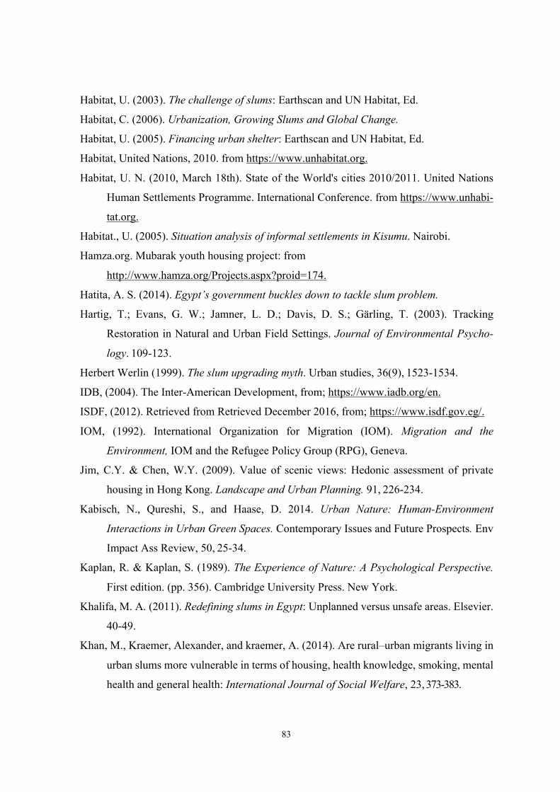
83
Habitat, U. (2003). The challenge of slums: Earthscan and UN Habitat, Ed.
Habitat, C. (2006). Urbanization, Growing Slums and Global Change.
Habitat, U. (2005). Financing urban shelter: Earthscan and UN Habitat, Ed.
Habitat, United Nations, 2010. from https://www.unhabitat.org.
Habitat, U. N. (2010, March 18th). State of the World's cities 2010/2011. United Nations
Human Settlements Programme. International Conference. from https://www.unhabi-
tat.org.
Habitat., U. (2005). Situation analysis of informal settlements in Kisumu. Nairobi.
Hamza.org. Mubarak youth housing project: from
http://www.hamza.org/Projects.aspx?proid=174.
Hatita, A. S. (2014). Egypt’s government buckles down to tackle slum problem.
Hartig, T.; Evans, G. W.; Jamner, L. D.; Davis, D. S.; Gärling, T. (2003). Tracking
Restoration in Natural and Urban Field Settings. Journal of Environmental Psycho-
logy. 109-123.
Herbert Werlin (1999). The slum upgrading myth. Urban studies, 36(9), 1523-1534.
IDB, (2004). The Inter-American Development, from; https://www.iadb.org/en.
ISDF, (2012). Retrieved from Retrieved December 2016, from; https://www.isdf.gov.eg/.
IOM, (1992). International Organization for Migration (IOM). Migration and the
Environment, IOM and the Refugee Policy Group (RPG), Geneva.
Jim, C.Y. & Chen, W.Y. (2009). Value of scenic views: Hedonic assessment of private
housing in Hong Kong. Landscape and Urban Planning. 91, 226-234.
Kabisch, N., Qureshi, S., and Haase, D. 2014. Urban Nature: Human-Environment
Interactions in Urban Green Spaces. Contemporary Issues and Future Prospects. Env
Impact Ass Review, 50, 25-34.
Kaplan, R. & Kaplan, S. (1989). The Experience of Nature: A Psychological Perspective.
First edition. (pp. 356). Cambridge University Press. New York.
Khalifa, M. A. (2011). Redefining slums in Egypt: Unplanned versus unsafe areas. Elsevier.
40-49.
Khan, M., Kraemer, Alexander, and kraemer, A. (2014). Are rural–urban migrants living in
urban slums more vulnerable in terms of housing, health knowledge, smoking, mental
health and general health: International Journal of Social Welfare, 23, 373-383.
84
Kironde, J. L. (2006). The regulatory framework, unplanned development and urban
poverty: 23(4), 460-472.
Kissick, D. e. (2006). Housing for All, Essential to Economic, Social and Civic Develop-
ment. 11-13.
Larkham, P.J. (2002) Consolidated Urban Morphology Reading List. Available at
http://www. urbanform.org/bibliography.html.
Lawton, J. (2007). The Urban Environment. Summary of the Royal Commission on
Environmental Pollution’s report. Twenty-sixth report. (pp. 237). HMSO. London.
Loring, W.C. (1956): “Housing Characteristics and Social Disorganisation”. Journal of
Social Problems, 3, 160-168.
Lynch, K., Binns, T., & Olofin, E. (2001). Urban agriculture under threat: The land security
question in Kano, Nigeria. Cities, 18(3), 159-171.
Maas, J.; Verheij, R. A.; Groenewegen, P. P.; De Vries; S., Spreeuwenberg, P. (2006). Green
space, urbanity, and health: how strong is the relation. Journal of Epidemiology
Community Health. 60, 587-592.
Mabogunje, A. (1990). Urban Planning and the Post-Colonial State in Africa. 121-203.
Mabogunje, A. L. (1968). Urbanization in Nigeria. 46-48.
Magalhães, F. (2012). Slum upgrading: Lessons learned from Brazil. New York: Inter-
American Development Bank, Felipe Herrera Library.
Marshall, S. (2011) Urban Coding and Planning. Abingdon: Routledge.
McKinsey Global Institute (2014), A blueprint for addressing the global affordable housing
challenge.
McCormack, G. R.; Rock, M.; Toohey, A. M.; Hignell, D. (2010). Characteristics of urban
parks associated with park use and physical activity: A review of qualitative research.
Health & Place. 16(4), 712-726.
MHUUC, (2001). Shelter programmes and City Development Strategies in Egypt. Ministry
of Housing, Utilities and Urban Communities. Istanbul: Thematic Committee.
MHUUD, (2008, March). A comprehensive strategy of informal settlements upgrading: The
national program of upgrading informal settlements by 2020. Presentations from
international.
Mayo, S.K., & Angel, S. (1993). Housing: enabling markets to work; with technical
supplements. Washington, DC: World Bank.
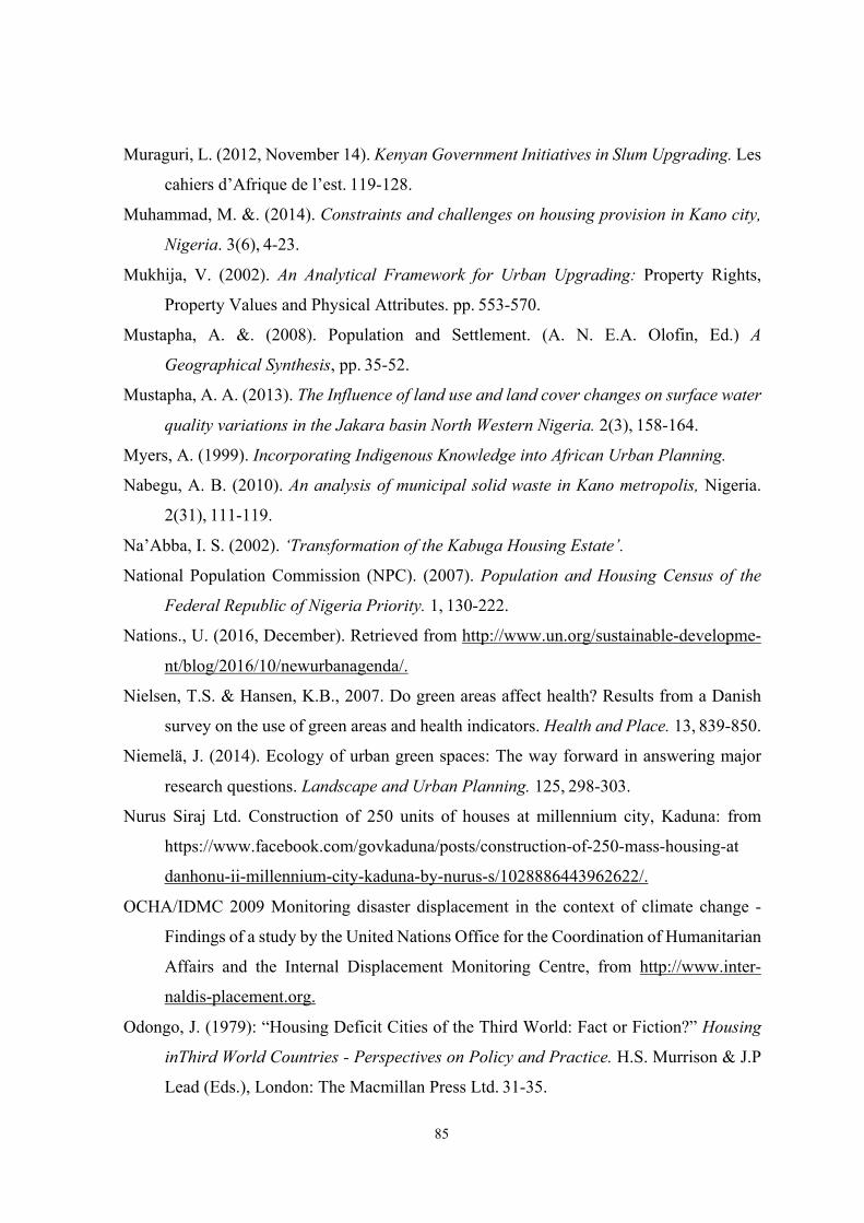
85
Muraguri, L. (2012, November 14). Kenyan Government Initiatives in Slum Upgrading. Les
cahiers d’Afrique de l’est. 119-128.
Muhammad, M. &. (2014). Constraints and challenges on housing provision in Kano city,
Nigeria. 3(6), 4-23.
Mukhija, V. (2002). An Analytical Framework for Urban Upgrading: Property Rights,
Property Values and Physical Attributes. pp. 553-570.
Mustapha, A. &. (2008). Population and Settlement. (A. N. E.A. Olofin, Ed.) A
Geographical Synthesis, pp. 35-52.
Mustapha, A. A. (2013). The Influence of land use and land cover changes on surface water
quality variations in the Jakara basin North Western Nigeria. 2(3), 158-164.
Myers, A. (1999). Incorporating Indigenous Knowledge into African Urban Planning.
Nabegu, A. B. (2010). An analysis of municipal solid waste in Kano metropolis, Nigeria.
2(31), 111-119.
Na’Abba, I. S. (2002). ‘Transformation of the Kabuga Housing Estate’.
National Population Commission (NPC). (2007). Population and Housing Census of the
Federal Republic of Nigeria Priority. 1, 130-222.
Nations., U. (2016, December). Retrieved from http://www.un.org/sustainable-developme-
nt/blog/2016/10/newurbanagenda/.
Nielsen, T.S. & Hansen, K.B., 2007. Do green areas affect health? Results from a Danish
survey on the use of green areas and health indicators. Health and Place. 13, 839-850.
Niemelä, J. (2014). Ecology of urban green spaces: The way forward in answering major
research questions. Landscape and Urban Planning. 125, 298-303.
Nurus Siraj Ltd. Construction of 250 units of houses at millennium city, Kaduna: from
https://www.facebook.com/govkaduna/posts/construction-of-250-mass-housing-at
danhonu-ii-millennium-city-kaduna-by-nurus-s/1028886443962622/.
OCHA/IDMC 2009 Monitoring disaster displacement in the context of climate change -
Findings of a study by the United Nations Office for the Coordination of Humanitarian
Affairs and the Internal Displacement Monitoring Centre, from http://www.inter-
naldis-placement.org.
Odongo, J. (1979): “Housing Deficit Cities of the Third World: Fact or Fiction?” Housing
inThird World Countries - Perspectives on Policy and Practice. H.S. Murrison & J.P
Lead (Eds.), London: The Macmillan Press Ltd. 31-35.
86
Olanrewaju, D. O. (2004). Town Planning. A Veritable Means for Poverty Reduction (2004,
October 26th).
Omole, F. (2010). “An Assessment of Housing Condition and Socio-Economic Life Styles of
Slum Dwellers in Akure, Nigeria”,. 273-290.
Omole, F. K. (2000). Urban renewal process issues and strategies, Lagos, Nigeria: Concept
Books and Publication Company Nig. Ltd.
Opeyemi, M.K., Olabode, M. O., Olalekan, K. B., & Omolola, A. O. (2012). Urban slums
as spatial manifestations of urbanization in Sub-Saharan Africa: A case study of
Ajegunle slum settlement, Lagos. Nigeria. Developing Country Studies, 2(11), 1-10.
Özgüner, H. (2003). İnsan doğa ilişkilerinin gelişimi ve peyzaj tasarımında doğal stilin 20.
yüzyılda önem kazanmasının nedenleri. S.D.Ü. Orman Fakültesi Dergisi. 1, 43-54.
Panoramas. Telling the story of the favelas through art and literature: from
https://www.panoramas.pitt.edu/art-and-culture/telling-story-favelas-through-art-
and-literature
Payne, G. K. (1977). Urban Housing in the Third World, Boston: Routledge and Kegan Paul.
Payne, G & Majale, M (2004), The Urban Housing Manual: Making Regulatory
Frameworks Work for the Poor, London, Earthscan.
Pieterse, E. (2011). Housing the Poor in African Cities; Eviction: Alternatives to the
destruction of urban poor communities. Kenya: United Nations Human Settlements
Programme.
Project for Public Spaces (2000). How to Turn a Place Around: A Handbook for Creating
Successful Public Places. (pp. 125). Project for Public Spaces Inc. New York.
Qin, J.; Zhou, X.; Sun, C.; Lian, Z. (2013) Influence of green spaces on environmental
satisfaction and physiological status of urban residents. Urban Forestry & Urban
Greening. 12(4), 490-497.
Rapoport, Amos. (1988). “Spontaneous settlements as vernacular design” in Patton, C.
(1988). Spontaneous shelter: International perspectives and prospects, Philadelphia:
Temple University Press. 51-77.
Rohde C. L. E. & Kendle A. D. (1994). Human Well-Being, Natural Landscapes and Wild-
life in Urban Areas a Review.
Runkel, C. (2009, January). Diploma Thesis the Case of Cairo. Berlin, Germany: The Role
of Urban Land Titling in Slum Improvement.
87
SERAC. (2006). Pushing Out the Poor: Forced Evictions under the Abuja Master Plan. 28-
29.
Schipperijn, J.; Stigsdotter, A.U.; Randrup, T. B.; Troelsen, J. (2010). Influences on The Use
of Urban Green Space-A Case Study in Odense. Denmark. Urban Forestry & Urban
Greening. 9, 25-32.
Schorr; A.L (1964) Slums and Social Insecurity; London: Thomas Nelson.
Scirp.org. Kano state map, Nigeria: from
https://www.scirp.org/journal/paperinformation.aspx?paperid=80179
Shankardass. (2006). Poverty and slums in India: Impact of Changing economic landscape.
17-69.
Sims, D. (2008). Urban Sector Update. World Bank.
Sims D. (2011). Understanding Cairo: The logic of a city out of control. Cairo.
Soares, F. S. (2005). Washington, D.C: The Socio-Economic Impact of Favela-Bairro:.
Soliman, A.M., (2011). The Egyptian Episode of Self-Build Housing,. (H. International., Ed).
Srivastava A, and Snight R. C, (1996). Slums and associated problems: A case study of Bhi-
lai, an industrial city. International Journal of Environmental Studies, 50, 51- 60.
State, G. O. (2008). Four year strategic plan for; Urban development and housing in Plateau
State. Jos, Nigeria.
Steering Committee on Urbanization, P. C. (2011). Working group on urban poverty, slums,
and serivce delivery system.
Stokoiks, D; M. Rall; & J. Schopler Eds. (1973): “Physical, Social, and Personal Determi-
nants of the Perception of Crowding” Environmental and Behaviour, 5, 87-15.
Suditu, B 2012, Urban sprawl the legal context and territorial practices in Romania, ̕ Human
Geographies: Journal of Studies and Research in Human Geography, (4(2), 74-77).
Sugiyama, T.; Francis, J.; Middleton, N. J.; Owen, N; Giles-Corti, B. (2010). Associations
Between Recreational Walking and Attractiveness, Size, and Proximity of Neigh-
borhood Open Spaces. American Journal of Public Health. 100:(9), 1752-1757.
Syrjänen, R. (2008). UN-Habitat and the Kenya Slum Upgrading Programme - Strategy
Document. Nairobi: United Nations Human Settlements Programme.
Tadamun. (2014, September). Coming Up Short: Egyptian Government Approaches to
Informal Areas. Cairo, Egypt, Egypt.
88
Takano, T.; Nakamura, K.; Watanabe, M. (2002). Urban Residential Environments and
Senior Citizens’ Longevity in Mega–City Areas: The Importance of Walk–Able Green
Space. Journal of Epidemiology and Community Health. 56(12), 913–916.
Tapela, T. (1988). Aspects of the growth and structure of pre-colonial african towns: 11(1),
20-21. O. N. Zimbabwe, Ed. (1988, March).
Tester, K. (2012). A cations and Land Tenure Insecurity in Sub- saharan African slums.
Thisdaylive.com. Flood to assess the level of damage in Kano from: https://www.thisdayliv-
e.com-/index.php/2018/08/30/emergency-relief-agencyassesses-impact-of-flood-in-
8-kano-lgas/.
Thompson, C.W., (2002), Urban open spaces in the 21st century. Landscape and Urban
Planning, 60(2), 59-72.
Tsenkova, S 2010, ̒The Phenomenon of Informal Settle- ments in Post-Socialist Cities:
Factors and Patterns of Diversity̕, Urban Challenge. 21(2), 73-84.
Tovrov, D. (2011). 5 Biggest slums in Africa. International Business Times.
Tulier, M. (2011). Slum upgrading in rio de janeiro: Favela Bairro.
Ukoha, O. M., & Beamish, J. O. (1997). Assessment of residents' satisfaction with public
housing in Abuja, Nigeria. Habitat International, 21(4), 445-460.
Ullah, A.A. (2004). Bright city lights and slums of Dhaka city: Determinants of rural-urban
migration in Bangladesh. Migration Letters,1, 26-41.
Ulrich, R. S.; Simons, R. F.; Losito, B. D.; Fiorito, E.; Miles, M. A.; Zelson, M. (1991).
Stress Recovery During Exposure to Natural and Urban Environments: Journal of
Environmental Psychology. 11, 201-230.
Ulrich, R.S. (2006). Evidence-Based Health-Care Architecture. Lancet. 368, 38-39.
UNDP, U. N. (2004). Municipal Solid Waste Management in Developing Countries.
UNDP, INP. (2004). Choosing decentralization for good governance Cairo. Egypt human
development report 2004: Egypt Institute of National Planning.
UN-Habitat, (2003). The challenge of slums. Nairobi, Kenya:
UN-Habitat, (2006). The millennium development goals and urban sustainability.
UN-HABITAT. (2006). The State of the World’s Cities Report 2006/2007-30 Years of
Shaping the Habitat Agenda, Earth-scan,. 22-23.
UN-Habitat. (2007). What are slums and why do they exist? Twenty first session of the
Governing Council, April 16-20, Nairobi, Kenya.
89
UN-Habitat. (2008). Harmonious cities. U. N.-m. Programme., Ed.
UN-Habitat. (2008). State of the World's cities. 2006/07.
UN-Habitat. (2008). “Housing and Urban Upgrading in Yantai, China”,.
UN-Habitat (2008). The State of the World’s Cities 2008/09; J. Herrera and others (2012),
Informal Sector and Informal Employment, Women in Informal Employment.
UN-Habitat (2009, 2011, 2013), The State of the World’s Cities Report.
UN-Habitat (2011), The State of the World’s Cities Report 2010/11.
UN-Habitat (2012), The State of Arab Cities Report 2012.
UN-Habitat (2013), Streets as Public Spaces and Drivers of Urban Prosperity.
UN-Habitat (2013), The State of the World Cities Report 2012/13.
UN-Habitat (2015), El Estado de las Ciudades Colombianas.
UN-Habitat, Business Dictionary, UN. August 27, (2013). From: https://borgenproject.or-
g/slums-exist/.
UN-Habitat. (2016). Retrieved from https://habitat3.org/the-new-urban-agenda.
ISESCO, (2013). Islamic Educational, Scientific and Cultural Organization. Kano the
Islamic Culture Capital for the African region.
Van den Berg, A. E.; Maas, J.; Verheij, R. A.; Groenewegen, P. P. (2010). Green space as
a buffer between stressful life events and health. Social Science & Medicine. 70:(8),
1203-1210.
Venard, J. L. (1995). Urban Planning and Environment in Sub-Saharan Africa.
Weebly. Favela Bairro project; Developing solutions Rio de Janeiro, Brazil: from
http://developingsolutions.weebly.com/favela-bairro-project.html
Wheater, C.P.; Potts, E.; Shaw, E.M.; Perkins, C.; Smith, H.; Casstles, H.; Cook, P.A.;
Woolley, H. (2003). Urban Open Spaces. (pp. 208). Spon Press. London.
Woolley, H. (2003). Urban Open Spaces. (pp. 209). Spon Press. London.
Wright, H. E. (2011). An Examination of the Impacts of Urbanization on Green Space
Access and Water Resources: A Developed and Developing World Perspective. (pp.
305). Doctor of Philosophy. Wendel University of South Florida. Florida.