Embed Size (px)
Citation preview
ARTICLE IN PRESS
0032-0633/$ - se
doi:10.1016/j.ps
�CorrespondE-mail addr
(R. Kuzmin), m
[email protected] at: Un2Tel.: +49 30
Please cite thi
Planetary and Space Science ] (]]]]) ]]]–]]]
www.elsevier.com/locate/pss
The Circum-Hellas Volcanic Province, Mars: Overview
David A. Williamsa,�, Ronald Greeleya, Robin L. Fergasona,1, Ruslan Kuzminb,Thomas B. McCordc, Jean-Phillipe Combec, James W. Head IIId, Long Xiaoa,e,
Leon Manfredia, Franc-ois Pouletf, Patrick Pinetg, David Baratouxg, Jeffrey J. Plauth,Jouko Raitalai, Gerhard Neukumj,2, the HRSC Co-Investigator Team
aSchool of Earth and Space Exploration, Arizona State University, Box 871404, Tempe, AZ 85287-1404, USAbVernadsky Institute, Russian Academy of Sciences, Kosygin Street 19, Moscow 117975, GSP-1, Russia
cThe Bear Fight Center, 22 Fiddler’s Road, Box 667, Winthrop, WA 98862-667, USAdDepartment of Geological Sciences, Brown University, Providence, RI 02912, USA
eFaculty of Earth Sciences, China University of Geosciences, 388 Rumo Rd., Hongshan Dist., Wuhan 430074, ChinafInstitut d’Astrophysique Spatiale, Batiment 121, Universite Paris-Sud, 91405 Orsay Cedex, France
gObservatoire Midi-Pyrenees, Laboratoire Dynamique Terrestre et Planetaire, UMR 5562, CNRS, Universite Paul-Sabatier, 14, Avenue Edouard Belin,
31 400 Toulouse, FrancehNASA Jet Propulsion Laboratory, 4800 Oak Grove Drive, Mail Stop 183-501, Pasadena, CA 91109, USA
iAstronomy Division, Department of Physical Sciences, University of Oulu, Oulu, FinlandjFreie Universitaet Berlin, Department of Earth Sciences, Institute of Geosciences, Planetary Sciences and Remote Sensing, Malteserstr. 74-100, Building D,
D-12249 Berlin, Germany
Received 14 April 2008; received in revised form 30 July 2008; accepted 5 August 2008
Abstract
Building on previous studies of volcanoes around the Hellas basin with new studies of imaging (High-Resolution Stereo Camera
(HRSC), Thermal Emission Imaging System (THEMIS), Mars Orbiter Camera (MOC), High-Resolution Imaging Science Experiment
(HiRISE), Context Imager (CTX)), multispectral (HRSC, Observatoire pour la Mineralogie, l’Eau, les Glaces et l’Activite (OMEGA)),
topographic (Mars Orbiter Laser Altimeter (MOLA)) and gravity data, we define a new Martian volcanic province as the Circum-Hellas
Volcanic Province (CHVP). With an area of 42.1million km2, it contains the six oldest central vent volcanoes on Mars, which formed
after the Hellas impact basin, between 4.0 and 3.6Ga. These volcanoes mark a transition from the flood volcanism that formed Malea
Planum �3.8Ga, to localized edifice-building eruptions. The CHVP volcanoes have two general morphologies: (1) shield-like edifices
(Tyrrhena, Hadriaca, and Amphitrites Paterae), and (2) caldera-like depressions surrounded by ridged plains (Peneus, Malea, and
Pityusa Paterae). Positive gravity anomalies are found at Tyrrhena, Hadriaca, and Amphitrites, perhaps indicative of dense magma
bodies below the surface. The lack of positive-relief edifices and weak gravity anomalies at Peneus, Malea, and Pityusa suggest a
fundamental difference in their formation, styles of eruption, and/or compositions. The northernmost volcanoes, the �3.7–3.9Ga
Tyrrhena and Hadriaca Paterae, have low slopes, well-channeled flanks, and smooth caldera floors (at tens of meters/pixel scale),
indicative of volcanoes formed from poorly consolidated pyroclastic deposits that have been modified by fluvial and aeolian erosion and
deposition. The �3.6Ga Amphitrites Patera also has a well-channeled flank, but it and the �3.8Ga Peneus Patera are dominated by
scalloped and pitted terrain, pedestal and ejecta flow craters, and a general ‘softened’ appearance. This morphology is indicative not only
of surface materials subjected to periglacial processes involving water ice, but also of a surface composed of easily eroded materials such
as ash and dust. The southernmost volcanoes, the �3.8Ga Malea and Pityusa Paterae, have no channeled flanks, no scalloped and pitted
terrain, and lack the ‘softened’ appearance of their surfaces, but they do contain pedestal and ejecta flow craters and large, smooth,
e front matter r 2008 Elsevier Ltd. All rights reserved.
s.2008.08.010
ing author. Tel.: +1480 965 7029; fax: +1 480 965 8102.
esses: [email protected] (D.A. Williams), [email protected] (R. Greeley), [email protected] (R.L. Fergason), [email protected]
[email protected] (T.B. McCord), [email protected] (J.-P. Combe), [email protected] (J.W. Head III),
du.cn (L. Xiao), [email protected] (L. Manfredi), [email protected] (F. Poulet), [email protected] (P. Pinet),
mip.fr (D. Baratoux), [email protected] (J.J. Plaut), [email protected] (J. Raitala), [email protected] (G. Neukum).
ited States Geological Survey, Astrogeology Research Program, 2255 N. Gemini Drive, Flagstaff, AZ 86001, USA.
83870 579.
s article as: , The Circum-Hellas Volcanic Province, Mars: Overview. Planet. Space Sci. (2008), doi:10.1016/j.pss.2008.08.010
ARTICLE IN PRESSD.A. Williams et al. / Planetary and Space Science ] (]]]]) ]]]–]]]2
bright plateaus in their central depressions. This morphology is indicative of a surface with not only a high water ice content, but also a
more consolidated material that is less susceptible to degradation (relative to the other four volcanoes). We suggest that Malea and
Pityusa (and possibly Peneus) Paterae are Martian equivalents to Earth’s giant calderas (e.g., Yellowstone, Long Valley) that erupted
large volumes of volcanic materials, and that Malea and Pityusa are probably composed of either lava flows or ignimbrites. HRSC and
OMEGA spectral data indicate that dark gray to slightly red materials (often represented as blue or black pixels in HRSC color images),
found in the patera floors and topographic lows throughout the CHVP, have a basaltic composition. A key issue is whether this dark
material represents concentrations of underlying basaltic material eroded by various processes and exposed by aeolian winnowing, or if
the material was transported from elsewhere on Mars by regional winds. Understanding the provenance of these dark materials may be
the key to understanding the volcanic diversity of the Circum-Hellas Volcanic Province.
r 2008 Elsevier Ltd. All rights reserved.
Keywords: Mars volcanism; Mars express; Remote sensing; Crater statistics
1. Introduction
More than half the surface of Mars is covered byvolcanic deposits, including lava flows and inferredpyroclastic materials, reflecting volcanic activity that hasspanned much of the known history of the planet (seereviews by Greeley and Spudis, 1981; Mouginis-Market al., 1992; Neukum et al., 2004a). In the early 1970s, thefirst successful Mars orbiter, Mariner 9, returned low-resolution images (1–3 km/pixel) that revealed the geologi-cal diversity of the surface, including the presence offeatures near the Hellas impact basin that appeared to bevolcanoes (McCauley et al., 1972; Carr, 1973; Carr et al.,1973; Potter, 1976; Peterson, 1977). These features hadradial patterns of ridges and channels, hints of slightlycircular craters, and relatively low topographic relief. Theterm patera was applied to these and similar features seenon Mars. In planetary nomenclature (http://planetarynames.wr.usgs.gov/jsp/append5.jsp), patera refers to a shallowcrater with a scalloped or complex edge (Strobell andMasursky, 1990). However, in planetary literature forMars, the term also commonly refers to volcanic constructs(e.g., Carr, 1981). The term highland paterae was applied toa category of low-profile volcanoes found mostly in thecratered highlands (Plescia and Saunders, 1979) and is alsocommonly used, especially for the features in the Hellasregion.
As reviewed below, in the years following Mariner 9,geological mapping and many topical investigations wereconducted for the paterae of the Hellas region, which cannow be enhanced substantially by new and better data.Building on this body of work and the insight provided bythe current Mars missions, we propose the formaldesignation of the Circum-Hellas Volcanic Province
(CHVP), shown in Figs. 1a and b.
2. Background
In their geological analysis of the Mariner 9 data,McCauley et al. (1972), Carr (1973), and Carr et al. (1973)recognized the volcanic origins of the features around theHellas basin and summarized the volcanic history of Mars,with ages for these three paterae (later named Tyrrhena,Hadriaca, and Amphitrites) of 3.5–4.0Ga, based on crater
Please cite this article as: , The Circum-Hellas Volcanic Province, Mars: Ov
counts (Carr, 1976). As part of the systemic Marsgeological mapping program (see also Scott and Carr,1978), Potter (1976) analyzed the eastern part of the Hellasbasin and Amphitrites Patera, and noted flow-like patternsthat he suggested were produced by fluid lava flows. Atabout the same time, Peterson (1977) mapped the westernpart of the Hellas basin and identified many of the volcaniccenters, later codified in his prescient paper (Peterson,1978), in which he suggested that the paterae are centeredon ring fractures associated with the Hellas impactstructure (Fig. 1). Later studies by Frey et al. (1991)inferred four rings from a previously unrecognized basin(centered on what is now recognized as Pityusa Patera)with diameters of 600, 1200, 1700, and 2200–2400 km, butthey admitted that some of the features noted as part ofthese rings could also apply to rings of the Hellas basin, assuggested by Peterson (1978). Peterson (1978) also notedthe numerous mare-like wrinkle ridges in the areas aroundthe paterae, and suggested that these could be surfacemanifestations of feeder dikes. Because the paterae havelow topographic relief, Peterson (1978) suggested that theyare composed either of ultramafic lavas, which wereerupted as very low-viscosity, fluid lavas, or as ash-flows,analogous to those of Earth’s Yellowstone volcanic region.In the mid-1970s, the Viking orbiters began returning
images substantially improved over those of Mariner 9,enabling refinements of the ideas proposed earlier (Carr etal., 1977a). For example, Greeley and Spudis (1981)suggested that Tyrrhena and Hadriaca Paterae are multi-stage volcanoes that began as low-profile ash-shields builtfrom explosive eruptions resulting from magma risingthrough water-rich mega-regolith. As near-surface ground-water became less abundant due to depletion or freezing,explosivity diminished, and eruptions evolved into aneffusive phase to form the lava flows inferred near thesummits. Subsequently, the ash deposits were eroded toform the channels on the flanks of the paterae. Later imageanalyses, geologic mapping, and eruption modeling studies(Greeley and Crown, 1990; Crown et al., 1992; Crown andGreeley, 1993, 2007; Wilson and Head, 1994; Gregg et al.,1998; Gregg and Farley, 2006) further elucidated theseprocesses.The Hellas paterae were mapped as part of the post-
Viking global geologic mapping program at a scale of
erview. Planet. Space Sci. (2008), doi:10.1016/j.pss.2008.08.010

ARTICLE IN PRESS
Fig. 1. (a) MOLA shaded relief map of the Circum-Hellas Volcanic Province (CHVP), outlined in black (dashed where inferred), with an area of
42.1million km2. The white circles delineate the calderas of the CHVP volcanoes, and white lines represent their respective flanks (dashed where inferred),
based on our image analyses and comparisons to the geologic maps of Gregg et al. (1998), Leonard and Tanaka (2001), Crown and Greeley (2007), and
Kolb and Tanaka (in review). The black ‘‘rings’’ of the Hellas impact structure are from Peterson (1978), in which he inferred that the formation of Hellas
influenced the formation of the named volcanoes. (b) (Color online) MRO95a gravity anomaly map of Mars, with a blowout of the CHVP (area
approximate to (a)). Strong positive gravity anomalies are present at Tyrrhena (TP), Hadriaca (HP), and Amphitrites Paterae (AP), whereas weaker ones
appear to correlate with Peneus (PP), Malea (MP), and Pityusa Paterae (PityP). We suggest that the strong gravity anomalies could indicate the presence
of solidified, relatively dense mafic magma bodies underneath these volcanoes. Gravity data courtesy of G.A. Neumann, NASA Goddard SFC. Gravity
model MRO95a by Alexander Konopliv, JPL (available at: http://pds-geosciences.wustl.edu/missions/mro/gravity.htm).
D.A. Williams et al. / Planetary and Space Science ] (]]]]) ]]]–]]] 3
1:15M, in which Greeley and Guest (1987) mappedTyrrhena and Hadriaca Paterae and Tanaka and Scott(1987) mapped Amphitrites Patera and the now namedPeneus Patera. Malea and Pityusa Paterae (named later)were mapped as volcanic materials (Pityusa Patera as a‘volcanic patera’), and much of the entire area west–south-west of Hellas, now named Malea Planum, was mappedand interpreted to be composed of various volcanic units,including fluid lava flows and/or pyroclastic flows (Tanakaand Scott, 1987). Later, 1:5M-scale geologic mapping wasdone by Tanaka and Leonard (1995; the published US G.S.map is by Leonard and Tanaka, 2001), in which theystudied the general geology of the Hellas area and
Please cite this article as: , The Circum-Hellas Volcanic Province, Mars: Ov
described both the basin-filling material and MaleaPlanum, including the paterae. Tanaka and Leonard(1995) suggested that the south side of the Hellas basinwas filled with material most likely to be lava flows 41 kmthick, erupted from Malea Planum (MOLA data do show atopography suggestive of flows from Malea Planumflowing into the basin), and later Tanaka et al. (2002)suggested catastrophic erosion of the southern Hellas basinrim occurred because of magmatic intrusion into volatile-rich rocks. Tanaka and Leonard (1995) mapped northernMalea Planum as containing upper-Hesperian to lower-Amazonian pyroclastic flow deposits, heavily dissected bythe fluvial channels of Axius Valles, derived from
erview. Planet. Space Sci. (2008), doi:10.1016/j.pss.2008.08.010
ARTICLE IN PRESSD.A. Williams et al. / Planetary and Space Science ] (]]]]) ]]]–]]]4
Amphitrites and Peneus Paterae, and suggested that thedistinctive caldera of Peneus indicated eruptions of massivevolumes of magma, whereas the less pronounced morphol-ogy of Amphitrites was more indicative of a dissectedshield that erupted lower volumes of magma. They noted a20-km-diameter depression on the west flank of Amphi-trites Patera that they thought might be a collapsed ventstructure. Tanaka and Leonard (1995) analyzed the Hellasbasin rim slopes dissected by Axius Valles, and suggestedthat the presence of a hilly surface reflected degraded lavaflows, lahars, or volcaniclastic materials. In contrast,they mapped southern Malea Planum (i.e., south ofAmphitrites and Peneus Paterae) as dominated by upper-Noachian to lower-Hesperian ridged plains, which theyinterpreted as low-viscosity lava flows from Amphitritesand Peneus.
Crumpler et al. (1996) analyzed calderas on Marsand described Amphitrites and Peneus Paterae based onViking data. They described the radial and concentricpattern of mare-type ridges around Amphitrites andnoted their resemblance to the so-called ‘‘arachnoids’’ onVenus, the category of low-profile volcano first seen inlow-resolution Venera 15/16 images (Barsukov et al., 1986)and later in better detail in Magellan images (Head et al.,1992).
Some of the first Mars Global Surveyor (MGS) dataanalysis of this region was by Head and Pratt (2001a), whocharacterized the topography of the ‘Malea Planumvolcanic province’ based on MOLA data. They foundembayed craters, suggesting flooding by flows, andquantified the elevations of terrain, showing that MaleaPlanum stands some 1000–1500 km above Mars datum,and that Amphitrites is a distinctive shield 1.5 km high andcontains a caldera 300–600m deep, among other measure-ments.
With time, data from the current generation of Marsorbiters began to accumulate over the southern latitudes inthe areas that still are difficult to observe because ofatmospheric conditions, enabling testing of ideas that hadbeen proposed previously. For example, Plescia (2003,2004) used MOLA data and agreed that Amphitrites andPeneus are well-defined calderas based on their topogra-phy, but suggested that the features now called Malea andPityusa Paterae are heavily eroded or buried craters andnot necessarily volcanic vents. He also noted that theregion is heavily mantled, with the terrain showing‘‘scalloped’’ morphologies in MOC images, and that thepaucity of small craters suggests extensive resurfacing.
Most recently, Kolb and Tanaka (in review) completedgeological mapping of the south polar region and identifiedMalea and Pityusa Paterae as volcanoes, although heavilyaltered by other processes. Larson (2007), in an unpub-lished Master’s thesis, conducted a thorough study of thepaterae of Malea Planum using MOLA, MOC, andTHEMIS data, and suggested that Malea and PityusaPaterae might have been intrusive, and could not identifyany lava flow features associated with them.
Please cite this article as: , The Circum-Hellas Volcanic Province, Mars: Ov
In summary, highland paterae appear to be the oldestrecognized volcanoes on Mars that formed in associationwith edifice-building eruptions. Although earlier volcanismis inferred to have occurred on Mars (see e.g., Tanaka etal., 1992) there are no visible morphological indicatorssuch as flows, and the interpretation is based on remote-sensing data that suggest iron and magnesium-richcompositions, such as basalt (McCord et al., 1982; Pinetand Chevrel, 1990; Bandfield et al., 2000). By analogy withlunar lava flows and flood basalts on Earth, the putativeearly Martian basalts are thought to have erupted fromfissures, traces of which have been buried by their ownproducts (i.e., ridged plains). Recent data have revealedevidence for extensive ridges interpreted to be exposeddikes related to flood basalt-like emplacement of the plains(e.g., Head et al., 2006). Thus, in this interpretation,highland paterae may represent a change in the style ofvolcanism on Mars from fissure eruptions (that typicallyinvolve rapid outpourings of large volumes of magma toproduce vast sheets of flood lavas, e.g., Hesperia Planum)to local central vents that involved smaller ‘‘batches’’ ofmagma erupted at lower rates. We test these ideas in thework described below.
3. Data and methods
Image analyses constitute the primary data used in thisstudy, coupled with crater counts, topographic measure-ments, and multispectral analyses, on which details areprovided in appendix. The most complete areal coverage isfrom Mariner 9, Viking Orbiters 1-2, the Mars Express
(MEX) High-Resolution Stereo Camera (HRSC: Neukumet al., 2004b), and the Mars Odyssey (MO) ThermalEmission Imaging System (THEMIS: Christensen et al.,2004). Very high-resolution images of limited coverage areavailable from the MGS Mars Orbiter Camera (MOC:Malin and Edgett, 2001) and the Mars Reconnaissance
Orbiter (MRO) High-Resolution Imaging Science Experi-ment (HiRISE: McEwen et al., 2007) and Context Imager(CTX: Malin et al., 2007). In addition, visible and near-infrared multispectral data at high-spectral resolution areavailable for much of the area from the Mars Express
Observatoire pour la Mineralogie, l’Eau, les Glaces etl’Activite (OMEGA) spectrometer (Bibring et al., 2004).HRSC data are also used as 5-channel multispectral data.It should be noted, however, that images and multispectraldata for geomorphic analyses are often compromised in themore southerly latitudes of Mars by clouds and dust in theatmosphere. Topographic data from the Mars Global
Surveyor Mars Orbiter Laser Altimeter (MOLA: Zuberet al., 1992; Smith et al. 1999, 2001), MGS and MROgravity data (Lemoine et al., 2001; G.A. Neumann, pers.comm., 2008), and subsurface imaging from the MEXMars Advanced Radar for Subsurface and IonosphereSounding (MARSIS: Picardi et al., 2004) were also used inthis study.
erview. Planet. Space Sci. (2008), doi:10.1016/j.pss.2008.08.010
ARTICLE IN PRESS
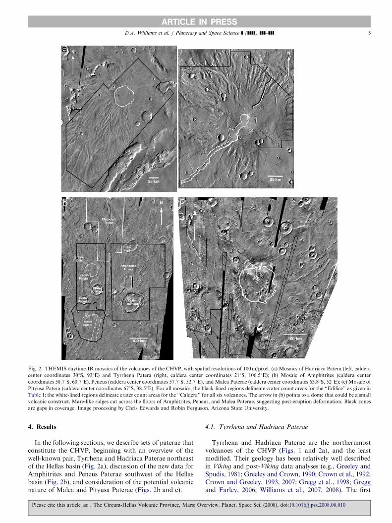
Fig. 2. THEMIS daytime-IR mosaics of the volcanoes of the CHVP, with spatial resolutions of 100m/pixel. (a) Mosaics of Hadriaca Patera (left, caldera
center coordinates 301S, 931E) and Tyrrhena Patera (right, caldera center coordinates 211S, 106.51E); (b) Mosaic of Amphitrites (caldera center
coordinates 58.71S, 60.71E), Peneus (caldera center coordinates 57.71S, 52.71E), and Malea Paterae (caldera center coordinates 63.81S, 521E); (c) Mosaic of
Pityusa Patera (caldera center coordinates 671S, 38.51E). For all mosaics, the black-lined regions delineate crater count areas for the ‘‘Edifice’’ as given in
Table 1; the white-lined regions delineate crater count areas for the ‘‘Caldera’’ for all six volcanoes. The arrow in (b) points to a dome that could be a small
volcanic construct. Mare-like ridges cut across the floors of Amphitrites, Peneus, and Malea Paterae, suggesting post-eruption deformation. Black zones
are gaps in coverage. Image processing by Chris Edwards and Robin Ferguson, Arizona State University.
D.A. Williams et al. / Planetary and Space Science ] (]]]]) ]]]–]]] 5
4. Results
In the following sections, we describe sets of paterae thatconstitute the CHVP, beginning with an overview of thewell-known pair, Tyrrhena and Hadriaca Paterae northeastof the Hellas basin (Fig. 2a), discussion of the new data forAmphitrites and Peneus Paterae southwest of the Hellasbasin (Fig. 2b), and consideration of the potential volcanicnature of Malea and Pityusa Paterae (Figs. 2b and c).
Please cite this article as: , The Circum-Hellas Volcanic Province, Mars: Ov
4.1. Tyrrhena and Hadriaca Paterae
Tyrrhena and Hadriaca Paterae are the northernmostvolcanoes of the CHVP (Figs. 1 and 2a), and the leastmodified. Their geology has been relatively well describedin Viking and post-Viking data analyses (e.g., Greeley andSpudis, 1981; Greeley and Crown, 1990; Crown et al., 1992;Crown and Greeley, 1993, 2007; Gregg et al., 1998; Greggand Farley, 2006; Williams et al., 2007, 2008). The first
erview. Planet. Space Sci. (2008), doi:10.1016/j.pss.2008.08.010
ARTICLE IN PRESSD.A. Williams et al. / Planetary and Space Science ] (]]]]) ]]]–]]]6
volcanic stage to form the constructs of these pateraeappears to have involved eruptions of ash, perhaps drivenby explosions resulting from water–magma interactions, toproduce low-profile, shield-like edifices and large summitcalderas. The volcanoes were then eroded, as evidenced byradial channels separated by mesas. This phase wasfollowed by eruptions of fluid lavas that flooded thecalderas and formed local flows on the flanks of thevolcanoes (Greeley and Crown, 1990; Crown et al., 1992;Crown and Greeley, 1993). Since the cessation of volcan-ism and either concurrent or subsequent fluvial activity, thedominant process acting on Tyrrhena and HadriacaPaterae has been differential aeolian erosion and deposi-tion, as evidenced by bright mantling and dune depositsvisible in MOC images (Williams et al., 2007).
Further studies based on HRSC, MOC, and THEMISimages include crater counts to assign cratering model ages(Williams et al., 2007, 2008) to units defined by the Viking
image-based geological mapping (Gregg et al., 1998;Crown and Greeley, 2007). Both Hadriaca and TyrrhenaPaterae formed �3.7–3.9Ga, after the Hellas impact(�4Ga: Werner and Neukum, 2003; Werner, 2005). Majorvolcanic event(s) occurred on their flanks and calderasthrough �3.3–3.7Ga, and later resurfacing activity byfluvial, volcanic and/or aeolian processes occurred from�3.3 to as recent as 1.1Ga at Hadriaca Patera (Williams etal., 2007) and as recent as 0.8Ga at Tyrrhena Patera(Williams et al., 2008).
For this project, we used THEMIS daytime-IR mosaicsat 100m/pixel spatial resolution as a consistent image baseto perform crater counts to assess the ages of all six pateraein the CHVP (Figs. 2 and 3). The crater counting followedstandard practices (Crater Statistics Analysis Group,1979), and we determined N(1) cratering model agesfollowing the method of Hartmann and Neukum (2001);see also methods discussion in the appendix). Our resultsgive a cratering model age of 3.7Ga for Hadriaca Patera(whole volcano, excluding the caldera: Fig. 3a). This resultis consistent with Williams et al. (2007), who countedsmaller and different areas of the edifice on higher-resolution HRSC nadir images, and found N(1) modelages ranging 3.7–3.9Ga. For Tyrrhena Patera (wholevolcano, excluding the caldera: Fig. 3b), our results givea cratering model age of 3.8Ga. This result is in goodagreement with Williams et al. (2008), who counteddifferent areas of the edifice on HRSC nadir images andfound N(1) cratering model ages of formation ranging3.7–4.0Ga. Given the similarities in cratering model agesresulting from the Hartmann and Neukum (2001) methodapplied to both higher-resolution HRSC images and lower-resolution THEMIS day-IR mosaics, we have greaterconfidence in our crater counts using the THEMIS mosaicsfor the other four volcanoes in the CHVP that have notbeen studied previously with this technique.
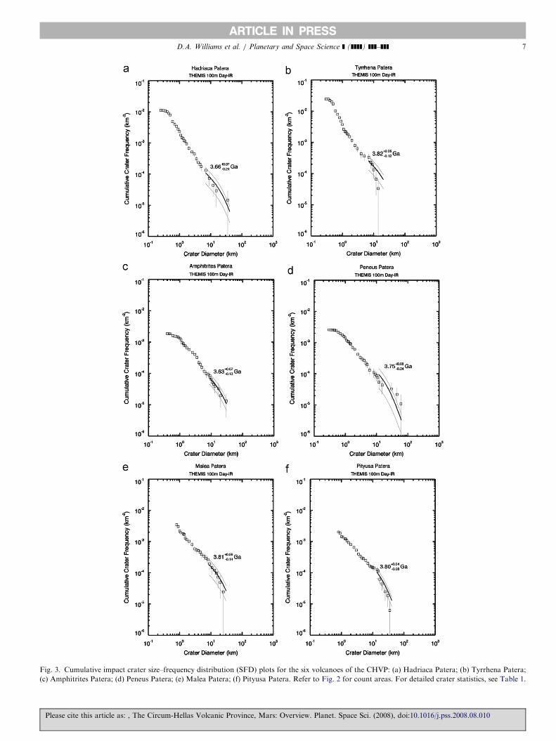
We also used HRSC color images (Fig. 4) to assessvariations in materials composing Hadriaca and TyrrhenaPaterae. The HRSC images show darker areas in topo-
Please cite this article as: , The Circum-Hellas Volcanic Province, Mars: Ov
graphic lows (crater and channel floors) or downslope fromthe summits, and in some cases on the tops of mesas, whichwe interpret as concentrations of basaltic material from theinteriors of the volcanoes exposed by aeolian winnowing,or perhaps produced by glacial or fluvial erosion ofunderlying basalt and concentrated by local or regionalwinds (e.g., Baratoux et al., 2007b). This is consistent withprevious interpretations of dark material observed inHRSC color data as being basaltic in composition(McCord et al., 2007). Alternatively, these darker areascould be basaltic sand or dust deposits transported fromelsewhere on Mars and deposited by aeolian processes,although it is unclear where the long-distance source(s) arelocated. The relative brightness of these volcano flanks isindicative of considerable dust mantling, likely depositedby regional winds around the Hellas basin and attesting tothe dominant role of current aeolian processes on Mars.Finally, we compared MGS (Lemoine et al., 2001) and
MRO gravity data (G.A. Neumann, pers. comm., 2008;gravity model MRO95a by Alexander Konopliv, JPL,available at: http://pds-geosciences.wustl.edu/missions/mro/gravity.htm) for the CHVP region (Fig. 1b). Resultsshow strong positive gravity anomalies correlated withTyrrhena, Hadriaca, and particularly Amphitrites Paterae(Lemoine et al., 2001), and much weaker anomalies forPeneus, Malea, and Pityusa Paterae. Although a compre-hensive analysis of these martian gravity data has not beenperformed, we suggest that these data showing stronggravity anomalies could indicate the presence of relativelydense magma bodies underneath these edifices.
4.2. Amphitrites and Peneus Paterae
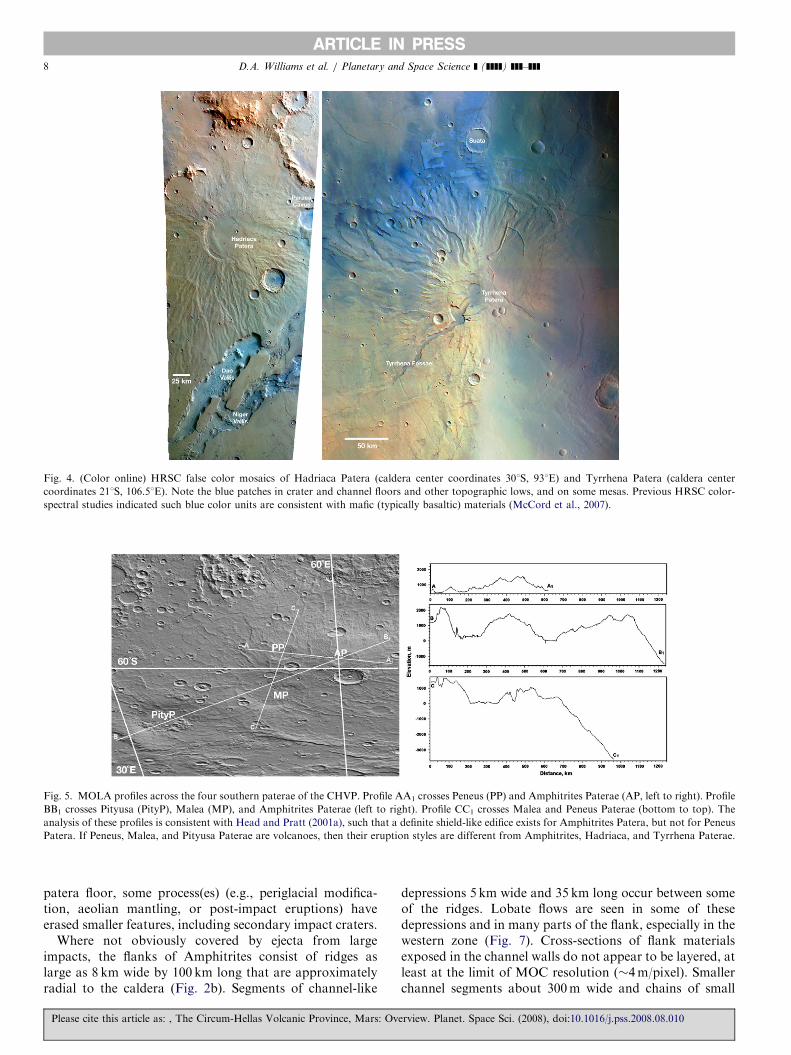
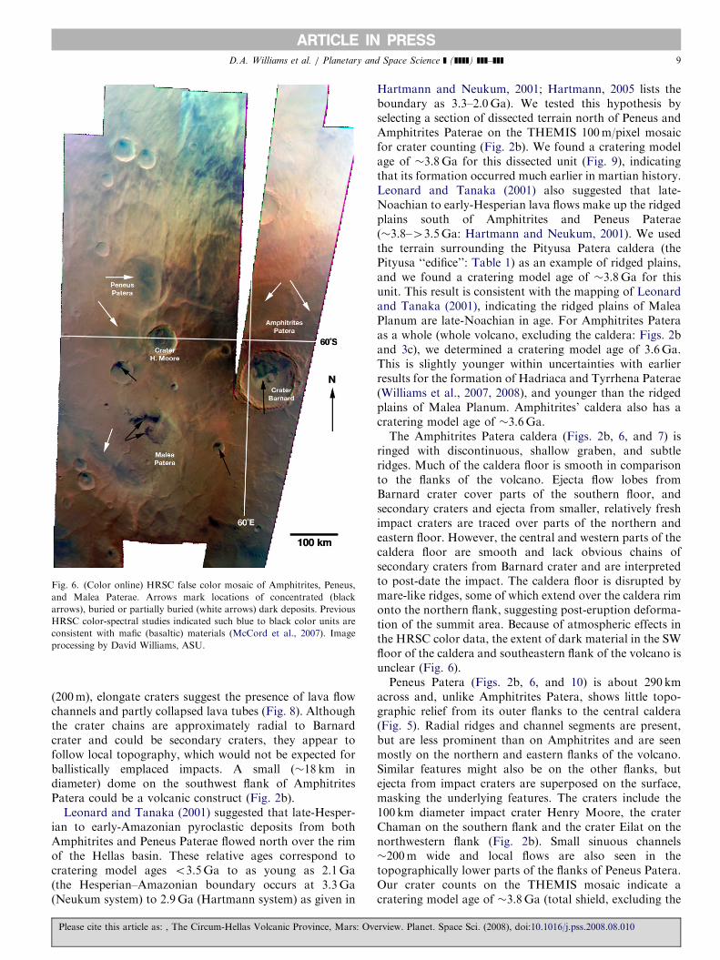
Most of this study focused on post-Viking images andother data to understand the four features in MaleaPlanum interpreted to be volcanoes: Amphitrites, Peneus,Malea, and Pityusa Paterae. In this section we describeAmphitrites and Peneus Paterae. MOC and HiRISEimages and MOLA profiles (Fig. 5) provide tantalizingclues to the origin of these features. However, MOC high-resolution frames (�4m/pixel) are isolated and cover toosmall an area to enable an integrated analysis of thefeatures. HRSC nadir (�12m/pixel) and THEMIS visible(18 or 36m/pixel) images, along with HRSC color (Fig. 6)and THEMIS (Fig. 2b) daytime-IR images, both at 100m/pixel, provide coverage over both features under relativelyclear atmospheric conditions.MOLA profiles (Fig. 5) show that Amphitrites Patera is
about 280 km across and stands 1000–1300m above thesurrounding plains, forming a broad shield-shaped edificesuperposed on older ridged plains of Malea Planum to thesouth. The summit of Amphitrites Patera contains acaldera 112 km in diameter with a floor 300–600m belowthe rim. Much of the surface of Amphitrites is modified byBarnard crater, a 130 km diameter central-ring impactstructure superposed on the southern flank of the volcano.Although ejecta flow lobes from the impact mantle the
erview. Planet. Space Sci. (2008), doi:10.1016/j.pss.2008.08.010
ARTICLE IN PRESS
Fig. 3. Cumulative impact crater size–frequency distribution (SFD) plots for the six volcanoes of the CHVP: (a) Hadriaca Patera; (b) Tyrrhena Patera;
(c) Amphitrites Patera; (d) Peneus Patera; (e) Malea Patera; (f) Pityusa Patera. Refer to Fig. 2 for count areas. For detailed crater statistics, see Table 1.
D.A. Williams et al. / Planetary and Space Science ] (]]]]) ]]]–]]] 7
Please cite this article as: , The Circum-Hellas Volcanic Province, Mars: Overview. Planet. Space Sci. (2008), doi:10.1016/j.pss.2008.08.010
ARTICLE IN PRESS
Fig. 4. (Color online) HRSC false color mosaics of Hadriaca Patera (caldera center coordinates 301S, 931E) and Tyrrhena Patera (caldera center
coordinates 211S, 106.51E). Note the blue patches in crater and channel floors and other topographic lows, and on some mesas. Previous HRSC color-
spectral studies indicated such blue color units are consistent with mafic (typically basaltic) materials (McCord et al., 2007).
Fig. 5. MOLA profiles across the four southern paterae of the CHVP. Profile AA1 crosses Peneus (PP) and Amphitrites Paterae (AP, left to right). Profile
BB1 crosses Pityusa (PityP), Malea (MP), and Amphitrites Paterae (left to right). Profile CC1 crosses Malea and Peneus Paterae (bottom to top). The
analysis of these profiles is consistent with Head and Pratt (2001a), such that a definite shield-like edifice exists for Amphitrites Patera, but not for Peneus
Patera. If Peneus, Malea, and Pityusa Paterae are volcanoes, then their eruption styles are different from Amphitrites, Hadriaca, and Tyrrhena Paterae.
D.A. Williams et al. / Planetary and Space Science ] (]]]]) ]]]–]]]8
patera floor, some process(es) (e.g., periglacial modifica-tion, aeolian mantling, or post-impact eruptions) haveerased smaller features, including secondary impact craters.
Where not obviously covered by ejecta from largeimpacts, the flanks of Amphitrites consist of ridges aslarge as 8 km wide by 100 km long that are approximatelyradial to the caldera (Fig. 2b). Segments of channel-like
Please cite this article as: , The Circum-Hellas Volcanic Province, Mars: Ov
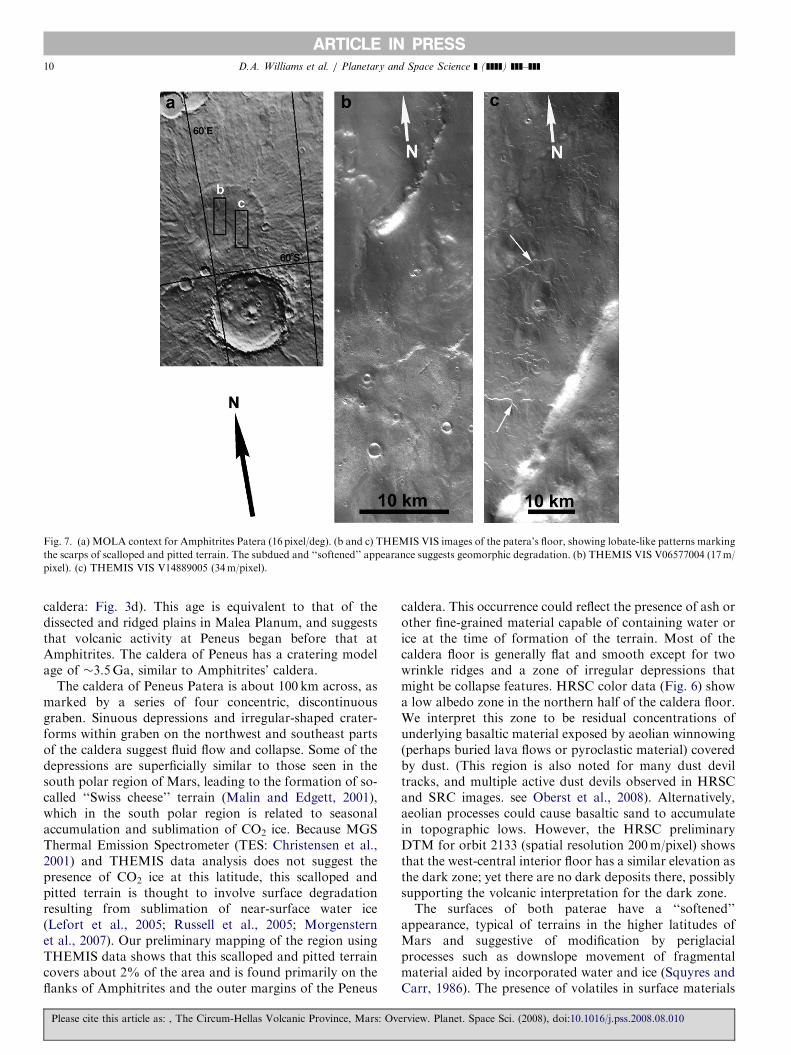
depressions 5 km wide and 35 km long occur between someof the ridges. Lobate flows are seen in some of thesedepressions and in many parts of the flank, especially in thewestern zone (Fig. 7). Cross-sections of flank materialsexposed in the channel walls do not appear to be layered, atleast at the limit of MOC resolution (�4m/pixel). Smallerchannel segments about 300m wide and chains of small
erview. Planet. Space Sci. (2008), doi:10.1016/j.pss.2008.08.010
ARTICLE IN PRESS
Fig. 6. (Color online) HRSC false color mosaic of Amphitrites, Peneus,
and Malea Paterae. Arrows mark locations of concentrated (black
arrows), buried or partially buried (white arrows) dark deposits. Previous
HRSC color-spectral studies indicated such blue to black color units are
consistent with mafic (basaltic) materials (McCord et al., 2007). Image
processing by David Williams, ASU.
D.A. Williams et al. / Planetary and Space Science ] (]]]]) ]]]–]]] 9
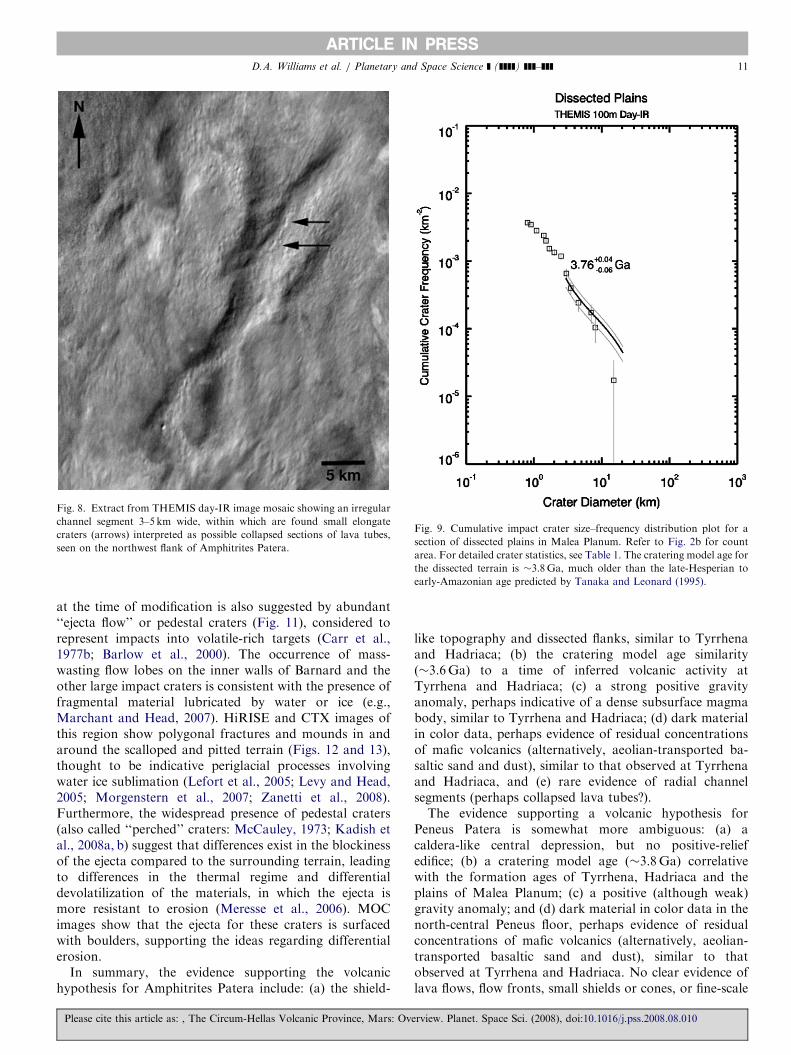
(200m), elongate craters suggest the presence of lava flowchannels and partly collapsed lava tubes (Fig. 8). Althoughthe crater chains are approximately radial to Barnardcrater and could be secondary craters, they appear tofollow local topography, which would not be expected forballistically emplaced impacts. A small (�18 km indiameter) dome on the southwest flank of AmphitritesPatera could be a volcanic construct (Fig. 2b).
Leonard and Tanaka (2001) suggested that late-Hesper-ian to early-Amazonian pyroclastic deposits from bothAmphitrites and Peneus Paterae flowed north over the rimof the Hellas basin. These relative ages correspond tocratering model ages o3.5Ga to as young as 2.1Ga(the Hesperian–Amazonian boundary occurs at 3.3Ga(Neukum system) to 2.9Ga (Hartmann system) as given in
Please cite this article as: , The Circum-Hellas Volcanic Province, Mars: Ov
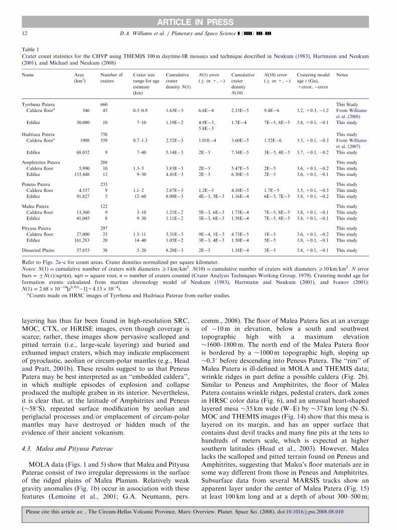
Hartmann and Neukum, 2001; Hartmann, 2005 lists theboundary as 3.3–2.0Ga). We tested this hypothesis byselecting a section of dissected terrain north of Peneus andAmphitrites Paterae on the THEMIS 100m/pixel mosaicfor crater counting (Fig. 2b). We found a cratering modelage of �3.8Ga for this dissected unit (Fig. 9), indicatingthat its formation occurred much earlier in martian history.Leonard and Tanaka (2001) also suggested that late-Noachian to early-Hesperian lava flows make up the ridgedplains south of Amphitrites and Peneus Paterae(�3.8–43.5Ga: Hartmann and Neukum, 2001). We usedthe terrain surrounding the Pityusa Patera caldera (thePityusa ‘‘edifice’’: Table 1) as an example of ridged plains,and we found a cratering model age of �3.8Ga for thisunit. This result is consistent with the mapping of Leonardand Tanaka (2001), indicating the ridged plains of MaleaPlanum are late-Noachian in age. For Amphitrites Pateraas a whole (whole volcano, excluding the caldera: Figs. 2band 3c), we determined a cratering model age of 3.6Ga.This is slightly younger within uncertainties with earlierresults for the formation of Hadriaca and Tyrrhena Paterae(Williams et al., 2007, 2008), and younger than the ridgedplains of Malea Planum. Amphitrites’ caldera also has acratering model age of �3.6Ga.The Amphitrites Patera caldera (Figs. 2b, 6, and 7) is
ringed with discontinuous, shallow graben, and subtleridges. Much of the caldera floor is smooth in comparisonto the flanks of the volcano. Ejecta flow lobes fromBarnard crater cover parts of the southern floor, andsecondary craters and ejecta from smaller, relatively freshimpact craters are traced over parts of the northern andeastern floor. However, the central and western parts of thecaldera floor are smooth and lack obvious chains ofsecondary craters from Barnard crater and are interpretedto post-date the impact. The caldera floor is disrupted bymare-like ridges, some of which extend over the caldera rimonto the northern flank, suggesting post-eruption deforma-tion of the summit area. Because of atmospheric effects inthe HRSC color data, the extent of dark material in the SWfloor of the caldera and southeastern flank of the volcano isunclear (Fig. 6).Peneus Patera (Figs. 2b, 6, and 10) is about 290 km
across and, unlike Amphitrites Patera, shows little topo-graphic relief from its outer flanks to the central caldera(Fig. 5). Radial ridges and channel segments are present,but are less prominent than on Amphitrites and are seenmostly on the northern and eastern flanks of the volcano.Similar features might also be on the other flanks, butejecta from impact craters are superposed on the surface,masking the underlying features. The craters include the100 km diameter impact crater Henry Moore, the craterChaman on the southern flank and the crater Eilat on thenorthwestern flank (Fig. 2b). Small sinuous channels�200m wide and local flows are also seen in thetopographically lower parts of the flanks of Peneus Patera.Our crater counts on the THEMIS mosaic indicate acratering model age of �3.8Ga (total shield, excluding the
erview. Planet. Space Sci. (2008), doi:10.1016/j.pss.2008.08.010
ARTICLE IN PRESS
Fig. 7. (a) MOLA context for Amphitrites Patera (16 pixel/deg). (b and c) THEMIS VIS images of the patera’s floor, showing lobate-like patterns marking
the scarps of scalloped and pitted terrain. The subdued and ‘‘softened’’ appearance suggests geomorphic degradation. (b) THEMIS VIS V06577004 (17m/
pixel). (c) THEMIS VIS V14889005 (34m/pixel).
D.A. Williams et al. / Planetary and Space Science ] (]]]]) ]]]–]]]10
caldera: Fig. 3d). This age is equivalent to that of thedissected and ridged plains in Malea Planum, and suggeststhat volcanic activity at Peneus began before that atAmphitrites. The caldera of Peneus has a cratering modelage of �3.5Ga, similar to Amphitrites’ caldera.
The caldera of Peneus Patera is about 100 km across, asmarked by a series of four concentric, discontinuousgraben. Sinuous depressions and irregular-shaped crater-forms within graben on the northwest and southeast partsof the caldera suggest fluid flow and collapse. Some of thedepressions are superficially similar to those seen in thesouth polar region of Mars, leading to the formation of so-called ‘‘Swiss cheese’’ terrain (Malin and Edgett, 2001),which in the south polar region is related to seasonalaccumulation and sublimation of CO2 ice. Because MGSThermal Emission Spectrometer (TES: Christensen et al.,2001) and THEMIS data analysis does not suggest thepresence of CO2 ice at this latitude, this scalloped andpitted terrain is thought to involve surface degradationresulting from sublimation of near-surface water ice(Lefort et al., 2005; Russell et al., 2005; Morgensternet al., 2007). Our preliminary mapping of the region usingTHEMIS data shows that this scalloped and pitted terraincovers about 2% of the area and is found primarily on theflanks of Amphitrites and the outer margins of the Peneus
Please cite this article as: , The Circum-Hellas Volcanic Province, Mars: Ov
caldera. This occurrence could reflect the presence of ash orother fine-grained material capable of containing water orice at the time of formation of the terrain. Most of thecaldera floor is generally flat and smooth except for twowrinkle ridges and a zone of irregular depressions thatmight be collapse features. HRSC color data (Fig. 6) showa low albedo zone in the northern half of the caldera floor.We interpret this zone to be residual concentrations ofunderlying basaltic material exposed by aeolian winnowing(perhaps buried lava flows or pyroclastic material) coveredby dust. (This region is also noted for many dust deviltracks, and multiple active dust devils observed in HRSCand SRC images. see Oberst et al., 2008). Alternatively,aeolian processes could cause basaltic sand to accumulatein topographic lows. However, the HRSC preliminaryDTM for orbit 2133 (spatial resolution 200m/pixel) showsthat the west-central interior floor has a similar elevation asthe dark zone; yet there are no dark deposits there, possiblysupporting the volcanic interpretation for the dark zone.The surfaces of both paterae have a ‘‘softened’’
appearance, typical of terrains in the higher latitudes ofMars and suggestive of modification by periglacialprocesses such as downslope movement of fragmentalmaterial aided by incorporated water and ice (Squyres andCarr, 1986). The presence of volatiles in surface materials
erview. Planet. Space Sci. (2008), doi:10.1016/j.pss.2008.08.010
ARTICLE IN PRESS
Fig. 8. Extract from THEMIS day-IR image mosaic showing an irregular
channel segment 3–5 km wide, within which are found small elongate
craters (arrows) interpreted as possible collapsed sections of lava tubes,
seen on the northwest flank of Amphitrites Patera.
Fig. 9. Cumulative impact crater size–frequency distribution plot for a
section of dissected plains in Malea Planum. Refer to Fig. 2b for count
area. For detailed crater statistics, see Table 1. The cratering model age for
the dissected terrain is �3.8Ga, much older than the late-Hesperian to
early-Amazonian age predicted by Tanaka and Leonard (1995).
D.A. Williams et al. / Planetary and Space Science ] (]]]]) ]]]–]]] 11
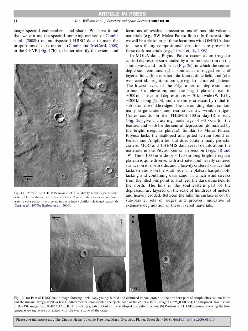
at the time of modification is also suggested by abundant‘‘ejecta flow’’ or pedestal craters (Fig. 11), considered torepresent impacts into volatile-rich targets (Carr et al.,1977b; Barlow et al., 2000). The occurrence of mass-wasting flow lobes on the inner walls of Barnard and theother large impact craters is consistent with the presence offragmental material lubricated by water or ice (e.g.,Marchant and Head, 2007). HiRISE and CTX images ofthis region show polygonal fractures and mounds in andaround the scalloped and pitted terrain (Figs. 12 and 13),thought to be indicative periglacial processes involvingwater ice sublimation (Lefort et al., 2005; Levy and Head,2005; Morgenstern et al., 2007; Zanetti et al., 2008).Furthermore, the widespread presence of pedestal craters(also called ‘‘perched’’ craters: McCauley, 1973; Kadish etal., 2008a, b) suggest that differences exist in the blockinessof the ejecta compared to the surrounding terrain, leadingto differences in the thermal regime and differentialdevolatilization of the materials, in which the ejecta ismore resistant to erosion (Meresse et al., 2006). MOCimages show that the ejecta for these craters is surfacedwith boulders, supporting the ideas regarding differentialerosion.
In summary, the evidence supporting the volcanichypothesis for Amphitrites Patera include: (a) the shield-
Please cite this article as: , The Circum-Hellas Volcanic Province, Mars: Ov
like topography and dissected flanks, similar to Tyrrhenaand Hadriaca; (b) the cratering model age similarity(�3.6Ga) to a time of inferred volcanic activity atTyrrhena and Hadriaca; (c) a strong positive gravityanomaly, perhaps indicative of a dense subsurface magmabody, similar to Tyrrhena and Hadriaca; (d) dark materialin color data, perhaps evidence of residual concentrationsof mafic volcanics (alternatively, aeolian-transported ba-saltic sand and dust), similar to that observed at Tyrrhenaand Hadriaca, and (e) rare evidence of radial channelsegments (perhaps collapsed lava tubes?).The evidence supporting a volcanic hypothesis for
Peneus Patera is somewhat more ambiguous: (a) acaldera-like central depression, but no positive-reliefedifice; (b) a cratering model age (�3.8Ga) correlativewith the formation ages of Tyrrhena, Hadriaca and theplains of Malea Planum; (c) a positive (although weak)gravity anomaly; and (d) dark material in color data in thenorth-central Peneus floor, perhaps evidence of residualconcentrations of mafic volcanics (alternatively, aeolian-transported basaltic sand and dust), similar to thatobserved at Tyrrhena and Hadriaca. No clear evidence oflava flows, flow fronts, small shields or cones, or fine-scale
erview. Planet. Space Sci. (2008), doi:10.1016/j.pss.2008.08.010
ARTICLE IN PRESS
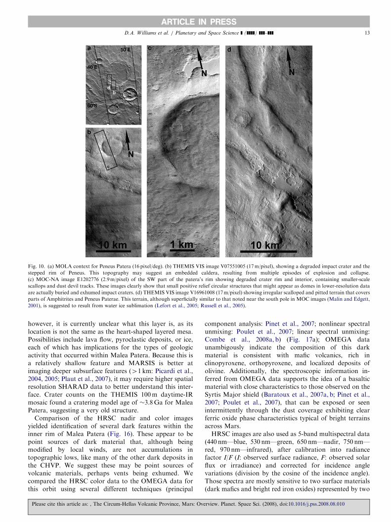
Table 1
Crater count statistics for the CHVP using THEMIS 100m daytime-IR mosaics and technique described in Neukum (1983), Hartmann and Neukum
(2001), and Michael and Neukum (2008)
Name Area
(km2)
Number of
craters
Crater size
range for age
estimate
(km)
Cumulative
crater
density N(1)
N(1) error
(7 or +, �)
Cumulative
crater
density
N(10)
N(10) error
(7 or +, �)
Cratering model
age t (Ga),
+error, �error
Notes
Tyrrhena Patera 660 This Study
Caldera floora 346 45 0.5–0.9 1.63E�3 6.6E�4 2.33E�5 9.4E�6 3.2, +0.3, �1.2 From Williams
et al. (2008)
Edifice 30,080 10 7–10 1.19E�2 4.9E�3,
5.8E�3
1.7E�4 7E�5, 8E�5 3.8, +0.1, �0.1 This study
Hadriaca Patera 758 This study
Caldera floora 1908 559 0.7–1.3 2.52E�3 1.01E�4 3.60E�5 1.52E�6 3.5, +0.1, �0.3 From Williams
et al. (2007)
Edifice 68,032 9 7–40 5.14E�3 2E�3 7.34E�5 3E�5, 4E�5 3.7, +0.1, �0.2 This study
Amphitrites Patera 288 This study
Caldera floor 5,990 10 1.3–5 3.83E�3 2E�3 5.47E�5 2E�5 3.6, +0.1, �0.2 This study
Edifice 153,448 12 9–30 4.41E�3 2E�3 6.30E�5 2E�5 3.6, +0.1, �0.1 This study
Peneus Patera 233 This study
Caldera floor 4,537 9 1.1–2 2.87E�3 1.2E�3 4.10E�5 1.7E�5 3.5, +0.1, �0.3 This study
Edifice 91,827 5 12–60 8.09E�3 4E�3, 5E�3 1.16E�4 6E�5, 7E�5 3.8, +0.1, �0.2 This study
Malea Patera 122 This study
Caldera floor 13,360 9 3–10 1.21E�2 5E�3, 6E�3 1.73E�4 7E�5, 8E�5 3.8, +0.1, �0.1 This study
Edifice 41,045 8 9–30 1.11E�2 5E�3, 6E�3 1.58E�4 7E�5, 8E�5 3.8, +0.1, �0.1 This study
Pityusa Patera 297 This study
Caldera floor 27,000 23 1.5–11 3.31E�3 9E�4, 1E�3 4.73E�5 1E�5 3.6, +0.1, �0.2 This study
Edifice 161,283 20 14–40 1.05E�2 3E�3, 4E�3 1.50E�4 5E�5 3.8, +0.1, �0.1 This study
Dissected Plains 57,853 38 3–20 8.28E�3 2E�3 1.18E�4 3E�5 3.8, +0.1, �0.1 This study
Refer to Figs. 2a–c for count areas. Crater densities normalized per square kilometer.
Notes: N(1) ¼ cumulative number of craters with diameters X1 km/km2. N(10) ¼ cumulative number of craters with diameters X10 km/km2. N error
bars ¼7N(x)/sqrt(n), sqrt ¼ square root, n ¼ number of craters counted (Crater Analysis Techniques Working Group, 1979). Cratering model age for
formation events calculated from martian chronology model of Neukum (1983), Hartmann and Neukum (2001), and Ivanov (2001):
N(1) ¼ 2.68� 10�14[e6.93t�1]+4.13� 10�4t.
aCounts made on HRSC images of Tyrrhena and Hadriaca Paterae from earlier studies.
D.A. Williams et al. / Planetary and Space Science ] (]]]]) ]]]–]]]12
layering has thus far been found in high-resolution SRC,MOC, CTX, or HiRISE images, even though coverage isscarce; rather, these images show pervasive scalloped andpitted terrain (i.e., large-scale layering) and buried andexhumed impact craters, which may indicate emplacementof pyroclastic, aeolian or circum-polar mantles (e.g., Headand Pratt, 2001b). These results suggest to us that PeneusPatera may be best interpreted as an ‘‘embedded caldera’’,in which multiple episodes of explosion and collapseproduced the multiple graben in its interior. Nevertheless,it is clear that, at the latitude of Amphitrites and Peneus(�581S), repeated surface modification by aeolian andperiglacial processes and/or emplacement of circum-polarmantles may have destroyed or hidden much of theevidence of their ancient volcanism.
4.3. Malea and Pityusa Paterae
MOLA data (Figs. 1 and 5) show that Malea and PityusaPaterae consist of two irregular depressions in the surfaceof the ridged plains of Malea Planum. Relatively weakgravity anomalies (Fig. 1b) occur in association with thesefeatures (Lemoine et al., 2001; G.A. Neumann, pers.
Please cite this article as: , The Circum-Hellas Volcanic Province, Mars: Ov
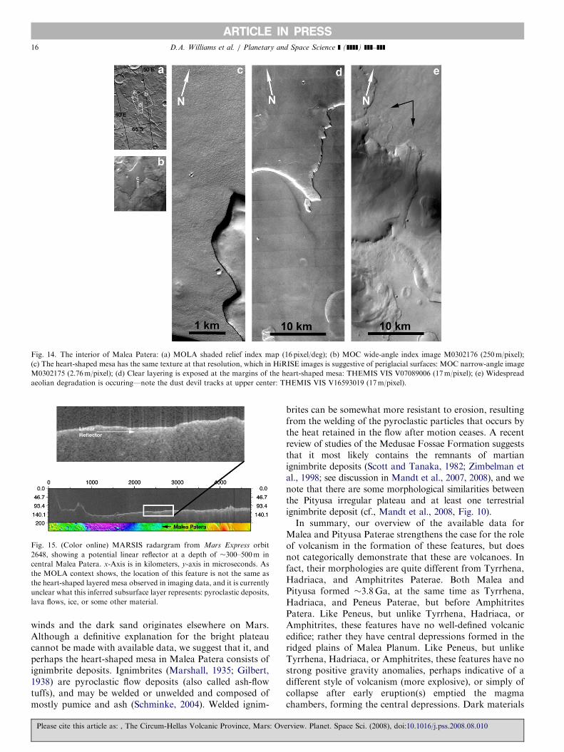
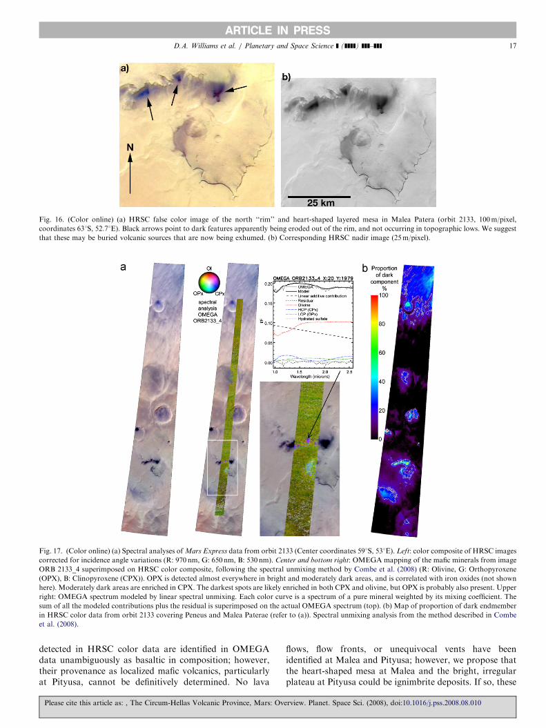
comm., 2008). The floor of Malea Patera lies at an averageof �10m in elevation, below a south and southwesttopographic high with a maximum elevation�1600–1800m. The north end of the Malea Patera flooris bordered by a �1000m topographic high, sloping up�0.31 before descending into Peneus Patera. The ‘‘rim’’ ofMalea Patera is ill-defined in MOLA and THEMIS data;wrinkle ridges in part define a possible caldera (Fig. 2b).Similar to Peneus and Amphitrites, the floor of MaleaPatera contains wrinkle ridges, pedestal craters, dark zonesin HRSC color data (Fig. 6), and an unusual heart-shapedlayered mesa �35 km wide (W–E) by �37 km long (N–S).MOC and THEMIS images (Fig. 14) show that this mesa islayered on its margin, and has an upper surface thatcontains dust devil tracks and many fine pits at the tens tohundreds of meters scale, which is expected at highersouthern latitudes (Head et al., 2003). However, Malealacks the scalloped and pitted terrain found on Peneus andAmphitrites, suggesting that Malea’s floor materials are insome way different from those in Peneus and Amphitrites.Subsurface data from several MARSIS tracks show anapparent layer under the center of Malea Patera (Fig. 15)at least 100 km long and at a depth of about 300–500m;
erview. Planet. Space Sci. (2008), doi:10.1016/j.pss.2008.08.010
ARTICLE IN PRESS
Fig. 10. (a) MOLA context for Peneus Patera (16 pixel/deg). (b) THEMIS VIS image V07551005 (17m/pixel), showing a degraded impact crater and the
stepped rim of Peneus. This topography may suggest an embedded caldera, resulting from multiple episodes of explosion and collapse.
(c) MOC-NA image E1202776 (2.9m/pixel) of the SW part of the patera’s rim showing degraded crater rim and interior, containing smaller-scale
scallops and dust devil tracks. These images clearly show that small positive relief circular structures that might appear as domes in lower-resolution data
are actually buried and exhumed impact craters. (d) THEMIS VIS image V16961008 (17m/pixel) showing irregular scalloped and pitted terrain that covers
parts of Amphitrites and Peneus Paterae. This terrain, although superficially similar to that noted near the south pole in MOC images (Malin and Edgett,
2001), is suggested to result from water ice sublimation (Lefort et al., 2005; Russell et al., 2005).
D.A. Williams et al. / Planetary and Space Science ] (]]]]) ]]]–]]] 13
however, it is currently unclear what this layer is, as itslocation is not the same as the heart-shaped layered mesa.Possibilities include lava flow, pyroclastic deposits, or ice,each of which has implications for the types of geologicactivity that occurred within Malea Patera. Because this isa relatively shallow feature and MARSIS is better atimaging deeper subsurface features (41 km: Picardi et al.,2004, 2005; Plaut et al., 2007), it may require higher spatialresolution SHARAD data to better understand this inter-face. Crater counts on the THEMIS 100m daytime-IRmosaic found a cratering model age of �3.8Ga for MaleaPatera, suggesting a very old structure.
Comparison of the HRSC nadir and color imagesyielded identification of several dark features within theinner rim of Malea Patera (Fig. 16). These appear to bepoint sources of dark material that, although beingmodified by local winds, are not accumulations intopographic lows, like many of the other dark deposits inthe CHVP. We suggest these may be point sources ofvolcanic materials, perhaps vents being exhumed. Wecompared the HRSC color data to the OMEGA data forthis orbit using several different techniques (principal
Please cite this article as: , The Circum-Hellas Volcanic Province, Mars: Ov
component analysis: Pinet et al., 2007; nonlinear spectralunmixing: Poulet et al., 2007; linear spectral unmixing:Combe et al., 2008a, b) (Fig. 17a); OMEGA dataunambigously indicate the composition of this darkmaterial is consistent with mafic volcanics, rich inclinopyroxene, orthopyroxene, and localized deposits ofolivine. Additionally, the spectroscopic information in-ferred from OMEGA data supports the idea of a basalticmaterial with close characteristics to those observed on theSyrtis Major shield (Baratoux et al., 2007a, b; Pinet et al.,2007; Poulet et al., 2007), that can be exposed or seenintermittently through the dust coverage exhibiting clearferric oxide phase characteristics typical of bright terrainsacross Mars.HRSC images are also used as 5-band multispectral data
(440 nm—blue, 530 nm—green, 650 nm—nadir, 750 nm—red, 970 nm—infrared), after calibration into radiancefactor I/F (I: observed surface radiance, F: observed solarflux or irradiance) and corrected for incidence anglevariations (division by the cosine of the incidence angle).Those spectra are mostly sensitive to two surface materials(dark mafics and bright red iron oxides) represented by two
erview. Planet. Space Sci. (2008), doi:10.1016/j.pss.2008.08.010
ARTICLE IN PRESSD.A. Williams et al. / Planetary and Space Science ] (]]]]) ]]]–]]]14
image spectral endmembers, and shade. We have foundthat we can use the spectral unmixing method of Combeet al. (2008b) on multispectral HRSC data to map theproportions of dark material (Combe and McCord, 2008)in the CHVP (Fig. 17b), to better identify the extents and
Fig. 11. Portion of THEMIS mosaic of a relatively fresh ‘‘ejecta-flow’’
crater, 5 km in diameter southwest of the Peneus Patera caldera rim. Such
crater ejecta patterns represent impacts into volatile-rich target materials
(Carr et al., 1977b; Barlow et al., 2000).
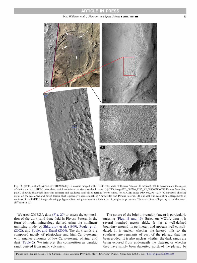
Fig. 12. (a) Part of HRSC nadir image showing a relatively young, buried and
and the unusual irregular pits a few hundred meters across within the ejecta zo
of HiRISE image PSP_004867_1220_RED, showing greater detail on the scall
temperature signature correlated with the ejecta zone of the crater.
Please cite this article as: , The Circum-Hellas Volcanic Province, Mars: Ov
locations of residual concentrations of possible volcanicmaterials (e.g., SW Malea Patera floor). In future studieswe will be able to target these locations with OMEGA datato assess if any compositional variations are present inthese dark materials (e.g., Tirsch et al., 2008).In MOLA data, Pityusa Patera occurs as an irregular
central depression surrounded by a pronounced rim on thesouth, west, and north sides (Fig. 2c), in which the centraldepression contains: (a) a southeastern rugged zone oflayered hills, (b) a northern dark sand dune field, and (c) awest-central, bright, smooth, irregular, cratered plateau.The lowest levels of the Pityusa central depression arearound 0m elevation, and the bright plateau rises to�300m. The central depression is �170 km wide (W–E) by�200 km long (N–S), and the rim is crosscut by radial tosub-parallel wrinkle ridges. The surrounding plains containmany large craters and near-concentric wrinkle ridges.Crater counts on the THEMIS 100m day-IR mosaic(Fig. 2c) give a cratering model age of �3.8Ga for thefeature, and �3.6 for the central depression (dominated bythe bright irregular plateau). Similar to Malea Patera,Pityusa lacks the scalloped and pitted terrain found onPeneus and Amphitrites, but does contain many pedestalcraters. MOC and THEMIS data reveal details about thematerials in the Pityusa central depression (Figs. 18 and19). The �100 km wide by �120 km long bright, irregularplateau is quite diverse, with a striated and heavily crateredsurface on its north side, and a heavily cratered surface thatlacks striations on the south side. The plateau has pits bothlacking and containing dark sand, in which wind streaksfrom the filled pits point to and feed the dark dune field tothe north. The hills in the southeastern part of thedepression are layered on the scale of hundreds of meters,and heavily eroded. Between the hills the surface is cut bysub-parallel sets of ridges and grooves, indicative ofextensive degradation of these layered materials.
exhumed impact crater on the northern part of Amphitrites caldera floor,
ne of the crater (HRSC image H2525_0000.nd4; 12.5m/pixel). Inset is part
oped and pitted terrain. (b) Portion of THEMIS mosaic showing the low-
erview. Planet. Space Sci. (2008), doi:10.1016/j.pss.2008.08.010
ARTICLE IN PRESS
Fig. 13. (Color online) (a) Part of THEMIS day-IR mosaic merged with HRSC color data of Peneus Patera (100m/pixel). White arrows mark the region
of dark material in HRSC color data, which contains extensive dust devil tracks. (b) CTX image P03_002296_1217_XI_58S306W of SE Peneus floor (6m/
pixel), showing scalloped inner rim (center) and scalloped and pitted terrain (lower right). (c) HiRISE image PSP_002296_1215 (50 cm/pixel) showing
detail on the scalloped and pitted terrain that is pervasive across much of Amphitrites and Peneus Paterae. (d1 and d2) Full-resolution enlargements of
sections of the HiRISE image, showing polygonal fracturing and mounds indicative of periglacial processes. There are hints of layering in the shadowed
cliff face in d2).
D.A. Williams et al. / Planetary and Space Science ] (]]]]) ]]]–]]] 15
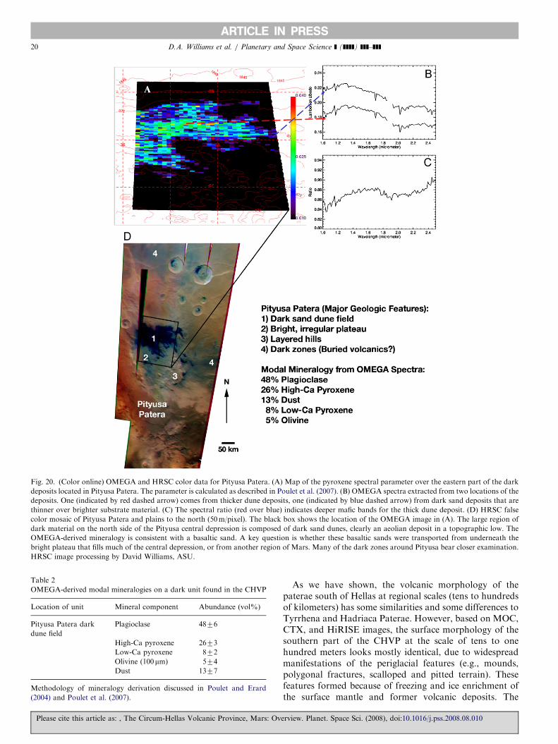
We used OMEGA data (Fig. 20) to assess the composi-tion of the dark sand dune field in Pityusa Patera, in theform of modal mineralogy derived using the nonlinearunmixing model of Shkuratov et al. (1999), Poulet et al.(2002), and Poulet and Erard (2004). The dark sands arecomposed mostly of plagioclase and high-Ca pyroxene,with smaller amounts of low-Ca pyroxene, olivine, anddust (Table 2). We interpret this composition as basalticsand, derived from mafic volcanics.
Please cite this article as: , The Circum-Hellas Volcanic Province, Mars: Ov
The nature of the bright, irregular plateau is particularlypuzzling (Figs. 18 and 19). Based on MOLA data it isseveral hundred meters thick. It has a well-definedboundary around its perimeter, and appears well-consoli-dated. It is unclear whether the layered hills to thesoutheast are remnants of part of the plateau that hasbeen eroded. It is also unclear whether the dark sands arebeing exposed from underneath the plateau, or whetherthey have simply been deposited north of the plateau by
erview. Planet. Space Sci. (2008), doi:10.1016/j.pss.2008.08.010
ARTICLE IN PRESS
Fig. 14. The interior of Malea Patera: (a) MOLA shaded relief index map (16 pixel/deg); (b) MOC wide-angle index image M0302176 (250m/pixel);
(c) The heart-shaped mesa has the same texture at that resolution, which in HiRISE images is suggestive of periglacial surfaces: MOC narrow-angle image
M0302175 (2.76m/pixel); (d) Clear layering is exposed at the margins of the heart-shaped mesa: THEMIS VIS V07089006 (17m/pixel); (e) Widespread
aeolian degradation is occuring—note the dust devil tracks at upper center: THEMIS VIS V16593019 (17m/pixel).
Fig. 15. (Color online) MARSIS radargram from Mars Express orbit
2648, showing a potential linear reflector at a depth of �300–500m in
central Malea Patera. x-Axis is in kilometers, y-axis in microseconds. As
the MOLA context shows, the location of this feature is not the same as
the heart-shaped layered mesa observed in imaging data, and it is currently
unclear what this inferred subsurface layer represents: pyroclastic deposits,
lava flows, ice, or some other material.
D.A. Williams et al. / Planetary and Space Science ] (]]]]) ]]]–]]]16
winds and the dark sand originates elsewhere on Mars.Although a definitive explanation for the bright plateaucannot be made with available data, we suggest that it, andperhaps the heart-shaped mesa in Malea Patera consists ofignimbrite deposits. Ignimbrites (Marshall, 1935; Gilbert,1938) are pyroclastic flow deposits (also called ash-flowtuffs), and may be welded or unwelded and composed ofmostly pumice and ash (Schminke, 2004). Welded ignim-
Please cite this article as: , The Circum-Hellas Volcanic Province, Mars: Ov
brites can be somewhat more resistant to erosion, resultingfrom the welding of the pyroclastic particles that occurs bythe heat retained in the flow after motion ceases. A recentreview of studies of the Medusae Fossae Formation suggeststhat it most likely contains the remnants of martianignimbrite deposits (Scott and Tanaka, 1982; Zimbelman etal., 1998; see discussion in Mandt et al., 2007, 2008), and wenote that there are some morphological similarities betweenthe Pityusa irregular plateau and at least one terrestrialignimbrite deposit (cf., Mandt et al., 2008, Fig. 10).In summary, our overview of the available data for
Malea and Pityusa Paterae strengthens the case for the roleof volcanism in the formation of these features, but doesnot categorically demonstrate that these are volcanoes. Infact, their morphologies are quite different from Tyrrhena,Hadriaca, and Amphitrites Paterae. Both Malea andPityusa formed �3.8Ga, at the same time as Tyrrhena,Hadriaca, and Peneus Paterae, but before AmphitritesPatera. Like Peneus, but unlike Tyrrhena, Hadriaca, orAmphitrites, these features have no well-defined volcanicedifice; rather they have central depressions formed in theridged plains of Malea Planum. Like Peneus, but unlikeTyrrhena, Hadriaca, or Amphitrites, these features have nostrong positive gravity anomalies, perhaps indicative of adifferent style of volcanism (more explosive), or simply ofcollapse after early eruption(s) emptied the magmachambers, forming the central depressions. Dark materials
erview. Planet. Space Sci. (2008), doi:10.1016/j.pss.2008.08.010
ARTICLE IN PRESS
Fig. 16. (Color online) (a) HRSC false color image of the north ‘‘rim’’ and heart-shaped layered mesa in Malea Patera (orbit 2133, 100m/pixel,
coordinates 631S, 52.71E). Black arrows point to dark features apparently being eroded out of the rim, and not occurring in topographic lows. We suggest
that these may be buried volcanic sources that are now being exhumed. (b) Corresponding HRSC nadir image (25m/pixel).
Fig. 17. (Color online) (a) Spectral analyses of Mars Express data from orbit 2133 (Center coordinates 591S, 531E). Left: color composite of HRSC images
corrected for incidence angle variations (R: 970 nm, G: 650 nm, B: 530 nm). Center and bottom right: OMEGA mapping of the mafic minerals from image
ORB 2133_4 superimposed on HRSC color composite, following the spectral unmixing method by Combe et al. (2008) (R: Olivine, G: Orthopyroxene
(OPX), B: Clinopyroxene (CPX)). OPX is detected almost everywhere in bright and moderately dark areas, and is correlated with iron oxides (not shown
here). Moderately dark areas are enriched in CPX. The darkest spots are likely enriched in both CPX and olivine, but OPX is probably also present. Upper
right: OMEGA spectrum modeled by linear spectral unmixing. Each color curve is a spectrum of a pure mineral weighted by its mixing coefficient. The
sum of all the modeled contributions plus the residual is superimposed on the actual OMEGA spectrum (top). (b) Map of proportion of dark endmember
in HRSC color data from orbit 2133 covering Peneus and Malea Paterae (refer to (a)). Spectral unmixing analysis from the method described in Combe
et al. (2008).
D.A. Williams et al. / Planetary and Space Science ] (]]]]) ]]]–]]] 17
detected in HRSC color data are identified in OMEGAdata unambiguously as basaltic in composition; however,their provenance as localized mafic volcanics, particularlyat Pityusa, cannot be definitively determined. No lava
Please cite this article as: , The Circum-Hellas Volcanic Province, Mars: Ov
flows, flow fronts, or unequivocal vents have beenidentified at Malea and Pityusa; however, we propose thatthe heart-shaped mesa at Malea and the bright, irregularplateau at Pityusa could be ignimbrite deposits. If so, these
erview. Planet. Space Sci. (2008), doi:10.1016/j.pss.2008.08.010

ARTICLE IN PRESS
Fig. 18. Features in the interior of the Pityusa Patera central depression: (a) MOLA shaded relief index map (16 pixel/deg); (b) portion of the THEMIS
VIS image V16993020 (17m/pixel), showing a striated upper surface to the large, bright, irregular, plateau. Holes in the plateau are filled with dark sand,
and wind streaks mark a generally northly wind direction, in which dark sands are deposits forming a dune field; (c) portion of the THEMIS VIS image
V18172008 (17m/pixel); (d) THEMIS VIS image V06303008 (17m/pixel), showing eroded, layered hills; (e and f) fragments of the THEMIS VIS image
V06303008.
D.A. Williams et al. / Planetary and Space Science ] (]]]]) ]]]–]]]18
would indicate a different style of volcanism at Malea andPityusa compared to the other volcanoes in the Province.
5. Discussion
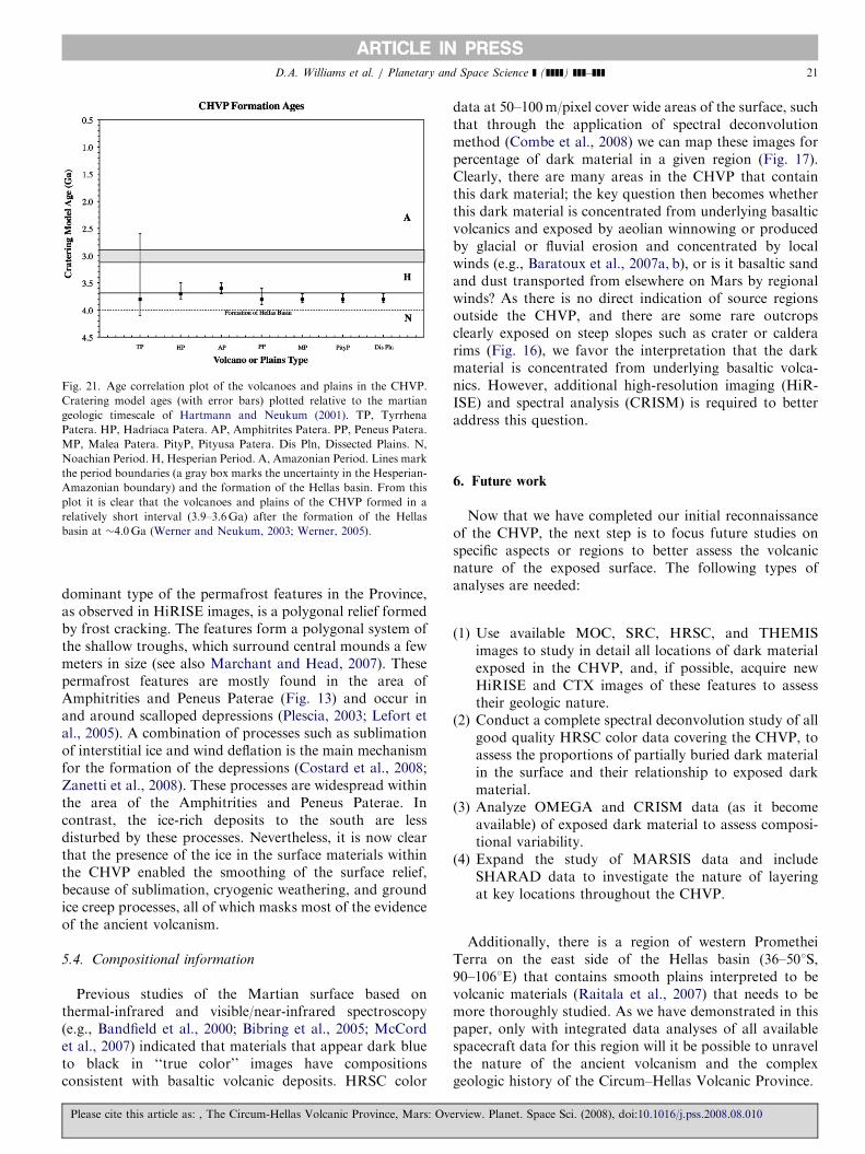
5.1. Ages
Crater size–frequency distribution (CFD) results(Table 1, Fig. 21) show that the six highland paterae arein the same age-range, but that Tyrrhena, Peneus, Malea,and Pityusa are slightly older at 3.8Ga, while Hadriaca andAmphitrites are younger at 3.7 and 3.6Ga, respectively.These differences may not be that significant, consideringthe 100Ma error bar on the Hartmann and Neukum
technique. However, the caldera ages all range from 3.8to 3.2Ga, and are substantially older than those observedon the floors of the Tharsis volcanoes, most of which areyounger than 0.5Ga (Neukum et al., 2004b). Based on theobservations from the new data presented here and fromprevious studies, we suggest that the main constructs of thehighland patera around the Hellas basin formed over theperiod of 4–3.6Ga, making them the oldest preservedvolcanoes on Mars and (in agreement with previousstudies) reflecting a change in eruptive style from theputative earlier fissure-fed flood eruptions to local edifice-building eruptions. The ages of Peneus, Malea, and PityusaPaterae are also consistent with the ages of valley networks(�3.7–3.5Ga: Fassett and Head, 2008) and the time whenextensive amounts of water existed (at least temporarily) onthe surface (e.g., Carr, 1996). If Malea and Pityusa Pateraeare the Martian equivalent of ancient giant calderas or
Please cite this article as: , The Circum-Hellas Volcanic Province, Mars: Ov
‘‘supervolcanoes’’ (e.g., Self, 2006) that produced ignim-brite deposits, then these eruptions likely involved sub-stantial amounts of volatiles (such as water) in the magma.If early Mars was characterized by generally wetterconditions (i.e., abundant groundwater in the shallowcrust), then these conditions might have enabled thesetypes of large explosive eruptions.
5.2. Structure and topography
MOLA profiles and the MGS (Lemoine et al., 2001) andMRO gravity data show dissimilarities among the sixvolcanoes of the CHVP. The three volcanoes with positive-relief edifices in MOLA data (Tyrrhena, Hadriaca, andAmphtrites) also have strong positive gravity anomalies,perhaps indicative of dense magma bodies below thesurface. The other three volcanoes (Peneus, Malea, andPityusa) have central depressions within the surroundingplains, and lack both the shield-like edifices and the strongpositive gravity anomalies observed at the other threevolcanoes. If these paterae are the remnants of giantMartian calderas that produced explosive eruptions andthat, in the case of Malea and Pityusa Paterae, producedignimbrite deposits, then there was a larger diversity ofvolcanic eruption styles in the CHVP than has previouslybeen considered.
5.3. Morphology and surface degradation
If this is a volcanic province, then where are all thevolcanic vents and lava flow boundaries? The detailed
erview. Planet. Space Sci. (2008), doi:10.1016/j.pss.2008.08.010
ARTICLE IN PRESS
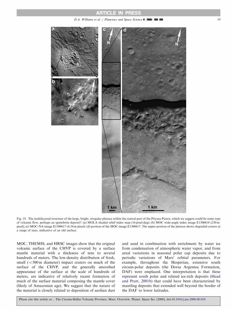
Fig. 19. The multilayered structure of the large, bright, irregular plateau within the central part of the Pityusa Patera, which we suggest could be some type
of volcanic flow, perhaps an ignimbrite deposit?: (a) MOLA shaded relief index map (16 pixel/deg); (b) MOC wide-angle index image E1300618 (250m/
pixel); (c) MOC-NA image E1300617 (4.34m/pixel); (d) portion of the MOC image E1300617. The upper portion of the plateau shows degraded craters at
a range of sizes, indicative of an old surface.
D.A. Williams et al. / Planetary and Space Science ] (]]]]) ]]]–]]] 19
MOC, THEMIS, and HRSC images show that the originalvolcanic surface of the CHVP is covered by a surfacemantle material with a thickness of tens to severalhundreds of meters. The low-density distribution of fresh,small (o500m diameter) impact craters on much of thesurface of the CHVP, and the generally smoothedappearance of the surface at the scale of hundreds ofmeters, are indicative of relatively recent formation ofmuch of the surface material composing the mantle cover(likely of Amazonian age). We suggest that the nature ofthe material is closely related to deposition of aeolian dust
Please cite this article as: , The Circum-Hellas Volcanic Province, Mars: Ov
and sand in combination with enrichment by water icefrom condensation of atmospheric water vapor, and fromareal variations in seasonal polar cap deposits due toperiodic variations of Mars’ orbital parameters. Forexample, throughout the Hesperian, extensive southcircum-polar deposits (the Dorsa Argentea Formation,DAF) were emplaced. One interpretation is that theserepresent south polar and related ice-rich deposits (Headand Pratt, 2001b) that could have been characterized bymantling deposits that extended well beyond the border ofthe DAF to lower latitudes.
erview. Planet. Space Sci. (2008), doi:10.1016/j.pss.2008.08.010
ARTICLE IN PRESS
Fig. 20. (Color online) OMEGA and HRSC color data for Pityusa Patera. (A) Map of the pyroxene spectral parameter over the eastern part of the dark
deposits located in Pityusa Patera. The parameter is calculated as described in Poulet et al. (2007). (B) OMEGA spectra extracted from two locations of the
deposits. One (indicated by red dashed arrow) comes from thicker dune deposits, one (indicated by blue dashed arrow) from dark sand deposits that are
thinner over brighter substrate material. (C) The spectral ratio (red over blue) indicates deeper mafic bands for the thick dune deposit. (D) HRSC false
color mosaic of Pityusa Patera and plains to the north (50m/pixel). The black box shows the location of the OMEGA image in (A). The large region of
dark material on the north side of the Pityusa central depression is composed of dark sand dunes, clearly an aeolian deposit in a topographic low. The
OMEGA-derived mineralogy is consistent with a basaltic sand. A key question is whether these basaltic sands were transported from underneath the
bright plateau that fills much of the central depression, or from another region of Mars. Many of the dark zones around Pityusa bear closer examination.
HRSC image processing by David Williams, ASU.
Table 2
OMEGA-derived modal mineralogies on a dark unit found in the CHVP
Location of unit Mineral component Abundance (vol%)
Pityusa Patera dark
dune field
Plagioclase 4876
High-Ca pyroxene 2673
Low-Ca pyroxene 872
Olivine (100mm) 574
Dust 1377
Methodology of mineralogy derivation discussed in Poulet and Erard
(2004) and Poulet et al. (2007).
D.A. Williams et al. / Planetary and Space Science ] (]]]]) ]]]–]]]20
Please cite this article as: , The Circum-Hellas Volcanic Province, Mars: Ov
As we have shown, the volcanic morphology of thepaterae south of Hellas at regional scales (tens to hundredsof kilometers) has some similarities and some differences toTyrrhena and Hadriaca Paterae. However, based on MOC,CTX, and HiRISE images, the surface morphology of thesouthern part of the CHVP at the scale of tens to onehundred meters looks mostly identical, due to widespreadmanifestations of the periglacial features (e.g., mounds,polygonal fractures, scalloped and pitted terrain). Thesefeatures formed because of freezing and ice enrichment ofthe surface mantle and former volcanic deposits. The
erview. Planet. Space Sci. (2008), doi:10.1016/j.pss.2008.08.010
ARTICLE IN PRESS
Fig. 21. Age correlation plot of the volcanoes and plains in the CHVP.
Cratering model ages (with error bars) plotted relative to the martian
geologic timescale of Hartmann and Neukum (2001). TP, Tyrrhena
Patera. HP, Hadriaca Patera. AP, Amphitrites Patera. PP, Peneus Patera.
MP, Malea Patera. PityP, Pityusa Patera. Dis Pln, Dissected Plains. N,
Noachian Period. H, Hesperian Period. A, Amazonian Period. Lines mark
the period boundaries (a gray box marks the uncertainty in the Hesperian-
Amazonian boundary) and the formation of the Hellas basin. From this
plot it is clear that the volcanoes and plains of the CHVP formed in a
relatively short interval (3.9–3.6Ga) after the formation of the Hellas
basin at �4.0Ga (Werner and Neukum, 2003; Werner, 2005).
D.A. Williams et al. / Planetary and Space Science ] (]]]]) ]]]–]]] 21
dominant type of the permafrost features in the Province,as observed in HiRISE images, is a polygonal relief formedby frost cracking. The features form a polygonal system ofthe shallow troughs, which surround central mounds a fewmeters in size (see also Marchant and Head, 2007). Thesepermafrost features are mostly found in the area ofAmphitrities and Peneus Paterae (Fig. 13) and occur inand around scalloped depressions (Plescia, 2003; Lefort etal., 2005). A combination of processes such as sublimationof interstitial ice and wind deflation is the main mechanismfor the formation of the depressions (Costard et al., 2008;Zanetti et al., 2008). These processes are widespread withinthe area of the Amphitrities and Peneus Paterae. Incontrast, the ice-rich deposits to the south are lessdisturbed by these processes. Nevertheless, it is now clearthat the presence of the ice in the surface materials withinthe CHVP enabled the smoothing of the surface relief,because of sublimation, cryogenic weathering, and groundice creep processes, all of which masks most of the evidenceof the ancient volcanism.
5.4. Compositional information
Previous studies of the Martian surface based onthermal-infrared and visible/near-infrared spectroscopy(e.g., Bandfield et al., 2000; Bibring et al., 2005; McCordet al., 2007) indicated that materials that appear dark blueto black in ‘‘true color’’ images have compositionsconsistent with basaltic volcanic deposits. HRSC color
Please cite this article as: , The Circum-Hellas Volcanic Province, Mars: Ov
data at 50–100m/pixel cover wide areas of the surface, suchthat through the application of spectral deconvolutionmethod (Combe et al., 2008) we can map these images forpercentage of dark material in a given region (Fig. 17).Clearly, there are many areas in the CHVP that containthis dark material; the key question then becomes whetherthis dark material is concentrated from underlying basalticvolcanics and exposed by aeolian winnowing or producedby glacial or fluvial erosion and concentrated by localwinds (e.g., Baratoux et al., 2007a, b), or is it basaltic sandand dust transported from elsewhere on Mars by regionalwinds? As there is no direct indication of source regionsoutside the CHVP, and there are some rare outcropsclearly exposed on steep slopes such as crater or calderarims (Fig. 16), we favor the interpretation that the darkmaterial is concentrated from underlying basaltic volca-nics. However, additional high-resolution imaging (HiR-ISE) and spectral analysis (CRISM) is required to betteraddress this question.
6. Future work
Now that we have completed our initial reconnaissanceof the CHVP, the next step is to focus future studies onspecific aspects or regions to better assess the volcanicnature of the exposed surface. The following types ofanalyses are needed:
(1)
ervie
Use available MOC, SRC, HRSC, and THEMISimages to study in detail all locations of dark materialexposed in the CHVP, and, if possible, acquire newHiRISE and CTX images of these features to assesstheir geologic nature.
(2)
Conduct a complete spectral deconvolution study of allgood quality HRSC color data covering the CHVP, toassess the proportions of partially buried dark materialin the surface and their relationship to exposed darkmaterial.(3)
Analyze OMEGA and CRISM data (as it becomeavailable) of exposed dark material to assess composi-tional variability.(4)
Expand the study of MARSIS data and includeSHARAD data to investigate the nature of layeringat key locations throughout the CHVP.Additionally, there is a region of western PrometheiTerra on the east side of the Hellas basin (36–501S,90–1061E) that contains smooth plains interpreted to bevolcanic materials (Raitala et al., 2007) that needs to bemore thoroughly studied. As we have demonstrated in thispaper, only with integrated data analyses of all availablespacecraft data for this region will it be possible to unravelthe nature of the ancient volcanism and the complexgeologic history of the Circum–Hellas Volcanic Province.
w. Planet. Space Sci. (2008), doi:10.1016/j.pss.2008.08.010
ARTICLE IN PRESSD.A. Williams et al. / Planetary and Space Science ] (]]]]) ]]]–]]]22
Acknowledgments
We thank Laszlo Keszthelyi and Renee Weber of the USG.S., and two anonymous reviewers, for offering helpfulcomments and suggestions. We were gratified when onereviewer commented, ‘‘this is one of the best HRSC papersI’ve ever seen!’’. We thank Chris Edwards and theTHEMIS team for producing several of the THEMISmosaics and for useful discussions on interpreting THE-MIS data. The authors acknowledge the use of MarsOrbiter Camera images processed by Malin Space ScienceSystems that are available at http://www.msss.com/moc_gallery/. We thank the members of the following instru-ment teams for acquiring new data that are changing ourunderstanding of Mars: MOLA, TES, GRS, HiRISE,CTX, and MARSIS. We particularly thank Devin Wallerfor assistance in interpreting the MARSIS data. We thankthe HRSC Experiment Teams at DLR Berlin and the FreieUniversitat Berlin as well as the Mars Express ProjectTeams at ESTEC and ESOC for their successful planningand acquisition of data, as well as for making the processeddata available to the HRSC Team. We acknowledge theeffort of the HRSC Co-Investigator Team members andtheir associates who have contributed to this investigationin the preparatory phase and in scientific discussions withinthe Team. This research was supported by NASA throughthe Jet Propulsion Laboratory for US participation in theESA Mars Express mission, and through the NASAPlanetary Geology and Geophysics Program.
Appendix A
A.1. Crater count methods
Crater size–frequency distributions (CFDs) for the sixvolcanoes of the CHVP were obtained to derive a generalsequence of events and their relation to general Martianhistory. We produced mosaics covering Tyrrhena, Hadria-ca, Amphitrites, Peneus, Malea, and Pityusa Paterae usingthe THEMIS daytime-IR data at 100m/pixel as astandardized base. Because there is controversy regardingCFDs for dating surfaces on Mars especially with regard toestimating ‘‘absolute’’ dates and the use of statistics basedon small craters (McEwen et al., 2005), our approach inthis study was to: (1) use craters 4800m diameter to avoidthe addition of secondary craters which would yielderroneously old ages, and (2) use the results primarily forage comparisons within individual volcanoes, and forcomparisons among the patera and other volcanoes onMars (i.e., even though the ‘‘absolute’’ dates might not beaccurate, the relative ages can be used for such compar-isons). Recent work based on impact craters discovered inMOC data to have formed over the last 7 years on Mars(Malin et al., 2006) suggests that the cratering rate forMars extrapolated from the Moon is essentially correct(Hartmann, 2005). Nevertheless, restricting our CFDs to
Please cite this article as: , The Circum-Hellas Volcanic Province, Mars: Ov
large craters and using ages for relative comparisonsshould produce more conservative results.Crater measurements were tabulated, partitioned into
bins of increasing crater diameter based on standardpractices, and these binned data were used to producecumulative CFD plots with corresponding statistical errors(see e.g., Hartmann, 1966; Neukum and Wise, 1976; CraterAnalysis Techniques Working Group, 1979; Neukum andHiller, 1981; Neukum, 1983) using the CRATERSTATSpackage developed by the Free University, Berlin (Michaeland Neukum, 2008: http://hrscview.fu-berlin.de/craterstats.html). In this technique, the cumulative CFDs wereanalyzed to determine crater densities at specific referencediameters, and cratering model ages following Hartmannand Neukum (2001). Cumulative crater densities for 1-, 2-,5-, 10- and 16-km diameter craters were used by Hartmannand Neukum (2001) to assess relative ages for martiangeologic units and to place units into the martianchronologic system using key units as referents (e.g.,Tanaka et al., 1992). In general, the lower the craterdensity (the fewer the craters that formed or have beenretained (preserved) on the surface), the younger the age. Acratering model age (in Ga) is calculated from thecumulative crater density at a reference crater diameter of1 km using an established cratering chronology model forMars (Neukum, 1983; Hartmann and Neukum, 2001;Ivanov, 2001), which is typically extrapolated from thelunar model (in which crater frequencies are correlatedwith radiometric ages from Apollo samples) that has beenadjusted for the different orbital mechanics, crater scaling,and impact flux for Mars relative to the Moon. Thetransfer of the lunar cratering chronology model to Marsmay introduce a systematic error of up to a factor of 2.This means that the typical uncertainty in cratering modelages could vary by a factor of 2 for ages o3.5Ga (in theconstant flux range), whereas the uncertainty is about7100Ma for ages 43.5Ga (Hartmann and Neukum,2001). Extensive testing and application of these techni-ques, however, have shown that the applied martiancratering chronology model results in ages for basinformation and volcanic surfaces that are in good agreementwith Martian meteorite crystallization ages with respect to‘‘peak’’ activity periods (Neukum et al., 2007), whichsuggests that the chronology model is correct within anuncertainty of less than 20% (Werner, 2005). Specific errorbars for each cratering model age are included in Table 1.The results obtained for Hadriaca Patera and TyrrhenaPatera were compared with previous CFDs made fromcounts on higher-resolution HRSC images (Williams et al.2007, 2008). Ages for the ‘‘Edifice’’ were obtained fromhomogeneous surfaces that are considered to represent themain structure of the volcano. ‘‘Caldera’’ ages wereobtained for the smoothest surfaces that are consideredto represent eruptions of flood lavas or ash, or deposits ofnon-volcanic origin. All of these surfaces have been highlymodified by degradational processes. In most cases, CFDsshow ‘‘kinks’’ in the cumulative distributions that are
erview. Planet. Space Sci. (2008), doi:10.1016/j.pss.2008.08.010

ARTICLE IN PRESSD.A. Williams et al. / Planetary and Space Science ] (]]]]) ]]]–]]] 23
considered to represent resurfacing events, in which thesmaller craters are obliterated, while the larger craters arestill visible and can be counted. Resurfacing events caninclude mantling by windblown, volcanic, or otherdeposits, or surface degradation processes, such as masswasting or periglacial activity, that might differentiallyremove smaller craters. Because of the uncertainty in theprocess(es) leading to these ‘‘kinks,’’ and the focus of thisstudy on the major volcanic events, this aspect of the CFDsis not considered.
A.2. Spectroscopy methods: Fig. 17
OMEGA spectra are calibrated into radiance factor (I/F)and corrected for atmospheric absorptions using anempirical method, which consists of using a syntheticatmospheric transmittance corresponding to the ratio oftwo spectra acquired at the top and bottom of OlympusMons and scaling it to the depth of the 2 mm CO2 band. Werestricted the analysis to the OMEGA Short WavelengthInfrared (SWIR) detector (0.96–2.57 mm) to eliminate inter-detector calibration and registration discrepancies.Furthermore, the SWIR detector covers a wavelengthrange that contains the most diagnostic bands.
The method of spectral unmixing applied here (Combeet al., 2008) is a pixel-by-pixel spectral linear deconvolutionthat relies on a reference spectral library of 20 pureminerals. Minerals represented include mafics, iron oxides,sulfates, clays, carbonates, and water ice. Two modeledspectra account for atmosphere and surface photometriceffects. Each OMEGA spectrum is modeled by a maximumof four mineral components. This limitation preventsinsignificant endmembers from being included in themodel. The maps of the minerals vary with abundances,but they are not proportions, since mixing coefficients arealso sensitive to grain size variations.
A.3. Spectroscopy methods: Fig. 18 and Table 2
Modal mineralogy is derived using the nonlinearunmixing modeling based on the Shkuratov radiativetransfer model (Shkuratov et al., 1999; Poulet et al.,2002; Poulet and Erard, 2004). Poulet et al. (2002) showedthe degree of realism and efficiency of this model relative toother scattering models, and in particular to the Hapkemodel and its derivatives. This model has also been testedto determine the type of mixture (sand, areal, or bedrock),the relative proportions, and the grain sizes of componentsof laboratory mineral samples (Poulet and Erard, 2004), aswell as applied to spectra of several planetary surfaces. Foreach spectrum the model had to satisfy two majorconstraints: the depth and the shape of the absorption(s)band(s) and the average value of the reflectance. Oneadditional free parameter was used to modestly adjust thecontinuum spectral slope resulting from aerosols and/orphotometric effects. The data were fit using a simplexminimization algorithm.
Please cite this article as: , The Circum-Hellas Volcanic Province, Mars: Ov
Although nonlinear mixing of reflectance spectra is apowerful way to explore data sets, the method haslimitations. First, the set of optical constants used asendmembers must be representative of materials that areunder study. Because we apply the nonlinear unmixingmethod to low albedo regions that are dominated bybasaltic materials, the minerals used in this paper arepyroxene (both low- and high-calcium), olivine (both Fe-and Mg-rich), feldspar (labradorite) and a dark oxide(magnetite). The optical constants were derived using thescheme described in Poulet and Erard (2004) fromreflectance spectra.
References
Bandfield, J.L., Hamilton, V.E., Christensen, P.R., 2000. A global view of
Martian surface compositions from MGS-TES. Science 287,
1626–1630.
Baratoux, D., Pinet, P.C., Gendrin, A., Kanner, L., Mustard, J., Daydou,
Y., Vaucher, J., Bibring, J.P., the OMEGA Science Team, 2007a. The
mineralogical structure of the subsurface of Syrtis Major from
OMEGA observations of lobate ejecta blankets. J. Geophys. Res.
112, E08S05.
Baratoux, D., Mangold, N., Arnalds, O., Gregoire, M., Plavoet, B.,
Bardinzeff, J.-M., Pinet, P., 2007b. Formation, transport and
mineralogical evolution of basaltic sands on Earth and Mars. In:
Seventh International Conference on Mars, Abstract #3048. Lunar
and Planetary Institute, Houston (CD-ROM).
Barlow, N.G., Boyce, J.M., Costard, F.M., Craddock, R.A., Garvin, J.B.,
Sakimoto, S.E.H., Kuzmin, R.O., Roddy, D.J., Soderblom, L.A.,
2000. Standardizing the nomenclature of Martian impact crater ejecta
morphologies. J. Geophys. Res. 105 (E11), 26,733–26,738.
Barsukov, V.L., et al., 1986. The geology and geomorphology of the
Venus surface as revealed by radar images obtained by Veneras 15 and
16. J. Geophys. Res. 91, 378–398.
Bibring, J.-P., Soufflot, A., Berthe, M., Langevin, Y., Gondet, B.,
Drossart, P., Bouye, M., Combes, M., Puget, P., Semery, A., Bellucci,
G., Formisano, V., Moroz, V., Kottsov, V., the OMEGA Co-
Investigator Team, 2004. OMEGA: Observatoire pour la Mineralogie,
l’Eau, les Glaces et l’Activite. ESA Special Publication, vol. 1240,
pp. 37–50.
Bibring, J.-P., Langevin, Y., Gendrin, A., Gondet, B., Poulet, F., Berthe,
M., Soufflot, A., Arvidson, R., Mangold, N., Mustard, J., Drossart,
P., the OMEGA Team, 2005. Mars surface diversity as revealed by the
OMEGA/Mars Express observations. Science 307, 1576–1581.
Carr, M.H., 1973. Volcanism on Mars. J. Geophys. Res. 78, 4049–4062.
Carr, M.H., 1976. The volcanoes of Mars. Sci. Am. 234, 33–43.
Carr, M.H., 1981. The Surface of Mars. Yale University Press, New
Haven, CT, 232pp.
Carr, M.H., 1996. Water on Mars. Oxford University Press, New York,
NY, 248pp.
Carr, M.H., Masursky, H., Saunders, R.S., 1973. Generalized geologic
map of Mars. J. Geophys. Res. 78, 4031–4036.
Carr, M.H., Blasius, K.R., Greeley, R., Guest, J.E., Murray, J.E., 1977a.
Observations on some Martian volcanic features as viewed from the
Viking orbiters. J. Geophys. Res. 82, 3985–4015.
Carr, M.H., Crumpler, L.S., Cutts, J.A., Greeley, R., Guest, J.E.,
Masursky, H., 1977b. Martian impact craters and emplacement of
ejecta by surface flow. J. Geophys. Res. 82, 4055–4065.
Christensen, P.R., et al., 2001. Mars Global Surveyor Thermal Emission
Spectrometer experiment: investigation description and surface science
results. J. Geophys. Res. 106, 23,823–23,871.
Christensen, P.R., et al., 2004. The Thermal Emission Imaging System
(THEMIS) for the Mars 2001 Odyssey mission. Space Sci. Rev. 110,
85–130.
erview. Planet. Space Sci. (2008), doi:10.1016/j.pss.2008.08.010
ARTICLE IN PRESSD.A. Williams et al. / Planetary and Space Science ] (]]]]) ]]]–]]]24
Combe, J.-Ph., McCord, T.B., 2008. Mars Express/HRSC spectral data of
MER landing sites analyzed by a Multiple-Endmember Linear
Spectral Linear Unmixing Model (MELSUM). In: Lunar and
Planetary Science XXXIX, Abstract #2381. Lunar and Planetary
Institute, Houston (CD-ROM).
Combe, J.-Ph., Le Mouelic, S., Sotin, C., Gendrin, A., Mustard, J.F., Le
Deit, L., Launeau, P., Bibring, J.-P., Gondet, B., Langevin, Y., Pinet,
P., the OMEGA Science Team, 2008. Analysis of OMEGA/Mars
Express data hyperspectral data using a Multiple-Endmember Linear
Spectral Unmixing Model (MELSUM): Methodology and first results,
Planet. Space Sci. 56, 951–975.
Costard, F., Forget, F., Madeleine, J.B., Soare, R.J., Kargel, J.S., 2008.
The origin and formation of scalloped terrain in Utopia Planitia:
insight from a General Circulation Model. In: Lunar and Planetary
Science XXXIX, Abstract #1274. Lunar and Planetary Institute,
Houston (CD-ROM).
Crater Analysis Techniques Working Group, 1979. Standard techniques
for presentation and analysis of crater size–frequency data. Icarus 37,
467–474.
Crown, D.A., Greeley, R., 1993. Volcanic geology of Hadriaca Patera and
the eastern Hellas region of Mars. J. Geophys. Res. 98, 3431–3451.
Crown, D.A., Greeley, R., 2007. Geologic map of MTM quadrangles
�30262 and �30267, Hadriaca Patera region of Mars. US Geol. Surv.
Sci. Invest. Ser. Map 2936.
Crown, D.A., Price, K.H., Greeley, R., 1992. Geologic evolution of the
east rim of the Hellas basin, Mars. Icarus 100, 1–25.
Crumpler, L.S., Head, J.W., Aubele, J.C., 1996. Calderas on Mars:
characteristics, structure, and associated flank deformation. In:
McGuire, W.J., Jones, A.P., Neuberg, J. (Eds.), Volcano Instability
on the Earth and Other Planets. Geological Society Special Publica-
tion, vol. 110, pp. 307–348.
Fassett, C.I., Head, J.W., 2008. The timing of martian valley network
activity: Constraints from buffered crater counting. Icarus 195, 61–89.
Frey, H., Schultz, R.A., Reidy, A.-M., Wolfe, H., 1991. A large pre-Hellas
impact basin in the southern hemisphere of Mars (abstract). Lunar
Planet. Sci. Conf. XXII, 421–422.
Gilbert, C.M., 1938. Welded tuff in eastern California. Geol. Soc. Am.
Bull. 49, 1829–1862.
Greeley, R., Crown, D.A., 1990. Volcanic geology of Tyrrhena Patera,
Mars. J. Geophys. Res. 95, 7133–7149.
Greeley, R., Guest, J.E., 1987. Geologic map of the eastern equatorial
region of Mars. US Geological Survey Miscellaneous Investigations
Series Map I-1802B, scale 1:15,000,000.
Greeley, R., Spudis, P.D., 1981. Volcanism on Mars. Rev. Geophys. Space
Phys. 19, 13–41.
Gregg, T.K.P., Farley, M.A., 2006. Mafic pyroclastic flows at Tyrrhena
Patera, Mars: constraints from observations and models. J. Volcan.
Geotherm. Res. 155, 81–89.
Gregg, T.K.P., Crown, D.A., Greeley, R., 1998. Geologic map of part of
Tyrrhena Patera region of Mars (MTM Quadrangle �20252). US
Geol. Surv. Map I-2556.
Hartmann, W.K., 1966. Martian cratering. Icarus 5, 565–576.
Hartmann, W.K., 2005. Martian cratering 8: isochron refinement and the
chronology of Mars. Icarus 174, 294–320.
Hartmann, W.K., Neukum, G., 2001. Cratering chronology and the
evolution of Mars. Space Sci. Rev. 96, 165–194.
Head, J.W., Pratt, S., 2001a. Malea Planum Hesperian volcanic province:
characterization using MOLA data. In: Lunar and Planetary Science
XXXII, Abstract #1627. Lunar and Planetary Institute, Houston (CD-
ROM).
Head, J.W., Pratt, S.F., 2001b. Extensive Hesperian-aged south polar ice
sheet on Mars; Evidence for massive melting and retreat, and lateral
flow and ponding of meltwater. J. Geophys. Res. 106 (E6),
12,275–12,299.
Head, J.W., Crumpler, L.S., Aubele, J.C., Guest, J.E., Saunders, R.S.,
1992. Venus volcanism: classification of volcanic features and
structures, associations, and global distribution from Magellan data.
J. Geophys. Res. 97 (E8), 13,153–13,197.
Please cite this article as: , The Circum-Hellas Volcanic Province, Mars: Ov
Head, J.W., Mustard, J.F., Kreslavsky, M.A., Milliken, R.E., Marchant,
D.R., 2003. Recent ice ages on Mars. Nature 426, 797–802.
Head, J.W., Wilson, L., Dickson, J.L., Neukum, G., the HRSC Co-
Investigator Team, 2006. The Huygens-Hellas giant dike system on
Mars: implications for Late Noachian–Early Hesperian volcanic
resurfacing and climatic evolution. Geology 34, 285–288.
Ivanov, B., 2001. Mars/Moon cratering rate ratio estimates. Space Sci.
Rev. 96, 87–104.
Kadish, S.J., Head, J.W., Barlow, N.G., 2008a. Pedestal craters on Mars:
distribution, characteristics, and implications for Amazonian climate
change. In: Lunar and Planetary Science XXXIX, Abstract #1766.
Lunar and Planetary Institute, Houston (CD-ROM).
Kadish, S.J., Head, J.W., Barlow, N.G., Marchant, D.R., 2008b. Martian
pedestal craters: marginal sublimation pits implicate a climate-related
forcing mechanism. Geophys. Res. Lett. 35, L16104, doi:10.1029/
2008GL034990.
Kolb, E.J., Tanaka, K.L., 2008. Geologic map of the Planum Australe
region of Mars. US Geological Survey Miscellaneous Investigations
Series, in review.
Larson, S.K., 2007. The origins of four paterae of Malea Planum, Mars.
Unpublished M.S. Thesis, Brigham Young University, Provo, UT, 120pp.
Lefort, A., Russell, P., Thomas, N., 2005. Ice sublimation landforms in
Peneus and Amphitrites Patera. In: Lunar and Planetary Science
XXXVI, Abstract #1626. Lunar and Planetary Institute, Houston
(CD-ROM).
Lemoine, F.G., Smith, D.E., Rowlands, D.D., Zuber, M.T., Neumann,
G.A., Chinn, D.S., Pavlis, D.E., 2001. An improved solution of the
gravity field of Mars (GMM-2B) from Mars Global Surveyor.
J. Geophys. Res. 106 (#E10), 23,359–23,376.
Leonard, G.J., Tanaka, K.L., 2001. Geologic map of the Hellas region of
Mars. US Geol. Surv. Misc. Invest. Ser. Map I-2694.
Levy, J.S., Head, J.W., 2005. Evidence for remnants of ancient ice-rich
deposits: Mangala Valles outflow channel, Mars. Terra Nova 17 (#6),
503–509.
Malin, M.C., Edgett, K.S., 2001. Mars Global Surveyor Mars orbiter
camera: interplanetary cruise through primary mission. J. Geophys.
Res. 106, 23,429–23,570.
Malin, M.C., Edgett, K.S., Posiolova, L.V., McColley, S.M., Noe Dobrea,
E.Z., 2006. Present-day impact cratering rate and contemporary gully
activity on Mars. Science 314, 1573–1577.
Malin, M.C., et al., 2007. Context camera investigation on board the Mars
Reconnaissance Orbiter. J. Geophys. Res. 112, E05S04, doi:10.1029/
2006JE002808.
Mandt, K.E., de Silva, S.L., Zimbelman, J.R., Crown, D.A., 2007. A
synoptic approach to evaluating the origin of the Medusae Fossae
Formation, Mars. In: Lunar and Planetary Science XXXVIII,
Abstract #1823. Lunar and Planetary Institute, Houston (CD-ROM).
Mandt, K.E., de Silva, S.L., Zimbelman, J.R., Crown, D.A., 2008. The
origin of the Medusae Fossae Formation, Mars: insights from a
synoptic approach. J. Geophys. Res., in press.
Marchant, D.R., Head, J.W., 2007. Antarctic dry valleys: microclimate
zonation, variable geomorphic processes, and implications for asses-
sing climate change on Mars. Icarus 192, 187–222.
Marshall, P., 1935. Acid rocks of the Taupo-Rotorua volcanic district.
Trans. R. Soc. N. Z. 64, 323–366.
McCauley, J.F., 1973. Mariner 9 evidence for wind erosion in the
equatorial and mid-latitude regions on Mars. J. Geophys. Res. 78,
4123–4137.
McCauley, J.F., Carr, M.H., Cutts, J.A., Hartmann, W.K., Masursky, H.,
Milton, D.J., Sharp, R.P., Wilhelms, D.E., 1972. Preliminary Mariner
9 Report on the geology of Mars. Icarus 17, 289–327.
McCord, T.B., Adams, J.B., Hawke, B.R., Head, J.W., Mouginis-Mark,
P.J., Huguenin, R.L., Pieters, C.M., Singer, R.B., Soderblom, L.A.,
Zisk, S.H., 1982. Mars: definition and characterization of global
surface units. J. Geophys. Res. 87, 10,129–10,148.
McCord, T.B., et al., 2007. Mars Express High Resolution Stereo Camera
spectrophotometric data: characteristics and science analysis.
J. Geophys. Res. 112, E06004, doi:10.1029/2006JE002769.
erview. Planet. Space Sci. (2008), doi:10.1016/j.pss.2008.08.010
ARTICLE IN PRESSD.A. Williams et al. / Planetary and Space Science ] (]]]]) ]]]–]]] 25
McEwen, A.S., Preblich, B.S., Turtle, E.P., Artemieva, N.A., Golombek,
M.P., Hurst, M., Kirk, R.L., Burr, D.M., Christensen, P.R., 2005. The
rayed crater Zunil and interpretations of small impact craters on Mars.
Icarus 176, 351–381.
McEwen, A.S., et al., 2007. Mars Reconnaissance Orbiter’s High
Resolution Imaging Science Experiment (HiRISE). J. Geophys. Res.
112, E05S02, doi:10.1029/2005JE002605.
Meresse, S., Costard, F., Mangold, N., Baratoux, D., Boyce, J.M., 2006.
Martian perched craters and large ejecta volume: evidence for episodes
of deflation in the northern lowlands. Meteorit. Planet. Sci. 41,
1423–1690.
Michael, G., Neukum, G., 2008. Surface dating: software tool for
analyzing crater size–frequency distributions including those showing
partial resurfacing events. In: Lunar and Planetary Science XXXIX,
Abstract #1780. Lunar and Planetary Institute, Houston (CD-ROM).
Morgenstern, A., Hauber, E., Reiss, D., van Gasselt, S., Grosse, G.,
Schirrmeister, L., 2007. Deposition and degradation of a volatile-rich
layer in Utopia Planitia and implications for climate history on Mars.
J. Geophys. Res. 112, E06010.
Mouginis-Mark, P.J., Wilson, L., Zuber, M.T., 1992. Physical volcanol-
ogy. In: Kieffer, H.H., et al. (Eds.), Mars. University of Arizona Press,
Tucson, pp. 424–452.
Neukum, G., 1983. Meteoritenbombardement und Datierung planetarer
Oberflachen. Habilitation Dissertation for Faculty Membership,
Ludwig-Maximilians University, Munchen, Munich, Germany, 186pp.
Neukum, G., Hiller, K., 1981. Martian ages. J. Geophys. Res. 86,
3097–3121.
Neukum, G., Wise, D.U., 1976. Mars—a standard crater curve and
possible new time scale. Science 194, 1381–1387.
Neukum, G., Jaumann, R., Hoffmann, H., Hauber, E., Head, J.W.,
Basilevsky, A.T., Ivanov, B.A., Werner, S.C., van Gasselt, S., Murray,
J.B., McCord, T., the HRSC Co-Investigator Team, 2004a. Recent
and episodic volcanic and glacial activity on Mars revealed by the High
Resolution Stereo Camera. Nature 432, 971–979.
Neukum, G., Jaumann, R., the HRSC Co-Investigator Team, 2004b.
HRSC: the High Resolution Stereo Camera of Mars Express. In: Mars
Express: The Scientific Payload, European Space Agency Special
Publications, vol. 1240, pp. 17–36.
Neukum, G., and 11 coauthors, 2007. The geologic evolution of Mars:
episodicity of resurfacing events and ages from cratering analysis of
image data and correlation with radiometric ages of Martian
meteorites. In: Lunar and Planetary Science XXXVIII, Abstract
#2271. Lunar and Planetary Institute, Houston (CD-ROM).
Oberst, J., Schwarz, G., Behnke, T., Hoffmann, H., Matz, K.-D., Flohrer,
J., Hirsch, H., Roatsch, T., Scholten, F., Hauber, E., Brinkmann, B.,
Jaumann, R., Williams, D., Kirk, R., Duxbury, T., Leu, C., Neukum,
G., 2008. The imaging performance of the SRC on Mars Express.
Planet. Space Sci. 56, 473–491.
Peterson, J.E., 1977. Geologic map of the Noachis quadrangle of Mars.
US Geol. Surv. Misc. Invest. Ser. Map I-910.
Peterson, J.E., 1978. Volcanism in the Noachis-Hellas region of Mars, 2.
In: Proceedings of the Ninth LPSC, pp. 3411–3432.
Picardi, G., et al., 2004. MARSIS: Mars advanced radar for subsurface
and ionosphere sounding. In: Mars Express: The Scientific Payload.
European Space Agency Special Publication, vol. 1240, pp. 51–69.
Picardi, G., et al., 2005. Radar soundings of the subsurface of Mars.
Science 310, 1925–1933.
Pinet, P., Chevrel, S., 1990. Spectral identification of geological units on
the surface of Mars related to the presence of silicates from earthbased
near-infrared telescopic CCD imaging. J. Geophys. Res. 95 (#B9),
14435–14446.
Pinet, P.C., Heuripeau, F., Clenet, H., Chevrel, S., Daydou, Y., Baratoux,
D., Rosemberg, C., Bibring, J.-P., Poulet, F., Gondet, B., Mustard, J.,
LeMouelic, S., Bellucci, G., the OMEGA Team, 2007. Mafic
mineralogy variations across Syrtis Major shield and surroundings as
inferred from visible-near-infrared spectroscopy by OMEGA/Mars
Express. In: Seventh International Mars Conference, Pasadena, CA,
Abstract #3146. Lunar and Planetary Institute, Houston (CD-ROM).
Please cite this article as: , The Circum-Hellas Volcanic Province, Mars: Ov
Plaut, J.J., et al., 2007. Subsurface radar sounding of the South Polar
Layered Deposits of Mars. Science 316, 92–95.
Plescia, J.B., 2003. Amphitrites-Peneus Paterae/Malea Planum geology.
In: Lunar and Planetary Science XXXIV, Abstract #1478. Lunar and
Planetary Institute, Houston (CD-ROM).
Plescia, J.B., 2004. Morphometric properties of Martian volcanoes.
J. Geophys. Res. 109, E03003.
Plescia, J.B., Saunders, R.S., 1979. The chronology of Martian volcanoes.
In: Proceedings of the 10th Lunar Planetary Science Conference,
pp. 2841–2859.
Potter, D.B., 1976. Geologic map of the Hellas quadrangle of Mars. US
Geol. Surv. Misc. Invest. Ser. Map I-941.
Poulet, F., Erard, S., 2004. Nonlinear spectral mixing: quantitative
analysis of laboratory mineral mixtures. J. Geophys. Res. 109, E02009.
Poulet, F., Cuzzi, J.N., Cruikshank, D.P., Roush, T., Dalle Ore, C.M.,
2002. Comparison between the Shkuratov and Hapke scattering
theories for solid surface planetary surfaces: application to the surface
composition of two Centaurs. Icarus 160, 313–324.
Poulet, F., Gomez, C., Bibring, J.-P., Langevin, Y., Gondet, B., Pinet, P.,
Belluci, G., Mustard, J., 2007. Martian surface mineralogy from
Observatoire la Mineralogie, l’Eau, les Glaces et l’Activite on board
the Mars Express spacecraft (OMEGA/Mex): global mineral maps.
J. Geophys. Res. 112, E08S02.
Raitala, J., Kostama, V.-P., Korteniemi, J., Ivanov, M.A., Tormanen, T.,
Neukum, G., 2007. Western Promethei Terra smooth plains region of
Mars: implications of volcanic origin and analysis of surface features.
In: European Mars Science and Exploration Conference: Mars
Express and ExoMars, Abstract #1118199, ESTEC, Noordwijk, The
Netherlands, 12–16 November 2007.
Russell, P.S., Lefort, A., Thomas, N., 2005. Modeling ice stability with
topography on a local scale, Mars. In: Lunar and Planetary Science
XXXVI, Abstract #1554. Lunar and Planetary Institute, Houston
(CD-ROM).
Schminke, H.-U., 2004. Volcanism. Springer, Berlin, 324pp.
Scott, D.H., Carr, M.H., 1978. Geologic map of Mars. USGS Misc.
Invest. Ser. Map I-1083, 1:25M.
Scott, D.H., Tanaka, K.L., 1982. Ignimbrites of Amazonis Planitia region
of Mars. J. Geophys. Res. 87, 1179–1190.
Self, S., 2006. Defining super-eruptions: purpose, prejudices, and
limitations. EOS Trans. AGU 87(52), Fall Meet. Suppl., Abstract
V23G-02.
Shkuratov, Y., Starukhina, L., Hoffmann, H., Arnold, G., 1999. A model
of spectral albedo of particulate surfaces: implications for optical
properties of the Moon. Icarus 137, 235–246.
Smith, D., Zuber, M., Solomon, S., Phillips, R., Head, J., Garvin, J.,
Banerdt, W., Muhlemann, D., Pettengill, G., Neumann, G., Lemoine,
F., Abshire, J., Aharonson, O., Brown, C., Hauck, S., Ivanov, A.,
McGovern, P., Zwally, H., Duxbury, T., 1999. The global topography
of Mars and implications for surface evolution. Science 284,
1495–1503.
Smith, D.E., et al., 2001. Mars Orbiter Laser Altimeter: experiment
summary after the first year of global mapping of Mars. J. Geophys.
Res. 106, 23,689–23,722.
Squyres, S.W., Carr, M.H., 1986. Geomorphic evidence for the distribu-
tion of ground ice on Mars. Science 231, 249–252.
Strobell, M.E., Masursky, H., 1990. Planetary nomenclature. In: Greeley,
R., Batson, R.M. (Eds.), Planetary Mapping. Cambridge University
Press, New York, 296pp.
Tanaka, K.L., Leonard, G.J., 1995. Geology and landscape evolution of
the Hellas region of Mars. J. Geophys. Res. 100, 5407–5432.
Tanaka, K.L., Scott, D.H., 1987. Geologic map of the polar regions of
Mars. US Geol. Surv. Misc. Invest. Map I-1802-C.
Tanaka, K.L., Scott, D.H., Greeley, R., 1992. Global stratigraphy. In:
Kieffer, H.H., et al. (Eds.), Mars. University of Arizona Press, Tucson,
pp. 345–382.
Tanaka, K.L., Kargel, J.S., MacKinnon, D.J., Hare, T.M., Hoffman, N.,
2002. Catastrophic erosion of Hellas basin rim on Mars induced by
magmatic intrusion into volatile-rich rocks. Geophys. Res. Lett. 29, 1195.
erview. Planet. Space Sci. (2008), doi:10.1016/j.pss.2008.08.010

ARTICLE IN PRESSD.A. Williams et al. / Planetary and Space Science ] (]]]]) ]]]–]]]26
Tirsch, D., Jaumann, R., Poulet, F., Matz, K.-D., Bibring, J.-P., Neukum,
G., 2008. A global view on the mineralogical composition of dark
dunes on Mars. In: Lunar and Planetary Science XXXIX, Abstract
#1693. Lunar and Planetary Institute (CD-ROM).
Werner, S., 2005. The Martian crater size–frequency distribution and
aspects of the evolutionary history of Mars. Ph.D. Dissertation, Free
University, Berlin, Germany, and online in English at: /http://
www.diss.fu-berlin.de/2006/33/indexe.htmlS.
Werner, S.C., Neukum, G., 2003. The end of the heavy bombardment as
reflected in the ages of Martian impact basins. In: Lunar and Planetary
Science XXXIV, Abstract #1986. Lunar and Planetary Institute,
Houston (CD-ROM).
Williams, D.A., Greeley, R., Zuschneid, W., Werner, S.C., Neukum, G.,
Crown, D.A., Gregg, T.K.P., Gwinner, K., Raitala, J., 2007.
Hadriaca Patera: insights into its volcanic history from Mars
Express High Resolution Stereo Camera. J. Geophys. Res. 112,
E10004.
Please cite this article as: , The Circum-Hellas Volcanic Province, Mars: Ov
Williams, D.A., Greeley, R., Werner, S.C., Michael, G., Crown, D.A.,
Neukum, G., Raitala, J., 2008. Tyrrhena Patera: geologic history
derived from Mars Express HRSC. J. Geophys. Res., in press.
Wilson, L., Head, J.W., 1994. Mars: review and analysis of volcanic
eruption theory and relationships to observed landforms. Rev.
Geophys. 32, 221–264.
Zanetti, M., Hiesinger, H., Reiss, D., Hauber, E., Neukum, G., 2008.
Scalloped depressions in Malea Planum, southern Hellas basin, Mars.
In: Lunar and Planetary Science XXXIX, Abstract #1682. Lunar and
Planetary Institute, Houston (CD-ROM).
Zimbelman, J.R., Johnston, A.K., Patel, S.D., 1998. Photogeologic
constraints on the emplacement of the Medusae Fossae Formation,
Mars. In: Lunar and Planetary Science XXIX, Abstract #1085. Lunar
and Planetary Institute, Houston (CD-ROM).
Zuber, M.T., Smith, D.E., Solomon, S.C., Muhleman, D.O., Head, J.W.,
Garvin, J.B., Abshire, J.B., Bufton, J.L., 1992. The Mars Observer
Laser Altimeter investigation. J. Geophys. Res. 97, 7781–7798.
erview. Planet. Space Sci. (2008), doi:10.1016/j.pss.2008.08.010


