Embed Size (px)
Citation preview

PLEASE SCROLL DOWN FOR ARTICLE
This article was downloaded by: [Douglas, Bronwen]On: 9 September 2010Access details: Access Details: [subscription number 926732226]Publisher RoutledgeInforma Ltd Registered in England and Wales Registered Number: 1072954 Registered office: Mortimer House, 37-41 Mortimer Street, London W1T 3JH, UK
The Journal of Pacific HistoryPublication details, including instructions for authors and subscription information:http://www.informaworld.com/smpp/title~content=t713435447
Terra Australis to OceaniaBronwen Douglas
Online publication date: 08 September 2010
To cite this Article Douglas, Bronwen(2010) 'Terra Australis to Oceania', The Journal of Pacific History, 45: 2, 179 — 210To link to this Article: DOI: 10.1080/00223344.2010.501696URL: http://dx.doi.org/10.1080/00223344.2010.501696
Full terms and conditions of use: http://www.informaworld.com/terms-and-conditions-of-access.pdf
This article may be used for research, teaching and private study purposes. Any substantial orsystematic reproduction, re-distribution, re-selling, loan or sub-licensing, systematic supply ordistribution in any form to anyone is expressly forbidden.
The publisher does not give any warranty express or implied or make any representation that the contentswill be complete or accurate or up to date. The accuracy of any instructions, formulae and drug dosesshould be independently verified with primary sources. The publisher shall not be liable for any loss,actions, claims, proceedings, demand or costs or damages whatsoever or howsoever caused arising directlyor indirectly in connection with or arising out of the use of this material.
The Journal of Pacific History, Vol. 45, No. 2, September 2010
CRITICAL SURVEY
Terra Australis to Oceania
Racial Geography in the ‘Fifth Part of the World’
BRONWEN DOUGLAS
THIS PAPER IS A GLOBAL HISTORY OF THE CONCEPTUALISATION AND NAMING OF A
space — the ‘fifth part of the world’ — and of the naming and classification ofplaces and ultimately people within it. It is primarily a story about Europeanimagination, speculation, travel and colonisation. Only latterly have indigenousprotagonists energetically contested, appropriated and supplanted introducednomenclatures in a global arena. For well over 2,000 years, Europeanphilosophers, geographers, cartographers and voyagers successively imaginedthe space as the Antipodes or Antichthon, terra incognita (‘unknown land’), OceanoOriental (‘Eastern Ocean’), Mar del Sur (‘South Sea’), Mare Pacificum (‘PacificSea’), Terra Australis (‘South land’), Zuytlandt (‘Southland’), Grand Ocean (‘GreatOcean’) and Oceanie (‘Oceania’). The last of these terms was invented by Frenchgeographers in the early 19th century to name the great insular zoneencompassing modern Island Southeast Asia, Australia, Papua New Guinea,Aotearoa/New Zealand and the Pacific Islands. I use Oceania in this expansivesense. Indeed, a strong case could be made for extending Oceania at least toTaiwan, the homeland of the Austronesian language family whose speakerscolonised significant parts of the region from about 6,000 years ago.
Recuperation of the original, broad scope of Oceania is justified on severalgrounds. Pragmatically, it redresses the heavy Polynesian emphasis in muchrecent literature on European voyages and encounters with Pacific Islanders;1
and it flouts modern geopolitics while not discounting strategic postcolonial
1 For example, Greg Dening, Islands and Beaches: discourse on a silent land, Marquesas 1774–1880 (Carlton, VIC
1980); idem, The Death of William Gooch: a history’s anthropology (Carlton South, VIC 1995); Marshall Sahlins,Historical Metaphors and Mythical Realities: structure in the early history of the Sandwich Islands kingdom (Ann Arbor, MI
1981); idem, How ‘Natives’ Think: about Captain Cook, for example (Chicago 1995); Anne Salmond, Two Worlds:
first meetings between Maori and Europeans 1642–1772 (Auckland 1991); idem, Aphrodite’s Island: the European discoveryof Tahiti (Auckland and Berkeley 2009); Serge Tcherkezoff, ‘First Contacts’ in Polynesia, the Samoan Case
(1722–1848): Western misunderstandings about sexuality and divinity (Canberra 2008 [2004]).
ISSN 0022-3344 print; 1469-9605 online/10/020179–32; Taylor and Francis
� 2010 The Journal of Pacific History Inc.
DOI: 10.1080/00223344.2010.501696
Downloaded By: [Douglas, Bronwen] At: 14:52 9 September 2010

usages which restrict Oceania to the Pacific Islands and perhaps Australasia.2
Historically, the (re)expansion of Oceania admits ancient, far-flung affinities oforigin, language, customs and material culture, as well as critical humantrajectories in the region over 40–60 millennia (including those of Europeansafter 1511), until the freezing of colonial borders in the late 19th century.Politically, an inclusive notion of Oceania problematises the hyper-realism of themodern states which inherited those colonial borders, leaving a shrunkenOceania severed from Island Southeast Asia; the island of New Guineatruncated; Bougainville separated from Solomon Islands; and Australia poiseduneasily on the margins of both Asia and the Island Pacific. Academically, itchallenges the conventional division of labour in the disciplines of history,politics, international relations, economics, geography and anthropology, whichmutually quarantine Asian, Australian and Pacific Studies — though archae-ology and prehistoric linguistics are honourable exceptions to this rule, as isOskar Spate’s magisterial ‘Oceanic’ vision which also embraced the Americasand East Asia.3
This vast space has been occupied for a more or less immense period bymodern human beings who named themselves and the places they dwelt in andknew of.4 However, I limit my concern in this paper to a history of the thinking,naming and segmenting of that space, its places and its inhabitants as anintegrated region of the globe. From such a global perspective, Terra Australis, thePacific Ocean and Oceania were European inventions. Yet, from the end of the13th century, when the Venetian Marco Polo and his relatives traversed the farwestern margins of the region, the empirical legacies of direct personalencounters and local knowledge began to infiltrate and complicate Europeantheory and myth. Henceforth, the formulation of geographical and anthro-pological knowledge about the fifth part of the world would be located at theinterface of unstable metropolitan discourses and often fraught regionalexperience. A particular concern here is to unpack relationships between, onthe one hand, the profoundly ethnocentric but universalised deductions of
2 For example, Greg Dening, ‘MS1 Cook, J. Holograph journal’, in Peter Cochrane (ed.) Remarkable
Occurrences: the National Library of Australia’s first 100 years 1901–2001 (Canberra 2001), 1; Epeli Hau‘ofa, ‘The
ocean in us’, Contemporary Pacific, 10:2 (1998), 392–410.3O.H.K. Spate, ‘‘‘South Sea’’ to ‘‘Pacific Ocean’’’, Journal of Pacific History, 12:4 (1977), 205–11; idem,
‘The Pacific as artefact’, in Niel Gunson (ed.), The Changing Pacific: essays in honour of H.E. Maude (Melbourne1978), 32; idem, The Pacific since Magellan, 3 vols (Canberra and Rushcutters Bay, NSW 1979–88).
4 Archaeologists have pushed back the suggested length of human settlement in Australia to as much as
65,000 years and, in New Guinea and the western parts of Island Melanesia, to at least 40,000 years. The
modern human occupation of Island Southeast Asia was presumably even earlier, though the presentarchaeological horizon is shorter. Further east, estimated settlement dates range from around 3,000 years ago
for eastern Island Melanesia, Fiji and western Polynesia to fewer than 800 years ago in New Zealand. See Stuart
Bedford and Christophe Sand, ‘Lapita and western Pacific settlement: progress, prospects, and persistent
problems’, in Stuart Bedford, Christophe Sand, and Sean P. Connaughton (ed.), Oceanic Explorations: Lapita andwestern Pacific settlement (Canberra 2007), 8–10; Thomas Higham, Atholl Anderson and Chris Jacomb, ‘Dating
the first New Zealanders: the chronology of Wairau Bar’, Antiquity, 73:280 (1999), 426; Matthew Spriggs, The
Island Melanesians (Oxford 1997), 23–6, 70; Matthew Spriggs, Sue O’Connor, and Peter Veth, ‘The Aru Islandsin perspective: a general introduction’, in S. O’Connor, M. Spriggs and P. Veth (ed.), The Archaeology of the Aru
Islands, Eastern Indonesia (Canberra 2006), 9–10.
180 JOURNAL OF PACIFIC HISTORY
Downloaded By: [Douglas, Bronwen] At: 14:52 9 September 2010

savants in the metropoles; and, on the other hand, the uneasily cosmopolitanempirical logic of travellers and residents who had visited or lived in particularplaces, engaged with the inhabitants, and been exposed, often unwittingly, tolocal agency, lore, rumour and nomenclatures.
Imagining the Antichthon
The world outside the oikoumene, the more or less known and inhabitedcontinental land mass of Europe, northern Africa and Asia, was the object ofEuropean fantasy or speculation for far longer than it has been actuality.5 In the6th century BC, the Pythagoreans deduced that the earth must be a spherebecause this was the perfect, harmonious solid form. Two centuries later,Aristotle proposed a theoretical proof for a spherical earth with the corollary thatvast antipodean land masses were needed in the south and the west tocounterbalance the oikoumene: the southern antipodes was known as theAntichthon. Though long debated and contested, this concept was endorsedby the Roman philosopher Marcus Tullius Cicero in the 1st century BC andmapped by the Alexandrian geographer Claudius Ptolemaeus in the 2nd centuryAD (Figure 1).6
Arguments for the sphericity of the earth and for the existence of inhabitedantipodean lands were vehemently rejected on Scriptural grounds by most earlyChristian churchmen in favour of the ancient idea that the world was a disksurrounded by water. Early in the 5th century, Saint Augustine of Hippo notablyridiculed ‘the fable that there are Antipodes’ or ‘men on the opposite side of theearth’. He maintained that, even if it could be ‘scientifically demonstrated thatthe world is . . . spherical . . . , yet it does not follow that the other side of the earthis bare of water; nor . . . that it is peopled’; and that ‘it is too absurd to say’, indefiance of Scripture, that ‘that distant region’ could possibly be inhabited bydescendants of the ‘one first man’.7 The ecclesiastical dogma that all humanbeings were the posterity of Adam and that all must be able to receive the Gospelunderpinned much medieval cosmography. However, the theory of theAntichthon was kept alive during the Middle Ages, notably in a long cycle ofmappae mundi illustrating an evangelistic commentary on the Apocalypse by the8th-century Spanish monk Beatus. The earliest known such map depicts asouthern continent annotated as: ‘Deserta terra vicina solida ardore incognita nobis’
5 The theme of changing European geographies of the world from classical to modern times has a long
historical pedigree. See especially the monumental, ongoing, multivolume History of Cartography project: J.B.Harley, David Woodward and G. Malcolm Lewis (eds), The History of Cartography, 3 vols (Chicago and London
1987–2007). Of particular salience to this paper is Edmundo O’Gorman, The Invention of America: an inquiry into
the historical nature of the New World and the meaning of its history (Bloomington, IN 1961); and, with respect to
Oceania, Armand Rainaud, Le continent austral: hypotheses et decouvertes (Paris 1893); Lawrence C. Wroth, ‘Theearly cartography of the Pacific’, Papers of the Bibliographical Society of America, 38:2 (1944), 87–268.
6 Ibid., 91–100, 163–4.7 Aurelius Augustine, De civitate Dei (Turnhout, Belgium, 1955 [413–26]), Liber XVI, Caput IX;
Augustine, The Works of Aurelius Augustine, Bishop of Hippo: a new translation, tr. and ed. Marcus Dods, vols 1–2,
The City of God (Edinburgh 1872), II, 118–19. All translations are my own unless otherwise indicated.
TERRA AUSTRALIS TO OCEANIA 181
Downloaded By: [Douglas, Bronwen] At: 14:52 9 September 2010

(‘a deserted neighbouring land, hardened by heat, unknown to us’).8 The phrasewas inspired by the Etymologiarum of the 7th-century savant Saint Isidore ofSeville who, in contrast to Augustine, took seriously the concept of a sphericalearth ‘divided into three [known] parts’ and further hypothesised the existence ofa ‘quarta pars’, a ‘fourth part across the Ocean’, ‘in the south’, which was‘unknown to us because of the burning sun’ but was reputedly inhabited by the‘fabulous Antipodes’.9
FIGURE 1: Johannes Schnitzer after Claudius Ptolemy, [mappa mundi], detail, woodcut, inClaudius Ptolemy, Cosmographia (Ulm 1482), in Maps and Mapmakers, James Ford Bell Library,University of Minnesota, Minneapolis. Available online at http://bell.lib.umn.edu/map/PTO/TOUR/1482ulg.html (accessed 5 July 2009).
8Anon., [Mappa mundi], illustration, in Beatus of Liebana, In Apocalipsin (Tabara?, Spain, c. 940–5),
Morgan Library and Museum, New York, MS M.644, fol. 33v–34r. Available online at http://utu.morganlibrary.org/medren/print_single_image2.cfm?imagename=m644.034r.jpg&page=ICA000136339
(accessed 4 July 2009); Wroth, ‘Early cartography’, 166, pl. 2. Thanks to Hilary Howes for help in translating
this passage (e-mail, 16 July 2009).9 Isidore of Seville, Etymologiarum sive Originum libri XX (Oxford 1911 [c. 622–33]), Liber XIV, ii, v; see also
O’Gorman, Invention of America, 55–6, 66–7; Gunter Schilder, Australia Unveiled: the share of the Dutch navigators in
the discovery of Australia, tr. Olaf Richter (Amsterdam 1976), 9, 244–5, maps 1a, 1b; David Woodward,
‘Medieval mappaemundi’, in History of Cartography, vol. 1, Cartography in Prehistoric, Ancient, and Medieval Europe and
the Mediterranean, ed. J.B. Harley and David Woodward (Chicago 1987), 301–5; Wroth ‘Early cartography’,
104–9, 164–7.
182 JOURNAL OF PACIFIC HISTORY
Downloaded By: [Douglas, Bronwen] At: 14:52 9 September 2010

The idea of an antipodean terra incognita took on new life during the 15th-century Renaissance with the publication of old maps in novel printed formats.So, on the mappa mundi produced for the 1482 edition of Ptolemy’s Cosmographia,a landlocked ‘Indian Sea’ is enclosed to the south by ‘terra incognita’ (Figure 1). In1483, a circular zonal world map by Augustine’s contemporary, the 5th-centuryNeoplatonist Ambrosius Aurelius Theodosius Macrobius, appeared in a printededition of his very popular commentary on Cicero’s Somnium Scipionis.Macrobius’s map featured a great southern land mass labelled ‘Antipodvm,nobis, incognita’ (‘the Antipodes unknown to us’) (Figure 2).10 In 1507, inCosmographiae introdvctio, the German geographer Martin Waldseemuller revolu-tionised contemporary understandings of the globe by maintaining thatrecent explorations — specifically those of the Florentine Amerigo Vespucci in1501–2 — had disclosed the existence of a ‘quarta orbis pars’ (‘fourth part of
FIGURE 2: Ambrosius Aurelius Theodosius Macrobius, [Mappa mundi], woodcut, in In Somnium
Scipionis exposito (Venetiis [Venice] 1492), Mitchell Library, State Library of NSW, Sydney, MRB/
Q878.9/M (Incunubula). Available online at http://acms.sl.nsw.gov.au/album/albumView.aspx?itemID=853547&acmsid=0 (accessed 18 May 2010).
10 Ambrosius Aurelius Theodosius Macrobius, ‘In somnium Scipionis’, in In Somnium Scipionis, Lib. II.
Saturnaliorum, Lib. VII (Lugduni [Lyon] 1542 [5th century]), 142–5.
TERRA AUSTRALIS TO OCEANIA 183
Downloaded By: [Douglas, Bronwen] At: 14:52 9 September 2010

the world’).11 He further proposed that, since Vespucci had ‘inuenta’ (‘discovered’or ‘conceived’) the quarta pars, it should be called ‘America’.12 Waldseemullerduly included the neologism on two woodcut world maps published inconjunction with his text, a small one in gores meant to be used as a globeand a huge flat projection in 12 separate sheets.13 The maps were so popular thatWaldseemuller’s later attempts to withdraw the name America, apparently onthe grounds that Vespucci had not been the true discoverer of the quarta pars,failed completely.14
With the designation of America as the quarta pars, the Antichthon couldlogically become the fifth continent or fifth part of the world to those whobelieved in it. A striking example of the new fivefold division of the continentsappears on the title page of the first modern world atlas, the Dutchman AbrahamOrtelius’s Theatrvm orbis terrarvm (Figure 3). The continents are represented byfive female figures, symbolically attired and equipped and arrayed about amassive plinth: at the top, Christian Europe is enthroned; on the flanks standAsia and Africa; at the base reclines ferocious, naked America, bearing weaponsand a severed human head, beside the small bust of a demure Magellanica with aflame beneath her breast symbolising Tierra del Fuego, the ‘land of fire’ seen andnamed by Ferdinand Magellan in 1520 on the left of the strait that bears hisname.15
11 In letters written to Lorenzo de’ Medici in 1502 and 1504, Vespucci used the Italian phrase ‘una quarta
parte del mondo’ (‘one-fourth/a quarter of the world’) to delimit the probably exaggerated scope of his third
voyage, sailed in the service of the King of Portugal to the ‘southern parts’ of what, he claimed, ‘we may rightlycall a new world’, because there he had ‘found a continent more densely peopled and abounding in animals
than our Europe or Asia or Africa’. Amerigo Vespucci, ‘Lettera scritta da Amerigo Vespucci a Lorenzo di Pier
Francesco De Medici l’anno 1502 . . . ’, in Francesco Bartolozzi, Ricerche istorico-critiche circa alle scoperte d’Amerigo
Vespucci con l’aggiunta di una relazione del medesimo fin ora inedita (Firenze 1789), 170; idem, Mundus Novus: letter to
Lorenzo Pietro Di Medici, tr. George Tyler Northup (Princeton, NJ 1916 [1504]), 1, 11; see also O’Gorman,
Invention of America, 112–13, 117, 121–2, 165–6, notes 95, 98.12 [Martin Waldseemuller], Cosmographiae introdvctio . . . (Saint-Die, Lorraine 1507), in Charles George
Herbermann (ed.), The Cosmographiæ Introductio of Martin Waldseemuller in Facsimile, Followed by the Four Voyages of
Amerigo Vespucci, with their Translation into English: to which are added Waldseemuller’s two world maps of 1507 (New
York 1907), xxv, xxx; see also O’Gorman, Invention of America, 123–33.13Waldseemuller, [The 1507 Globular Map of the World], woodcut ([Saint-Die, Lorraine, 1507]), James
Ford Bell Library, University of Minnesota, Minneapolis, 1507 mWa. Available online at http://
bell.lib.umn.edu/map/WALD/GLOBE/wald.html (accessed 20 November 2008); Waldseemuller, Universalis
cosmographia secundum Ptholomaei traditionem et Americi Vespucii alioru[m]que lustrationes, woodcut ([Saint-Die,
Lorraine, 1507]), Library of Congress, Washington, DC, G3200 1507.W3 Vault. Available online at http://memory.loc.gov/cgi-bin/query/r?ammem/gmd:@field(NUMBERþ@band(g3200þct000725)) (accessed 31
March 2009). In cartography, a gore is ‘One of the many triangular or lune-shaped pieces that form the
surface of a celestial or terrestrial globe’. Oxford English Dictionary (2nd edn, Oxford 1989). Available online at
http://dictionary.oed.com (accessed 7 February 2010).14 Joseph Fischer and Franz von Wieser, ‘Introduction’, in Herbermann (ed.), Cosmographiæ Introductio, 28–9;
Wroth, ‘Early cartography’, 139–41.15 Abraham Ortelius, Theatrvm orbis terrarvm, engraving (Antwerp 1570), title page. My summary of the
plate’s symbolism is based on William Eisler, The Furthest Shore: images of Terra Australis from the Middle Ages to
Captain Cook (Cambridge 1995), 37–41.
184 JOURNAL OF PACIFIC HISTORY
Downloaded By: [Douglas, Bronwen] At: 14:52 9 September 2010

‘Recently Discovered but not yet Fully Known’: Terra Australis in Theoryand Praxis
Emergent from a critical node of geographical thinking and publishing at theGymnasium Vosagense in Saint-Die in Lorraine, Waldseemuller’s great mapbore marked imprints of local knowledge acquired by practical mariners,
FIGURE 3: Abraham Ortelius, Theatrvm orbis terrarvm, engraving (Antwerp 1570), title page,
photograph B. Douglas.
TERRA AUSTRALIS TO OCEANIA 185
Downloaded By: [Douglas, Bronwen] At: 14:52 9 September 2010

including Vespucci along the South American coast and Portuguese travellers inAfrica and India. On the basis of the up-to-date navigational informationrecorded in coastal portolan charts, Waldseemuller opened Ptolemy’s landlockedIndian Ocean to the east and west and thereby made redundant his terra incognitain the south.16 But this geographical parsimony was not emulated by many othercontemporary cartographers who enthusiastically rehearsed the classical theoryof a necessary southern counterweight to the great northern land masses.17
Ironically, their spur was pragmatic: the widespread conviction that Tierra delFuego formed the northern tip of a southern continent. Yet survivors ofMagellan’s voyage told Maximilian Transylvanus, secretary to the Holy RomanEmperor Charles V, that they thought they had heard the roar of the sea ‘on astill farther coast’ beyond Tierra del Fuego. Transylvanus’s letter reporting hisinterview with the circumnavigators was published in 1523, along with a now lostglobe, but failed to discourage cartographic fantasising about a southerncontinent.18
Well before this, from 1511, the Portuguese moving southeast from India hadcaptured Malacca, on the west coast of the Malay Peninsula, made contact withthe Moluccas or Spice Islands, near the western edge of Oceania, and perhapsseen the as yet unnamed island of New Guinea. In 1513, half a world away, localguides led the Spaniard Vasco Nunez de Balboa across the isthmus at Darien (inmodern Panama) to show him a great sea to the south, which he named el Mar
del Sur. In November 1520, Magellan emerged into what he called the Mare
Pacificum but saw only one inhabited island (Guam in modern Micronesia)19
during an agonising transoceanic passage to the archipelago later called thePhilippines, where he was killed. It would take three centuries for Magellan’sPacific Ocean definitively to supplant Balboa’s South Sea.20
In the wake of Magellan’s voyage, in 1523–24, the Nuremberg mathematicianand astronomer Johann Schoner produced a globe in gores depicting a hugeAntarctic continent separated from South America by a narrow strait. Part of thecontinent is named ‘Terra Avstralis’ and optimistically labelled ‘recenter inventa at
nondvm plene cognita’ (‘recently discovered but not yet fully known)’. The French
16 Fischer and Wieser, ‘Introduction’, 19–21; Wroth, ‘Early cartography’, 110–13, 120–2.17 Ibid., 163–74; Schilder, Australia Unveiled, 10–20.18Maximilian Transylvanus, De Molvccis Insulis . . . (Cologne 1523); idem, ‘A Letter from Maximilianus
Transylvanus to the Most Reverend Cardinal of Salzburg, very Delightful to Read, concerning the Molucca
Islands, and also many Other Wonders, which the Latest Voyage of the Spaniards has just Discovered’, in
Henry Edward John Stanley, Baron Stanley of Alderley (tr. and ed.), The First Voyage Round the
World, by Magellan (London 1874 [1523]), 196; F.C. Wieder, Monumenta Cartographica . . . , 5 vols (The Hague,1925–33), I, 1–4.
19 For a careful identification of Magellan’s landfall at Guam, see Robert F. Rogers and Dirk Anthony
Ballendorf, ‘Magellan’s landfall in the Mariana Islands’, Journal of Pacific History, 24:2 (1989), 193–208; for
recent research on Magellan’s route, see Scott M. Fitzpatrick and Richard Callaghan, ‘Magellan’s crossing ofthe Pacific: using computer simulations to examine oceanographic effects on one of the world’s greatest
voyages’, Journal of Pacific History, 43:2 (2008), 145–65.20Mark Peterson, ‘Naming the Pacific: how Magellan’s relief came to stick, and what it stuck to’, Common-
place 5 (2005). Available online at http://www.common-place.org/vol-05/no-02/peterson/index.shtml (accessed
25 April 2008); Spate, ‘‘‘South Sea’’’, 205–11.
186 JOURNAL OF PACIFIC HISTORY
Downloaded By: [Douglas, Bronwen] At: 14:52 9 September 2010

mathematician Oronce Fine rehearsed the legend in his cordiform hemisphericworld map of 1531, which named the entire southern continent ‘Terra Avstralis’.21
In his great mappa mundi of 1569, the Flemish cartographer Gerard Mercatorfamously promoted the idea of a vast ‘Pars continentis avstralis’ (‘southerncontinental region’). This map shows a large square island hovering above thePars continentis australis and inscribed: ‘New Guinea which the Florentine AndreaCorsali appears to name Terra de Piccinacoli’ (‘Land of the little people’); and ‘weare as yet ignorant whether it is an island or part of the southern continent’.22
A year later, in the mappa mundi in his atlas, Ortelius also positioned a massivesouthern continent across the bottom of the world. He labelled it ‘Terra Avstralis
nondvm cognita’ (‘not yet known’) and remarked that some named it the‘Magellanic region after its discoverer’. A legend next to New Guinea mentionsonly the doubt about its insular status.23 However, two other maps in thisatlas — ‘America or the new world’ and ‘East Indies and surrounding islands’ —specifically comment, like Mercator’s mappa mundi, on Andrea Corsali’sapparent identification of New Guinea as ‘Terre Piccinnacoli’ (Figure 4).24
Stories about dwarfs or little people (L. pygmaeus) abound in Europeanliterature from classical times. While passing through the Moluccas under thedirection of local pilots in 1521, Magellan’s Italian chronicler Antonio Pigafettaheard that on the island of Gafi there were ‘uomini piccoli, come li nani, li quali sono liPigmei’ (‘small men, like dwarfs, who are the Pygmies’). The rajahs of Ternateand Tidore reportedly kept dwarfs at their courts while Mercator’s mappamundi of 1569 locates ‘Pygmei’ in the north polar region.25 Far from beingpurely an expression of European prejudice or myth, the enigmatic phrase ‘Terra
de Piccinacoli’, like Pigafetta’s ‘Pigmei’, is itself a very early marker of theinfiltration of a metropolitan discourse by local knowledge from the fifth part ofthe world. I use the phrase local knowledge in a dual sense, to refer directly to the
21 Johann Schoner, ‘Terrestrial Globe of Johannes Schoner, 1523/4’, engraved globe-gores, in Wieder,
Monumenta Cartographica . . . (The Hague 1925 [1523–4]), I, plates 1–3; Oronce Fine, Nova, et integra vniversi orbis
descriptio, woodcut ([Paris 1531]), Dixson Library, State Library of NSW, Sydney, DL Q53/2. Available online
at http://library.sl.nsw.gov.au/record=b2431215�S2 (accessed 4 July 2009).22Gerard Mercator, ‘Nova et avcta orbis terrae descriptio ad vsvm nauigantium emendate accommodata’,
engraved atlas (Duysburgi 1569), plates 7, 13–18, Maritiem Museum ‘Prins Hendrik’, Rotterdam. For a
modern facsimile of this map, see Bert van ‘t Hoff, Gerard Mercator’s Map of the World (1569): in the form of an atlas
in the Maritiem Museum ‘Prins Hendrik’ at Rotterdam . . . , Supplement 2, Imago Mundi (Rotterdam 1961).23Ortelius, ‘Typvs orbis terrarvm’, in idem, Theatrvm, map 1, engraving, National Library of Australia,
Canberra, MAP NK 10001. Available online at http://nla.gov.au/nla.map-nk10001 (accessed 15 July 2009).24 Idem, ‘Americae sive novi orbis, nova descriptio’, in idem, Theatrvm, map 2, engraving, Geography and
Map Division, Library of Congress, Washington DC, G1006. T5 1570b Vault. Available online at http://
memory.loc.gov/cgi-bin/map_item.pl?data=///gmd3m/g3200m/g3200m/gct00003/or00019m.jp2&style=gmd&itemLink=r?ammem/gmd:@field(NUMBERþ@band(g3200mþgct00003))&title¼Theatrvm%20orbis%
20terrarvm.%20-%20Novis%20orbis; idem, ‘Indiae orientalis: insvlarvmqve adiacientivm typvs’, in idem,
Theatrvm, map 48, engraving, National Library of Australia, Canberra, MAP NK 1527. Available online at
http://nla.gov.au/nla.map-nk1527. Both accessed 15 July 2009.25Gerard Mercator, ‘Nova et avcta orbis terrae’, plate 13; Antonio Pigafetta, ‘Relazione del primo viaggio
intorno al mondo’ (s.l. [1524]), Wikisource: la biblioteca libera. Available online at http://it.wikisource.org/
wiki/Relazione_del_primo_viaggio_intorno_al_mondo; Pigafetta, The First Voyage Around the World
(1519–1522): an account of Magellan’s expedition, ed. Theodore J. Cachey, Jr. (New York 1995 [1525]), 110,
177, editor’s footnote 381.
TERRA AUSTRALIS TO OCEANIA 187
Downloaded By: [Douglas, Bronwen] At: 14:52 9 September 2010

grounded experience informing travellers’ accounts and indirectly to theindigenous lore reported or more or less unwittingly embedded in such accounts.The word ‘Piccinacoli’ — evidently an Italian dialectal term meaning ‘littlepeople’ or ‘pygmies’26 — occurs in a letter written in 1515 from Cochin in Indiaby the Florentine Andrea Corsali who had accompanied a Portuguese voyage toIndia. He was apparently an agent for the Medicis who had helped bankrollPortuguese expansion in the East and his letter was addressed to Giuliano de’
FIGURE 4: Abraham Ortelius, ‘Americae sive novi orbis, nova descriptio’, detail, engraving, in
idem, Theatrvm orbis terrarvm, map 2 (Antwerp 1570), Geography and Map Division, Library of
Congress, Washington, DC, G1006.T5 15706 Vault. Available online at http://memory.loc.gov/
cgi-bin/map_item.pl?data=/home/www/data/gmd//gmd3m/g3200m/g3200m/gct00003/or00019m.jp2&style=gmd&itemLink=r?ammem/gmd:@field(NUMBERþ@band(g3200mþgct00003))
&title¼Theatrvm%20orbis%20terrarvm.%20-%20introduction,%20title%20pageþ-þNovis%
20orbis (accessed 15 July 2009).
26 Cecco d’Ascoli [Francesco Stabili], L’Acerba, ed. Pasquale Rosario (Lanciano 1916 [1327]), 138.
188 JOURNAL OF PACIFIC HISTORY
Downloaded By: [Douglas, Bronwen] At: 14:52 9 September 2010
Medici. Describing places and people he knew in person or by repute fromPortuguese and ultimately Moluccan sources, Corsali explained that ‘it is said’that by ‘navigating towards the east’ from the Moluccas, one would reach the‘terra di Piccinnacoli’ which ‘many’ thought was joined to the southern continent.27
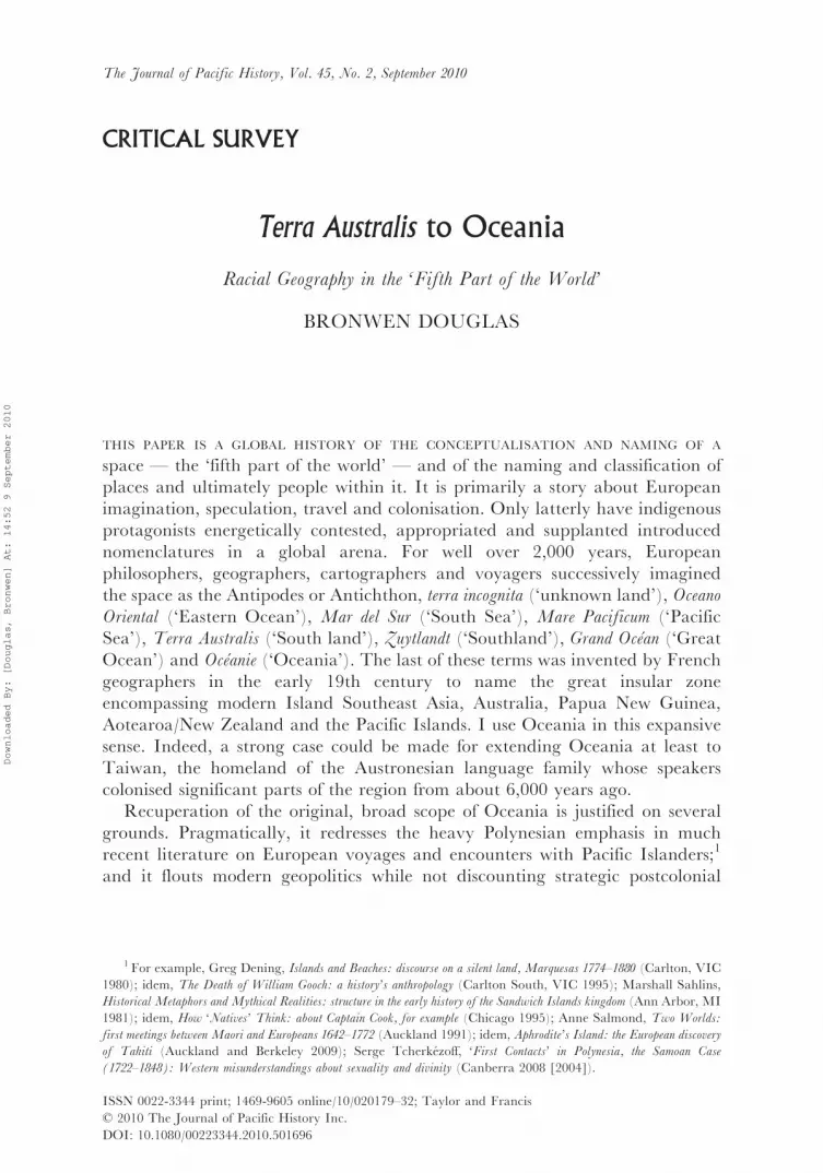
On Corsali’s authority, a series of maps produced from 1569 by Mercator,Ortelius, and the Dutchman Petrus Plancius persistently associate the land ofPiccinacoli with New Guinea — sometimes depicted as an island, sometimes as amassive peninsula jutting north from Terra Australis (Figures 4 and 5).28 Thegreat island had been visited by several Portuguese and Spanish expeditions fromthe mid-1520s but was only named in 1545 by the Spaniard Inigo Ortiz de Retes.According to Antonio Galvao — captain of the Portuguese station in theMoluccas in the late 1530s and author of an early history of voyages — Reteschose the name New Guinea ‘because’ the people he saw along the north coast
FIGURE 5: Claes Jansz. Visscher after Petrus Plancius, Insvlae Molvccae . . . , detail, engraving([Amsterdam] 1617), Mitchell Library, State Library of NSW, Sydney, ZM2 470/1617/1.
Available online at http://library.sl.nsw.gov.au/�S2record¼b2056881�S2 (accessed 15 July 2009).
27 Andrea Corsali, ‘Letter of Andrea Corsali [Cochin, 6 January 1515] [Lettera di Andrea Corsali allo
Illustrissimo Signore Duca Juliano de Medici, Venuta Dellindia del mese di Octobre Nel M.D. XVI]’,manuscript copy (Venice c. 1516), National Library of Australia, Canberra, MS 7860. Available online at
http://nla.gov.au/nla.ms-ms7860 (accessed 23 November 2008), my emphasis. Corsali’s letter was privately
printed in Florence in 1516; the manuscript copy held by the National Library of Australia was made in Venice
at about the same time.28 For example, Gerard Mercator, ‘Nova et avcta orbis terrae’, plates 7, 13; Michael Mercator, America siue
India Nova ad magnae Gerardi Mercatoris aui vniversalis imitationem in compendium redacta, engraving (Duysburgensem
1595), National Library of Australia, Canberra, MAP NK 2078. Available online at http://nla.gov.au/nla.map-
nk2078; Ortelius, ‘Americae’; idem, ‘Indiae orientalis’; idem, ‘Maris Pacifici, (quod vulgo Mar del Zur)’, inidem, Theatrvm orbis terrarvm, engraving (4th edn, Antwerp 1592 [1589]), map 6, National Library of Australia,
Canberra, MAP NK 1528. Available online at http://nla.gov.au/nla.map-nk1528; Claes Jansz Visscher after
Petrus Plancius, Insvlae Molvccae . . . , engraving ([Amsterdam] 1617), Mitchell Library, State Library of NSW,Sydney, ZM2 470/1617/1. Available online at http://library.sl.nsw.gov.au/record=b2056881�S2 (all accessed
15 July 2009).
TERRA AUSTRALIS TO OCEANIA 189
Downloaded By: [Douglas, Bronwen] At: 14:52 9 September 2010

were ‘preta & de cabelo reuolto’ (‘black with twisted hair’).29 In Plancius’s 1617map of the Moluccas (Figure 5), New Guinea is annotated as Corsali’s Terra de
Piccinacoli. However, this text seems also to suggest, ‘on the authority of seamen’(‘a nautis sic dicta’), that the name New Guinea derived not from the appearanceof the inhabitants but from that of the coastline, deemed ‘very similar’ to the‘territories of African Guinea’.30 Whatever Retes’s explicit inspiration, hisnomenclature eternalised by analogy the recurrent identification of the island’sinhabitants with West Africans who, in Iberian and later general Europeanthinking, epitomised barbarism and rightful potential for enslavement.An important innovation in the 1587 French edition of Ortelius’s map‘America’, absent from earlier versions and from Mercator’s contemporaryworks, is the inclusion of ‘Insulæ Salomonis’ to the east of New Guinea, thusinscribing the highly unstable ‘discovery’ of the Solomon Islands by the SpaniardAlvaro de Mendana during his return voyage across the Mar del Sur from Peruin 1567–69.31
As Chris Ballard has shown with respect to New Guinea (which wasencountered early by Europeans but long remained their ‘last unknown’), beliefin the existence of innately short-statured populations, or pygmies, would be themost tenacious of the classical, medieval, and Renaissance fables that populatedunknown regions of the earth with marvels and monsters.32 I by no means seek totrace an unbroken or unproblematic genealogy from stories about little peopletold to 16th-century Portuguese navigators by inhabitants of the East Indies tothe ‘pygmies’ with which some travellers, archaeologists and anthropologistsfrom the early 19th century onwards have peopled the interior of parts of the
29Antonio Galvao [Galvano], The Discoveries of the World, from their First Original unto the Year of Our Lord
1555 . . . , ed. Charles Ramsey Drinkwater Bethune (London 1862 [1563]), 203, 238–9.30Visscher, Insvlae Molvccae, my emphasis. Thanks to Hilary Howes and friends for help in translating the
following passage: ‘Nova Guinea a nautis sic dicta, quod eius litora, locorumque facies Guineæ Africanæ multum sunt similia’
(e-mail, 19 May 2009). The caption and text of an earlier map by the Belgian cartographer Cornelis de Jode is
in fact quite explicit that New Guinea was named for a supposed spatial rather than a human resemblance.Cornelis de Jode, Novæ Gvineæ forma, & situs, engraving (Antwerp 1593), National Library of Australia,
Canberra, MAP RM 389. Available online at http://nla.gov.au/nla.map-rm389 (accessed 15 June 2010).31Ortelius, ‘Americae sive novi orbis, nova descriptio’, in idem, Theatre de l’univers, contenant les cartes de tout le
monde . . . , engraving (Antwerp 1587), map 5, Cartographica Neerlandica Background for Ortelius Map No. 11.
Available online at http://www.orteliusmaps.com/book/ort11.html. See also Jan van Doetichum after Petrus
Plancius, ‘Orbis terrarvm typvs de integro multis in locis emendatus’ (1594), in Jan Huygen van Linschoten,
Nauigatio ac itinerarium Iohannis Hugonis Linscotani in Orientalem siue Lusitanorum Indiam . . . , map 1, engraving(Hagae-Comitis 1599), National Library of Australia, Canberra, MAP RM 144. Available online at http://
nla.gov.au/nla.map-rm144; Visscher, Insvlae Molvccae (Figure 5). Cf. Rumold Mercator, Orbis terrae compendiosa
descriptio . . . , engraving (Duysburghi Clivorum 1587), Dixson Library, State Library of NSW, Sydney, ZM2
100a/1587/1. Available online at http://library.sl.nsw.gov.au/record=b2068325�S2; Michael Mercator,America siue India Nova (all accessed 15 July 2009). For Mendana’s voyage, see Alvaro de Mendana, ‘Esta es
la relacion y suceso de las cosas que an sucedido y pasado en el descumbrimiento de las ylsas, que el illustre
Senor Alvaro Davendana fue a descubrir, ano de 156[7] anos hasta el ano de 1568 . . . ’, in Celsus Kelly (ed.),
Austrialia franciscana, vol. 3, Documentos sobre la Expedicion de Alvaro de Mendana a las Islas de Salomon en el Mar del Sur
(1567–1569) (Madrid 1967), 181–245.32 Chris Ballard, ‘Collecting Pygmies: the ‘‘Tapiro’’ and the British Ornithologists’ Union expedition to
Dutch New Guinea, 1910–1911’, in Michael O’Hanlon and Robert L. Welsch (eds), Hunting the Gatherers:
ethnographic collectors, agents and agency in Melanesia, 1870s–1930s (New York and Oxford 2000), 127–54; idem,
‘Strange alliance: Pygmies in the colonial imaginary’, World Archaeology, 38 (2006), 133–51.
190 JOURNAL OF PACIFIC HISTORY
Downloaded By: [Douglas, Bronwen] At: 14:52 9 September 2010
Malay Archipelago and New Guinea.33 Yet the enduring force of the potentamalgam of European prejudice and local rumour is evident not only in theidentification of New Guinea as Terra de Piccinacoli by Renaissance map-makersbut also much later in the purportedly scientific discourse of race. Thus NewGuinea was confidently made the abode of ‘a dwarf African negro’ by a 19th-century English philologist and anthropologist who had never been there but hadconsiderable experience in the Malay Archipelago as an East India Companyofficial. And a mid-20th-century anthropologist with lengthy fieldworkcredentials in Bougainville could repeatedly claim, with equal assurance, thatthe ‘virtually inaccessible mountains’ of New Guinea and nearby Bougainvillewere populated by people whose ‘Negrito ancestry’ was ‘documented by theirpygmy size’.34
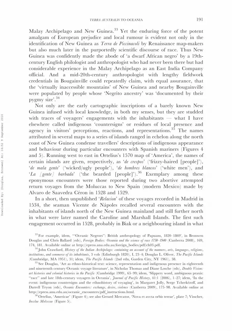
Not only are the early cartographic inscriptions of a barely known NewGuinea infused with local knowledge, in both my senses, but they are studdedwith traces of voyagers’ engagements with the inhabitants — what I haveelsewhere called indigenous ‘countersigns’ or residues of local presence andagency in visitors’ perceptions, reactions, and representations.35 The namesattributed in several maps to a series of islands ranged in echelon along the northcoast of New Guinea condense travellers’ descriptions of indigenous appearanceand behaviour during particular encounters with Spanish mariners (Figures 4and 5). Running west to east in Ortelius’s 1570 map of ‘America’, the names ofcertain islands are given, respectively, as ‘de crespos’ (‘frizzy-haired [people]’),‘de mala gente’ (‘wicked/ugly people’), ‘de hombres blancos’ (‘white men’), and‘La [gente] barbada’ (‘the bearded [people]’).36 Exemplary among theseeponymous encounters were those reported during two abortive attemptedreturn voyages from the Moluccas to New Spain (modern Mexico) made byAlvaro de Saavedra Ceron in 1528 and 1529.
In a short, then unpublished ‘Relacion’ of these voyages recorded in Madrid in1534, the seaman Vicente de Napoles recalled several encounters with theinhabitants of islands north of the New Guinea mainland and still further northin what were later named the Caroline and Marshall Islands. The first suchengagement occurred in 1528, probably in Biak or a neighbouring island in what
33 For example, idem, ‘‘‘Oceanic Negroes’’: British anthropology of Papuans, 1820–1869’, in Bronwen
Douglas and Chris Ballard (eds), Foreign Bodies: Oceania and the science of race 1750–1940 (Canberra 2008), 169,174, 181. Available online at http://epress.anu.edu.au/foreign_bodies/pdf/ch03.pdf.
34 John Crawfurd, History of the Indian Archipelago: containing an account of the manners, arts, languages, religions,
institutions, and commerce of its inhabitants, 3 vols (Edinburgh 1820), I, 23–4; Douglas L. Oliver, The Pacific Islands
(Cambridge, MA 1951), 31; idem, The Pacific Islands (2nd edn, Garden City, NY 1961), 38.35 See Douglas, ‘Art as ethno-historical text: science, representation and indigenous presence in eighteenth
and nineteenth century Oceanic voyage literature’, in Nicholas Thomas and Diane Losche (eds), Double Vision:
art histories and colonial histories in the Pacific (Cambridge 1999), 65–99; idem, ‘Slippery word, ambiguous praxis:
‘‘race’’ and late 18th-century voyagers in Oceania’, Journal of Pacific History, 41:1 (2006), 1–27; idem, ‘In theevent: indigenous countersigns and the ethnohistory of voyaging’, in Margaret Jolly, Serge Tcherkezoff, and
Darrell Tryon (eds), Oceanic Encounters: exchange, desire, violence (Canberra 2009), 175–98. Available online at
http://epress.anu.edu.au/oceanic_encounters/pdf_instructions.html.36Ortelius, ‘Americae’ (Figure 4); see also Gerard Mercator, ‘Nova et avcta orbis terrae’, plate 7; Visscher,
Insvlae Molvccae (Figure 5).
TERRA AUSTRALIS TO OCEANIA 191
Downloaded By: [Douglas, Bronwen] At: 14:52 9 September 2010
is now Indonesia’s Papua Province, where the Spanish met ‘a black, nakedpeople with frizzy hair, bearing arms of iron and swords’. They traded food withthe visitors during a stay of about a month and became the cartographers’‘crespos’. The Spanish then coasted to the southeast and were eventually blownnorth to another island, probably Manus (in Papua New Guinea), where‘natives’ in canoes came out to the ship firing arrows. Napoles called them ‘ablack, naked, ugly people’. The syntax of this passage is significant: the epithet feo(‘ugly’) — unusually derogatory for this author — follows hard on mention of adoubtless alarming attack and can be taken as a countersign of bafflingindigenous agency. The map-makers duly inscribed the event in the moresweeping phrase ‘mala gente’ — malo (from L. malus, ‘bad, wicked, ugly,deformed’) at that time signified both ‘ugly’ appearance and ‘wicked’behaviour.37 Having seized three men from this place, Saavedra sailed ‘about250 leagues’ (approximately 1,500 km) and reached more islands in 7� northlatitude. They were ‘populated by white, bearded people’ who also came out tothe ship in canoes and threatened the visitors with slingstones.38 Displaced fromthe Carolines to an island near the New Guinea mainland, they are thecartographers’ ‘bearded’ men.
The three captives spent the following 12 months in Spanish company andwere aboard Saavedra’s vessel when he returned to their island exactly a yearlater. Two leapt overboard on first sight of land but the third, who had beenbaptised and learned some Spanish, swam ashore with the intention of mediatingbetween his countrymen and his new friends. To the sailors’ horror, theinhabitants killed him in the water. In a very early instance of a kind of rhetoricalshift typically stimulated in voyagers’ accounts by indigenous behaviour,39 thesethree men were verbally humanised by familiarity. At this point in Napoles’snarrative they are simply ‘indios’, no longer black or ugly, and there is a poignantnote in his recollection of the Spaniards’ inability to meet their fellow Christian’scries for help: ‘y en fin, lo mataron’ (‘and in short, they killed him’). Continuingtheir course to the northeast, the voyagers eventually reached several low islandsin about 11� north, probably Enewetak in the Marshalls, where they recuperatedfor a week and enjoyed friendly exchange relations with the inhabitants who
37Vicencio de Napoles, ‘Relacion . . .del viaje que hizo la armada que Hernan Cortes envio en busca de las
islas de la Especieria’, in Luis Torres de Mendoza (ed.), Coleccion de documentos ineditos, relativos al descubrimiento,
conquista y organizacion de las antiguas posessiones Espanolas en America y Oceanıa . . . (Madrid 1866), V, 89; Real
Academia Espanola, Diccionario de la lengua castellana . . . , 6 vols (Madrid 1726–39), IV, 465–6. Available online
at http://buscon.rae.es/ntlle/SrvltGUILoginNtlle (accessed 16 July 2009).38Napoles, ‘Relacion’, 89–90. Historians disagree on the identification of these islands. Whereas Francis
Hezel was certain that they ‘must have been either Ponape [modern Pohnpei] or one of its outliers’, Andrew
Sharp was equally definite that they were ‘not Ponape’ but might have been one of several groups of atolls in
the eastern Carolines to the southwest, south or southeast of Pohnpei. However, Spate’s cartographic
reconstruction puts the ship’s route far to the west of Pohnpei. Francis X. Hezel, The First Taint of Civilization: a
history of the Caroline and Marshall Islands in pre-colonial days, 1521–1885 (Honolulu 1983), 16; Andrew Sharp, The
Discovery of the Pacific Islands (Oxford 1960), 21; Spate, Pacific Since Magellan, vol. 1, The Spanish Lake (Canberra
1979), 92, Fig. 12.39 See, for example, Douglas, ‘Voyages, encounters, and agency in Oceania: Captain Cook and Indigenous
people, History Compass, 6:3 (2008), 720, 723, 725.
192 JOURNAL OF PACIFIC HISTORY
Downloaded By: [Douglas, Bronwen] At: 14:52 9 September 2010

were ‘white and painted’ (tattooed). The women were ‘beautiful’ with ‘black,long’ hair.40 Also relocated to the vicinity of New Guinea, these people are thecartographers’ ‘hombres blancos’.
The early 17th-century Spanish historian Antonio de Herrera y Tordesillas,who had certainly read Napoles’s account, marvelled that the voyagers had seen‘men so different in colour’ within ‘so short a distance’.41 Herrera’s casual remarkand the map-makers’ vivid appropriation of the voyagers’ broad descriptiveterminology were rehearsed repeatedly over the next four centuries. Most suchreinscriptions are anachronistic: they address contemporary preoccupationsusing contemporary lexicons. The early 19th-century voyage historian JamesBurney was sensitised to nuances of human skin colour during two expeditions inOceania under James Cook. He specified that the Spanish and the Portugueseoften described the ‘light copper-coloured complexion’ as ‘white’. Alert to anemergent dual classification of Oceanian humanity (see below), Burneyattributed the cartographic recourse to the terms crespos and hombres blancos tothe need to distinguish ‘Indians’ of the latter complexion from the ‘black andwoolly-headed Indians’.42 The 19th-century Spanish historian MartınFernandez Navarrete took the reality of racial difference for granted intransposing Herrera’s expression of personal surprise to the voyagers themselves:‘the Castilians were astonished to see people of such different colour in so short adistance’. The 20th-century American historian Ione Stuessy Wright did likewisethough neither Napoles’s ‘Relacion’ nor any other text cited supports thisassumption. In an excess of anachronism, Wright reconstituted the Spanishdescriptive comparison into modern discrete racial categories: they were, shepronounced, ‘amazed’ by the ‘contrast between the light-skinned, beardedMicronesians and the black, frizzly-haired Papuans who lived so near’. Thefatuity of this racial discrimination is patent in a later book in which Wrightmistakenly reformulated the contrast as ‘between the light-skinned, beardedMelanesian natives and the Papuans whom they had left so recently’. In 19th-century racial theory (if not in modern linguistics), ‘Melanesian’ and ‘Papuan’were more or less synonymous terms!43
Over more than 200 years, Terra Australis loomed more or less large inEuropean cartography, geographical imaginings and explorational goals.44 Thefirst heyday of Terra Australis encompassed the voyages across the Mar del Sur of
40Galvao, Discoveries, 177; Napoles, ‘Relacion’, 91–2. Sharp and Hezel here agree on the insular
identification. Hezel, First Taint, 16; Sharp, Discovery, 21–2.41 Antonio de Herrera y Tordesillas, Historia general de los hechos de los Castellanos en las Islas i Tierra firme del
mar Oceano . . . , 4 vols (Madrid 1601–15), II, decada 4: 61.42 James Burney, A Chronological History of the Discoveries in the South Seas or Pacific Ocean, 5 vols (London
1803–17), I, 152, note y.43Martın Fernandez Navarrete, ‘Acaecimientos en Molucas de los castellanos de la nao Victoria de la
expedicion de Loaisa, y de la nao Florida del mando de Alvaro de Sayavedra’, in idem, Coleccion de los viages y
descubrimientos, que hicieron por mar los Espanoles desde fines del siglo XV . . . , vol. 5, Expediciones al Maluco: Viages de
Loaisa y de Saavedra (Madrid 1837), 124, my emphasis; Ione Stuessy Wright, ‘The first American voyage across
the Pacific, 1527–1528: the voyage of Alvaro de Saavedra Ceron’, Geographical Review, 29 (1939), 480; idem,Voyages of Alvaro de Saavedra Ceron 1527–1529 (Coral Gables, FL 1951), 52–3, my emphasis.
44 See Eisler, Furthest Shore; Schilder, Australia Unveiled; Wroth, ‘Early cartography’, 168–200.
TERRA AUSTRALIS TO OCEANIA 193
Downloaded By: [Douglas, Bronwen] At: 14:52 9 September 2010
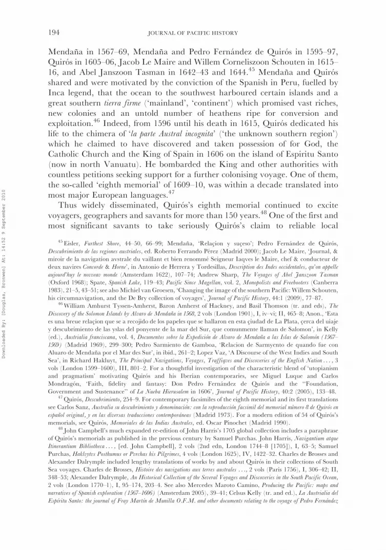
Mendana in 1567–69, Mendana and Pedro Fernandez de Quiros in 1595–97,Quiros in 1605–06, Jacob Le Maire and Willem Corneliszoon Schouten in 1615–16, and Abel Janszoon Tasman in 1642–43 and 1644.45 Mendana and Quirosshared and were motivated by the conviction of the Spanish in Peru, fuelled byInca legend, that the ocean to the southwest harboured certain islands and agreat southern tierra firme (‘mainland’, ‘continent’) which promised vast riches,new colonies and an untold number of heathens ripe for conversion andexploitation.46 Indeed, from 1596 until his death in 1615, Quiros dedicated hislife to the chimera of ‘la parte Austral incognita’ (‘the unknown southern region’)which he claimed to have discovered and taken possession of for God, theCatholic Church and the King of Spain in 1606 on the island of Espiritu Santo(now in north Vanuatu). He bombarded the King and other authorities withcountless petitions seeking support for a further colonising voyage. One of them,the so-called ‘eighth memorial’ of 1609–10, was within a decade translated intomost major European languages.47
Thus widely disseminated, Quiros’s eighth memorial continued to excitevoyagers, geographers and savants for more than 150 years.48 One of the first andmost significant savants to take seriously Quiros’s claim to reliable local
45 Eisler, Furthest Shore, 44–50, 66–99; Mendana, ‘Relacion y suceso’; Pedro Fernandez de Quiros,
Descubrimiento de las regiones austriales, ed. Roberto Ferrando Perez (Madrid 2000); Jacob Le Maire, ‘Journal, &
miroir de la navigation avstrale du vaillant et bien renomme Seigneur Iaqves le Maire, chef & conducteur dedeux navires Concorde & Horne’, in Antonio de Herrera y Tordesillas, Description des Indes occidentales, qu’on appelle
aujourd’huy le novveav monde (Amsterdam 1622), 107–74; Andrew Sharp, The Voyages of Abel Janszoon Tasman
(Oxford 1968); Spate, Spanish Lake, 119–43; Pacific Since Magellan, vol. 2, Monopolists and Freebooters (Canberra1983), 21–5, 43–51; see alsoMichiel van Groesen, ‘Changing the image of the southern Pacific: Willem Schouten,
his circumnavigation, and the De Bry collection of voyages’, Journal of Pacific History, 44:1 (2009), 77–87.46William Amhurst Tyssen-Amherst, Baron Amherst of Hackney, and Basil Thomson (tr. and eds), The
Discovery of the Solomon Islands by Alvaro de Mendana in 1568, 2 vols (London 1901), I, iv–vi; II, 465–8; Anon., ‘Estaes una breue relacion que se a recojido de los papeles que se hallaron en esta ciudad de La Plata, cerca del uiaje
y descubrimiento de las yslas del ponyente de la mar del Sur, que comunmente llaman de Salomon’, in Kelly
(ed.), Austrialia franciscana, vol. 4, Documentos sobre la Expedicion de Alvaro de Mendana a las Islas de Salomon (1567–
1569) (Madrid 1969), 299–300; Pedro Sarmiento de Gamboa, ‘Relacion de Sarmyento de quando fue conAluaro de Mendana por el Mar des Sur’, in ibid., 261–2; Lopez Vaz, ‘A Discourse of the West Indies and South
Sea’, in Richard Hakluyt, The Principal Navigations, Voyages, Traffiqves and Discoveries of the English Nation . . . , 3
vols (London 1599–1600), III, 801–2. For a thoughtful investigation of the characteristic blend of ‘utopianismand pragmatism’ motivating Quiros and his Iberian contemporaries, see Miguel Luque and Carlos
Mondragon, ‘Faith, fidelity and fantasy: Don Pedro Fernandez de Quiros and the ‘‘Foundation,
Government and Sustenance’’ of La Nueba Hierusalem in 1606’, Journal of Pacific History, 40:2 (2005), 133–48.47Quiros, Descubrimiento, 254–9. For contemporary facsimiles of the eighth memorial and its first translations
see Carlos Sanz, Australia su descubrimiento y denominacion: con la reproduccion facsimil del memorial numero 8 de Quiros en
espanol original, y en las diversas traducciones contemporaneas (Madrid 1973). For a modern edition of 54 of Quiros’s
memorials, see Quiros, Memoriales de las Indias Australes, ed. Oscar Pinochet (Madrid 1990).48 John Campbell’s much expanded re-edition of John Harris’s 1705 global collection includes a paraphrase
of Quiros’s memorials as published in the previous century by Samuel Purchas. John Harris, Navigantium atque
Itinerantium Bibliotheca . . . , [ed. John Campbell], 2 vols (2nd edn, London 1744–8 [1705]), I, 63–5; Samuel
Purchas, Haklvytvs Posthumus or Pvrchas his Pilgrimes, 4 vols (London 1625), IV, 1422–32. Charles de Brosses and
Alexander Dalrymple included lengthy translations of works by and about Quiros in their collections of SouthSea voyages. Charles de Brosses, Histoire des navigations aux terres australes . . ., 2 vols (Paris 1756), I, 306–42; II,
348–53; Alexander Dalrymple, An Historical Collection of the Several Voyages and Discoveries in the South Pacific Ocean,
2 vols (London 1770–1), I, 95–174, 203–4. See also Mercedes Maroto Camino, Producing the Pacific: maps and
narratives of Spanish exploration (1567–1606) (Amsterdam 2005), 39–41; Celsus Kelly (tr. and ed.), La Austrialia del
Espıritu Santo: the journal of Fray Martın de Munilla O.F.M. and other documents relating to the voyage of Pedro Fernandez
194 JOURNAL OF PACIFIC HISTORY
Downloaded By: [Douglas, Bronwen] At: 14:52 9 September 2010

knowledge was the renowned Dutch cartographer and publisher Hessel Gerritszwho included a Dutch translation of the eighth memorial in a collection ofprimarily Arctic voyages. Gerritsz’s work contains a mappa mundi in twohemispheres, in which a hypothetical continental coastline meanders northwestfrom the Strait of Magellan across the ‘Mar del Zur’, but solidifies south of theSolomon Islands in what Gerritsz’s annotation materialises as ‘the land recentlydiscovered’ by Quiros, ‘formerly known’ as Terra Australis incognita (and nowpresumably cognita).49 In mid-Atlantic en route to south America in October1615, the Dutchman Le Maire informed his crew that the goal of their voyagewas ‘to go to’ the Southland. He read Quiros’s memorial aloud ‘to encouragethem’ and noted that the seamen, especially, rejoiced because they hoped ‘thatsuch a noble voyage could only bring them great fame and profit’.50
Yet the Englishman Francis Drake, who circumnavigated the world in1577–80, had already cast serious doubt on the status of Tierra del Fuego as anappendage of a ‘continent or maine land’. Driven southwards by storms to about56�, Drake ‘fell in with the vttermost part of land towards the South Pole . . . ,without which there is no maine nor Iland to be seene to the Southwards, butthat the Atlanticke Ocean and the South Sea, meete in a most large and freescope’. In his world map of 1599, on the authority of Drake’s ‘discoverie’, theEnglish mathematician and cartographer Edward Wright dismissed thesupposed continent as ‘nothing els but broken land and Ilands’ and showedonly empty sea to their south.51 In 1622, in the wake of Le Maire’s andSchouten’s voyage, Gerritsz also reneged on the reality of a great southerncontinent. Le Maire had proved Tierra del Fuego to be an island by passingthrough the strait that bears his name and around Cape Horn, which he named.He then crossed the Zuyd Zee (‘South Sea’) in more southerly latitudes than hisSpanish predecessors, but had no more success than they in finding the continentin which he and they more or less fervently believed. Accordingly, Gerritsz’s mapof Mar del Svr, Mar Pacifico replaced Terra Australis by a stormy seascape.52
By the 1660s, following the voyages of the Dutchman Tasman, another Dutchcartographer, Pieter Goos, expressed a scepticism shared by several of his
( footnote continued)
de Quiros to the South Seas (1605–1606) . . . , 2 vols (Cambridge 1966), I, 5; Sanz, Australia, [15]–17; Schilder,
Australia Unveiled, 29.49Hessel Gerritsz, Beschryvinghe vander Samoyeden Landt in Tartarien . . . (Amsterdam 1612), my emphasis. See
Schilder, Australia Unveiled, 18–20, and Sanz, Australia, 19, for reproductions of Gerritsz’s world map. Sanz
(Australia, 71–80) also published a facsimile of Gerritsz’s Dutch edition of the eighth memorial. Thanks to
Hilary Howes for help in translating Gerritsz’s Latin inscription about Quiros (e-mail, 23 July 2008). Myemphasis.
50 Le Maire, ‘Journal’, 117.51 Francis Fletcher, ‘The voyage about the world, by Sir Francis Drake’, in W.S.W. Vaux (ed.), The World
Encompassed by Sir Francis Drake, Being his next Voyage to that to Nombre de Dios (London 1854 [1628]), 87; EdwardWright, ‘A chart of the world on Mercator’s projection’, in Hakluyt, Principal Navigations, III, in Lewis & Clark:
the Maps of Exploration 1507–1814, Albert H. and Shirley Small Special Collections Library, University of
Virginia, Charlottesville, VA. Available online at http://www2.lib.virginia.edu/exhibits/lewis_clark/novus_or-bis3.html (accessed 18 July 2009).
52 Schilder, Australia Unveiled, 32–7, 288–9, map 23.
TERRA AUSTRALIS TO OCEANIA 195
Downloaded By: [Douglas, Bronwen] At: 14:52 9 September 2010

colleagues in rejecting the ‘cal[l] for a fifth part of the world Terra Australis orMagellanica’. His world map reduced Tierra del Fuego to ‘a haep of Ilands’;restricted ‘Terra Australis’ to ‘those Countreys in the South of Nova Guinea’recently visited by Tasman (‘Hollandia Nova and Nova Zelandia’); and leftblank the far southern portion of the globe.53 Yet, despite its ever-shrinkingreality, the mirage of Terra Australis captivated savants up to and including themid-18th-century compilers of collections of voyage texts, John Campbell,Charles de Brosses, and Alexander Dalrymple.54 Moreover, Terra Australis
remained a well-nigh universal goal for maritime exploring expeditions until thereturn in 1775 of Cook’s iconoclastic second voyage which definitively reduced itto roughly the modern contours of Australia and Antarctica.
Terra Australis to Oceanie
Despite the practical efforts of navigators and the intellectual interest of savants,much of the fifth part of the world remained almost unknown andundifferentiated in Europe until the mid-18th century. The subsequent namingand division of the region was largely a French project. Brosses proposed theearliest regional classification of the ‘Terres australes’ (‘southern lands’) in 1756,and his speculative program for discovery, commerce and settlement therehelped inspire the great French and British global circumnavigations of the1760s.55 Though a disciple of the classical ‘counterweight’ theory of a necessary‘immense’ southern continent, he insisted on the need to ‘fix’ our wavering visionby drawing firm boundaries. Accordingly, he divided this ‘unknown southernworld’ into three great regions. He adapted the old term Magellanica to name as‘Magellanique’ a purely conjectural land mass to the south of South America.‘Australasie’ (‘Australasia’) and ‘Polynesie’ (‘Polynesia’) were neologisms. The first,also largely speculative, was fragmentarily materialised in actual places seen byvoyagers in New Guinea, New Britain, New Holland (mainland Australia), VanDiemen’s Land (Tasmania), New Zealand and Espiritu Santo. Polynesie
encompassed ‘everything within the vast Pacific Ocean’ — what are nowPolynesia, Micronesia and much of Island Melanesia.56
In 1804, when the region’s broad contours were known to Europeans, thegeographers Edme Mentelle and Conrad Malte-Brun suggested the name
53 Pieter Goos, The Sea-Atlas or the Watter-World, wherein are Described all the Sea Coasts of the Knowne
World . . . (Amsterdam 1668 [1666]), [7], map 1.54 Brosses, Histoire, I, 2–5, 13–16; Dalrymple, Historical Collection, I, xxii–xxx, 95–7; Harris, Navigantium, I,
62–5; Pierre-Louis Moreau de Maupertuis, ‘Lettre sur le progres des sciences’, in idem, Œuvres de Maupertuis, 4
vols (Lyon 1768 [1752]), 378–86.55 Brosses’s interest had avowedly been sparked by a letter on the ‘progress of the sciences’ written in 1752 to
Frederick II of Prussia by the French polymath Pierre-Louis Moreau de Maupertuis who promoted the searchfor the Terres australes as the most urgent and worthy object of royal scientific patronage. Brosses, Histoire, I, i,
2–4; Maupertuis, ‘Lettre’, 375–86; see John Dunmore, French Explorers in the Pacific, 2 vols (Oxford 1965–9), I,
45–50; Tom Ryan, ‘‘‘Le President des Terres Australes’’: Charles de Brosses and the French Enlightenmentbeginnings of Oceanic anthropology’, Journal of Pacific History, 37:2 (2002), 157–86.
56 Brosses, Histoire, I, 13–16, 76–80.
196 JOURNAL OF PACIFIC HISTORY
Downloaded By: [Douglas, Bronwen] At: 14:52 9 September 2010
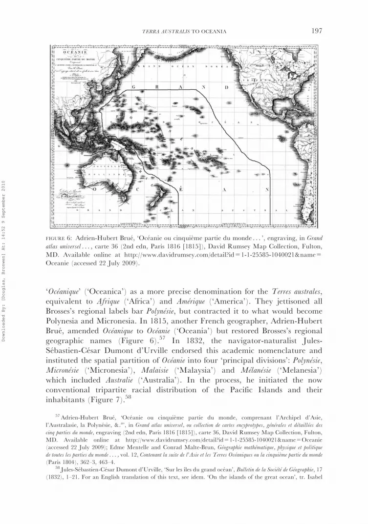
‘Oceanique’ (‘Oceanica’) as a more precise denomination for the Terres australes,equivalent to Afrique (‘Africa’) and Amerique (‘America’). They jettisoned allBrosses’s regional labels bar Polynesie, but contracted it to what would becomePolynesia and Micronesia. In 1815, another French geographer, Adrien-HubertBrue, amended Oceanique to Oceanie (‘Oceania’) but restored Brosses’s regionalgeographic names (Figure 6).57 In 1832, the navigator-naturalist Jules-Sebastien-Cesar Dumont d’Urville endorsed this academic nomenclature andinstituted the spatial partition of Oceanie into four ‘principal divisions’: Polynesie,Micronesie (‘Micronesia’), Malaisie (‘Malaysia’) and Melanesie (‘Melanesia’)which included Australie (‘Australia’). In the process, he initiated the nowconventional tripartite racial distribution of the Pacific Islands and theirinhabitants (Figure 7).58
FIGURE 6: Adrien-Hubert Brue, ‘Oceanie ou cinquieme partie du monde . . . ’, engraving, in Grand
atlas universel . . . , carte 36 (2nd edn, Paris 1816 [1815]), David Rumsey Map Collection, Fulton,
MD. Available online at http://www.davidrumsey.com/detail?id=1-1-25585-1040021&name=
Oceanie (accessed 22 July 2009).
57 Adrien-Hubert Brue, ‘Oceanie ou cinquieme partie du monde, comprenant l’Archipel d’Asie,
l’Australasie, la Polynesie, &.a’, in Grand atlas universel, ou collection de cartes encyprotypes, generales et detaillees des
cinq parties du monde, engraving (2nd edn, Paris 1816 [1815]), carte 36, David Rumsey Map Collection, Fulton,
MD. Available online at http://www.davidrumsey.com/detail?id=1-1-25585-1040021&name=Oceanie(accessed 22 July 2009); Edme Mentelle and Conrad Malte-Brun, Geographie mathematique, physique et politique
de toutes les parties du monde . . . , vol. 12, Contenant la suite de l’Asie et les Terres Oceaniques ou la cinquieme partie du monde
(Paris 1804), 362–3, 463–4.58 Jules-Sebastien-Cesar Dumont d’Urville, ‘Sur les ıles du grand ocean’, Bulletin de la Societe de Geographie, 17
(1832), 1–21. For an English translation of this text, see idem. ‘On the islands of the great ocean’, tr. Isabel
TERRA AUSTRALIS TO OCEANIA 197
Downloaded By: [Douglas, Bronwen] At: 14:52 9 September 2010

Naming and classifying people
Over the first 250 years of European encounters in the fifth part of the world, thevocabularies applied to the inhabitants gradually became more specific, morediscriminative and more categorical. They also successively referenced priorexperience and precedents in Africa, Asia, the Americas and, ultimately, Oceaniaitself. The word ‘race’ (then a concrete genealogical term connoting a nation orpeople of common ancestry) was hardly used before the mid-18th century; whilethe modern biological sense of a race (denoting permanent, innate, collectivephysical and mental differences) did not emerge until the 1770s.59
FIGURE 7: Ambroise Tardieu, ‘Carte pour l’intelligence du memoire de M. le capitaine d’Urville
sur les ıles du grand ocean (Oceanie)’, engraving, in Jules-Sebastien-Cesar Dumont d’Urville,
Voyage de la corvette l’Astrolabe execute pendant les annees 1826–1827–1828–1829 . . .Atlas historique,[Carte 1] (Paris 1833), National Library of Australia, Canberra, MAP NK 2456/73. Available
online at <http://nla.gov.au/nla.map-nk2456-73> (accessed 22 September 2009).
( footnote continued)
Ollivier, Antoine de Biran and Geffrey Clark, in ‘Dumont d’Urville’s divisions of Oceania: fundamentalprecincts or arbitrary constructs?’, special issue, ed. Geoffrey Clark, Journal of Pacific History, 38:2 (2003),
163–74. See also Douglas, ‘‘‘Novus orbis australis’’: Oceania in the science of race, 1750–1850’, in Douglas and
Ballard (ed.), Foreign Bodies, 122–33; Nicholas Thomas, ‘The force of ethnology: origins and significance of the
Melanesia/Polynesia division’, Current Anthropology, 30 (1):27–41; (2), 30–1.59 For my detailed discussion of the history of the concept of ‘race’ and the pivotal discursive shift at the end
of the 18th century from holistic, ‘environmental’ explanations for human variety to the hierarchical
differentiation of biologically determined races, see Douglas, ‘Climate to crania: science and the racialization ofhuman difference’, in Douglas and Ballard (ed.), Foreign Bodies, 33–96. See also Claude Blanckaert, ‘Les
conditions d’emergence de la science des races au debut du XIXe siecle’, in Sarga Moussa (ed.), L’idee de ‘race’
198 JOURNAL OF PACIFIC HISTORY
Downloaded By: [Douglas, Bronwen] At: 14:52 9 September 2010

The subjects of every expanding European realm from the 15th century tookfor granted their own ancestral, religious and civil superiority. However, somaticdifferences ranked fairly low in judgments about national characters, becauseprevailing cosmologies conceived such differences as the transient, adventitiousproducts of climate, humours, life style and station on a single migrating humanspecies. In principle, at least, all human beings were thought to share thepotential for progress towards civility. Values of religion, ‘purity’, estate andcivility authorised 16th-century Iberian bigotry, persecution, and control butnone is aptly reduced to race.60 Yet they converged ominously in the shiftingimport of the descriptor negro, ‘black’: originally a relatively dispassionateadjective, by the mid-16th century it was commonly used as a noun throughoutWestern Europe, negatively charged by the developing identification of‘heathen’, ‘barbarous’, African ‘Negroes’ with chattel slavery.
Sixteenth-century Iberian texts are strikingly poor in collective nouns forhuman beings while plural nouns were largely limited to the all-inclusive ‘people’or ‘men’; the slightly more specific and often synonymous ‘Indians’ or ‘natives’; asweeping religious differentiation of the inhabitants of the East Indies into ‘Moors’(Muslims) and ‘Gentiles’ (‘heathens’); and toponyms such as ‘Moluccans’ or‘Filipinos’. Of particular interest here, as an example of the filtering of localterminology into colonial nomenclature, is the Iberian adoption of the vernaculartoponym ‘Papua’ to designate islands to the east of theMoluccas, their inhabitants,and ultimately New Guinea itself and its people.61 Galvao explained in hisTratado
of 1563 that ‘the Moluccans’ called the ‘men’ of the north coast of New Guinea‘Papuas’ because they were ‘black with frizzled hair’, like the Papuas they knewcloser to home, and that the Portuguese did likewise. Galvao evidently absorbedadverse Moluccan behavioural, as well as physical, stereotypes along with thename: not only were Papuas ‘black people, with dishevelled/twisted hair’, but theypurportedly ate human flesh and were ‘great witches’, ‘given to the devils’. Galvaoimplicitly contrasted them with other people seen by Spaniards who were ‘brownwith flowing hair like the Moluccans’.62
Such nearly juxtaposed representations might well be interpreted asprefiguring the 19th-century racialist dichotomy of black, frizzy-hairedPapuans and brown, straight-haired Malays.63 I suggest, however, that at thispoint the contrasting Portuguese adjectives revolto (‘dishevelled, twisted’) andcorredio (‘flowing’) are more plausibly read as indexing impressions of relative
( footnote continued)
dans les sciences humaines et la litterature (XVIIIe et XIXe siecles) (Paris 2003), 133–49; George W. Stocking, Jr, Race,Culture and Evolution: essays in the history of anthropology (New York, 1968), 13–41.
60 See, for example, Ruth Hill, Hierarchy, Commerce, and Fraud in Bourbon Spanish America: a postal inspector’s
expose (Nashville, TN 2005).61On the vexed semantic history of the local toponym ‘Papua’, its adoption by Portuguese and Spaniards,
and its extension to denote variously stereotyped people as well as places, including New Guinea, see J.H.F.
Sollewijn Gelpke, ‘On the origin of the name Papua’, Bijdragen tot de Taal-, Land- en Volkenkunde, 149 (1993),
318–32; see also Ballard, ‘‘‘Oceanic Negroes’’’.62Galvao, Discoveries, 177, 203–4.63 See Ballard, ‘‘‘Oceanic Negroes’’’.
TERRA AUSTRALIS TO OCEANIA 199
Downloaded By: [Douglas, Bronwen] At: 14:52 9 September 2010

‘barbarism’ and ‘civility’ shared with apprehensive Moluccans than as racialistepithets. Moreover, the erratic continuum between barbarism and civility didnot map neatly on to chromatic variation. Galvao reported an encounter withtattooed ‘white men’ by Saavedra, perhaps in what are now the northernMarshall Islands. The Spaniard was said to have concluded from their‘appearance’ and ‘whiteness’ that they must have originated in China but overa long period of time become ‘tam Barbaros’ (‘so barbaric, wild’) that they nowlacked law, sect and the ‘capacity to raise living things’.64
During the next 200 years, estimations of comparative civility or savagerydisplaced religion as the key criterion for evaluations of non-Europeans by boththe pragmatic Dutch and British and the rationalist French. By the late 16thcentury, the noun ‘Indian’ not only meant ‘native’ in general, but was also usedin the more restricted sense of ‘Indians, both East and West’, sometimes in impliedcontrast to ‘Negro’. This precise phrase appeared a century later in one of thepublished narratives of the widely travelled Englishman William Dampier.However, the Spaniard Luis Vaez de Torres reported that in 1606, in Taumako(Duff Islands, now in southeast Solomon Islands), he saw ‘native Indianscoloured like those of the Indies and others sunburned negroes [negros atecados]and mulattos’.65 For his part, Dampier explicitly compared the ‘Indians’ he metin the Americas, present-day Micronesia and the East Indies with the ‘Negroes’he encountered along the New Guinea coasts: Indians were ‘of a swarthy Coppercolour, with black lank Hair’; Negroes were ‘very black’ and ‘shock Curl-pated’.Such characterisations expressed a deeply ethnocentric contrast rather than aracial opposition: in Dampier’s judgment, both Indians and Negroes might be‘savage’; Negroes more so; but Negroes who traded were less savage than ‘Wild’Indians; and both had the capability to become ‘civilized’ through commerce.66
These fairly even-handed assessments differ markedly from Dampier’s verynegative published words (‘miserablest’, ‘unpleasing’) about the inhabitants ofthe west coast of New Holland whose appearance reminded him of ‘the Negroesof Guinea’ and whose indifference to material inducement — their agency — ledhim to question their capacity for ‘Traffick and useful Intercourse’.67 This was anearly statement of a commonplace nexus drawn by Europeans between lifestyle,
64Galvao, Discoveries, 177–8; Hezel, First Taint, 16. Thanks to Brett Baker for help in translating this passage
(e-mail, 19 July 2009).65William Dampier, ‘A supplement of the voyage round the world: describing the countries of Tonquin, Achin,
Malacca, &c. their product, inhabitants, manners, trade, policy, &c.’, in idem, Voyages and Descriptions, Vol. 2
(London 1699), 176, original emphasis; Luis Vaez de Torres, ‘The letter of Torres, 12 July 1607’, in George F.
Barwick (tr.) and Henry N. Stevens (ed.), New Light on the Discovery of Australia: as revealed by the journal of Captain
Don Diego de Prado y Tovar (London 1930), 224. The term atezado, meaning ‘bronzed’ or ‘darkened by the sun’,
attests to the contemporary belief in climatic causation of skin colour. Thanks to Brett Baker for help in
translating this word (e-mail, 14 October 2008); Real Academia Espanola, Diccionario de la lengua espanola
(Madrid, 2001). Available online at http://buscon.rae.es/draeI/SrvltConsulta?TIPO_BUS=3&LEMA=grado(accessed 10 February 2010).
66 Idem, A New Voyage Round the World . . . (London 1697), 78, 85–6, 297, 325–6, 456–7; idem, A Continuation
of a Voyage to New-Holland, &c. In the Year 1699, Vol. 3, Part 2 (London 1709), 23, 75, 100, 122, 126, 148.67 Idem, New Voyage, 464–9, original emphasis; idem, A Voyage to New-Holland, &c. In the Year, 1699, Vol. 3
(London 1703), 145–9; idem, Continuation, 4.
200 JOURNAL OF PACIFIC HISTORY
Downloaded By: [Douglas, Bronwen] At: 14:52 9 September 2010
material desires and alleged lack of perfectibility, very often to the detriment ofAboriginal Australians. Their refusal to ‘abide our comeing’ or to take ‘notice ofany thing that wee had’ frustrated and insulted Dampier and left countersigns inan early manuscript draft of his first book, as well as in the narratives. Yet thedraft entirely lacks the derogatory epithets for New Hollanders or the stereotypesof the Indian and the Negro that feature in the printed works.68 The differencesbetween Dampier’s draft and his editorially embellished narrative signal, on theone hand, the ongoing imprecision of the available lexicon for humandescription; and, on the other hand, an emergent quest for a more exactterminology to express collective differences. Yet, despite the intermittentrhetorical comparison of Indian and Negro, usually to the latter’s disadvantage,the most common usage of ‘Indian’ well into the 19th century was as a generalsynonym for ‘native’, including ‘Negroes’, as in the previously cited passage byBurney.69
In outlining his pioneer division of the Terres australes, Brosses made noattempt to classify the region’s ‘many different peoples’, since taxonomy was notyet common in European thinking about man. Brosses did, however, identify asupposed ‘difference in the human species’ within a single geographical zone —an anomaly in terms of prevailing climatic explanations for human differences.He explained it in quasi-racial terms, imagining that ‘the native inhabitants’ ofAustralasie were an ‘ancient race’ of ‘frizzy-haired blacks’, identical to ‘the Africannegroes’, who had been displaced or destroyed in Asia by ‘foreign colonies’ ofMalays and only survived in ‘unknown’, ‘Virgin’ lands such as New Holland.70
The first formal classification of ‘the Human Species in the South-Sea Isles’ wasproposed in 1778 by the German naturalist Johann Reinhold Forster, who hadsailed on Cook’s second voyage of 1772–75. Forster empirically identified ‘twogreat varieties of people’, one ‘more fair’, the other ‘blacker’. Burney’sdifferentiation of ‘copper-coloured’ and ‘black’ Indians alluded to thisdistinction. Forster explained their ‘evident difference’ in terms similar toBrosses’s, as a product of the displacement of an ‘aboriginal black race’ by‘successive’ migrations of ‘more civilized’, ‘ancient Malays’. This teleologicalpresumption of the inevitable dispersal or extinction of black autochthons wouldhaunt the subsequent projects of racial taxonomy and colonial settlement in
68 Idem, ‘Voyages Through the South Seas 1681–1691’, manuscript copy annotated by author, Sloane3236, British Library, London; microfilm, 567852, National Library of Australia, Canberra.
69On Dampier’s published differentiation of ‘Indian’ and ‘Negro’ and the general usage of ‘Indian’ by most
other voyagers, see Douglas, ‘Slippery word’.70 Brosses, Histoire, I, 16, 77–80; II, 375–80, original emphasis. Brosses was not the first to proffer such a
conjectural history. In his voyage narrative, Quiros recalled that in Luzon, in the Philippines, there were ‘negros’
(‘blacks’) who were said to be ‘los naturales de la tierra’ (‘the natives of the land’) but who had been driven into
remote corners by invading ‘morillos et indios vizayas, y otras castas de gentes’ (‘little Moors and Visaya Indians, and
other castes of people’). He hypothesised that the ‘perseguidos’ (‘persecuted ones’) had sought and found new placesto settle in New Guinea, the Solomon Islands, and eventually Santa Cruz where he himself saw some ‘black’
inhabitants in 1595. Quiros,Descubrimiento, 89, 100, 175. Thanks to CarlosMondragon for bringing this passage to
my attention. See also CarlosMondragon, ‘Ethnological origins of the ni-Vanuatu ‘‘Other’’: Quiros and the earlySpanish historiography of Asia and the Pacific’, in Frederic Angleviel, et al. (eds), Pedro Fernandez de Quiros et le
Vanuatu: decouverte mutuelle et historiographie d’un acte fondateur, 1606 (Port Vila, Vanuatu 2007), 166.
TERRA AUSTRALIS TO OCEANIA 201
Downloaded By: [Douglas, Bronwen] At: 14:52 9 September 2010

Oceania. But Forster’s classification was not racial in the modern sense of theterm: his unstable lexicon and conviction that human differences were ‘onlyaccidental’ allowed no systematic ranking of varieties, tribes, nations or races (allsynonyms), but located them provisionally along a highly ethnocentric trajectoryof assumed common human potential for development from savagery tocivilisation.71
In contrast to these inchoate, circumstantial discriminations, the termOceanique/Oceanie was inherently racialised from the time of its invention in1804, with skin colour and physical organisation the key differentiae in theelaboration of region-wide racial taxonomies. Indeed, the concept Oceanie is asynecdoche for the fertile marriage of geography and raciology that characterisedthe science of race from its emergence at the dawn of the 19th century until thesecond half of the 20th and beyond.72 Globally, the drive to classify humanbeings had gained momentum from the 1730s when Carl Linnaeus positionedman along with animals within the same ‘natural system’.73 Racial taxonomy, inthe embryonic biological sense of race, dated from the late 1770s, notably insuccessive works by the Germans Immanuel Kant, Samuel ThomasSoemmerring and Johann Friedrich Blumenbach.74 Oceania was scarcelydifferentiated in emergent universal classifications before Mentelle and Malte-Brun’s racial geography of 1803–04. They located the ‘very beautiful’, ‘copper-coloured’, ‘Polynesian race’ in what are now Polynesia and Micronesia andassigned it ‘common origin’ with ‘the Malays of Asia’. They sharplydifferentiated ‘the Polynesians’ from the ‘black race, that we can call OceanicNegroes’, which inhabited New Guinea, Van Diemen’s Land, and what is nowIsland Melanesia, and from a probable ‘distinct third race’ in New Hollandwhich they ranked ‘only a single degree above the brute’ and likened to ‘theapes’.75
71 Johann Reinhold Forster, Observations Made during a Voyage Round the World, on Physical Geography, Natural
History, and Ethic Philosophy (London 1778), 212, 228, 252–84, 353–60. For a detailed exegesis of Forster’s humanclassification, see Douglas, ‘Science and the art of representing ‘‘savages’’: reading ‘‘race’’ in text and image in
South Seas voyage literature’, History and Anthropology, 11:2–3 (1999), 167–75. On Forster’s anthropology in
general, see M.E. Hoare, ‘The neglected ‘‘philosopher’’ of Cook’s second voyage (1772–1775)’, Journal of PacificHistory, 2 (1967), 221–2; Nicholas Thomas, ‘‘‘On the Varieties of the Human Species’’: Forster’s comparative
ethnology’, in Johann Reinhold Forster, Observations Made During a Voyage Round the World, ed. Nicholas
Thomas, Harriet Guest and Michael Dettelbach (Honolulu 1996), xxiii–xl.72 See, for example, Claude Blanckaert, ‘Geographie et anthropologie: une rencontre necessaire (XVIII
e–XIXe
siecle)’, Ethnologie francaise, 34 (2004), 661–9.73 Carl Linnaeus [von Linne], Systema Naturæ, sive Regna tria Naturæ: systematice proposita per classes, ordines,
genera, & species ([Leiden] 1735); idem, Systema Naturæ per Regna tria Naturæ, secundum: classes, ordines, genera,
species, cum characteribus, differentiis, synonymis, locis, vol. 1, [Regnum animale] (10th edn, Holmiæ 1758), 20–5.74 Johann Friedrich Blumenbach, Uber die naturlichen Verschiedenheiten im Menschengeschlechte, tr. Johann
Gottfried Gruber (Leipzig 1798 [1795]); Immanuel Kant, ‘Von den verschiedenen Racen der Menschen’, in
Johann Jacob Engel (ed.), Der Philosoph fur die Welt (Leipzig 1777), II, 125–64; idem, ‘Bestimmung des Begriffs
einer Menschenrace’, Berlinische Monatsschrift, 6, 390–417; Samuel Thomas Soemmerring, Uber die korperliche
Verschiedenheit des Mohren vom Europaer (Mainz 1784).75Malte-Brun, ‘Geographie generale, mathematique et physique’, in Mentelle and Malte-Brun, Geographie
. . . , vol. 1, Contenant la geographie generale, mathematique, physique, politique, et quelques traites generaux (Paris 1803), 548;idem, Precis de la geographie universelle . . . , vol. 4, Description de l’Inde, de l’Oceanique, et de l’Afrique septentrionale (Paris
1813), 229, 244; Mentelle and Malte-Brun, Geographie, XII, 474, 577, 612, 620, original emphasis.
202 JOURNAL OF PACIFIC HISTORY
Downloaded By: [Douglas, Bronwen] At: 14:52 9 September 2010

For the French naval naturalists and artists who dominated the anthropologyof Oceania from 1800 to 1830 (when the first missionary ethnographies began toappear), the global terms of the scientific discourse of race were set by the leadingFrench comparative anatomist Georges Cuvier, who believed that human raceswere separated by real, collective physical differences; that races were innateproducts of biology rather than environment or climate; and that humanintellect and morality were racially determined by anatomy, especially the size ofthe brain, and were thus immutable.76 In the mid-1820s, several naval naturalistswith extensive experience in Oceania, including Dumont d’Urville, devisedclassifications of the populations of the region in response to an offer by theSociete de Geographie de Paris of a prize for a memoir on the ‘various peoples’ ofOceania.77 All used race in its modernist biological sense and rehearsed Cuvier’spartition of humanity into three ‘eminently distinct’ races: ‘white’, ‘yellow’ and‘negro’.78
The most streamlined, the most durable, but the most systematically racialisedof these classifications is that published by Dumont d’Urville in 1832: heproposed the geographical neologism Melanesie, from Greek melas (‘black’), ‘sinceit is the homeland of the black Oceanian race’.79 He divided the inhabitants ofOceanie overall into ‘two distinct races’, correlating skin colour and physicalappearance with language, political institutions, religion and reception ofEuropeans. Melanesian was his general name for the ‘black race’, which hecondemned as ‘hideous’; ‘disagreeable’, ‘natural enemies of the whites’, and‘generally very inferior’ in physical, political, moral and intellectual terms to the‘copper-coloured race’ of Polynesians and Micronesians and to the Malays. Helocated the Australians and the Tasmanians at the base of his racial hierarchy as‘the primitive and natural state of the Melanesian race’. Like Quiros, Brosses,and Forster, Dumont d’Urville contrived a conjectural history in which the ‘firstoccupants of Oceania’ were a ‘primitive race of Melanesians’ who weresubsequently displaced or obliterated by the ‘yellow or copper-coloured race’invading from the west. Unlike these predecessors, however, Dumont d’Urvilletransformed speculative history into modern colonial necessity: it was, hemaintained, a ‘law of nature’, resulting from ‘organic differences’ in the
76Georges Cuvier, Le regne animal distribue d’apres son organisation, pour servir de base a l’histoire naturelle des
animaux et d’introduction a l’anatomie comparee, 4 vols (Paris 1817), I, 94; idem, ‘Extrait d’observations faites sur lecadavre d’une femme connue a Paris et a Londres sous le nom de Venus Hottentotte’, Memoires du Museum
d’Histoire naturelle, 3 (1876), 273. See Blanckaert, ‘Les conditions’; Douglas, ‘Climate to crania’.77Bulletin de la Societe de Geographie, 3 (1825), 215; 13 (1830), 174.78 Cuvier, Le regne animal, I, 94; Douglas, ‘‘‘Novus orbis australis’’’, 99–155.79Dumont d’Urville, ‘Sur les ıles’, 6, my emphasis. Dumont d’Urville’s term Melanesien was an extension of
Melanien, invented by the French biologist Bory de Saint-Vincent in 1825 to categorise the ‘Negroes of
Oceanica’ as the 14th and ‘penultimate’ species in his polygenist classification of the human genus. Jean-Baptiste-Genevieve-Marcellin Bory de Saint-Vincent, L’homme (homo): essai zoologique sur le genre humain, 2 vols
(2nd edn, Paris 1827 [1825]), I, 82, 303; II, 104–13.
TERRA AUSTRALIS TO OCEANIA 203
Downloaded By: [Douglas, Bronwen] At: 14:52 9 September 2010

‘intellectual faculties’ of the different races, that the blacks ‘must obey’ the others‘or disappear’ and that the white ‘must dominate’.80
Dumont d’Urville framed his racial ‘system’ as the objective scientific ‘fruit often years of study, research and observations’. However, careful scrutiny of thenarrative of his Oceanic voyage of 1826–29 shows clearly that his stereotypedMelanesian was largely distilled from a single episode of encounters with thepeople of Vanikoro in what is now Eastern Solomon Islands.81 During their stayin Vanikoro, Dumont d’Urville and his companions were racked by malaria.They were traumatised by lurid imaginings about the fate of their compatriots,Jean-Francois de Galaup de La Perouse and his crew, who had vanished in thesewaters 40 years before. And they were intimidated by the obstinate self-possessionof the local men, their omnipresent arms and their determination to dominateexchanges. Dumont d’Urville complained bitterly about their ‘excessive’ chargesfor products other than coconuts and bananas and their absolute refusal toexchange pigs. In these settings, his racial characterisation of the inhabitants ofVanikoro is generalised, dichotomising, thoroughly nasty and quite at odds withthe vivid personal portraits of named individuals drawn by the voyage artistLouis-Auguste de Sainson (Figures 8 and 9). ‘En masse, like all the blackOceanian race’, fulminated Dumont d’Urville, ‘this people is disgusting, lazy,stupid, fierce, greedy and has no known qualities or virtues’; moreover, they ‘aretimid, mistrustful, and naturally hostile to Europeans’, unlike ‘peoples of thePolynesian race’.82 I have elsewhere argued that these hard words arecountersigns of local strategies adopted to control or profit from the visitorsand to conserve the Island’s resources. Such representations at once result fromand testify to the consternation or fury induced in European voyagers bydisapproved indigenous demeanour.83
Within two years of the publication of Dumont d’Urville’s Oceaniccartography, its racial implications were taken for granted by the geographerCharles Monin. Monin’s map of Oceanie (Figure 10) overlaid the division‘adopted by the geographers’ (originally Brosses’s) into Polynesie, Australasie andthe Indian Archipelago, or Malaisie, with Dumont d’Urville’s geographicalnomenclature and division ‘by race of men’ (Figure 10a). Geography andraciology, field and metropole were thus symbiotically entangled in an emergentscience of race.
The modest metropolitan scientific reputations acquired by Dumont d’Urvilleand a handful of his naval naturalist colleagues rested heavily on their claim tofield expertise — on what I earlier called their uneasily cosmopolitanempirical logic. In a number of works written over the last decade, I have
80Dumont d’Urville, ‘Sur les ıles’, 3, 11–20.81 Ibid., 2; idem, Voyage de la corvette l’Astrolabe execute par ordre du Roi pendant les annees 1826–1827–1828–1829 . . . ,
5 vols (Paris 1830–3), V, 142–230.82 Ibid., 145–6, 166, 167, 214.83 For detailed exegeses of this episode, see Douglas, ‘Science’, 177–91; idem, ‘L’idee de ‘‘race’’ et
l’experience sur le terrain au XIXe siecle: science, action indigene et les vacillations d’un naturaliste francais en
Oceanie’, Revue d’Histoire des Sciences humaines, 21 (2009), 193–200.
204 JOURNAL OF PACIFIC HISTORY
Downloaded By: [Douglas, Bronwen] At: 14:52 9 September 2010
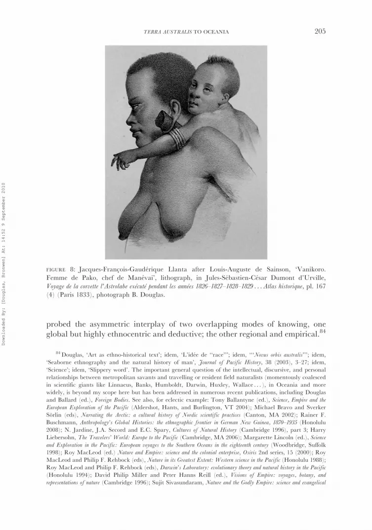
probed the asymmetric interplay of two overlapping modes of knowing, oneglobal but highly ethnocentric and deductive; the other regional and empirical.84
FIGURE 8: Jacques-Francois-Gauderique Llanta after Louis-Auguste de Sainson, ‘Vanikoro.
Femme de Pako, chef de Manevai’, lithograph, in Jules-Sebastien-Cesar Dumont d’Urville,
Voyage de la corvette l’Astrolabe execute pendant les annees 1826–1827–1828–1829 . . .Atlas historique, pl. 167(4) (Paris 1833), photograph B. Douglas.
84Douglas, ‘Art as ethno-historical text’; idem, ‘L’idee de ‘‘race’’’; idem, ‘‘‘Novus orbis australis’’’; idem,‘Seaborne ethnography and the natural history of man’, Journal of Pacific History, 38 (2003), 3–27; idem,
‘Science’; idem, ‘Slippery word’. The important general question of the intellectual, discursive, and personal
relationships between metropolitan savants and travelling or resident field naturalists (momentously coalesced
in scientific giants like Linnaeus, Banks, Humboldt, Darwin, Huxley, Wallace . . . ), in Oceania and morewidely, is beyond my scope here but has been addressed in numerous recent publications, including Douglas
and Ballard (ed.), Foreign Bodies. See also, for eclectic example: Tony Ballantyne (ed.), Science, Empire and the
European Exploration of the Pacific (Aldershot, Hants, and Burlington, VT 2004); Michael Bravo and Sverker
Sorlin (eds), Narrating the Arctic: a cultural history of Nordic scientific practices (Canton, MA 2002); Rainer F.Buschmann, Anthropology’s Global Histories: the ethnographic frontier in German New Guinea, 1870–1935 (Honolulu
2008); N. Jardine, J.A. Secord and E.C. Spary, Cultures of Natural History (Cambridge 1996), part 3; Harry
Liebersohn, The Travelers’ World: Europe to the Pacific (Cambridge, MA 2006); Margarette Lincoln (ed.), Science
and Exploration in the Pacific: European voyages to the Southern Oceans in the eighteenth century (Woodbridge, Suffolk1998); Roy MacLeod (ed.) Nature and Empire: science and the colonial enterprise, Osiris 2nd series, 15 (2000); Roy
MacLeod and Philip F. Rehbock (eds), Nature in its Greatest Extent: Western science in the Pacific (Honolulu 1988);
Roy MacLeod and Philip F. Rehbock (eds), Darwin’s Laboratory: evolutionary theory and natural history in the Pacific
(Honolulu 1994); David Philip Miller and Peter Hanns Reill (ed.), Visions of Empire: voyages, botany, and
representations of nature (Cambridge 1996); Sujit Sivasundaram, Nature and the Godly Empire: science and evangelical
TERRA AUSTRALIS TO OCEANIA 205
Downloaded By: [Douglas, Bronwen] At: 14:52 9 September 2010

FIGURE 9: Antoine Maurin after Louis-Auguste de Sainson, ‘Vanikoro. Meriko, chef a Maneve’,
lithograph, in Jules-Sebastien-Cesar Dumont d’Urville, Voyage de la corvette l’Astrolabe execute pendant
les annees 1826–1827–1828–1829 . . .Atlas historique, pl. 176 (2) (Paris 1833), photograph B. Douglas.
FIGURE 10: Laguillermie after Charles V. Monin, Oceanie: divisions de l’Oceanie, engraving (Paris1834), National Library of Australia, Canberra, MAP T 913/2. Available online at http://
www.nla.gov.au/apps/cdview?pi=nla.map-t913-2-e (accessed 27 February 2008).
206 JOURNAL OF PACIFIC HISTORY
Downloaded By: [Douglas, Bronwen] At: 14:52 9 September 2010

From different perspectives, both savants and field naturalists engaged in projectsof human taxonomy that objectified and dehumanised actual people as racialtypes. Yet, whereas the imprint of encounters was often all but effaced inuniversal racial systems, the regional classificatory efforts of travellers andresidents were always threatened by the mismatch of theory and praxis — thechallenge of trying to cram personal experience of a highly varied mix of humanphysical features, lifestyles and behaviours into neat racial slots.
A single brief example must suffice to illustrate the recurrent tension betweensystems and facts. A candid passage in Dumont d’Urville’s 1832 textsimultaneously reveals the aesthetic and discursive power of racial stereotypes,particularly the disagreeable spectre of the Negro and its Oceanic metonym, andtheir vulnerability to actual human multiplexity. In Celebes (modern Sulawesi),Dumont d’Urville saw certain individuals who were said by local interlocutors tobe inhabitants of the interior, or ‘Alfourous’. Various versions of the word Alfourou
FIGURE 10A: Laguillermie after Charles V. Monin, Oceanie: divisions de l’Oceanie, detail, engraving
(Paris 1834), National Library of Australia, Canberra, MAP T 913/2. Available online at http://
www.nla.gov.au/apps/cdview?pi=nla.map-t913-2-e (accessed 27 February 2008).
( footnote continued)
mission in the Pacific, 1795–1850 (Cambridge 2005); Martin S. Staum, Labeling People: French scholars on society, race,
and empire, 1815–1848 (Montreal & Kingston 2003).
TERRA AUSTRALIS TO OCEANIA 207
Downloaded By: [Douglas, Bronwen] At: 14:52 9 September 2010

or Alfuro recur from the 16th century onwards in rumours about the inhabitantsof inland zones in the larger islands of western Oceania, often with implications ofautochthony and primitivity.85 In this case, the term ‘instantly’ brought toDumont d’Urville’s mind the blackness, ‘frizzy hair’ and ‘flat nose’ of the ‘trueMelanesians’. Yet, to his ‘astonishment’, the people in the flesh resembled figureshe had seen in Tahiti, Tonga and New Zealand (all in Polynesia) and spoke ‘anidiom quite different from the Malays’. Should their language prove to be moreclosely related to ‘Polynesian’ than to ‘Malay’, he pronounced confidently, he‘would not hesitate’ to install Celebes as a likely ‘cradle’ of the Polynesian race or‘at least’ as a major stop in its West–East itinerary.86 But he was later forced toadmit that the alluring prospect of finding ‘a branch of the Polynesian family’ inCelebes had been dispelled by philological evidence. A word list collected on thespot convinced him that the ‘idiom’ of these alleged Alfourous belied any‘external, physical’ resemblances because it evinced ‘fewer relationships withPolynesian than with Malay’. He concluded that all three ‘tribes’ must share acommon origin, but in an ‘already very distant epoch’.87
By 1830, few Euro-Americans would have disputed Dumont d’Urville’spresumption of the material reality of discrete, physically defined, differentiallyendowed human races, though the origins, import and future implications ofracial distinctions were bitterly contested. His racial nomenclature for Oceaniawas commonly adopted in France but was viewed ambivalently by manyanglophone writers. Indeed, for much of the 19th century, English terminologiesfor Oceanian people were more varied and ambiguous than French, due in partto differing emphases in the respective fields of inquiry. In Britain before 1850,the science of man was strongly philanthropic and drew much empiricalsustenance from missionary ethnography.88 In France after 1800, the science ofrace was a highly deductive outgrowth of biology and physical anthropology, fedby the work of travelling naturalists.89 Yet, notwithstanding principledhumanitarian antipathy to the dehumanising tendencies of the science of race,English anatomists adopted racial terminology at least as early and enthusias-tically as their French counterparts.90 Moreover, English writings on man in
85 Ballard, ‘Strange alliance’; Gelpke, ‘On the Origin’, 326–30; Gene M. Moore, ‘Who are the Alfuros?’,
Conradiana, 39 (2007), 199–210.86Dumont d’Urville, ‘Sur les ıles’, 17–18; idem, Voyage, V, 435–70.87 Idem, Voyage de decouvertes de l’Astrolabe execute . . . pendant les annees 1826–1827–1828–1829 . . .Philologie, 2 vols
(Paris 1833–4), II, 193.88Helen Gardner, ‘The ‘‘faculty of faith’’: evangelical missionaries, social anthropologists, and the claim for
human unity in the 19th century’, in Douglas and Ballard (eds), Foreign Bodies, 259–82; idem, Gathering for God:George Brown in Oceania (Dunedin, NZ 2006), 105–27; Christopher Herbert, Culture and Anomie: ethnographic
imagination in the nineteenth century (Chicago 1991), 155–203; Sivasundaram, Nature and the Godly Empire; George
W. Stocking, Jr, Victorian anthropology (New York 1987), 8–109.89 Stephanie Anderson, ‘‘‘Three living Australians’’ and the Societe d’Anthropologie de Paris, 1885’, in
Douglas and Ballard (ed.), Foreign Bodies, 229–55; Douglas, ‘Climate to crania’; Moussa (ed.), L’idee de ‘race’;
Staum, Labeling People.90 E.g., Charles White, An Account of the Regular Gradation in Man, and in Different Animals and Vegetables: and
from the former to the latter (London 1799); William Lawrence, Lectures on Physiology, Zoology, and the Natural History
of Man, Delivered at the Royal College of Surgeons (London 1819).
208 JOURNAL OF PACIFIC HISTORY
Downloaded By: [Douglas, Bronwen] At: 14:52 9 September 2010

general were steadily infiltrated by racial logic, language and geography. Forexample, the authors of works on Oceania, including missionaries, routinelydifferentiated the ‘black’ ‘Polynesian negro’ from the ‘brown’ or ‘copper-coloured’ ‘proper Polynesian’, or the ‘Papuan’ race from the ‘Malayo-Polynesian’ race, before adopting varieties of Dumont d’Urville’s binarysystem early in the 20th century.91 Dumont d’Urville’s racial geography wasultimately normalised in global geopolitics and modern indigenous identities, butthe genealogies of such usages are by no means direct or unproblematic andremain to be elucidated.
THIS PAPER HAS investigated the invention of a space by Europeans, its naming,the naming of places and people within it, and — with the marriage ofgeography and raciology from the early 19th century — the unstable racialclassification of Oceanian people as Malay, Papuan, Oceanic Negro, Aborigine,Melanesian, Polynesian or Micronesian. I position these processes of knowledgeformation at the junction of shifting metropolitan discourses and ambiguousregional praxis, a strategy that leaves scope to take account of the more or lessobscure imprints of local knowledge and countersigns of indigenous agency. I canonly allude to the historical paradoxes in these processes, not least the ironicappropriations of racialist colonial terms such as Melanesian, Papuan and Kanakin the construction of anticolonial or postcolonial identities. The idea of race itselfhas a hydra-headed capacity to recur in defiance of the most determined liberalscholarly efforts to invalidate or extirpate it: as in the ongoing tendency toconflate phenotype (physical appearance) with race, whereas a race is astereotype; or in the complacent realism accorded races in popular discoursesworldwide, including indigenous usages; or in the euphemistic slippages incommon parlance from race to ethnicity or culture or religion.92 Congealed bycolonialism, racial categories and hierarchies continue to haunt the novel, oftenanomalous political borders that were negotiated by colonial states, inherited bypostcolonial ones, and are further reinscribed in the partitioning of academicresearch.
From a synchronic present political perspective, my insistence on a broadconception of Oceania may seem anomalous or quixotic since, even in French,93
Oceanie has contracted in conformity with the modern geopolitical norm that putsthe Malay Archipelago in Asia and divides Asia from Oceania along the
91 E.g., George Brown, ‘Papuans and Polynesians’, Journal of the Anthropological Institute of Great Britain and
Ireland, 16 (1887), 320; idem, Melanesians and Polynesians . . . (London 1910), 14–22; William Ellis, PolynesianResearches . . . , 4 vols (2nd edn, London 1831 [1829]), I, 78–9; John Elphinstone Erskine, Journal of a Cruise among
the Islands of the Western Pacific . . . (London 1853), 2, 4, 13, 241; John Inglis, In the New Hebrides . . . (London
1887), 5; James Cowles Prichard, Researches into the Physical History of Mankind, 5 vols (3rd edn, London 1836–47
[1813]), V, 1–285; H.A. Robertson, Erromanga the Martyr Isle, ed. John Fraser (London 1902), 1; John Williams,A Narrative of Missionary Enterprises in the South Sea Islands . . . (London 1837), 503–4, 512. See also Gardner,
Gathering for God, 114–20; Colin Kidd, The Forging of Races: race and scripture in the Protestant Atlantic world, 1600–
2000 (Cambridge 2006), 121–67.92 See, for example, Richard Jenkins, Rethinking Ethnicity: arguments and explorations (London 1997), 74–87.93Petit Larousse illustre (Paris 1977), 1569.
TERRA AUSTRALIS TO OCEANIA 209
Downloaded By: [Douglas, Bronwen] At: 14:52 9 September 2010

arbitrary colonial border which cuts the island of New Guinea in two. But as ahistorian, I prefer to invoke the long term, to disentangle the semantic history ofwords and their vernacular uses, and to expose the unthinking anachronismwhich reifies historically contingent arrangements or concepts as inevitable andeternal.
Acknowledgements
I gratefully acknowledge research support received under the Australian Research Council’s
Discovery Projects funding scheme (project number DP0665356). My thanks also to severalanonymous reviewers for insightful comments and suggestions.
ABSTRACT
This paper is a synoptic history of racial geography in the ‘fifth part of the world’ or Oceania — anextended region embracing what are now Australia, Island Southeast Asia, the Pacific Islands,
Aotearoa/New Zealand and Papua New Guinea. The period in question stretches from classical
antiquity to the Enlightenment, to focus on the consolidation of European racial thinking with themarriage of geography and raciology in the early 19th century. The paper investigates the naming
of places by Europeans and its ultimate entanglement with their racial classifications of people. The
formulation of geographical and anthropological knowledge is located at the interface ofmetropolitan discourses and local experience. This necessitates unpacking the relationships
between, on the one hand, the deductive reasoning of metropolitan savants, and, on the other
hand, the empirical logic of voyagers and settlers who had visited or lived in particular places,
encountered their inhabitants, and been exposed, often unwittingly, to indigenous agency andknowledge.
210 JOURNAL OF PACIFIC HISTORY
Downloaded By: [Douglas, Bronwen] At: 14:52 9 September 2010


