Embed Size (px)
Citation preview
at SciVerse ScienceDirect
Journal of South American Earth Sciences 42 (2013) 186e193
Contents lists available
Journal of South American Earth Sciences
journal homepage: www.elsevier .com/locate/ jsames
Sulphate efflorescences at the geyser near Pinchollo, southern Peru
Justyna Ciesielczuk a,*, Jerzy _Zaba a, Gra _zyna Bzowska a, Krzysztof Gaidzik a, Magdalena G1ogowska b
aUniversity of Silesia, Faculty of Earth Sciences, Bedzinska 60, 41-200 Sosnowiec, PolandbCentral Mining Institute, Plac Gwarków 1, 40-166 Katowice, Poland
a r t i c l e i n f o
Article history:Received 22 December 2011Accepted 23 June 2012
Keywords:GeyserMineral precipitatesSulphatesHot springsPeru
* Corresponding author. Tel.: þ48 32 3689336.E-mail address: [email protected] (J. C
0895-9811/$ e see front matter � 2012 Elsevier Ltd.http://dx.doi.org/10.1016/j.jsames.2012.06.016
a b s t r a c t
Sulphate mineralization precipitated around a geyser located above the village of Pinchollo, Chivaydistrict and below Hualca Hualca volcano (6025 m a.s.l.) in the Western Cordillera of southern Peru isdescribed. The geyser is one of many manifestations of thermal activity in the Arequipa department. Itsage is estimated to be Upper PleistoceneeHolocene, as the discharge point lies at the intersection ofa fault system with latitudinal dip-slip fault cutting a volcanic-debris avalanche of probably Pleistoceneage. Thermal waters present in the Chivay district are mainly chloride-rich with a neutral pH. They arerich in Li, Sr, and B. The water erupting in the geyser boils at about 85 �C, as it lies at some 4353 m a.s.l.
The minerals examined, of various habits and various yellow, orange and white colours wereprecipitated on the soil and on plants close to the geyser (location 1), on the walls of a 1 m diameterpothole filled with boiling water (location 1a) and at a distance of some 100 m to the west of the geyser(location 2). All are sulphates. Their chemical composition is fairly simple, consisting of Al, Fe, K, Mg, Ca,S, NH4 and O, and all display chemical zoning. But the phase composition is more complex. In all loca-tions, alunogene, copiapite, coquimbite, tschermigite and gypsum are present. Close to the geyser(location 1) magnesium-containing sulphates, namely, boussingaultite and pickeringite also occur. Ironsulphates such as mohrite and rozenite precipitate on the walls of the pothole (location 1a). Sulphatescontaining potassium such as jarosite, alunite and voltaiteevoltaite (Mg) dominate among the efflo-rescences in location 2, where hematite was also noted. Any quartz and kaolinite or illite/mica admixtureidentified in some samples derives from adjacent soil.
The present geothermal system does not involve the deposition of precious-metal deposits such asthose associated with an earlier deep-going epithermal system that scavenged a large volume of rock.Most likely, as the present-day thermal waters do not involve a juvenile-water component, the geyserwaters derive from a shallower source.
� 2012 Elsevier Ltd. All rights reserved.
1. Introduction
Hot springs in the Southern Andes of Peru were investigated in1996 and 1997 by the Instituto Geológico Minero y Metalúrgico(INGEMMET) to evaluate the possibility of generating electricityand of using hot water for heating and bathing purposes. Present-day geothermal activity there is represented by hot springs,fumaroles and surface precipitates related to active- or dormant-stratovolcanoes. Twelve areas with the highest geothermal poten-tials in Peru were identified: Puquio, Parinacochas, Cotahuasi,Coropuna, Orcopampa, Cailloma, Chivay, Chachani, Ubinas, Calacoa,Tutupaca and Rio Maure (Steinmüller, 2001). The Chivaygeothermal area extends along Rio Colca from Callali to the mouthof Rio Ayo (Fig. 1). Volcanism and thermal activity in Southern Peru
iesielczuk).
All rights reserved.
is connected with an active subduction zone e the underthrustingof the Nazca Plate under the South American Plate. The process hasgenerated high heat flows since Jurassic times, plutonism andsubmarine volcanism during theMesozoic (Aguirre and Offer,1985)and subaerial volcanic activity in the Cenozoic. Steinmüller (2001)distinguishes two geothermal systems in South Peru. One, deep andlong-term, resulted in the leaching of large rock volumes, highprecious-metal concentrations in the fluids and the deposition ofeconomic epithermal precious-metal deposits during the Neogene.The second, shallow and short-term, has a lower capacity tomobilize and transport host-rock metals. Fluids generated by thissecond geothermal system were incapable of forming economicmineralization. Nevertheless, they precipitated a set of mineralswhich may reflect the chemical composition of the thermal waterand indicate its source.
The aim of this study is to describe the surface sulphate efflo-rescences which precipitated from thermal water in the vicinity ofthe geyser presently active to the south of Pinchollo village, Chivay
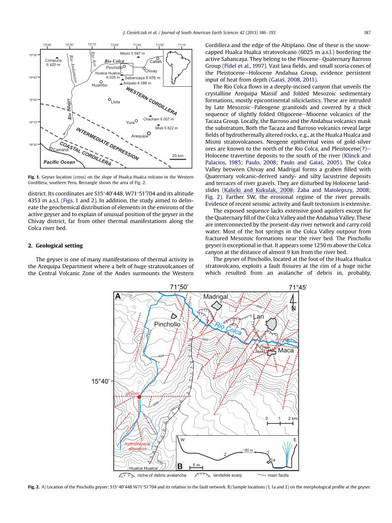
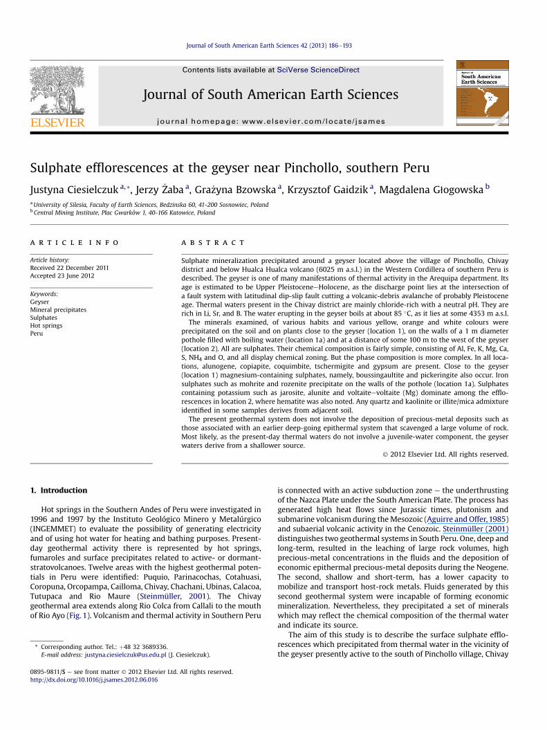
Fig. 1. Geyser location (cross) on the slope of Hualca Hualca volcano in the WesternCordillera, southern Peru. Rectangle shows the area of Fig. 2.
J. Ciesielczuk et al. / Journal of South American Earth Sciences 42 (2013) 186e193 187
district. Its coordinates are S15�400448, W71�510704 and its altitude4353 m a.s.l. (Figs. 1 and 2). In addition, the study aimed to delin-eate the geochemical distribution of elements in the environs of theactive geyser and to explain of unusual position of the geyser in theChivay district, far from other thermal manifestations along theColca river bed.
2. Geological setting
The geyser is one of many manifestations of thermal activity inthe Arequipa Department where a belt of huge stratovolcanoes ofthe Central Volcanic Zone of the Andes surmounts the Western
A
B
Fig. 2. A) Location of the Pinchollo geyser: S15�400448 W71�510704 and its relation to the fau
Cordillera and the edge of the Altiplano. One of these is the snow-capped Hualca Hualca stratovolcano (6025 m a.s.l.) bordering theactive Sabancaya. They belong to the PlioceneeQuaternary BarrosoGroup (Fídel et al., 1997). Vast lava fields, and small scoria cones ofthe PleistoceneeHolocene Andahua Group, evidence persistentinput of heat from depth (Ga1a�s, 2008, 2011).
The Rio Colca flows in a deeply-incised canyon that unveils thecrystalline Arequipa Massif and folded Mesozoic sedimentaryformations, mostly epicontinental siliciclastics. These are intrudedby Late MesozoicePaleogene granitoids and covered by a thicksequence of slightly folded OligoceneeMiocene volcanics of theTacaza Group. Locally, the Barroso and the Andahua volcanics maskthe substratum. Both the Tacaza and Barroso volcanics reveal largefields of hydrothermally altered rocks, e.g., at the Hualca Hualca andMismi stratovolcanoes. Neogene epithermal veins of gold-silverores are known to the north of the Rio Colca, and Pleistocene(?)eHolocene travertine deposits to the south of the river (Klinck andPalacios, 1985; Paulo, 2008; Paulo and Ga1a�s, 2005). The ColcaValley between Chivay and Madrigal forms a graben filled withQuaternary volcanic-derived sandy- and silty lacustrine depositsand terraces of river gravels. They are disturbed by Holocene land-slides (Kalicki and Kukulak, 2008; _Zaba and Ma1olepszy, 2008;Fig. 2). Farther SW, the erosional regime of the river prevails.Evidence of recent seismic activity and fault tectonism is extensive.
The exposed sequence lacks extensive good aquifers except fortheQuaternaryfill of the Colca Valley and the AndahuaValley. Theseare interconnected by the present-day river network and carry coldwater. Most of the hot springs in the Colca Valley outpour fromfractured Mesozoic formations near the river bed. The Pinchollogeyser is exceptional in that. It appears some1250mabove theColcacanyon at the distance of almost 9 km from the river bed.
The geyser of Pinchollo, located at the foot of the Hualca Hualcastratovolcano, exploits a fault fissures at the rim of a huge nichewhich resulted from an avalanche of debris in, probably,
lt network. B) Sample locations (1, 1a and 2) on the morphological profile at the geyser.
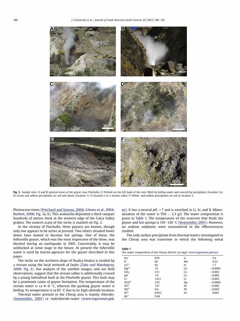
Fig. 3. Sample sites: A and B) general views of the geyser near Pinchollo. C) Pothole on the left bank of the river filled by boiling water and covered by precipitates (location 1a).D) Green and yellow precipitates on soil and plants (location 1). E) location 2 in a stream valley. F) White- and yellow precipitates on soil at location 2.
Table 1The water composition of the Chivay district (in mg/l; www.ingemmet.gob.pe).
Naþ 876 Li 5.6Kþ 66 Mn 0.22Ca2þ 62 Sr 1.7Mg2þ 14 Cd <0.0002SiO2 212 Cu <0.002pH 7.6 Co <0.005Cl� 1412 Cr <0.005HCO3� 210 Hg <0.0002SO4� 147 Ni <0.005NO3� 0.6 Pb <0.002Al3þ 0.022 Zn 0.061Ba2þ 0.46
J. Ciesielczuk et al. / Journal of South American Earth Sciences 42 (2013) 186e193188
Pleistocene times (Pritchard and Simons, 2004; Gómez et al., 2004;Burkett, 2008; Fig. 3a, b). This avalanche deposited a thick ramparthundreds of metres thick at the western edge of the Colca Valleygraben. The eastern scarp of the niche is marked on Fig. 2.
In the vicinity of Pinchollo, three geysers are known, thoughonly one appears to be active at present. Two others situated lowerdown have waned to become hot springs. One of these, theInfiernillo geyser, which was the most impressive of the three, wasblocked during an earthquake in 2001. Conceivably, it may beunblocked at some stage in the future. At present the Infiernilloname is used by tourist-agencies for the geyser described in thispaper.
The niche on the northern slope of Hualca Hualca is eroded bya stream using the local network of faults ( _Zaba and Ma1olepszy,2009; Fig. 2). Our analysis of the satellite images, and our fieldobservations, suggest that the stream valley is additionally crossedby a young latitudinal fault at the Pinchollo geyser. This fault maybe a proximate cause of geyser formation. The temperature of thestream water is ca 4e6 �C, whereas the gushing geyser water isboiling. Its temperature is ca 85 �C due to its high-altitude location.
Thermal water present in the Chivay area is mainly chloride-(Steinmüller, 2001) or sodichloride-water (www.ingemmet.gob.
pe). It has a neutral pH w7 and is enriched in Li, Sr, and B. Miner-alization of the water is TDS ¼ 2.3 g/l. The water composition isgiven in Table 1. The temperature of the reservoir that feeds thegeyser and hot springs is 110e120 �C (Steinmüller, 2001). However,no sodium sulphates were encountered in the efflorescencesstudied.
The only surface precipitate from thermal waters investigated inthe Chivay area was travertine in which the following metal
J. Ciesielczuk et al. / Journal of South American Earth Sciences 42 (2013) 186e193 189
contents were measured: Pb (15 ppm), Zn (45 ppm), Cu(<12.5 ppm), Au (<0.01 ppm), Ag (<0.2 ppm), As (<48 ppm) andHg (0.3 ppm).
3. Sampling and methodology
In the vicinity of the geyser, samples of mineral precipitateswere collected at two localities (Figs. 2 and 3). The first (location 1)is close to the geyser and lies mainly on the left bank of the river.Within it, there is a pothole of 1 m diameter filled with boilingwater (location 1a). The second (location 2) is ca 100 mwest of thegeyser where a small stream valley reveals the presence ofprecipitates around cracks and fissures in soil.
Minerals of various habits and colours were collected as sepa-rately as possible and placed into bags. The collected samples weredried for one week in the open air and then sealed hermetically.
All samples were examined by binocular microscope. Selectedfragments were stuck onto carbon tape or encased in epoxy resin,then cut and polished. Chemical compositions and mineral habitswere investigated using a Philips XL 30 ESEM/TMP scanning elec-tron microscope (SEM) coupled to an energy-dispersive spec-trometer (EDS; EDAX type Sapphire). Analytical conditions were as
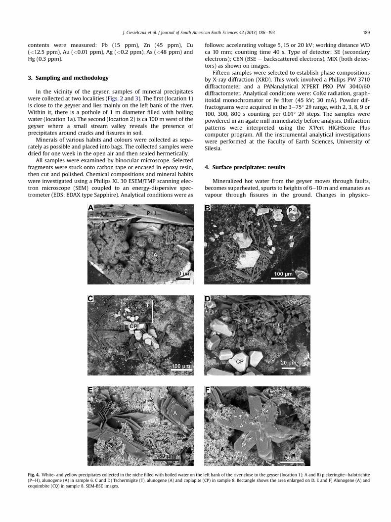
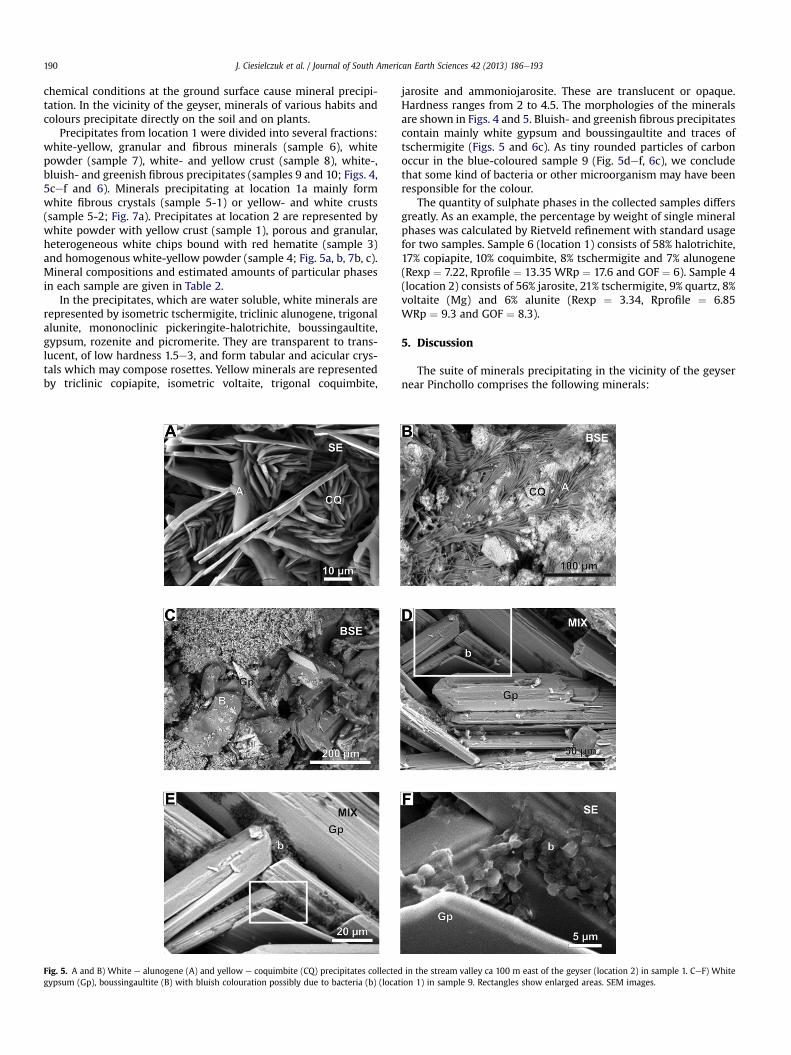
Fig. 4. White- and yellow precipitates collected in the niche filled with boiled water on the(PeH), alunogene (A) in sample 6. C and D) Tschermigite (T), alunogene (A) and copiapite (coquimbite (CQ) in sample 8. SEM-BSE images.
follows: accelerating voltage 5, 15 or 20 kV; working distance WDca 10 mm; counting time 40 s. Type of detector: SE (secondaryelectrons); CEN (BSE e backscattered electrons), MIX (both detec-tors) as shown on images.
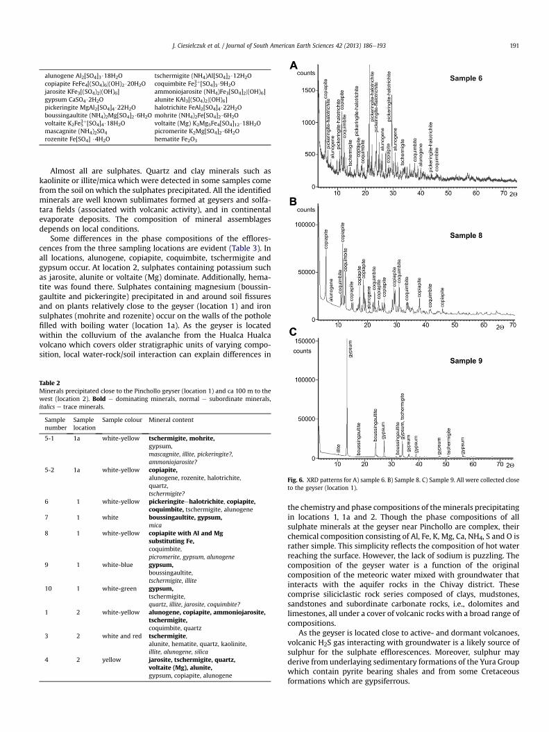
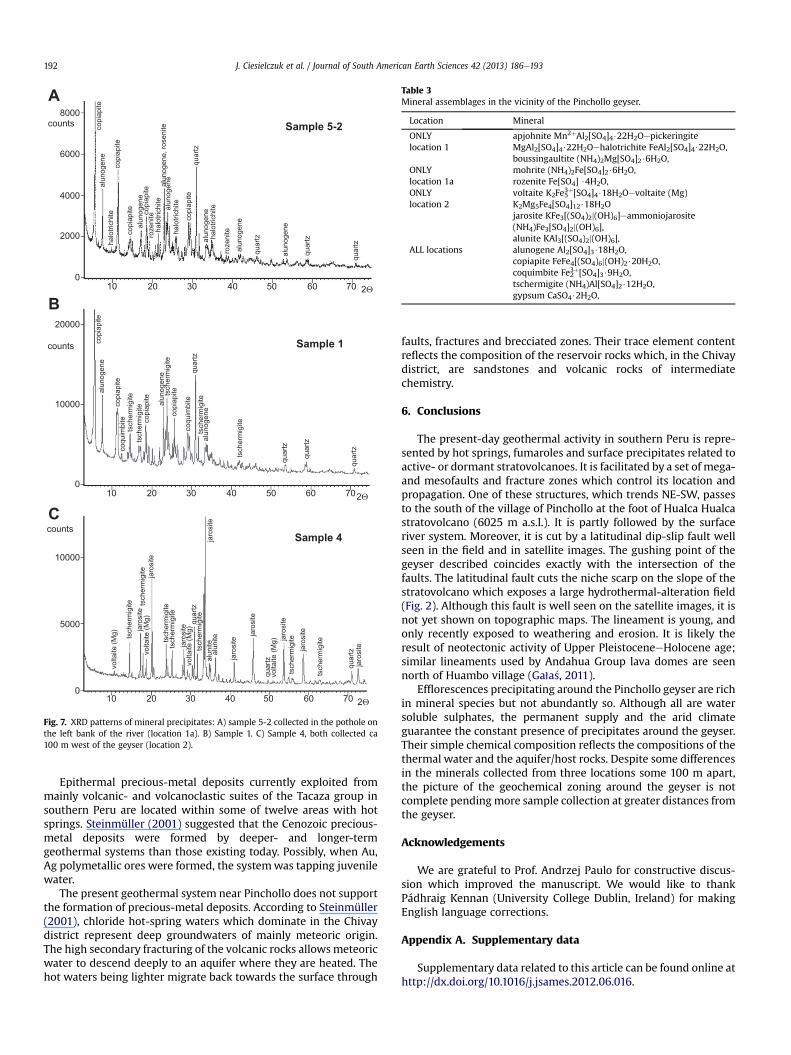
Fifteen samples were selected to establish phase compositionsby X-ray diffraction (XRD). This work involved a Philips PW 3710diffractometer and a PANanalytical X’PERT PRO PW 3040/60diffractometer. Analytical conditions were: CoKa radiation, graph-itoidal monochromator or Fe filter (45 kV; 30 mA). Powder dif-fractograms were acquired in the 3e75� 2q range, with 2, 3, 8, 9 or100, 300, 800 s counting per 0.01� 2q steps. The samples werepowdered in an agate mill immediately before analysis. Diffractionpatterns were interpreted using the X’Pert HIGHScore Pluscomputer program. All the instrumental analytical investigationswere performed at the Faculty of Earth Sciences, University ofSilesia.
4. Surface precipitates: results
Mineralized hot water from the geyser moves through faults,becomes superheated, spurts to heights of 6e10m and emanates asvapour through fissures in the ground. Changes in physico-
left bank of the river close to the geyser (location 1): A and B) pickeringiteehalotrichiteCP) in sample 8. Rectangle shows the area enlarged on D. E and F) Alunogene (A) and
J. Ciesielczuk et al. / Journal of South American Earth Sciences 42 (2013) 186e193190
chemical conditions at the ground surface cause mineral precipi-tation. In the vicinity of the geyser, minerals of various habits andcolours precipitate directly on the soil and on plants.
Precipitates from location 1 were divided into several fractions:white-yellow, granular and fibrous minerals (sample 6), whitepowder (sample 7), white- and yellow crust (sample 8), white-,bluish- and greenish fibrous precipitates (samples 9 and 10; Figs. 4,5cef and 6). Minerals precipitating at location 1a mainly formwhite fibrous crystals (sample 5-1) or yellow- and white crusts(sample 5-2; Fig. 7a). Precipitates at location 2 are represented bywhite powder with yellow crust (sample 1), porous and granular,heterogeneous white chips bound with red hematite (sample 3)and homogenous white-yellow powder (sample 4; Fig. 5a, b, 7b, c).Mineral compositions and estimated amounts of particular phasesin each sample are given in Table 2.
In the precipitates, which are water soluble, white minerals arerepresented by isometric tschermigite, triclinic alunogene, trigonalalunite, mononoclinic pickeringite-halotrichite, boussingaultite,gypsum, rozenite and picromerite. They are transparent to trans-lucent, of low hardness 1.5e3, and form tabular and acicular crys-tals which may compose rosettes. Yellow minerals are representedby triclinic copiapite, isometric voltaite, trigonal coquimbite,
Fig. 5. A and B) White e alunogene (A) and yellow e coquimbite (CQ) precipitates collectedgypsum (Gp), boussingaultite (B) with bluish colouration possibly due to bacteria (b) (loca
jarosite and ammoniojarosite. These are translucent or opaque.Hardness ranges from 2 to 4.5. The morphologies of the mineralsare shown in Figs. 4 and 5. Bluish- and greenish fibrous precipitatescontain mainly white gypsum and boussingaultite and traces oftschermigite (Figs. 5 and 6c). As tiny rounded particles of carbonoccur in the blue-coloured sample 9 (Fig. 5def, 6c), we concludethat some kind of bacteria or other microorganism may have beenresponsible for the colour.
The quantity of sulphate phases in the collected samples differsgreatly. As an example, the percentage by weight of single mineralphases was calculated by Rietveld refinement with standard usagefor two samples. Sample 6 (location 1) consists of 58% halotrichite,17% copiapite, 10% coquimbite, 8% tschermigite and 7% alunogene(Rexp ¼ 7.22, Rprofile ¼ 13.35 WRp ¼ 17.6 and GOF ¼ 6). Sample 4(location 2) consists of 56% jarosite, 21% tschermigite, 9% quartz, 8%voltaite (Mg) and 6% alunite (Rexp ¼ 3.34, Rprofile ¼ 6.85WRp ¼ 9.3 and GOF ¼ 8.3).
5. Discussion
The suite of minerals precipitating in the vicinity of the geysernear Pinchollo comprises the following minerals:
in the stream valley ca 100 m east of the geyser (location 2) in sample 1. CeF) Whitetion 1) in sample 9. Rectangles show enlarged areas. SEM images.
alunogene Al2[SO4]3$18H2O tschermigite (NH4)Al[SO4]2$12H2Ocopiapite FeFe4[(SO4)6j(OH)2$20H2O coquimbite Fe23þ[SO4]3$9H2Ojarosite KFe3[(SO4)2j(OH)6] ammoniojarosite (NH4)Fe3[SO4]2j(OH)6]gypsum CaSO4$2H2O alunite KAl3[(SO4)2j(OH)6]pickeringite MgAl2[SO4]4$22H2O halotrichite FeAl2[SO4]4$22H2Oboussingaultite (NH4)2Mg[SO4]2$6H2O mohrite (NH4)2Fe[SO4]2$6H2Ovoltaite K2Fe53þ[SO4]4$18H2O voltaite (Mg) K2Mg5Fe4[SO4]12$18H2Omascagnite (NH4)2SO4 picromerite K2Mg[SO4]2$6H2Orozenite Fe[SO4] $4H2O hematite Fe2O3
J. Ciesielczuk et al. / Journal of South American Earth Sciences 42 (2013) 186e193 191
Almost all are sulphates. Quartz and clay minerals such askaolinite or illite/mica which were detected in some samples comefrom the soil on which the sulphates precipitated. All the identifiedminerals are well known sublimates formed at geysers and solfa-tara fields (associated with volcanic activity), and in continentalevaporate deposits. The composition of mineral assemblagesdepends on local conditions.
Some differences in the phase compositions of the efflores-cences from the three sampling locations are evident (Table 3). Inall locations, alunogene, copiapite, coquimbite, tschermigite andgypsum occur. At location 2, sulphates containing potassium suchas jarosite, alunite or voltaite (Mg) dominate. Additionally, hema-tite was found there. Sulphates containing magnesium (boussin-gaultite and pickeringite) precipitated in and around soil fissuresand on plants relatively close to the geyser (location 1) and ironsulphates (mohrite and rozenite) occur on the walls of the potholefilled with boiling water (location 1a). As the geyser is locatedwithin the colluvium of the avalanche from the Hualca Hualcavolcano which covers older stratigraphic units of varying compo-sition, local water-rock/soil interaction can explain differences in
Table 2Minerals precipitated close to the Pinchollo geyser (location 1) and ca 100 m to thewest (location 2). Bold e dominating minerals, normal e subordinate minerals,italics e trace minerals.
Samplenumber
Samplelocation
Sample colour Mineral content
5-1 1a white-yellow tschermigite, mohrite,gypsum,mascagnite, illite, pickeringite?,ammoniojarosite?
5-2 1a white-yellow copiapite,alunogene, rozenite, halotrichite,quartz,tschermigite?
6 1 white-yellow pickeringiteehalotrichite, copiapite,coquimbite, tschermigite, alunogene
7 1 white boussingaultite, gypsum,mica
8 1 white-yellow copiapite with Al and Mgsubstituting Fe,coquimbite,picromerite, gypsum, alunogene
9 1 white-blue gypsum,boussingaultite,tschermigite, illite
10 1 white-green gypsum,tschermigite,quartz, illite, jarosite, coquimbite?
1 2 white-yellow alunogene, copiapite, ammoniojarosite,tschermigite,coquimbite, quartz
3 2 white and red tschermigite,alunite, hematite, quartz, kaolinite,illite, alunogene, silica
4 2 yellow jarosite, tschermigite, quartz,voltaite (Mg), alunite,gypsum, copiapite, alunogene
Fig. 6. XRD patterns for A) sample 6. B) Sample 8. C) Sample 9. All were collected closeto the geyser (location 1).
the chemistry and phase compositions of theminerals precipitatingin locations 1, 1a and 2. Though the phase compositions of allsulphate minerals at the geyser near Pinchollo are complex, theirchemical composition consisting of Al, Fe, K, Mg, Ca, NH4, S and O israther simple. This simplicity reflects the composition of hot waterreaching the surface. However, the lack of sodium is puzzling. Thecomposition of the geyser water is a function of the originalcomposition of the meteoric water mixed with groundwater thatinteracts with the aquifer rocks in the Chivay district. Thesecomprise siliciclastic rock series composed of clays, mudstones,sandstones and subordinate carbonate rocks, i.e., dolomites andlimestones, all under a cover of volcanic rocks with a broad range ofcompositions.
As the geyser is located close to active- and dormant volcanoes,volcanic H2S gas interacting with groundwater is a likely source ofsulphur for the sulphate efflorescences. Moreover, sulphur mayderive from underlaying sedimentary formations of the Yura Groupwhich contain pyrite bearing shales and from some Cretaceousformations which are gypsiferrous.
A
B
C
Fig. 7. XRD patterns of mineral precipitates: A) sample 5-2 collected in the pothole onthe left bank of the river (location 1a). B) Sample 1. C) Sample 4, both collected ca100 m west of the geyser (location 2).
Table 3Mineral assemblages in the vicinity of the Pinchollo geyser.
Location Mineral
ONLYlocation 1
apjohnite Mn2þAl2[SO4]4$22H2OepickeringiteMgAl2[SO4]4$22H2Oehalotrichite FeAl2[SO4]4$22H2O,boussingaultite (NH4)2Mg[SO4]2$6H2O,
ONLYlocation 1a
mohrite (NH4)2Fe[SO4]2$6H2O,rozenite Fe[SO4] $4H2O,
ONLYlocation 2
voltaite K2Fe53þ[SO4]4$18H2Oevoltaite (Mg)K2Mg5Fe4[SO4]12$18H2Ojarosite KFe3[(SO4)2j(OH)6]eammoniojarosite(NH4)Fe3[SO4]2j(OH)6],alunite KAl3[(SO4)2j(OH)6],
ALL locations alunogene Al2[SO4]3$18H2O,copiapite FeFe4[(SO4)6j(OH)2$20H2O,coquimbite Fe23þ[SO4]3$9H2O,tschermigite (NH4)Al[SO4]2$12H2O,gypsum CaSO4$2H2O,
J. Ciesielczuk et al. / Journal of South American Earth Sciences 42 (2013) 186e193192
Epithermal precious-metal deposits currently exploited frommainly volcanic- and volcanoclastic suites of the Tacaza group insouthern Peru are located within some of twelve areas with hotsprings. Steinmüller (2001) suggested that the Cenozoic precious-metal deposits were formed by deeper- and longer-termgeothermal systems than those existing today. Possibly, when Au,Ag polymetallic ores were formed, the systemwas tapping juvenilewater.
The present geothermal system near Pinchollo does not supportthe formation of precious-metal deposits. According to Steinmüller(2001), chloride hot-spring waters which dominate in the Chivaydistrict represent deep groundwaters of mainly meteoric origin.The high secondary fracturing of the volcanic rocks allowsmeteoricwater to descend deeply to an aquifer where they are heated. Thehot waters being lighter migrate back towards the surface through
faults, fractures and brecciated zones. Their trace element contentreflects the composition of the reservoir rocks which, in the Chivaydistrict, are sandstones and volcanic rocks of intermediatechemistry.
6. Conclusions
The present-day geothermal activity in southern Peru is repre-sented by hot springs, fumaroles and surface precipitates related toactive- or dormant stratovolcanoes. It is facilitated by a set of mega-and mesofaults and fracture zones which control its location andpropagation. One of these structures, which trends NE-SW, passesto the south of the village of Pinchollo at the foot of Hualca Hualcastratovolcano (6025 m a.s.l.). It is partly followed by the surfaceriver system. Moreover, it is cut by a latitudinal dip-slip fault wellseen in the field and in satellite images. The gushing point of thegeyser described coincides exactly with the intersection of thefaults. The latitudinal fault cuts the niche scarp on the slope of thestratovolcano which exposes a large hydrothermal-alteration field(Fig. 2). Although this fault is well seen on the satellite images, it isnot yet shown on topographic maps. The lineament is young, andonly recently exposed to weathering and erosion. It is likely theresult of neotectonic activity of Upper PleistoceneeHolocene age;similar lineaments used by Andahua Group lava domes are seennorth of Huambo village (Ga1a�s, 2011).
Efflorescences precipitating around the Pinchollo geyser are richin mineral species but not abundantly so. Although all are watersoluble sulphates, the permanent supply and the arid climateguarantee the constant presence of precipitates around the geyser.Their simple chemical composition reflects the compositions of thethermal water and the aquifer/host rocks. Despite some differencesin the minerals collected from three locations some 100 m apart,the picture of the geochemical zoning around the geyser is notcomplete pendingmore sample collection at greater distances fromthe geyser.
Acknowledgements
We are grateful to Prof. Andrzej Paulo for constructive discus-sion which improved the manuscript. We would like to thankPádhraig Kennan (University College Dublin, Ireland) for makingEnglish language corrections.
Appendix A. Supplementary data
Supplementary data related to this article can be found online athttp://dx.doi.org/10.1016/j.jsames.2012.06.016.
J. Ciesielczuk et al. / Journal of South American Earth Sciences 42 (2013) 186e193 193
References
Aguirre, L., Offer, R., 1985. Burial metamorphism in the Western Peruvian Trough:its relationship to Andean magmatism and tectonics. In: Pitcher, W.W.,Atherton, M.P., Cobbing, E.J., Beckinsale, R.L. (Eds.), Magmatism at a Plate Edge:The Peruvian Andes. Blackie, Glasgow UK, pp. 59e71.
Burkett, B., 2008. Andean Volcanism: Nevado Hualca Hualca volcano, SouthernPeru, and El Reventador Volcano, Ecuador. M.S. Geology thesis at the Universityat Buffalo, State University of New York.
Fídel, S.L., Morche, W., Nuñez, J.S., 1997. Inventario de volcanoes del Peru. INGEM-MET, 15, Lima.
Ga1a�s, A., 2008. Extent and volcanic’s constructions of the Andahua group. Geologia34 (2/1). pp. 107e136.
Ga1a�s, A., 2011. The extent and volcanic structures of the Quaternary AndahuaGroup, Andes, southern Peru. Annales Societatis Geologorum Poloniae 81 (1).pp. 1e19.
Gómez, A.J.C., Macias, J.L., Siebe, C., Ocola, A.L., 2004. Debris avalanche deposit ofHualca Hualca volcano and the formation of a volcanic dam in the Colca Valley,Arequipa e Peru. In: International Association of Volcanology and Chemistry ofthe Earth Interior General Assembly, Chile.
http://www.ingemmet.gob.pe/novedades/workshop/A3CHEM.pdf.Kalicki, T., Kukulak, J., 2008. Evolución Cuaternaria del Valle y del Cañón del Colca:
informe de los Examenes Geomorfológicos llevados a cabo en el Año 2006. In:
Novoa Goicochea, Z.I. (Ed.), Expedición Científica Polaca, Cañon del Colca.Sociedad Geográfica de Lima, Geología, pp. 55e80.
Klinck, B.A., Palacios, M., 1985. Mapa Geologico del Cuadrangulo de Chivay. Escala1:100000. Instituto Geologico Minero y Metalurgico, Peru.
Paulo, A., 2008. Geology of the Western Cordillera in Southern Peru. Geologia 34 (2/1). pp. 35e54.
Paulo, A., Ga1a�s, A., 2005. Epithermal gold and silver deposits in the Orcopampa andCaylloma regions, south Peru. Przeglad Geologiczny 53 (8). pp. 639e648(in Polish with English summary).
Pritchard, M.E., Simons, M., 2004. An InSAR-based survey of volcanic deformation inthe central Andes. Geochemistry Geophysics Geosystems 5 (Q02002). pp. 1e41.http://dx.doi.org/10.1029/2003GC000610.
Steinmüller, K., 2001. Modern hot springs in the southern volcanic Cordillera ofPeru and their relationship to Neogene epithermal precious-metal deposits.Journal of South American Earth Sciences 14. pp. 377e385.
_Zaba, J., Ma1olepszy, Z., 2008. Landslide hazard related to tectonic activity in the RioColca Valley, Peru. In: Paulo, A. (Ed.), 2008. Problems of the EnvironmentalResources Management, vol. 24(2/2). Mineral Resources Management,pp. 117e134 (in Polish with English summary).
_Zaba, J., Ma1olepszy, Z., 2009. La Actividad de las fallas en el Valle del Río Colca en elsector Pinchollo-Maca, los Andes Centrales. In: Novoa Goicochea, Z.I. (Ed.),Expedición Científica Polaca, Cañon del Colca. Sociedad Geográfica de Lima,Geología, pp. 81e106.


